24 C14-2023-0110 - 1230 E. 38th 12 Street; District 9 — original pdf
Backup
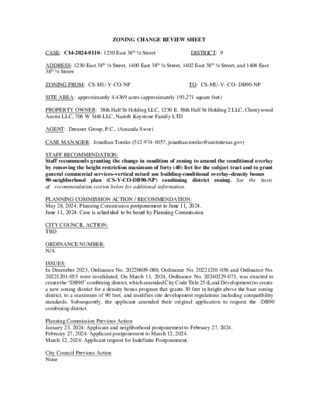
ZONING CHANGE REVIEW SHEET CASE: C14-2024-0110– 1230 East 38th ½ Street DISTRICT: 9 ADDRESS: 1230 East 38th ½ Street, 1400 East 38th ½ Street, 1402 East 38th ½ Street, and 1406 East 38th ½ Street ZONING FROM: CS-MU-V-CO-NP TO: CS-MU-V- CO- DB90-NP SITE AREA: approximately 4.4369 acres (approximately 193,271 square feet) PROPERTY OWNER: 38th Half St Holding LLC, 1230 E. 38th Half St Holding 2 LLC, Cherrywood Austin LLC, 706 W 34th LLC, Nasteb Keystone Family LTD AGENT: Drenner Group, P.C., (Amanda Swor) CASE MANAGER: Jonathan Tomko (512-974-1057, jonathan.tomko@austintexas.gov) STAFF RECOMMENDATION: Staff recommends granting the change in condition of zoning to amend the conditional overlay by removing the height restriction maximum of forty (40) feet for the subject tract and to grant general commercial services–vertical mixed use building-conditional overlay–density bonus 90-neighborhood plan (CS-V-CO-DB90-NP) combining district zoning. See of recommendation section below for additional information. the basis PLANNING COMMISSION ACTION / RECOMMENDATION: May 28, 2024: Planning Commission postponement to June 11, 2024. June 11, 2024: Case is scheduled to be heard by Planning Commission CITY COUNCIL ACTION: TBD ORDINANCE NUMBER: N/A ISSUES: In December 2023, Ordinance No. 20220609-080, Ordinance No. 20221201-056 and Ordinance No. 20221201-055 were invalidated. On March 11, 2024, Ordinance No. 20240229-073, was enacted to create the “DB90” combining district, which amended City Code Title 25 (Land Development) to create a new zoning district for a density bonus program that grants 30 feet in height above the base zoning district, to a maximum of 90 feet, and modifies site development regulations including compatibility standards. Subsequently, the applicant amended their original application to request the -DB90 combining district. Planning Commission Previous Action January 23, 2024: Applicant and neighborhood postponement to February 27, 2024. February 27, 2024: Applicant postponement to March 12, 2024. March 12, 2024: Applicant request for Indefinite Postponement. City Council Previous Action None C14-2023-0110 Page 2 CASE MANAGER COMMENTS: The subject tract includes a number of uses, Alma Cherrywood Apartment Complex (formerly known as Delwood Station Apartments); Westbank Dry Cleaning Warehouse; Cherrywood Coffeehouse; Monarch Food Mart, and GC Cleaners and Laundry. To the north (across the railroad tracks) are several duplexes that are part of what is known as “Duplex Nation,” a large collection of duplexes built in the late 1940s. To the east (across the railroad tracks) is Maplewood Elementary and several duplexes built in the late 1940s. To the west is Delwood Marketplace, a large shopping center of over 100,000 square feet built in approximately 1992. The shopping center includes a Fiesta Grocery Store and over 50,000 square feet of paved parking lot. To the south are several single-family homes built in the 1940s and 1950s. There are at least three single family homes that operate small office uses, such as an acupuncture office, and some other home offices along the south side of East 38th 1/2 Street. The applicant is requesting general commercial services–vertical mixed use building-conditional overlay–density bonus 90-neighborhood plan (CS-V -CO-DB90-NP) combining district zoning for a proposed development that would include multi-family units requiring an affordable component. A building constructed under density bonus 90 (–DB90) standards allows for a mix of residential uses and commercial uses, and the result is typically retail, restaurants and offices on the ground floor, and residential units on upper levels. The property is located within the Upper Boggy Creek Neighborhood Plan Area, and is located within an area that was initiated by the City to zone certain tracts within the Neighborhood Plan area to accommodate the -V zoning district in 2008 (Ordinance No. 20071213-089). A development utilizing the “density bonus 90” incentives is permitted with a base CS district, and must include an affordability component for residential use in order to obtain incentives, including height maximum of 90 feet in the CS district (60 feet base plus 30 feet incentive) and relaxation of development and compatibility standards, such as FAR, setbacks and building coverage. There are several methods of satisfying DB90 development affordability requirements. There are two options for projects including rental units: 1) a minimum of 12% of the rental units in a building are affordable for a 40-year period for households earning 60% or less than the Austin-Round Rock Metropolitan Statistical Area MFI; or 2) a minimum of 10% of the rental units are affordable for a 40-year period as described above for households earning 50% or less MFI. There are two options of satisfying DB90 development affordability requirements which include ownership units: 1) a minimum of 12% of the rental units in a building are affordable for a 40-year period for households earning 80% or less than the Austin-Round Rock Metropolitan Statistical Area MFI; or 2) an in-lieu-fee payment to the Housing Trust Fund, equivalent to the required percentage of the total residential units, including the mix of bedrooms required, at the rate set in the fee schedule at the time of final site plan submission. BASIS OF RECOMMENDATION: 1. The rezoning should be consistent with the policies and principles adopted by the City Council. The City Council and Planning Commission have made clear the need to promote housing density around transportation assets. This site is proximate to Manor Road, the Red Line Trail, and MLK Red Line Stop. Imposing height restrictions reduces the number of households that could benefit from being able to live near these transportation assets. The height restriction is inconsistent with policies and principles adopted by City Council and Planning Commission. C14-2023-0110 Page 3 City Council has provided policy and direction for having more residential density and increased affordability, as well as incentivizing vertical mixed use buildings throughout the City. This request is consistent with the “VMU2” option and Ordinance No. 20240229-073, which replaced the invalidated “VMU2” option. 2. The proposed zoning should be consistent with the purpose statement of the district sought. General commercial services (CS) district is the designation for a commercial or industrial use of a service nature that has operating characteristics or traffic service requirements that are incompatible with residential environments. DB90 (DB90) combining district, in exchange for providing affordable housing units and in combination with commercial base zoning districts, allows a mixture of office, retail, commercial, and residential uses with modifications of compatibility standards and site development regulations including increased building height. 3. Zoning should promote clearly-identified community goals, such as creating employment opportunities or providing for affordable housing. This rezoning authorizes a property to participate in a voluntary density bonus or incentive program that provides modifications to development regulations or other regulatory-related benefits in exchange for community benefits. In exchange for increased development potential, the development is required to comply with affordable housing requirements. 4. The proposed zoning should satisfy a real public need and not provide special privilege to the owner. There is a real public need for more housing in central Austin. The limitation on height to 40 feet so close to I-35 (less than 1,000 feet to the west) may have been acceptable at one point in time; however, today it is limiting the site from potentially being redeveloped with additional height and housing density between the University of Texas and Mueller. 5. Granting of the request should result in an equal treatment of similarly situated properties. Granting of this request would result in equal treatment of this tract. Parcels just to the west of this tract do not have the 40 foot height restriction, so removing it would ensure this property is equitably treated. EXISTING ZONING AND LAND USES: Site ZONING CS-MU-V-CO-NP North SF-3-NP (across railroad tracks) South MF-3-NP, SF-3-NP and LO-MU-CO-NP LAND USES Alma Cherrywood Apartment Complex (formerly known as Delwood Station Apartments); Westbank Dry Cleaning Warehouse; Cherrywood Coffeehouse; Monarch Food Mart, and GC Cleaners and Laundry Several duplexes that are part of what is known as “Duplex Nation,” a large collection of duplexes built in the late 1940s. Several single-family homes built in the 1940s and 1950s. An acupuncture office, and some other home office uses that appear as single-family homes. C14-2023-0110 Page 4 East SF-3-NP (across railroad tracks) West CS-MU-V-NP Maplewood Elementary and several duplexes that are part of what is known as “Duplex Nation” a large collection of duplexes built in the late 1940s. Delwood Marketplace, a large shopping center of over 100,000 square feet, was built in approximately 1992. It includes a Fiesta Grocery Store and over 50,000 square feet of paved parking lot. SCENIC ROADWAY: No NEIGHBORHOOD PLANNING AREA: Upper Boggy Creek Neighborhood Plan WATERSHED: Boggy Creek Watershed CAPITOL VIEW CORRIDOR: No SCHOOLS: Austin Independent School District Maplewood Elementary School Kealing Middle School McCallum High School COMMUNITY REGISTRY LIST: Austin Independent School District, Austin Lost and Found Pets, Austin Neighborhoods Council, Cherrywood Neighborhood Assn., Del Valle Community Coalition, Friends of Austin Neighborhoods, Homeless Neighborhood Association, Neighborhood Empowerment Foundation, Neighbors United for Progress, Preservation Austin, Red Line Parkway Initiative, SELTexas, Sierra Club, Austin Regional Group, Upper Boggy Creek Neighborhood Planning Team AREA CASE HISTORIES: Number C14-2023-0001 (University Park North) Request The Applicant is proposing to rezone approximately 1.24 acres from CS-MU- CO-NP to CS-MU-V- CO-NP. Commission 07.25.2023: Motion to grant Staff’s recommendation of CS-MU-V-CO-NP combining district zoning for C14-2023- 0001 - University Park North located at 3800,3808,3810 N IH 35; 1017 & 1015 E 38th Half St.; 1014 & 1016 E 38th St was approved on the consent agenda on the motion Commissioner Woods seconded by 07.25.2023: Motion to grant Staff’s recommendation of CS-MU-V-CO-NP combining district zoning for C14-2023- City Council 09.14.2023: Approved on Council Member Ryan Alter’s motion, Council Member Kelly’s second on a 7- 0 vote. Mayor Pro Tem Ellis was off the dais. Council Members Alison Alter, Harper- Madison, and Pool were absent. 09.14.2023: Approved on Council Member Ryan Alter’s motion, Council Member Kelly’s second on a 7- 0 vote. Mayor Pro C14-2023-0012 (University Park South) The Applicant is proposing to rezone approximately 0.5897 acres from CS-MU- NP to CS-MU-V-NP. C14-2023-0110 Page 5 0012 - University Park South located at 1015 E 38th St.; 3703 Harmon Ave. was approved on the consent agenda on the motion Commissioner Woods seconded by Commissioner Conolly on a vote of 11-0. Commissioner Mushtaler absent. One vacancy on the dais. 01.29.2008: Recommendation: To deny general office- neighborhood plan (GO-NP) combining district zoning. Tem Ellis was off the dais. Council Members Alison Alter, Harper- Madison, and Pool were absent. 03.20.2008: The public hearing was closed and the motion to deny the ordinance was approved on Council Member Leffingwell's motion, Council Member Kim's second on a 7-0 vote. 06.11.2009: Ordinance No. 20090611-056 with amendments and conditions was approved on Council Member Shade's motion, Council Member Leffingwell's C14-2007-0114 (Canales #1) The applicant is requesting to rezone from SF-3-NP to GO- NP. The applicant is proposing Vertical Mixed Use Zoning. 01.13.2009: N/A C14-2007-0262 (Central Austin Combined Neighborhood Planning Area Vertical Mixed Use) RELATED CASES: None ADDITIONAL STAFF COMMENTS: Comprehensive Planning Project Name and Proposed Use: 1230 E 38TH HALF ST. C14-2023-0110. 4.4369 acres from CS- MU-V-CO-NP to CS-MU-V-DB90-CO-NP. Upper Boggy Creek NP. FLUM: Mixed Use. The requested rezoning will amend the conditional overlay by removing the height restriction maximum of forty (40) feet. The Property is currently developed with multifamily residential, restaurant (general), laundry services, consumer repair services, and general retail sales (convenience). The purpose of the rezoning is to allow additional residential density on the Property. Yes Y Imagine Austin Decision Guidelines Complete Community Measures Imagine Austin Growth Concept Map: Located within or adjacent to an Imagine Austin Activity Center, Imagine Austin Activity Corridor, or Imagine Austin Job Center as identified the Growth Concept Map. Names of Activity Centers/Activity Corridors/Job Centers: 0.25 miles from Downtown Regional Center C14-2023-0110 Page 6 Y Mobility and Public Transit: Located within 0.25 miles of public transit stop and/or light rail Y Mobility and Bike/Ped Access: Adjoins a public sidewalk, shared path, and/or bike lane. Y Connectivity, Good and Services, Employment: Provides or is located within 0.50 miles to goods and services, and/or employment center. Y Connectivity and Food Access: Provides or is located within 0.50 miles of a grocery store/farmers station. market. Y Connectivity and Education: Located within 0.50 miles from a public school or university. Y Connectivity and Healthy Living: Provides or is located within 0.50 miles from a recreation area, park or walking trail. Connectivity and Health: Provides or is located within 0.50 miles of health facility (ex: hospital, urgent care, doctor’s office, drugstore clinic, and/or specialized outpatient care.) Y Housing Choice: Expands the number of units and housing choice that suits a variety of household sizes, incomes, and lifestyle needs of a diverse population (ex: apartments, triplex, granny flat, live/work units, cottage homes, and townhomes) in support of Imagine Austin and the Strategic Housing Blueprint. Housing Affordability: Provides a minimum of 10% of units for workforce housing (80% MFI or less) and/or fee in lieu for affordable housing. Mixed use: Provides a mix of residential and non-industrial uses. Culture and Creative Economy: Provides or is located within 0.50 miles of a cultural resource (ex: library, theater, museum, cultural center). Culture and Historic Preservation: Preserves or enhances a historically and/or culturally significant site. Creative Economy: Expands Austin’s creative economy (ex: live music venue, art studio, film, digital, theater.) Workforce Development, the Economy and Education: Expands the economic base by creating permanent jobs, especially in industries that are currently not represented in a particular area or that promotes a new technology, and/or promotes educational opportunities and workforce development training. Industrial Land: Preserves or enhances industrial land. 8 Total Number of “Yes’s” Drainage The developer is required to submit a pre- and post-development drainage analysis at the subdivision and site plan stage of the development process. The City’s Land Development Code and Drainage Criteria Manual require that the Applicant demonstrate through engineering analysis that the proposed development will have no identifiable adverse impact on surrounding properties. Environmental 1. The site is not located over the Edwards Aquifer Recharge Zone. The site is located in the Boggy Creek Watershed of the Colorado River Basin, which is classified as an Urban Watershed by Chapter 25-8 of the City's Land Development Code. It is in the Desired Development Zone. Zoning district impervious cover limits apply in the Urban Watershed classification. According to floodplain maps there is no floodplain within or adjacent to the project location. Standard landscaping and tree protection will be required in accordance with LDC 25-2 and 25-8 for all development and/or redevelopment. 2. 3. 4. C14-2023-0110 Page 7 5. 6. 7. At this time, site specific information is unavailable regarding vegetation, areas of steep slope, or other environmental features such as bluffs, springs, canyon rimrock, caves, sinkholes, and wetlands. This site is required to provide on-site water quality controls (or payment in lieu of) for all development and/or redevelopment when 8,000 s.f. cumulative is exceeded, and on site control for the two-year storm. At this time, no information has been provided as to whether this property has any preexisting approvals that preempt current water quality or Code requirements. PARD – Planning & Design Review PR1: Parkland dedication will be required at the time of subdivision or site plan application for new residential units, per City Code § 25-1-601, as amended. The proposed development meets the criteria for land dedication in City Code Title 25, Article 14. As such, a partial land dedication will be required, as well as any remaining fees in-lieu. The site is currently considered park deficient, defined as being outside walking distance to existing parks. The development as proposed will require parkland dedication for the new residential units that will serve the surrounding community through the additional park investment. The Parks and Recreation Department (PARD) would consider a connection along the Red Line toward satisfying the requirement at time of permitting (whether subdivision or site plan). Such a connection would improve neighborhood connectivity, and satisfy an acquisition need for the Red Line Trail, a recommendation identified in the Parks and Recreation Department’s Long Range Plan. Should there be any remaining fees in-lieu, those fees shall be used toward park investments in the form of land acquisition and/or park amenities within the surrounding area, per the Parkland Dedication Operating Procedures § 14.3.11 and City Code § 25-1-607 (B)(1) & (2). Should the applicant wish to discuss parkland dedication requirements in advance of site plan or subdivision applications, please contact this reviewer: thomas.rowlinson@austintexas.gov. At the applicant’s request, PARD can provide an early determination letter of the requirements as stated in this review. Site Plan SP 1. Site plans will be required for any new development other than single-family or duplex residential. SP 2. Any development which occurs in an SF-6 or less restrictive zoning district which is located 540- feet or less from property in an SF-5 or more restrictive zoning district will be subject to compatibility development regulations. SP 3. Any new development is subject to Subchapter E. Design Standards and Mixed Use. Additional comments will be made when the site plan is submitted. FYI – This site is part of the Upper Boggy Creek neighborhood plan. Austin Fire Department No comments on rezoning Transportation and Public Works Department – Engineering Review TPW 1. Assessment of required transportation mitigation, including the potential dedication of right of way and easements and participation in roadway and other multi-modal improvements, will occur at the time of site plan application. The traffic impact analysis for this site is not required, the traffic generated by the proposal does not exceed the thresholds established in the City of Austin Land Development Code. [LDC 25-6-113]. C14-2023-0110 Page 8 Capital Metro (within ¼ mile) Yes TPW 2. The Austin Strategic Mobility Plan (ASMP) calls for 84 feet of right-of-way for E 38TH HALF ST. It is recommended that 42 feet of right-of-way from the existing centerline should be dedicated for E 38TH HALF ST according to the Transportation Plan with the first subdivision or site plan application. [LDC 25-6-51 and 25-6-55]. TPW 3. There is a proposed Urban Trail adjacent to this site, along the railroad to the east (Red Line Trail). The easement required is a minimum of 20 ft as this allows for a 12 ft trail (minimum trail width per the urban trails plan) and room for maintenance activity. This is the same for Tier I and Tier II trails. Existing Street Characteristics: ASMP Classification Existing Pavement Sidewalks Bicycle Existing ROW Route Name ASMP Required ROW E. 38th Half Street Local Mobility – Level 2 84 feet 77 feet 39 feet Existing 7-foot sidewalks Shared lane (on street) TIA: A traffic impact analysis is NOT required. The traffic generated by the rezoning proposal does not exceed the threshold established in the Land Development Code. A traffic impact analysis may be required at time of site plan. Austin Water Utility AW1. No comments on zoning change. FYI: The landowner intends to serve the site with existing City of Austin water utilities. Based on current public infrastructure configurations, it appears that service extension requests (SER) will be required to provide service to this lot. For more information pertaining to the Service Extension Request process and submittal team at ser@austintexas.gov. INDEX OF EXHIBITS AND ATTACHMENTS TO FOLLOW: Exhibit A: Zoning Map Exhibit A-1: Aerial Map Exhibit B: Applicant’s Summary Letter Exhibit C: Correspondence from Interested Parties the Austin Water SER requirements contact ! ! ! ! ! ! ! ! ! ! ! ! ! ! ! ! ! ! ! ! ! ! ! ! ! ! ! ! ! ! ! ! ! ! ! ! ! ! ! ! ! ! ! ! ! ! ! ! ! ! ! ! ! ! ! ! ! ! ! ! ! ! ! ! ! ! ! ! ! ! ! ! ! ! ! ! ! ! ! ! ! ! ! ! ! ! ! ! ! ! ! ! ! ! ! ! ! ! ! ! ! ! ! ! ! ! ! ! ! ! ! ! ! ! ! ! ! ! ! ! ! ! ! ! ! ! ! ! ! ! ! ! ! ! ! ! ! ! ! ! ! ! ! ! ! ! ! ! ! ! ! ! ! ! ! ! ! ! ! ! ! ! ! ! ! ! ! ! ! ! ! ! ! ! ! ! ! ! ! ! ! ! ! ! ! ! ! ! ! ! ! ! ! ! ! ! ! ! ! ! ! ! ! ! ! ! ! ! ! ! ! ! ! ! ! ! ! ! ! ! ! ! ! ! ! ! ! ! ! ! ! ! ! ! ! ! ! ! ! ! ! ! ! ! ! ! ! ! ! ! ! ! ! ! ! ! ! ! ! ! ! ! 9 70-8 ( ( ( A P A R T M E N T S REST. 83-259 9 9 64-1 67-71 MF-3-NP GR-MU-V-CO-NP 62-6 9 E 41S O FFIC E S T ST C14-2007-0262 S P 8 8 - 0 3 4 7 C SP91-0030C CS-CO-NP ( ( ( ( ( 83-122 ( ( APTS. LO-MU-V-NP ( ( ( SF-3-CO-NP ( ( ( D T R R E ( B L WIL SF-3-CO-NP ( ( ( ( ( ( E 39T ( ( H S T ( ( ( ( SF-3-CO-NP ( ( ( ( ( ( ( ( D) NIE E 4\(D 6 ( 0 9-2 9 5 7 1 0-2 ( 0 NPA-2022-0019.01.SH C14-2022-0019.SH ( MF-4-NP ( ( LO-MU-NP CS-MU-CO-NP 5 9 - 1 7 8 CS-MU-V-CO-NP LO-MU-NP 59-179 E 40T H S 2 9 T OFFC. CS-MU-NP 73-1 LO-MU-NP 5- 9 P S 1 71-3 GO-MU-NP CS-MU-NP O P S H 53-098 95-105 CS-MU-V-NP N IH 35 SB TO E 40TH ST RA M N IH 3 5 N B T O W IL S HIR E R A B D S R V 5 S N IH 3 CO. P M B D N R V 5 S N IH 3 S G VIN A S C. O S S A B 5 S N IH 3 B K N C E R D E P P 5 U N IH 3 B K S C E R D E P P 5 U N IH 3 ( SF-3-CO-NP C14-03-0021 SF-4A-CO-NP CS-MU-NP STA. ( ( ( ( ( ( ( ( ( ( ( ( E N AV ! ( O M R A H ! ! ! ( ( ! LA U ! N D ! R Y LO-MU-NP ! ! ! ! ! ( CS-MU-CO-NP ! ! ( ! ! ! ( ! CS-MU-NP ! MOTEL ! ! ! ! H S T ! ! ! E 38T SF-3-CO-NP ! ! ( ! T. S E R ! CS-MU-NP ! APTS. ! ! ! P75-002 ( SF-3-NP ( 02-0057 P CS-MU-V-CO-NP SF-3-NP B 5 N N IH 3 57 0 02-0 TRUCK RENTAL 02-0057 ( ( ( 02-0057 ( ( ( ( ( D R D O O W D A R B ( ( ( ( ( ( CS-MU-V-CO-NP TRUCK/TRAILER RENTAL ( ( ( ( ( ( ( ( ( ( ( ( D R D O O W D L I W ( ( ( ( ( SF-3-NP ( 02-0057 ( W IL S HIR ( ( ( ( E B L V D ( ( ( SF-3-NP ( ( ( 02-0057 ( ( ( O O D R D ( ( ( ( 02-0057 ( ( H T W ( RIG W ( ( ( ( ( ( ( ( ( ( ( KIR K W ( ( ( O O D R D ( 02-0057 ( ( ( ( ( SF-3-NP ( ( ( D R D O O W K R A P ( ( ( ( A R D E ( SF-3-NP ( N W O O D R D ( ( ( ( ( ( ( 02-0057 ( ( SF-3-NP ( ( ( C R E SF-3-NP ( S T W ( O O D R D ( ( ( ( ( L U L L W ( ( ( ( O O D R D ( 02-0057 ( ( ( ( ( ( ( ( W I L S H I R ( E P K W Y ( ( ( P-NP ( 02-0057 ( ( ( ( ( ( ( ( ( ( ( ( ( ( ( ( ( ( ( ( ( SF-3-NP ( ( ( 02-0057 ( ( ( ( ( ( ( ( ( ( ( ( S C HIE F F E R A V E ( ( ( ( ( ( ( ( ( ( ( ( ( ( ( SF-3-NP ( ( 02-0057 ( E 4 0 T H S T ( ( ( ( ( ( ( SF-3-NP ( ( ( ( ( ( SF-3-NP ( ( ( ( ( ( ( ! ! ( ! ! ( ( ! ! ! ! ! ! 60-04 ! CS-MU-V-CO-NP ! ! ! MOVING STORAGE ! ! ! ! ( LO-MU-CO-NP ! ! C14-02-0057 ! MAPLEWOOD ELEMENTARY SCHOOL 02-0057 A S H W O O D R D ( ( ( ( CS-MU-V-NP 62-184 SP91-0171C 02-0057 ! ! ! ! ! ! ! ! ! ! ! ! ! ! ! ! ! ! ! ! ! ! ! ! ! ! ! ! ! ! ! ! ! ! ! ! ! ! ! ! ! ! ! ! ! ! ! ! ! ! ! ! ! ! ! ! ! ! ! ! ! ! ! ! ! ! ! ! ! ! ! ! ! ! !! CS-MU-V-CO-NP ( NPA-2007-0012.01 02-0057 SH OP PARTS ( ( SERV. STATI ON ( ( ( ( ( ( ( SP-02-0338D ! ! SP-05-1408D CS-1-MU-V-CO-NP ( PHOTO ( CS-MU-V-CO-NP CS-1-MU-V-CO-NP ( 02-0057 ( CS-MU-V-CO-NP ( ( SF-3-NP ( ( E V N A O S BIN O R ( ( ( ( ( SF-3-NP ( ( ( ( ( ! ! APTS. ! ! ! ! ! ( MF-3-NP ( ( ( ( ( ( ( ( ( ( ( ( ( ( ( E V D A O O W LY L O H ( ( ( ( ( ( ( 02-0057 ( ( ( ( ( ( ( SF-3-NP ( ( ( ( ( ( ( ( ( ( 02-0057 ( ( ( ( ( ( ( ( ( ( ( ( ( ( ( ( ( ( ( ( ( ( ( ( 02-0057 ( ( SF-3-NP ( ( ( ( ( ( ( ( ( ( E V R A E N R E W ( ( ( ( ( ( ( ( ( ( ( ( ( 02-0057 ( ( SF-3-NP ( ( ( SF-3-NP ( ( ( ( ( ( ( ( ( ( ( ( ( ( ( ( ( ( ( ( ( ( ( ( ( ( ( ( ( SF-3-NP 02-0057 ( ( ( ( CONCORDIA AVE ( ( 02-0057 ( ( ( ! M O ! ! TE L ! ! ! ! ! ! ! ( C814-06-0175 ! ! O FF ! ! C. MOTEL ! ! ! ! ! ! ! ! ! ! ( ! ! ! ! ! ! ! ! ! CS-MU-NP ! ! ! ! ! O FFIC ! E ! C O ! ! ! N C ! ! ! O R ! ! ! C814-06-0175.03 C814-06-0175 PUD-NP ! ! COLLEGE OFFICE ! ! D ST RA M P ! ! ! ! ! ! ! E DIA AV N IH 35 SB TO E 32N ! PUD-NP C14-02-0014 ! ! ! ! ! GAS G OLF AUT SALE S O 02-0057 A D VID U LT E O ( ( ( ( ! ! ! ! CS-MU-V-CO-NP UT A ( O\TINT 5A 2 6-00 C-0 P S ( SF-3-NP ( ( ( 02-0057 ( ( ( ( ( ( ( ( ( ( MF-3-NP ( ( ( ( R E S T. ( ( ( P RIN R TIN Z85-040 G LO-NP 082 11 1-2 7 75- 009 11 85-2 NPA-2007-0012.06 SF-3-NP 02-0057 LO-H-CO-NP C14-2008-0231 NPA-2008-0012.03 O ( FF C. 2 9 84-2 SF-3-NP ( 93-035 ( ( 02-0057 SF-3-NP ( ( ( ( ( ( ( ( ( ( ( ( ( ( ( ( ( ( ( ( ( T Y S C N A D ( ( ( ( ( ( SF-3-NP ( 02-0057 ( ( ( 02-0057 ( ( SF-3-NP ( ( ( ( ( ( ( ( ( ( ( ( E E AV ( ( ( T T E AY F LA ( ( E D G E W ( SF-3-NP ( ( O O D AV E ( ( ( ( ( SF-3-NP ( ( ( E 34TH ST ( ( ( ( 02-0057 SF-3-NP ( ( ( ( ( ( ( ( 02-0057 ( ( L H P C N E R F ( ( ( ( ( ( ( CONV. ! ! ! ! C ! L E A !! N E R S ( ( 7 1 - 2 2 9 ( ( LO-MU-CO-NP 02-0057 ( ( ( ( ( ( ( ( 02-0057 C L A R K S O N A V E ( ( ( ( ( ( ( ( ( ( ( ( ( ( ( ( 02-0057 ( SF-3-NP ( ( ( E 3 7 T H S T ( ( ( ( ( ( ( ( ( ( ( C O N C O R P-NP C14-2009-0042 DIA A V E LE B M A N R R E K ( ( ( ( ( ( ( SF-3-NP ( ( ( ( ( ( ZONING SF-3-NP 02-0057 SF-3-NP ( ( ( ( ( ( SF-3-NP ( ZONING CASE#: C14-2023-0110 E V D A O O W E L P A M ( ( ( ( ( ( ( ( ( ( ( ( 02-0057 SF-3-NP ( ( ( D D R O O W Y R R E H C ( ( ( ( 02-0057 ( SYCAMORE DR ( ( ( ( 02-0057 ( SF-3-NP ( ( ( D Y R N N E ( ( ( ( ( LF P A H ( 02-0057 ( ( SF-3-NP SF-3-NP D A Y ( CARE C P72- ( 02 2 ( ( ( ( ( ( ( ( ( ( ( ( ( ( ( ( ( SF-3-NP ( ( ( ( SF-3-NP ( ( ( E 38T H S T ( ( SF-3-NP ( ( ( ( ( ( ( GILE S ST ( ( ( ( E 38T H H ( ( 02-0057 ( ( ALF ST ( ( 11 ( 75-0 ( ( ( ( ( ( ( ( ( ( ( ( ( ( 02-0057 ( ( ( ( ( ( ± SUBJECT TRACT ! ! ! ! ! ! PENDING CASE ZONING BOUNDARY This product is for informational purposes and may not have been prepared for or be suitable for legal, engineering, or surveying purposes. It does not represent an on-the-ground survey and represents only the approximate relative location of property boundaries. 1 " = 400 ' This product has been produced by the Housing and Planning Department for the sole purpose of geographic reference. No warranty is made by the City of Austin regarding specific accuracy or Created: 9/19/2023 ! ! ! ! ! ! ! ! ! ! ! ! ! ! ! ! ! ! ! ! ! ! ! ! ! ! ! ! ! ! ! ! ! ! ! ! ! ! ! ! ! ! ! ! ! ! ! ! ! ! ! ! ! ! ! ! ! ! ! ! ! ! ! ! ! ! ! ! ! ! ! ! ! ! ! ! ! ! ! ! ! ! ! ! ! ! ! ! ! ! ! ! ! ! ! ! ! ! ! ! ! ! ! ! ! ! ! ! ! ! ! ! ! ! ! ! ! ! ! ! ! ! ! ! ! ! ! ! ! ! ! ! ! ! ! ! ! ! ! ! ! ! ! ! ! ! ! ! ! ! ! ! ! ! ! ! ! ! ! ! ! ! ! ! ! ! ! ! ! ! ! ! ! ! ! ! ! ! ! ! ! ! ! ! ! ! ! ! ! ! ! ! ! ! ! ! ! ! ! ! ! ! ! ! ! ! ! ! ! ! ! ! ! ! ! ! ! ! ! ! ! ! ! ! ! ! ! ! ! ! ! ! ! ! ! ! ! ! ! ! ! ! ! ! ! ! ! ! ! ! ! ! ! ! ! ! ! ! ! ! ! ! ! ! ! ! ! ! ! ! ! ! ! ! ! ! ! ! ! ! ! !!!!!!!!!!!!!!!!!!!!!!!!!!!!!!!!!!!!!!!!!!!!!!!!!!!!!!!!!!!!!!!!!!!!!!!!!!!!!!!!!!!!!!!!!!!!!!!!!!!!!!!!!!!!!!!!!!!!!!!!!!!!!!!!!!!!!!!!!!(!(!(!(!(!(!(!(!(!(!(!(!(!(!(!(!(!(!(!(!(!(!(!(!(!(!(!(!(!(!(!(!(!(!(!(!(!(!(!(!(!(!(!(!(!(!(!(!(!(!(!(!(!(!(!(!(!(!(!(!(!(!(!(!(!(!(!(!(!(!(!(!(!(!(!(!(!(!(!(!(!(!(!(!(!(!(!(!(!(!(!(!(!(!(!(!(!(!(!(!(!(!(!(!(!(!(!(!(!(!(!(!(!(!(!(!(!(!(!(!(!(!(!(!(!(!(!(!(!(!(!(!(!(!(!(!(!(!(!(!(!(!(!(!(!(!(!(!(!(!(!(!(!(!(!(!(!(!(!(!(!(!(!(!(!(!(!(!(!(!(!(!(!(!(!(!(!(!(!(!(!(!(!(!(!(!(!(!(!(!(!(!(!(!(!(!(!(!(!(!(!(!(!(!(!(!(!(!(!(!(!(!(!(!(!(!(!(!(!(!(!(!(!(!(!(!(!(!(!(!(!(!(!(!(!(!(!(!(!(!(!(!(!(!(!(!(!(!(!(!(!(!(!(!(!(!(!(!(!(!(!(!(!(!(!(!(!(!(!(!(!(!(!(!(!(!(!(!(!(!(!(!(!(!(!(!(!(!(!(!(!(!(!(!(!(!(!(!(!(!(!(!(!(!(!(!(!(!(!(!(!(!(!(!(!(!(!(!(!(!(!(!(!(!(!(!(!(!(!(!(!(!(!(!(!(!(!(!(!(!(!(!(!(!(!(!(!(!(!(!(!(!(!(!(!(!(!(!(!(!(!(!(!(!(!(!(!(!(!(!(!(!(!(!(!(!(!(!(!(!(!(!(!(!(!(!(!(!(!(!(!(!(!(!(!(!(!(!(!(!(!(!(!(!(!(!(!(!(!(!(!(!(!(!(!(!(!(!(!(!(!(!(!(!(!(!(!(!(!(!(!(!(!(!(!(!(!(!(!(!(!(!(!(!(!(!(!(!(!(!(!(!(!(!(!(!(!(!(!(!(!(!(!(!(!(!(!(!(!(!(!(!(!(!(!(!(!(!(!(!(!(!(!(!(!(!(!(!(!(!(!(!(!(!(!(!(!(!(!(!(!(!(!(!(!(!(!(!(!(!(!(!(!(!(!(!(!(!(!(!(!(!(!(!(!(!(!(!(!(!(!(!(!(!(!(!(!(!(!(!(!(!(!(!(!(!(!(!(!(!(!(!(!(!(!(!(!(!(!(!(!(!(!(!(!(!(!(!(!(!(!(!(!(!(!(!(!(!(!(!(!(!(!(!(!(!(!(!(!(!(!(!(!(!(!(!(!(!(!(!(!(!(!(!(!(!(!(!(!(!(!(!(!(!(!(!(!(!(!(!(!(!(!(!(!(!(!(!(!(!(!(!(!(!(!(!(!(!(!(!(!(!(!(!(!(!(!(!(!(!(!(!(!(!(!(!(!(!(!(!(!(!(!(!(!(!(!(!(!(!(!(!(!(!(!(!(!(!(!(!(!(!(!(!(!(!(!(!(!(!(!(!(!(!(!(K24K25C14-2023-0110C14-02-0057C14-2007-0262C814-06-0175C14-02-0014C814-06-0175.03C14-2008-0231NPA-2008-0012.03C14-2022-0019.SHNPA-2022-0019.01.SHC14-2009-0042C14-03-0021NPA-2007-0012.06NPA-2007-0012.01N IH 35 NBN IH 35 SBE 38TH HALF STN IH 35 SVRD NBN IH 35 SVRD SBE 34TH STCHERRYWOOD RDN IH 35 UPPER DECK NBWILSHIRE BLVDN IH 35 UPPER DECK SBWERNER AVELAFAYETTE AVECONCORDIA AVEHOLLYWOOD AVEROBINSON AVEGILES STE 40TH STE 41ST STE 38TH STMAPLEWOOD AVEEDGEWOOD AVEE 39TH STLULLWOOD RDKIRKWOOD RDHARMON AVEE 37TH STBRADWOOD RDCLARKSON AVEASHWOOD RDSYCAMORE DRWRIGHTWOOD RDKERN RAMBLEWILDWOOD RDWILLBERT RDARDENWOOD RDDANCY STHALF PENNY RDPARKWOOD RDSCHIEFFER AVEWILSHIRE PKWYFRENCH PLCRESTWOOD RDN IH 35 SB TO E 32ND ST RAMPN IH 35 SB TO E 40TH ST RAMPN IH 35 NB TO WILSHIRE RAMPE 40TH STCONCORDIA AVECONCORDIA AVEE 38TH STSF-3-NPSF-3-NPSF-3-NPSF-3-NPCS-MU-V-NPSF-3-NPSF-3-NPSF-3-NPSF-3-NPSF-3-NPSF-3-NPSF-3-NPCS-CO-NPSF-3-NPSF-3-NPSF-3-NPSF-3-NPSF-3-NPSF-3-NPSF-3-NPSF-3-NPSF-3-NPSF-3-NPSF-3-NPSF-3-NPSF-3-NPSF-3-NPSF-3-NPSF-3-CO-NPSF-3-NPSF-3-NPSF-3-NPCS-MU-V-CO-NPSF-3-NPMF-3-NPPUD-NPGR-MU-V-CO-NPSF-3-NPSF-3-NPSF-3-NPSF-3-CO-NPSF-3-NPSF-3-NPCS-MU-NPLO-MU-NPLO-MU-CO-NPPUD-NPP-NPSF-3-CO-NPMF-4-NPCS-MU-V-CO-NPCS-MU-V-CO-NPSF-3-NPCS-MU-NPSF-3-NPCS-MU-V-CO-NPSF-3-CO-NPSF-3-CO-NPLO-H-CO-NPGO-MU-NPCS-MU-V-CO-NPCS-MU-NPCS-MU-V-NPLO-MU-NPCS-MU-V-CO-NPP-NPCS-MU-V-CO-NPCS-MU-CO-NPCS-MU-NPLO-NPCS-MU-V-CO-NPSF-3-NPLO-MU-V-NPSF-3-NPCS-MU-V-CO-NPCS-MU-NPCS-MU-V-CO-NPCS-1-MU-V-CO-NPLO-MU-NPMF-3-NPMF-3-NPLO-MU-NPSF-4A-CO-NPLO-MU-CO-NPCS-1-MU-V-CO-NPSF-3-NP1230 E. 38th 1/2 Street±This product has been produced by the Planning Department for the sole purpose of geographic reference. No warrantyis made by the City of Austin regarding specific accuracy or completeness.ZONING CASE#:LOCATION:SUBJECT AREA:GRID:MANAGER:C14-2023-01101230 1/2, 1400, 1402,1406 E 38th 1/2 St4.4369 AcresK24Jonathan TomkoCreated: 10/31/2023SUBJECT TRACTZONING BOUNDARY!!!!!!PENDING CASECREEK BUFFER0200400600800100Feet March 13, 2024 Amanda Swor aswor@drennergroup.com 512-807-2904 Ms. Lauren Middleton-Pratt, Director Planning Department, City of Austin Street-Jones Building 1000 East 11th Street, Suite 200 Austin, Texas 78702 Via Electronic Delivery Re: 1230 E. 38th ½ Street (C14-2023-0110) – Rezoning Application Amendment – Rezoning Application Amendment request for the approximately 4.44-acre property located at 1230 East 38th ½ Street, 1300 East 38th ½ Street, 1400 East 38th ½ Street, 1402 East 38th ½ Street, and 1406 East 38th ½ Street in the City of Austin, Travis County, Texas (the “Property”). Dear Ms. Middleton-Pratt, As representatives of the owner of the Property, we respectfully request an amendment to the rezoning application titled 1230 E. 38th ½ Street, City of Austin Case Number C14-2023- 0110; submitted to the City of Austin on September 1, 2023. The case was previously postponed at the applicant’s request at the February 27, 2024 Planning Commission meeting, and is currently scheduled for a public hearing at the meeting of the Planning Commission for March 12, 2024. Due to the outcome of the Travis County District Judge Jessica Mangrum’s Order issued on December 8, 2023, relating to the litigation between the City of Austin (the “City”) and certain private plaintiffs, Acuña et al. v. City of Austin, Cause No. D-1-GN-19-008617, that voided the creation of the Vertical Mixed Use Program’s VMU2 Building type from its inception, we respectfully submit this letter to amend the rezoning application request currently in review. The original rezoning request was from CS-MU-V-CO-NP (General Commercial Services- Vertical Mixed Use – Conditional Overlay – Neighborhood Plan) to CS-MU-V-CO-NP (General Commercial Services-Vertical Mixed Use – Conditional Overlay – Neighborhood Plan), amending the conditional overlay by removing the height restriction maximum of forty (40) feet. With this amendment request, the Owner requests to add the DB90 (Density Bonus 90) combining district, that was recently approved on February 29, 2024 via Ordinance No. 20240229-073, attached herein, to the submitted rezoning application request. The purpose of the rezoning is to create a comprehensive zoning designation for the entire Property. 2705 Bee Cave Road, Suite 100 | Austin, Texas 78746 | 512-807-2900 | www.drennergroup.com March 11, 2024 Page 2 The Property is located in the Upper Boggy Creek Neighborhood Plan and is currently designated as “Mixed Use” on the Future Land Use Map (“FLUM”). A Neighborhood Plan Amendment (NPA) application was not required, per documentation provided by City of Austin Housing and Planning Department Senior Planner Maureen Meredith. We are actively in communication with the Cherrywood Neighborhood Association and Steering Committee regarding this application, having held both virtual and in-person discussions with those members. We intend to continue conversations and meetings with the neighborhood as we move forward with this rezoning request. Please let me know if you or your team members require additional information or have any questions. Thank you for your time and attention to this project. Sincerely, Amanda Swor Joi Harden, Planning Department (via electronic delivery) Jonathan Tomko, Planning Department (via electronic delivery) cc: ORDINANCE NO. 20240229-073 AN ORDINANCE AMENDING CITY CODE CHAPTER 25-2 TO CREATE A COkBIN NG D STR CT FOR DENSITY BONUS PROGRAMS; AMENDING CITY CODE CHAPTER 25-8 TO REGULATE COMPATIBILITY BUFFERS APPLICABLE TO DENSITY BONUS PROGRAMS; AND INITIATING REZONINGS. BE IT ORDAINED BY THE CITY COUNCIL OF THE CITY OF AUSTIN: PART 1. Subsection (F) of City Code Section 25-2-32 (Zoning Districts and Map Codes) is amended to add a new combining district that reads as follows: (F) Combining districts and map codes are as follows: (21) density bonus 90 .... DB90 PART 2. Division 6, Subchapter A, Article 2 of City Code Chapter 25-2 (Zoning) is amended to a new Section 25-2-181 to read: § 25-2-181 DENSITY BONUS CON B N-NG D STR CTS. (A) Density bonus (DB) combining districts authorize a particular property to participate in a voluntary density bonus or incentive program that provides modifications to development regulations or other regulatory-related benefits in exchange for community benefits. (B) DB90 Combining District allows residential uses on sites with certain commercial base zoning districts, modifies compatibility requirements, and grants additional height in exchange for income-restricted housing. PART 3. Division 6, Article 3, Subchapter C of City Code Chapter 25-2 (Zoning) is amended to add a new Section 25-2-652 to read: § 25-2-652 DENSITY BONUS 90 (DB90) CON B NING D-STR_CT REGULATIONS. (A) (B) This section establishes the applicable regulations for DB90 zoning. This section governs over a conflicting provision of this title or other ordinance unless the conflicting provision is less restrictive. Page 1 0 f 9 (C) To utilize the regulations described in Subsections (F) and (G), the site , must include DB90 and an applicant must comply with Subsection (E). s zoning (D) A DB90 combining district may be combined with the following base districts: Commercial Liquor Sales (CS-1); General Commercial Services (CS); Community Commercial (GR); Neighborhood Commercial (LR); General Office (GO); and Limited Office (LO). (1) (2) (3) (4) (5) (6) (1) (E) Affordability Requirements. Affordability Minimums - Ownership Units. If an applicant develops dwelling units for sale, this subdivision applies. (a) (b) An applicant must reserve a minimum of 12 percent of the residential units as affordable for ownership and occupancy by households earning 80 percent or less of the current Austin-Round Rock Metropolitan Statistical Area Median Family Income as determined by the Housing Director. An applicant for a proposed owner-occupied housing development may elect to meet the affordability requirement without providing income-restricted units onsite by paying a fee in-lieu to the Housing Trust Fund. At a minimum the fee-in-lieu shall be equivalent to the required percentage of the total residential units, including the mix of bedrooms required, at the rate set in the fee schedule at the time of final site plan submission. (2) Affordability Minimums - Rental Units. If an applicant develops dwelling units for lease, this subdivision applies. An applicant must reserve: (a) a minimum of 12 percent of the residential units as affordable for lease and occupancy by households earning 60 percent or less of the Page 2 0 f 9 (b) (a) (b) (a) (b) current Austin-Round Rock Metropolitan Statistical Area Median Family Income as determined by the Housing director; or a minimum of ten percent of the residential units as affordable for lease and occupancy by households earning 50 percent or less of the current Austin-Round Rock Metropolitan Statistical Area Median Family Income as determined by the Housing director. (F) Development Standards and Mixed Use. (1) In a DB90 combining district, the following uses are permitted: uses that are permitted in the base zoning district unless the use is restricted by a conditional overlay that applies to the property; and residential uses. (2) A development must comply with Article 2 (Site Development Standards) and Article 3 (Building Design Standards) in Subchapter E (Design Standards and Mixed Use) of this chapter except when those provisions conflict with this section. (3) Mix of Uses. In this subdivision, PRINCIPAL STREET has the same meaning as principal street in and is applied consistent with Article 5 (Definitions) of Subchapter E (Design Standards and Mixed Use). Pedestrian-Oriented Commercial Spaces. When a site abuts a principal street, 75 percent of the ground floor o f the building must contain one or more commercial uses and must comply with the dimensional requirements found in Section 4.3.3.C in Subchapter E (Design Standards and Mixed Use) of this chapter. (c) If a building includes a mix of uses, a non-residential use: (i) may not be located above a residential use; and (ii) may not be located on or above the third story of the building. (d) An on-site amenity is a residential use when provided solely for use by the occupant, or the occupant's guests. Page 3 0 f 9 (e) The ordinance zoning or rezoning a site as DB90 may modify the requirements in Subdivision (3)(b) if the site abuts one ofthe following roadways defined in Article 5 (Definitions) of Subchapter E (Design Standards and Mixed Use): (i) (ii) urban roadway; suburban roadway; (iii) highway; or (iv) hill country. (4) A building may exceed the maximum building height in the base zoning district by a maximum of 30 feet except that no building may exceed 90 feet in height. (5) A site is not required to comply with the base zoning district's: (a) minimum site area requirements (if applicable); (b) maximum floor area ratio; (c) maximum building coverage; (d) minimum street side yard setback and interior yard setback; and (e) minimum front yard setback; provided, however, that if the right-of- way is less than 60 feet in width, the minimum front yard setback for buildings three or more stories in height shall be 30 feet from the centerline of the street to ensure adequate Fire Department access. (6) Section 1.4 (Minor Modifications) and Section 1.5 (Alternative Equivalent Compliance) in Subchapter E (Design Standards and Mixed Use) of this chapter apply to a site developed under this section. (G) Compatibility Requirements. (1) A building is not required to comply with Article 10 (Compatibility Standards), Subchapter C. Page 4 0 f 9 (2) In this subsection, a triggering property: (a) includes at least one dwelling unit but less than four dwelling units; and (b) is zoned Urban Family Residence (SF-5) or more restrictive. (3) Compatibility Buffer. A compatibility buffer is required along a site's property line that is shared with a triggering property. (a) (b) The minimum width of a compatibility buffer is 25 feet. A compatibility buffer must comply with Section 25-8-700 (Minimum Requirements for a Compatibility Buffer). (4) Exterior lighting must be hooded or shielded so that the light source is not visible from the site's property line that is shared with a triggering property. (5) Mechanical equipment may not produce sound in excess of 70 decibels measured at the site's property line that is shared with a triggering property. (6) (7) (8) A concrete slab used for a refuse receptacle may not be placed within 15 feet of triggering property. Except for a multi-use trail, an on-site amenity that is available only to residents and occupants of the site and their guests may not be located within 25 feet of a triggering property. Screening Requirements. Except when visible from or through a pedestrian or bicycle access point, the following objects may not be visible at the site's property line that is shared with a triggering property and shall be screened: (a) vehicle lights from vehicles that use or are parked on a parking lot or in a parking structure located on the site; (b) mechanical equipment; (c) outdoor storage; Page 5 of 9 (d) (e) refuse receptacles and collection areas; or common areas for amenities, including outdoor decks, patios, or pools. (9) The screening required in Subdivision (9) may not impede pedestrian or bicycle access points. (H) To preserve reserved dwelling units, an applicant must comply with Division 1 (General Provisions), Article 2 (Density Bonus and Incentive Programs) of Chapter 4-18 before applying for a building permit or site plan that relies on the regulations described in Subsections (F) and (G). PART 4. Chapter 25-8 (Environment) of City Code Title 25 is amended to add a new Subchapter C to read: SUBCHAPTER C. COMPATIBILITY BUFFERS §25-8-700 N N N-UN REQU-REN EN-S FOR COMPATIBILITY BUFFERS. This section applies to a site that is required to provide a compatibility buffer. (A) (B) In this section, (1) PROPERTY LINE means the property line that is shared with a triggering property; and (2) -1 GGERING PROPERTY means a property that: (a) includes at least one dwelling unit but less than four dwelling units; and (b) is zoned Urban Family Residence (SF-5) or more restrictive (C) Except as provided in this section, a compatibility buffer may not include vertical structures. (D) A compatibility buffer shall include a screening zone and restricted zone. (1) Screening Zone. Page 6 of 9 (a) (b) (c) (d) (a) The screening zone is parallel to the property line, begins at the property line, and extends ten feet into the property. At 25 linear feet intervals parallel to the property line that is shared with a triggering property, a screening zone must include a minimum of: (i) (ii) 1 large or medium tree; 1 small tree; and (iii) 10 large shrubs. A pathway and gate to an adjacent property may be located within the screening zone. If a utility easement or utility infrastructure makes compliance with the requirements of this subsection impossible, a property complies with this subsection if the elements described in Subdivision (2) are included within the restricted use zone. (2) Restricted Zone. The restricted zone is parallel to the property line, begins at the edge of the screening zone, and extends an additional 15 feet into the property. (b) A restricted zone may include: (i) (ii) landscaping or gardens; fences, walls, or bet-ms; (iii) surface parking lots, driveways, alleys, or fire lanes; (iv) paths, walkways, or public use trails; (v) utility infrastructure (vi) refuse receptacles; and (vii) mechanical equipment. Page 7 of 9 (1) (2) (1) (2) (3) A compatibility buffer may include retaining walls and green stormwater infrastructure, including cisterns and rainwater capture systems. (E) In a compatibility buffer, vegetation must be: listed in Appendix N ofthe Environmental Criteria Manual; and irrigated, maintained, and certified in accordance with the Environmental Criteria Manual. (F) If a utility easement or utility infrastructure makes compliance with the requirements of this section impossible, an applicant may request alternative methods of compliance. (G) Nothing in this section requires an applicant to remove healthy and existing vegetation located within the screening zone. PART 5. Rezonings Initiated. (A) This part applies to a property: rezoned to allow for one or more VMU buildings after June 10,2022, but before February 29,2024; or that was the subject of a site plan or building permit application that relied on an ordinance described in (2) and the application was submitted after June 20,2022, but before December 11,2023. (B) City Council initiates rezoning ofproperty that was impacted when Ordinance No. 20220609-080, Ordinance No. 20221201-056, and Ordinance No. 20221201- 055 were invalidated. (C) By initiating rezoning for the properties described in (1), the City Council waives fees only. An applicant must submit an application to request to rezone a property to the DB90 combining district. Nothing in this part commits the Council to adopt a rezoning described in this ordinance. (D) This part expires on December 31, 2024. Page 8 of 9 PART 6. This ordinance takes effect on March 11,2024. PASSED AND APPROVED February 29 ,2024 § § § ?1 4VM '?hoEL APPROVED: ATTEST: Anne L. Morgan City Attorney Kirk Watson Mayor / Myrn@fios City Clerk Page 9 of 9 Memorandum Intake Division Maureen Meredith, Senior Planner Housing and Planning Dept. (512-974-2695) Maureen.Meredith@austintexas.gov To: From: Date: Subject: The above property is located within the Upper Boggy Creek Neighborhood Plan. The current zoning is CS-MU-V-CO-NP. The applicant proposes to modify the conditional overlay to remove the 40-foot height restriction. 1230-1400 E. 38th 1/2 Street (odd numbers only) January 17, 2023 • Current land use on the Future Land Use Map (FLUM): Mixed Use. • Proposed land use through proposed zoning change: Mixed Use. A plan amendment will not be required. If you have any questions, please don’t hesitate to call me. Maureen FLUM Map – Mixed Use Zoning Map – CS-MU-V-CO-NP