25 C14-2024-0074 - 2209 Donley Drive; District 4 — original pdf
Backup
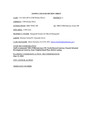
ZONING CHANGE REVIEW SHEET CASE: C14-2024-0074 (2209 Donley Drive) ADDRESS: 2209 Donley Drive ZONING FROM: NBG-WMU-NP TO: NBG-TOD(Gateway Zone)-NP SITE AREA: 2.899 acres DISTRICT: 4 PROPERTY OWNER: Marquardt Family LP (David Marquardt) AGENT: Drenner Group PC (Amanda Swor) CASE MANAGER: Sherri Sirwaitis (512-974-3057, sherri.sirwaitis@austintexas.gov) STAFF RECOMMENDATION: Staff recommends NBG-TOD(Gateway)-NP, North Burnet/Gateway-Transit Oriented Development-Gateway Zone-Neighborhood Plan, district zoning. PLANNING COMMISSION ACTION / RECOMMENDATION: June 11, 2024 CITY COUNCIL ACTION: ORDINANCE NUMBER: C14-2024-0074 ISSUES: N/A CASE MANAGER COMMENTS: 2 The property in question is a 2.9 acre lot that is developed with a 25,664 square foot office/warehouse multi-tenant small bay building (Texas Cool Roofing & Waterproofing, Blue Sky Scrubs, LLC, Nova Tuff Coatings). To the east, there is another office/warehouse (Metric Center), a surface parking area and a three-story office building (Innovation Park) that were recently rezoned to NBG-TOD(Gateway Zone)-NP. The lot to the west is zoned NBG-WMU-NP and is developed with a one-story office/warehouse structure. To the north, across Donely Drive, there are lots that are zoned NBG-TOD-NP and NBG-NMU-NP and are developed with one-story offices. To the south, there are one-story industrial warehouses (Denton Center) that are zoned NBG-CI-NP. The site under consideration is within the North Burnet Gateway Neighborhood Planning area and is zoned NBG-WMU-NP, North Burnet Gateway-Warehouse Mixed Use- Neighborhood Plan Combining District. This lot is located on Donely Drive, a level 2/collector roadway, to the east of Missouri Pacific Railroad. The applicant is requesting to rezone the property from NBG-NP (WMU Subdistrict) to NBG-NP (TOD-Gateway Zone Subdistrict) to allow for the development of a residential project with associated ground floor uses. (please see Applicant’s Request Letter-Exhibit C). The TOD subdistrict allows a FAR of 12:1 and a maximum building height of up to 491 feet, with development bonuses (please see the revised North Burnet Gateway - TOD subdistrict General Site Development Standards-Exhibit D). With the development of the Q2 stadium on the former McKalla tract to the west, there has been a transition in the zoning of the properties in this area within the North Burnet Gateway Neighborhood Plan (please see the Area Case Histories table below). Gateway zones are connected to the designated Transit Corridors and allow for greater height and density in close proximity to rail stations, such as the new McKalla Rail Station, which opened on February 24, 2024 to coincide with the kick-off of the fourth season for Austin FC. Therefore, the staff is recommending North Burnet Gateway-Neighborhood Plan (TOD- Gateway Zone Subdistrict) zoning for this property because the proposed zoning will be compatible with the continued redevelopment patterns in this area around Q2 stadium. The NBG-NP (TOD Gateway) subdistrict zoning is appropriate at this location because it is consistent with the NBG-TOD-NP zoning to the north and east. This property will be within walking distance of the proposed Red-Line Trail to the west that will provide pedestrian and bike paths that will connect to the new regional rail station. McKalla Station features daily operations including special game day trips as well as a double track design, two passenger platforms and expanded walking and bike paths connecting to the stadium and surrounding neighborhood. Therefore, the staff’s recommendation will permit uses and site development standards to the northeast of Q2 Stadium on Donely Drive that will allow for redevelopment to permit new commercial and residential uses. The applicant agrees with the staff’s recommendation. C14-2024-0074 3 BASIS OF RECOMMENDATION: 1. The proposed zoning should be consistent with the purpose statement of the district sought. North Burnet/Gateway district is the designation for an identified area of existing low density, auto oriented commercial, warehouse, and industrial uses that is the subject of an approved master plan for redevelopment of the area into a higher density urban mixed use neighborhood that is more pedestrian friendly and takes advantage of the links to commuter rail transit and the area’s key position in the urban core. Transit-Oriented Development (TOD) is the highest density subdistrict in the North Burnet/Gateway area with the greatest focus on providing active pedestrian-oriented uses at the ground level of buildings. Density is enabled to the highest degree in the “TOD- Gateway area” closest to the rail station and to a lesser degree elsewhere. Within the TOD Subdistrict certain areas are identified as active edges on the NBG Subdistrict Map. An active edge designation imposes additional specific land use and design requirements for development at visible intersections and along key streets that lead to the rail station. Neighborhood Plan district denotes a tract located within the boundaries of an adopted Neighborhood Plan. 2. The proposed zoning should promote consistency and orderly planning. The staff recommends the NBG-NP (TOD Gateway Zone) district because it is consistent with the NBG-NP (TOD) subdistrict zoning directly to the east and to the north across Donely Drive. The subject property is located within the boundaries of a “Regional Center” as designated on the Growth Concept Map in the Imagine Austin Comprehensive Plan. 3. The proposed zoning should allow for a reasonable use of the property. The NBG-TOD(Gateway Zone)-NP zoning district would allow for a fair and reasonable use of the site. The proposed TOD(Gateway Zone) subdistrict will allow for high-density residential and commercial uses, which will provide desirable housing opportunities and additional services for the people that work in the surrounding office, commercial and industrial areas. This site is located near major employment, commercial and residential developments such as The Domain, J.J. Pickle Research Campus, IBM-Broadmoor Campus, Charles Schwab complex, etc. and a large outdoor entertainment use (Q2 Stadium). It is within the vicinity of the new McKalla Station adjacent to Q2 Stadium, near Delta Drive, on the MetroRail Red Line approximately 850 feet south of Braker Lane. C14-2024-0074 4 This property has access to all modes of transportation within walking distance. The new McKalla Rail Station is located to the west and the associated Redline trail will provide pedestrian and bicycle access north and south. With a pedestrian crossing connecting McKalla Station to Delta Drive, the property is a 0.3 mile walk to the new transit station. EXISTING ZONING AND LAND USES: Site North South East West ZONING NBG-NP (North Burnet/Gateway-Warehouse- Mixed Use Subdistrict- Neighborhood Plan) NBG-NP (North Burnet/Gateway-Transit Oriented Development Subdistrict-Neighborhood Plan) NBG-NP (North Burnet/Gateway-Commercial- Mixed Use Subdistrict- Neighborhood Plan), NBG-NP (Commercial Industrial Subdistrict- Neighborhood Plan) NBG-NP (North Burnet/Gateway- TOD(Gateway Zone) Subdistrict-Neighborhood Plan) NBG-NP (North Burnet/Gateway-Warehouse- Mixed Use Subdistrict- Neighborhood Plan) LAND USES Office/Warehouse (Texas Cool Roofing & Waterproofing, Blue Sky Scrubs, LLC, Nova Tuff Coatings) 1-Story Office/Warehouses Multifamily (Broadstone North ATX), 1-Story Industrial Warehouses (Denton Center) Office/Warehouse (Metric Center), Surface Parking Area, 3-Story Office Building (Innovation Park) 1-Story Office/Warehouses (Lux Art Consulting, Run Lab, Hyperion International Tech, IPEX) NEIGHBORHOOD PLANNING AREA: North Burnet/Gateway Neighborhood Plan Area WATERSHED: Little Walnut Creek SCHOOLS: Austin I.S.D. Katherine A. Cook Elementary School Padron Elementary School BASIS Austin Burnet Middle School Anderson High School C14-2024-0074 5 NEIGHBORHOOD ORGANIZATIONS: Austin Independent School District, Austin Lost and Found Pets, Austin Neighborhoods Council, Friends of Austin Neighborhoods, Homeless Neighborhood Association, Neighborhood Empowerment Foundation, North Burnet/Gateway Neighborhood Plan Staff Liaison, North Growth Corridor Alliance, SELTexas, Shoal Creek Conservancy, Sierra Club, Austin Regional Group AREA CASE HISTORIES: NUMBER C14-2023-0149 (Donely NBG Rezoning: 2101, 2105, 2111 and 2201 Donley Drive) NBG-WMU-NP to NBG-TOD (Gateway Zone)-NP REQUEST 2/13/2024: Approved staff's recommendation of NBG- TOD(Gateway)-NP zoning by consent (12-0); A. Azhar-1st, F. Maxwell-2nd. COMMISSION CITY COUNCIL 3/21/2024: The public hearing was conducted and a motion to close the public hearing and approve Ordinance No. 20240321-050 for North Burnet/Gateway-neighborhood plan (NBG-NP) combining district zoning (transit-oriented development-gateway zone) was approved on Council Member Qadri’s motion, Council Member Ryan Alter’s second on an 11-0 vote. 3/21/2024: The public hearing was conducted and a motion to close the public hearing and approve Ordinance No. 20240321-049 for North Burnet/Gateway-neighborhood plan (NBG-NP) combining district zoning (transit oriented development-gateway zone subdistrict) was approved on Council Member Qadri’s motion, Council Member Ryan Alter’s second on an 11-0 vote. 1/18/24: Approved staff’s rec. of NBG-TOD (Gateway)-NP zoning by consent (11-0); Z. Qadri-1st, P. Ellis-2nd. C14-2023-0150 (Kramer NBG Rezoning: 2111 & 2115 Kramer Lane; 2106 1/2 Donley Drive) NBG-NMU-NP to NBG-TOD (Gateway Zone)-NP 2/13/24: Approved staff's recommendation of NBG- TOD(Gateway)-NP zoning by consent (12-0); A. Azhar-1st, F. Maxwell. C14-2023-0040 (10317 - 10423 McKalla Place) NBG-WMU-NP to NBG-TOD (Gateway Zone)-NP 12/12/23: Approved the staff's recommendation of NBG-TOD (Gateway)-NP zoning by consent (12-0, P. Howard- absent); F. Maxwell-1st, A. Azhar-2nd. C14-2024-0074 6 C14-2023-0045 (2404 Rutland Drive) NBG-WMU-NP to NBG-CMU (Gateway Zone)-NP 9/12/23: Approved the applicant's request for NBG- CMU (Gateway Zone)-NP zoning (9-1-1, J. Mushtaler-No, G. Cox-abstain) 10/19/23: Postponed to November 2, 2023 at the applicant's request by consent (10-0, N. Harper- Madison-absent); P. Ellis-1st, L. Pool-2nd. 11/02/2023: Postponed to November 30, 2023 at the applicant's request by consent (9-0, M. Kelly-off the dais, N. Harper-Madison- absent); Z. Qadri-1st, J. Velasquez-2nd. 11/30/2023: Approved NBG- CMU(Gateway Zone)-NP zoning by consent on all 3 readings (10-0, R. Alter-off the dais); N. Harper-Madison-1st, P. Ellis-2nd. 6/09/22: Approved NBG-CMU (Gateway Zone)-NP zoning by consent on all 3 readings (11-0); N. Harper-Madison-1st, P. Renteria-2nd. 9/30/21: The public hearing was conducted and a motion to close the public hearing and approve NBG-CMU-Gateway Zone-NP district zoning ( was approved on Council Member Renteria's motion, Council Member Ellis' second on an 11-0 vote. February 4, 2021: The public hearing was conducted and a motion to close the public hearing and approve Ordinance No. 20210204-058 for public (P) district zoning was approved on Council Member Pool's motion, Council Member Tovo's second on an 11-0 vote. 6/06/19: The public hearing was conducted and a motion to close the public hearing and approve Ordinance 20190606-097 for C14-2022-0045 (10321 and 10401 Burnet Road) NBG-CMU-NP to NBG-CMU (Gateway Zone)-NP NBG-CMU-NP to NBG-CMU (Gateway Zone)-NP 5/10/22: Approved staff's recommendation of NBG- CMU (Gateway Zone)-NP zoning by consent (13-0); A. Azhar-1st, J. Mushtaler-2nd. 8/24/21: Approved staff's recommendation for NBG- CMU(Gateway)-NP zoning by consent (11-0); C. Hempel-1st, R. Schneider - 2nd. NBG-TOD-NP to P 1/26/21: Approved staff’s recommendation of P district zoning (12-0, A. Azhar-1st, P. Seeger-2nd. C14-2021-0101 (Verde Square: 10401 1/2, 10431, 10435, 10505, and 10509 Burnet Road) C14-2020-0128 (NBG Austin Energy Substation Rezoning: 2412 Kramer Lane) C14-2019-0055 (Austin FC: 10414 McKalla LI-NP, NBG-NP to LI-PDA-NP 5/14/19: To approve the staff’s recommendation of LI-PDA zoning, with added condition to approve the Transportation C14-2024-0074 7 Impact Analysis (TIA) with the site plan process, if practical (Vote: 11-2, K. McGraw and P. Seeger-No); G. Anderson-1st, C. Kenny- 2nd. 8/0916: Approved staff’s recommendation of MI-PDA zoning on consent (8-0, K. McGraw, S. Oliver, P. Seeger, J. Thompson, T. White-absent); N. Zaragoza-1st, J. Shieh-2nd. 5/27/14: Approved staff’s recommendation for MI-PDA zoning by consent (8-0, J. Nortey-absent); R. Hattfield- 1st, N. Zaragoza-2nd. 11/12/13: Approved staff’s recommendation for MI-PDA zoning, with conditions for a limitation of 90,000 square feet of Cocktail Lounge use as permitted with no one user exceeding 13,000 sq. ft. within the designated 43.267acre area (outlined in Exhibit A) located within the Property., by consent (7-0-2, D. Chimenti and A. Hernandez-absent); J. Nortey-1st, B. Roark-2nd. 5/08/12: Approved MI-PDA zoning by consent (9-0); D. Anderson-1st, S. Kirk-2nd. limited industrial services- planned development area- neighborhood plan (LI-PDA- NP) combining district zoning was approved on Council Member Pool’s motion, Council Member Flannigan’s second on a 10-0 vote. Council Member Harper-Madison was absent. 9/22/16: The public hearing was conducted and a motion to close the public hearing and approve Ordinance No. 20160922-071 for MI-PDA zoning, to change a condition zoning was approved on consent on Council Member Houston’s motion, Council Member Casar’s second on a 10-0 vote. Council Member Troxclair was absent. 6/26/14: Approved MI-PDA zoning, to change a condition of zoning, on consent on all 3 readings (6-0, M. Martinez- off the dais); B. Spelman-1st, S. Cole-2nd. 12/12/13: Approved MI-PDA zoning on consent on all 3 readings (7-0); B. Spelman-1st, S. Cole-2nd. of 6/28/12: Approved MI-PDA zoning to change a condition of zoning on all 3 readings (7-0); C. Riley-1st, S. Cole-2nd. Place and 10617 ½ Burnet Road) C14-2016-0074 (Element Hotel: 10728 Burnet Road) MI-PDA to MI-PDA MI-PDA to MI- PDA MI-PDA to MI- PDA C14-2014-0062 (The Kenzie: 3201 Esperanza Crossing) C14-2013-0130 (Domain Entertainment District: 11824 Burnet Road) C14-2012-0002 (The Domain: 10728-11306 and 11500-11900 Burnet Road; 3300 West Braker Lane; 11105 and 11401-11925 Domain Drive, and 2900-3210 MI-PDA to MI-PDA: To amend the PDA 1) To allow for a Cocktail Lounge use as a permitted use on a 2,198 sq. ft. parcel and 2) C14-2024-0074 8 To relocate 1- acre of designated zero impervious area within a nine acre park to a new location within the same park. MI-PDA to MI-PDA: To amend the Domain zoning ordinance to request a change to the PDA overlay to allow 83% impervious cover for the overall site. Esperanza Crossing) C14-2010-0087 (The Domain Rezoning-Simon: 11701, 11733 North Mopac Expressway; 11400, 11500 Domain Drive; 3311 Rogers Road; 3409 Esperanza Crossing; 11600 Century Oaks Terrace) 8/24/10: Approved staff’s recommendation of MI-PDA zoning with the condition that the applicant agree to a public restrictive covenant to limit one acre of land on the Endeavor- Domain site to zero percent impervious cover to offset the increase in impervious cover on the Simon-Domain property (8-1, Chimenti-No), with the following additional conditions: 1) Require the applicant to provide bicycle access for a portion Bicycle Route Segment #905.04 (Please see Public Works Department Memorandum – “Attachment B”) to allow for continuity for bicycle traffic to and through the Domain development. 2) Require a public restrictive covenant that will limit one acre of land on the Endeavor- Domain site to zero percent impervious cover to be signed and recorded before the 3rd reading of this zoning case at City Council. 8/26/10: The public hearing will remain open and the first reading of the case was approved for MI-PDA zoning (7-0); Morrison-1st, Spelman- 2nd, with the following additional conditions: 1) The applicant is to provide bicycle access for a portion of Bicycle Route Segment #905.04 to allow for continuity for bicycle traffic to and through the Domain development. 2) A public restrictive covenant that will limit one acre of land on the Endeavor- Domain site to zero percent impervious cover will be signed and recorded before the third reading of this zoning case. 10/14/10: Approved MI-PDA zoning on2nd/3rd readings (7-0); Spelman-1st, Leffingwell-2nd, with the following amendments: 1) Part 3, C, 1 of the ordinance should read: “A pedestrian/bicycle entrance shall be provided between the existing pedestrian/bicycle trail under Mopac Expressway and the Simon Project internal drive as shown on the attached Exhibit B. A minimum 12-foot wide paved path shall be constructed with an associated curb cut connecting to the internal drive prior to issuance of a certificate of occupancy for a building on Lot 5A, Block A, the Domain Shopping Center C14-2024-0074 9 Section 3 Subdivision.”; 2) Add a new paragraph to Part 3, Section D to read: “The two trees on the property numbered 5068 and 5081 as shown on Exhibit D may not be removed, unless the City Arborist approved otherwise based on the health of the individual trees.”; 3) The approved otherwise based on fourth WHERAS of the restrictive covenant should read: “WHEREAS, the requirements of the Land Development Code for both the Endeavor Tract and the Simon Tract allow for a combined maximum of eighty percent (80%) net site area impervious cover resulting in a total allowable impervious cover area of 135.36 acres for the Endeavor Tract and 40.54 for the Simon Tract; and”. 10/14/10: Approved MI-PDA zoning on all 3 readings on consent (7-0); Spelman-1st, Cole-2nd, with the following conditions: 1) Part 3, C, 1 of the ordinance should read: “The Domain-Endeavor Project shall provide internal bicycle routes for access and continuity to existing or planned bicycle routes as well as multi-use hike and bike trails as more particularly detailed in the attached Exhibit C.”, 2) Part 3, C, 4 of the ordinance should read: “The sharrows shall be installed within one year of the effective date of this ordinance for existing roadways and at the time of construction for future roadways.” C14-2010-0015 (The Domain Rezoning- Endeavor: 10712, 10728, 10800, 11000, 11500, 11600 Burnet Road; 11601 Domain Drive; 2900, 3001, 3101 Esperanza Crossing) To rezone the property from MI- PDA to MI-PDA to amend the Domain zoning ordinance to modify the following conditions: 1)To provide updated bike lanes for the development by routing sharrows and hike and bike paths throughout the site 2) To request a variance through the PDA to LDC Sec. 25-2-813 to allow an administrative approval of one large retail user exceeding 100,000 square feet to be constructed on the portion of the Domain property that is located north 8/24/10: Approved staff’s recommendation for MI-PDA zoning (8-1, Tovo-No), with an amendment to the Public Works Department Memorandum – “Attachment A” to change the wording in the first line of item #2 from should to shall. The Commission also included findings for the justification for the approval of the proposed variance to the “Big Box” ordinance, LDC Sec. 25-2-813: 1) This request is a special circumstance because the property is located with a PDA overlay district. 2) This approval is in accordance with the North Burnett/Gateway Neighborhood Plan. 3) The approval for this case allows for the inclusion of the recommendations of C14-2024-0074 10 of Esperanza Crossing. Thereby, removing the requirement to secure approval of a Conditional Use Permit for this sole large retail user at this location. MI-PDA to MI- PDA C14-06-0121 3/01/07: Approved MI-PDA zoning with the addition of low albedo roofing materials, one star construction for the total site and two star construction for 50% of the office and residential construction (7-0); McCracken-1st, Dunkerley-2nd. the City of Austin Bicycle Program for the property. 2/13/10: Approved staff’s rec. for MI-PDA zoning with additional conditions of: • 2 star Green Building rating • natural landscaping of all water quality ponds (existing and future); • be in compliance with • applicant’s parkland TIA conditions; the requested dedication proposal; • height base of 140-ft; plus an additional 12- based stories on to provide electing some of the public benefits as listed in the North Burnet/Gateway Neighborhood Plan. • Maximum height of 308 feet. Vote: (9-0); J.Reddy-1st, G. Stegeman-2nd. 8/08/06: Approved staff rec. of MI-PDA by consent (8-0) C14-06-0154 MI-PDA to MI- PDA C14-04-0151 MI-PDA to MI- PDA C14-04-0146 P to CH C14-03-0017 MI-PDA to MI-PDA 11/23/04: Approved staff recommendation of MI-PDA, with Environmental Board conditions (9-0). 11/9/04: Approved staff’s recommendation of CH zoning with conditions (9-0) 6/11/03: Approved staff’s recommendation of MI-PDA zoning, with inclusion of 09/28/06: Approved MI-PDA (7-0); 1st reading 10/05/06: Approved MI-PDA changes as a condition of zoning (6-0); 2nd/3rd readings 12/16/04: Approved MI-PDA (7-0); all 3 readings 12/2/04: Approved CH zoning (7-0); all 3 readings 7/31/03: Granted MI-PDA on all 3 readings (7-0) C14-2024-0074 11 C14-03-0016 MI to MI-PDA C14-03-0015 MI to CS C14-02-0062 LI to CS-1 C14H-00-2177 LI-PDA to LI-PDA C14-00-2065 MI to MI-PDA 7/31/03: Granted MI-PDA on all 3 readings (7-0) 7/31/03: Granted CS-CO on all 3 readings 7/11/02: Approved PC rec. of CS-1 (7-0); all 3 readings 11/30/00: Approved LI-PDA (TR1) and LI-PDA-H (TR2); (7-0); all 3 readings 6/8/00: Approved MI-PDA, with changes agreed to with neighborhood association (7-0); all 3 readings original PDA conditions (as read into the record) from Ordinance #000608-67 (8-0, R. Pratt-off dais) 6/11/03: Approved staff's recommendation of MI-PDA zoning (8-0, R. Pratt-off dais) 6/11/03: Approved staff's recommendation of CS-CO zoning (8-0, R. Pratt-off dais) 6/12/02: Approved CS-1 by consent (8-0) 10/24/00: Approved staff rec. of LI-PDA (TR1), LI-PDA-H (TR2) by consent (9-0) 5/9/00: Approved staff rec. of MI-PDA by consent (8-0); with the following conditions: 1) That minimum lot size be 1 acre provided for any lots that directly abut Braker Lane and Burnet Road (but not both) and which are less than 3 acres in size. 2) The total number of additional curb cuts on Braker Lane & Burnet Road providing access to such lots shall not exceed 50 % of the total number of such lots. limitation shall not apply to any lot of more than 3 acres, which abut Braker Lane and Burnet Road. 3) The foregoing RELATED CASES: C14-2018-0182 (North Burnet/Gateway NP Rezonings) C8S-73-196 (Subdivision Case) OTHER STAFF COMMENTS: C14-2024-0074 12 Comprehensive Planning The subject property located at 2209 Donley Drive is currently the site of a warehouse use on 2.89 acres. The site is within a Transit Oriented Development (TOD) zone and adjacent to the NBG TOD Gateway zoning district intended to provide the highest density of active pedestrian-oriented ground- level uses near the rail station. A new NBG Pedestrian Priority Collector is shown adjacent to the site in Figure 1-3: NBG Zoning District Roadway Types Map and shown as required in Figure 3-12 NBG Zoning District Collector Street Plan. It appears existing zoning capacity established in the NBG Master and Regulating Plans, most notably around the TOD zones, were not ambitious enough to allow the subject property and others like it to respond to market forces which desire to fulfill the intent of the NBG plan through the creation of transit-supportive, higher-density mix of uses. The zoning request appears to be consistent with the intent of the North Burnet Gateway Master Plan as well as urban planning and design best practices primarily by increasing intensity and density of a mix of land uses in the urban core around a transit corridor/stop for the city’s only operational rail line. NBG Master Plan: “STATION AREA/TRANSIT-ORIENTED DEVELOPMENT (TOD) Within the Commercial Mixed Use subdistrict, greater density and building heights of up to 30 stories would be allowed and encouraged on properties located within a 1/4 mile of any rail transit station. This distance is recommended as roughly a 5 to 10 minute walk from potential developments to any proposed rail station. In these areas, density will be allowed to step up significantly in return for specific public benefit bonuses within the development…” p79 NBG MP “1. Provide zoning entitlements that allow high density housing developments in the North Burnet/Gateway area (see “Land Use and Zoning” section of this chapter), to increase the supply of housing in Austin and begin to accommodate some of the housing demand that will be generated from expected population growth in the region. 2. Encourage high density housing in close proximity to transit to help reduce vehicle dependency.” p94 NBG MP 2209 Donley Drive Zoning Land Use Base Height Base FAR Development Bonus Current NBG-NP Warehouse Mixed Use (WMU) (Figure 1-2) Warehouse 60 feet (Figure 4-4) 1:1 (Figure 4-2) Maximum Height: 120 feet (Figure 4-5) Maximum FAR: 3:1 (Figure 4-3) Request NBG-NP TOD Gateway Mixed-Use In accordance with Figure 4-4 In accordance with Figure 4-2 Maximum Height: 491 feet Maximum FAR: 12:1 C14-2024-0074 13 Building Setbacks Interior Side Yard: 0’ Rear Yard: 0’ Interior Side Yard: 0’ Rear Yard: 0’ Maximum Impervious Cover 80% in accordance with Figure 4- 6 or maximum allowed by LDC 25-8 80% in accordance with Figure 4- 6 or maximum allowed by LDC 25-8 N/A Compatibility Standards N/A Active Edge Adjacent Street Types Future Streets Active Edge (Figure 1-2) = no Roadway type (Figure 1-3) = Donley Drive is a NBG Urban Roadway existing street. Proposed street (See Figure 1-3 and Figure 3-12) = Yes. A new NBG Pedestrian Priority Collector is shown as required along the eastern property boundary. N/A Roadway type (Figure 1-3) = Donley Drive is a NBG Urban Roadway existing street. Proposed street (See Figure 1-3 and Figure 3-12) = Yes. A new NBG Pedestrian Priority Collector is shown as required along the eastern property boundary. Environmental The site is not located over the Edwards Aquifer Recharge Zone. The site is located in the Little Walnut Creek Watershed of the Colorado River Basin, which is classified as an Urban Watershed by Chapter 25-8 of the City's Land Development Code. It is in the Desired Development Zone. Zoning district impervious cover limits apply in the Urban Watershed classification. According to floodplain maps there is no floodplain within or adjacent to the project location. Standard landscaping and tree protection will be required in accordance with LDC 25-2 and 25-8 for all development and/or redevelopment. At this time, site specific information is unavailable regarding vegetation, areas of steep slope, or other environmental features such as bluffs, springs, canyon rimrock, caves, sinkholes, and wetlands. This site is required to provide on-site water quality controls (or payment in lieu of) for all development and/or redevelopment when 8,000 sq. ft. cumulative is exceeded, and on-site control for the two-year storm. C14-2024-0074 14 At this time, no information has been provided as to whether this property has any preexisting approvals that preempt current water quality or Code requirements. Fire No comments. Parks and Recreation Residential units that are certified affordable under the SMART Housing Policy are exempt from the parkland dedication requirements per City Code § 25-1-601(D). Parkland dedication will be required for any new market-rate residential units that may be proposed by this development, multifamily with GR-MU-V zoning, at the time of subdivision or site plan, per City Code § 25-1-601. If the applicant wishes to discuss parkland dedication requirements in advance of site plan or subdivision applications, please contact this reviewer: thomas.rowlinson@austintexas.gov. At the applicant’s request, PARD can provide an early determination of parkland dedication requirements. Site Plan Site plans will be required for any new development other than single-family or duplex residential. Any development which occurs in an SF-6 or less restrictive zoning district which is located 540-feet or less from property in an SF-5 or more restrictive zoning district will be subject to compatibility development regulations. Any new development is subject to Subchapter E. Design Standards and Mixed Use. Additional comments will be made when the site plan is submitted. Compatibility Standards The site is subject to compatibility standards. Along the North, East, and West property line, the following standards apply: • No structure may be built within 25 feet of the property line. • No structure in excess of two stories or 30 feet in height may be constructed within 50 • No structure in excess of three stories or 40 feet in height may be constructed within feet of the property line. 100 feet of the property line. • No parking or driveways are allowed within 24 feet of the property line. • A landscape area at least 25 feet wide is required along the property line. In addition, a fence, berm, or dense vegetation must be provided to screen adjoining properties from views of parking, mechanical equipment, storage, and refuse collection. C14-2024-0074 15 • For a structure more than 100 feet but not more than 300 feet from property zoned SF-5 or more restrictive, 40 feet plus one foot for each 10 feet of distance in excess of 100 feet from the property zoned SF-5 or more restrictive. • A landscape area at least 25 feet in width is required along the property line if the tract is zoned LR, GO, GR, L, CS, CS-1, or CH. • An intensive recreational use, including a swimming pool, tennis court, ball court, or playground, may not be constructed 50 feet or less from adjoining SF-3 property. • Additional design regulations will be enforced at the time a site plan is submitted. FYI- This site is in the North Lamar Neighborhood Plan. Transportation The Austin Strategic Mobility Plan (ASMP) calls for 116 feet of right-of-way for Rundberg Ln. It is recommended that 58 feet of right-of-way from the existing centerline should be dedicated with the first subdivision or site plan application. [LDC 25-6-51 and 25-6-55]. The adjacent street characteristics table is provided below: Name ASMP Classification ASMP Required ROW Existing ROW Existing Pavement Sidewalks Bicycle Route Capital Metro (within ¼ mile) Rundberg Ln Level 3 116’ 87’ 66’ no Yes Yes, on north side Water Utility No comments on zoning change. FYI: The landowner intends to serve the site with existing City of Austin water utilities. Based on current public infrastructure configurations, it appears that service extension requests (SER) will be required to provide service to this lot. For more information pertaining to the Service Extension Request process and submittal requirements contact the Austin Water SER team at ser@austintexas.gov. C14-2024-0074 16 INDEX OF EXHIBITS TO FOLLOW A. Zoning Case Map B. Applicant’s Request Letter C. North Burnet/Gateway Regulating Plan – WMU Subdistrict and TOD Subdistrict General Site Development Standards NBG-NP C14-2008-0182 SP93-0076C 73-253 OFFICE/WAREHOUSE NBG-NP SERVICE CENTER P C14-2020-0128 O F FIC E/ W A R E H O U S E V E C R I C T A E B RZ85-062 EXHIBIT A C14-2008-0182 NBG-NP 85 -1 4 9 BR OCKTON DR OFFICE/WAREHOUSE SP-94-0443C SP97-0360C SP-96-0198C SP-03-0130C C14-2008-0182 OFFICE NBG-NP SP97-0237C SP97-0237C W BRAKER LN OFFICE/WHSE. BUSINESS PARK T S R A L I U G A NBG-NP C14-2008-0182 760506-B SP-98-0026C ! ! ! ! ! ! ! ! ! ! ! ! ! ! ! ! ! ! ! ! ! ! ! ! ! ! ! ! ! ! ! ! C14-2008-0182 SP94-0369 NBG-NP ! ! ! L A P L L A C K M ! ! ! NBG-NP ! ! ! ! 76-1202-D 73-253 73-161 751218-G ± SUBJECT TRACT ! ! ! ! ! ! PENDING CASE ZONING BOUNDARY SP97-0463C SP-94-0202C OFFICE/WAREHOUSE 84-087 NBG-NP C14-2008-0182 SP97-0199C NBG-NP C14-2008-0182 75-35 SP97-0199C 84-087 R E T N E R C E K A R B LI 78-85 ! ! ! ! ! ! ! ! ! SP93-0163C OFFICES ! ! ! ! ! ! ! WAREHOUSE/OFFICE ! ! ! ! ! ! ! ! ! ! D O ! NLE ! Y D ! R ! ! ! ! ! ! ! ! ! ! ! ! ! ! ! ! ! ! ! ! ! ! SP-97-0132C ! ! ! ! ! ! 2008-0182 ! ! ! ! ! ! ! ! K R A M E R LN ! ! ! ! OFFICES ! ! ! ! ! ! ! ! ! ! SP95-0235C ! ! ! ! ! ! ! ! ! ! FINANCE OFFICE SP87-033 ! ! ! ! OFFICES R O C O. O FIN G 73-63 SP-06-0792CS ! ! ! ! ! ! ! ! ! ! P83-37 ! ! !! C 0 6 1 0 - 9 9 - P S R D A T L E D 73-161 761014-M D E N T O N D R V A C A N T EL E C T RIC M A C C O. HIN E D LV RIC B T E M 01-0037 78-026 SP97-0392C SP-99-2215C LI-NP C14-01-0037 D AY C A R E O F FIC E C14-2008-0182 NBG-NP SP93-0342C R D N A IT L O P O R T E M E N E R G Y D R NBG-NP S E FFIC O W H S E B O Y E LI-NP R BLV D 73-161 WHSE OFFICE ZONING 01-0037 ( ( MF-3-NP ( ( ( ( ZONING CASE#: C14-2024-0074 BUSINESS PARK LI-PDA-NP C14-2019-0055 NBG-NP ! ! ! C14-2008-0182 ! ! ! ! This product is for informational purposes and may not have been prepared for or be suitable for legal, engineering, or surveying purposes. It does not represent an on-the-ground survey and represents only the approximate relative location of property boundaries. 1 " = 400 ' This product has been produced by the Planning Department for the sole purpose of geographic reference. No warranty is made by the City of Austin regarding specific accuracy or completeness. Created: 5/6/2024 EXHIBIT B Amanda Swor dial: (512) 807-2904 aswor@drennergroup.com Ms. Lauren Middleton-Pratt Housing and Planning Department City of Austin 6310 Wilhelmina Delco Dr. Austin, TX 78752 April 24, 2024 Via Electronic Delivery Re: 2209 Donley Drive – Rezoning application for the approximately 2.899-acre piece of property located at 2209 Donley Drive in the City of Austin, Travis County, Texas (the “Property”). Dear Ms. Middleton-Pratt: As representatives of the owner of the Property, we respectfully submit the enclosed rezoning application package. The project is titled 2209 Donley Drive and is approximately 2.899 acres of land, located at 2209 Donley Drive. The Property is in the full purpose jurisdiction of the City of Austin. The Property is currently zoned NBG-NP, North Burnet/Gateway – Neighborhood Plan, district, and is more specifically located in the Warehouse Mixed Use (“WMU”) subdistrict of the North Burnet Gateway (“NBG”) Regulating Plan. The requested rezoning is from the WMU subdistrict to the TOD-Gateway, Transit Oriented Development – Gateway, subdistrict. The Property is currently developed with warehouse uses. The purpose of the rezoning is to allow for the development of a residential project with associated ground floor uses. This request is consistent with proposed uses surrounding Q2 Stadium and in the surrounding area. The proposed development will comply with site development and design standards established in the NBG Regulating Plan. This rezoning also proposes to amend three (3) maps within the NBG Regulating Plan. Firstly, Figure 1-2 (North Burnet / Gateway Zoning District Subdistrict Map) is proposed to be amended to designate the Property as within the TOD Gateway Zone. Secondly, Figure 4-3 (Maximum Floor-to-Area-Ratio with Development Bonus) is proposed to be amended to allow for a 12:1 Maximum Floor-to-Area Ratio on the Property. Lastly, Figure 4-5 (Maximum Height with 2705 Bee Cave Road Suite 100 | Austin, Texas 78746 | 512-807-2900 | www.drennergroup.com P a g e | 2 Development Bonus) is proposed to be amended to allow for a maximum height of 491 feet with a development bonus on the Property. The Property is located within the NBG Neighborhood Planning Area. The Neighborhood Plan was adopted November 1, 2007 and designates the Property as High Density Mixed Use in the future land use map. A memorandum from Maureen Meredith dated April 23, 2024 is attached and confirms that a Neighborhood Plan Amendment application is not required with this zoning application. The Traffic Impact Analysis ("TIA") is not required per the attached TIA Determination Form dated April 23, 2024 and executed by Mustafa Wali as the traffic generated by the proposed development does not exceed the thresholds established in the Land Development Code. Please let me know if you or your team members require additional information or have any questions. Thank you for your time and attention to this project. Very Truly Yours, Amanda Swor cc: Joi Harden, Housing and Planning Department (via electronic delivery) 2705 Bee Cave Road, Suite 100 | Austin, Texas 78746 | 512-807-2900 | www.drennergroup.com EXHIBIT C Exhibit "A" Revised 08-04-22 ?-4 141 // i l 13--1 , 1 jks.. /X UJ 5 1 --%--2? L_bti#q 94 4% 0,5='94 41[TM t.- -£-11 04 1 tV E-' --1=5*14 -f- -t*IN?g l NER 428+ 2, 421*14 Tl- %__93941 727.0--, --7 --*f 1. 1 Figure 1-2: North Burnet / Gateway (NBG) Zoning District Subdistrio Mop LEGEND NBG Subdistricts : ? Transit - Oriented Development (TOD / TOD Midway) N d 5*2?34. ₫,Q[lgta':302?*:EWR??)4? 4899?34@fl?? u BulImlitti@ Mmiff?FrE - i t·+44UIERTN %44446#Fmu., rTT?rrUIDI[mION 97« iRMIL- \46-4\1 -- \ A-t / ' 1 [ITTTY) j :CU?9O.UVAL,." A 11- f ₫z)-1. -7- . , r- -'4 A V-- 4 4 34 .... ... .... ? TOD - Gateway Zone ? Commercial Mixed - Use (CMU) ... : CMU - Midway Zone 23 CMU . Gotewoy Zone ? Neighborhood Mixed Use (NMU) Neighborhood Residential (NR) Warehouse Mixed Use (WMU) 5* Commercial Industrial (Cl) - Active Edges - -NBG Planning Areo Boundary Parcel Boundary - Railroads 77 i-loof°fr '. 0?EFLA???2.<414??3?2,41 FT.-277_111.01111%fri 91 f- / L- 9LJ -C=ILH/// \ *C--3, f // -2 le&- i1/ ) 1 ? Ok-i--g f 7 I ti 21·17 14 i 4_I> f 1 0 \11 h Ul Z d D S 2 1.-... j 1 1 -1 -*--/ r \\ 9 \ 1' Ph Wa//////1 BRAKER..?'-/??? -11.11, \ -1-1 1- \ -1 ,2 1 3 r r, j ? ?« I rG k11 ?. Al -? 1 12,4 91\: •••••••••••• U blot••••••• r -?.?41-1 ......... 6«o: C ».................... ,¤2911(1 /6................... . .........1 Z 0 U') 1, \6.... l I ......... -1 "2©9@g I Nr=j-==2-,?ff'x,?tuQR? 7 1 1 49ty,4- _ _ $40 1 L - 1/. A?E ??. »? _?? ..ktihil 1.-, 4-1 1--r=? k»-74!-* 9 E-7©gp.₫₺itm M<>633,28# 121 - _ _1 'tty ' I T<©,et 1 t 121=16-Eiu-- ?UTLAND 1705/M, ; ----i-2 4 --tuot>· JJ-1 -1-04} 1--₫«₫- Id h,#.3 l? ?1 f 4% LT? i.-j P-1 U 1#Ail A- ki ./.1 129 1 © t-L / r 1 11 0 1 11 1_ ..._ l--- - lili . - Emil*«14 #14 tititi-08,--- £ 0 ............... 0••/•••••••••...1 ............ 1 As·I:::t ::::26 ....... ... 1 r _© 9 - - 2\ d»0*2,71*RifI?-ih r J:.?.1 1 - >2-2 13- -' 70€¢14* 4 7-31 ,? TI-1 5& 3?"A< 0-4 <v 161. Al U L 3411#9)11)13-i ₫74-1_23?r9·,1/i- i :'/i?LM/1₫, -J---L- I -37 7 4 1 -2*,ke==a - - /2- 1-/-233-1 -f -4[zoi/Ff-70·*il·cji-a LE= ₫47*fij?Oitfjilt497=2 4 .,..l__ 6 ?? NORTH 1 MILE 6 2-?1 M.619.4- - u 12 k 63*6.'r 1»-1 948021 j ? .1 4.--1 ..VIn hf?L-?0? M MO F _ A?G44 -L« h 1101 1 1/7. 1 .1,6, 9 ·7 44 1 .LF 14, f 7 1 1.-7 .... D 10 ACRES 1, f. f I 4 1 1 \ £' L - M i 1 U 0 FIGURE 4-1 WMU : NBG ZONING DISTRICT GENERAL SITE DEVELOPMENT STANDARDS WAREHOUSE MIXED USE (WMU) SUBDISTRICT Exhibit "B" Revised 10-05-23 -&4 FLOORTOAREA RATIO i,,I. Maximum Floor-to-Area Ratio (FAR) by Right: Established on Figure 4-2 (Based on the maximum FAR allowed by the prop- erty's zoning prior to adoption of this Document) Maximum Floor-to-Area Ratio (FAR) with Development Bonus: 3:1 This FAR may be granted in exchange for the provision of public benefits. The development bonus criteria and stan- dards are detailed in Article 6. BUILDING HEIGHT Minimum Building Height: Not applicable Maximum Building Height by Right: Established on Figure 4-4 (Based on the maximum height allowed by the prop- erty's zoning prior to adoption of this Document.) 120 Feet Maximum Building Height with Development Bonus: This building height may be granted in exchange for the provision of public benefits. The development bonus crite- ria and standards are detailed in Article 6. ty * 1 'ta '*1/1 LOT SIZE ia. - Minimum Lot Size 2,500 SF Minimum Lot Width 20 Feet MINIMUM SETBACKS Al",3/ 41*1*4.2 Front Yard and Street Side Yard*: No ground-level front yard or street side yard setbacks are required. development must meet the building placement standards in Section 4.3. Instead, Front and Street Side Upper Story 8#1444**%4*eade·&*epbeele. U The hi,ilrlin,• f.r·irir• it thi, 6th rtnr, inrl nhn„r• milrt hr, ,tnnrwl h.rl. la fe,4 frnmi the ground level building facade line. ll Interior Side Yard: Rear Yard: 0 Feet 0 Feet * If the street right-of-way is less than 60 feet in width, the minimum front yard setback for buildings three or more stories in height shall be 30 feet from the center line of the street to ensure fire access. MAXIMUM IMPERVIOUS COVER If located in an urban watershed (Shoal or Little Walnut Creek): Established on Figure 4-6 (Based on the maximum impervious cover allowed by the property's zoning prior to adoption ofthe this Document.) If located in a suburban watershed (Walnut Creek): Not applicable -30- 5 Stories 120' Max Height with Development Bonus r. g I R 9 1 1 4. 4. .k '1:0, F .lu ...ms-7RRIfir.P).'£ .= A Typical examples of buildings in the Warehouse Mixed Use Subdistrict. FIGURE 4-1 TOD : NBG ZONING DISTRICT GENERAL SITE DEVELOPMENT STANDARDS TRANSIT ORIENTED DEVELOPMENT (TOD) SUBDISTRICT .1 , 54•4*· FLOOR TO AREA RATIO '4*, Maximum Floor-to-Area Ratio (FAR) by Right: Established on Figure 4-2 (Based on the maximum FAR allowed by the prop- erty's zoning prior to adoption ot this Document) Maximum Floor-to-Area Ratio (FAR) with Development Bonus: TOD Gateway Zone TOD Midway Zone 12:1 12:1 This FAR may be granted in exchange for the provision of public benefits. The de- velopment bonus criteria and standards are detailed in Article 6. , 1 1, t. M 4 1 ' 1 Eli f, W Exhibit "B" Revised 10-05-23 BUILDING HEIGHT Minimum Building Height: 2 Stories Maximum Building Height by Right: Established on Figure 4-4 (Based on the maximum height allowed by the prop- erty's zoning prior to adoption of this Document.) Maximum Building Height with Development Bonus* TOD Gateway TOD Midway 491 Feet 491 Feet This building height may be granted in exchange for the provision of public benefits. The development bonus crite- ria and standards are detailed in Article 6 4xception: If adjacent to or across the street from ER subdistrict maximum height is 120 feet. Typical example of buildings in the Transit Oriented Development Subdistrict. 491' Max. ,-leight with Development Bonus (TOD Gateway & TOD Midway) -1,4£W?-4 LOT SIZE,*.d*,I?*2' Minimum Lot Size 2,500 SF Minimum Lot Width 20 Feet 4?& MINIMUM SETBACKS ,?? Front Yard and Street Side Yard*: No ground-level front yard or street side yard setbacks are required. development must meet the building placement standards in Section 4.3. Instead, Front and Street Side Upper Story 8•*4144**g·*eade·&*epheeks. 'the 6-,Irl'1nli firirl, nt tlin *th .tnrir nnrl r, h n. r. rn i i I tho rtnnnAA hird, lA fe·„+ trn'n the ground level building facade line. Interior Side Yard: 0 Feet 11 Rear Yard: 0 Feet If the street right-of-way is less than 60 feet in width, the minimum front yard and street side yard setbacks for build- ings three or more stories in height shall be 30 feet from the center line of the street to ensure fire access. MAXIMUM IMPERVIOUS COVER If located in an urban watershed (Shoal or Little Walnut Creek): Established on Figure 4-6 (Based on the maximum impervious cover allowed by the property's zoning prior to adoption of the this Document.) If located in a suburban watershed (Walnut Creek)*: * This requirement supersedes imper- vious cover requirements of Section 25-8-394(C) of the LDC. 80% r 30 - 5 S-ories **