27 C14-2023-0135 - 1500 & 1600 Royal Crest; District 3 — original pdf
Backup
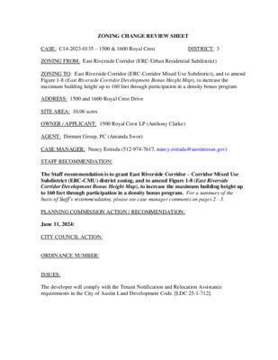
ZONING CHANGE REVIEW SHEET DISTRICT: 3 CASE: C14-2023-0135 – 1500 & 1600 Royal Crest ZONING FROM: East Riverside Corridor (ERC-Urban Residential Subdistrict) ZONING TO: East Riverside Corridor (ERC-Corridor Mixed Use Subdistrict), and to amend Figure 1-8 (East Riverside Corridor Development Bonus Height Map), to increase the maximum building height up to 160 feet through participation in a density bonus program ADDRESS: 1500 and 1600 Royal Crest Drive SITE AREA: 10.06 acres OWNER / APPLICANT: 1500 Royal Crest LP (Anthony Clarke) AGENT: Drenner Group, PC (Amanda Swor) CASE MANAGER: Nancy Estrada (512-974-7617, nancy.estrada@austintexas.gov) STAFF RECOMMENDATION: The Staff recommendation is to grant East Riverside Corridor – Corridor Mixed Use Subdistrict (ERC-CMU) district zoning, and to amend Figure 1-8 (East Riverside Corridor Development Bonus Height Map), to increase the maximum building height up to 160 feet through participation in a density bonus program. For a summary of the basis of Staff’s recommendation, please see case manager comments on pages 2 - 3. PLANNING COMMISSION ACTION / RECOMMENDATION: June 11, 2024: CITY COUNCIL ACTION: ORDINANCE NUMBER: ISSUES: The developer will comply with the Tenant Notification and Relocation Assistance requirements in the City of Austin Land Development Code. [LDC 25-1-712]. C14-2023-0135 Page 2 The applicant held a meeting with the current tenants on May 13, 2024 and provided the following information as proposed Tenant Protection items: • No termination of leases without good cause. • Rental rate + mandatory fees increase by no more than 7.5% per year for a period of 5 years. • 365-day notice of redevelopment provided to tenants. • 180-day notice of demolition. • 90-day move-out notice. • On-site services to help tenants find new housing or other qualified programs. • Ability for tenant to break lease without repercussion once 180-day notice of demolition is • Moving allowance of $3,000 flat payment. • Last three (3) months of rent waived for tenants still in units. • Full refund of security & pet deposits once demo permit is filed. • No unit entry without 48-hour advance notice. • No prevention of activities associated with tenant’s organization. • Right to return - first chance at new units; both affordable (if qualifications are met) and filed. market rate. The items listed are subject to being amended. CASE MANAGER COMMENTS: The subject rezoning area is approximately ten acres and located south of East Riverside Drive and north of Woodland Avenue between Royal Crest Drive and Parker Lane. The property is currently developed with a 3-story building of existing multifamily residences with 286 units. This site is in the East Riverside Corridor (ERC) Regulating Plan within the Urban Residential (UR) subdistrict and is also included in the hub boundary. The (UR) subdistrict allows for buildings up to 40 feet in height which are not eligible for a development bonus. Directly to the east across Royal Crest Drive are multifamily residences (ERC-UR) as well as some commercial uses that are also within the (UR) subdistrict; multifamily and single family residences are to the north and to the west across Parker Lane (MF-2-NP; SF-3-NP); and existing multifamily residences are immediately adjacent to the south with some single family residences (MF-2-NP; SF-3-NP). Please refer to Exhibits A (Zoning Map) and A-1 (Aerial Exhibit). East Riverside Drive is designated as a core transit corridor. Both Royal Crest Drive and Parker Lane are urban roadways from which access is proposed for the future development. Transit along East Riverside Drive is located within one quarter of a mile north of the property. The Applicant is requesting to rezone the property to the Corridor Mixed Use (ERC-CMU) subdistrict and to amend Figure 1-8 (East Riverside Corridor Development Bonus Height Map), to increase the maximum building height up to 160 feet through participation in a density bonus program. Please refer to attached Figures. The requested amendment would C14-2023-0135 Page 3 allow the property to be redeveloped with 1100 multifamily residences at a maximum building height up to 160’. The additional height and density would be in exchange for the provision of community benefits. Staff is recommending the Corridor Mixed Use subdistrict (ERC-CMU) and to amend the bonus height map to increase the maximum building height up to 160 feet through participation in a density bonus program. BASIS OF RECOMMENDATION: 1. The proposed zoning should be consistent with the goals and objectives of the City Council. The East Riverside Corridor Regulating Plan created land use districts to help guide development in accordance with proposed transit improvements. The proposed transit improvements, now known as Project Connect’s Blue Line Project, maintain the same general alignment and transit center alignment as shown in the ERC Regulating Plan. This site is located just south of East Riverside Drive which is identified as a Core Transit Corridor within the ERC. The current CapMetro bus system shows existing MetroBus routes along East Riverside Drive which are less than one quarter of a mile from the property. The Corridor Mixed Use (CMU) subdistrict is the highest intensity district as it relates to density and height. Rezoning this lot to the CMU subdistrict and allowing an amendment to the bonus height map would promote higher density and supports transit development. The majority of this property is located within the proposed Lakeshore neighborhood hub. Based on the information above, Staff believes the proposed rezoning change is supported by the East Riverside Corridor Regulating Plan. EXISTING ZONING AND LAND USES: ZONING LAND USES ERC (UR subdistrict) Multifamily residences (286 units) Multifamily residences Site North ERC (CMU and NR subdistricts) South MF-2; SF-3-NP East West MF-2; SF-3-NP Multifamily residences; Single family residences ERC (UR subdistrict) Multifamily residences; Cocktail lounge; Fuel station Single family residences; Multifamily residences NEIGHBORHOOD PLANNING AREA: East Riverside/Oltorf Combined (Riverside) WATERSHED: Lady Bird Lake – Urban CAPITOL VIEW CORRIDOR: No SCENIC ROADWAY: No C14-2023-0135 Page 4 Travis High School Friends of Austin Neighborhoods, East Austin Conservancy, Pleasant Valley, Preservation Austin, SELTexas, Sierra Club Austin Regional Group, South Central Coalition, South River City Citizens Assn., Homeless Neighborhood Association, Martin Middle School SCHOOLS: Austin Independent School District Sanchez Elementary COMMUNITY REGISTRY LIST: Austin Independent School District, Austin Lost and Found Pets, Austin Neighborhoods Council, Crossing Gardenhome Owners Assn. (The), Del Valle Community Coalition, East Riverside Corridor Staff Liaison, Friends of Riverside ATX Neighborhood, Neighborhood Empowerment Foundation, Riverside Farms Road Neighborhood Assn., Parker Lane Condominium Owners Association, Southeast Austin Neighborhood Alliance, South River City Citizens Planning and Zoning Committee, East Riverside/Oltorf Neighborhood Plan Contact Team Waterfront Condominium Homeowners Association AREA CASE HISTORIES: REQUEST Rezoning approximately 700 acres from Various to ERC COMMISSION To Grant rezonings per the ERC Regulating Plan CITY COUNCIL Apvd May 9, 2013 Rezoning approximately 1,000 acres from Various to ERC SF-3 to MF-2-CO Expired Withdrawn by applicant prior to Commission action N/A Apvd 11/16/2006 NUMBER C14-2012-0111a and C14-2012- 0111b – East Riverside Corridor Regulating Plan (East Riverside and Pleasant Valley) C14-2011-0129 – East Riverside Corridor Regulating Plan C14-2010-0140 – Parker Lane – 1406-1506 Parker Lane C14-05-0112 - East Riverside/Oltorf Combined Neighborhood Plan RELATED CASES: N/A C14-2023-0135 Page 5 ADDITIONAL STAFF COMMENTS: Comprehensive Planning Urban Residential is a residential zone that allows for a range of housing types, including townhouses, rowhouses, condos, or multifamily dwellings. The Properties, located at 1500 & 1600 Royal Crest Drive, are located on the southwestern edge of the ERC Regulating Plan boundary and therefore exist in a transitional space. Across Parker Lane are majority single- story homes, zoned SF-3-NP with some MF-2-NP. To the east of the Property is ERC-UR. South of the Property is the Jewel Apartment Homes complex. To the north, there is an ERC- CMU property and it has a maximum height with development bonus of 120 feet. In terms of scale for how this Property relates to its neighbors, the northern part of the Property, which is adjacent to an ERC-CMU property, is the area of the Property best suited for the tallest height allowance. A smaller scale (lower height and FAR) in the southern and western portion of the Property would help the Property transition to meet the SF-3-NP and MF-2-NP neighbors and respect the neighborhood character. 1500 & 1600 Royal Crest Drive are currently the sites of the Element Austin Apartments. This apartment complex provides 286 residential units, has a 90.7% occupancy rate, and provides studios, one-bedrooms, and two-bedrooms units. Rental prices start at $950 for a studio, $1,150 for a one bedroom, and $1,578 for a two bedroom. The Project Connect Anti- Displacement Dashboard identifies this area as “vulnerable,” meaning “there are vulnerable populations present, with no significant demographic change, some tracts are near or contain high-value and high-appreciation areas.” Dashboard website: https://austin.maps.arcgis.com/apps/MapSeries/index.html?appid=799dbd68b43a4d9d8c029 2befe8c9b34. In summary, Urban Design encourages the following considerations: • Project Connect’s Anti-Displacement identification of this area as “vulnerable” and the potential displacement of 280+ residents. • Respect the scale and character of the neighbors to the west and the south. • Designate the Property’s edge along the required Proposed Pedestrian Priority collector an active edge or consider requiring the parking standards outlined in 5.6.2.B. • Within the ERC Regulating Plan, base height corresponds with the subdistrict designation. The change from UR to CMU will increase base height entitlements by 20 feet and more than double base FAR entitlements. 1500 & 1600 Royal Crest Drive Zoning Land Use Current ERC Urban Residential (Figure 1-2) Multi family residential 286 units Request ERC Corridor Mixed Use TBD C14-2023-0135 Page 6 90.7% occupancy rate Units include studios, one bedrooms, and two bedrooms. Rental prices start at $950 for a studio, $1,150 for a one bedroom, and $1,578 for a two bedroom. Yes (Figure 1-6) 40 feet (Figure 1-12) .75:1 (Figure 1-12) Height: 65 feet (Figure 1-8) FAR: n/a UR properties are not eligible to participate in the Development Bonus. See comments for more about this contradiction. Interior Side Yard: 0’ Rear Yard: 0’ Stepback: The building facade at the fourth story and above must be stepped back a minimum of 10 feet from the ground level building facade line. 65% or maximum allowed by LDC 25-8 Per Section 4.2.4 (B) properties within the ERC Hubs will not trigger the compatibility standards of 4.2.4 (D). Hub boundary Base Height Base FAR Development Bonus Setbacks & Stepbacks Maximum Impervious Cover Compatibility Standards Active Edge Adjacent Street Types Active Edge (Figure 1-4) = no Roadway type (Figure 1-3) = Royal Crest Drive and Parker Lane are ERC Urban Roadway existing streets. Future Streets Proposed street (See Figure 1-3 and Figure 1-5) = Yes. There is a required new Pedestrian Priority Collector street on the north side of the property. Yes 60 feet (Figure 1-9) 2:1 (Figure 1-9) Height:160 feet FAR: n/a Interior Side Yard: 0’ Rear Yard: 0’ Stepback: The building facade at the fourth story and above must be stepped back a minimum of 10 feet from the ground level building facade line. 90% or maximum allowed by LDC 25-8 Per Section 4.2.4 (B) properties within the ERC Hubs will not trigger the compatibility standards of 4.2.4 (D). N/A Roadway type (Figure 1-3) = Royal Crest Drive and Parker Lane are ERC Urban Roadway existing streets. Proposed street (See Figure 1-3 and Figure 1-5) = Yes. There is a required new Pedestrian Priority Collector street on the north side of the property. C14-2023-0135 Page 7 Drainage The developer is required to submit a pre- and post-development drainage analysis at the subdivision and site plan stage of the development process. The City’s Land Development Code and Drainage Criteria Manual require that the Applicant demonstrate through engineering analysis that the proposed development will have no identifiable adverse impact on surrounding properties. Environmental The site is not located over the Edwards Aquifer Recharge Zone. The site is located in the Lady Bird Lake Watershed of the Colorado River Basin, which is classified as an Urban Watershed by Chapter 25-8 of the City's Land Development Code. It is in the Desired Development Zone. Zoning district impervious cover limits apply in the Urban Watershed classification. According to floodplain maps there is no floodplain within or adjacent to the project location. Standard landscaping and tree protection will be required in accordance with LDC 25-2 and 25-8 for all development and/or redevelopment. At this time, site specific information is unavailable regarding vegetation, areas of steep slope, or other environmental features such as bluffs, springs, canyon rimrock, caves, sinkholes, and wetlands. This site is required to provide on-site water quality controls (or payment in lieu of) for all development and/or redevelopment when 8,000 s.f. cumulative is exceeded, and on site control for the two-year storm. At this time, no information has been provided as to whether this property has any preexisting approvals that preempt current water quality or Code requirements. Impervious Cover and Building Coverage The maximum impervious cover and building coverage allowed by ERC zoning (CMU subdistrict) is 90% [Article 4.2, General Development Standards, Section C]. PARD – Planning & Design Review Parkland dedication will be required for the new residential units proposed by this development, multifamily with ERC-CMU zoning, at the time of subdivision or site plan, per City Code § 25-1-601. Whether the requirement shall be met with fees in-lieu or dedicated land will be determined using the criteria in City Code Title 25, Article 14, as amended. The intensity of the proposed development creates a need for over six acres of additional parkland, per requirements described in § 25-1-602; when over six acres, parkland must be C14-2023-0135 Page 8 dedicated – see § 25-1-605 (A)(2)(a). However, a development application submitted after January 1, 2024 will be subject to new requirements that comply with state law, and as such may owe a different amount of parkland. The East Riverside Corridor Regulating Plan has specific requirements regarding the eligibility for the development bonus: to be eligible for the bonus, there must be some parkland dedicated as part of the development (cannot be satisfied only through fee in-lieu). See Article 6.4.2 of the Regulating Plan. PARD approval is required to authorize the development bonus. Should fees in-lieu be required, those fees shall be used toward park investments in the form of land acquisition and/or park amenities within the surrounding area, per the Parkland Dedication Operating Procedures § 14.3.11 and City Code § 25-1-607 (B)(1) & (2). If the applicant wishes to discuss parkland dedication requirements in advance of site plan or subdivision applications, please contact this reviewer: thomas.rowlinson@austintexas.gov. At the applicant’s request, PARD can provide an early determination of whether fees in-lieu of land will be allowed. Site Plan A site plan will be required for any new development other than single-family, two-family or duplex residential. Any new development is subject to the design standards in Subchapter E of the Land Development Code. Additional comments will be made when the site plan is submitted. Any development which occurs in an SF-6 or less restrictive zoning district which is located 540 ft. or less from property in an SF-5 or more restrictive zoning district will be subject to compatibility development regulations. Demolition: In the event that demolition or relocation of existing buildings is proposed, the applicant is responsible for requesting demolition or relocation permits at the appropriate stage of the development process. The City Historic Preservation Office will review all proposed building demolitions and relocations. If a building meets city historic criteria, the Historic Landmark Commission may initiate a historic zoning case on the property. Please be aware of the tenant notification requirements in the LDC 25-1-712 for any demolition of multifamily buildings with five or more occupied units. Austin Transportation Department – Engineering Review This site must demonstrate compliance with the Zoning Transportation Analysis (ZTA) Final Memo dated 02/08/24 at time of site plan. LDC 25-6, TCM 10.5.0. C14-2023-0135 Page 9 The Austin Strategic Mobility Plan (ASMP) calls for 72 feet of right-of-way for Parker Lane. It is recommended that 36 feet of right-of-way from the existing centerline should be dedicated for Parker Lane according to the Transportation Plan with the first subdivision or site plan application. [LDC 25-6-51 and 25-6-55]. The Austin Strategic Mobility Plan (ASMP) calls for 72 feet of right-of-way for Royal Crest Drive. It is recommended that 36 feet of right-of-way from the existing centerline should be dedicated for Royal Crest Drive according to the Transportation Plan with the first subdivision or site plan application. [LDC 25-6-51 and 25-6-55]. The adjacent street characteristics table is provided below: Name ASMP Classification Existing ROW Existing Pavement Sidewalks Bicycle Route ASMP Required ROW Capital Metro (within ¼ mile) 72’ 68’ 39’ No Yes Yes 72’ 60’ 38’ No No Yes Parker Lane Level 2 – Collector Royal Crest Drive Level 2 – Collector Austin Water Utility No comments on zoning change. The landowner intends to serve the site with City of Austin water and wastewater utilities. The landowner, at own expense, will be responsible for providing any water and wastewater utility improvements, offsite main extensions, utility relocations and or abandonments required by the land use. The water and wastewater utility plan must be reviewed and approved by Austin Water for compliance with City criteria and suitability for operation and maintenance. Depending on the development plans submitted, water and or wastewater service extension requests may be required. All new development within the proposed project will be subject to City Code Chapter 25-9 and any future amendments relating to reclaimed water connections, water benchmarking, and mandatory onsite water reuse. All water and wastewater construction must be inspected by the City of Austin. The landowner must pay the City inspection fee with the utility construction. The landowner C14-2023-0135 Page 10 must pay the tap and impact fee once the landowner makes an application for a City of Austin water and wastewater utility tap permit. INDEX OF EXHIBITS AND ATTACHMENTS TO FOLLOW: Exhibit A: Zoning Map Exhibit A-1: Aerial Map Applicant’s Summary Letter Attachment A: Zoning Transportation Analysis (ZTA) Figure 1-2: East Riverside Corridor Subdistrict Map Figure 1-8: East Riverside Corridor Development Bonus Height Map Figure 1-9: Corridor Mixed Use (CMU) – Development Standards Summary ! ! ! ! ! ! ! ! ! ! ! ! ! ! ! ! ! ! ! ! ! ! ! ! ! ! ! ! ! ! ! ! ! ! ! ! ! ! ! ! ! ! ! ! ! ! ! ! ! ! ! ! ! ! ! ! ! ! ! ! ! ! ! ! ! ! ! ! ! ! ! ! !! ! ! ! ! ! ! ! ! ! G R O C . C A R ERC W A S H SP92-262C DRUG STOR E GAS E L M O N T D R APTS. ! ! ! ! ! ! ! ! ! ! ! ! ! ! ! ! ! ! ! ! ! ! ! ! ! GO-CO-NP C14-05-0139 LR-NP P M A E R SID LR-MU-CO-NP R E IV LO-CO-NP E FFIC O C O N D O S ( SF-3-NP ( ( LU PIN E LN ( ( SF-3-NP ( MF-2 APTS. ( B S 5 3 H I S B N 5 3 H I S O E R B T 5 N S IH 3 MF-4-NP APTS. MF-4 66-63 ( ( 85-228 MF-4-NP ( B D N R V 5 S S IH 3 O F F C GO-NP 69-63 R E A LT O FF C O R ( C14-04-0136 GR-MU-CO-NP 04-0136 73-206 ( 69-152 ( T MIT S ( M U S ( SF-3-NP ( ( ( ( ( ( R E D AIR L L E B ( ( 68-295 TAYL O R G LO-NP ( AIN E S S T ( ( GO-NP ( ( 63-144 ( ( ( ( ( ( CHURCH S Y LV A N D R ( ( SP-02-0349C SF-3-NP ( LO-NP ( ( SF-3-NP ( M A T A G ( O R D A S T ( ( ( ( ( ( ( ( ( ( ( W O O DLA N D AV E ( ( ( ( ( ( ( ( ( ( ( SF-3-NP ( ( ( ( ( ( ( F I E L D D R ( D E E R ( ( ( ( ( ( ( ( F A W N D R ( ( SF-3-NP ( SF-3-NP ( ( ( ( ( ( ( A N T L E R D R ( ( ( ( ( ( ( ( ( ( ( ( SF-3-NP MF-2 ( ( ( ( SF-3-NP ( ( ± ERC C14-05-0112(RCA2) C14-05-0112(RCA) P-NP CONV. STORE/GAS FAST FOOD REST. 63-49 LAUNDRY MAT SOUTH LAKESHORE BLVD APATRMENTS ERC 74-52 P82-65 PUD-NP C814-2008-0087 APARTMENTS ( SF-3-NP ( SF-3-NP ( ( ( ( ( A U T O P 7 5 - 2 0 ( ( ( 62-81 ( 8 P 5 7 - 9 3 - 1 5 R C ERC 5 2 1 - 8 6 O L D E FA S T F 7 3 - 2 1 4 O O D A S ( T RIV ( ( SF-3-NP ( ( ( ( R D D N A L P U ( ( ( ( ( ( ( ( ( ( ( ( ( ( SF-3-NP ( ( ( ( ( ( ( ( ( ( S U N N ( ( ( ( ( SF-3-NP ( ( ( ( ( ( ( ( ( ( ( ( ( ( SF-3-NP ( ( ( ( R A D M LO ( ( ( EL M H ( ( = = Y VALE ST ( ( ( = = U R S T D R ( ( ( ( SF-3-NP ( ( R A D M O L ( ( SF-3-NP ( E R SID E D R SPC-02-0001C P73-39 E R I V ( RIE O 75-44 63-157 ERC N T A L S T O 77-20 R E P80-70 AUTO PARTS AUTO LU BE 71-178 80-42 E R S I D E D R FAST FOOD 73-38 9 1 76-0 APTS. APTS = ( 69-9 UNDEV SP-04-0199C C14-03-0077 MF-2-CO-NP 03-0077 ( ! ! 2 0 71-1 ! R ! ! 5 5 - 5 7 E T A I L S T ! ! R I P ! P 7 9 - 5 ! 6 2 0 1 - 1 7 ! ! 72-143 SP-05-1381C 70-152 RIVER HILLS CENTER ! ! ! APTS. ERC 67-225 ! NPA-2012-0021.02 67-225 93-0121 ! 70-152 ! ! ! C T H N I G 73-67 75-82 B U L GAS 1 7 6 - 6 NPA-2011-0021.02 C14-2012-0111 CENTER APTS. PUD SH ORE DISTRICT DR PUD-NP 63-49 68-2 5 4 APTS. C P 7 3 - 4 9 PUD C814-2008-0087 73-212 C14-05-0112.01 05-0112.01 73-204 TO W N LAKE PLAZA ERC 67-174 PUD-NP C814-2008-0087 C814-2008-0087.01 ! ! ! R K D E E R N C W O T 69-223 ! D D R R O ! ! NIN F TIN ! ! ! C814-06-0109 ( SF-3-NP ( ( ( R S D T H EIG K H A O ( ( ( ( ( ( ( ( ( ( ( ( ( ( ( ( ( ( SF-3-NP ( ( ( ( ( ( ( ( ( ( ( ( ! N R L E K R A P ! ! ( ! ! ! ( ! ! ! ! ! ! ! ( NPA-2007-0021.01 ! ! ! ( ! ! ! ! ! ! ! ! ( ! ! ! ! ! ! 73-138 ! 68-253 MF-2-NP ! ( S O D N O C ! ! ! = = ( 69-97 79-186 ( ( ! ! ! ! C14-05-0112 = ( ! APTS. = = ! ! = = ! ! ! ( ! ! ! 67-225 ! ! ! MF-2 APTS. ( ( ( ( SF-3-NP ( ( ( ( ( ( ( ( ( ( SF-3-NP ( = = = SF-3-NP = = = ( R E D G R RID ( ( A D E C ( ( ( ( ( ( ( SF-3-NP ( = 2-P L E X ( ! ! ! ! ! ! ! ! ! ! ! ! ! 67-225 APTS. C PA P74-17 KIN R G FA ST ERC C14-2018-0065 IN 0 S. 72-7 R O U LIQ R A B FO OD 73-125 C14-2021-0014 ERC 7 2 - 2 1 9 C P 7 3 - 4 8 6 5 79-2 79-240 75-82 7 7 - 0 8 4 3 4 - 1 1 8 CP77-23 REST. 72-320 SP-05-1026C FAST FOOD 81-288 T S E R T N A C A V G. D L B 9 8 0 1- 8 P ! ! ! ! ! ! APTS. ERC APTS. R T D S E R L C YA O R APTS. APTS. APARTMENTS SP-04-0185C ERC 69-288 SHOPPING CENTER SP-99-0094C GYM SP-99-0094C SP-04-0018C CLUB ERC 81-226 72-96 82-187 C14-72-096 C A R W 82-57 A S H R K D E E R W C O L WIL C14-2008-0149 ERC C14-95-0168 = = = SF-3-NP = APARTMENTS APARTMENTS = = = CP72-45 C14-82-057 = = ( R L D R HIL RIA B ( ( 71-316 C14-71-316 APTS. = = = R N D O T R U B = = C14-71-316 STO R E 72-96 71-316 C14-05-0112.06 MF-3 LR-NP C14-71-316 DRIVE-IN GROC. 05-0112.06 APT S. C14-71-316 LR-MU-CO-NP MF-3 ( ( CROOKED LN ( ( ( ( ( ( ( SF-3-NP ( ( ( ( ( ( 2-PLEX ( ( ( X E L - P 2 MF-2 ZONING SUBJECT TRACT ! ! ! ! ! ! PENDING CASE ZONING CASE#: C14-2023-0135 ZONING BOUNDARY EXHIBIT A This product is for informational purposes and may not have been prepared for or be suitable for legal, engineering, or surveying purposes. It does not represent an on-the-ground survey and represents only the approximate relative location of property boundaries. 1 " = 400 ' This product has been produced by the Planning Department for the sole purpose of geographic reference. No warranty is made by the City of Austin regarding specific accuracy or completeness. Created: 11/7/2023 EXHIBIT A-1 !!!!!!!!!!!!!!!!!!!!!!!!!!!!!!!!!!!!!!!!!!!!!!!!!!!!!!!!!!!!!!!!!!!!(!(!(!(!(!(!(!(!(!(!(!(!(!(!(!(!(!(!(!(!(!(!(!(!(!(!(!(!(!(!(!(!(!(!(!(!(!(!(!(!(!(!(!(!(!(!(!(!(!(!(!(!(!(!(!(!(!(!(!(!(!(!(!(!(!(!(!(!(!(!(!(!(!(!(!(!(!(!(!(!(!(!(!(!(!(!(!(!(!(!(!(!(!(!(!(!(!(!(!(!(!(!(!(!(!(!(!(!(!(!(!(!(!(!(!(!(!(!(!(!(!(!(!(!(!(!(!(!(!(!(!(!(!(!(!(!(!(!(!(!(!(!(!(!(!(!(!(!(!(!(!(!(!(!(!(!(!(!(!(!(!(!(!(!(!(!(!(!(!(!(!(!(!(!(!(!(!(!(!(!(!(!(!(!(!(!(!(!(!(!(!(!(!(!(!(!(!(!(!(!(!(!(!(!(!(!(!(!(!(!(!(!(!(!(!(!(!(!(!(!(!(!(!(!(!(!(!(!(!(!(!(!(!(!(!(!(!(!(!(!(!(!(!(!(!(!(!(!(!(!(!(!(!(!(!(!(!(!(!(!(!(!(!(!(!(!(!(!(!(!(!(!(!(!(!(!(!(!(!(!=!=!=!=!=!=!=!=!=!=!=!=!=!=!=!=!=!=!=!=!=!=!=!=!=!=!=!=!=!=!=!=!=J20K20J19K19C14-2023-0135C14-05-0112C14-2012-0111NPA-2011-0021.02NPA-2012-0021.02C814-2008-0087C14-05-0139C814-2008-0087C814-2008-0087C14-2008-0149C814-2008-0087.01C14-95-0168C14-05-0112(RCA)C14-2021-0014C14-05-0112.06C14-05-0112(RCA2)C14-03-0077NPA-2007-0021.01C14-04-0136C814-06-0109C14-2018-0065C14-05-0112.01PARKERLNWOODLANDAVESUMMITSTBURTONDRSYLVANDRLUPINELNSIH35NBROYALCRESTDRSIH35SBELMHURSTDRFAWNDRSIH35SVRDNBTOWNCREEKDRTAYLORGAINESSTSUNNYVALESTCROOKEDLNDEERFIELDDRSOUTH LAKESHORE BLVDSHORE DISTRICT DRTINNINFORDRDERIVERSIDEDRCEDARRIDGEDRUPLANDDRWILLOWCREEKDRBELLAIREDRLOMADROAKHEIGHTSDROLDEASTRIVERSIDEDRELMONTDRBRIARHILLDRMATAGORDASTANTLERDRSIH35NBTOERIVERSIDERAMPLOMADRERCERCERCSF-3-NPSF-3-NPERCPUD-NPMF-2PUDERCSF-3-NPSF-3-NPERCSF-3-NPSF-3-NPERCSF-3-NPERCSF-3-NPSF-3-NPERCSF-3-NPERCSF-3-NPSF-3-NPMF-3PUD-NPSF-3-NPSF-3-NPMF-4P-NPERCPUDSF-3-NPSF-3-NPSF-3-NPERCSF-3-NPMF-2GO-NPSF-3-NPMF-2-NPSF-3-NPSF-3-NPLO-NPSF-3-NPERCSF-3-NPSF-3-NPMF-2-CO-NPMF-4-NPLR-NPMF-3GO-CO-NPPUD-NPLR-MU-CO-NPLR-NPGR-MU-CO-NPLR-MU-CO-NPLO-CO-NPMF-2MF-4-NPGO-NPLO-NPSF-3-NPMF-2SF-3-NP1500 & 1600 Royal Crest±This product has been produced by the Planning Department for the sole purpose of geographic reference. No warrantyis made by the City of Austin regarding specific accuracy or completeness.ZONING CASE#:LOCATION:SUBJECT AREA:GRID:MANAGER:C14-2023-01351500, 1600 Royal Crest Dr10.06 AcresJ20Nancy EstradaCreated: 12/12/2023SUBJECT TRACTZONING BOUNDARY!!!!!!PENDING CASECREEK BUFFER0200400600800100Feet Amanda Swor aswor@drennergroup.com 512-807-2904 Ms. Lauren Middleton-Pratt, Director Planning Department, City of Austin Street-Jones Building 1000 East 11th Street, Suite 200 Austin, Texas 78702 October 31, 2023 Via Electronic Delivery Re: 1500 & 1600 Royal Crest – Rezoning application for a 10.06-acre piece of property located at 1500 & 1600 Royal Crest Drive, Austin, Texas 78741 (the "Property"). Dear Ms. Middleton-Pratt: As representatives of the owner of the Property, we respectfully submit the enclosed rezoning application package for this 10.06-acre property. The project is titled 1500 & 1600 Royal Crest and is located west of Royal Crest Drive and east of Parker Lane, south of East Riverside Drive. The Property is in the full purpose jurisdiction of the City of Austin, in the East Riverside/Oltorf Combined Neighborhood Planning Area, and is within the East Riverside Corridor Regulating Plan. The Property is currently zoned ERC-UR (East Riverside Corridor Regulating Plan – Urban Residential Subdistrict) and is currently located within the Hub Boundary. The Property is currently developed with multifamily apartments. The requested rezoning is from ERC-UR to ERC-CMU (East Riverside Corridor Regulating Plan – Corridor Mixed Use), with continued inclusion in the Hub Boundary. As part of this Subdistrict request, we are also requesting modifications to the following exhibits such that the Property will be eligible for the Development Bonus: • FIGURE 1-8: East Riverside Corridor Development Bonus Height Map. Amend the boundaries of the Property a maximum height with a development bonus from 65 feet to 160 feet. The proposed rezoning will allow for increased residential density within one quarter of a mile of East Riverside Drive, a designated Core Transit Corridor. The rezoning implements the goals of the East Riverside Corridor Regulating Plan by providing transit-supportive residential density and contributing to a pedestrian-friendly, urban neighborhood. The East Riverside/Oltorf Neighborhood Plan was adopted November 16, 2006, with a Future Land Use Map designation of Specific Regulating District. This request will not require a Neighborhood Plan Amendment application. A Zoning Transportation Analysis (ZTA) is required per the attached TIA Determination Worksheet dated October 17, 2023. A ZTA will be submitted within the Code-required timeline following rezoning submittal. 2705 Bee Caves Road, Suite 100| Austin, Texas 78746 | 512-807-2900 | www.drennergroup.com October 31, 2023 Page 2 Please let me know if you or your team members require additional information or have any questions. Thank you for your time and attention to this project. Very Truly Yours, Amanda Swor cc: Joi Harden, Housing and Planning Department (via electronic delivery) October 31, 2023 Page 3 ATTACHMENT A 1500 & 1600 Royal Crest Dr. 1500 & 1600 Royal Crest Dr.