16 NPA-2023-0015.05.SH - 1702 Deloney Street; District 1.pdf — original pdf
Backup
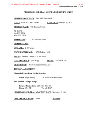
Planning Commission: April 23, 2024 NEIGHBORHOOD PLAN AMENDMENT REVIEW SHEET NEIGHORHOOD PLAN: East MLK Combined CASE#: NPA-2023-0015.05.SH DATE FILED: October 19, 2023 PROJECT NAME: 1702 Deloney Street PC DATE: April 23, 2024 March 26, 2024 ADDRESS/ES: 1702 Deloney Street DISTRICT AREA: 1 SITE AREA: 2.027 acres OWNER/APPLICANT: 1702 Deloney LLC AGENT: Drenner Group, PC (Leah Bojo) STAFF EMAIL: Tyler.Tripp@austintexas.gov TYPE OF AMENDMENT: Change in Future Land Use Designation CASE MANAGER: Tyler Tripp PHONE: (512) 974- 3362 From: Single Family To: Multifamily Residential Base District Zoning Change Related Zoning Case: C14-2023-0141.SH To: MF-2-NP From: SF-3-NP NEIGHBORHOOD PLAN ADOPTION DATE: November 2, 2002 CITY COUNCIL DATE: TBD ACTION: 1 of 2716 NPA-2023-0015.05.SH - 1702 Deloney Street; District 1 Planning Commission: April 23, 2024 PLANNING COMMISSION RECOMMENDATION: April 23, 2023 – (action pending) March 26, 2024 – Postponed to April 23, 2023 on the consent agenda at the request of the Applicant. (A. Azhar – 1st; F. Maxwell – 2nd] Vote: 10-0 [G. Anderson off the dais. P. Howard and A. Phillips absent]. STAFF RECOMMENDATION: To support the applicant’s request for Multifamily Residential land use. BASIS FOR STAFF’S RECOMMENDATION: Staff supports the applicant’s request for Multifamily Residential land use because there is Mixed Use land use directly to the north. Multifamily residential land use will serve as a buffer between the mixed-use land use to the north and the single family land use to the south. The property is also located less than 600 feet south of East MLK Junior Blvd, which is an activity corridor as identified on the imagined Austin Comprehensive Plan where additional density can be accommodated. The property owner is proposing approximately 45 mixed residential dwelling units, which will provide additional housing choices for the city and the planning area. 2 2 of 2716 NPA-2023-0015.05.SH - 1702 Deloney Street; District 1 Planning Commission: April 23, 2024 Below are sections of the East MLK Combined Neighborhood Plan that supports the applicant’s request: 3 LAND USE DESCRIPTIONS: EXISTING LAND USE: Single family - Single family detached or up to three residential uses at typical urban and/or suburban densities. Purpose 1. Preserve the land use pattern and future viability of existing neighborhoods; 2. Encourage new infill development that continues existing neighborhood patterns of development; and 3. Protect residential neighborhoods from incompatible business or industry and the loss of existing housing. Application 3 of 2716 NPA-2023-0015.05.SH - 1702 Deloney Street; District 1 Planning Commission: April 23, 2024 1. Existing single‐family areas should generally be designated as single family to preserve established neighborhoods; and 2. May include small lot options (Cottage, Urban Home, Small Lot Single Family) and two‐family residential options (Duplex, Secondary Apartment, Single Family Attached, Two‐Family Residential) in areas considered appropriate for this type of infill development. PROPOSED LAND USE: Multifamily Residential - Higher-density housing with 3 or more units on one lot. Purpose 1. Preserve existing multifamily and affordable housing; 2. Maintain and create affordable, safe, and well-managed rental housing; and 3. Make it possible for existing residents, both homeowners and renters, to continue to live in their neighborhoods. 4. Applied to existing or proposed mobile home parks. Application 1. Existing apartments should be designated as multifamily unless designated as mixed use; 2. Existing multifamily-zoned land should not be recommended for a less intense land use category, unless based on sound planning principles; and 3. Changing other land uses to multifamily should be encouraged on a case-by-case basis. Yes Yes Yes No Yes No No Yes Yes Imagine Austin Decision Guidelines Complete Community Measures Imagine Austin Growth Concept Map: Located within or adjacent to an Imagine Austin Activity Center, Imagine Austin Activity Corridor, or Imagine Austin Job Center as identified the Growth Concept Map. Name(s) of Activity Center/Activity Corridor/Job Center: • Approx. 0.10 miles south of E. MLK Jr. Blvd, an activity corridor Mobility and Public Transit: Located within 0.25 miles of public transit stop and/or light rail station. Mobility and Bike/Ped Access: Adjoins a public sidewalk, shared path, and/or bike lane. Connectivity, Good and Services, Employment: Provides or is located within 0.50 miles to goods and services, and/or employment center. • There are limited commercial uses along E. MLK Jr. Blvd. Connectivity and Food Access: Provides or is located within 0.50 miles of a grocery store/farmers market. Connectivity and Education: Located within 0.50 miles from a public school or university. • Approx. 1.7 miles from Norman-Sims Elementary School • Approx.. 1.9 miles from East Austin College Prep Connectivity and Healthy Living: Provides or is located within 0.50 miles from a recreation area, park or walking trail. 0.5 miles from Givens District Park Connectivity and Health: Provides or is located within 0.50 miles of health facility (ex: hospital, urgent care, doctor’s office, drugstore clinic, and/or specialized outpatient care.) • • Yes Housing Affordability: Provides a minimum of 10% of units for workforce housing (80% MFI or 0.6 miles from Austin Medical Clinic 4 4 of 2716 NPA-2023-0015.05.SH - 1702 Deloney Street; District 1 Planning Commission: April 23, 2024 less) and/or fee in lieu for affordable housing. • Yes Housing Choice: Expands the number of units and housing choice that suits a variety of household sizes, incomes, and lifestyle needs of a diverse population (ex: apartments, triplex, granny flat, live/work units, cottage homes, and townhomes) in support of Imagine Austin and the Strategic Housing Blueprint. Mixed use: Provides a mix of residential and non-industrial uses. Culture and Creative Economy: Provides or is located within 0.50 miles of a cultural resource (ex: library, theater, museum, cultural center). Culture and Historic Preservation: Preserves or enhances a historically and/or culturally significant site. Creative Economy: Expands Austin’s creative economy (ex: live music venue, art studio, film, digital, theater.) Workforce Development, the Economy and Education: Expands the economic base by creating permanent jobs, especially in industries that are currently not represented in particular area or that promotes a new technology, and/or promotes educational opportunities and workforce development training. Industrial Land: Preserves or enhances industrial land. Number of “Yes’s” Imagine Austin Priority Program PUD Specific Bonus Features Public Space Features and Public Art: Incorporates public space features and/or public art into project (Ex: plazas, streetscapes, gardens, and other people-friendly spaces where different ages can socially interact). Integrates and/or Expands Green Infrastructure: Preserves or expands Austin’s green infrastructure (ex: parkland, community gardens, green streets, creeks, stormwater features that mimic natural hydrology) into the urban environment and transportation network. Protects the Environment: Reduces greenhouse gas emissions, water, energy usage, and/or increases waste diversion. Protects Environmentally Sensitive Lands: Protects Austin’s natural resources and environmental systems by limiting land use and transportation development over or near environmentally sensitive areas, preserves open space, and protects natural resources more than ordinance requirements. Water/Wastewater Infrastructure: Sustainably manages Austin’s water resources and stream corridors through on-site use of storm water, effective landscaping, flood mitigation, and other low- impact development techniques more than ordinance requirements. Total Number of “Yes’s” PUD Development is not proposed No N0 No No n/a n/a n/a n/a n/a 5 5 of 2716 NPA-2023-0015.05.SH - 1702 Deloney Street; District 1 Proximity to Imagine Austin Activity Corridors and Centers Planning Commission: April 23, 2024 6 6 of 2716 NPA-2023-0015.05.SH - 1702 Deloney Street; District 1 Planning Commission: April 23, 2024 Proximity to Public Parks 7 7 of 2716 NPA-2023-0015.05.SH - 1702 Deloney Street; District 1 Planning Commission: April 23, 2024 Proximity to Public Transportation IMAGINE AUSTIN GROWTH CONCEPT MAP Definitions Neighborhood Centers - The smallest and least intense of the three mixed-use centers are neighborhood centers. As with the regional and town centers, neighborhood centers are walkable, bikable, and supported by transit. The greatest density of people and activities in neighborhood centers will likely be concentrated on several blocks or around one or two intersections. However, depending on localized conditions, different neighborhood centers can be very different places. If a neighborhood center is designated on an existing commercial area, such as a shopping center or mall, it could represent redevelopment or the addition of housing. A new neighborhood center may be focused on a dense, mixed-use core surrounded by a mix of housing. In other instances, new or redevelopment may occur incrementally and concentrate people and activities along several blocks or around one or two intersections. Neighborhood centers will be more locally focused than either a regional or a town center. Businesses and services—grocery and department stores, doctors and dentists, shops, branch libraries, dry cleaners, hair salons, schools, restaurants, and other small and local businesses—will generally serve the center and surrounding neighborhoods. 8 8 of 2716 NPA-2023-0015.05.SH - 1702 Deloney Street; District 1 Planning Commission: April 23, 2024 Town Centers - Although less intense than regional centers, town centers are also where many people will live and work. Town centers will have large and small employers, although fewer than in regional centers. These employers will have regional customer and employee bases, and provide goods and services for the center as well as the surrounding areas. The buildings found in a town center will range in size from one-to three-story houses, duplexes, townhouses, and rowhouses, to low-to midrise apartments, mixed use buildings, and office buildings. These centers will also be important hubs in the transit system. Regional Centers - Regional centers are the most urban places in the region. These centers are and will become the retail, cultural, recreational, and entertainment destinations for Central Texas. These are the places where the greatest density of people and jobs and the tallest buildings in the region will be located. Housing in regional centers will mostly consist of low to high-rise apartments, mixed use buildings, row houses, and townhouses. However, other housing types, such as single-family units, may be included depending on the location and character of the center. The densities, buildings heights, and overall character of a center will depend on its location. Activity Centers for Redevelopment in Sensitive Environmental Areas - Five centers are located over the recharge or contributing zones of the Barton Springs Zone of the Edwards Aquifer or within water-supply watersheds. These centers are located on already developed areas and, in some instances, provide opportunities to address long-standing water quality issues and provide walkable areas in and near existing neighborhoods. State-of-the-art development practices will be required of any redevelopment to improve stormwater retention and the water quality flowing into the aquifer or other drinking water sources. These centers should also be carefully evaluated to fit within their infrastructural and environmental context. Job Centers - Job centers accommodate those businesses not well-suited for residential or environmentally- sensitive areas. These centers take advantage of existing transportation infrastructure such as arterial roadways, freeways, or the Austin-Bergstrom International airport. Job centers will mostly contain office parks, manufacturing, warehouses, logistics, and other businesses with similar demands and operating characteristics. They should nevertheless become more pedestrian and bicycle friendly, in part by better accommodating services for the people who work in those centers. While many of these centers are currently best served by car, the growth Concept map offers transportation choices such as light rail and bus rapid transit to increase commuter options. Corridors - Activity corridors have a dual nature. They are the connections that link activity centers and other key destinations to one another and allow people to travel throughout the city and region by bicycle, transit, or automobile. Corridors are also characterized by a variety of activities and types of buildings located along the roadway — shopping, restaurants and cafés, parks, schools, single-family houses, apartments, public buildings, houses of worship, mixed-use buildings, and offices. Along many corridors, there will be both large and small redevelopment sites. These redevelopment opportunities may be continuous along stretches of the corridor. There may also be a series of small neighborhood centers, connected by the roadway. Other corridors may have fewer redevelopment 9 9 of 2716 NPA-2023-0015.05.SH - 1702 Deloney Street; District 1 Planning Commission: April 23, 2024 opportunities, but already have a mixture of uses, and could provide critical transportation connections. As a corridor evolves, sites that do not redevelop may transition from one use to another, such as a service station becoming a restaurant or a large retail space being divided into several storefronts. To improve mobility along an activity corridor, new and redevelopment should reduce per capita car use and increase walking, bicycling, and transit use. Intensity of land use should correspond to the availability of quality transit, public space, and walkable destinations. Site design should use building arrangement and open space to reduce walking distance to transit and destinations, achieve safety and comfort, and draw people outdoors. BACKGROUND: The plan amendment application was filed on October 19, 2023. The applicant proposes to change the future land use map from Single Family to Multifamily Residential land use. The applicant proposes to change the zoning rom SF-3-NP (Family Residence district – Neighborhood Plan) to MF-2-NP (Multifamily Residential Low Density district – Neighborhood Plan) for a S.M.A.R.T. Housing Certified mixed residential development. The applicant proposes 45 residential units with10% (5 units) at or below 80% MFI, with an affordability period of one year. PUBLIC MEETINGS: The ordinance-required community meeting was virtually held on August 17, 2023. The recorded meeting can be found here: https://publicinput.com/q6665. Approximately 226 community meeting notices were mailed to people who have utility accounts or own property within 500 feet of the property, in addition to neighborhood and environmental groups who requested notification for the area in the Community Registry. Two city staff members attended, Tyler Tripp and Mark Walters from the Planning Department, in addition to Leah Bojo and Drew Rafaelle from Drenner Group, PC, the applicant’s agents. Three people from the neighborhood attended. Here are highlights of Leah Bojo’s presentation: • The property is 2.027 acres in size and is mostly undeveloped, but there is one house on the property. 10 10 of 2716 NPA-2023-0015.05.SH - 1702 Deloney Street; District 1 Planning Commission: April 23, 2024 • The property has access on both Deloney Street and EM Franklin, but there is a creek that runs in the middle. It will be development as one project, but will have development on the frontage of EM Franklin and Delone. • It has great public transportation and is near proposed urban trails. • The existing zoning is SF-3-NP and the proposed zoning is MF-2-NP. • The owner proposes a mixed residential development (townhomes, single family detached apartments) for rent. • The project is S.M.A.R.T. Housing certified which will provide 10% at 80% MFI for five units for an affordability period of one year. Q: I live on EM Franklin Street, these streets are loaded with traffic and we have almost no sidewalks as it is. Will there be a traffic study? A: We are not required to do a traffic study, but there will be Neighborhood Traffic Study that will be submitted to the City’s Transportation Department. We will be required to do sidewalks on our portion of the property. There will be for one parking space per residential unit. Q: Is there a minimum acreage required for this change? A: The proposed zoning of MF-2 has a minimum lot size of 8,00 sq. ft and this lot is 2.027 acres. Q: Can the property not be developed in the current zoning? A: It can be developed as single-family homes under the SF-3-NP zoning, and potentially up to three units on each lot if they meet the development regulations, but they could not develop as multifamily. Q: Why should the neighborhood support this? A: This is a great location for more residential homes, not just for one house. Austin is in a housing crunch and the diversity of types of residential units will help meet Austin’s housing needs. The property is also near public transportation. Q: What development will happen along the creek? A: We will not be able to build in the flood plain. Q: Will this development help the CapMetro route #18 run more frequently? A: From what I understand, when ridership increases on a bus route, CapMetro could decide to increase the frequency of the route. 11 11 of 2716 NPA-2023-0015.05.SH - 1702 Deloney Street; District 1 Planning Commission: April 23, 2024 S.M.A.R.T. Housing Certification Letter 12 12 of 2716 NPA-2023-0015.05.SH - 1702 Deloney Street; District 1 Planning Commission: April 23, 2024 13 13 of 2716 NPA-2023-0015.05.SH - 1702 Deloney Street; District 1 Applicant Summary Letter from Application Planning Commission: April 23, 2024 14 14 of 2716 NPA-2023-0015.05.SH - 1702 Deloney Street; District 1 Planning Commission: April 23, 2024 Letter of Recommendation from the Neighborhood Plan Contact Team (NPCT) (No letter as of March 20, 2024) 15 15 of 2716 NPA-2023-0015.05.SH - 1702 Deloney Street; District 1 Planning Commission: April 23, 2024 16 16 of 2716 NPA-2023-0015.05.SH - 1702 Deloney Street; District 1 Planning Commission: April 23, 2024 17 17 of 2716 NPA-2023-0015.05.SH - 1702 Deloney Street; District 1 Planning Commission: April 23, 2024 18 18 of 2716 NPA-2023-0015.05.SH - 1702 Deloney Street; District 1 Planning Commission: April 23, 2024 19 19 of 2716 NPA-2023-0015.05.SH - 1702 Deloney Street; District 1 Planning Commission: April 23, 2024 20 20 of 2716 NPA-2023-0015.05.SH - 1702 Deloney Street; District 1 Planning Commission: April 23, 2024 21 21 of 2716 NPA-2023-0015.05.SH - 1702 Deloney Street; District 1 Planning Commission: April 23, 2024 22 22 of 2716 NPA-2023-0015.05.SH - 1702 Deloney Street; District 1 Planning Commission: April 23, 2024 23 23 of 2716 NPA-2023-0015.05.SH - 1702 Deloney Street; District 1 Planning Commission: April 23, 2024 24 24 of 2716 NPA-2023-0015.05.SH - 1702 Deloney Street; District 1 Planning Commission: April 23, 2024 25 25 of 2716 NPA-2023-0015.05.SH - 1702 Deloney Street; District 1 Planning Commission: April 23, 2024 26 26 of 2716 NPA-2023-0015.05.SH - 1702 Deloney Street; District 1 Planning Commission: April 23, 2024 Correspondence Received (No correspondence received) 27 27 of 2716 NPA-2023-0015.05.SH - 1702 Deloney Street; District 1