11 C14-2023-0056 - W. US Hwy 290; District 8.pdf — original pdf
Backup
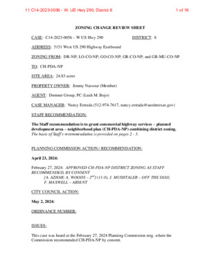
ZONING CHANGE REVIEW SHEET CASE: C14-2023-0056 – W US Hwy 290 DISTRICT: 8 ADDRESS: 5151 West US 290 Highway Eastbound ZONING FROM: DR-NP; LO-CO-NP; GO-CO-NP; GR-CO-NP; and GR-MU-CO-NP TO: CH-PDA-NP SITE AREA: 24.83 acres PROPERTY OWNER: Jimmy Nassour (Member) AGENT: Drenner Group, PC (Leah M. Bojo) CASE MANAGER: Nancy Estrada (512-974-7617, nancy.estrada@austintexas.gov) STAFF RECOMMENDATION: The Staff recommendation is to grant commercial highway services – planned development area – neighborhood plan (CH-PDA-NP) combining district zoning. The basis of Staff’s recommendation is provided on pages 2 - 3. PLANNING COMMISSION ACTION / RECOMMENDATION: April 23, 2024: February 27, 2024: APPROVED CH-PDA-NP DISTRICT ZONING AS STAFF RECOMMENDED, BY CONSENT [A. AZHAR; A. WOODS – 2nd] (11-0), J. MUSHTALER – OFF THE DIAS; F. MAXWELL – ABSENT CITY COUNCIL ACTION: May 2, 2024: ORDINANCE NUMBER: ISSUES: This case was heard at the February 27, 2024 Planning Commission mtg. where the Commission recommended CH-PDA-NP by consent. 1 of 1611 C14-2023-0056 - W. US Hwy 290; District 8 C14-2023-0056 Page 2 The Applicant had amended their rezoning request from (LI-PDA-NP) to (CH-PDA-NP) in order for the proposed development to include a combination of commercial and multifamily uses. The original zoning request did not require a change in the future land use map. However, when the rezoning request was amended, it triggered a neighborhood plan amendment. Therefore, both cases are being brought before the Planning Commission. On April 4, 2024, City of Austin staff sponsored a virtual community meeting to provide an opportunity for the neighborhood planning contact team, nearby residents, property owners, and any other interested parties to discuss the proposed development and the neighborhood plan amendment request. CASE MANAGER COMMENTS: The subject rezoning area is approximately 24.83 acres and is developed with a large specialty retail business and surface parking. Approximately half the acreage is undeveloped. The property is located at the intersection of the West US 290 Highway eastbound service road and Staggerbrush Road and is situated near the southwest corner of West US 290 Highway and South Mopac Expressway. Directly to the east of the site across Staggerbrush Road is a big box development (GR-CO-NP). To the west of the site is a storage facility and medical center (GR-MU-NP). Multifamily is located both west and south of the site (MF-2- NP; MF-3-CO-NP). This site is located within the Edwards Aquifer Recharge zone. A critical water quality zone and drainage easement area are south of this property across Staggerbrush Road (P-NP). (Please refer to Exhibits A (Zoning Map), A-1 (Aerial View). The 1998 Replat of Block A, Lots 1 & 2, Storm 290 recorded plat allows for a maximum of 60% impervious cover under Ordinance No. 911010-D which states that the tracts must comply with the Comprehensive Watershed Ordinance No. 860508-V. However, the applicant has been in communication with Watershed Protection staff and has agreed to reduce the impervious cover by 3.5 % to 56.5% which equates to approximately half an acre of impervious cover. The reduction of impervious cover will be included as part of the staff recommendation within the PDA. The applicant is requesting commercial highway services – planned development area – neighborhood plan (CH-PDA-NP) for a proposed mixed use development that will include both commercial and multifamily uses. The project will include 1000 residential units and 150,000 square feet of commercial/retail uses. The multifamily residential units are being proposed for the undeveloped southern portion of the site. Access to the development will be from West US 290 Highway and Staggerbrush Road. As set forth in Land Development Code Section 25-2-441, the regulations of a planned development area (PDA) may modify: 1) permitted or conditional uses authorized by the base zoning district, 2) site development regulations except for compatibility standards, and 2 of 1611 C14-2023-0056 - W. US Hwy 290; District 8 C14-2023-0056 Page 3 3) off-street parking or loading regulations, sign regulations or screening regulations applicable in the base district. The Applicant’s proposed PDA consists of the following elements: 1) Prohibits the following commercial and industrial uses: Agricultural Sales and Services Automotive Rentals Automotive Repair Services Automotive Sales Automotive Washing (of any type) Bail Bond Services Building Maintenance Services Campground Construction Sales and Services Drop-Off Recycling Collection Facility Veterinary Services Electronic Prototype Assembly Electronic Testing Equipment Repair Services Equipment Sales Exterminating Services Funeral Services Kennels Pawn Shop Services Pedicab Storage and Dispatch Service Station Vehicle Storage Limited Warehousing and Distribution Maintenance and Service Facilities 2) Establishes that CH site development standards apply to the property, with the following modifications: a) A maximum impervious cover of 56.5% b) A maximum height of 120’ [LDC 25-2-582 (B)(5)] c) A 0-foot front yard setback, a 0-foot street side yard setback, a 0-foot interior side yard setback and a 0-foot rear yard setback NOTE: All other land use classification in the CH zoning district are permitted and conditional uses except as identified above. BASIS OF RECOMMENDATION: 1. The proposed zoning should be consistent with the purpose statement of the district sought. The proposed commercial highway services (CH) district is intended predominately for major mixed use developments of a service nature which typically have operating and traffic generation characteristics requiring location at the intersection of state maintained highways, excluding scenic arterials. Site development regulations and performance standards are intended to ensure adequate access to and from all uses, and to permit combinations of office, retail, commercial, and residential uses within a single development. The planned development area (PDA) combining district designation provides for industrial and commercial uses in certain commercial and industrial base districts. The neighborhood plan (NP) district denotes a tract located within the boundaries of an adopted Neighborhood Plan. 3 of 1611 C14-2023-0056 - W. US Hwy 290; District 8 C14-2023-0056 Page 4 2. Zoning should promote the policy of locating retail and more intensive zoning near the intersections of arterial roadways or at the intersections of arterials and major collectors. Commercial highway services (CH) zoning is appropriate for the proposed redevelopment due to its location near the intersection of West US 290 Highway and South Mopac Expressway. There is also a Capital Metro bus stop within the vicinity. EXISTING ZONING AND LAND USES: LAND USES Specialty Retail business; Surface parking; Undeveloped Site ZONING DR-NP; LO-CO-NP; GO-CO-NP; GR-CO- NP; GR-MU-CO-NP North N/A South P-NP; LO-CO-NP; DR-NP; RR-NP; MF-2-NP; GR-CO-NP GR-CO-NP GR-MU-NP; MF-2- NP; MF-3-CO-NP East West West US 290 Highway Multifamily; Archstone Greenbelt; Religious Assembly; Commercial Services Big box development Storage facilities; Medical Center; Commercial services; Multifamily Small Middle School SCENIC ROADWAY: No NEIGHBORHOOD PLANNING AREA: Oakhill Combined (East Oak Hill) WATERSHED: Williamson Creek and Barton Creek – Barton Springs Zone Watersheds – Drinking Water Protection Zone CAPITOL VIEW CORRIDOR: No SCHOOLS: Austin Independent School District Patton Elementary School COMMUNITY REGISTRY LIST: Austin Independent School District, Austin Lost and Found Pets, Covered Bridge Property Owners Association, Inc., East Oak Hill Neighborhood Association, Friends of Austin Neighborhoods, Neighborhood Empowerment Foundation, Oak Hill Association of Neighborhoods (OHAN), Oak Hill Neighborhood Plan - COA Liaison, Oak Hill Neighborhood Plan Contact Team, Oak Hill Trails Association, SELTexas, Save Barton Creek Assn., Save Our Springs Alliance, Sierra Club, Austin Regional Group, TNR BCP - Travis County Natural Resources Austin High School 4 of 1611 C14-2023-0056 - W. US Hwy 290; District 8 GR-MU-CO-NP* to GR-MU-CO-NP, to change a condition of zoning (*GR-MU-CO originally approved by City Council 5/3/2007 for cases C14-06-0181, C14- 06-0197, C14-06- 0199) SF-3-NP to SF-5- CO-NP, conditional overlay limiting development to 9 units C14-2023-0056 Page 5 AREA CASE HISTORIES: NUMBER C14-2008-0125 (West) & C14-2008- 0129 (East) – Oak Hill Combined Neighborhood Plan C14-2014-0011A & C14-2014-0011B – Garza Ranch REQUEST Oak Hill Combined NP & Rezonings COMMISSION Various hearings due to uncontested and contested tracts CITY COUNCIL Final NP approval 3/26/2009 Sent to CC with no recommendation from Planning Commission (12/9/2014) Apvd GR-MU-CO-NP with conditions (3/5/2015) C14-2013-0018 – Beiter 2 To Grant (5/14/13) SF-5- CO-NP, with conditions Apvd SF-5-CO-NP with conditions as Commission approved (6/6/2013) RELATED CASES: NPA-2024-0025.02 – This is the associated neighborhood plan amendment case from Mixed Use to a High Density Mixed Use designation that is being considered with this rezoning request. SPC-2024-0025.CC – The Garden Ridge Office Expansion site plan is currently in review. ADDITIONAL STAFF COMMENTS: Drainage The developer is required to submit a pre- and post-development drainage analysis at the subdivision and site plan stage of the development process. The City’s Land Development Code and Drainage Criteria Manual require that the Applicant demonstrate through engineering analysis that the proposed development will have no identifiable adverse impact on surrounding properties. 5 of 1611 C14-2023-0056 - W. US Hwy 290; District 8 C14-2023-0056 Page 6 Environmental This site is located over the Edwards Aquifer Recharge Zone. The site is in the Barton Creek and Williamson Creek Watersheds of the Colorado River Basin, which are classified as Barton Springs Zone Watersheds by Chapter 25-8 of the City’s Land Development Code. It is in the Drinking Water Protection Zone. Project applications at the time of this report are subject to the SOS Ordinance that allows 15% impervious cover in the recharge zone. According to floodplain maps there is no floodplain within or adjacent to the project location. Standard landscaping and tree protection will be required in accordance with LDC Chapters 25-2 and 25-8 for all development and/or redevelopment. At this time, site specific information is unavailable regarding vegetation, areas of steep slope, or other environmental features such as bluffs, springs, canyon rimrock, caves, sinkholes, and wetlands. Under current watershed regulations, development or redevelopment requires water quality control with increased capture volume and control of the 2-year storm on site. Runoff from the site is required to comply with pollutant load restrictions as specified in Land Development Code. At this time, no information has been provided as to whether this property has any preexisting approvals that preempt current water quality or Code requirements. PARD – Planning & Design Review Parkland dedication will be required at the time of subdivision or site plan application for new residential units proposed by this rezoning, mixed use-multifamily with LI-PDA, per City Code § 25-1-601, as amended. The intensity of the proposed development creates a need for over six acres of additional parkland, per requirements described in § 25-1-602; when the requirement is over six acres, parkland must be dedicated – see § 25-1-605 (A)(2)(a). As such, land dedication shall be required, unless the land available for dedication does not comply with the standards for dedication. Any remaining fees in-lieu after dedication shall also be required. If the land available for dedication complies with the parks standards, the Parks and Recreation Department (PARD) would consider the expansion and development of the adjacent Archstone Pocket Park to satisfy the requirement at time of permitting (whether subdivision or site plan). The dedication would satisfy the need for additional parkland in the Oak Hill area, a specific recommendation in the Parks and Recreation Department’s Long Range Plan. 6 of 1611 C14-2023-0056 - W. US Hwy 290; District 8 C14-2023-0056 Page 7 Should there be any remaining fees in-lieu, those fees shall be used toward park investments in the form of land acquisition and/or park amenities within the surrounding area, per the Parkland Dedication Operating Procedures § 14.3.11 and City Code § 25-1-607 (B)(1) & (2). If the applicant wishes to discuss parkland dedication requirements in advance of site plan or subdivision applications, please contact this reviewer: thomas.rowlinson@austintexas.gov. At the applicant’s request, PARD can provide an early determination letter of the requirements. Site Plan Site plans will be required for any new development other than single-family, two-family, or duplex residential. Any development which occurs in an SF-6 or less restrictive zoning district which is located 540-feet or less from property in an SF-5 or more restrictive zoning district will be subject to compatibility development regulations. The site is subject to compatibility standards due to the proximity of the DR-NP districts to the south. The property is located in the Barton Springs Zone overlay. This site is located within 150 feet of a wildland area, in the Wildland Urban Interface (WUI). Please see this website for more information about construction in the WUI: http://www.austintexas.gov/department/wildland-urban-interface-code Austin Transportation Department – Engineering Review A Traffic Impact Analysis shall be required at the time of site plan if triggered when land uses and intensities will be known per LDC 25-6-113. There is a proposed Urban Trail adjacent to this site, along the northern property line (Barton Corridor). The easement required is a minimum of 20 feet as this allows for a 12-foot trail (minimum trail width per the urban trails plan) and room for maintenance activity. This is the same for Tier I and Tier II trails. The adjacent street characteristics table is provided below: Name ASMP Classification ASMP Required ROW Existing ROW Existing Pavement Sidewalks Bicycle Route Capital Metro (within ¼ mile) Level 1 58’ 70’ 45’ Yes Yes Yes Staggerbrush Road W US 290 HWY SVRD EB Level 4 45’ Yes Yes Yes Coordinate with TxDOT Coordinate with TxDOT 7 of 1611 C14-2023-0056 - W. US Hwy 290; District 8 C14-2023-0056 Page 8 Austin Water Utility The landowner intends to serve the site with City of Austin water and wastewater utilities. The landowner, at own expense, will be responsible for providing any water and wastewater utility improvements, offsite main extensions, utility relocations and or abandonments required by the land use. The water and wastewater utility plan must be reviewed and approved by Austin Water for compliance with City criteria and suitability for operation and maintenance. Depending on the development plans submitted, water and or wastewater service extension requests may be required. All new development within the proposed project will be subject to City Code Chapter 25-9 and any future amendments relating to reclaimed water connections, water benchmarking, and mandatory onsite water reuse. All water and wastewater construction must be inspected by the City of Austin. The landowner must pay the City inspection fee with the utility construction. The landowner must pay the tap and impact fee once the landowner makes an application for a City of Austin water and wastewater utility tap permit. INDEX OF EXHIBITS AND ATTACHMENTS TO FOLLOW: Exhibit A: Zoning Map Exhibit A-1: Aerial Map Applicant’s Amended Summary Letter Applicant’s Original Summary Letter Correspondence 8 of 1611 C14-2023-0056 - W. US Hwy 290; District 8 TIRE SALES POOL/SPA SALES 92-0065 W US 290 HWY WB W US 290 HWY EB W 290 EB TO ROADRUNNER RAMP VACANT DRIVING RANGE R&D-CO-NP C14-99-0116 SPC95-0473C IP-CO-NP R86-097(DE) GR-NP R86-097(DE) GO-NP R8 6-0 9 7 CS-CO-NP WHSE 92-0065 CS-NP SP96-0452C LR-NP SP92-293C 92-0065 WHSE. STORAGE 88-007R C B O S T O N L N E FIC F E\O ( C N A R U S RR-NP N TIO A L L A T S S\IN A L G 86-07RC AUTO REPAIR WINDOW\COVERINGS CS-CO-NP SP-00-2280C R/\IN O LT A E R 88-07C SP92-293C 00-2155 CS-1-CO-NP SP96-0452C CS-CO-NP MASONRY\SUPPLIES R86-88RC SP-92-0253B CS-NP CONVENIENCE\STORAGE TELEPHONE CO RENTAL\EQUIP LR-NP BANK CS-NP VET. CLINIC 89-0005 OFFICE RR-NP 85-364RC 89-05 GR-CO-NP SP-92-0216C UNDEV 89-05 85-364RC W US 290 HWY SVRD WB W 290 WB TO BOSTON RAMP S M OPA C S B T O W U S 2 90 WB R A MP ! ! W US 290 HWY SVRD EB ! ! ! ! ! ! ! ! ! ! ! ! ! ! ! ! ROADRUNNER TO 290 EB RAMP W 290 EB TO MOPAC NB RAMP SP-94-0334C GR-MU-NP GR-CO-NP C14-95-0104 GR-MU-CO-NP CONV. ! STORAGE ! ! ! ! ! E G N A G R RIVIN F/D L O G N R L E N N U R D A O R CS-CO-MU-NP 95-0104 MF-3-CO-NP NPA-2016-0025.02 SP-98-0142C C14-2008-0129 95-0104 ( BARN/STABLE GO-CO-NP SP-99-2184CS SP-94-0115C ! 86-305 DR-NP 92-0120 95-0017 GR-CO-NP C14-95-0017 ! ! ! ! ! ! ! ! ! ! D R H S U R B R E G G A T S ! ! ! ! ! ! ! ! ! ! ! ! ! ! ! ! ! ! ! ! ! ! ! ! !! P-NP ! ! ! ! SP-95-0505C P M A B R C S A P O O S M B T W 0 9 W 2 MF-3-CO-NP MF-2-NP 86-305 86 -3 0 2 86-305 MF-2-NP APARTMENTS MF-2-CO-NP SP-94-0319C M O N T E R E Y O W/LO-NP C14-00-2212 MF-2-CO-NP A K S B LV D ± SUBJECT TRACT ! ! ! ! ! ! PENDING CASE ZONING BOUNDARY LO-CO-NP 86-305 86-305 ! ! P-NP ! ! ! ! ! ! ! ! ! ! ! ! ! DR-NP LO-CO-NP 86-305 RR-NP 86-302 86-302 GR-CO-NP SP- 98 -0 1 67 C ( ( SP-98-0151C ZONING ZONING CASE#: C14-2023-0056 RR-CO-NP B D S R V Y S P X C E A P O S M B Y S P X C E A P O S M B Y N P X C E A P O S M B D N R V Y S P X C E A P O S M C14-95-0117 GR-NP PUD-NP C814-05-0213 RR-NP MF-3-NP MF-3-CO-NP 86-302 This product is for informational purposes and may not have been prepared for or be suitable for legal, engineering, or surveying purposes. It does not represent an on-the-ground survey and represents only the approximate relative location of property boundaries. 1 " = 400 ' This product has been produced by the Housing and Planning Department for the sole purpose of geographic reference. No warranty is made by the City of Austin regarding specific accuracy or Created: 4/25/2023 9 of 1611 C14-2023-0056 - W. US Hwy 290; District 8 !!!!!!!!!!!!!!!!!!!!!!!!!!!!!!!!!!!!!!!!!!!!!!!!!!!!!!!!!!!!!!!!!!!!!!!!!!!!!!!!!(!(!(!(E19D19E20D20C14-2023-0056C14-2008-0129NPA-2016-0025.02C14-95-0017C14-95-0104C14-95-0117C14-99-0116C814-05-0213C14-00-2212W US 290 HWY EBW US 290 HWY WBW US 290 HWY SVRD EBW US 290 HWY SVRD WBSTAGGERBRUSH RDS MOPAC EXPY SBS MOPAC EXPY SVRD SBS MOPAC EXPY NBBOSTON LNW 290 EB TO MOPAC NB RAMPROADRUNNER LNS MOPAC SB TO W US 290 WB RAMPS MOPAC EXPY SVRD NBROADRUNNER TO 290 EB RAMPW 290 WB TO S MOPAC SB RAMPW 290 WB TO BOSTON RAMPMONTEREY OAKS BLVDW 290 EB TO ROADRUNNER RAMPGR-CO-NPRR-NPGR-CO-NPCS-NPGR-MU-NPGR-CO-NPRR-NPMF-2-CO-NPDR-NPCS-NPP-NPGO-NPMF-2-NPMF-2-NPGO-CO-NPGR-CO-NPGR-MU-CO-NPMF-3-CO-NPCS-CO-NPCS-CO-NPIP-CO-NPMF-3-CO-NPRR-NPLO-CO-NPGR-NPDR-NPRR-NPLR-NPLO-CO-NPP-NPCS-NPR&D-CO-NPRR-CO-NPMF-3-CO-NPMF-2-CO-NPLR-NPCS-CO-MU-NPCS-CO-NPW/LO-NPPUD-NPGR-NPMF-3-NPCS-1-CO-NPW US Hwy 290±This product has been produced by the Planning Department for the sole purpose of geographic reference. No warrantyis made by the City of Austin regarding specific accuracy or completeness.ZONING CASE#:LOCATION:SUBJECT AREA:GRID:MANAGER:C14-2023-00565151 W US Hwy 290 EB24.83 AcresE19Nancy EstradaCreated: 5/31/2023SUBJECT TRACTZONING BOUNDARY!!!!!!PENDING CASECREEK BUFFER0200400600800100Feet10 of 1611 C14-2023-0056 - W. US Hwy 290; District 8 April 3, 2023 Updated 12/4/2023 Via Electronic Delivery Leah M. Bojo direct dial: (512) 807-2918 lbojo@drennergroup.com Ms. Lauren Middleton-Pratt Planning Department City of Austin 1000 E 11th Street, Suite 200 Austin, TX 78702 Dear Ms. Middleton-Pratt: Re: 5151 W US Highway 290 – Zoning application for the 24.83-acre piece of property located at 5151 W US Highway 290 in the City of Austin, Travis County, Texas (the “Property”). As representatives of the Owners of the Property, we respectfully submit the enclosed zoning application for 5151 W US Highway 290. The project is located in the full purpose jurisdiction of the City of Austin and consists of 24.83 acres located on the east side of U.S. Highway 290 at the northeast corner of U.S. Highway 290 and Staggerbrush Road. The Property has multiple zones GR-CO-NP (Community Commercial–Conditional Overlay – Neighborhood Plan) GR-MU-CO-NP (Community Commercial–Mixed Use-Conditional Overlay – Neighborhood Plan) , GO-CO-NP (General Office-Conditional Overlay-Neighborhood Plan), LO-CO-NP (Limited Office-Conditional Overlay-Neighborhood Plan), DR-NP (Development Reserve-Neighborhood Plan) to CH-PDA-NP, Commercial Highway – Planned Development Area – Neighborhood Plan. The purpose of this rezoning is to allow for a mixed-use development including commercial and multifamily uses. The Property is located within the Oak Hill Combined Planning Area – East Oak Hill and has a Future Land Use Map (FLUM) designation of Mixed-Use. In conjunction with the rezoning request a Traffic Impact Analysis (“TIA”) will be performed by the City. Please let me know if you or your team members require additional information or have any questions. Thank you for your time and attention to this project. Sincerely, Leah M. Bojo Drenner Group cc: Joi Harden, Planning and Zoning Department (via electronic delivery) 200 Lee Barton Drive, Suite 100 | Austin, Texas 78704 | 512-807-2900 | www.drennergroup.com 11 of 1611 C14-2023-0056 - W. US Hwy 290; District 8 April 3, 2023 Via Electronic Delivery Leah M. Bojo direct dial: (512) 807-2918 lbojo@drennergroup.com Ms. Rosie Truelove Housing Planning Department City of Austin 6310 Wilhelmina Delco Dr. Austin, TX 78752 Dear Ms. Truelove: Re: 5151 W US Highway 290 – Zoning application for the 24.83-acre piece of property located at 5151 W US Highway 290 in the City of Austin, Travis County, Texas (the “Property”). As representatives of the Owners of the Property, we respectfully submit the enclosed zoning application for 5151 W US Highway 290. The project is located in the full purpose jurisdiction of the City of Austin and consists of 24.83 acres located on the east side of U.S. Highway 290 at the northeast corner of U.S. Highway 290 and Staggerbrush Road. The Property has multiple zones GR-CO-NP (Community Commercial–Conditional Overlay – Neighborhood Plan) GR-MU-CO-NP (Community Commercial–Mixed Use-Conditional Overlay – Neighborhood Plan) , GO-CO-NP (General Office-Conditional Overlay-Neighborhood Plan), LO-CO-NP (Limited Office-Conditional Overlay-Neighborhood Plan), DR-NP (Development Reserve-Neighborhood Plan) to LI-PDA, Limited Industrial Services – Planned Development Area. The purpose of this rezoning is to allow for a mixed-use development including commercial and multifamily uses. The Property is located within the Oak Hill Combined Planning Area – East Oak Hill and has a Future Land Use Map (FLUM) designation of Mixed-Use. In conjunction with the rezoning request a Traffic Impact Analysis (“TIA”) will be performed by the City. Please let me know if you or your team members require additional information or have any questions. Thank you for your time and attention to this project. Sincerely, Leah M. Bojo Drenner Group cc: Joi Harden, Planning and Zoning Department (via electronic delivery) 200 Lee Barton Drive, Suite 100 | Austin, Texas 78704 | 512-807-2900 | www.drennergroup.com 12 of 1611 C14-2023-0056 - W. US Hwy 290; District 8 From: LEIGH ZIEGLER Sent: Wednesday, April 17, 2024 2:04 PM To: Meredith, Maureen <Maureen.Meredith@austintexas.gov>; Estrada, Nancy <Nancy.Estrada@austintexas.gov> Subject: NPA-2024-0025.02 and C14-2023-0056_5151 W US 290 Hwy External Email - Exercise Caution April 17, 2024 Maureen Meredith, Please provide answers to stakeholder requests for information regarding 5151 W US 290 HWY: Text of the existing Conditional Overlay details Details regarding the proposed height, bulk and location of such building and line of sight analyses from adjoining properties and/or rights of way. Schematic drawings which illustrate the height, bulk and location of such buildings and line-of-sight analyses from adjoining properties and/or rights of way. Schematics and acreage square footage of open space or buffer areas The phasing of the development and the manner in which each phase can exist as a stable independent unit consistent with the provision of adequate public facilities and services. Right of way widths, wastewater disposal, stormwater analysis. Details regarding the addition of fire-fighting infrastructure, staff, and equipment, including additional ladder trucks, adequate water pressure and quantity to serve the added height and density proposed Firewise construction requirements for the proposed project. Evacuation plans in the event of a fire or other natural or manmade disaster affecting the proposed 1000 units and surrounding inhabitants. The expected population impact upon school overcrowding in the area The Oak Hill NPCT concludes that the current land use (MU) seems most appropriate and allows for housing growth consistent with recent Council density allowances. Over more, it is obvious that much is missing from this project request. The project claims 1000 housing units 13 of 1611 C14-2023-0056 - W. US Hwy 290; District 8 but requires a 3:1 FAR and is not considering affordable housing. It is evident another use could occupy over half of the project-perhaps the reason for the non-conforming LI zoning request. In the case of this 24.83 acres property at 5151 Highway 290 strategically located for opportunities in development, the Oak Hill Neighborhood Planning Contact Team cannot support the requested height/density, nor the non-conforming zoning request. Most importantly, we would like to be certain that any development in this area while perhaps more intense than surrounding areas will not jeopardize the safety of residents. The area of request is predominantly 2-4 stories in height and is nestled near the convergence of Barton Creek, Williamson Creek and Sunset Valley. We ask the developer to define the need for 120 ft in height when 70 ft (the height we are told maximum development cost/profit below q20 ft) would produce the highest building along our major traffic arteries. This area is not downtown and there have been no significant improvements in infrastructure. Please do not move forward with this land use change until greater focus is given to the project. Thank you in advance for addressing the concerns of our neighbors and attach this initial request for information to the case file. Leigh Ziegler OHNPCT, Chair CAUTION: This is an EXTERNAL email. Please use caution when clicking links or opening attachments. If you believe this to be a malicious or phishing email, please report it using the "Report Message" button in Outlook. For any additional questions or concerns, contact CSIRT "cybersecurity@austintexas.gov." 14 of 1611 C14-2023-0056 - W. US Hwy 290; District 8 From: Signe Porteshawver Sent: Thursday, April 4, 2024 5:08 PM To: Leah Bojo Cc: Meredith, Maureen <Maureen.Meredith@austintexas.gov>; Estrada, Nancy <Nancy.Estrada@austintexas.gov>; Temaria Davis Subject: Re: NPA-2024-0025.02 External Email - Exercise Caution Thanks all, I wrote because that lot is currently wild space, lined by old oaks, a small patch of forest, and filled in with meadow. This is already home to a consortium of wild creatures and it breaks my heart that all might get raised to build yet another dwelling for humans, even though Austin is already over-built. I understand this is private land and not up to me, but I remain faithful to the wild ones by advocating for them anyway. I hope your plans will include leaving the trees standing. I will grieve for this place. Signe On Mon, Apr 1, 2024 at 3:52 PM Leah Bojo wrote: Thank you, Maureen, and hello Signe, Yes, we are requesting this change in order to build multifamily instead of office. Not a complex, but more likely a MF building. Please let me know if you have any other questions I can answer. Thank you! Leah M. Bojo, AICP, Director of Land Use & Entitlements 2705 Bee Caves Road, Suite 100, Austin, TX 78746 Drenner Group, PC From: Signe Porteshawver Sent: Saturday, March 30, 2024 3:33 PM To: Meredith, Maureen <Maureen.Meredith@austintexas.gov> Subject: NPA-2024-0025.02 External Email - Exercise Caution Hi Maureen, I just got a notice about the rezoning case for Oak Hill Combined Neighborhood Plan. Is the zoning change to allow the building of an apartment complex? Thank you, Signe 15 of 1611 C14-2023-0056 - W. US Hwy 290; District 8 From: Bobby Levinski Sent: Monday, February 26, 2024 12:57 PM To: Maxwell, Felicity - BC; Haynes, Adam - BC; Cox, Grayson - BC; Anderson, Greg - BC; Mushtaler, Jennifer - BC; Cohen, Jessica - BC; Howard, Patrick - BC; Hempel, Claire - BC; Woods, Alice - BC; Skidmore, Danielle - BC; Johnson, Ryan - BC; Azhar, Awais - BC; Phillips, Alberta - BC; Ramirez, Nadia - BC; Hunter, Candace - BC Cc: Estrada, Nancy; Harden, Joi; Rivera, Andrew; lbojo Subject: Comments for Public Hearings - Items 22 External Email - Exercise Caution Item 22. Oppose LI-PDA. Using LI-PDA zoning to bypass zoning regulations is inappropriate, inconsistent with state law, city code,and the comprehensive plan. A lawsuit was filed by the Save Our Springs Alliance on Friday raising concern about this "loophole" in the zoning code on a different site affecting the Colorado River. This is within the Barton Springs Zone and raises similar concerns. I understand the politics behind these requests, but it's just going to keep us in the courthouse and not moving forward as a community. This is a disturbing trend that must stop. -- Bobby Levinski Attorney, Save Our Springs Alliance 4701 Westgate Blvd, Ste. D-401 Austin, Texas 78745 512-477-2320 (Ext. 105) www.sosalliance.org *Please consider making a donation to support the education, advocacy, and action necessary to save our springs, creeks, and open spaces. SOS is 501(c)(3) nonprofit organization.* 16 of 1611 C14-2023-0056 - W. US Hwy 290; District 8