11 C14-2023-0149 - Donely NBG Rezoning; District 4 Part 1.pdf — original pdf
Backup
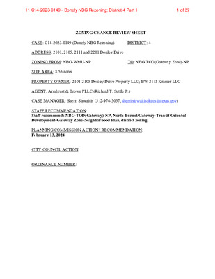
ZONING CHANGE REVIEW SHEET CASE: C14-2023-0149 (Donely NBG Rezoning) DISTRICT: 4 ADDRESS: 2101, 2105, 2111 and 2201 Donley Drive ZONING FROM: NBG-WMU-NP TO: NBG-TOD(Gateway Zone)-NP SITE AREA: 8.55 acres PROPERTY OWNER: 2101-2105 Donley Drive Property LLC; BW 2115 Kramer LLC AGENT: Armbrust & Brown PLLC (Richard T. Suttle Jr.) CASE MANAGER: Sherri Sirwaitis (512-974-3057, sherri.sirwaitis@austintexas.gov) STAFF RECOMMENDATION: Staff recommends NBG-TOD(Gateway)-NP, North Burnet/Gateway-Transit Oriented Development-Gateway Zone-Neighborhood Plan, district zoning. PLANNING COMMISSION ACTION / RECOMMENDATION: February 13, 2024 CITY COUNCIL ACTION: ORDINANCE NUMBER: 1 of 2711 C14-2023-0149 - Donely NBG Rezoning; District 4 Part 1 C14-2023-0149 2 ISSUES: N/A CASE MANAGER COMMENTS: The property in question consists of four lots making up 8.55 acres that are currently developed with an office/warehouse structure (Metric Center), a surface parking area and a three-story office building (Innovation Park). The property is within the North Burnet Gateway Neighborhood Planning area and is zoned NBG-WMU-NP, North Burnet Gateway- Warehouse Mixed Use-Neighborhood Plan Combining District. The site located on Donely Drive, a level 2/collector roadway, to the east of Missouri Pacific Railroad. There is also NBG-WMU-NP zoning to the east and west that is developed with a communication services facility (CBS Austin) and office/warehouse uses respectively. To the north, across Donely Drive, there are lots that are zoned NBG-TOD-NP and NBG-NMU-NP and are developed with one-story offices. To the south, there are one-story industrial warehouses (Denton Center) that are zoned NBG-CI-NP. The applicant is requesting to rezone the property from NBG-NP (WMU Subdistrict) to NBG-NP (TOD-Gateway Zone Subdistrict) to allow for the construction of approximately 450 multi-family units (please see Applicant’s Request Letter-Exhibit C). The TOD subdistrict allows a FAR of 12:1 and a maximum building height of up to 491 feet, with development bonuses (please see the revised North Burnet Gateway - TOD subdistrict General Site Development Standards-Exhibit D). With the development of the Q2 stadium on the former McKalla tract to the west, there has been a transition in the zoning of the properties in this area within the North Burnet Gateway Neighborhood Plan (please see the Area Case Histories table below). Gateway zones are connected to the designated Transit Corridors and allow for greater height and density in close proximity to rail stations, such as the new McKalla Rail Station, which is slated to open later this month on February 24, 2024 to coincide with the kick-off of the fourth season for Austin FC. Therefore, the staff is recommending North Burnet Gateway-Neighborhood Plan (TOD- Gateway Zone Subdistrict) zoning for this property because the proposed zoning will be compatible with the continued redevelopment patterns in this area around Q2 stadium. The NBG-NP (TOD Gateway) subdistrict zoning is appropriate at this location because it is consistent with the NBG-TOD-NP zoning to the north. This property will be within walking distance of the proposed Red-Line Trail to the east that will provide pedestrian and bike paths that will connect to the new regional rail station. McKalla Station will feature daily operations including special game day trips as well as a double track design, two passenger platforms and expanded walking and bike paths connecting to the stadium and surrounding neighborhood. Therefore, the staff’s recommendation will permit uses and site development standards to the northeast of Q2 Stadium on Donely Drive that will allow for redevelopment to permit new commercial and residential uses. The City Council passed a resolution last May (please see Resolution No. 20230504-020 - Exhibit F). This resolution is a direction to the staff that the City Council wants community 2 of 2711 C14-2023-0149 - Donely NBG Rezoning; District 4 Part 1 C14-2023-0149 3 benefits for the additional entitlements (i.e.- height and FAR) in the Gateway zones. The proposed modifications to the development bonus provisions and fees for the North Burnet/Gateway Regulating Plan will allow maximum height and FAR to be achieved administratively with sufficient community benefit, and the maximums exceeded with council approval, similar to the Downtown Density Bonus Program, achieving greater community benefits such as housing and transit- and mobility-related improvements. The Urban Design division is currently working on creating these Tier 2 conditions for the North Burnet/Gateway Regulating Plan and these changes/amendments to the NBG will be presented to the City Council this spring in March of 2024. The applicant agrees with the staff’s recommendation. BASIS OF RECOMMENDATION: 1. The proposed zoning should be consistent with the purpose statement of the district sought. North Burnet/Gateway district is the designation for an identified area of existing low density, auto oriented commercial, warehouse, and industrial uses that is the subject of an approved master plan for redevelopment of the area into a higher density urban mixed use neighborhood that is more pedestrian friendly and takes advantage of the links to commuter rail transit and the area’s key position in the urban core. Transit-Oriented Development (TOD) is the highest density subdistrict in the North Burnet/Gateway area with the greatest focus on providing active pedestrian oriented uses at the ground level of buildings. Density is enabled to the highest degree in the “TOD- Gateway area” closest to the rail station and to a lesser degree elsewhere. Within the TOD Subdistrict certain areas are identified as active edges on the NBG Subdistrict Map. An active edge designation imposes additional specific land use and design requirements for development at visible intersections and along key streets that lead to the rail station. Neighborhood Plan district denotes a tract located within the boundaries of an adopted Neighborhood Plan. 2. The proposed zoning should promote consistency and orderly planning. The staff recommends the NBG-NP (TOD Gateway Zone) district because it is consistent with the NBG-NP (TOD) subdistrict zoning to the north across Donely Drive. The subject property is located within the boundaries of a “Regional Center” as designated on the Growth Concept Map in the Imagine Austin Comprehensive Plan. 3 of 2711 C14-2023-0149 - Donely NBG Rezoning; District 4 Part 1 C14-2023-0149 4 3. The proposed zoning should allow for a reasonable use of the property. The NBG-TOD(Gateway Zone)-NP zoning district would allow for a fair and reasonable use of the site. The proposed TOD(Gateway Zone) subdistrict will allow for high-density residential and commercial uses, which will provide desirable housing opportunities and additional services for the people that work in the surrounding office, commercial and industrial areas. This site is located near major employment, commercial and residential developments such as The Domain, J.J. Pickle Research Campus, IBM-Broadmoor Campus, Charles Schwab complex, etc. and a large outdoor entertainment use (Q2 Stadium). It is within the vicinity of the new McKalla Station adjacent to Q2 Stadium, near Delta Drive, on the MetroRail Red Line approximately 850 feet south of Braker Lane. This property has access to all modes of transportation within walking distance. The new McKalla Rail Station will be located to the west and the associated Redline trail will provide pedestrian and bicycle access north and south. With a pedestrian crossing connecting McKalla Station to Delta Drive, the property would be a 0.3 mile walk to the new transit station. EXISTING ZONING AND LAND USES: Site North South East West ZONING NBG-NP (North Burnet/Gateway-Warehouse- Mixed Use Subdistrict- Neighborhood Plan) NBG-NP (North Burnet/Gateway-Transit Oriented Development Subdistrict-Neighborhood Plan), NBG-NP (North Burnet/Gateway- Neighborhood Mixed Use Subdistrict-Neighborhood Plan) NBG-NP (North Burnet/Gateway-Commercial Industrial Subdistrict- Neighborhood Plan) NBG-NP (North Burnet/Gateway-Warehouse- Mixed Use Subdistrict- Neighborhood Plan) NBG-NP (North Burnet/Gateway-Warehouse- Mixed Use Subdistrict- Neighborhood Plan) LAND USES Office/Warehouse (Metric Center), Surface Parking Area, 3-Story Office Building (Innovation Park) 1-Story Office/Warehouses 1-Story Industrial Warehouses (Denton Center) Communication Services (CBS Austin/ Telemundo Austin) Office/Warehouse (Texas Cool Roofing & Waterproofing, Blue Sky Scrubs, LLC, Nova Tuff Coatings) 4 of 2711 C14-2023-0149 - Donely NBG Rezoning; District 4 Part 1 C14-2023-0149 5 NEIGHBORHOOD PLANNING AREA: North Burnet/Gateway Neighborhood Plan Area WATERSHED: Little Walnut Creek SCHOOLS: Austin I.S.D. Katherine A. Cook Elementary School Padron Elementary School BASIS Austin Burnet Middle School Anderson High School NEIGHBORHOOD ORGANIZATIONS: Austin Independent School District, Austin Lost and Found Pets, Austin Neighborhoods Council, Friends of Austin Neighborhoods, Homeless Neighborhood Association, Neighborhood Empowerment Foundation, North Burnet/Gateway Neighborhood Plan Staff Liaison, North Growth Corridor Alliance, SELTexas, Shoal Creek Conservancy, Sierra Club, Austin Regional Group AREA CASE HISTORIES: NUMBER C14-2023-0150 (Kramer NBG Rezoning: 2111 & 2115 Kramer Lane; 2106 1/2 Donley Drive) C14-2023-0040 (10317 - 10423 McKalla Place) NBG-NMU-NP to NBG-TOD (Gateway Zone)-NP NBG-WMU-NP to NBG-TOD (Gateway Zone)-NP CITY COUNCIL 2/13/24: Pending COMMISSION REQUEST C14-2023-0045 (2404 Rutland Drive) NBG-WMU-NP to NBG-CMU (Gateway Zone)-NP 12/12/23: Approved the staff's recommendation of NBG-TOD (Gateway)-NP zoning by consent (12-0, P. Howard- absent); F. Maxwell-1st, A. Azhar-2nd. 9/12/23: Approved the applicant's request for NBG- CMU(Gateway Zone)-NP zoning (9-1-1, J. Mushtaler-No, G. Cox-abstain) 1/18/24: Approved staff’s rec. of NBG-TOD (Gateway)-NP zoning by consent (11-0); Z. Qadri-1st, P. Ellis-2nd. 10/19/23: Postponed to November 2, 2023 at the applicant's request by consent (10-0, N. Harper- Madison-absent); P. Ellis-1st, L. Pool-2nd. 5 of 2711 C14-2023-0149 - Donely NBG Rezoning; District 4 Part 1 C14-2023-0149 6 11/02/2023: Postponed to November 30, 2023 at the applicant's request by consent (9-0, M. Kelly-off the dais, N. Harper-Madison- absent); Z. Qadri-1st, J. Velasquez-2nd. 11/30/2023: Approved NBG- CMU(Gateway Zone)-NP zoning by consent on all 3 readings (10-0, R. Alter-off the dais); N. Harper-Madison-1st, P. Ellis-2nd. 6/09/22: Approved NBG-CMU (Gateway Zone)-NP zoning by consent on all 3 readings (11-0); N. Harper-Madison-1st, P. Renteria-2nd. 9/30/21: The public hearing was conducted and a motion to close the public hearing and approve NBG-CMU-Gateway Zone-NP district zoning ( was approved on Council Member Renteria's motion, Council Member Ellis' second on an 11-0 vote. February 4, 2021: The public hearing was conducted and a motion to close the public hearing and approve Ordinance No. 20210204-058 for public (P) district zoning was approved on Council Member Pool's motion, Council Member Tovo's second on an 11-0 vote. 6/06/19: The public hearing was conducted and a motion to close the public hearing and approve Ordinance 20190606-097 for limited industrial services- planned development area- neighborhood plan (LI-PDA- NP) combining district zoning was approved on Council Member Pool’s motion, Council Member Flannigan’s second on a 10-0 vote. Council Member Harper-Madison was absent. C14-2022-0045 (10321 and 10401 Burnet Road) NBG-CMU-NP to NBG-CMU (Gateway Zone)-NP NBG-CMU-NP to NBG-CMU (Gateway Zone)-NP 5/10/22: Approved staff's recommendation of NBG- CMU (Gateway Zone)-NP zoning by consent (13-0); A. Azhar-1st, J. Mushtaler-2nd. 8/24/21: Approved staff's recommendation for NBG- CMU(Gateway)-NP zoning by consent (11-0); C. Hempel-1st, R. Schneider - 2nd. NBG-TOD-NP to P 1/26/21: Approved staff’s recommendation of P district zoning (12-0, A. Azhar-1st, P. Seeger-2nd. C14-2021-0101 (Verde Square: 10401 1/2, 10431, 10435, 10505, and 10509 Burnet Road) C14-2020-0128 (NBG Austin Energy Substation Rezoning: 2412 Kramer Lane) LI-NP, NBG-NP to LI-PDA-NP C14-2019-0055 (Austin FC: 10414 McKalla Place and 10617 ½ Burnet Road) 5/14/19: To approve the staff’s recommendation of LI-PDA zoning, with added condition to approve the Transportation Impact Analysis (TIA) with the site plan process, if practical (Vote: 11-2, K. McGraw and P. Seeger-No); G. Anderson-1st, C. Kenny- 2nd. 6 of 2711 C14-2023-0149 - Donely NBG Rezoning; District 4 Part 1 C14-2023-0149 7 C14-2016-0074 (Element Hotel: 10728 Burnet Road) MI-PDA to MI-PDA 8/0916: Approved staff’s recommendation of MI-PDA zoning on consent (8-0, K. McGraw, S. Oliver, P. Seeger, J. Thompson, T. White-absent); N. Zaragoza-1st, J. Shieh-2nd. of 9/22/16: The public hearing was conducted and a motion to close the public hearing and approve Ordinance No. 20160922-071 for MI-PDA zoning, to change a condition zoning was approved on consent on Council Member Houston’s motion, Council Member Casar’s second on a 10-0 vote. Council Member Troxclair was absent. 6/26/14: Approved MI-PDA zoning, to change a condition of zoning, on consent on all 3 readings (6-0, M. Martinez- off the dais); B. Spelman-1st, S. Cole-2nd. 12/12/13: Approved MI-PDA zoning on consent on all 3 readings (7-0); B. Spelman-1st, S. Cole-2nd. 6/28/12: Approved MI-PDA zoning to change a condition of zoning on all 3 readings (7-0); C. Riley-1st, S. Cole-2nd. 5/27/14: Approved staff’s recommendation for MI-PDA zoning by consent (8-0, J. Nortey-absent); R. Hattfield- 1st, N. Zaragoza-2nd. 11/12/13: Approved staff’s recommendation for MI-PDA zoning, with conditions for a limitation of 90,000 square feet of Cocktail Lounge use as permitted with no one user exceeding 13,000 sq. ft. within the designated 43.267acre area (outlined in Exhibit A) located within the Property., by consent (7-0-2, D. Chimenti and A. Hernandez-absent); J. Nortey-1st, B. Roark-2nd. 5/08/12: Approved MI-PDA zoning by consent (9-0); D. Anderson-1st, S. Kirk-2nd. MI-PDA to MI- PDA MI-PDA to MI- PDA C14-2014-0062 (The Kenzie: 3201 Esperanza Crossing) C14-2013-0130 (Domain Entertainment District: 11824 Burnet Road) C14-2012-0002 (The Domain: 10728-11306 and 11500-11900 Burnet Road; 3300 West Braker Lane; 11105 and 11401-11925 Domain Drive, and 2900-3210 Esperanza Crossing) MI-PDA to MI-PDA: To amend the PDA 1) To allow for a Cocktail Lounge use as a permitted use on a 2,198 sq. ft. parcel and 2) To relocate 1- acre of designated zero impervious area within a nine acre park to a new 7 of 2711 C14-2023-0149 - Donely NBG Rezoning; District 4 Part 1 C14-2023-0149 8 location within the same park. MI-PDA to MI-PDA: To amend the Domain zoning ordinance to request a change to the PDA overlay to allow 83% impervious cover for the overall site. C14-2010-0087 (The Domain Rezoning-Simon: 11701, 11733 North Mopac Expressway; 11400, 11500 Domain Drive; 3311 Rogers Road; 3409 Esperanza Crossing; 11600 Century Oaks Terrace) 8/24/10: Approved staff’s recommendation of MI-PDA zoning with the condition that the applicant agree to a public restrictive covenant to limit one acre of land on the Endeavor- Domain site to zero percent impervious cover to offset the increase in impervious cover on the Simon-Domain property (8-1, Chimenti-No), with the following additional conditions: 1) Require the applicant to provide bicycle access for a portion Bicycle Route Segment #905.04 (Please see Public Works Department Memorandum – “Attachment B”) to allow for continuity for bicycle traffic to and through the Domain development. 2) Require a public restrictive covenant that will limit one acre of land on the Endeavor- Domain site to zero percent impervious cover to be signed and recorded before the 3rd reading of this zoning case at City Council. 8/26/10: The public hearing will remain open and the first reading of the case was approved for MI-PDA zoning (7-0); Morrison-1st, Spelman- 2nd, with the following additional conditions: 1) The applicant is to provide bicycle access for a portion of Bicycle Route Segment #905.04 to allow for continuity for bicycle traffic to and through the Domain development. 2) A public restrictive covenant that will limit one acre of land on the Endeavor- Domain site to zero percent impervious cover will be signed and recorded before the third reading of this zoning case. 10/14/10: Approved MI-PDA zoning on2nd/3rd readings (7-0); Spelman-1st, Leffingwell-2nd, with the following amendments: 1) Part 3, C, 1 of the ordinance should read: “A pedestrian/bicycle entrance shall be provided between the existing pedestrian/bicycle trail under Mopac Expressway and the Simon Project internal drive as shown on the attached Exhibit B. A minimum 12-foot wide paved path shall be constructed with an associated curb cut connecting to the internal drive prior to issuance of a certificate of occupancy for a building on Lot 5A, Block A, the Domain Shopping Center Section 3 Subdivision.”; 2) Add a new paragraph to Part 3, Section D to read: “The two trees on the property numbered 5068 and 5081 as shown on Exhibit D may not be removed, unless the City Arborist approved otherwise based on 8 of 2711 C14-2023-0149 - Donely NBG Rezoning; District 4 Part 1 C14-2023-0149 9 the health of the individual trees.”; 3) The approved otherwise based on fourth WHERAS of the restrictive covenant should read: “WHEREAS, the requirements of the Land Development Code for both the Endeavor Tract and the Simon Tract allow for a combined maximum of eighty percent (80%) net site area impervious cover resulting in a total allowable impervious cover area of 135.36 acres for the Endeavor Tract and 40.54 for the Simon Tract; and”. 10/14/10: Approved MI-PDA zoning on all 3 readings on consent (7-0); Spelman-1st, Cole-2nd, with the following conditions: 1) Part 3, C, 1 of the ordinance should read: “The Domain-Endeavor Project shall provide internal bicycle routes for access and continuity to existing or planned bicycle routes as well as multi-use hike and bike trails as more particularly detailed in the attached Exhibit C.”, 2) Part 3, C, 4 of the ordinance should read: “The sharrows shall be installed within one year of the effective date of this ordinance for existing roadways and at the time of construction for future roadways.” C14-2010-0015 (The Domain Rezoning- Endeavor: 10712, 10728, 10800, 11000, 11500, 11600 Burnet Road; 11601 Domain Drive; 2900, 3001, 3101 Esperanza Crossing) 8/24/10: Approved staff’s recommendation for MI-PDA zoning (8-1, Tovo-No), with an amendment to the Public Works Department Memorandum – “Attachment A” to change the wording in the first line of item #2 from should to shall. The Commission also included findings for the justification for the approval of the proposed variance to the “Big Box” ordinance, LDC Sec. 25-2-813: 1) This request is a special circumstance because the property is located with a PDA overlay district. 2) This approval is in accordance with the North Burnett/Gateway Neighborhood Plan. 3) The approval for this case allows for the inclusion of the recommendations of the City of Austin Bicycle Program for the property. To rezone the property from MI- PDA to MI-PDA to amend the Domain zoning ordinance to modify the following conditions: 1)To provide updated bike lanes for the development by routing sharrows and hike and bike paths throughout the site 2) To request a variance through the PDA to LDC Sec. 25-2-813 to allow an administrative approval of one large retail user exceeding 100,000 square feet to be constructed on the portion of the Domain property that is located north of Esperanza Crossing. Thereby, removing the requirement to secure approval of a Conditional Use Permit for this sole 9 of 2711 C14-2023-0149 - Donely NBG Rezoning; District 4 Part 1 C14-2023-0149 10 C14-06-0121 large retail user at this location. MI-PDA to MI- PDA 3/01/07: Approved MI-PDA zoning with the addition of low albedo roofing materials, one star construction for the total site and two star construction for 50% of the office and residential construction (7-0); McCracken-1st, Dunkerley-2nd. 2/13/10: Approved staff’s rec. for MI-PDA zoning with additional conditions of: • 2 star Green Building rating • natural landscaping of all water quality ponds (existing and future); • be in compliance with • applicant’s parkland TIA conditions; the requested dedication proposal; • height base of 140-ft; plus an additional 12- based stories on to provide electing the public some of benefits as listed in the North Burnet/Gateway Neighborhood Plan. • Maximum height of 308 feet. Vote: (9-0); J.Reddy-1st, G. Stegeman-2nd. 8/08/06: Approved staff rec. of MI-PDA by consent (8-0) 11/23/04: Approved staff recommendation of MI-PDA, with Environmental Board conditions (9-0). 11/9/04: Approved staff’s recommendation of CH zoning with conditions (9-0) 6/11/03: Approved staff’s recommendation of MI-PDA zoning, with inclusion of original PDA conditions (as read into the record) from Ordinance #000608-67 (8-0, R. Pratt-off dais) 6/11/03: Approved staff's recommendation of MI-PDA zoning (8-0, R. Pratt-off dais) 09/28/06: Approved MI-PDA (7-0); 1st reading 10/05/06: Approved MI-PDA changes as a condition of zoning (6-0); 2nd/3rd readings 12/16/04: Approved MI-PDA (7-0); all 3 readings 12/2/04: Approved CH zoning (7-0); all 3 readings 7/31/03: Granted MI-PDA on all 3 readings (7-0) 7/31/03: Granted MI-PDA on all 3 readings (7-0) C14-06-0154 MI-PDA to MI- PDA C14-04-0151 MI-PDA to MI- PDA C14-04-0146 P to CH C14-03-0017 MI-PDA to MI-PDA C14-03-0016 MI to MI-PDA 10 of 2711 C14-2023-0149 - Donely NBG Rezoning; District 4 Part 1 C14-2023-0149 11 C14-03-0015 MI to CS C14-02-0062 LI to CS-1 C14H-00-2177 LI-PDA to LI-PDA C14-00-2065 MI to MI-PDA 6/11/03: Approved staff's recommendation of CS-CO zoning (8-0, R. Pratt-off dais) 6/12/02: Approved CS-1 by consent (8-0) 10/24/00: Approved staff rec. of LI-PDA (TR1), LI-PDA-H (TR2) by consent (9-0) 5/9/00: Approved staff rec. of MI-PDA by consent (8-0); with the following conditions: 7/31/03: Granted CS-CO on all 3 readings 7/11/02: Approved PC rec. of CS-1 (7-0); all 3 readings 11/30/00: Approved LI-PDA (TR1) and LI-PDA-H (TR2); (7-0); all 3 readings 6/8/00: Approved MI-PDA, with changes agreed to with neighborhood association (7-0); all 3 readings 1) That minimum lot size be 1 acre provided for any lots that directly abut Braker Lane and Burnet Road (but not both) and which are less than 3 acres in size. 2) The total number of additional curb cuts on Braker Lane & Burnet Road providing access to such lots shall not exceed 50 % of the total number of such lots. limitation shall not apply to any lot of more than 3 acres, which abut Braker Lane and Burnet Road. 3) The foregoing RELATED CASES: C14-2018-0182 (North Burnet/Gateway NP Rezonings) C8S-73-196; C8S-84-034 (Subdivision Cases) 11 of 2711 C14-2023-0149 - Donely NBG Rezoning; District 4 Part 1 C14-2023-0149 12 OTHER STAFF COMMENTS: Comprehensive Planning The North Burnet Gateway Regulating Plan was adopted in 2009 to help implement a long- term vision for the area to redevelop the low density, auto-oriented commercial, warehouse and industrial uses into a higher density urban mixed-use neighborhood that supports active transportation and centers around major transit stations. The NBG Zoning Subdistricts, illustrated in Figure 1-2 of the Plan, reflect the principles of transit-oriented development by allowing the highest density use around the commuter rail station and lowest density, most restrictive use along the eastern edge where the NBG area meets residential uses. Wherein many significant changes have occurred in and around the NBG area since 2009, the most consequential for the NBG Plan is the planned decommission of Kramer Station and addition of McKalla Station and Broadmoor Station. McKalla Station is expected to be operational by the beginning of 2024. The applicant is requesting to change 2101, 2105, 2111 & 2201 Donley Drive from Warehouse Mixed-Use to TOD-Gateway subdistrict zoning. Below are two maps illustrating this zoning case and another current zoning case directly to the north: According to the Plan: Transit-Oriented Development (TOD) is the highest density subdistrict in the North Burnet/Gateway area with the greatest focus on providing active 12 of 2711 C14-2023-0149 - Donely NBG Rezoning; District 4 Part 1 C14-2023-0149 13 pedestrian oriented uses at the ground level of buildings. Density is enabled to the highest degree in the “TOD-Gateway area” closest to the rail station and to a lesser degree elsewhere. Within the TOD Subdistrict certain areas are identified as active edges on the NBG Subdistrict Map. An active edge designation imposes additional specific land use and design requirements for development at visible intersections and along key streets that lead to the rail station. The Property, located at 2101, 2105, 2111 & 2201 Donley Drive, is a 0.8 mile walk to the McKalla Station. With a pedestrian crossing connecting McKalla Station to Delta Drive, the Property would be a 0.3 mile walk to the McKalla Station. In Austin, the walkshed for transit-oriented development ranges from a quarter mile to a half mile radius. TOD is the densest, least restrictive zoning subdistrict within NBG. In 2023, TOD-Gateway and TOD-Midway were changed to offer the same maximum FAR with a development bonus of 12:1 and maximum height with a development bonus of 491 feet. This request follows the logic of the NBG Regulating Plan considering today’s knowledge of and precise location of the existing and upcoming rail stations in this area. However, adjacent land uses and scale may not be compatible with high rise residential uses. Additional considerations include: • Step back on the easternmost facade. Consider requiring a step back to the development, typically required at the third, forth, fifth, or sixth story and above, to help maintain a relational scale to eastern neighboring properties. • Required connection. According to Figure 3-12, there is a required Pedestrian Priority Collector connection running north-south.. The goal is to enhance mobility and connectivity as redevelopment occurs and this could be a good opportunity to provide a piece of the connection that will eventually connect to Metropolitan Drive to Stonehollow Drive. • Existing Active Transportation connections. Donley Drive does not have a contiguous sidewalk. There is limited bicycle network connectivity around this property, however, the Red Line Trail is within a half mile. • Designate Active Edge. If TOD-Gateway subdistrict is granted, consider designating Donley Drive an Active Edge. Alternatively, consider applying the parking standards related to active edge standards, found in Section 5.8.2.B. 13 of 2711 C14-2023-0149 - Donely NBG Rezoning; District 4 Part 1 C14-2023-0149 14 2101, 2105, 2111 & 2201 Donley Drive Current Proposed Street Type Zoning Warehouse Mixed Use TOD-Gateway Land Use High Density Mixed Use Office is current use High Density Mixed Use 450 proposed multi- family residential units Donley Drive is an NBG Urban Roadway. There is a proposed NBG Pedestrian Priority Collector running north- south to the west of the Property that may be required. See Figure 1-3. Lot Size +/- 8.6 acres +/- 8.6 acres Base Height & FAR 60 feet 1:1 (Figure 4-2: Maximum FAR by Right and Figure 4-4: Maximum Height by Right) 60 feet 1:1 (Figure 4-2: Maximum FAR by Right and Figure 4-4: Maximum Height by Right) 120 feet 3:1 Max Height & Max FAR 491 12:1 Dev. Bonus Active Edge Setbacks Eligible Eligible No (Figure 1-2) No (Figure 1-2) No ground-level setback requirements, however, if the street right-of-way is less than 60 feet in width, the minimum front yard and street side yard setbacks for buildings three or more stories in height shall be 30 feet from the center line of the street to ensure fire access. 14 of 2711 C14-2023-0149 - Donely NBG Rezoning; District 4 Part 1 C14-2023-0149 15 80% (Figure 4-6) 80% (Figure 4-6) Maximum Impervious Cover Environmental The site is not located over the Edwards Aquifer Recharge Zone. The site is located in the Little Walnut Creek Watershed of the Colorado River Basin, which is classified as an Urban Watershed by Chapter 25-8 of the City's Land Development Code. It is in the Desired Development Zone. Zoning district impervious cover limits apply in the Urban Watershed classification. According to floodplain maps there is no floodplain within or adjacent to the project location. Standard landscaping and tree protection will be required in accordance with LDC 25-2 and 25-8 for all development and/or redevelopment. At this time, site specific information is unavailable regarding vegetation, areas of steep slope, or other environmental features such as bluffs, springs, canyon rimrock, caves, sinkholes, and wetlands. This site is required to provide on-site water quality controls (or payment in lieu of) for all development and/or redevelopment when 8,000 sq. ft. cumulative is exceeded, and on-site control for the two-year storm. At this time, no information has been provided as to whether this property has any preexisting approvals that preempt current water quality or Code requirements. Fire No comments. Parks and Recreation Parkland dedication will be required at the time of subdivision or site plan application for new residential units proposed by this rezoning, multifamily with NBG TOD Gateway, per City Code § 25-1-601, as amended. The intensity of the proposed development creates a need for over six acres of additional parkland, per requirements described in § 25-1-602 as of December 18, 2023. However, new requirements to be in effect January 1, 2024 may require less parkland than six acres. Whether the requirement shall be met with fees in-lieu or dedicated land will be determined using the criteria in City Code Title 25, Article 14, as amended. The site is currently in a park deficient area within a rapidly growing district. 15 of 2711 C14-2023-0149 - Donely NBG Rezoning; District 4 Part 1 C14-2023-0149 16 Should there be any fees in-lieu, those fees shall be used toward park investments in the form of land acquisition and/or park amenities within the surrounding area, per the Parkland Dedication Operating Procedures § 14.3.11 and City Code § 25-1-607 (B)(1) & (2). If the applicant wishes to discuss parkland dedication requirements in advance of site plan or subdivision applications, please contact this reviewer: thomas.rowlinson@austintexas.gov. At the applicant’s request, PARD can provide an early determination letter of the requirements. Site Plan No comments received. Transportation The Austin Strategic Mobility Plan (ASMP) calls for 84 feet of right-of-way for Donley Drive. It is recommended that 42 feet of right-of-way from the centerline should be dedicated according to the Transportation Plan with the first subdivision or site plan application. [LDC 25-6-51 and 25-6-55]. The Austin Strategic Mobility Plan (ASMP) calls for 84 feet of right-of-way for Metropolitan Drive. It is recommended that 42 feet of right-of-way from the future centerline should be dedicated according to the Transportation Plan with the first subdivision or site plan application. [LDC 25-6-51 and 25-6-55]. Please note that Metropolitan Drive is a new planned roadway identified in the ASMP. The adjacent street characteristics table is provided below: Name ASMP Classification Existing ROW Existing Pavement Sidewalks Bicycle Route ASMP Required ROW Level 2 84 feet 72 feet 58 feet None None Level 2 84 feet 0 feet 0 feet None None Yes Donley Drive Metropolitan Drive Water Utility No comments on zoning change. FYI: The landowner intends to serve the site with City of Austin water and wastewater utilities. The landowner, at own expense, will be responsible for providing any water and wastewater utility improvements, offsite main extensions, utility relocations and or abandonments required by the land use. The water and wastewater utility plan must be Cap Metro (within ¼ mile) Yes 16 of 2711 C14-2023-0149 - Donely NBG Rezoning; District 4 Part 1 C14-2023-0149 17 reviewed and approved by Austin Water for compliance with City criteria and suitability for operation and maintenance. Depending on the development plans submitted, water and or wastewater service extension requests may be required. All new development within the proposed project will be subject to City Code Chapter 25-9 and any future amendments relating to reclaimed water connections, water benchmarking, and mandatory onsite water reuse. All water and wastewater construction must be inspected by the City of Austin. The landowner must pay the City inspection fee with the utility construction. The landowner must pay the tap and impact fee once the landowner makes an application for a City of Austin water and wastewater utility tap permit. INDEX OF EXHIBITS TO FOLLOW A: Zoning Map B. Aerial Map C. Applicant’s Request Letter D. North Burnet Gateway Regulating Plan – WMU Subdistrict and TOD Subdistrict General Site Development Standards E. Additional Exhibits from the North Burnet Gateway Regulating Plan F. Resolution No. 20230504-020 G. McKalla Station Fact Sheet 17 of 2711 C14-2023-0149 - Donely NBG Rezoning; District 4 Part 1 NBG-NP NBG-NP C14-2008-0182 SP97-0237C SP97-0237C W BRAKER LN C 0 6 1 0 - 9 9 - P S NBG-NP C14-2008-0182 760506-B LI-PDA-NP C14-2019-0055 ! ! ! ! ! ! ! ! ! ! ! NBG-NP ! ! ! ! ! ! ! ! ! ! ! ! ! ! ! ! ! ! ! ! ! ! ! ! ! ! ! ! ! ! ! SP94-0369 C14-2008-0182 73-161 751218-G C14-2020-0128 P O F FIC E/ W A R E H O U S E V E C R I C T A E B NBG-NP C14-2008-0182 SP97-0463C SP-94-0202C OFFICE/WAREHOUSE 84-087 NBG-NP C14-2008-0182 SP97-0199C NBG-NP C14-2008-0182 75-35 SP97-0199C 84-087 78-85 85 -1 4 9 EXHIBIT A GR ! ! ! ! ! ! ! ! ! ! ! ! ! ! ! ! ! ! ! ! ! ! ! ! ! ! ! ! ! ! ! ! ! ! ! ! ! ! ! ! ! ! 83-191RC LI R E T N E R C E K A R B SP93-0163C OFFICES 78-216 R D A T L E D WAREHOUSE/OFFICE ! ! ! ! D O ! NLE ! Y D ! R ! ! ! ! ! ! SP-97-0132C ! ! 2008-0182 ! ! ! ! ! ! OFFICES FINANCE OFFICE SP87-033 ! ! ! ! ! ! ! ! ! SP95-0235C NBG-NP ! ! C14-2008-0182 ! ! ! ! ! ! ! ! ! ! P83-37 ! ! ! ! ! ! !! 73-63 SP-06-0792CS OFFICES K R A M E R LN R O C O. O FIN G VACANT BLDG. 01-0037 73-161 761014-M D E N T O N D R SP93-0342C D AY C A R E O F FIC E V A C A N T EL E C T RIC M A C C O. HIN E D LV RIC B T E M 01-0037 78-026 SP-99-2215C LI-NP SP97-0392C C14-01-0037 NBG-NP 73-161 WHSE OFFICE O FFIC E W H S E S E FFIC O W H S E B O Y E R BLV D PA R KIN G LI-NP ZONING ZONING CASE#: C14-2023-0149 = = = = 01-0037 ( ( ( R E D BL B E E P TL LIT ( ( ( ( ( ( ( ( ( ( MF-3-NP ( ( ( MF-3-NP ( = SF-3-NP = LI-NP = ( ( ( ( ( ( MF-3-NP ( ( ( ( ( R D N A T I L O P O R T E M E N E R G Y D R NBG-NP C14-2008-0182 SUBJECT TRACT ! ! ! ! ! ! PENDING CASE ZONING BOUNDARY 73-161 731129-J ± This product is for informational purposes and may not have been prepared for or be suitable for legal, engineering, or surveying purposes. It does not represent an on-the-ground survey and represents only the approximate relative location of property boundaries. 1 " = 400 ' This product has been produced by the Planning Department for the sole purpose of geographic reference. No warranty is made by the City of Austin regarding specific accuracy or completeness. Created: 12/5/2023 18 of 2711 C14-2023-0149 - Donely NBG Rezoning; District 4 Part 1 EXHIBIT B !!!!!!!!!!!!!!!!!!!!!!!!!!!!!!!!!!!!!!!!!!!!!!!!!!!!!!!!!!!!!!!!!!!!!!!!!!!!!!!!!!!!!!!!!!!!!!!!!!!!!!!!!!!!!!!!!!!!!!!!!!!!!!!!!!!!!!!!!!(!(!(!(!(!(!(!(!(!(!(!(!(!(!(!(!(!(!(!(!(!(!(!(!(!(!(!=!=!=!=!=!=!=K32K33L32L33C14-2023-0149C14-01-0037C14-2008-0182C14-2008-0182C14-2008-0182C14-2008-0182C14-2008-0182C14-2008-0182C14-2008-0182C14-2008-0182C14-2019-0055C14-2020-0128KRAMERLNDONLEYDRMETRICBLVDDENTONDRWBRAKERLNENERGYDRDELTADRMETROPOLITANDRBOYERBLVDBEATRICECVLITTLEPEBBLEDRLI-NPLINBG-NPNBG-NPNBG-NPNBG-NPNBG-NPNBG-NPNBG-NPLI-NPNBG-NPMF-3-NPLI-PDA-NPSF-3-NPPMF-3-NPNBG-NPNBG-NPMF-3-NPLI-NPGRDonley NBG Rezoning±This product has been produced by the Planning Department for the sole purpose of geographic reference. No warrantyis made by the City of Austin regarding specific accuracy or completeness.ZONING CASE#:LOCATION:SUBJECT AREA:GRID:MANAGER:C14-2023-01492101, 2105, 2111, 2201 Donley Dr8.551 AcresK32Sherri SirwaitisCreated: 1/3/2024SUBJECT TRACTZONING BOUNDARY!!!!!!PENDING CASECREEK BUFFER0200400600800100Feet19 of 2711 C14-2023-0149 - Donely NBG Rezoning; District 4 Part 1 EXHIBIT C 20 of 2711 C14-2023-0149 - Donely NBG Rezoning; District 4 Part 1 21 of 2711 C14-2023-0149 - Donely NBG Rezoning; District 4 Part 1 EXHIBIT D Revised 10-25-23 Typical examples of buildings in the Warehouse Mixed Use Subdistrict. FIGURE 4 - 1 WMU : NBG ZONING DISTRICT GENERAL SITE DEVELOPMENT STANDARDS WAREHOUSE MIXED USE (WMU) SUBDISTRICT LOT SIZE FLOOR TO AREA RATIO Minimum Lot Size 2,500 SF Minimum Lot Width 20 Feet MINIMUM SETBACKS Front Yard and Street Side Yard*: No ground-level front yard or street side yard setbacks are required. Instead, development must meet the building placement standards in Section 4.3. Interior Side Yard: Rear Yard: 0 Feet 0 Feet Maximum Floor-to-Area Ratio (FAR) by Right: Established on Figure 4-2 (Based on the maximum FAR allowed by the prop- erty’s zoning prior to adoption of this Document) Maximum Floor-to-Area Ratio (FAR) with Development Bonus: 3:1 is FAR may be granted in exchange e development bonus criteria and stan- dards are detailed in Article 6. BUILDING HEIGHT Minimum Building Height: Not applicable * If the street right-of-way is less than 60 feet in width, the minimum front yard setback for buildings three or more stories in height shall be 30 feet from access. Maximum Building Height by Right: re Established on Figure 4-4 (Based on the maximum height allowed by the prop- erty’s zoning prior to adoption of this Document.) Maximum Building Height with Development Bonus: 120 Feet is building height may be granted in exchange for the provision of public e development bonus crite- ria and standards are detailed in Article 6. MAXIMUM IMPERVIOUS COVER If located in an urban watershed (Shoal or Little Walnut Creek) : Established on Figure 4-6 (Based on the maximum impervious cover allowed by the property’s zoning prior to adoption of the this Document.) If located in a suburban watershed (Walnut Creek): Not applicable 5 Stories 120’ Max. Height with Development Bonus 22 of 2711 C14-2023-0149 - Donely NBG Rezoning; District 4 Part 1 FIGURE 4 - 1 TOD : NBG ZONING DISTRICT GENERAL SITE DEVELOPMENT STANDARDS TRANSIT ORIENTED DEVELOPMENT (TOD) SUBDISTRICT Revised 10-25-23 LOT SIZE FLOOR TO AREA RATIO BUILDING HEIGHT Maximum Floor-to-Area Ratio (FAR) by Right: Established on Figure 4-2 (Based on the maximum FAR allowed by the prop- erty’s zoning prior to adoption of this Document) Maximum Floor-to-Area Ratio (FAR) with Development Bonus: TOD Gateway Zone TOD Midway Zone 12:1 12:1 is FAR may be granted in exchange for e de- velopment bonus criteria and standards are detailed in Article 6. Minimum Building Height: 2 Stories Maximum Building Height by Right: Established on Figure 4-4 (Based on the maximum height allowed by the prop- erty’s zoning prior to adoption of this Document.) Maximum Building Height with Development Bonus* TOD Gateway TOD Midway 491 Feet 491 Feet is building height may be granted in exchange for the provision of public e development bonus crite- ria and standards are detailed in Article 6. Typical example of buildings in the Transit Oriented Development Subdistrict. 491’ Max. Height with Development Bonus (TOD Gateway & TOD Midway) Minimum Lot Size 2,500 SF Minimum Lot Width 20 Feet MINIMUM SETBACKS Front Yard and Street Side Yard*: No ground-level front yard or street side yard setbacks are required. Instead, development must meet the building placement standards in Section 4.3. Interior Side Yard: Rear Yard: 0 Feet 0 Feet * If the street right-of-way is less than 60 feet in width, the minimum front yard and street side yard setbacks for build- ings three or more stories in height shall be 30 feet from the center line of the re access. MAXIMUM IMPERVIOUS COVER If located in an urban watershed (Shoal or Little Walnut Creek) : Established on Figure 4-6 (Based on the maximum impervious cover allowed by the property’s zoning prior to adoption of the this Document.) If located in a suburban watershed (Walnut Creek)*: * vious cover requirements of Section 25-8-394(C) of the LDC. is requirement supersedes imper- 80% 5 Stories 23 of 2711 C14-2023-0149 - Donely NBG Rezoning; District 4 Part 1 Figure 1 - 2 : North Burnet / Gateway (NBG) Zoning District Subdistrict Map EXHIBIT E Revised 10-25-23 LEGEND NBG Subdistricts : Transit - Oriented Development (TOD / TOD Midway) TOD - Gateway Zone Commercial Mixed - Use (CMU) CMU - Midway Zone CMU - Gateway Zone Neighborhood Mixed Use (NMU) Neighborhood Residential (NR) Warehouse Mixed Use (WMU) Commercial Industrial (CI) Active Edges NBG Planning Area Boundary Parcel Boundary Railroads S T O N E L A K E S L A T H I L E G R X A S E A L O F T T C A P I H W Y 1 8 3 / R E S E A R C H C A P - O M / 1 P O O L YORK TUDOR DU VAL G R A F A R C Y M S C I R T E M W O L L O H E N O T S DONLEY DEN TON ENERGY C I R T E M R U N D B E R G T E N R U B KRAMER BRAKER MCHALE RUTLAND N O S P M O H T S L I E N LONGHORN INDUSTRIAL D I E R D E T I N U L I E N - C M 24 of 2711 C14-2023-0149 - Donely NBG Rezoning; District 4 Part 1 Figure 4-2 : Maximum Floor - to - Area - Ratio (FAR) by Right (with no Development Bonus) Figure 4-2 : Maximum Floor - to - Area - Ratio (FAR) by Right (with no Development Bonus) LEGEND Maximum FAR 0.75 : 1 Maximum FAR 1 : 1 Maximum FAR 2 : 1 Maximum FAR 3 : 1 Maximum FAR NBG Planning Area Boundary Parcel Boundary Railroads See label on parcel for maximum FAR DUVAL G R A F A R C Y M S C I R T E M 0.7:10.7:1 W O L L O H E N O T S T E N R U B KRAMER S T O N E L A K E L S L G R E A T H I 0.45 : 1 O F 0.5 : 1 C A P I T A L T E X A S H W Y 1 8 3 / R E S E A R C H C A P - O M / 1 P O O L YORK TUDOR 1.07:1 1.07:1 BRAKER DONLEY DENTON ENERGY R U N D B E R G MCHALE RUTLAND N O S P M O H T S L I E N LONGHORN D I E R INDUSTRIAL D E T I N U L I E N - C M Note : Maximum FAR by Right is based on the maximum FAR allowed Note : Maximum FAR by Right is based on the maximum FAR allowed by the property’s zoning prior to adoption of this Document. by the property’s zoning prior to adoption of this Document 25 of 2711 C14-2023-0149 - Donely NBG Rezoning; District 4 Part 1 Figure 4-3 : Maximum Floor - to - Area- Ratio (FAR) with Development Bonus Revised 10-25-23 LEGEND 2 :1 Maximum FAR 3 :1 Maximum FAR 10 :1 Maximum FAR 12 :1 Maximum FAR NBG Planning Area Boundary Parcel Boundary Rail roads DU V AL G R A F A R C Y M S C I R T E M W O L L O H E N O T S DONLEY DEN TON ENERGY R U N D B E R G T E N R U B KRAMER BRAKER MCHALE RUTLAND N O S P M O H T S L I E N LONGHORN INDUSTRIAL D I E R D E T I N U L I E N - C M S T O N E L A K E S L A T H I L E G R X A S E A L O F T T C A P I H W Y 1 8 3 / R E S E A R C H C A P - O M / 1 P O O L YORK TUDOR 26 of 2711 C14-2023-0149 - Donely NBG Rezoning; District 4 Part 1 Figure 4 - 4 : Maximum Height by Right (with no Development Bonus) LEGEND Maximum Height 40 feet 60 feet 120 feet See label on parcel for maximum height NBG Planning Area Boundary Parcel Boundary Railroads DUVAL G R A F A R C Y M S 127’ 73’ 117’ C A P - O M / 1 P O O L 80 ‘ S T O N E L A K E L S L G R E A T H I T E X A S O F 45 ‘ C A P I T A L 90 ‘ 70 ‘ YORK H W 48 ‘ Y 1 8 3 / R 70 ‘ 75 ‘ 55 ‘ TUDOR 75 ‘ E S E A R C H T E N R U B BRAKER KRAMER MCHALE RUTLAND N O S P M O H T S L I E N LONGHORN D I E R INDUSTRIAL D E T I N U L I E N - C M Note : Maximum height by Right is based on the maximum height allowed by the property’s zoning prior to adoption of this Document. C I R T E M 25 ‘ W O L L O H E N O T S 35 ‘ DONLEY DENTON ENERGY R U N D B E R G 27 of 2711 C14-2023-0149 - Donely NBG Rezoning; District 4 Part 1