09 C14-2023-0114 - Toomey Road; District 9.pdf — original pdf
Backup
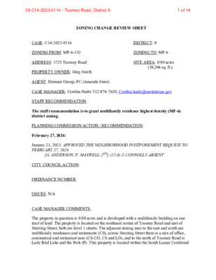
ZONING CHANGE REVIEW SHEET CASE: C14-2023-0114 DISTRICT: 9 ZONING FROM: MF-6-CO ZONING TO: MF-6 ADDRESS: 1725 Toomey Road PROPERTY OWNER: Greg Smith AGENT: Drenner Group, PC (Amanda Swor) SITE AREA: 0.90 acres (39,204 sq. ft.) CASE MANAGER: Cynthia Hadri 512-974-7620, Cynthia.hadri@austintexas.gov STAFF RECOMMENDATION: The staff recommendation is to grant multifamily residence highest density (MF-6) district zoning. PLANNING COMMISSION ACTION / RECOMMENDATION: February 27, 2024: January 23, 2023: APPROVED THE NEIGHBORHOOD POSTPONEMENT REQUEST TO FEBRUARY 27, 2024. [G. ANDERSON; F. MAXWELL-2ND] (12-0) J. CONNOLLY-ABSENT CITY COUNCIL ACTION: ORDINANCE NUMBER: ISSUES: N/A CASE MANAGER COMMENTS: The property in question is 0.90 acres and is developed with a multifamily building on one tract of land. The property is located on the southeast corner of Toomey Road and east of Sterzing Street, both are level 1 streets. The adjacent zoning uses to the east and south are multifamily residences and restaurants (CS), across Sterzing Street there is a mix of office, commercial and restaurant uses (CS-CO, CS and LO), and to the north of Toomey Road is Lady Bird Lake and the Park (P). This property is located within the South Lamar Combined 1 of 1409 C14-2023-0114 - Toomey Road; District 9 C14-2023-0000 2 Neighborhood Planning Area (Zilker Neighborhood) which does not have an adopted Future Land Use Map (FLUM). Please refer to Exhibits A (Zoning Map) and B (Aerial View). Staff is recommending the grant multifamily residence (highest density) - neighborhood plan (MF-6) district zoning and remove the existing conditional overlay (CO) which restricts the height to 75 feet. Staff is in agreement with the removal of height restriction as this is a reasonable use of the property at this location and it is in line with the City Council’s goals and initiatives to add more housing in the City. Please refer to Exhibit D (Existing Ordinance). The applicant is requesting to rezone the property from multifamily residence highest density-conditional overlay (MF-6-CO) combined district zoning to multifamily residence highest density (MF-6) district zoning to allow for a residential development with approximately 203 multifamily units. Due to the number of proposed residential units, an Educational Impact Statement (EIS) is required and was submitted with the application. The previous rezoning case submitted was for 215 units, more than the current request for 203 units. The previous EIS showed that the schools will be able to accommodate the projected additional student population from the proposed development. A traffic impact analysis (TIA) was not required per the TIA Determination Form. The TIA was not required because “the number of generated trips does not surpass the specified threshold. Please refer to Section 10.2.1 of the Transportation Criteria Manual for the relevant thresholds. Matters related to traffic management and other transportation-related items will undergo review during the site development permit process” per the transportation reviewer. The property is located 320 feet from Barton Springs Road and 0.30 miles from South Lamar Boulevard. Both streets are identified as level 1 streets, local mobility, in the Austin Strategic Mobility Plan and have CapMetro bus stops withing 0.25 miles of them. South Lamar and Barton Springs Road are both identified as Core Transit Corridors, also South Lamar is an Activity Corridor per the Imagine Austin Comprehensive Plan. Additionally, the property is adjacent to Butler Shores Metro Park, within a quarter mile of Zilker Park, the Butler Hike and Bike Trail and the Pfluger Pedestrian Bridge. Rezoning this property to MF-6 would provide increased residential opportunities near significant public spaces and within walking distance of existing and planned transit corridors. BASIS OF RECOMMENDATION: 1. The proposed zoning should be consistent with the purpose statement of the district sought. The multifamily residence highest density (MF-6) district is intended to accommodate multifamily and group residential use. This district is appropriate for highest density housing in centrally located areas near supporting transportation and commercial facilities, in areas adjoining downtown Austin and major institutional or employment centers, and in other selected areas where highest density multifamily use is desirable. 2 of 1409 C14-2023-0114 - Toomey Road; District 9 C14-2023-0000 3 2. Zoning should allow for reasonable use of the property. Multifamily residence highest density (MF-6) district zoning will allow for the proposed residential development and is suitable since it is consistent with the land uses in the surrounding area. Coldwater Luxury Apartments and Cole Apartments are both multifamily complexes on Toomey Road. 3. The proposed zoning should be consistent with the goals and objectives of the City Council. Both the Austin City Council and Planning Commission have articulated a principle to provide more housing in Austin. The rezoning of this property will allow for more multifamily units in central Austin. EXISTING ZONING AND LAND USES: Site North South East West LAND USES Multifamily Lady Bird Lake & Park Restaurants Multifamily Multifamily Office Commercial ZONING MF-6-CO P CS CS CS LO CS-CO SCENIC ROADWAY: Yes NEIGHBORHOOD PLANNING AREA: South Lamar Combined (Zilker (Suspended)) WATERSHED: Lady Bird Lake (Urban) CAPITOL VIEW CORRIDOR: No SCHOOLS: Austin Independent School District Zilker Elementary School O Henry Middle School COMMUNITY REGISTRY LIST: Austin Independent School District Austin Lost and Found Pets Austin Neighborhoods Council Friends of Austin Neighborhoods Friends of Zilker Homeless Neighborhood Association Neighborhood Empowerment Foundation Perry Grid 614 Preservation Austin SELTexas Save Our Springs Alliance Sierra Club Austin Regional Group South Central Coalition TNR BCP Travis County Natural Resources Zilker Neighborhood Association Austin High School 3 of 1409 C14-2023-0114 - Toomey Road; District 9 C14-2023-0000 4 AREA CASE HISTORIES: NUMBER C14-05-0186 REQUEST From CS to CS-CO C14-05-0189 From CS-CO & LO- CO to CS-CO C14-2008- 0060 Rezoning and changing the zoning map to add a vertical mixed use building (v) combining district. C14-01-0177 From CS to CS-1-CO C14-07-0018 From CS to MF-6 CITY COUNCIL Approved CS-CO; CO was to prohibit a set of land uses, restrict non-residential uses to a max. of 10,000 SF, and to limit the max. daily vehicle trips per day to less than 650 (3/1/2007). Approved CS-CO; CO was to prohibit a set of land uses, restrict non-residential uses to a max. of 10,000 SF, and to limit the max. daily vehicle trips per day to less than 650 (3/1/2007). Approved vertical mixed use building (V) with dimensional standards, parking reduction and additional uses in office districts. as Commission recommended (10/16/08). Approved staffs recommendation of CS-l-CO (05/23/2002). Approved MF-6-CO as Commission recommended (2/28/08). COMMISSION Approved staff’s recommendation of CS- CO; CO was to limit the max. daily vehicle trips per day to less than 650. Approved staff’s recommendation of CS- CO; CO was to limit the max. daily vehicle trips per day to less than 650. Approved vertical mixed use building (V) with dimensional standards, parking reduction and additional uses in office districts. (8/12/2008) Denied staffs recommendation of CS-l- CO (02/26/2002). Approved staff’s recommendation of MF-6- CO; CO was to limit height to 75 feet. The height limit for this property was an agreement between the applicant and the neighborhood, staff supported the agreement between the two parties. RELATED CASES: C14-2021-0009: The applicant requested to rezone from CS to MF-6-CO (as amended). Staff recommended MF-6. The case was forwarded to the City Council from the Planning Commission without a recommendation on October 26, 2021. The case was approved for second and third readings at City Council on January 27, 2022 (Ordinance No. 20220127- 068). 4 of 1409 C14-2023-0114 - Toomey Road; District 9 C14-2023-0000 5 ADDITIONAL STAFF COMMENTS: Comprehensive Planning: Monday October 2, 2023 Project Name and Proposed Use: 1725 TOOMEY ROAD. C14-2023-0114. 0.9014 acres from MF- 6-CO to MF-6. Demolishing 40 multifamily units and building 203 multifamily units in its place. Existing Conditional Overlay restricts height to 75 feet Yes Imagine Austin Decision Guidelines Complete Community Measures * Imagine Austin Growth Concept Map: Located within or adjacent to an Imagine Austin Activity Center, Imagine Austin Activity Corridor, or Imagine Austin Job Center as identified the Growth Concept Map. Names of Activity Centers/Activity Corridors/Job Centers: Y Mobility and Public Transit: Located within 0.25 miles of public transit stop and/or light rail station. Y Mobility and Bike/Ped Access: Adjoins a public sidewalk, shared path, and/or bike lane. Y Connectivity, Good and Services, Employment: Provides or is located within 0.50 miles to goods and services, and/or employment center. Connectivity and Food Access: Provides or is located within 0.50 miles of a grocery store/farmers market. Connectivity and Education: Located within 0.50 miles from a public school or university. Connectivity and Healthy Living: Provides or is located within 0.50 miles from a recreation area, park or walking trail. Connectivity and Health: Provides or is located within 0.50 miles of health facility (ex: hospital, urgent care, doctor’s office, drugstore clinic, and/or specialized outpatient care.) Housing Choice: Expands the number of units and housing choice that suits a variety of household sizes, incomes, and lifestyle needs of a diverse population (ex: apartments, triplex, granny flat, live/work units, cottage homes, and townhomes) in support of Imagine Austin and the Strategic Housing Blueprint. Housing Affordability: Provides a minimum of 10% of units for workforce housing (80% MFI or less) and/or fee in lieu for affordable housing. Mixed use: Provides a mix of residential and non-industrial uses. Culture and Creative Economy: Provides or is located within 0.50 miles of a cultural resource (ex: library, theater, museum, cultural center). Culture and Historic Preservation: Preserves or enhances a historically and/or culturally significant site. Creative Economy: Expands Austin’s creative economy (ex: live music venue, art studio, film, digital, theater.) Workforce Development, the Economy and Education: Expands the economic base by creating permanent jobs, especially in industries that are currently not represented in a particular area or that promotes a new technology, and/or promotes educational opportunities and workforce development training. Industrial Land: Preserves or enhances industrial land. Number of “Yes’s” Y Y Y Y Y 8 5 of 1409 C14-2023-0114 - Toomey Road; District 9 C14-2023-0000 6 Drainage: The developer is required to submit a pre- and post-development drainage analysis at the subdivision and site plan stage of the development process. The City’s Land Development Code and Drainage Criteria Manual requires that the Applicant demonstrate through engineering analysis that the proposed development will have no identifiable adverse impact on surrounding properties. Environmental: The site is not located over the Edwards Aquifer Recharge Zone. The site is located in the Lady Bird Lake Watershed of the Colorado River Basin, which is classified as an Urban Watershed by Chapter 25-8 of the City's Land Development Code. It is in the Desired Development Zone. Zoning district impervious cover limits apply in the Urban Watershed classification. According to floodplain maps there is a floodplain within or adjacent to the project location. Based upon the location of the floodplain, offsite drainage should be calculated to determine whether a Critical Water Quality Zone exists within the project location. Standard landscaping and tree protection will be required in accordance with LDC 25-2 and 25-8 for all development and/or redevelopment. At this time, site specific information is unavailable regarding vegetation, areas of steep slope, or other environmental features such as bluffs, springs, canyon rimrock, caves, sinkholes, and wetlands. This site is required to provide on-site water quality controls (or payment in lieu of) for all development and/or redevelopment when 8,000 s.f. cumulative is exceeded, and on site control for the two-year storm. At this time, no information has been provided as to whether this property has any preexisting approvals that preempt current water quality or Code requirements. Fire: Based on meeting with applicant TIA/AFD coordination can be deferred to the Site Plan phase. PARD – Planning & Design Review: Parkland dedication will be required for the new residential units proposed by this development, multifamily with MF-6 zoning (removal of CO), at the time of subdivision or site plan, per City Code § 25-1-601. Whether the requirement shall be met with fees in-lieu or dedicated land will be determined using the criteria in City Code Title 25, Article 14, as amended. Should fees in-lieu be required, those fees shall be used toward park investments in the form of land acquisition and/or park amenities within the surrounding area, per the Parkland Dedication Operating Procedures § 14.3.11 and City Code § 25-1-607 (B)(1) & (2). 6 of 1409 C14-2023-0114 - Toomey Road; District 9 C14-2023-0000 7 If the applicant wishes to discuss parkland dedication requirements in advance of site plan or subdivision applications, please contact this reviewer: thomas.rowlinson@austintexas.gov. At the applicant’s request, PARD can provide an early determination of whether fees in-lieu of land will be allowed. Site Plan: Site plans will be required for any new development other than single-family or duplex residential. Any development which occurs in an SF-6 or less restrictive zoning district which is located 540-feet or less from property in an SF-5 or more restrictive zoning district will be subject to compatibility development regulations. Any new development is subject to Subchapter E. Design Standards and Mixed Use. Additional comments will be made when the site plan is submitted. This tract is already developed, and the proposed zoning change is a footprint within the existing development. FYI this tract is in the Butler Shores waterfront overlay. Austin Transportation Department – Engineering Review: Assessment of required transportation mitigation, including the potential dedication of right of way and easements and participation in roadway and other multi-modal improvements, will occur at the time of site plan application. The traffic impact analysis for this site is not required, the traffic generated by the proposal does not exceed the thresholds established in the City of Austin Land Development Code. [LDC 25-6-113]. The Austin Strategic Mobility Plan (ASMP) calls for 58 feet of right-of-way for STERZING ST. It is recommended that 29 feet of right-of-way from the existing centerline should be dedicated for STERZING ST according to the Transportation Plan with the first subdivision or site plan application. [LDC 25-6-51 and 25-6-55]. Toomey Road has sufficient right of way to comply with the Austin Strategic Mobility Plan (ASMP). [LDC 25-6-51 and 25-6-55]. Existing Street Characteristics: Name ASMP Classification Existing ROW Existing Pavement Sidewalks Bicycle Route Capital Metro (within ¼ mile) STERZING ST Local Mobility - Level 1 50 feet 29 feet No Shared lane (on-street) Yes ASMP Required ROW 58 feet 7 of 1409 C14-2023-0114 - Toomey Road; District 9 C14-2023-0000 TOOMEY RD Local Mobility - Level 1 58 feet 61 feet 29 feet No 8 Shared lane (on-street) Yes TIA: It is not required. Austin Water Utility: No comments on zoning change. The landowner intends to serve the site with existing City of Austin water utilities. Depending on the development plans submitted, water and or wastewater service extension requests may be required. All water and wastewater construction must be inspected by the City of Austin. For more information pertaining to the Service Extension Request process and submittal requirements contact the Austin Water SER team at ser@austintexas.gov. INDEX OF EXHIBITS AND ATTACHMENTS TO FOLLOW: A. Zoning Map B. Aerial Map C. Applicant’s Summary Letter D. Existing Ordinance 8 of 1409 C14-2023-0114 - Toomey Road; District 9 RE SE RV E RD TOWNE LAKE PARK P-NP P-NP W C E S A C14-02-0112 R C H AV EZ ST LI-NP LI-CO-NP S P C 9 2-0 0 3 1 C 88-0033 02-0112 L O U N E F F R D 87-112 P SOCCER FIELDS P SPC-05-0023C B A R T O N S P R I N G S R D A N D R E W Z I L K E R R D P P D N R O T R O ZIE M A SF-3 05-0189 CS-V-CO C14-05-0189 SP-2007-0412C C14-05-0186 CS-CO C 6 44 5-0 P9 S T G S ZIN R E ST ! SP95-0161C ETAIL CS R VACT\REST C14-2008-0060 LO OFF. ! ! ! ! S T N E M T R PA A ! ! 05-0186 ! ! MF-6-CO ! ! C14-2021-0009 ! ! K R A V P R ! ! ! ! P O H G S VIN A R G N E C14-2008-0060 T. S E R CS CS S U N S ET V W ( G A S S T A . CS *99-2103 C L E A N E R S C14-2018-0017 SF-3 SF-3 ( ( ( SF-3 ( ( R R D E AT SF-3 C C14-2011-0078 M E G H A N L N ( C O F F E E C14-2008-0060 E BIK BUTLER PARK P 87-074 TO O M E Y R D K R A V P R E R A AY C D S E FIC F O CS S B 90 0 P-93-0 S RZ86-069 PA R KIN G SP91-0250C T. S E R C14-2008-0060 CS-1 S P-91-0012 S P91-0251 C C C 40 2 P-89-0 S T. S E R T. S E R C 07 3 S E FIC F O S P-04-0 C14-01-0177 7 7 1 1-0 0 K R R.V. PA K R R.V. PA M/H C14-2008-0060 C14-07-0018 MF-6-CO 07-0018 MOBILE HOM ES C.O.A. OFFICE P.A.R.D. SPC89-0143C 72-129 THEATER CS-1 SPC89-0143C PAR KIN G CS PUD C14-2008-0060 C814-2018-0121 S K R A C.O.A. P E S H W GLASS CO. CS-V C14-2008-0060 E R O T V. S N O C T. S E R GAS SP-00-2213C C14-2008-0060 REST. W H S E B U TLE R R D S A L O N SALON T SIE S S JE V. E N R O O C T S CS-V O T O H P CS-1 G KIN R PA R E T N E P R A C 5 8 1 - 5 8 P S 5 8 T E S HIN P-85-1 P E S JO S CS O F C. C14-2008-0060 T. S E R C14-2008-0060 CS-V GAS CS C14-68-274 P81-053 MF-5 C14-2008-0060 ( ( OFC. *99-2041 ( ( LR P81-079 SP85-057 ( APTS ( ( OFC SP95-0001C SP-06-0498C C14-71-135 HIL L M ( ( ( SF-3 O N T S T ( ( ( ( ( T S I E S ( ( ( SF-3 S E J ( ( ( ( ( ( ( ( ( ZONING D V L B R A M A L S FAST FOOD 58-084 ! ! C14-2008-0060 ! ! CS-V ! ! ! !! !! ! ! ! ! ( ( CS ! ! ! ! ZONING CASE#: C14-2023-0114 D ELI R E S TA U R A N T A. T S S A G B S D V L B R A M A L S B N D V L B R A M A L S CS-V CS-1-V G KIN R A P C14-2008-0060 CS-V P FAST FOOD R D N O T R A B E E L 50-113 CS C14-02-0031 ! ! ! ! ! This product is for informational purposes and may not have been prepared for or be suitable for legal, engineering, or surveying purposes. It does not represent an on-the-ground survey and represents only the approximate relative location of property boundaries. This product has been produced by the Housing and Planning Department for the sole purpose of geographic reference. No warranty is made by the City of Austin regarding specific accuracy or Created: 10/3/2023 ( ( ( ( ( ( ( D V L N B O T R A B ( SF-3-H ( ( SF-3 ( ( ( ( SF-3 ( ( ( ( ( ( T D S R O FF O P S ( ( ( ( ( ( ( ( R F D LIF C ( ( ( ( ( ( ( ( SF-3 ( ( ( ( SF-3 ( SF-3-H VIR ( ( ( GINIA AV ( E ( ( ( ( ( ( ( ( ( SF-3 ( ( LIN S C ( ( ( O M B A V E ( ( ( ( ( ( ( ( SF-3 ( ( ( ( ( E V R A E N R A G ( ( ( ( ( ( SF-3 ( ( E V Y A E N KIN SF-3 ( ( ( ( ( JULIE ( SF-3 T ST ( ( ( ( ( ( ( ( ( ( SUBJECT TRACT ! ! ! ! ! ! PENDING CASE ZONING BOUNDARY KE R R ST ( ( ± 1 " = 400 ' Exhibit A 9 of 1409 C14-2023-0114 - Toomey Road; District 9 Exhibit B !!!!!!!!!!!!!!!!!!!!!!!!!!!!!(!(!(!(!(!(!(!(!(!(!(!(!(!(!(!(!(!(!(!(!(!(!(!(!(!(!(!(!(!(!(!(!(!(!(!(!(!(!(!(!(!(!(!(!(!(!(!(!(!(!(!(!(!(!(!(!(!(!(!(!(!(!(!(!(!(!(!(!(!(!(!(!(!(!(!(!(!(!(!(!(!(!(!(!(!(!(!(!(!(!(!(!(!(!(!(!(!(!(!(!(!(!(!(!(!(!(!(!(!(!(!(!(!(!(!(!(!(!(!(!(!(!(!(!(!(!(!(!(!(H22H21C14-2023-0114C14-02-0112C14-2008-0060C14-07-0018C14-2008-0060C14-2008-0060C14-2008-0060C14-2008-0060C14-2008-0060C14-2008-0060C814-2018-0121C14-2008-0060C14-2021-0009C14-05-0186C14-2008-0060C14-2008-0060C14-01-0177C14-2008-0060C14-05-0189C14-2008-0060C14-2008-0060C14-2018-0017C14-2011-0078C14-02-0031TOOMEYRDBARTONBLVDLOUNEFFRDKINNEYAVEJESSIESTAZIEMORTONRDCLIFFDRLINSCOMBAVEWCESARCHAVEZSTSLAMARBLVDSBVIRGINIAAVESLAMARBLVDNBBUTLERRDSTERZINGSTBARTONSPRINGSRDGARNERAVEMEGHANLNSPOFFORDSTJULIETSTKERRSTHILLMONTSTJOSEPHINESTSLAMARBLVDLEEBARTONDRSUNSETVWCATERDRANDREWZILKERRDRESERVE RDJESSIESTPPPCSPPSF-3P-NPP-NPCSLRSF-3SF-3SF-3CSSF-3CSMF-5SF-3SF-3SF-3SF-3SF-3SF-3CSMF-6-COCS-VCSCS-VPUDCSCSCSCS-VCS-VLI-CO-NPSF-3LOSF-3SF-3-HSF-3-HCS-COCSSF-3CS-VCS-1CS-1SF-3LI-NPCS-V-COMF-6-COSF-3CS-VCS-1PCS-1-V1725 Toomey±This product has been produced by the Planning Department for the sole purpose of geographic reference. No warrantyis made by the City of Austin regarding specific accuracy or completeness.ZONING CASE#:LOCATION:SUBJECT AREA:GRID:MANAGER:C14-2023-01141725 Toomey Rd0.9014 AcresH22Cynthia HadriCreated: 10/31/2023SUBJECT TRACTZONING BOUNDARY!!!!!!PENDING CASECREEK BUFFER0200400600800100Feet10 of 1409 C14-2023-0114 - Toomey Road; District 9 Amanda Swor direct dial: (512) 807-2904 aswor@drennergroup.com September 20, 2023 Via Electronic Delivery Ms. Lauren Middleton-Pratt Planning Department City of Austin 1000 E. 11th Street, Ste 200 Austin, TX 78702 Dear Ms. Middleton-Pratt: Re: 1725 Toomey – Rezoning application for the 0.9014-acre piece of property located at 1725 Toomey Road in Austin, Travis County, Texas (the “Property”) As representatives of the owner of the Property, we respectfully submit the enclosed rezoning application package. The project is titled 1725 Toomey, consists of 0.9014 acres, and is located at 1725 Toomey Road at the southeast corner of Toomey Road and Sterzing Street intersection. The current use of the Property is multifamily residential with approximately 40 existing units. The Property is currently zoned MF-6-CO, Multifamily Residence Highest Density – Conditional Overlay, district. The requested rezoning is from MF-6-CO to MF-6 district. This rezoning is requested to allow a residential development with approximately 203 multifamily units, and to remove the existing Conditional Overlay which restricts the height of the Property to 75 feet. This request is consistent with surrounding uses. The Property is located in the South Lamar Combined Neighborhood Planning Area and specifically in the Zilker Neighborhood. This neighborhood plan has not yet been formally adopted by the City of Austin, and planning has been suspended indefinitely. Therefore, the Property also does not have a Future Land Use Map (“FLUM”) designation. A Traffic Impact Analysis (“TIA”) is not required per a TIA Determination Form signed by Amber Hutchens, dated July 20, 2023. A TIA is not required because the traffic generated by the proposal does not exceed the thresholds established in the Land Development Code. Exhibit C 11 of 1409 C14-2023-0114 - Toomey Road; District 9 Please let me know if you or your team members require additional information or have any questions. Thank you for your time and attention to this project. Very truly yours, Amanda Swor cc: Joi Harden, Planning Department (via electronic delivery) Exhibit C -2- 12 of 1409 C14-2023-0114 - Toomey Road; District 9 ORDINANCE NO. 20220127-068 AN ORD NANCE REZON NG AND CHANGING THE ZONING MAP FOR THE PROPERTY LOCATED AT 1725 TOOMEY ROAD FROM GENERAL COMMERCIAL SERVICES (CS) DISTRICT TO MULTIFAMILY RESIDENCE HIGHEST DENSITY-CONDITIONAL OVERLAY (MF-6-CO) COMBINING DISTRICT. BE IT ORDAINED BY THE CITY COUNCIL OF THE CITY OF AUSTIN: PART 1. The zoning map established by Section 25-2-191 of the City Code is amended to change the base district from general commercial services (CS) district to multifamily residence highest density-conditional overlay (MF-6-CO) combining district on the property described in Zoning Case No. C 14-2021-0009, on file at the Housing and Planning Department, as follows: Being 0.090 acres of land, more or less, out of the Isaac Decker Survey, Abstract No. 8, Travis County, Texas, being those tracts called Tracts 1-3 as conveyed to Beyond Investments, LLC, by deed recorded in Document No. 2019011624, Official Public Records of Travis County, Texas, said 0.090 acres of land being more particularly described by metes and bounds in Exhibit "A" incorporated into this ordinance (the "Property locally known as 1725 Toomey Road in the City of Austin, Travis County, Texas, generally identified in the map attached as Exhibit "B". PART 2. The Property within the boundaries of the conditional overlay combining district established by this ordinance is subject to the following conditions: (A) The maximum height of building or structure on the Property shall not exceed 75 feet. (B) A vegetative buffer shall be provided and maintained along the north property line consistent with the primary setback area as defined in City Code Section 25- 2-733(B) (Butler Shores Subdistrict Regulations). Fences, railings or barriers may not be erected in the buffer area. Improvements permitted within the buffer zone are limited to drainage, underground utility improvements or those improvements that may be otherwise required by the City of Austin or specifically authorized in this ordinance. (C) Benches may be located in the vegetative buffer area. Page 1 0 f 2 Exhibit D 13 of 1409 C14-2023-0114 - Toomey Road; District 9 (D) Vehicular access from the Property to Toomey Road is prohibited unless, at the time of site plan, the city manager requires access for traffic safety reasons. (E) The Property shall not be used as a Type 3 short-term rental described in City Code Section 25-2-790 (Short-term rental (Type 3) Regulations). PART 3. Except as specifically restricted under this ordinance, the Property may be developed and used in accordance with the regulations established for the multifamily residence highest density (MF-6) district and other applicable requirements of the City Code. PART 4. This ordinance takes effect on February 7,2022. PASSED AND APPROVED January 27 ,2022 § f§ § Ste?/e Adl r Mayor APPROVED: l_ Anne L. Morgan City Attorney ATTEST: 06&4 4- Myrnillios City Clerk Page 2 of 2 Exhibit D 14 of 1409 C14-2023-0114 - Toomey Road; District 9