07 NPA-2021-0010.01 - 2400 E. Cesar Chavez Parking Expansion; District 3.pdf — original pdf
Backup
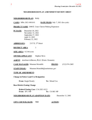
Planning Commission: December 20, 2022 NEIGHBORHOOD PLAN AMENDMENT REVIEW SHEET DATE FILED: July 7, 2021 (In-cycle) NEIGHORHOOD PLAN: Holly CASE#: NPA-2021-0010.01 PROJECT NAME: 2400 E. Cesar Chavez Parking Expansion PC DATE: December 20, 2022 November 15, 2022 September 27, 2022 April 12, 2022 February 22, 2022 3 2317 E. 2nd Street ADDRESS/ES: DISTRICT AREA: SITE AREA: 0.2146 acres OWNER/APPLICANT: Stephen Neva AGENT: Armbrust & Brown, PLLC (Ferris Clements) CASE MANAGER: Maureen Meredith STAFF EMAIL: Maureen.Meredith@austintexas.gov TYPE OF AMENDMENT: Change in Future Land Use Designation To: Mixed Use From: Single Family Base District Zoning Change Related Zoning Case: C14-2021-0121 From: SF-3-NP NEIGHBORHOOD PLAN ADOPTION DATE: CITY COUNCIL DATE: TBD ACTION: PHONE: (512) 974-2695 To: CS-MU-NP December 13, 2001 1 of 317 Planning Commission: December 20, 2022 PLANNING COMMISSION RECOMMENDATION: December 20, 2022 – November 15, 2022 - Postponed to December 20, 2022 on the consent agenda at the request of staff. [A. Azhar – 1st; J. Thompson -2nd] Vote: 9-0 [G. Cox, R. Schneider, and J. Shieh absent. One vacancy on the dais.] September 27, 2022 – Postponed to November 15, 2022 at the request of the applicant on the consent agenda. [C. Hempel -1st; G. Cox – 2nd] Vote: 9-0 [J. Mushtaler, J. Thompson, and R. Schneider absent]. One vacancy on the dais. April 12, 2022 – Approved the applicant’s request for an indefinite postponement on the consent agenda. [C. Hempel – 1st; R. Schneider – 2nd] Vote: 10-0 [A. Azhar, G. Cox and J. Connolly absent]. February 22, 2022 – Postponed to April 12, 2022 on the consent agenda at the request of staff. [A. Azhar – 1st; J. Shieh – 2nd] Vote: 13-0. STAFF RECOMMENDATION: Recommended for the applicant’s request for Mixed Use land use. BASIS FOR STAFF’S RECOMMENDATION: Staff supports the applicant’s request for Mixed Use land use because Mixed Use land use is currently on property to the west. There is Multifamily Residential land use to the north and Mixed Use land use to the south along E. Cesar Chavez Street. The subject property is directly north of E. Cesar Chavez Street which is an Activity Corridor where mixed use is appropriate. Multifamily Residential Single Family Mixed Use 2 2 of 317 Planning Commission: December 20, 2022 LAND USE DESCRIPTIONS EXISTING LAND USE ON THE PROPERTY Single family - Detached or two family residential uses at typical urban and/or suburban densities. Purpose 1. Preserve the land use pattern and future viability of existing neighborhoods; 2. Encourage new infill development that continues existing neighborhood patterns of development; and 3. Protect residential neighborhoods from incompatible business or industry and the loss of existing housing. Application 1. Existing single‐family areas should generally be designated as single family to preserve established neighborhoods; and 2. May include small lot options (Cottage, Urban Home, Small Lot Single Family) and two‐family residential options (Duplex, Secondary Apartment, Single Family Attached, Two‐Family Residential) in areas considered appropriate for this type of infill development. PROPOSED LAND USE ON THE PROPERTY Mixed Use - An area that is appropriate for a mix of residential and non‐residential uses. Purpose 1. Encourage more retail and commercial services within walking distance of residents; 2. Allow live‐work/flex space on existing commercially zoned land in the neighborhood; 3. Allow a mixture of complementary land use types, which may include housing, retail, offices, commercial services, and civic uses (with the exception of government offices) to encourage linking of trips; 4. Create viable development opportunities for underused center city sites; 5. Encourage the transition from non‐residential to residential uses; 6. Provide flexibility in land use standards to anticipate changes in the marketplace; 3 3 of 317 Planning Commission: December 20, 2022 7. Create additional opportunities for the development of residential uses and affordable housing; and 8. Provide on‐street activity in commercial areas after 5 p.m. and built‐in customers for local businesses. Application 1. Allow mixed use development along major corridors and intersections; 2. Establish compatible mixed‐use corridors along the neighborhood’s edge 3. The neighborhood plan may further specify either the desired intensity of commercial uses (i.e. LR, GR, CS) or specific types of mixed use (i.e. Neighborhood Mixed Use Building, Neighborhood Urban Center, Mixed Use Combining District); 4. Mixed Use is generally not compatible with industrial development, however it may be combined with these uses to encourage an area to transition to a more complementary mix of development types; 5. The Mixed Use (MU) Combining District should be applied to existing residential uses to avoid creating or maintaining a non‐conforming use; and 6. Apply to areas where vertical mixed use development is encouraged such as Core Transit Corridors (CTC) and Future Core Transit Corridors. Yes Imagine Austin Decision Guidelines Yes Complete Community Measures Imagine Austin Growth Concept Map: Located within or adjacent to an Imagine Austin Activity Center, Imagine Austin Activity Corridor, or Imagine Austin Job Center as identified the Growth Concept Map. Name(s) of Activity Center/Activity Corridor/Job Center: • Directly north of E. Cesar Chavez a designated Activity Corridor Yes Mobility and Public Transit: Located within 0.25 miles of public transit stop and/or light rail station. • There are bus routes along E. 2nd Street and E. Cesar Chavez St. Yes Mobility and Bike/Ped Access: Adjoins a public sidewalk, shared path, and/or bike lane. • There are sidewalks on the north and south sides of E. 2nd Street. Yes Connectivity, Good and Services, Employment: Provides or is located within 0.50 miles to goods and services, and/or employment center. Yes Connectivity and Food Access: Provides or is located within 0.50 miles of a grocery store/farmers market. Yes Connectivity and Education: Located within 0.50 miles from a public school or university. • Zavala Elementary School is 0.3 miles from the property Yes Connectivity and Healthy Living: Provides or is located within 0.50 miles from a recreation area, park or walking trail. • Pan America Neighborhood Park is 0.3 miles from the property Connectivity and Health: Provides or is located within 0.50 miles of health facility (ex: hospital, urgent care, doctor’s office, drugstore clinic, and/or specialized outpatient care.) Housing Affordability: Provides a minimum of 10% of units for workforce housing (80% MFI or less) and/or fee in lieu for affordable housing. Housing Choice: Expands the number of units and housing choice that suits a variety of household sizes, incomes, and lifestyle needs of a diverse population (ex: apartments, triplex, granny flat, live/work units, 4 4 of 317 Planning Commission: December 20, 2022 cottage homes, and townhomes) in support of Imagine Austin and the Strategic Housing Blueprint. Mixed use: Provides a mix of residential and non-industrial uses. Culture and Creative Economy: Provides or is located within 0.50 miles of a cultural resource (ex: library, theater, museum, cultural center). Culture and Historic Preservation: Preserves or enhances a historically and/or culturally significant site. Creative Economy: Expands Austin’s creative economy (ex: live music venue, art studio, film, digital, theater.) Workforce Development, the Economy and Education: Expands the economic base by creating permanent jobs, especially in industries that are currently not represented in particular area or that promotes a new technology, and/or promotes educational opportunities and workforce development training. Industrial Land: Preserves or enhances industrial land. Yes Number of “Yes’s” Imagine Austin Priority Program PUD Specific Bonus Features Public Space Features and Public Art: Incorporates public space features and/or public art into project (Ex: plazas, streetscapes, gardens, and other people-friendly spaces where different ages can socially interact). Integrates and/or Expands Green Infrastructure: Preserves or expands Austin’s green infrastructure (ex: parkland, community gardens, green streets, creeks, stormwater features that mimic natural hydrology) into the urban environment and transportation network. Protects the Environment: Reduces greenhouse gas emissions, water, energy usage, and/or increases waste diversion. Protects Environmentally Sensitive Lands: Protects Austin’s natural resources and environmental systems by limiting land use and transportation development over or near environmentally sensitive areas, preserves open space, and protects natural resources more than ordinance requirements. Water/Wastewater Infrastructure: Sustainably manages Austin’s water resources and stream corridors through on-site use of storm water, effective landscaping, flood mitigation, and other low-impact development techniques more than ordinance requirements. Total Number of “Yes’s” 5 5 of 317 Planning Commission: December 20, 2022 Proximity to Imagine Austin Activity Corridors and Centers 6 6 of 317 Planning Commission: December 20, 2022 Proximity to Public Parks 7 7 of 317 Planning Commission: December 20, 2022 Proximity to Public Transportation IMAGINE AUSTIN GROWTH CONCEPT MAP Definitions Neighborhood Centers - The smallest and least intense of the three mixed-use centers are neighborhood centers. As with the regional and town centers, neighborhood centers are walkable, bikable, and supported by transit. The greatest density of people and activities in neighborhood centers will likely be concentrated on several blocks or around one or two intersections. However, depending on localized conditions, different neighborhood centers can be very different places. If a neighborhood center is designated on an existing commercial area, such as a shopping center or mall, it could represent redevelopment or the addition of housing. A new neighborhood center may be focused on a dense, mixed-use core surrounded by a mix of housing. In other instances, new or redevelopment may occur incrementally and concentrate people and activities along several blocks or around one or two intersections. Neighborhood centers will be more locally focused than either a regional or a town center. Businesses and services—grocery and department stores, doctors and dentists, shops, branch libraries, dry cleaners, hair salons, schools, restaurants, and other small and local businesses—will generally serve the center and surrounding neighborhoods. 8 8 of 317 Planning Commission: December 20, 2022 Town Centers - Although less intense than regional centers, town centers are also where many people will live and work. Town centers will have large and small employers, although fewer than in regional centers. These employers will have regional customer and employee bases, and provide goods and services for the center as well as the surrounding areas. The buildings found in a town center will range in size from one-to three-story houses, duplexes, townhouses, and rowhouses, to low-to midrise apartments, mixed use buildings, and office buildings. These centers will also be important hubs in the transit system. Regional Centers - Regional centers are the most urban places in the region. These centers are and will become the retail, cultural, recreational, and entertainment destinations for Central Texas. These are the places where the greatest density of people and jobs and the tallest buildings in the region will be located. Housing in regional centers will mostly consist of low to high-rise apartments, mixed use buildings, row houses, and townhouses. However, other housing types, such as single-family units, may be included depending on the location and character of the center. The densities, buildings heights, and overall character of a center will depend on its location. Activity Centers for Redevelopment in Sensitive Environmental Areas - Five centers are located over the recharge or contributing zones of the Barton Springs Zone of the Edwards Aquifer or within water-supply watersheds. These centers are located on already developed areas and, in some instances, provide opportunities to address long-standing water quality issues and provide walkable areas in and near existing neighborhoods. State-of-the-art development practices will be required of any redevelopment to improve stormwater retention and the water quality flowing into the aquifer or other drinking water sources. These centers should also be carefully evaluated to fit within their infrastructural and environmental context. Job Centers - Job centers accommodate those businesses not well-suited for residential or environmentally- sensitive areas. These centers take advantage of existing transportation infrastructure such as arterial roadways, freeways, or the Austin-Bergstrom International airport. Job centers will mostly contain office parks, manufacturing, warehouses, logistics, and other businesses with similar demands and operating characteristics. They should nevertheless become more pedestrian and bicycle friendly, in part by better accommodating services for the people who work in those centers. While many of these centers are currently best served by car, the growth Concept map offers transportation choices such as light rail and bus rapid transit to increase commuter options. Corridors - Activity corridors have a dual nature. They are the connections that link activity centers and other key destinations to one another and allow people to travel throughout the city and region by bicycle, transit, or automobile. Corridors are also characterized by a variety of activities and types of buildings located along the roadway — shopping, restaurants and cafés, parks, schools, single-family houses, apartments, public buildings, houses of worship, mixed-use buildings, and offices. Along many corridors, there will be both large and small redevelopment sites. These redevelopment opportunities may be continuous along stretches of the corridor. There may also be a series of small neighborhood centers, connected by the roadway. Other corridors may have fewer redevelopment 9 9 of 317 Planning Commission: December 20, 2022 opportunities, but already have a mixture of uses, and could provide critical transportation connections. As a corridor evolves, sites that do not redevelop may transition from one use to another, such as a service station becoming a restaurant or a large retail space being divided into several storefronts. To improve mobility along an activity corridor, new and redevelopment should reduce per capita car use and increase walking, bicycling, and transit use. Intensity of land use should correspond to the availability of quality transit, public space, and walkable destinations. Site design should use building arrangement and open space to reduce walking distance to transit and destinations, achieve safety and comfort, and draw people outdoors. BACKGROUND: This plan amendment application was filed on July 7, 2021, which is in- cycle for neighborhood planning areas located on the east side of IH-35. The applicant proposes the change the future land use map from Single Family to Mixed use land use. The applicant proposes to change the zoning on the property from SF-3-NP (Family Residence district-Neighborhood Plan) to CS-MU-NP (General Commercial Services district – Mixed Use Combining District – Neighborhood Plan) to build a parking lot to provide additional parking for surround businesses. For more information on the proposed zoning, see case report C14-2021-0121. PUBLIC MEETINGS: The ordinance-required community meeting was held on August 16, 2021. The recorded meeting can be found at https://www.speakupaustin.org/npa. Approximately 902 community meeting notices were mailed to people who rent or own property within 500 feet of the property, in addition to neighborhood and environmental groups who requested notification for the area on the Community Registry. Two staff members from the Housing and Planning Department attended the meeting, Jesse Gutierrez and Maureen Meredith. Also in attendance was Ferris Clements from Armbrust and Brown, the applicant’s agent with Neville Rhone, Jr. and Daniel Fine from ARC Capital Partners, who are the applicants. Two people from the neighborhood were in attendance. After staff gave a brief presentation on the proposed plan amendment request, Ferris Clements, the applicant’s agent, provided the following information: • The property is located off 2nd Street. • The current land use on the future land use map is Single Family and the proposed land use is Mixed Use • The purpose is to expand parking lot by the nearby development. There is a lack of parking for tenants, employees, and customers. We purchased this property to expand the parking by 16-20 parking spaces. This goal is to take the pressure off parking on the street. • There will be a buffer between the parking lot and the neighborhood house to east. • We are minority owned firm focused on mixed use developments. We have local tenants. 10 10 of 317 After the presentation, no questions were asked. Planning Commission: December 20, 2022 11 11 of 317 Applicant Summary Letter from Application Planning Commission: December 20, 2022 12 12 of 317 Planning Commission: December 20, 2022 13 13 of 317 Planning Commission: December 20, 2022 14 14 of 317 Planning Commission: December 20, 2022 Letter of Recommendation from the Neighborhood Plan Contact Team (Holly Neighborhood Planning Area does not have a Neighborhood Plan Contact Team) 15 15 of 317 Planning Commission: December 20, 2022 16 16 of 317 Planning Commission: December 20, 2022 17 17 of 317 Planning Commission: December 20, 2022 18 18 of 317 Planning Commission: December 20, 2022 19 19 of 317 Planning Commission: December 20, 2022 20 20 of 317 Planning Commission: December 20, 2022 21 21 of 317 Planning Commission: December 20, 2022 Subject Property: 2317 E. 2nd Street 22 22 of 317 Planning Commission: December 20, 2022 23 23 of 317 Planning Commission: December 20, 2022 24 24 of 317 Planning Commission: December 20, 2022 25 25 of 317 Planning Commission: December 20, 2022 26 26 of 317 Planning Commission: December 20, 2022 27 27 of 317 Planning Commission: December 20, 2022 28 28 of 317 Planning Commission: December 20, 2022 29 29 of 317 Planning Commission: December 20, 2022 Correspondence Received From: Mark Foohey Sent: Tuesday, September 20, 2022 9:52 AM To: Meredith, Maureen <Maureen.Meredith@austintexas.gov> Subject: Case Number: NPA-2021-0010.01 *** External Email - Exercise Caution *** Dear Ms. Meredith, I am writing to object to the proposed future land use designation of this property. I have a property at 2502 E. 2nd Street that is caddycorner from this property. There is already quite a bit of commercial property in the immediate area and I don't want to see more single family homes displaced with commercial or mixed use property and further degrade the neighborhood quality. In fact, I believe this is planned to be turned into parking. Definitely not something I want to see in the neighborhood. Thanks, Mark Foohey 2502 E. 2nd St Austin, TX 78702 30 30 of 317 Planning Commission: December 20, 2022 31 31 of 317