17 C14-2022-0001 - 2409 Town Lake Circle; District 3.pdf — original pdf
Backup
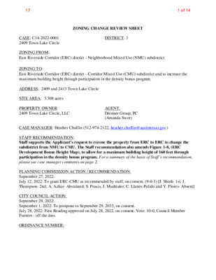
ZONING CHANGE REVIEW SHEET DISTRICT: 3 AGENT: Drenner Group, PC (Amanda Swor) CASE: C14-2022-0001 2409 Town Lake Circle ZONING FROM: East Riverside Corridor (ERC) district - Neighborhood Mixed Use (NMU) subdistrict ZONING TO: East Riverside Corridor (ERC) district - Corridor Mixed Use (CMU) subdistrict and to increase the maximum building height through participation in the density bonus program. ADDRESS: 2409 and 2413 Town Lake Circle SITE AREA: 3.308 acres PROPERTY OWNER: 2409 Town Lake Circle, LLC CASE MANAGER: Heather Chaffin (512-974-2122, heather.chaffin@austintexas.gov) STAFF RECOMMENDATION: Staff supports the Applicant’s request to rezone the property from ERC to ERC to change the subdistrict from NMU to CMU. The Staff recommendation also amends Figure 1-8, (ERC Development Bonus Height Map), to allow for a maximum building height of 160 feet through participation in the density bonus program. For a summary of the basis of Staff’s recommendation, please see case manager comments on page 2. PLANNING COMMISSION ACTION / RECOMMENDATION: September 27, 2022: July 12, 2022: To grant ERC-CMU as recommended by staff, on consent. (9-0-1) [J. Shieh- 1st, J. Thompson- 2nd; A. Azhar- Abstained; S. Praxis, J. Mushtaler, C. Llanes-Pulido and Y. Flores- Absent] CITY COUNCIL ACTION: September 29, 2022: September 1, 2022: To postpone to September 29, 2033, on consent. July 28, 2022: First Reading approved on July 28, 2022, on consent. Vote: 10-0, Council Member Fuentes - off the dais. ORDINANCE NUMBER: 1 of 1417 C14-2022-0001 2 ISSUES: The rezoning request from ERC to ERC to change the subdistrict from NMU to CMU was approved on July 12, 2022 on consent by Planning Commission. It was determined that additional language about participation in the density bonus program and potential height increase to 160 feet required an additional review by Planning Commission. CASE MANAGER COMMENTS: The subject property is located on the south side of Town Lake Circle in the East Riverside Corridor (ERC) planning area. The property is in the Neighborhood Mixed Use (NMU) subdistrict and is developed with 120 multifamily units that are approximately 36 years old. All other properties on the same side of Town Lake Circle are also developed with multifamily land uses. While the subject property and the property immediately to the west are in the NMU subdistrict, the remainder of the properties on the street are in the Corridor Mixed Use (CMU) subdistrict. Across Town Lake Circle is property that was previously developed with apartments that were demolished in 2008-2010 that is also in the CMU subdistrict. To the east and southeast of the subject property (along Pleasant Valley Drive) are other CMU subdistrict properties that include multifamily land use, undeveloped property, and retail-limited (HEB grocery) land uses. To the west and southwest (along East Riverside Drive) are properties that are in the NMU and CMU subdistricts. These properties are developed with commercial shopping centers with uses including restaurant-limited, retail, pawn shop and other uses. Please see Exhibits A, B, and C- Zoning Map, Aerial Exhibit and ERC Subdistrict Map. The ERC Regulating Plan states that the NMU subdistrict that is currently designated for the subject property, “provides for mid-rise residential with neighborhood-oriented retail and smaller employers. It is intended to have opportunities for attached residential and smaller-scale commercial uses.” The Regulating Plan also states that the proposed CMU subdistrict, “is the highest density district designation within the East Riverside Corridor and will typically consist of mixed use buildings such as residential or office uses over retail or office ground floor uses. The ground floors of these buildings are envisioned to be primarily retail or office while upper floors may be office and/or residential. Mixed use development is key within this subdistrict because it will help to create a walkable environment with a variety of land uses located in a compact area.” Correspondence has been received in opposition to the rezoning request. Please see Exhibit D- Correspondence. Staff supports the requested change from the NMU subdistrict to the CMU subdistrict of the East Riverside Corridor planning area and to increase the maximum building height through participation in the density bonus program. The majority of surrounding properties are in the CMU subdistrict, making the change consistent with similarly situated properties. The property lies between an ERC Core Transit Corridor and ERC Pedestrian Priority Collector Street, both which require density to support the goal of walkability. BASIS FOR RECOMMENDATION 1. 2. 3. The proposed zoning should be consistent with the purpose statement of the district sought. Granting of the request should result in an equal treatment of similarly situated properties. The proposed zoning should promote consistency and orderly planning. 2 of 1417 C14-2022-0001 3 EXISTING ZONING AND LAND USES: Site North South ZONING/ SUBDISTRICT ERC-NMU ERC-CMU ERC-CMU, ERC-NMU LAND USES Multifamily residential Vacant Retail-limited, Restaurant-limited, Pawn shop services Multifamily residential, Vacant Multifamily residential ERC-CMU ERC-NMU, ERC-CMU East West NEIGHBORHOOD PLANNING AREA: Not applicable TIA: Deferred to time of site plan, if required. WATERSHEDS: Lady Bird Lake – Urban / Country Club West – Suburban SCHOOLS: Sanchez Elementary School Martin Middle School Eastside Memorial High School NEIGHBORHOOD ORGANIZATIONS: 189 – Southeast Austin Neighborhood Alliance 511 – Austin Neighborhoods Council 1228 – Sierra Club, Austin Regional Group 1363 – SEL Texas 1444 – East Austin Conservancy 1474 – East Riverside Corridor Staff Liaison 1550 – Homeless Neighborhood Association 1616 – Neighborhood Empowerment Foundation 763 – East Riverside / Oltorf Neighborhood Plan Contact Team 1542 – Friends of Riverside ATX Neighborhood Association AREA CASE HISTORIES: NUMBER 299 – The Crossing Gardenhome Owners Assn. 742 – Austin Independent School District 1255 – Pleasant Valley 1424 – Preservation Austin 1465 – Waterfront Condominium Owners Association 1530 – Friends of Austin Neighborhoods 1774 – Austin Lost and Found Pets REQUEST C14-2022-0038 2320 E. Riverside Dr C14-2021-0014 – 2200 E. Riverside – 2200 E Riverside Dr C14-2018-0065 – Town Lake Circle I – 2215 and 2315 Town Lake Circle Amend Figure 1-8, (ERC Development Bonus Height Map), to allow for a maximum building height of 160 feet through participation in the density bonus program. ERC (NMU subdistrict) to ERC (CMU subdistrict) and to amend Figure 1-8 (ERC Development Bonus Height Map) to allow for a maximum height of 120’ through the density bonus program ERC (NMU subdistrict) to ERC (CMU subdistrict), inclusion of the entire property in a Hub and eligibility for development bonus up to 120’ in height COMMISSION Forward with no recommendation To Grant CITY COUNCIL 1st reading approved (6-16- 2022) 2nd/3rd readings- scheduled for 7-28- 2022. Apvd (5-6-2021). To Grant Apvd (4-11-2019). 3 of 1417 C14-2022-0001 4 To Grant Apvd (4-20-2017). C14-2016-0115 – 2222 Town Lake Circle – 2222 and 2400 Town Lake Circle; 2217 and 2225 Elmont Drive ERC (NMU subdistrict) to ERC (CMU subdistrict), inclusion of the entire property in a Hub and eligibility for development bonus up to 120’ in height EXISTING STREET CHARACTERISTICS: ADDITIONAL STAFF COMMENTS: East Riverside Corridor Regulating Plan (ERC) The 3.3-acred property is located within the ERC planning boundary and currently zoned as Neighborhood Mixed Use (NMU). The applicant is requesting to rezone this property from NMU to Corridor Mixed Use (CMU). The property is not located within or adjacent to a Neighborhood Planning Area. •Many of the surrounding properties are zoned CMU, therefore compatibility should not be an issue. •The property lies between an ERC Core Transit Corridor and ERC Pedestrian Priority Collector Street, both which require density to support the goal of walkability. Based on the information above, Staff believes that the proposed zoning change request is supported by the Eastern Riverside Corridor Regulating plan. Environmental West (+/- 2/3) Area of Lot 1. The site is not located over the Edwards Aquifer Recharge Zone. The site is located in the Lady Bird Lake Creek Watershed of the Colorado River Basin, which is classified as an Urban Watershed by Chapter 25-8 of the City's Land Development Code. 2. Zoning district impervious cover limits apply in the Urban Watershed classification. 3. According to floodplain maps there is no floodplain within or adjacent to the project location. 4. Standard landscaping and tree protection will be required in accordance with LDC 25-2 and 25-8 for all development and/or redevelopment. 5. At this time, site specific information is unavailable regarding vegetation, areas of steep slope, or other environmental features such as bluffs, springs, canyon rimrock, caves, sinkholes, and wetlands. 6. This site is required to provide on-site water quality controls (or payment in lieu of) for all development and/or redevelopment when 8,000 s.f. cumulative is exceeded, and on site control for the two-year storm. East (+/-1/3) Area of Lot 1. The site is not located over the Edwards Aquifer Recharge Zone. The site is in the Country Club West Creek Watershed of the Colorado River Basin, which is classified as a Suburban Watershed by Chapter 25-8 of the City's Land Development Code. 2. Under current watershed regulations, development or redevelopment on this site will be subject to the following impervious cover limits: 4 of 1417 C14-2022-0001 5 3. According to floodplain maps there is no floodplain within or adjacent to the project location. 4. Standard landscaping and tree protection will be required in accordance with LDC 25-2 and 25-8 for all development and/or redevelopment. 5. At this time, site specific information is unavailable regarding vegetation, areas of steep slope, or other environmental features such as bluffs, springs, canyon rimrock, caves, sinkholes, and wetlands. 6. Under current watershed regulations, development or redevelopment requires water quality control with increased capture volume and control of the 2 year storm on site. Site Plan SP1. Site plans will be required for any new development other than single-family or duplex residential. SP2. Any new development is subject to Subchapter E. Design Standards and Mixed Use. Additional comments will be made when the site plan is submitted. The principal roadway is an Urban Roadway. Demolition and Historic Resources SP3. The applicant is responsible for requesting relocation and demolition permits once the site plan is approved. The City Historic Preservation Officer will review all proposed building demolitions and relocations prior to site plan approval. If a building meets city historic criteria, the Historic Landmark Commission may initiate a historic zoning case on the property. Overlay Districts SP4. The site is within the following overlay districts: East Riverside Corridor Regulating Plan District. Please reference https://www.austintexas.gov/sites/default/files/files/Housing_%26_Planning/Urban%20D esign/erc_reg_plan_adopted.pdf for additional information. East Riverside/Oltorf Combined Neighborhood Planning Area. Please reference https://www.austintexas.gov/page/adopted-neighborhood-planning-areas-0 for additional information. Residential Design Standards Overlay. Please reference https://www.austintexas.gov/department/residential-design-compatibility-standards for additional information. ADU Approximate Area Reduced Parking Overlay. Please reference https://www.austintexas.gov/page/accessory-dwelling-units for additional information. Non-conforming Signs Ordinance Area Overlay. Please reference https://library.municode.com/tx/austin/codes/code_of_ordinances?nodeId=TIT25LADE_ CH25-10SIRE_ART7SPSI_S25-10-152NOSI for additional information. Transportation ASMP Assessment The Austin Strategic Mobility Plan (ASMP) calls for 92 feet of right-of-way for the future South Lakeshore Boulevard-East Riverside Drive Connector. It is recommended that 46 feet of right-of-way from the future centerline should be dedicated for the future South Lakeshore Boulevard-East Riverside 5 of 1417 C14-2022-0001 6 Drive Connector according to the Transportation Plan with the first subdivision or site plan application. [LDC 25-6-51 and 25-6-55]. Transportation Assessment Assessment of required transportation mitigation, including the potential dedication of right of way and easements and participation in roadway and other multi-modal improvements, will occur at the time of site plan application. A traffic impact analysis shall be required at the time of site plan if triggered per LDC 25-6- 113. The adjacent street characteristics table is provided below: Parks & Recreation PR1: Parkland dedication will be required for the new residential units proposed by this development, multifamily with ERC-CMU zoning, at the time of subdivision or site plan, per City Code § 25-1-601. Whether the requirement shall be met with fees in-lieu or dedicated land will be determined using the criteria in City Code Title 25, Article 14, as amended. The East Riverside Corridor Regulating Plan has specific requirements regarding the eligibility for the development bonus: to be eligible for the bonus, there must be some parkland dedicated as part of the development (cannot be satisfied only through fee in-lieu). See Article 6.4.2 of the Regulating Plan. PARD approval is required to authorize the development bonus. Should fees in-lieu be required, those fees shall be used toward park investments in the form of land acquisition and/or park amenities within the surrounding area, per the Parkland Dedication Operating Procedures § 14.3.11 and City Code § 25-1-607 (B)(1) & (2). If the applicant wishes to discuss parkland dedication requirements in advance of site plan or subdivision applications, please contact this reviewer: thomas.rowlinson@austintexas.gov. At the applicant’s request, PARD can provide an early determination of whether fees in-lieu of land will be allowed. Water Utility AW1. The landowner intends to serve the site with City of Austin water and wastewater utilities. The landowner, at own expense, will be responsible for providing any water and wastewater utility improvements, offsite main extensions, utility relocations and or abandonments required by the land use. The water and wastewater utility plan must be reviewed and approved by Austin Water for compliance with City criteria and suitability for operation and maintenance. Depending on the development plans submitted, water and or wastewater service extension requests may be required. All water and wastewater construction must be inspected by the City of Austin. The landowner must pay the City inspection fee with the utility construction. The landowner must pay the tap and impact fee once the landowner makes an application for a City of Austin water and wastewater utility tap permit. INDEX OF EXHIBITS TO FOLLOW A: Zoning Map B. Aerial Exhibit C. ERC Subdistrict Map D. Correspondence 6 of 1417 A PA R T M E N T S C14-02-0047 C14-2018-0027(RCA) C14-2018-0028 C14-72-204(RCA4) ERC 69-16 CP72-54 APTS APT. E CIR K A N L W O T ERC C14-2018-0064 EL M O N T D R 84-344 VAC BAR G AS/C S T O R E O N V. ERC C14-02-0055 C14-72-204(RCA2) C14-72-204(RCA3) 02-0055 00-2231 C14-2014-0099 C14-97-0044(RCT) C14-00-2231 MAINTENANCE COMPLEX 89-012 76-029 P 86-224 C14-72-204(RCA4) C14-2018-0028 C14-00-2044 APARTMENTS C14-05-0112.01 05-0112.01 PUD C814-2008-0087 73-204 TO W N LAKE PLAZA 67-174 ERC PUD-NP C814-2008-0087 C814-2008-0087.01 R K D E E R N C W O T 69-223 D D R R O NIN F TIN SP-03-0178CS W PUD-NP ERC A T E R L O O CIT Y L N N D L Y BIR D A L 65-158 APARTMENTS PUD-NP PUD-NP G R O C . C A R ERC W A S H SP92-262C DRUG STOR E GAS APTS. APTS. C PA R P74-17 KIN G FA ST BA R 71-101 IN S. 0 72-7 R O U LIQ R A B FO OD 73-125 C14-2018-0065 ERC C14-2021-0014 C14-05-0112 APARTMENTS C814-06-0109 C814-06-0109 N N L W O R T C E L VIO A P A R T M E N T S A P A R T M E N T S APARTMENTS ERC C14-2016-0115 APARTMENTS A P A R T M E N T S 7 2 - 2 1 9 79-240 75-82 ERC 7 7 - 0 8 4 3 4 - 1 1 8 CP77-23 C P 7 3 - 4 8 6 5 79-2 R N D O T R U B T S E R T N A C A V G. D L B 9 8 0 1- 8 P REST. 72-320 SP-05-1026C FAST FOOD 81-288 SP-04-0185C SHOPPING CENTER SP-99-0094C 69-288 GYM APARTMENTS = = = C14-82-057 = = = = = ERC 81-226 72-96 82-187 C14-72-096 C A R W 82-57 A S H R K D E E R W C O L WIL C14-71-316 STO R E 72-96 W O O C14-71-316 DLA N LR-MU-CO-NP 72-38 D AV E SP-02-0127C MF-3 06-0023 ! ! ! ! ! UNDEV SP97-0336C 94-0170 SP-02-0174C ! C14-94-0170 SP-02-0174C SP97-0336C ! ! ! ! ! NPA-2012-0021.02 SP-99-0094C NPA-2011-0021.02 SP-04-0018C UNDEV C14-95-0069 95-0069 ! C14-2012-0111 CLUB FAST FOOD 05-0112.02 C14-05-0112.02 r86-196 ! ! ! APT. ! C14P-84-103 ! P81-071 ! ! 67-150 APTS. ! VACANT BLDGS. ! ! ! ! ! ! ! ! ! ! ! !! BUSINESS PARK AUTO SALES 00-2231 97-0044 D Y R E L L A T V N A S A E L S P 65-158 ERC SHOPPING CENTER VACANT 79-258 05-0112.03 RETAIL CENTER FAST FOOD E R I V E R S I D E D R C14-05-0112.03 87-27 PROP. SP88-092C FAST FOOD SP-05-1260C SUPERMARKET C14-2008-0149 UNDEV 2008-0149 SP-99-0142C C14-95-0168 ERC 95-0168 RZ85-093 SP-04-0222C r85-320 SP88-0350C STATION SP-98-0253C C14-05-0113 RZ- 85-015 GAS RETAIL CENTER C14-2018-0027(RCA) C14-72-204(RCA4) ERC C14-2018-0027 C14-72-204 72-239 SP-93-0509C WILLO W HILL D R SP-99-0287C 94-34 SP93-0390C ERC C14-96-0097 None r86-156 p86-028 ZONING ZONING CASE#: C14-2022-0001 APARTMENTS ± SUBJECT TRACT ! ! ! ! ! ! PENDING CASE ZONING BOUNDARY This product is for informational purposes and may not have been prepared for or be suitable for legal, engineering, or surveying purposes. It does not represent an on-the-ground survey and represents only the approximate relative location of property boundaries. 1 " = 400 ' This product has been produced by the Housing and Planning Department for the sole purpose of geographic reference. No warranty is made by the City of Austin regarding specific accuracy or Created: 1/4/2022 C14-72-204(RCA4) C14-2018-0026 C14-2018-0026(RCT) SP97-0251C C14-2018-0027(RCA) C14-97-0010(RCT) C14-97-0010 97-0010 APARTMENTS WIC KE R S H A M LN 72-204 ERC r86-232 7 of 1417 APARTMENTS EL M PUD-NP C814-06-0109 O N T D R ERC ERC C14-2021-0014 C14-2018-0065 E C I R ERC C14-2016-0115 APARTMENTS K20 APT. A P A R T M E N T S A P A R T M E N T S T O W N L A K A P A R T M E N T S ! ! ! ! ! UNDEV SP97-0336C 94-0170 SP-02-0174C ! C14-94-0170 SP-02-0174C SP97-0336C ! ! ! ! ! NPA-2011-0021.02 C14-05-0112 C14-2012-0111 UNDEV C14-95-0069 95-0069 ! ! ! ! ! ! ! FAST FOOD ! 05-0112.02 ! ! ! ! ERC C14-05-0112.02 ERC C14-2018-0064 C14-2014-0099 00-2231 ! ! ! APT. ! C14P-84-103 ! P81-071 C14-2022-0001 ! ! ! NPA-2012-0021.02 ! 67-150 ! ! APTS. VACANT BLDGS. ! ! ! ! ! ! ! ! ! !! K19 00-2231 97-0044 BUSINESS PARK AUTO SALES r86-196 65-158 SHOPPING CENTER VACANT 79-258 05-0112.03 RETAIL CENTER E R I V E R I V E R S I D E D R E R S I D E D R C14-05-0112.03 87-27 PROP. SP88-092C SP-05-1260C SUPERMARKET SUBJECT TRACT ZONING BOUNDARY ! ! ! ! ! ! PENDING CASE CREEK BUFFER 2409 Town Lake Circle ZONING CASE#: LOCATION: SUBJECT AREA: GRID: MANAGER: C14-2022-0001 2409 Town Lake Circle 3.308 Acres K19, K20 Heather Chaffin C14-95-0168 ERC ± 1 " = 200 ' C14-05-0113 FAST FOOD C14-72-204(RCA4) C14-2018-0026(RCT) C14-2018-0027(RCA) ERC C14-97-0010 C14-2018-0026 C14-97-0010(RCT) C14-72-204 This product has been produced by the Housing and Planning Department for the sole purpose of geographic reference. No warranty is made by the City of Austin regarding specific accuracy or completeness. Created: 7/6/2022 by: MeeksS 8 of 1417 * 9 of 1417 From: Sarah Dunson Sent: Thursday, June 30, 2022 6:43 PM To: Chaffin, Heather <Heather.Chaffin@austintexas.gov> Subject: No you are strong arm evicting us *** External Email - Exercise Caution *** City council is REZONING areas they are changing into mixed use and vertical only catering to the upper class. You are ripping out affordable housing and abusing your tax exemptions and terms and conditions of your federal grants for this property. City council is not funding legal representation for legal aid and low income. Violating are 6th amendment and due process of eviction and fair trials . Judge Gonzalez record in district 4 shows this partiality. Allowing TAA to misappropriate and abuse non profit tax credits benefiting landlords, managers and developers. Lobbying against public safety and our rights to housing. TAA and this city council are responsible for the uptick in homelessness statistics allowing TAA and property managers to charge excessive fees for people in federal or state rent relief programs. This city is neglecting that we are not being grandfathered into renew properties. HUD has documented these strong arm evictions after code complaints of uninhabitable conditions. You are allowing us to live in inhumane conditions to cater to your high rises and shopping villas. CAUTION: This email was received at the City of Austin, from an EXTERNAL source. Please use caution when clicking links or opening attachments. If you believe this to be a malicious and/or phishing email, please forward this email to cybersecurity@austintexas.gov. 10 of 1417 11 of 1417 12 of 1417 Amanda Swor direct dial: (512) 807-2904 aswor@drennergroup.com July 8, 2022 Ms. Rosie Truelove Housing and Planning Department, City of Austin Street-Jones Building 1000 East 11th Street, Ste. 200 Austin, TX 78702 Via Electronic Delivery Re: 2409 Town Lake Circle – Rezoning application for the 3.308-acre piece of property located at 2409 Town Lake Circle in Austin, Travis County, Texas (the “Property”) Dear Ms. Truelove: As representatives of the owner of the Property, we respectfully submit the enclosed rezoning application package. The project is titled 2409 Town Lake Circle, consists of 3.308 acres, and is located west of South Pleasant Valley Road and north of East Riverside Drive, approximately 530 feet south of the intersection of Elmont Drive and Town Lake Circle. The Property is currently developed as six buildings of 3-story multifamily residential composed of 120 units. The Property is currently zoned Neighborhood Mixed Use (NMU) within the East Riverside Corridor Neighborhood Plan. The requested rezoning is from Neighborhood Mixed Use (NMU) to Corridor Mixed Use (CMU). The request includes a proposed maximum height of 160 feet and we anticipate the maximum number of residential units to be 630 units. This request is consistent with surrounding uses. The Property falls within the East Riverside Corridor Plan therefore a Neighborhood Plan Amendment will not be required with this rezoning request. A letter informing tenants that this rezoning application is being submitted was sent on December 11, 2021. A Traffic Impact Analysis (“TIA”) has been waived via a TIA Determination Form from Amber Mitchell dated November 24, 2021 with the note that a TIA determination is deferred 13 of 1417 until review of a site plan application when land use and intensity will be finalized. (Note, the approved TIA Determination had originally proposed the higher unit count of 765 units. Since that time, we have refined this unit count to the current lower proposal of 630 units.) Please let me know if you or your team members require additional information or have any questions. Thank you for your time and attention to this project. Very truly yours, Amanda Swor cc: Joi Harden, Planning and Zoning Review Department (via electronic delivery) Heather Chaffin, Planning and Zoning Review Department (via electronic delivery) -2- 14 of 1417