14 C8J-2018-0213.2A - Longview Phase 2.pdf — original pdf
Backup
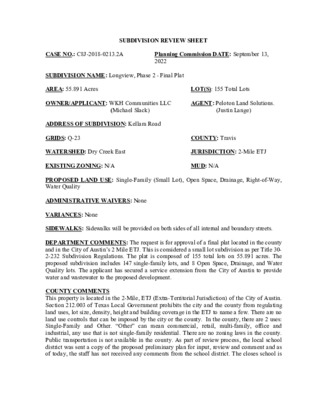
SUBDIVISION REVIEW SHEET CASE NO.: C8J-2018-0213.2A Planning Commission DATE: September 13, 2022 MUD: N/A COUNTY: Travis LOT(S): 155 Total Lots JURISDICTION: 2-Mile ETJ AGENT: Peloton Land Solutions. SUBDIVISION NAME: Longview, Phase 2 - Final Plat AREA: 55.891 Acres OWNER/APPLICANT: WKH Communities LLC (Michael Slack) (Justin Lange) ADDRESS OF SUBDIVISION: Kellam Road GRIDS: Q-23 WATERSHED: Dry Creek East EXISTING ZONING: N/A PROPOSED LAND USE: Single-Family (Small Lot), Open Space, Drainage, Right-of-Way, Water Quality ADMINISTRATIVE WAIVERS: None VARIANCES: None SIDEWALKS: Sidewalks will be provided on both sides of all internal and boundary streets. DEPARTMENT COMMENTS: The request is for approval of a final plat located in the county and in the City of Austin’s 2 Mile ETJ. This is considered a small lot subdivision as per Title 30- 2-232 Subdivision Regulations. The plat is composed of 155 total lots on 55.891 acres. The proposed subdivision includes 147 single-family lots, and 8 Open Space, Drainage, and Water Quality lots. The applicant has secured a service extension from the City of Austin to provide water and wastewater to the proposed development. COUNTY COMMENTS This property is located in the 2-Mile, ETJ (Extra-Territorial Jurisdiction) of the City of Austin. Section 212.003 of Texas Local Government prohibits the city and the county from regulating land uses, lot size, density, height and building coverage in the ETJ to name a few. There are no land use controls that can be imposed by the city or the county. In the county, there are 2 uses: Single-Family and Other. “Other” can mean commercial, retail, multi-family, office and industrial, any use that is not single-family residential. There are no zoning laws in the county. Public transportation is not available in the county. As part of review process, the local school district was sent a copy of the proposed preliminary plan for input, review and comment and as of today, the staff has not received any comments from the school district. The closes school is the Del Valle High School located on Ross Road. The closes fire station is EDS #11 located on FM 812. ISSUES: Staff has not received any inquiries from anyone on this proposed subdivision. STAFF RECOMMENDATION: This final plat is recommended with conditions as it will meet all applicable state, county, and City of Austin Title 30 – Land Development Code requirements once applicant has satisfied all remaining comments identified on the case manager report. (see attached). This plat is subject HB3167. ZONING AND PLATTING COMMISSION ACTION: CASE MANAGER: Jose Luis Arriaga/Sue Welch Email address: joe.arriaga@traviscountytx.gov PHONE: 854-7562 CONSUMER PROTECTION NOTICE FOR HOMEBUYERS: BENCHMARK 2 LEGEND SITE BENCHMARK 1 VICINITY MAP (NOT TO SCALE) IF YOU ARE BUYING A LOT IN THIS SUBDIVISION, YOU SHOULD DETERMINE WHETHER THE SUBDIVISION AND THE LAND AROUND IT ARE INSIDE OR OUTSIDE THE CITY LIMITS. THIS CAN AFFECT THE ENJOYMENT AND VALUE OF YOUR HOME. DEPENDING ON STATE LAW AND OTHER FACTORS, LAND OUTSIDE THE CITY LIMITS MAY BE SUBJECT TO FEWER LOCAL THE CONTROLS GOVERNMENT DEVELOPMENT AND USE OF THE LAND THAN INSIDE THE CITY LIMITS. THE SUBDIVISION'S RESTRICTIVE COVENANTS MAY CREATE PRIVATELY ENFORCEABLE RESTRICTIONS AGAINST INCOMPATIBLE LAND USES WITHIN THE SUBDIVISION, WHETHER IT IS INSIDE OR OUTSIDE THE CITY LIMITS. DEPENDING ON STATE LAW AND OTHER FACTORS, HOWEVER, OUTSIDE THE CITY LIMITS NEITHER PRIVATE NOR GOVERNMENTAL RESTRICTIONS MAY BE AVAILABLE TO (1) RESTRICT EITHER THE NATURE OR EXTENT OF DEVELOPMENT NEAR THE SUBDIVISION, OR (2) PROHIBIT LAND USES NEAR THE SUBDIVISION THAT INCOMPATIBLE WITH A RESIDENTIAL ARE NEIGHBORHOOD. OVER 4214 Medical Parkway, Ste. 300 Austin, TX 78756 512-831-7700 TBPELS Firm Registration No. 10194108 - Austin Office Copyright c 2015 Peloton Land Solutions, Inc. LONGVIEW, PHASE 2 TRAVIS COUNTY, TEXAS JOB #: WLH18001 TECHNICIAN: A. ROMERO SURVEYOR: R. HYSMITH DATE: FEBRUARY 2022 REVISIONS: MARCH, 2022 SHEET OF 6 1 C8J-2018-0213.2A _______ ________________ ____________________________________ ____________________________________ __________________________________________________________________________ _____ ________________ ___ _____ ___ _______ ________________ _______ ___________________________. _______ _______________ _______________________ _______________________ _________________________________ OF T E E G I STER E E X A D S T A S T R P L R A N O O FESS I D SU R V A L N E R Y O 4214 Medical Parkway, Ste. 300 Austin, TX 78756 512-831-7700 TBPELS Firm Registration No. 10194108 - Austin Office Copyright c 2015 Peloton Land Solutions, Inc. LONGVIEW, PHASE 2 TRAVIS COUNTY, TEXAS JOB #: WLH18001 TECHNICIAN: A. ROMERO SURVEYOR: R. HYSMITH DATE: FEBRUARY 2022 REVISIONS: MARCH, 2022 SHEET OF 6 2 C8J-2018-0213.2A 4 1 2 3 4 5 6 7 8 2 2 D A O R O L I 0 S S R A C S O 100' 200' SCALE: 1" = 100' BLOCK 27 21 20 19 18 17 16 15 14 XXX.X 6 7 8 9 10 11 12 13 14 15 BLOCK 29 31 30 29 28 27 26 25 24 23 22 21 _ _ 16 E 1 _ _ S A H _ _ _ _ E W , P _ O . P . R . T . C . T . _ _ _ I V G C . # L N 15 O O D 6 7 8 9 10 11 12 13 14 BLOCK 30 32 31 30 29 28 27 26 25 24 23 22 9 10 11 12 13 16 17 18 19 20 17 18 19 20 21 16 17 18 19 20 21 5 0 0 Y R - C O A 6 BLOCK 26 2 5 Y R - C O A 7 BLOCK 26 500YR-COA S 33°07'46" E 137.46' S 41°52'12" E 86.81' NORTH DRAINAGE EASEMENT "DE" CEF ) 5 F T T C R R O C A T 2 T T W O E D N D . I N , L C . ( 4 0 A 0 H O . P . R . T . C . T . C . # O 1 N S 2 8 0 1 8 A A O R T M 6 A E J O D E R 1 . 6 A 1 2 A O R - C Y 0 0 5 39.70' 40.00' 40.00' 40.00' 40.00' 40.00' 40.00' 40.00' 40.00' 40.00' 40.00' 20.00' S 62°58'40" E 460.20' 14 15 ' 8 4 . 4 1 1 16 ' 1 5 . 4 1 1 17 ' 3 5 . 4 1 1 18 ' 6 5 . 4 1 1 19 20 ' 8 5 . 4 1 1 ' 1 6 . 4 1 1 21 ' 3 6 . 4 1 1 22 BLOCK 26 ' 6 6 . 4 1 1 23 ' 8 6 . 4 1 1 24 10' P.U.E. (TYP.) 40.00' 40.00' 40.00' 40.00' 40.00' 40.00' 40.00' 40.00' 40.00' 40.00' 40.00' 87.95' 110.85' BLOCK 26 44 OPEN SPACE, PUBLIC ACCESS, LANDSCAPE, DRAINAGE 5 0 0 Y R - C O A 198.80' 25 OPEN SPACE, PUBLIC ACCESS, LANDSCAPE, DRAINAGE, WATER QUALITY ' 6 8 . 7 2 3 W ' " 4 2 4 5 ° 6 2 S ' 3 0 . 3 1 2 ' 4 8 . 4 1 1 1 2 L N 62°56'29" W 110.85' L22 C8 15' P.U.E. 5' LANDSCAPE (TYP.) C9 L23 4 2 L L25 C10 ' 2 4 . 4 3 2 W ' " 2 5 3 0 ° 7 2 S ' 9 5 . 4 3 2 W ' " 2 5 3 0 ° 7 2 S ' 2 3 . 4 3 2 ' E " 3 2 4 5 ° 6 2 N C 7 0 2 L ' 0 7 . 4 1 1 ' W " 3 2 4 5 ° 6 2 S E C A R R E T M R A F H S D E W S I C 1 5 ' 1 4 . 4 3 2 ' E " 2 5 3 0 ° 7 2 N C 16 C 1 7 ' 2 0 . 6 3 ' 5 3 . 0 4 ' 5 3 . 0 4 ' 5 3 . 0 4 ' 5 3 . 0 4 ' 9 9 . 6 3 ' 0 1 . 7 3 ' 4 2 . 0 4 ' 7 3 . 0 4 ' 9 3 . 0 4 ' 0 6 . 4 3 2 ' E " 2 5 3 0 ° 7 2 N ' 0 0 . 6 3 C 1 8 C 1 9 ' 0 0 . 6 3 ' 8 9 . 2 4 ' 0 0 . 3 4 ' 2 0 . 4 4 ' 0 0 . 6 3 ' 1 0 . 2 0 2 ' E " 2 5 3 0 ° 7 2 N ' 9 3 . 8 9 ' W " 2 1 4 0 ° 7 2 S 25 ' 1 0 . 9 9 ' W " 0 1 4 0 ° 7 2 S ' 4 3 . 9 9 ' W " 2 3 3 0 ° 7 2 S ' 8 2 . 8 9 ' W " 2 3 3 0 ° 7 2 S ' 0 0 . 0 5 ' 5 3 . 0 4 ' 5 3 . 0 4 ' 5 3 . 0 4 ' 5 3 . 0 4 ' 0 0 . 1 5 ' 1 1 . 1 5 . 0 4 ' 7 3 . 0 4 ' 9 3 . 0 4 ' 0 5 . 0 4 ' 0 0 . 0 5 ' 0 4 . 2 6 2 ' W " 2 1 4 0 ° 7 2 S ' 1 6 . 2 6 2 ' E " 2 3 3 0 ° 7 2 N 13 14 106.99' 15 107.00' 16 107.00' 17 93.01' 13 107.00' 15 107.00' 16 18 92.98' 107.00' 25 107.00' 26 106.99' 17 N62°56'29"W 106.99' ' 0 5 . 0 4 9 1 L L18 C 6 EDNA MAXINE WALK N62°56'29"W 527.96' JOINT USE ACCESS EASEMENT #1 DOC. # ____________________ O.P.R.T.C.T. N62°56'29"W 489.96' W O R ' 0 5 76.08' 20.00' 45.00' 47.74' 47.74' 47.74' 47.75' 45.00' 20.00' 92.98' 6 N62°56'36"W 105.07' 7 8 ' 5 8 . 0 2 1 9 10 ' 6 8 . 0 2 1 11 12 S62°55'48"E 106.99' ' 7 8 . 0 2 1 ' E " 5 1 3 0 ° 7 2 N 22.50' 47.74' 47.72' 22.50' BLOCK 31 47.74' 47.74' N62°55'47"W 235.94' S62°55'47"E 235.94' 47.74' 47.73' 47.75' 47.72' 22.50' 2 N62°56'36"W 105.04' 24 ' 4 5 . 1 2 1 23 ' 3 5 . 1 2 1 22 ' 3 5 . 1 2 1 21 ' 2 5 . 1 2 1 20 ' 2 5 . 1 2 1 19 15' P.U.E. 5' LANDSCAPE (TYP.) S62°55'48"E 107.00' 18 19.00' 20.00' 45.03' 47.67' 47.74' 47.74' 47.75' 45.00' 20.00' 93.01' C 5 C4 L17 L15 6 1 L S62°56'11"E 432.95' W O R ' 5 6 GILWELL DRIVE N62°56'11"W 432.92' JOINT USE ACCESS EASEMENT #2 DOC. # ____________________ O.P.R.T.C.T. 19.01' 20.00' 45.00' 47.74' 47.74' 47.74' 47.75' 44.94' 20.00' BLOCK 43 ' 6 8 . 1 2 1 9 ' 6 8 . 1 2 1 10 ' 5 8 . 1 2 1 11 ' 4 8 . 1 2 1 ' E " 5 1 3 0 ° 7 2 N 12 22.49' 47.74' 47.74' 47.74' 47.72' 22.47' N62°56'40"W 235.90' S62°56'40"E 235.91' 22.51' 47.74' 47.74' 47.74' 47.72' 22.47' 24 23 22 21 20 19 ' 7 7 . 0 2 1 ' E " 8 0 5 0 ° 7 2 N ' 7 7 . 0 2 1 ' W " 8 0 5 0 ° 7 2 S ' 7 7 . 0 2 1 ' E " 8 0 5 0 ° 7 2 N ' 7 7 . 0 2 1 ' W " 0 1 4 0 ° 7 2 S 8 9 11 12 13 10 BLOCK 26 ' E " 2 3 3 0 ° 7 2 N ' 2 4 . 4 1 1 ' 6 4 . 4 1 1 ' W " 3 2 4 5 ° 6 2 S S 62°56'29" E 86.01' ' 6 3 . 4 3 2 ' E " 3 3 3 0 ° 7 2 N H T A P E R U T S A P R E F N N E J I ' 5 6 . 4 3 2 ' E " 3 3 3 0 ° 7 2 N H T A P E R U T S A P R E F N N E J I ' 0 0 . 6 3 ' 0 0 . 0 4 ' 0 0 . 0 4 ' 0 0 . 0 4 ' 0 0 . 0 4 ' 5 3 . 8 3 ' 5 6 . 8 3 ' 0 0 . 0 4 ' 0 0 . 0 4 ' 0 0 . 0 4 ' 0 0 . 0 4 ' 1 0 . 6 3 ' 1 0 . 0 5 ' 0 0 . 0 4 ' 0 0 . 0 4 ' 0 0 . 0 4 ' 0 0 . 0 4 ' 6 3 . 2 5 ' 4 6 . 2 5 ' 0 0 . 0 4 ' 0 0 . 0 4 ' 0 0 . 0 4 ' 0 0 . 0 4 ' 0 0 . 0 5 ' 7 3 . 2 6 2 ' E " 6 0 4 0 ° 7 2 N ' 4 6 . 2 6 2 ' W " 1 3 3 0 ° 7 2 S ' 3 3 . 8 9 ' E " 5 1 3 0 ° 7 2 N ' 5 0 . 9 9 ' E " 0 1 4 0 ° 7 2 N ' 7 3 . 9 9 ' E " 1 3 3 0 ° 7 2 N 25 ' 6 2 . 8 9 ' E " 1 3 3 0 ° 7 2 N 5 105.06' 4 105.05' 3 105.04' 1 6 5 105.02' 4 105.02' 3 105.02' 2 1 S62°56'29"E 105.02' C 3 L14 L12 3 1 L ' 1 0 . 5 1 1 ' E " 1 3 3 0 ° 7 2 N 13 ' 1 0 . 5 1 1 ' E " 1 3 3 0 ° 7 2 N ' 4 8 . 0 2 1 ' E " 5 1 3 0 ° 7 2 N ' 7 8 . 1 2 1 ' E " 5 1 3 0 ° 7 2 N ' 6 7 . 0 2 1 ' W " 5 1 3 0 ° 7 2 S ' 0 0 . 5 1 1 ' E " 1 3 3 0 ° 7 2 N C L S L A 7 X 0 E A T 1 6 A 3 E I 0 C . R S - T 2 . 6 9 I 1 N 9 U O . P . R . T . C . T . C . # T 2 5 7 1 P 1 M O 2 M D O H C W L 3 T E E H S E N L H C T A M I 4 T E E H S E N L H C T A M I 66.96' 20.00' 45.02' 47.67' 47.74' 47.74' 47.75' 44.99' 20.00' S62°56'29"E 480.85' MATTEROD DRIVE N62°56'29"W 480.84' JOINT USE ACCESS EASEMENT #3 DOC. # ____________________ O.P.R.T.C.T. 42.29' 42.29' 42.29' 42.29' 42.29' 42.29' 42.29' 42.29' 45.01' 20.00' 93.00' 6 7 8 9 10 11 12 14 15 16 ' 1 0 . 5 1 1 17 ' 1 0 . 5 1 1 ' 1 0 . 5 1 1 18 ' 1 0 . 5 1 1 19 ' 1 0 . 5 1 1 20 ' 1 0 . 5 1 1 21 22 ' 1 0 . 5 1 1 BLOCK 52 S 62°56'26" E 338.10' 51.29' 51.26' 51.26' 51.26' 51.26' 51.26' 51.26' 42.29' 42.29' 42.29' 42.29' 42.29' 42.29' 42.29' 42.29' 45.00' 51.26' 51.26' 51.26' 51.26' 51.26' 51.26' 55.00' N62°56'28"W 383.33' BLOCK 52 41 ' 0 0 . 5 1 1 40 39 ' 0 0 . 5 1 1 ' 0 0 . 5 1 1 38 37 ' 0 0 . 5 1 1 ' 0 0 . 5 1 1 36 35 ' 0 0 . 5 1 1 34 ' 0 0 . 5 1 1 ' 0 0 . 5 1 1 33 32 ' 9 9 . 4 1 1 31 ' 9 9 . 4 1 1 30 ' 9 9 . 4 1 1 29 ' 0 0 . 5 1 1 ' W " 1 3 3 0 ° 7 2 S ' 0 0 . 0 5 42 23 S62°56'29"E 107.00' 8 9 ' 24 ' 1 0 . 5 1 1 ' E " 1 3 3 0 ° 7 2 N ' 1 0 . 0 3 2 ' W " 2 5 3 0 ° 7 2 S ' 1 0 . 0 3 2 ' W " 2 5 3 0 ° 7 2 S . 2 4 ' 0 0 . 3 4 ' 2 0 . 4 4 ' 0 0 . 0 5 ' 9 9 . 4 1 1 ' W " 1 3 3 0 ° 7 2 S ' 9 9 . 4 1 1 28 E C A R R E T M R A F H S D E W S I C 20 ' 1 0 . 2 0 2 ' W " 2 5 3 0 ° 7 2 S ' 9 9 . 5 3 ' 4 3 . 3 4 ' 4 3 . 3 4 ' 4 3 . 3 4 ' 1 0 . 6 3 S62°56'08"E 107.00' 4 5 107.00' 3 107.00' 2 29 3 3 L 2 3 L 6 ' 0 0 . 5 1 1 46.25' 53.00' ' 0 0 . 5 1 1 28 ' 0 0 . 0 5 ' 4 3 . 3 4 ' 4 3 . 3 4 ' 4 3 . 3 4 ' 0 0 . 0 5 ' 0 0 . 5 1 1 ' E " 2 5 3 0 ° 7 2 N ' 0 0 . 5 1 1 ' E " 2 5 3 0 ° 7 2 N S62°56'29"E 107.00' 27 S62°56'08"E 107.00' 1 7 ' 0 0 . 5 1 1 8 ' 0 0 . 5 1 1 9 ' 0 0 . 5 1 1 10 ' 0 0 . 5 1 1 11 ' 0 0 . 5 1 1 12 ' 0 0 . 5 1 1 13 ' 0 0 . 5 1 1 42.00' 42.00' 42.00' 42.00' 42.00' 42.00' 53.00' 53.00' 53.00' 53.00' 53.00' 53.00' S62°56'29"E 427.26' BLOCK 53 42.00' ' 0 0 . 5 1 1 26 ' 0 0 . 5 1 1 25 27 ' 0 0 . 5 1 1 24 ' 0 0 . 5 1 1 23 ' 0 0 . 5 1 1 22 C11 S 62°56'29" E 652.50' JOINT USE ACCESS EASEMENT #4 DOC. # ____________________ O.P.R.T.C.T. N62°56'29"W 651.90' W O R ' 0 5 93.01' 20.00' 46.25' 42.00' 42.00' 42.00' 42.00' 42.00' 42.00' 42.00' 42.00' 51.29' 51.26' 51.26' 51.26' 51.26' 51.26' 51.26' 51.26' 51.26' 51.26' 51.26' 51.26' 51.26' 54.98' 20.00' 93.01' C 21 C 2 2 93.00' 20.00' 53.00' 53.00' 53.00' 53.00' 53.00' 53.00' 53.00' 23.45' 50.00' 50.00' 50.00' 50.00' 50.00' 50.00' 50.00' 50.00' 50.00' 50.00' 50.00' L9 50.00' 50.00' 50.00' 50.00' 50.00' 50.00' S62°56'29"E 834.42' S62°56'29"E 573.45' AXEL JOHANSON DRIVE S62°56'29"E 300.00' S62°56'29"E 639.44' S62°56'29"E 645.50' 398.78' W O R ' 0 5 32 BLOCK 42 31 30 29 28 27 26 25 24 23 22 32 18 19 20 21 22 5 4 3 2 1 ' 0 0 . 5 1 1 ' E " 1 3 3 0 ° 7 2 N C2 C14 ' 0 0 . 5 1 1 ' E " 1 3 3 0 ° 7 2 N 1 1 L C1 13 N 2 0 ° 0 4 1 1 4 . 2 7 ' ' 2 1 " E 12 6 7 8 9 10 11 12 13 14 15 S62°56'29"E 105.02' 7 8 S62°56'29"E 107.00' 4 2 ' 14 63' ROW 11 5 10 B L O C K 4 9 14 ' 0 0 . 5 1 1 15 16 ' 0 0 . 5 1 1 17 ' 0 0 . 5 1 1 ' 0 0 . 5 1 1 18 ' 0 0 . 5 1 1 19 22 ' 0 0 . 5 1 1 23 ' 0 0 . 5 1 1 24 25 28 29 ' 0 0 . 5 1 1 ' 0 0 . 5 1 1 30 31 ' 0 0 . 5 1 1 27 32 7 L 5 L 455.0' 50.17' 455.0' 50.00' 455.0' 50.00' 455.0' 50.00' 455.0' 50.00' 454.5' 50.00' 454.5' 454.5' 50.00' 50.00' 454.5' 50.00' 454.5' 50.00' 454.0' 50.00' 454.0' 50.00' 454.0' 50.00' 454.0' 50.00' 454.0' 50.00' 454.0' 50.00' 20 ' 0 0 . 5 1 1 21 ' 0 0 . 5 1 1 454.5' 454.5' BLOCK 45 50.00' 50.00' N 62°58'05" W 600.17' N 62°56'29" W 300.00' S 62°56'29" E 242.69' ' 0 0 . 5 1 1 ' E " 1 3 3 0 ° 7 2 N L6 L4 ' 0 0 . 5 1 1 ' E " 1 3 3 0 ° 7 2 N 3 L 26 BLOCK 45 L10 L8 2 L 1 L 500YR-COA S 66°31'52" E 395.98' 500YR-COA SOUTH DRAINAGE EASEMENT "DE" DOC. # 2021262077 O.P.R.T.C.T. F E C FLOODPLAIN EASEMENT PART 3 DOC. # 2021124441 O.P.R.T.C.T. A O R - C 5 0 0 Y ' 7 9 . 7 9 5 ' E " 5 4 3 1 ° 7 2 N MATCHLINE SHEET 3 MATCHLINE SHEET 5 4214 Medical Parkway, Ste. 300 Austin, TX 78756 512-831-7700 TBPELS Firm Registration No. 10194108 - Austin Office Copyright c 2015 Peloton Land Solutions, Inc. LONGVIEW, PHASE 2 TRAVIS COUNTY, TEXAS JOB #: WLH18001 TECHNICIAN: A. ROMERO SURVEYOR: R. HYSMITH DATE: FEBRUARY 2022 REVISIONS: MARCH, 2022 SHEET OF 6 3 C8J-2018-0213.2A BLOCK 45 33 OPEN SPACE, PUBLIC ACCESS, LANDSCAPE, DRAINAGE MATCHLINE SHEET 3 MATCHLINE SHEET 5 MATCHLINE SHEET 3 MATCHLINE SHEET 4 AXEL JOHANSON DRIVE 50.00' 50.00' W O R ' 0 5 34 ' 0 0 . 5 9 ' 0 0 . 5 9 ' W " 1 3 3 0 ° 7 2 S 50.00' 50.00' S62°56'29"E 200.01' 500YR-COA 500YR-COA C L S L A 7 X 0 E A T 1 C . R 6 A S - T 3 2 . 6 E I 9 I 1 N 9 U O . P . R . T . C . T . 0 C . # T 2 7 5 1 P 1 M O 2 M D O H C W L 5 0 0 Y R - C O A C L S L A 7 X 0 E A T 1 6 A 3 E I 0 C . R S - T 2 . 6 9 I 1 N 9 U O . P . R . T . C . T . C . # T 2 7 1 5 P 1 M O 2 M D O H C W L 3 T E E H S E N L H C T A M I 4 T E E H S E N L H C T A M I JOINT USE ACCESS EASEMENT #5 DOC. # ____________________ O.P.R.T.C.T. C12 L26 42.00' 42.00' 42.00' 42.00' 42.00' 42.00' 44.99' 20.00' 91.65' ' 0 0 . 5 1 1 9 ' 0 0 . 5 1 1 10 ' 0 0 . 5 1 1 11 ' 0 0 . 5 1 1 12 ' 0 0 . 5 1 1 13 ' 0 0 . 5 1 1 14 BLOCK 53 42.00' 42.00' 42.00' 42.00' 42.00' 42.00' 42.00' 43.41' 53.00' 53.00' 53.00' S62°56'29"E 427.26' 53.00' 53.00' 56.25' ' 0 0 . 5 1 1 25 26 ' 0 0 . 5 1 1 24 ' 0 0 . 5 1 1 23 ' 0 0 . 5 1 1 22 21 53.00' 53.00' 53.00' 53.00' 53.00' 56.26' 20.00' 79.17' S 62°56'29" E 652.50' W O R ' 0 5 MATTEROD DRIVE N62°56'29"W 651.90' ' 0 0 . 5 1 1 ' E " 2 5 3 0 ° 7 2 N ' 0 0 . 5 1 1 ' E " 2 5 3 0 ° 7 2 N 30 ' ' 0 0 . 0 5 16 15 S62°56'29"E 105.37' 3 3 ' 17 1 0 . 0 3 2 ' W " 1 3 3 0 ° 7 2 S ' 1 0 . 0 3 2 ' W " 1 3 3 0 ° 7 2 S . 3 4 ' 3 3 . 3 4 ' 4 3 . ' 0 0 . 0 5 105.03' 18 104.70' 19 3 4 N62°56'29"W 104.36' 20 ' 9 8 . 5 3 ' 3 3 . 3 4 ' 3 3 . 3 4 ' 4 3 . 3 4 ' 0 2 . 5 2 ' 0 0 . 2 4 ' 0 0 . 2 4 ' 0 5 . 1 4 ' 0 0 . 0 4 ' 0 0 . 0 4 ' 0 0 . 0 4 C 2 3 50' ROW ' 4 6 . 3 5 2 ' E " 1 1 0 3 ° 7 2 N I E V R D S E R C A D E R F L A C24 C30 C29 W O R ' 0 5 W O R ' 0 5 W O R ' 0 5 S62°56'29"E 639.44' AXEL JOHANSON DRIVE S62°56'29"E 645.50' 50.00' 50.00' 50.00' 50.00' 46.71' ' 0 0 . 5 9 ' W " 1 3 3 0 ° 7 2 S BLOCK 45 34 ' 0 0 . 5 9 35 ' 0 0 . 5 9 ' 0 0 . 5 9 36 37 453.5' 50.00' 453.5' 50.00' 453.5' 50.00' 453.5' 50.00' S62°56'29"E 200.01' ' 0 0 . 5 9 ' E " 1 3 3 0 ° 7 2 N 38 453.5' S44°37'45"E 135.83' 0 Y R - C O A 0 5 CEF L27 S 62°56'29" E 115.01' 48 N62°56'29"W 115.01' 47 115.01' 46 115.01' 45 115.01' 44 115.01' 43 115.01' ' 0 0 . 2 4 ' 0 0 . 2 4 ' 0 5 . 1 4 ' 0 0 . 0 4 ' 0 0 . 0 4 ' 0 0 . 0 4 ' 0 0 . 0 4 ' 5 3 . 4 8 ' 5 2 . 5 5 C 2 5 C 2 6 8.20' 42 N62°56'29"W 93.25' 7 2 C C28 41 S33°59'27"E 103.47' 40 C 1 3 S 0 1 ° 0 1 ' 2 N 0 3 ° 5 4 ' 0 8 " W 1 1 7 " E 1 4 9 3 . 8 4 ' . 0 7 ' 8 2 L S 55°22'28" E 86.91' BLOCK 45 33 OPEN SPACE, PUBLIC ACCESS, LANDSCAPE, DRAINAGE MATCHLINE SHEET 3 MATCHLINE SHEET 5 MATCHLINE SHEET 3 MATCHLINE SHEET 4 SOUTH DRAINAGE EASEMENT "DE" DOC. # 2021262077 O.P.R.T.C.T. CEF ' . 2 1 5 2 4 W ' " 1 1 0 3 ° 7 2 S ' 5 3 . 9 9 7 W ' " 1 1 0 3 ° 7 2 S 5 T E E H S E N L H C T A M I 4 T E E H S E N L H C T A M I 721.26' 1 E D G N G C . 1 A G A 0 . 9 G E N D . L N R . L I T 7 S 1 O . P . R . T . C . T . 0 R 2 C . # O I 5 6 1 1 H K D 1 5 O J N 62°46'15" W 1442.52' 9 2 L F C E N 53°27'05" W 215.51' C . L V A O 0 0 E N 5 L L A T , I 3 0 4 C . 8 8 6 8 A 4 5 . 9 E N D I T P & G 2 # C . E 4 S A S U H D E O 0 100' 200' SCALE: 1" = 100' XXX.X 500YR-COA Line Table Line Table Line # Direction Length Line # Direction Length L1 N88° 20' 59"E 108.08' L21 S27° 03' 31"W 50.00' N27° 03' 31"E 37.94' N62° 56' 29"W 33.00' S83° 19' 49"E 58.86' S62° 56' 11"E 33.00' N73° 58' 04"E 49.79' L24 S27° 03' 49"W 65.00' N27° 03' 31"E 128.48' L25 N62° 56' 11"W 33.00' L22 L23 N62° 56' 29"W 54.23' L26 S62° 29' 49"E 50.00' S27° 03' 31"W 115.00' L27 S27° 30' 11"W 13.00' N27° 03' 31"E 115.00' L28 N84° 25' 01"W 55.40' N62° 56' 29"W 20.00' L29 N26° 26' 41"E 54.12' L10 S27° 03' 31"W 115.00' L11 N25° 44' 54"E 50.02' S62° 56' 29"E 15.50' N27° 03' 31"E 50.00' L14 N62° 57' 21"W 24.06' S62° 56' 11"E 72.01' N27° 02' 40"E 65.00' N62° 56' 11"W 71.99' S62° 58' 21"E 15.00' N27° 03' 31"E 50.00' N26° 54' 23"E 37.20' Curve Table Curve Table Curve # Radius Length Delta Chord Bearing Chord Curve # Radius Length Delta Chord Bearing Chord C1 445.00' 17.46' 2°14'55" S67° 03' 16"E 17.46' C21 14.00' 21.99' 89°59'39" N72° 03' 42"E 19.80' 1264.45' 55.05' 2°29'41" S63° 33' 54"E 55.05' 14.00' 21.99' 90°00'21" S17° 56' 18"E 19.80' 14.00' 21.99' 90°00'49" N17° 56' 51"W 19.80' 14.00' 22.10' 90°26'39" N17° 43' 09"W 19.88' 14.00' 21.99' 90°00'18" N72° 03' 40"E 19.80' 25.00' 39.08' 89°33'21" N72° 16' 51"E 35.22' 14.00' 21.99' 89°59'42" N17° 56' 20"W 19.80' 14.00' 12.98' 53°07'48" N00° 56' 16"E 12.52' 14.00' 21.99' 89°59'41" N72° 03' 24"E 19.80' 51.00' 26.34' 29°35'47" N10° 49' 44"W 26.05' 50.00' 48.46' 55°32'04" N00° 51' 39"W 46.59' 51.00' 35.00' 39°19'18" N23° 37' 48"E 34.32' 14.00' 21.99' 89°59'39" S72° 03' 42"W 19.80' 51.00' 35.00' 39°19'18" N62° 57' 07"E 34.32' 14.00' 21.99' 90°00'03" S17° 56' 09"E 19.80' 51.00' 2.79' 3°07'55" S11° 22' 38"E 2.79' 14.00' 21.99' 89°59'57" S72° 03' 51"W 19.80' 14.00' 12.98' 53°07'48" N36° 22' 34"W 12.52' C22 C23 C24 C25 C26 C27 C28 C29 C30 14.00' 21.99' 90°00'21" S17° 56' 18"E 19.80' 14.00' 21.88' 89°33'21" N72° 16' 51"E 19.72' 51.00' 75.17' 84°26'39" N55° 09' 55"W 68.54' 445.15' 23.21' 2°59'17" S64° 26' 09"E 23.21' 14.00' 21.99' 90°00'21" N17° 56' 18"W 19.80' 14.00' 21.99' 89°59'57" N72° 03' 51"E 19.80' 14.00' 21.99' 90°00'03" N17° 56' 09"W 19.80' 14.00' 21.99' 89°59'39" N72° 03' 42"E 19.80' 14.00' 21.99' 90°00'21" N17° 56' 18"W 19.80' 14.00' 21.99' 89°59'39" S72° 03' 42"W 19.80' L2 L3 L4 L5 L6 L7 L8 L9 L12 L13 L15 L16 L17 L18 L19 L20 C2 C3 C4 C5 C6 C7 C8 C9 C10 C11 C12 C13 C14 C15 C16 C17 C18 C19 C20 ” 4214 Medical Parkway, Ste. 300 Austin, TX 78756 512-831-7700 TBPELS Firm Registration No. 10194108 - Austin Office Copyright c 2015 Peloton Land Solutions, Inc. LONGVIEW, PHASE 2 TRAVIS COUNTY, TEXAS JOB #: WLH18001 TECHNICIAN: A. ROMERO SURVEYOR: R. HYSMITH DATE: FEBRUARY 2022 REVISIONS: MARCH, 2022 SHEET OF 6 4 C8J-2018-0213.2A 0 100' 200' SCALE: 1" = 100' MATCHLINE SHEET 3 MATCHLINE SHEET 5 6 BLOCK 45 E 1 _ _ _ _ S A H _ _ _ _ E W , P _ O . P . R . T . C . T . _ _ _ I V G C . # N O L O D ' 7 9 . 7 9 5 ' E " 5 4 3 1 ° 7 2 N F E C E F C F E C F E C F E C SOUTH DRAINAGE EASEMENT "DE" DOC. # 2021262077 O.P.R.T.C.T. N 62°46'15" W 1442.52' Z & A J S 1 O 2 O 6 3 A O L A A C . A M Z A G A N U N R 9 3 R 2 R # 0 1 2 0 O . P . R . T . C . T . 1 0 . 5 N E A B C . O O J E G P N N A D O S J BLOCK 45 33 OPEN SPACE, PUBLIC ACCESS, LANDSCAPE, DRAINAGE MATCHLINE SHEET 3 MATCHLINE SHEET 5 MATCHLINE SHEET 3 MATCHLINE SHEET 4 5 T E E H S E N L H C T A M I 4 T E E H S E N L H C T A M I 721.26' 1 E D G N G C . 1 A G A 0 . 9 G E N D . L N R . L I T 7 S 1 O . P . R . T . C . T . 0 R 2 C . # O I 6 1 5 1 H K D 1 5 O J STREET NAME STREET LENGTH R.O.W. WIDTH PAVEMENT WIDTH CROSS SECTION SIDEWALK CLASSIFICATION DESIGN SPEED STREET TABLE AXEL JOHANSEN DRIVE MATTEROD DRIVE SWEDISH FARM TERRACE EDNA MAXINE WALK ALFRED ACRES DRIVE GILWELL DRIVE 1,619.4' 1,263.1' 920.0' 614.0' 347.3' 556.9' 50' 50' 63' 50' 50' 65' TOTAL LENGTH OF PROPOSED ROADWAY - 5,320.7' 28' F-F 28' F-F 28' F-F 28' F-F 28' F-F 38' F-F 2 LANE, C & G 2 LANE, C & G 2 LANE, C & G 2 LANE, C & G 2 LANE, C & G 4' 4' 6' 4' 4' LOCAL LOCAL LOCAL LOCAL LOCAL 30 M.P.H. 30 M.P.H. 30 M.P.H. 30 M.P.H. 30 M.P.H. 2 LANE C & G 10' & 6' RESIDENTIAL COLLECTOR 35 M.P.H. D L I 5 2 L L E C . I N A A T G 6 1 9 A 0 . 4 D A O P S I M I V O . P . R . T . C . T . 2 C . # R 1 B 1 0 5 7 D R O 1 E A D L A R N F I 721.26' D Y N O A O A N O 6 6 8 T 7 C . 5 A Z M M R 0 A A O E 1 N E R N M 7 0 7 2 # O . P . R . T . C . T . 5 . 0 1 I I O I D L C E A D C . O D R I A R Z A N A M 4214 Medical Parkway, Ste. 300 Austin, TX 78756 512-831-7700 TBPELS Firm Registration No. 10194108 - Austin Office Copyright c 2015 Peloton Land Solutions, Inc. LONGVIEW, PHASE 2 TRAVIS COUNTY, TEXAS JOB #: WLH18001 TECHNICIAN: A. ROMERO SURVEYOR: R. HYSMITH DATE: FEBRUARY 2022 REVISIONS: MARCH, 2022 SHEET OF 6 5 C8J-2018-0213.2A XXX.X DRAINAGE EASEMENT "DE" KEY MAP (NOT TO SCALE) NORTH DRAINAGE EASEMENT "DE" SOUTH DRAINAGE EASEMENT "DE" DOC. #2021262077 O.P.R.T.C.T. 4214 Medical Parkway, Ste. 300 Austin, TX 78756 512-831-7700 TBPELS Firm Registration No. 10194108 - Austin Office Copyright c 2015 Peloton Land Solutions, Inc. LONGVIEW, PHASE 2 TRAVIS COUNTY, TEXAS JOB #: WLH18001 TECHNICIAN: A. ROMERO SURVEYOR: R. HYSMITH DATE: FEBRUARY 2022 REVISIONS: MARCH, 2022 SHEET OF 6 6 C8J-2018-0213.2A CITY OF AUSTIN – TRAVIS COUNTY – SINGLE SUBDIVISION OFFICE SUBDIVISION APPLICATION – MASTER COMMENT REPORT CASE NUMBER: REVISION #: CASE MANAGER: C8J-2018-0213.2A UPDATE: 00 Joe Arriaga PHONE #: U0 512-854-7562 PROJECT NAME: LOCATION: Longview Phase 2 6001-1/2 KELLAM RD SUBMITTAL DATE: August 15, 2022 REPORT DUE DATE: September 6, 2022 FINAL REPORT DATE: September 7, 2022 STAFF REPORT: 1 DAY HAS BEEN ADDED TO THE UPDATE DEADLINE This report includes all staff comments received to date concerning your most recent subdivision application submittal. The comments may include requirements, recommendations, or information. The requirements in this report must be addressed by an updated submittal. The subdivision application will be approved when all requirements from each review discipline have been addressed. However, until this happens, your application is considered disapproved. Additional comments may be generated as a result of information or design changes provided in your update. If you have any questions, problems, concerns, or if you require additional information about this report, please do not hesitate to contact your case manager at the phone number listed above or by writing to the City of Austin, Development Services Department, P.O. Box 1088, Austin, Texas 78767. UPDATE DEADLINE (LDC 30-2-56; 30-2-82): It is the responsibility of the applicant or their agent to update this subdivision application. The final update to clear all comments must be submitted by the update deadline, which is November 15, 2022. Otherwise, the application will automatically be denied. If this date falls on a weekend or City of Austin holiday, the next City of Austin workday will be the deadline. EXTENSION OF UPDATE DEADLINE (LDC 30-1-119): You may request an extension to the update deadline by submitting a written justification to your case manager on or before the update deadline. Extensions may be granted for good cause at the Director’s discretion. UPDATE SUBMITTALS: A formal update submittal is required. You must make an appointment with the Intake Staff (974- 2689) to submit the update. Please bring a copy of this report with you upon submittal to Intake. Please submit 1 copies of the plans and 1 copies of a letter that address each comment for distribution to the following reviewers. Clearly label information or packets with the reviewer’s name if intended for a specific reviewer. No distribution is required for the Planner 1. Updates may be submitted between the hours of 8:30 am and 4:00 pm. Updates submitted after 3 pm may be processed on the following business day. Please note: if Austin Water rejects a plan on Update 2, a fee is due at or before resubmittal. Please contact Intake for the fee amount. REVIEWERS: Planner 1 : Sophia Briones Site Plan Plumbing : Juan Beltran Travis Co. Subdivision Review - Sue Welch for Joe Arriaga - 512-854-7562 1. 2. 3. 4. 5. 6. 7. 8. 9. 10. 11. Please continue to work with the final Joint Access Easement documents for final review by City legal and County staff. Approved and recorded easements, properly annotated on the final plat (or recorded and annotated concurrent with the recordation of the final plat subject to approval of Travis County Subdivision Reviewer) will be required prior to making the final plat file complete. Please clarify if the lots with JUE are restricted from access to the adjoining streets. 30-1-113 Provide the signed Travis County Subdivision Agreements as requested – on 8/12/2022: Per Engineer of Record Justin Lange, P.E., these signed documents will be provided with the formal submittal for technical review. This will be required to have a separate agenda request for Court approval. 30-1-113 Prior to recordation of this plat, provide documentation that approval have been received for the required traffic mitigations in the agreement with Travis County per agreement with Court. Provide a status of these requirements. Prior to recordation of the final plat – provide the receipt for that parkland fees have been paid. Add a note to the plat that fee-in-lieu have been paid for 147 units. 30-1-113 Add Longview Phase 1 recording information – Phase 1 must be out of alternative fiscal and recorded, prior to recordation of this plat. 30-1-113 Could not locate a benchmark on the plat. 30-1-113 Prior to final plat recordation, the applicant must provide a copy of the Homeowner’s Document/Declaration of Covenants and Restrictions. Show instrument number on plat. (Required for SF-4A small lot subdivisions) 30-2-232/ 30-1-113 Verify approval from TCFMO is for the plat, not the preliminary plan. 30-1-113 Provide current tax certificates showing all taxes have been paid for 2021. 30-1-113 Please remove note #40 – isn’t this a repeat of note #14? Approval of the plat expires on the 90th day after the approval date if the single office has not certified that the applicant has posted fiscal security. 30-2-84 Electric Review - Andrea Katz - Andrea.Katz@austinenergy.com EL 1. Please remove landscape easement that overlaps PUE or separate into two separate easements 911 Addressing Review - Janny Phung - janny.phung@austintexas.gov AD1: This plat review is rejected for the following: AD2: Please remove all forms of punctuation after abbreviating street types or directional including streets in the vicinity map AD3: Please update label to read as follows S SH 130 the directional S must be included in the vicinity map AD3: Please update label to read as follows E SH 71 the directional E must be included in the vicinity map AD4: SWEDISH FARMS TER is the correct street name for this project NOTE: Punctuation or diacritical marks cause confusion for first responders NOTE: E SH 71 is incorrectly labeled as HIGHWAY 71 NOTE: S SH 130 is incorrectly labeled as I 130 NOTE: If you are changing the name of SWEDISH FARMS TER then a street name change must be requested The standards applied to all new street names in Travis County can be found at this link: http://www.austintexas.gov/sites/default/files/files/Information_Technology/911Addressing/Street_ Name_Standards.pdf NOTE: After this plat has been Recorded, please submit your request for addresses by using the link below. https://subdivisionaddressrequest.azurewebsites.net/ Addressing Management Services has up to 15 working days to complete the assignment of addresses for a recorded plat. §30-2-155 End of Comment Flood Plain Review - Zach Kretsch - 512-974-3363 DATE REVIEWED: 9/1/2022 UPDATE # U0 General notes: As mentioned in the CC comment document and expired plats, a project assessment will be required prior to subdivision construction plans to review modifications proposed within the floodplain. The floodplain has NOT been reviewed extensively with the preliminary plans based on the latest comments from the preliminary plan. See the comments below. Notice to applicant: Applicant must remedy all compliance issues without creating additional compliance issues with the LDC and/or Criteria manuals. A response that fails to correct an issue, or which creates other issues does not comply with the LDC and is insufficient to address the comments. The comments provided describe an issue that must be remedied in order for the application to be approved. Any specific examples are provided as a courtesy and are not intended as an exhaustive list, especially as the site may be updated to have additional compliance issues. Contact this reviewer if you have any questions zach.kretsch@austintexas.gov. FP1: The site, as shown on the plan provided, is not in compliance with the following sections of the Land Development Code. Please correct your application to be in compliance with Code. 30-4-33 – Floodplain Maps, Delineation, and Depiction 30-4-152 – Dedication of Easements and Rights-of-Way FP2: The applicant is required to contain the limits of the FEMA and City of Austin Regulatory floodplain within a drainage easement per LDC 25-7-152 and/or LDC 30-4-152. Please provide documentation demonstrating this or provide requisite easement. Comment to remain open until easement has been recorded. FP3: Tt appears from property profile that there is FEMA A zone on your lots which is not shown. Please delineate the FEMA Floodplain on plat. If property profile is incorrect, please provide exhibit showing that current FEMA A zone is contained to proposed Drainage Easement. If FEMA current Floodplain is NOT contained to drainage easement, please follow instructions in LDC 25- 7-33E/30-4-33E. See the screenshots below. PARD / Planning & Design Review - Justin Stewart - 512-974-9475 Update: 0 PR 1: Parkland dedication is required per Section 30-2-213 of the City Code. COA is nearest park provider and we will require parkland. Please contact this reviewer as soon as possible to discuss which land is needed. You should have completed a Parkland Early Determination letter prior to submittal. Thank you. Water Quality Review - Kyle Virr - 512-974-2538 Release of this application does not constitute a verification of all data, information, and calculations supplied by the applicant. The engineer of record is solely responsible for the completeness, accuracy, and adequacy of his/her submittal, whether or not the application is reviewed for code compliance by city engineers. WQ1: Provide a water quality plan using the assumed impervious cover as described in Land Development Code Section 25-8-64. Include all items specified in the Subdivision Application Packet, Page 17. Please demonstrate that runoff from all new impervious cover will be routed to the proposed water quality pond. WQ2: ECM 1.6.8 states, “On-site control of the two-year storm is achieved when the developed- conditions peak runoff rate leaving the site for a given drainage area is less than or equal to the existing-conditions runoff rate. The flow rates can be considered equal if the developed rate is no more than one-half (0.5) cfs greater than the existing rate or if the developed rate is no more than one-half (0.5) percent greater than the existing rate and there are no existing erosion problems downstream of the site” (LDC 25-7-61). Please provide compliance. WQ3: Please provide Certification of Compliance 25-1-83 – Applications Related to a Closed Municipal Solid Waste Landfill. The certification following website: http://austintexas.gov/sites/default/files/files/Planning/Applications_Forms/Landfill_Verification_Fo rm.pdf form can be found at the Wetlands Biologist Review - Hank Marley - hank.marley@austintexas.gov Travis Co. Transportation Review - Teresa Calkins - 512-854-7569 No comments at this time. Travis County Engineering Review Teresa Calkins, P.E. September 7, 2022 Transportation: TR 1. Title 30 Section § 30-3-161 and by reference the Transportation Criteria Manual. Your JUAE documents have been forwarded to Travis County legal staff for review. Please also provide directly to Annette Bogusch at the City of Austin, copying me. Copies of recorded JUAE documents, or executed documents ready for recordation with the final plat, will be required prior to approval of the final plat at Commissioners Court. TR 2. Title 30 Section § 30-3-161 Fiscal Surety Please confirm that the developer proposes to utilize alternative fiscal for this final plat, as Phase 1 is still under alternative fiscal. It would be necessary for the Phase 1 Final Plat to be either accepted and recorded, or full fiscal posted for Phase 1, in order for Phase 2 to be allowed to post full fiscal. Drainage: DR 1. Title 30 Section § 30-4-31 and by reference the Drainage Criteria Manual. Your memorandum is noted explaining that the 500 year storm precipitation data (DCM?) was utilized as a stand-in for Atlas 14 prior to the release of Atlas 14 precipitation data (i.e., a rainfall depth of 13.5 inches was utilized compared to an Atlas-14 100yr depth of 12.80 inches. Please clarify as well that Atlas 14 precipitation data has been utilized for the design of the storm drainage system for Longview Phase 2, as well as for the staging in detention ponds, where utilized, for events smaller than the 500 year event referenced in your memo. DR 2. Note: Please clear the comments provided by the City of Austin Floodplain Reviewer addressing floodplain delineation and drainage easements related to this final plat. DR 3. Title 30 Section § 30-2-132 - EASEMENTS AND ALLEYS Please confirm any easements that encumber the area of the final plat that will be vacated prior to the recordation of the final plat. If any easements are proposed to be vacated concurrently with the recordation of the final plat, please provide the completed vacation documents ready for recordation. Otherwise, show and label any separate instrument easements that exist within or adjacent to the boundaries of the final plat. Site Plan Plumbing - Juan Beltran - 512-972-2095 Pursuant to compliance with Sections 307.1, 609.6, and 721.1 of the 2021 Uniform Plumbing Code, add a plat note that conveys the following: Each Lot within this subdivision shall have separate sewer taps, separate water meters, and their respective private water and sewer service lines shall be positioned or located in a manner that will not cross lot lines. END OF REPORT A CITY O TIN S U F D . M R A L L E K H I G H W A Y 7 1 E . D. K R E E R O C R R A V A N S S D. O R R D. S R S O R W O M R A L L E K PEA R C E LN. i t i b h x E p a M n o i t a c o L - 2 e s a h P \ s c o D \ l i i i \ v C \ 2 e s a h P w e v g n o L _ 1 0 0 8 1 H L W B O J \ t \ n e m p o e v e d l d n a l \ c d n i t s u a - v r s \ \ M P 7 0 : 4 1 2 0 2 6 4 : i e m T e t a D t o P l LOCATION MAP EXHIBIT LONGVIEW PHASE 2 AUSTIN, TRAVIS COUNTY, TEXAS NOT TO SCALE