05 C14-2022-0087 - 8701 and 8627 N MoPac; District 10.pdf — original pdf
Backup
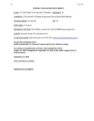
ZONING CHANGE REVIEW SHEET CASE: C14-2022-0087 (8701 and 8627 N MoPac) DISTRICT: 10 ADDRESS: 8701 and 8627 N Mopac Expressway Service Road North Bound ZONING FROM: LO and LR TO: CS SITE AREA: 8.36 acres PROPERTY OWNER: 8701 MoPac Atrium LLC and US REIF Eurus Austin LLC AGENT: Drenner Group, PC (Amanda Swor) CASE MANAGER: Sherri Sirwaitis (512-974-3057, sherri.sirwaitis@austintexas.gov) STAFF RECOMMEDATION: Staff recommends CS, General Commercial Services District, zoning. PLANNING COMMISSION ACTION / RECOMMENDATION: August 23, 2022: Postponed to September 13, 2022 at the staff's request (12-0, S. Praxis-absent). September 13, 2022 CITY COUNCIL ACTION: ORDINANCE NUMBER: 1 of 135 C14-2022-0087 ISSUES: 2 During the Burnet Road, Anderson Lane and the North Shoal Creek Area neighborhood planning process, the long-range planning staff did not add the –NP combining district to the end of the zoning string for the properties in the planning area. Therefore, the rezoning request does not require the “NP” annotation. CASE MANAGER COMMENTS: The property in question is developed with office buildings (The Atrium Office Centre and Chancellor Center). There is an industrial use/emulsion plant (Ergon Asphalt & Emulsions, Inc.) and a landscaping supply use (Legacy Turf and Greens) to the north. The lots to the south are developed with office buildings. To the east, there is a railway and office and industrial uses. To the west is the North Mopac Expressway. The applicant is requesting CS, General Commercial Services District, zoning to bring the exiting office structures into compliance with site development regulations in the Land Development Code (Please see Applicant’s Request Letter-Exhibit C). The staff recommends CS zoning for this property because it meets the intent of the ‘CS’ district as it fronts onto the frontage road to a major arterial roadway, North Mopac Expressway (Loop 1). The proposed zoning would be consistent with existing zoning patterns in this area because there is commercial (CS) zoning to the north, office and commercial (LO, LR, GR) zoning to the south and west and office and industrial uses (zoned LI) to the east of this site. The CS zoning would allow for a fair and reasonable use of the site because it would make it possible for the applicant to bring the existing office complex into compliance. In addition, the proposed zoning would permit additional services to be developed in this area along a Level 4 roadway. The property is located within the North Burnet/Gateway Station Regional Center as designated by the Imagine Austin Comprehensive Plan. The applicant agrees with the staff ‘s recommendation. BASIS OF RECOMMENDATION: 1. The proposed zoning should be consistent with the purpose statement of the district sought. General Commercial Services district is intended predominately for commercial and industrial activities of a service nature having operating characteristics or traffic service requirements generally incompatible with residential environments. Neighborhood Plan district denotes a tract located within the boundaries of an adopted Neighborhood Plan. The property under consideration is accessible from major traffic ways as it fronts onto the feeder street North Mopac Expressway. 2 of 135 C14-2022-0087 3 2. The proposed zoning should promote consistency and orderly planning. The proposed CS zoning would be compatible with existing zoning patterns in this area because there is CS zoning to the north, LO and LR zoning to the south, LI zoning to the east and a major arterial roadway/highway to the west of this site. The proposed CS zoning is consistent with the Commerce character district designation adopted for this area in the North Shoal Creek Neighborhood Plan. 3. The proposed zoning should allow for a reasonable use of the property. The General Commercial Services zoning district would allow for a fair and reasonable use of the site because it would provide the applicant with additional permitted uses to allow for the expansion of office and commercial services on a site that fronts onto a major arterial Level 4 roadway/highway. EXISTING ZONING AND LAND USES: ZONING LAND USES Site North South East LO, LR CS-NP LO, LR LI West ROW, GR Office (The Atrium Office Centre, Chancellor Center) Industrial (Ergon Asphalt & Emulsions, Inc.) Office (Mopac Centre), Automotive Services (NTB) Railway (Union Pacific Railroad), Office/Warehouse, Office (TDCJ Government Building), Industrial (All-Tex, Facets of Austin) MoPac Expressway, Office (Hyridge Place), Multifamily (Wood Harbour) NEIGHBORHOOD PLANNING AREA: Burnet Road, Anderson Lane and the North Shoal Creek Neighborhood Planning Area TIA: Deferred to the time of Site Plan WATERSHED: Shoal Creek SCHOOLS: Austin I.S.D. NEIGHBORHOOD ORGANIZATIONS: Austin Independent School District Austin Lost and Found Pets Austin Neighborhoods Council Friends of Austin Neighborhoods Friends of North Shoal Creek Homeless Neighborhood Association Neighborhood Empowerment Foundation 3 of 135 C14-2022-0087 4 North Austin Civic Association North Austin Neighborhood Alliance North Shoal Creek Neighborhood Association North Shoal Creek Neighborhood Plan Contact Team NW Austin Neighbors SELTEXAS Shoal Creek Conservancy Sierra Club, Austin Regional Group TNR BCP – Travis County Natural Resources AREA CASE HISTORIES: NUMBER C14-2020-0013 (8803 N Mopac) REQUEST LI to CS COMMISSION 5/12/20: Approved staff's recommendation of CS zoning by consent (13-0); P. Seeger-1st, G. Anderson-2nd. C14-2014-0156 (MoPac Rezoning: 8611 LO to GR 11/12/14: Approved staff rec. of GR-CO zoning on consent (8-0, L. Varghese-absent); R. Hattfield- 1st, B. Roark-2nd. C14-2010-0164 (8610 North Mopac Rezoning) LR-CO to GR 11/16/10: Approved GR-CO zoning on consent, with the following additional conditions offered by the applicant: No Pawn Shop Services use and a public restrictive covenant to state that business will be closed during the hours of 10:00 p.m. to 6:00 a.m. (6-0, Banks-absent); P. Seeger-1st, D. Tiemann-2nd. 7/30/07: Approved staff rec. for CS-MU-CO with conditions (8-0) CS to CS-MU C14-2007-0085 (8888 Tallwood Drive) C14-91-0013 (Horizon Savings Motorbank) SF-3 to LO and LR 4/02/91: Denied LR-CO & LO- CO zoning CITY COUNCIL 6/11/20: Approved CS district zoning, with additional condition agreed to by the neighborhood and the applicant is to prohibit Adult Oriented Businesses (11-0); all 3 readings 11/ 20/14: Approved GR-CO zoning, with additional conditions agreed to by the applicant and the neighborhood, on consent on all 3 readings (7-0) 12/11/14: Approved GR-CO zoning on consent on 2nd/3rd readings (7-0) 12/09/10: Approved GR-CO zoning on consent on all 3 readings (7-0); B. Spelman-1st, M. Martinez-2nd. 8/09/07: Approved CS-MU-CO zoning, with CO to prohibit Adult Oriented Businesses and a 2,000 vehicle trip limit per day 5/23/91: Approved LR-CO for Tract 1 and LO-CO zoning for Tract 2 w/ following conditions: 1) prohibit Food Sales, General Retail Sales (Convenience), Restaurant (Limited), Restaurant (Drive-In/Fast Food), and Service 4 of 135 C14-2022-0087 5 Station uses on Tract 1; 2) No vehicular access from Tract 2 to Camelia Lane; 3) Maintain the existing 40 ft vegetative buffer along the western property line of Tract 2; 4) Maintain a 25 ft vegetative buffer along the northern property line of Tract 2; 5) Structures on Tract 2 shall not exceed two stories or 35 ft in height RELATED CASES: C8S-82-146 – Subdivision Case C14r-82-016 – Previous Zoning Cases EXISTING STREET CHARACTERISTICS: N Mopac Expressway SVRD NB OTHER STAFF COMMENTS: Comprehensive Planning Name ASMP Classification ASMP Required ROW Existing ROW Existing Pavement Level 4 310’ 330’ 290’ Sidewalks Bike Route Capital Metro (within ¼ mile) Yes N/A No Project Name and Proposed Use: 8701 and 8627 N MOPAC EXPY SERVICE RD., C14- 2022-0087. 6.39 acres from LO, LR to CS. Office to Office/Commercial. FLUM: Commerce. July 7, 2022 Yes Y Imagine Austin Decision Guidelines Compact and Connected Measures Imagine Austin Growth Concept Map: Located close to, within or adjacent to an Imagine Austin Activity Center, Imagine Austin Activity Corridor, or Imagine Austin Job Center as identified on the Growth Concept Map. Name(s) of Activity Center/Activity Corridor/Job Center: North Burnet/Gateway Station Regional Center Mobility and Public Transit: Located within 0.25 miles of public transit stop and/or light rail station. Y Mobility and Bike/Ped Access: Adjoins a public sidewalk, shared path, and/or bike lane. Y Connectivity, Good and Services, Employment: Provides or is located within 0.50 miles to goods and services, and/or employment center. Connectivity and Food Access: Provides or is located within 0.50 miles of a grocery store/farmers market. Connectivity and Education: Is located within 0.50 miles from a public school or university. Connectivity and Healthy Living: Provides or is located within 0.50 miles from a recreational area, park or walking trail. 5 of 135 C14-2022-0087 6 Connectivity and Health: Provides or is located within 0.50 miles of health facility (ex: hospital, urgent care, doctor’s office, drugstore clinic, specialized outpatient care.) Housing Affordability: Provides a minimum of 10% of units for workforce housing (80% MFI or less) and/or fee in lieu for affordable housing. Housing Choice: Expands the number of units and housing choice that suits a variety of household sizes, incomes, and lifestyle needs of a diverse population (ex: apartments, triplex, granny flat, live/work units, cottage homes, and townhomes) in support of Imagine Austin and the Strategic Housing Blueprint. Mixed Use: Provides mixed use development (minimum 10% residential and 10% non-residential floor area). Culture and Creative Economy: Provides or is located within 0.50 miles of a cultural resource (ex: library, theater, museum, cultural center). 3 Total Number of “Yes’s” Imagine Austin Priority Program Bonus Features (Extra Points) Y Small Area Plan Policies: Supports applicable Small Area Plans, including the Future Land Use Map, goals, objectives, actions and text. List three small area plan policies that relate to this project. Name of Small Area Plan: North Shoal Creek NP Culture and Historic Preservation: Preserves or enhances a historically and/or culturally significant site. Culture and Creative Economy: Expands Austin’s creative economy (ex: live music venue, art studio, film, digital, theater.) Workforce Development, the Economy and Education: Expands the economic base by creating permanent jobs, especially an industry that is currently not represented in particular area or that promotes a new technology. Workforce Development, the Economy and Education: Promotes educational opportunities or workforce development training. 4 Total Number of “Yes’s” from Up Top and Under Bonus Features Applicable Small Area Plan Policies: Land Use Policies for Mopac Frontage Road (p. 32) MF P1 Encourage a balance of offices and services, discourage residential. MF P2 Allow building heights of four to six-stories and vehicular-oriented site design. MF P3 Integrate beautification of landscape areas and plant trees to provide shade along walk and bike paths. COMMERCE DISTRICT FEATURES (p. 50) The following features were identified as characteristics that should be typical to the Commerce District: • Auto-oriented, region- serving commercial with frontage road access • Building heights up to six stories where not adjacent to Residential Core • Heights should step down to be compatible with adjacent residences • Placement of windows should respect the privacy of neighboring residences • Landscaping and fences to buffer adjacent residences • Adequate parking, visible from street • Multi-lane drive-thru facilities Environmental The site is not located over the Edwards Aquifer Recharge Zone. The site is located in the Shoal Creek Watershed of the Colorado River Basin, which is classified as an Urban Watershed by Chapter 25-8 of the City's Land Development Code. It is in the Desired Development Zone. Zoning district impervious cover limits apply in the Urban Watershed classification. According to floodplain maps there is no floodplain within or adjacent to the project 6 of 135 C14-2022-0087 location. 7 Standard landscaping and tree protection will be required in accordance with LDC 25-2 and 25-8 for all development and/or redevelopment. At this time, site specific information is unavailable regarding vegetation, areas of steep slope, or other environmental features such as bluffs, springs, canyon rimrock, caves, sinkholes, and wetlands. This site is required to provide on-site water quality controls (or payment in lieu of) for all development and/or redevelopment when 8,000 sq. ft. cumulative is exceeded, and on site control for the two-year storm. At this time, no information has been provided as to whether this property has any preexisting approvals that preempt current water quality or Code requirements. Fire No comments. Parks and Recreation Site Plan There are currently no parkland requirements for uses other than residential and hotel. Given that the application is for existing professional office, there would not be parkland dedication requirements or parkland impacts unless redeveloped with a new site plan or subdivision. General A site plan will be required for any new development other than single-family, two-family or duplex residential. Any new development is subject to the design standards in Subchapter E of the Land Development Code. Additional comments will be made when the site plan is submitted. Any new development which is located 540 ft. or less from property in an SF-5 or more restrictive zoning district will be subject to compatibility development regulations. Along the western property line, the height of a structure more than 300 feet but not more than 540 feet from SF-3 property is limited to 60 feet plus one foot for each four feet of distance in excess of 300 feet from the SF-3 property. Existing Conditions This tract is already developed and the proposed zoning change is within the footprint of an existing development. 7 of 135 C14-2022-0087 8 Neighborhood Planning Area This site is located in the North Shoal Creek Neighborhood Planning Area. Please see the City’s Neighborhood Plans and Resources webpage for a copy of the recommended design guidelines. Scenic Roadway Sign District Regulations FYI: Site is required to comply with Scenic Roadway sign regulations in 25-10-124. Transportation There is a proposed Urban Trail adjacent to this site, along the Union Pacific Railroad.” The easement required is a minimum of 20 ft as this allows for a 12 ft trail (minimum trail width per the urban trails plan) and room for maintenance activity. This is the same for Tier I and Tier II trails. Assessment of required transportation mitigation, including the potential dedication of right of way and easements and participation in roadway and other multi-modal improvements, will occur at the time of site plan application. A traffic impact analysis shall be required at the time of site plan if triggered per LDC 25-6-113. Water Utility The landowner intends to serve the site with City of Austin water and wastewater utilities. The landowner, at own expense, will be responsible for providing any water and wastewater utility improvements, offsite main extensions, utility relocations and or abandonments required by the land use. The water and wastewater utility plan must be reviewed and approved by Austin Water for compliance with City criteria and suitability for operation and maintenance. Based on current public infrastructure configurations, it appears that service extension requests (SER) will be required to provide service to this lot. For more information pertaining to the Service Extension Request process and submittal requirements contact the Austin Water SER team at ser@austintexas.gov. The landowner must pay the City inspection fee with the utility construction. The landowner must pay the tap and impact fee once the landowner makes an application for a City of Austin water and wastewater utility tap permit. INDEX OF EXHIBITS TO FOLLOW A: Zoning Map B. Aerial Map C. Applicant’s Request Letter 8 of 135 L R T E L K C U S Y E N O H SF-3 LO ( ( ( ( ( ( ( ( SF-3 ( ( ( ( ( ( ( ( ( SF-3 ( R K D IC W O L WIL ( ( ( ( ( ( ( SF-3 ( APTS. CS CS B U S I N E S S P A R K D R OFFICE BLDGS. ( ( ( ( ( ( ( ( SF-3 ( ( ( ( ( ( SF-3 ( ( ( ( ( ( L R T A E L A Z A 2007-0085 CS-MU-CO TALLW ( O O D D R ( ( ( SF-3 ( LO GR SP- 03-0407C ( ( ( H Y R I D G E D R ( ( N L A I L E M A C ( ( ( ( ( ( ( ( SF-3 ( LO GR LO-CO C14-2010-0164 GR-CO CIM A S E R E N A B S D R V S Y P X E C A P O M N P M A R H C R A E S E O R T B N C A P O M N B N D R V S Y P X E C A P O M N ( C14H-2021-0165 SF-3-H ( ( ( ( ( ( ( ( ( ( ( ( ( PUD APTS. ( ( S E R E N A W ( O O D S C T ( ( C L A B U R N D R PUD CP78-63 MF-2 PUD B E N T T R E E R D 78-114 LO SP-95-0157C 79-73 OFFICE PARK SPC-88-0189A 75-232 OFFICE PARK P M A K R C E T O S B T C S PA O N M LR C14-2015-0056 ± SUBJECT TRACT ! ! ! ! ! ! PENDING CASE ZONING BOUNDARY P M A S R S A P Y K B C E T C S A P O N M 77-105 LI 78-24 78-222 M O P A C S B T O R E S E A R C H S B R A M P P M A B R H N C R A E S E O R B T N C A P O M P-NP T N A C VA NBG-NP C14-2008-0182 85-244 VACANT R E S E A R R C E S E H N A R C B T R E U S E NIT A R C E D T O M H B L V O P A D S C R V R A M P D N B H B O R L V E S E A D N B R C H N B R A M P R E S E A R C R E S E A R C H B L V D S B H B L V D S V R D S B B Y S P X C E A P O N M P M A R B S C A P O M N O T H C R A E S E R C E B Y N P X A P O N M ! ! ! ! ! ! ! ! ! ! ! ! ! ! ! ! ! ! LR LI 75-107 ! ! ! ! ! ! ! ! ! ! CS C14-2020-0013 NPA-2020-0031.01 EMULSION PLANT ! ! ! ! ! ! ! ! ! ! 84-147 ! ! ! ! ! ! ! ! ! ! 75-092 C14R-82-016RC ! ! LI ! ! ! ! ! ! ! ! ! ! ! ! ! ! LO 88-005 ! ! ! ! ! ! ! ! ! ! ! 83-36 R84-110 LR ! ! ! ! C14R-87-131 R87-131 84-147 ! ! ! ! C14-2014-0192 GR-CO ! ! R83-62RC ! ! 75-65 ! ! ! ! ! ! ! ! ! ! GR R E S T. ! ! ! ! P83-36 ! ! ! GR-CO C14-2014-0156 ! 78-222 SP-02-0140C TEXAS AIR CONTROL BOARD RADIAN CORP. COMMERCIAL WAREHOUSE PARK COMMERCIAL OFFICE PARK PLUMBING SUPPLY CO. SP-01-0490C = = SF-3 = ( > > > MF-2 > ( > > = M O S S R = SF-3 O C K D R = ( ( ( = ( SP-85-014 72-26 ( ( ( OFFICE BLDG. LO ( ( ( ( R Y D A W L MIL ( ( SF-2 ( ( ( ( ( E CIR ( ( ( G RID N W A D ( ( ( ( ( ( SF-2 ( ( ( ( ( SF-2 ( ( ( ( ( SF-3 NP-2016-0031 ( ( ( ( ( ( ( ( ( ( ( B E N B R O ( ( O K D R ( ( ( ( ( SF-2 ( ( ( ( ( ( ( ( ( ( ( ( ( ( ( ( SF-2 ( ( ( ( ( ( ( ( ( R W D VIE E L A D ( ( ( SF-2 ( ( ( R E D N O T S G A L F SF-2 D V L B K E E R C L A O H S APTS. MF-3 APTS. CROSSCREEK DR APTS. ( ( ( MF-3 APTS. APTS. ( SF-2 ( ( ( PARKING CS LO OFFICE ( ZONING ZONING CASE#: C14-2022-0087 This product is for informational purposes and may not have been prepared for or be suitable for legal, engineering, or surveying purposes. It does not represent an on-the-ground survey and represents only the approximate relative location of property boundaries. 1 " = 400 ' This product has been produced by the Housing and Planning Department for the sole purpose of geographic reference. No warranty is made by the City of Austin regarding specific accuracy or Created: 8/18/2022 9 of 135 ( CS-MU-CO ( ( ( ( SF-3 N L A I L E M A C ( SF-3 ( LO ( ( ( GR B S D R V S Y P X E C A P O M N SP-03-0407C LI 75-107 B Y S P X C E A P O N M B Y N P X C E A P O N M ! ! ! ! ! ! ! ! ! ! ! ! ! ! ! ! ! ! ! ! ! ! ! ! ! ! ! ! ! ! ! ! ! C14-2020-0013 NPA-2020-0031.01 CS EMULSION PLANT ! ! ! ! ! ! ! ! ! ! 84-147 ! ! ! ! ! ! ! ! ! ! 75-092 C14R-82-016RC ! ! C14-2022-0087 LR LO J31 88-005 ! ! ! ! ! ! ! ! ! ! ! ! SF-3 LO GR C14-2010-0164 GR-CO LO ± P M A R H C R A E S E B D N R V S Y P X ! ! ! ! ! ! R84-110 ! ! C14R-87-131 LR ! ! ! ! ! ! C14-2014-0192 GR-CO ! ! R83-62RC 75-65 ! ! 83-36 GR R E S T. R87-131 84-147 ! ! ! ! ! ! ! ! ! ! ! ! ! ! ! P83-36 ! ! ! ! GR-CO C14-2014-0156 ! O R B T C N A P O N M C E A P O N M LI 78-222 TEXAS AIR CONTROL BOARD PLUMBING LI SUPPLY CO. SP-01-0490C D V L K B E E R L C A O H S LO MF-3 8701 and 8627 N MoPac SUBJECT TRACT ZONING BOUNDARY ! ! ! ! ! ! PENDING CASE CREEK BUFFER ZONING CASE#: LOCATION: SUBJECT AREA: GRID: MANAGER: C14-2022-0087 8627 & 8701 N Mopac Expy SVRD NB 8.36 Acres J31 Sherri Sirwatis 1 " = 200 ' This product has been produced by the Housing and Planning Department for the sole purpose of geographic reference. No warranty is made by the City of Austin regarding specific accuracy or completeness. Created: 8/18/2022 by: MeeksS 10 of 135 Amanda Swor aswor@drennergroup.com 512-807-2904 Ms. Rosie Truelove Housing and Planning Department City of Austin 1000 E 11th Street Austin, TX 78702 June 14, 2022 Via Electronic Delivery Re: 8701 and 8627 N MoPac – Zoning application package for the approximately 8.36-acre property located at 8701 and 8627 N MoPac Expressway Service Road NB in Austin, Travis County, Texas (the “Property”) Dear Ms. Truelove: As representatives of the owner of the Property, we respectfully submit the enclosed zoning application package. The project is titled 8701 and 8627 N MoPac and is approximately 8.36 acres of land, located on the east side of the northbound MoPac Service Road NB between Steck Avenue and Research Boulevard. The Property is in the full purpose jurisdiction of the City of Austin. This application accompanies a restrictive covenant termination application titled the same, 8701 and 8627 N MoPac which is approximately 8.54 acres. The Property is currently zoned LO-NP (Limited Office – Neighborhood Plan) and LR-NP (Neighborhood Commercial – Neighborhood Plan). The requested rezoning is from LO-NP and LR-NP to a CS-NP (General Commercial Services – Neighborhood Plan). Currently, the Property is developed with professional office use. The purpose of the rezoning is to bring the building into conformance with site development regulations. The Property is within the North Shoal Creek Neighborhood Planning Area, adopted August 23, 2018. The North Shoal Creek Neighborhood Plan was adopted with a future land use map designation of Commerce, which is consistent with the zoning request. Attached is a memo from Maureen Meredith on May 9, 2022, confirming that a plan amendment application is not required. A Commerce designation allows for NO, LO, LR, GO, GR, CS, CS-1, CH, W/LO, P, AG, PUD, and PDA zoning districts; accordingly, our proposed CS-NP zoning aligns with this future land use map designation. The Traffic Impact Analysis ("TIA") is not required, per the attached TIA determination waiver dated April 28, 2022, and executed by Justin Good. 200 Lee Barton Drive, Suite 100 | Austin, Texas 78704 | 512-807-2900 | www.drennergroup.com 11 of 135 Amanda Swor aswor@drennergroup.com 512-807-2904 Please let me know if you or your team members require additional information or have any questions. Thank you for your time and attention to this project. Very Truly Yours, Amanda Swor cc: Joi Harden, Housing and Planning Department (via electronic delivery) Jerry Rusthoven, Housing and Planning Department (via electronic delivery) 200 Lee Barton Drive, Suite 100 | Austin, Texas 78704 | 512-807-2900 | www.drennergroup.com 12 of 135 Memorandum To: From: Intake Division Maureen Meredith, Senior Planner Housing and Planning Dept. Phone: (512) 974-2695 Email: Maureen.meredith@austintexas.gov June 14, 2022 8701 & 8627 N. Mopac Exwy Date: Subject: The above property is located within the North Shoal Creek neighborhood planning area that has a City Council approved neighborhood plan and future land use/character district map. The applicant proposes to change the zoning from LO and LR to CS for an office use. The current character district on the property: Commerce. Proposed change with rezoning: Commerce. No plan amendment application is required, see chart on next page. Maureen FLUM Map Zoning Map 1 13 of 135