13 C14-2022-0052 - E 12th - Fuentes; District 1.pdf — original pdf
Backup
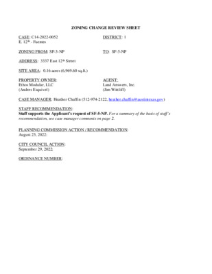
ZONING CHANGE REVIEW SHEET DISTRICT: 1 TO: SF-5-NP CASE: C14-2022-0052 E. 12th - Fuentes ZONING FROM: SF-3-NP ADDRESS: 3337 East 12th Street SITE AREA: 0.16 acres (6,969.60 sq.ft.) PROPERTY OWNER: Ethos Modular, LLC (Andres Esquivel) CASE MANAGER: Heather Chaffin (512-974-2122, heather.chaffin@austintexas.gov) STAFF RECOMMENDATION: Staff supports the Applicant’s request of SF-5-NP. For a summary of the basis of staff’s recommendation, see case manager comments on page 2. AGENT: Land Answers, Inc. (Jim Wittliff) PLANNING COMMISSION ACTION / RECOMMENDATION: August 23, 2022: CITY COUNCIL ACTION: September 29, 2022: ORDINANCE NUMBER: C14-2022-0052 2 ISSUES: No issues at this time. The requested rezoning would allow the property owner to build 2 residential units on the property without being limited by the maximum building square footage of City Accessory Dwelling Unit (ADU) regulations. CASE MANAGER COMMENTS: The subject property is located at the southwest corner of East 12th Street and Greenwood Avenue, approximately 770 feet east of Airport Boulevard. The SF-3-NP zoned lot is currently developed with one single family residence. Properties to the west, south and east are also zoned SF-3-NP and developed with single family residential land uses. Further west, closer to the intersection with Airport Boulevard are properties zoned LR-MU-NP, CS-MU-NP and CS-1-NP. These properties are developed with a mix of land uses, including religious assembly, automotive repair services, liquor sales, professional office and cocktail lounge. Across East 12th Street to the north is Evergreen Cemetery, zoned P- Public. Also across East 12th Street, to the northeast, is another residential neighborhood zoned SF-3-NP. Please see Exhibits A and B- Zoning Map and Aerial Exhibit. Staff supports the rezoning request. While SF-3-NP zoning allows a single family house and an ADU, the ADU is limited to a maximum of 1,100 square feet. The lot is larger than the standard 5,750 square foot lot, but is not large enough to permit duplex residential land use (7,000 square feet). Redeveloping this oversized residential lot to allow two residences would allow a reasonable increase in development intensity and provide an additional housing unit. The property’s location at the intersection of East 12th and Greenwood Avenue, a residential collector street, is also appropriate. BASIS FOR RECOMMENDATION 1. 2. 3. The proposed zoning should be consistent with the purpose statement of the district sought. Zoning should allow for reasonable use of the property. Zoning changes should promote compatibility with adjacent and nearby uses and should not result in detrimental impacts to the neighborhood character. The proposed zoning should promote consistency and orderly planning. 4. EXISTING ZONING AND LAND USES: ZONING Site North South East West LAND USES SF-3-NP P, SF-3-NP SF-3-NP SF-3-NP SF-3-NP, LR-MU-NP, CS- MU-NP, CS-1-MU-NP Single family residential Cemetery, Single family residential Single family residential Single family residential Single family residential, Religious assembly, Automotive repair services, Professional office, Liquor sales, Cocktail lounge NEIGHBORHOOD PLANNING AREA: East MLK Combined (MLK) TIA: N/A WATERSHED: Tannehill Branch C14-2022-0052 3 Austin Lost and Found Pets Del Valle Community Coalition Friends of Austin Neighborhoods Neighborhood Empowerment Foundation Preservation Austin SELTexas NEIGHBORHOOD ORGANIZATIONS: Austin Independent School District Austin Neighborhoods Council East Austin Conservancy Homeless Neighborhood Association Neighbors United for Progress Residents of E 12th St Sierra Club, Austin Regional Group East MLK Combined Neighborhood Plan Contact Team AREA CASE HISTORIES: There are no recent rezonings in the area. ADDITIONAL STAFF COMMENTS: Comprehensive Planning Yes Y Imagine Austin Decision Guidelines Compact and Connected Measures Imagine Austin Growth Concept Map: Located close to, within or adjacent to an Imagine Austin Activity Center, Imagine Austin Activity Corridor, or Imagine Austin Job Center as identified on the Growth Concept Map. Name(s) of Activity Center/Activity Corridor/Job Center: 0.15 Miles from Airport Blvd Activity Corridor Y Mobility and Public Transit: Located within 0.25 miles of public transit stop and/or light rail station. Y Mobility and Bike/Ped Access: Adjoins a public sidewalk, shared path, and/or bike lane. Y Connectivity, Good and Services, Employment: Provides or is located within 0.50 miles to goods and services, and/or employment center. Connectivity and Food Access: Provides or is located within 0.50 miles of a grocery store/farmers market. Connectivity and Education: Is located within 0.50 miles from a public school or university. Y Connectivity and Healthy Living: Provides or is located within 0.50 miles from a recreational area, park and/or walking trail. Y Connectivity and Health: Provides or is located within 0.50 miles of health facility (ex: hospital, urgent care, doctor’s office, drugstore clinic, specialized outpatient care.) Housing Affordability: Provides a minimum of 10% of units for workforce housing (80% MFI or less) and/or fee in lieu for affordable house. Y Housing Choice: Expands the number of units and housing choice that suits a variety of household sizes, incomes, and lifestyle needs of a diverse population (ex: apartments, triplex, granny flat, live/work units, cottage homes, and townhomes) in support of Imagine Austin and the Strategic Housing Blueprint. Mixed Use: Provides mixed use development (minimum 10% residential and 10% non- residential floor area). Culture and Creative Economy: Provides or is located within 0.50 miles of a cultural resource (ex: library, theater, museum, cultural center). 7 Total Number of “Yes’s” 4 C14-2022-0052 Y Imagine Austin Priority Program Bonus Features (Extra Points) Small Area Plan Policies: Supports applicable Small Area Plans, including the Future Land Use Map, goals, objectives, actions and text. List three small area plan policies that relate to this project. Name of Small Area Plan: E MLK Combined Neighborhood Plan Culture and Historic Preservation: Preserves or enhances a historically and/or culturally significant site. Culture and Creative Economy: Expands Austin’s creative economy (ex: live music venue, art studio, film, digital, theater.) Workforce Development, the Economy and Education: Expands the economic base by creating permanent jobs, especially an industry that is currently not represented in particular area or that promotes a new technology. Workforce Development, the Economy and Education: Promotes educational opportunities or workforce development training. 8 Total Number of “Yes’s” From Top and Under Bonus Features Applicable E MLK Combined Small Area Plan Policies: Goal Two - Promote a mix of land uses that respect and enhance the existing neighborhood and address compatibility between residential, commercial, and industrial uses. (p 44) Goal Five - Provide housing that helps maintain the social and economic diversity of residents. (p 45) Environmental 1. The site is not located over the Edwards Aquifer Recharge Zone. The site is located in the Tannehill Branch Creek Watershed of the Colorado River Basin, which is classified as an Urban Watershed by Chapter 25-8 of the City's Land Development Code. 2. Zoning district impervious cover limits apply in the Urban Watershed classification. 3. According to floodplain maps there is no floodplain within or adjacent to the project location. 4. Standard landscaping and tree protection will be required in accordance with LDC 25-2 and 25-8 for all development and/or redevelopment. 5. At this time, site specific information is unavailable regarding vegetation, areas of steep slope, or other environmental features such as bluffs, springs, canyon rimrock, caves, sinkholes, and wetlands. 6. This site is required to provide on-site water quality controls (or payment in lieu of) for all development and/or redevelopment when 8,000 s.f. cumulative is exceeded, and on site control for the two-year storm. Site Plan SP 1. Site plans will be required for any new development other than single-family, two-family or duplex residential. SP 2. Any new development is subject to Subchapter E. Design Standards and Mixed Use. Additional comments will be made when the site plan is submitted. SP 3. This tract is already developed and the proposed zoning change is a footprint within the existing development. The applicant is responsible for requesting relocation and demolition permits once the site plan is approved. The City Historic Preservation Officer will review all proposed building demolitions and relocations prior to site plan approval. If a building meets city historic criteria, the Historic Landmark Commission may initiate a historic zoning case on the property. SP 4. The site is located within Austin-Bergstrom Overlay Controlled Compatible Land Use Area. No use will be allow that create electrical interference with navigational signals or radio communications C14-2022-0052 5 between airport and aircraft, make it difficult for pilots to distinguish between the airport lights and others, result in glare in the eyes of pilots using the airport, impair visibility in the vicinity of the airport, create bird strike hazards or otherwise in any way endanger or interfere with the landing, taking off, or maneuvering of aircraft intending to use the Austin-Bergstrom Airport. Height limitations and incompatible uses with each Airport Overlay zone are established in the Airport Overlay Ordinance. Airport Hazard Zoning Committee review may be required prior to Planning Commission Hearing. Parks & Recreation PR1: Parkland dedication will be required for the new residential units proposed by this development, single family with SF-5-NP zoning, at the time of subdivision or site plan, per City Code § 25-1-601. The requirement may be met with fees in-lieu, as determined using the criteria in City Code Title 25, Article 14, as amended. Any fees in-lieu shall be used toward park investments in the form of land acquisition and/or park amenities within the surrounding area, per the Parkland Dedication Operating Procedures § 14.3.11 and City Code § 25-1-607 (B)(1) & (2). If the applicant wishes to discuss parkland dedication requirements in advance of site plan or subdivision applications, please contact this reviewer: thomas.rowlinson@austintexas.gov. At the applicant’s request, PARD can provide an early determination of whether fees in-lieu of land will be allowed. Water Utility AW1. The landowner intends to serve the site with City of Austin water and wastewater utilities. The landowner, at own expense, will be responsible for providing any water and wastewater utility improvements, offsite main extensions, utility relocations and or abandonments required by the land use. The water and wastewater utility plan must be reviewed and approved by Austin Water for compliance with City criteria and suitability for operation and maintenance. Depending on the development plans submitted, water and or wastewater service extension requests may be required. All water and wastewater construction must be inspected by the City of Austin. The landowner must pay the City inspection fee with the utility construction. The landowner must pay the tap and impact fee once the landowner makes an application for a City of Austin water and wastewater utility tap permit. INDEX OF EXHIBITS TO FOLLOW A: Zoning Map B. Aerial Exhibit ( ( ( ( ( T I L L E R Y S T ( ( 7 2 - 2 7 5 GR-MU-NP C P 7 4 - 4 5 R E T A I L - C O N V E N I E N C E E 1 8 T H S T ( ( ( ( ( L O ( V I N ( G O ( ( O D D SF-3-NP = ( ( ( E 1 7 T H S T ( ( ( R ( ( SF-3-NP ( ( ( SF-3-NP L O R E T O D R ( ( ( ( ( ( ( SF-3-NP ( ( ( ( ( E 1 7 T H S T ( ( ( ( SF-3-NP ( ( ( SF-3-NP ( ( ( ( ( ( ( ( E 1 6 T H S T C 1 4 P - 7 5 - 0 5 7 ( P 8 3 - 3 9 ( ( ( SF-3-NP ( ( 8 4 - 4 7 2 R C C H U R C H SF-3-NP ( ( ( E 1 4 T H H A L F S T ( ( ( ( SF-3-NP ( ( ( ( ( ( ( E 1 4 T H S T ( ( ( ( ( ( ( ( ( LR-MU-NP 8 5 - 3 0 1 S P 8 5 - 1 0 3 ( ( ( ( M C K I N L E Y A V E ( ( SF-3-NP ( ( ( ( ( SF-3-NP ( ( ( E 1 3 T H S T ( ( ( 7 3 - 1 4 5 7 9 - 2 7 1 CS-MU-CO-NP ( ( ( ( ( 9 2 - 0 0 0 7 ( 6 7 - 1 7 CS-1-CO-NP P R O D U C E ( CS-NP CS-MU-V-CO-NP C14-2009-0106 CS-CO-NP S P 9 2 - 1 3 1 C ( ( ( ( ( M H L O U N G E C14-01-0150 APARTMENTS MF-3-NP ( ( ( ( ( ( ( ( ( H A R V E Y S T ( ( SF-3-NP ( ( ( SF-3-NP ( ( ( ( ( ( ( SP-03-0412C MF-3-NP ( R E S T \ H O M E ( 7 7 - 7 1 = ( ( SF-3-NP ( 7 3 - 2 2 5 = E 1 7 T H S T ( ( ( C H U R C H SF-6-CO-NP C14-2016-0025 SF-3-NP ( ( ( ( ( ( ( SF-3-NP EXHIBIT A ( ( ( ( E 1 6 T H S T ( ( ( ( ( ( P E R E Z S T ( ( ( ( SF-3-NP ( ( ( SF-3-NP ( ( ( ( ( ( ( C O M M E R C E S T ( = D E L O N E Y S T ( ( ( ( ( ( ( ( ( ( ( ( ( ( ( ( ( ( ( = ( ( C H U R C H ( ( ( ( ( ( ( ( ( ( 7 3 - 2 2 2 ( C14-02-0142.003 SF-3-NP ( ( ( E M F R A N K L I N A V E ( ( ( ( ( ( ( ( ( ( ( ( ( ( ( ( ( ( ( ( ( ( ( ( ( ( ( ( ( ( G R E E N W O O D A V E ( ( ( ( ( ( ( ( ( ( ( ( ( ( ( ( ( ( ( ( CEMETERY P-NP U N D E V ( LR-MU-NP 52-547 ( ( ( R I D G E D R ( ( ( ( C A R S A L E S ( CS-1-MU-NP 64-008 I A R P O Q L I U O R T B L V D 2 2 0 - 1 8 A U T O P A I N T S E R V I C E R S T O R E S C14-02-0142.003 ( ( CS-NP P80-88 64-93 CS-MU-NP ( ( ( ( ( T E C ( SF-3-NP ! ! ( ! ( !! ! ! ( ( ( C14-02-0142.003 ( ( ( E E B R SF-3-NP ( ( L O V D ( ( ( ( ( ( ( G R E E N W O O D A V E ( ( ( ( ( ( ( ( ( ( ( ( E 1 2 T H S T ( S A R A B E T H W A Y ( ( I E V A N L K N A R F M E ( ( ( SF-3-NP ( ( ( ( ( G R A N T S T ( ( ( ( ( ( ( ( CHURCH SP88-0210D SF-3-NP ( C H U R C H ( ( ( ( ( ( ( ( ( ( ( ( SF-3-NP ( ( ( ( ( PE N N SY LVA N I A AV E = = ( = = ( ( P-NP SF-6-NP 3 4 - 9 6 A U T O R E P . G A R A G E S P - 9 9 - 0 2 7 7 C R Z 8 7 - 1 6 R E S T . R E S T . SERV. STATION CONV. STR. C A R \ W A S H P A W N \ S H O P SP-06-0208C CS-NP SP-02-0360C SP-89-0245C F A S T \ F O O D DRIVE THR U BANK RZ86-66 SP91-132C CS-MU-CO-NP S P 9 1 - 0 0 0 2 C S 8 5 - 2 1 5 C14-02-0142.003 SF-6-NP ( ( LR-MU-NP 87-012 90-061 BEAUTY SHOP ( SHOP ( MH ( ( 80-205 ( ( ( ( ( ( ( ( ( ( ( T R S E T N U G SF-3-NP SF-3-NP ABBATE CIR MF-3-NP R D Y O R E N Y A W CS-MU-NP SP-03-0019C MF-3-NP CS-1-MU-CO-NP 72 -9 1 FAST FOOD SP88-366C 7 5 -1 2 7 ZONING ZONING CASE#: C14-2022-0052 64-037 SP-00-2253C CS-MU-NP TREATMENT\CENTER SP88-0165BS REST HOME CS-MU-V-NP C14-2009-0106 P 8 0 - 4 0 S P - 9 8 - 0 2 3 9 C 01-0150 SP-88-165BS T R E A T M E N T \ C E N T E R CS-MU-NP C14-2009-0106 7 2 - 2 5 4 O A K S P R I N G S D R P-NP MF-3-NP 02-0127.SH SP-02-0341C.SH P-NP LIBRARY T Y S R E L TIL ± SUBJECT TRACT ! ! ! ! ! ! PENDING CASE ZONING BOUNDARY This product is for informational purposes and may not have been prepared for or be suitable for legal, engineering, or surveying purposes. It does not represent an on-the-ground survey and represents only the approximate relative location of property boundaries. 1 " = 400 ' This product has been produced by the Housing and Planning Department for the sole purpose of geographic reference. No warranty is made by the City of Austin regarding specific accuracy or Created: 4/19/2022 CEMETERY P-NP ( ( ( ( EXHIBIT B ( ( ( SF-3-NP ( ( ( ( ( ( ( ( ( ( SF-3-NP ( ( ( ( ( G R E E N W O O D A V E ( ( ( ( ( ( ( ( ( E 1 2 T H S T ( ( ( ( ( S A R A B E T H W A Y ( SF-3-NP CHURCH SF-3-NP U N D E V ( 52-547 LR-MU-NP ( ( ( R I D G ( E D R ( ( ( C A R S A L E S ( CS-NP MF-3-NP CS-1-MU-NP 64-008 A U T O P A I N T ! ! C14-2022-0052 ! ( L23 !! ( ( ! ! ( ( ( C14-02-0142.003 ( ( ( T ( E C L O V ( ( ( D E E B R ( SF-3-NP ( ( ( G R E E N W O O D ( ( ( ( ( A V E ( ( A I R P O CS-MU-NP C14-02-0142.003 ( ( 2 2 0 - 1 8 R T B L V D CS-NP C14-01-0150 P80-88 64-93 ( ( ( ( ( ( SF-3-NP ( C H U R C H ( ( ( ( ( ( ( PE NN SY LVA N I A AV E ( ( ( ( ( SF-6-NP 3 4 - 9 6 CS-MU-NP LR-MU-NP SF-6-NP MF-3-NP CS-MU-NP ± 1 " = 200 ' SUBJECT TRACT ZONING BOUNDARY ! ! ! ! ! ! PENDING CASE CREEK BUFFER E 12th-Fuentes ZONING CASE#: LOCATION: SUBJECT AREA: GRID: MANAGER: C14-2022-0052 3337 E 12th Street 0.16 Acres L23 Heather Chaffin This product has been produced by the Housing and Planning Department for the sole purpose of geographic reference. No warranty is made by the City of Austin regarding specific accuracy or completeness. Created: 7/26/2022 by: MeeksS