B-13 C8-2022-0112 - Velocity Preliminary Plan; District 2.pdf — original pdf
Backup
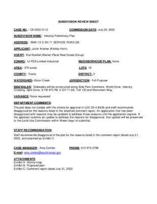
SUBDIVISION REVIEW SHEET CASE NO.: C8-2022-0112 COMMISSION DATE: July 26, 2022 SUBDIVISION NAME: Velocity Preliminary Plan ADDRESS: 3848 1/2 E SH 71 SERVICE ROAD EB APPLICANT: Justin Kramer (Kimley-Horn) AGENT: Karl Koebel (Market Place Real Estate Group) ZONING: LI-PDA Limited Industrial NEIGHBORHOOD PLAN: None AREA: 270 acres LOTS: 19 COUNTY: Travis DISTRICT: 2 WATERSHED: Onion Creek JURISDICTION: Full Purpose SIDEWALKS: Sidewalks will be constructed along Side Park Commons, World Drive, Velocity Crossing, Sprit Drive, S FM 973 Rd, E SH 71 EB, Toll 130 and Monument Way. VARIANCE: None requested DEPARTMENT COMMENTS: The plat does not comply with the criteria for approval in LDC 25-4-84(B) and staff recommends disapproval for the reasons listed in the attached comment report. An application that has been disapproved with reasons may be updated to address those reasons until the application expires. If the applicant submits an update to address the reasons for disapproval, that update will be presented to the Land Use Commission within fifteen days of submittal. STAFF RECOMMENDATION: Staff recommends disapproval of the plat for the reasons listed in the comment report dated July 21, 2022, and attached as Exhibit C. CASE MANAGER: Amy Combs PHONE: 512-974-2786 E-mail: amy.combs@austintexas.gov ATTACHMENTS Exhibit A: Vicinity map Exhibit B: Proposed plan Exhibit C: Comment report dated July 21, 2022 Exhibit A: Vicinity Map VELOCITY PRELIMINARY PLAN SOUTHWEST CORNER OF SH-71 AND SH-130 AUSTIN, TEXAS C8-2020-0141 VELOCITY PRELIMINARY PLAN SHEET INDEX SHEET NO. DESCRIPTION 1 2 3 4 5 6 7 8 9 10 COVER SHEET GENERAL NOTES OVERALL PRELIMINARY PLAN PRELIMINARY PLAN (SHEET 1 OF 6) PRELIMINARY PLAN (SHEET 2 OF 6) PRELIMINARY PLAN (SHEET 3 OF 6) PRELIMINARY PLAN (SHEET 4 OF 6) PRELIMINARY PLAN (SHEET 5 OF 6) PRELIMINARY PLAN (SHEET 6 OF 6) STREET CROSS-SECTIONS H W Y-71 F M-973 PROJECT LOCATION 0 3 X-1 T VICINITY MAP SCALE: 1" = 2,000' NORTH COA GRID: P15, P16 JUNE 2022 LEGAL DESCRIPTION: BEING 270.93 ACRES OF LAND, LOCATED IN THE SANTIAGO DEL VALLE LEAGUE ABSTRACT NUMBER 24, TRAVIS COUNTY, TEXAS, AND BEING A PORTION OF THAT CERTAIN 385.684 ACRE TRACT, CONVEYED TO SH 71-130 HOLDINGS, LP., IN DOCUMENT NUMBER 2014189945 OFFICIAL PUBLIC RECORDS OF TRAVIS COUNTY, TEXAS., AND ALL OF THAT CERTAIN 4.886 ACRE TRACT, CONVEYED TO SH 71-30 HOLDINGS, LP, IN DOCUMENT NUMBER 2014189949, OFFICIAL PUBLIC RECORDS OF TRAVIS COUNTY, TEXAS. OWNER/DEVELOPER MARK BULMASH VC HOLDINGS QOZ, LP 1601 RIO GRANDE, SUITE 300 AUSTIN, TEXAS 78701 TEL: (512) 494-4224 SURVEYOR JOHN GREGORY MOSIER, RPLS, PG KIMLEY-HORN AND ASSOCIATES 601 NW LOOP 410, SUITE 250 SAN ANTONIO, TEXAS 78216 TEL: (210) 321-3402 ENGINEER JUSTIN J, KRAMER, P.E. #122309 KIMLEY-HORN AND ASSOCIATES, INC, 10814 JOLLYVILLE ROAD AVALLON IV, SUITE 200 AUSTIN, TEXAS 78759 TEL: (512) 418-1771 STATE OF TEXAS REGISTRATION NO. F-928 BENCHMARKS BENCHMARKS: TBM #1 TBM #3 "(" SET ON HEADWALL LOCATED 107.93' FROM THE NORTHERLY CORNER OF LOT 3, BLOCK "A", ELEVATION =452.68 FEET (AS SHOWN) "(" SET ON HEADWALL LOCATED 1,107.52'' FROM THE NORTHEASTERLY CORNER OF LOT 3, BLOCK "A", ELEVATION =439.44 FEET (AS SHOWN) PRELIMINARY SUBDIVISION APPROVAL SHEET _____ OF _____ 1 26 FILE NUMBER _______________ APPLICATION DATE _______________ C8-2020-0141 10/14/2020 APPROVED BY LAND USE COMMISSION ON _______________ EXPIRATION DATE LDC 25-4-62 _______________ CASE MANAGER: AMY COMBS, FOR: _____________________________________________ DENISE LUCAS, DIRECTOR, DEVELOPMENT SERVICES DEPARTMENT I Y T C O L E V I N T S U A F O Y T C I S A X E T , Y T N U O C S V A R T I Final plats must be recorded by the Project Expiration Date. Subsequent Site Plans which do not comply with the Code current at the time of filing, and require Building Permits or notice of construction (if a building permit is not required), must also be approved prior to the Project Expiration Date. C8-2020-0141 © T E E H S R E V O C N A L P Y R A N M L E R P I I 1 GENERAL NOTES: CONSTRUCTION. 1. THIS SUBDIVISION IS LOCATED WITHIN CITY OF AUSTIN, FULL PURPOSE JURISDICTION. 2. WATER AND WASTEWATER SERVICE FOR VELOCITY CROSSING WILL BE PROVIDED BY THE CITY OF AUSTIN. 3. THE WATER, RECLAIMED, AND WASTEWATER UTILITY SYSTEM SERVING THIS SUBDIVISION MUST BE IN ACCORDANCE WITH THE CITY OF AUSTIN UTILITY DESIGN CRITERIA. THE WATER, RECLAIMED, AND WASTEWATER UTILITY PLAN MUST BE REVIEWED AND APPROVED BY AUSTIN WATER. ALL WATER, RECLAIMED, AND WASTEWATER CONSTRUCTION MUST BE INSPECTED BY THE CITY OF AUSTIN. THE LANDOWNER MUST PAY THE CITY INSPECTION FEE WITH THE UTILITY 4. PRIOR TO CONSTRUCTION, DRAINAGE PLANS WILL BE SUBMITTED TO THE CITY OF AUSTIN AND TRAVIS COUNTY. 5. ALL STREETS, DRIVEWAYS, SIDEWALKS, WATER, WASTEWATER, AND STORM SEWER LINES SHALL BE CONSTRUCTED IN COMPLIANCE WITH THE CITY OF AUSTIN AND TRAVIS COUNTY STANDARDS. 6. ELECTRIC SERVICE WILL BE PROVIDED BY AUSTIN ENERGY. THE CITY OF AUSTIN. 7. NO OBJECTS, INCLUDING BUT NOT LIMITED TO, BUILDINGS, FENCES, OR LANDSCAPING SHALL BE ALLOWED IN A DRAINAGE EASEMENT EXCEPT AS APPROVED BY 8. PROPERTY OWNER AND/OR HIS/HER ASSIGNS SHALL PROVIDE FOR ACCESS TO THE DRAINAGE EASEMENT AS MAY BE NECESSARY AND SHALL NOT PROHIBIT ACCESS BY THE CITY OF AUSTIN FOR INSPECTION OR MAINTENANCE OF SAID EASEMENT. 9. ALL DRAINAGE EASEMENTS ON PRIVATE PROPERTY SHALL BE MAINTAINED BY THE OWNER AND/OR HIS/HER ASSIGNS . 10. CONDITIONAL PARTICIPATION IN THE REGIONAL STORMWATER MANAGEMENT PROGRAM WAS GRANTED FOR THIS PRELIMINARY PLAN THROUGH PAYMENT ON _________ (DATE) BY THE CITY OF AUSTIN WATERSHED PROTECTION DEPARTMENT, OFFICE OF THE DIRECTOR. THE RSMP CASE NUMBER FOR THIS PROJECT IS _______________. REFER TO RSMP APPROVAL LETTER FOR CONDITIONS OF PARTICIPATION. FORMAL AGREEMENTS MUST BE EXECUTED FOR FUTURE DEVELOPMENTS WITHIN THIS PRELIMINARY PLAN AND PAYMENTS MADE FOR PARTICIPATION AT THE TIME OF DEVELOPMENT. 11. PUBLIC SIDEWALKS, BUILT TO CITY OF AUSTIN STANDARDS, ARE REQUIRED ALONG SKY PARK COMMONS, WORLD DRIVE, VELOCITY CROSSING, SPIRIT DRIVE, S FM 973 RD, SH 71 EB, TOLL 130, MOMENTUM WAY AND ALL IDENTIFIED JOINT USE ACCESS EASEMENTS AS SHOWN BY A DOTTED LINE ON THE FACE OF THE PLAT. THE SIDEWALKS ALONG S FM 973 RD, E SH 71 EB, AND TOLL 130 ARE SUBJECT TO THE APPROVAL OF THE TEXAS DEPARTMENT OF TRANSPORTATION AT THE SITE PLAN PHASE. THE REQUIRED SIDEWALKS SHALL BE IN PLACE PRIOR TO THE LOT BEING OCCUPIED. FAILURE TO CONSTRUCT THE REQUIRED SIDEWALKS MAY RESULT IN THE WITHHOLDING OF CERTIFICATES OF OCCUPANCY, BUILDING PERMITS, OR UTILITY CONNECTIONS BY THE GOVERNING BODY OR UTILITY COMPANY. 12. PRIOR TO THE RECORDING OF ANY FINAL PLAT OF ALL OR A PORTION OF THIS PRELIMINARY PLAN, FISCAL SECURITY SHALL BE PROVIDED IN ACCORDANCE WITH LDC §25-1-112 OF THE LAND DEVELOPMENT CODE FOR THE FOLLOWING SUBDIVISION IMPROVEMENTS: A. STREET CONSTRUCTION AND RELATED INFRASTRUCTURE, INCLUDING PAVING, DRAINAGE, SIDEWALKS, WATER SUPPLY AND WASTEWATER COLLECTION, FOR THE FOLLOWING STREETS: VELOCITY CROSSING, SKY PARK COMMONS (OR NEW NAME FOR ROAD SINCE YOU CAN'T USE PARK), WORLD DRIVE, AND SPIRIT DRIVE FISCAL SECURITY IS NOT REQUIRED FOR STREETS NOT LISTED IN SUBSECTION (A). B. ENVIRONMENTAL AND SAFETY CONTROLS, AND OTHER RELATED ITEMS (E.G., EROSION AND SEDIMENTATION CONTROLS, RESTORATION, CHANNEL WORK, PIPE IN EASEMENTS, DETENTION, WATER QUALITY PONDS, ETC.) AS DETERMINED PRIOR TO FINAL PLAT APPROVAL. THE RESTORATION COST ESTIMATE WILL BE BASED ON DISTURBED AREAS INCLUDING THE FOLLOWING STREETS: VELOCITY CROSSING, SKY PARK COMMONS (OR NEW NAME FOR ROAD SINCE YOU CAN'T USE PARK), WORLD DRIVE, AND SPIRIT DRIVE 13. EROSION / SEDIMENTATION CONTROLS ARE REQUIRED FOR ALL CONSTRUCTION OF EACH LOT, INCLUDING SINGLE-FAMILY AND DUPLEX CONSTRUCTION, 14. WATER QUALITY CONTROLS ARE REQUIRED FOR ALL DEVELOPMENT WITH IMPERVIOUS COVER IN EXCESS OF 20% OF THE NET SITE AREA OF EACH LOT, PURSUANT PURSUANT TO LDC AND THE ENVIRONMENTAL CRITERIA MANUAL. TO LDC AND THE ENVIRONMENTAL CRITERIA MANUAL. 15. NO LOT SHALL BE OCCUPIED UNTIL THE STRUCTURE IS CONNECTED TO THE CITY OF AUSTIN WATER, RECLAIMED, AND WASTEWATER UTILITY SYSTEM. 16. THIS PROJECT IS LOCATED IN THE ONION CREEK AND COLORADO RIVER WATERSHEDS, WHICH ARE CLASSIFIED AS SUBURBAN WATERSHEDS. 17. THIS SITE IS NOT OVER THE EDWARDS AQUIFER RECHARGE ZONE. 18. THE DISTURBED AREAS WITHIN THIS PROJECT SHALL BE REVEGETATED AND ALL PERMANENT EROSION/SEDIMENTATION CONTROLS COMPLETED PRIOR TO THE RELEASE OF FISCAL SURETY FOR THAT PHASE. TEMPORARY EROSION/SEDIMENTATION CONTROLS SHALL BE ADJUSTED AS NEEDED PRIOR TO THIS RELEASE TO ENSURE THAT SUBSEQUENT PHASE DISTURBED AREAS ARE ADEQUATELY COVERED. ANY AREA WITHIN THE LIMIT OF DISTURBANCE OF THE PROJECT WHICH IS NOT ADEQUATELY REVEGETATED SHALL BE BROUGHT INTO COMPLIANCE PRIOR TO THE RELEASE OF THE FINAL PHASE. 19. A PORTION OF THIS SITE IS LOCATED WITHIN THE 100-YEAR FLOODPLAIN PER FEMA FIRM MAP. NO. 48453C0620K AND #48453C06210L TRAVIS COUNTY, TEXAS DATED JANUARY 22, 2020. 20. THERE ARE NO KNOWN CEF'S ON OR WITHIN 150 FEET OF THIS PROPERTY. 21. ROADWAY DESIGN SHALL COMPLY WITH THE CITY OF AUSTIN DESIGN STANDARDS AND PUBLIC RIGHT-OF-WAY SHALL BE DEDICATED AT THE TIME OF FINAL PLAT. 22. ALL ACTIVITIES WITHIN THE CEF BUFFERS MUST COMPLY WITH THE CITY OF AUSTIN CODE AND CRITERIA. THE NATURAL VEGETATIVE COVER MUST BE RETAINED TO THE MAXIMUM EXTENT. PRACTICABLE; CONSTRUCTION IS PROHIBITED; AND WASTEWATER DISPOSAL OR IRRIGATION IS PROHIBITED. 23. THE CITY'S ENVIRONMENTAL CRITERIA MANUAL (ECM) SECTIONS 2.4.1.D AND 2.4.2.C STATE, "IN AREAS WHERE UTILITY LINES ARE PRESENT OR PROPOSED ONLY TREES FROM THE UTILITY COMPATIBLE SHADE TREES LIST (SEE APPENDIX F) SHALL BE PLANTED WITHIN....B) 30 TO 40 LATERAL FEET FROM ANY OVERHEAD TRANSMISSION CONDUCTOR, UNLESS MORE RESTRICTIVE DEDICATED RIGHT-OF-WAY HAS BEEN ESTABLISHED...VARIATIONS TO THESE PLANTING DISTANCES AND SPECIES MAY BE MADE ONLY WITH THE EXPLICIT WRITTEN APPROVAL OF AUSTIN ENERGY OR THE AFFECTED UTILITY OWNER 24. PARKLAND REQUIREMENTS WILL BE SATISFIED AT THE TIME OF SITE PLAN. 25. WITHIN A SIGHT LINE EASEMENT ANY OBSTRUCTION OF SIGHT LINE BY VEGETATION, FENCING, EARTHWORK, BUILDINGS, SIGNS OR ANY OTHER OBJECT WHICH IS DETERMINED TO CAUSE A TRAFFIC HAZARD IS PROHIBITED AND MAY BE REMOVED BY ORDER OF THE TRAVIS COUNTY COMMISSIONERS COURT AT THE OWNER'S EXPENSE. THE PROPERTY OWNER IS TO MAINTAIN AN UNOBSTRUCTED VIEW CORRIDOR WITHIN THE BOUNDS OF SUCH EASEMENT AT ALL TIMES. 26. APPLICANT IS RESPONSIBLE TO OBTAIN APPROVAL FROM PRIVATE UTILITY COMPANIES FOR LOCATIONS WHERE PROPOSED ROADWAYS OR UTILITIES CROSS THEIR EXISTING EASEMENTS. A REVISION OF THE PRELIMINARY PLAN MAY BE REQUIRED IN THE EVENT THAT THE UTILITY COMPANIES DO NOT APPROVE OF THE 27. LOTS LOCATED WITHIN FLOODPLAIN IN BLOCKS D, E, G, H, AND I TO BE MASS GRADED AND REMOVED FROM FLOODPLAIN AT TIME OF SUBDIVISION CONSTRUCTION PROPOSED DESIGNS. PLANS. REFERENCE EXHIBIT - N FOR ROUGH MASS GRADING. 28. EACH LOT WITHIN THIS SUBDIVISION SHALL HAVE SEPARATE SEWER TAPS, SEPARATE WATER METERS, AND THEIR RESPECTIVE PRIVATE WATER AND SEWER SERVICE LINES SHALL BE POSITIONED OR LOCATED IN A MANNER THAT WILL NOT CROSS LOT LINES 29. A PERSON WHO SEEKS TO CONVEY A LOT CONTAINING A RESTRICTED PIPELINE AREA SHALL, BEFORE TITLE IS TRANSFERRED, DELIVER TO THE PROPOSED GRANTEE A DOCUMENT DESCRIBING THE RESTRICTED PIPELINE AREA, THE LIMITATIONS ON ITS DEVELOPMENT, AND THE NAME AND ADDRESS OF THE PIPELINE OWNER OR OPERATOR. 30. WITHIN A CEF BUFFER THE NATURAL VEGETATIVE COVER MUST BE RETAINED TO THE MAXIMUM EXTENT PRACTICABLE; CONSTRUCTION IS PROHIBITED; AND WASTEWATER DISPOSAL OR IRRIGATION IS PROHIBITED. DEMONSTRATE COMPLIANCE WITH THIS REQUIREMENT. [LDC 25-8-281] 31. THIS SITE HAS RECEIVED AN APPROVED WAIVER FROM LDC 25-4-153 FOR BLOCK LENGTHS FOR THE FOLLOWING BLOCKS: BLOCK B, BLOCK D, AND BLOCK E. 32. THIS SITE HAS RECEIVED AN APPROVED WAIVER AND BEEN GRANTED A VARIANCE FROM TCM 1.3.2E FOR STANDARD CUL-DE-SAC AND SINGLE OUTLET STREET LENGTH REQUIREMENTS FOR VELOCITY CROSSING. BLOCK LOT LOT AREA (AC) B C D E F G H I 1 1 2 1 1 2 3 4 5 1 2 3 4 5 1 2 1 1 2 10.59 22.08 0.25 16.38 1.47 14.52 79.05 12.60 1.47 26.38 0.75 15.71 7.88 14.25 11.07 2.62 3.48 3.55 2.02 RIGHT-OF-WAY 24.38 I, JUSTIN J. KRAMER, AM AUTHORIZED UNDER THE LAWS OF THE STATE OF TEXAS TO PRACTICE THE PROFESSION OF ENGINEERING AND HEREBY CERTIFY THAT THIS PLAT IS FEASIBLE FROM AN ENGINEERING STANDPOINT AND COMPLIES WITH THE ENGINEERING RELATED PORTIONS OF TITLE 25 OF THE CITY OF AUSTIN LAND DEVELOPMENT CODE, AND IS TRUE AND CORRECT TO THE BEST OF MY KNOWLEDGE. I, JOHN G. MOSIER, AM AUTHORIZED UNDER THE LAWS OF THE STATE OF TEXAS TO PRACTICE THE PROFESSION OF SURVEYING AND HEREBY CERTIFY THAT THIS PLAT COMPLIES WITH THE SURVEYING RELATED PORTIONS OF TITLE 25 OF THE CITY OF AUSTIN LAND DEVELOPMENT CODE, AND IS TRUE AND CORRECT TO THE BEST OF MY KNOWLEDGE, AND WAS PREPARE FROM AN ACTUAL ON THE GROUND SURVEY OF THE PROPERTY MADE UNDER MY DIRECTION AND SUPERVISION. CURVE TABLE CURVE RADIUS LENGTH CHORD BEARING CHORD DELTA TANGENT C1 C2 C3 C4 C5 C6 1043.35' 367.80' N12°39'43"W 365.90' 20°11'53" 185.83' 12.50' 19.28' N15°35'04"W 17.42' 88°21'22" 12.15' 2100.00' 389.33' S37°20'59"W 388.78' 10°37'21" 195.23' 1345.00' 126.67' S50°01'29"E 126.62' 5°23'45" 1345.00' 126.67' S55°25'14"E 126.62' 5°23'45" 63.38' 63.38' 26189.53' 1012.01' N23°43'13"E 1011.95' 2°12'50" 506.07' LINE TABLE LINE LENGTH BEARING L1 L2 L3 L4 L5 L6 L7 L8 L9 L10 L11 L12 L13 L14 L15 L16 L17 L18 L19 L20 L21 L22 L23 L24 L25 L26 L27 376.45 N17°19'47.68"E 150.03 N5°28'47.68"E 94.73 N22°13'12.32"W 70.54 N51°08'12.32"W 83.54 N13°56'12.32"W 136.69 N0°59'12.32"W 133.61 N9°29'12.32"W 150.69 N25°14'12.32"W 134.78 N3°14'47.68"E 99.95 N24°01'47.68"E 119.69 N54°08'47.68"E 128.33 N74°09'47.68"E 128.28 S85°24'12.32"E 291.29 N65°34'50.64"W 66.75 N32°13'30.26"W 148.74 N12°05'37.70"E 390.57 N34°02'31.38"E 256.97 S65°23'28.51"E 141.58 S79°17'37.18"E 114.98 N87°16'19.59"E 88.08 N79°20'55.94"E 313.32 S89°31'00.66"E 130.91 S85°15'40.08"E 161.06 S81°34'54.85"E 147.55 S77°42'13.61"E 134.32 S80°36'03.13"E 180.92 N23°06'12.35"E © S E T O N L A R E N E G N A L P Y R A N M L E R P I I 2 BENCHMARKS BENCHMARKS: TBM #1 TBM #3 "(" SET ON HEADWALL LOCATED 107.93' FROM THE NORTHERLY CORNER OF LOT 3, BLOCK "A", ELEVATION =452.68 FEET (AS SHOWN) "(" SET ON HEADWALL LOCATED 1,107.52'' FROM THE NORTHEASTERLY CORNER OF LOT 3, BLOCK "A", ELEVATION =439.44 FEET (AS SHOWN) TOTAL NO. OF LOTS NO. OF BLOCKS: 8 TOTAL NO. OF LOTS: 19 TOTAL LINEAR FOOTAGE OF STREETS: 14,332 I Y T C O L E V I N T S U A F O Y T C I S A X E T , Y T N U O C S V A R T I PRELIMINARY SUBDIVISION APPROVAL SHEET _____ OF _____ 2 26 FILE NUMBER _______________ APPLICATION DATE _______________ C8-2020-0141 10/14/2020 APPROVED BY LAND USE COMMISSION ON _______________ EXPIRATION DATE LDC 25-4-62 _______________ CASE MANAGER: AMY COMBS, FOR: _____________________________________________ DENISE LUCAS, DIRECTOR, DEVELOPMENT SERVICES DEPARTMENT Final plats must be recorded by the Project Expiration Date. Subsequent Site Plans which do not comply with the Code current at the time of filing, and require Building Permits or notice of construction (if a building permit is not required), must also be approved prior to the Project Expiration Date. M M O C E SH 71 EB (VARIABLE WIDTH) E R T D D EE WW EE D EE WW T T W T W U W T F WW CBL T T C B L T T F F WW W WW M M O WW C T F COMM COMM EE COMM WW COMM COMM WW COMM COMM WW COMM COMM T WW COMM WW T T C T B L T T T C B T T L W U WW F LOT 1, BLOCK A VELOCITY CROSSING GROCERY/RETAIL DOC# 201600260 Y A W M U T N E M O M ) . . W O R . ' 3 7 ( TRAVIS COUNTY TRUSTEE LEGAL DESCRIPTION: ABS 24 DEL VALLE S 128.38 ACRES C B L T F W SPIRIT DRIVE (96' R.O.W.) C OLO R A D O RIVE R W ATE R S H E D O NIO N C R EEK W ATE R S H E D BLOCK B 1 9.06 ACRES PLATTED, NOT PART OF THIS PRELIMINARY PLAN LOT 2B, BLOCK A DOC# 202100273 1 22.08 ACRES BLOCK C WORLD DRIVE (73.0' R.O.W.) E SH 71 EB (VARIABLE WIDTH) S N O M M O C K R A P Y K S ) . . W O R . ' 0 . 3 7 ( 1 16.38 ACRES BLOCK D 1 1.47 ACRES 2 14.52 ACRES BLOCK E I G N S S O R C Y T I C O L E V ) . . . W O R ' 0 . 0 9 ( VELOCITY PRELIMINARY PLAN 00 200' 400' GRAPHIC SCALE 200' 1 3.55 ACRES BLOCK I ( V A R I A B L E T O L L 1 3 0 W I D T H ) 2 2.02 ACRES WW C B L F W C B L WW F F C B L WW D R 3 7 9 M F S ) H T D I W E L B A I R A V ( C B L WW F U C B L F U U W C B L F C B L W U W C B L F C B L C B L F S P I R I T D R I V E 3 . 0 ' R . O . W . ) 7 ( 1 3.48 ACRES WORLD DRIVE (73.0' R.O.W.) B L O C K H 1 11.07 ACRES BLOCK G S E R C 2 2 A 2 . 6 S K Y P A ( 7 R 3 K . 0 ' C R . O O . M W . ) M O N S 2 0.25 ACRES PHASE 3 2 0.75 ACRES 3 15.71 ACRES G S I N S O R Y C 3 . 0' R . O . W .) C I T ( 7 O L E V 4 12.60 ACRES BLOCK E 1 27.98 ACRES 1 E S A H P 2 E S A H P BLOCK F PLATTED, NOT PART OF THIS PRELIMINARY PLAN LOT 1 VELOCITY TECHNOLOGY CENTER DOC# 201600296 4 7.88 ACRES BLOCK F 5 14.27 ACRES 5 1.47 ACRES ) . G N I S S O R C Y T I C O L E V W . O . R 0' . 3 7 ( AUSTIN COMMUNITY COLLEGE DISTRICT LEGAL DESCRIPTION: ABS 24 DEL VALLE S (1-D-1) 124.06 ACRES PROPOSED ACCESS EASEMENT (TO BE VACATED IN FUTURE) TEMPORARY CUL-DE-SAC TO BE REMOVED WHEN FUTURE CONNECTION THROUGH ACC IS PROVIDED 3 79.06 ACRES KEVIN & DEBORAH ROLLINS DOCUMENT NO. 2002179240 40.62 ACRES CARR FAMILY PARTNERSHIP LTD DOCUMENT NO. 2009092279 19.99 ACRES TRAVIS COUNTY DOCUMENT NO. 2008135595 87.02 ACRES © I Y R A N M I L E R P L L A R E V O N A L P LEGEND PROPERTY LINE EX. EASEMENT LINE EX. RIGHT OF WAY LINE RIGHT OF WAY LINE LOT LINE EASEMENT LINE PR. SIDEWALK STREET CENTERLINE FEMA FLOODPLAIN CREEK CENTERLINE FULLY DEVELOPED 100-YR FLOODPLAIN BENCHMARKS BENCHMARKS: TBM #1 TBM #3 "(" SET ON HEADWALL LOCATED 107.93' FROM THE NORTHERLY CORNER OF LOT 3, BLOCK "A", ELEVATION =452.68 FEET (AS SHOWN) "(" SET ON HEADWALL LOCATED 1,107.52'' FROM THE NORTHEASTERLY CORNER OF LOT 3, BLOCK "A", ELEVATION =439.44 FEET (AS SHOWN) PRELIMINARY SUBDIVISION APPROVAL SHEET _____ OF _____ 3 26 FILE NUMBER _______________ APPLICATION DATE _______________ C8-2020-0141 10/14/2020 APPROVED BY LAND USE COMMISSION ON _______________ EXPIRATION DATE LDC 25-4-62 _______________ CASE MANAGER: AMY COMBS, FOR: _____________________________________________ DENISE LUCAS, DIRECTOR, DEVELOPMENT SERVICES DEPARTMENT KEVIN & DEBORAH ROLLINS DOCUMENT NO. 2002244156 84.14 ACRES Final plats must be recorded by the Project Expiration Date. Subsequent Site Plans which do not comply with the Code current at the time of filing, and require Building Permits or notice of construction (if a building permit is not required), must also be approved prior to the Project Expiration Date. I Y T C O L E V I N T S U A F O Y T C I S A X E T , Y T N U O C S V A R T I N A L P Y R A N M L E R P I I 3 C8-2020-0141 COMM WW COMM COMM COMM COMM T COMM COMM COMM WW REFERENCE SHEET 10 FOR PUBLIC STREET CROSS SECTIONS E SH 71 EB (VARIABLE WIDTH) 1 1.47 ACRES S N O M M O C K R A P Y K S ) . . W O R . ' 0 . 3 7 ( ' 9 5 . 4 1 0 1 5 T E E H S E E S : E N I L H C T A M R = 3 3 6 . 5 0 ' 6 6 6.4 6'16.4 '16.4 '16.4 6' 1 1 2 5 . 2 0 ' 5 6 . 3 5 ' 19.64' 19.63' 7' 1 . 6 7 7 0' 7 . 5 2 63' 1 9.63'19. ' 1 4 . 3 7 4 I G N S S O R C Y T C O L E V I ) . . W O R . ' 0 . 0 9 ( R = 6 4 0 . 0 0 ' 1 16.38 ACRES BLOCK D 1 ' 2 . 0 7 3 2 14.52 ACRES BLOCK E 2 5 . 0 0 ' 5 R = 1 3.55 ACRES BLOCK I R = 2 5 0 . 0 0 ' 2 2.02 ACRES R = 7 6 0 . 0 0 ' 4 9 5 . 0 0 ' R = 2 3 4 . 5 3 ' 102.05' R = 1 0 2 0 . 0 0 ' MATCHLINE: SEE SHEET 7 2 14.52 ACRES BLOCK E 1 ' 7 . 7 4 7 1 3.48 ACRES BLOCK H 518.38' 1 11.07 ACRES BLOCK G 9 9 5 . 0 6 ' ' 0 0 . 0 2 5 = R M A T C H L I N E : S E E S 2 0.25 ACRES 1 22.08 ACRES BLOCK C H E E T 6 6' 2 . 5 0 4 6 8 . 8 0 ' 6' 2 . 5 0 4 6' 4 . 5 0 4 VELOCITY PRELIMINARY PLAN 00 100' 200' GRAPHIC SCALE 100' LEGEND PROPERTY LINE EX. EASEMENT LINE EX. RIGHT OF WAY LINE RIGHT OF WAY LINE LOT LINE EASEMENT LINE PR. SIDEWALK STREET CENTERLINE FEMA FLOODPLAIN CREEK CENTERLINE FULLY DEVELOPED 100-YR FLOODPLAIN ( V A R I T O L L A B L E W I 1 3 0 D T H ) 3 79.05 ACRES © N A L P Y R A N M I L E R P I ) 6 F O 1 T E E H S ( I Y T C O L E V I N T S U A F O Y T C I S A X E T , Y T N U O C S V A R T I N A L P Y R A N M L E R P I I 4 BENCHMARKS 50.0' PIPELINE ESMT VOL. 12054, PG. 239 BENCHMARKS: TBM #1 TBM #3 "(" SET ON HEADWALL LOCATED 107.93' FROM THE NORTHERLY CORNER OF LOT 3, BLOCK "A", ELEVATION =452.68 FEET (AS SHOWN) "(" SET ON HEADWALL LOCATED 1,107.52'' FROM THE NORTHEASTERLY CORNER OF LOT 3, BLOCK "A", ELEVATION =439.44 FEET (AS SHOWN) PRELIMINARY SUBDIVISION APPROVAL SHEET _____ OF _____ 4 26 FILE NUMBER _______________ APPLICATION DATE _______________ C8-2020-0141 10/14/2020 APPROVED BY LAND USE COMMISSION ON _______________ EXPIRATION DATE LDC 25-4-62 _______________ _____________________________________________ CASE MANAGER: AMY COMBS, FOR: DENISE LUCAS, DIRECTOR, DEVELOPMENT SERVICES DEPARTMENT Final plats must be recorded by the Project Expiration Date. Subsequent Site Plans which do not comply with the Code current at the time of filing, and require Building Permits or notice of construction (if a building permit is not required), must also be approved prior to the Project Expiration Date. C8-2020-0141 WW CBL CBL F W WW M M O C WW T F COMM WW COMM COMM COMM COMM WW EE COMM COMM COMM COMM COMM WW COMM COMM COMM COMM WW COMM COMM COMM COMM T COMM WW © COMM M M O C M M O C T T W T U W W CBL T F T T C B L T T C B L T T PLATTED, NOT PART OF THIS PRELIMINARY PLAN Y A W M U T N E M O M ) . . W O R . ' 3 7 ( R E V I R O D A R O L O C D E H S R E T A W K E E R C N O I N O D E H S R E T A W LOT 1, BLOCK A VELOCITY CROSSING GROCERY/RETAIL DOC# 201600260 LOT 2B, BLOCK A DOC# 202100273 MATCHLINE: SEE SHEET 6 VELOCITY PRELIMINARY PLAN 00 100' 200' GRAPHIC SCALE 100' LEGEND PROPERTY LINE EX. EASEMENT LINE EX. RIGHT OF WAY LINE RIGHT OF WAY LINE LOT LINE EASEMENT LINE PR. SIDEWALK STREET CENTERLINE FEMA FLOODPLAIN CREEK CENTERLINE FULLY DEVELOPED 100-YR FLOODPLAIN S N O M M O C K R A P Y K S 4 T E E H S E E S : E N I L H C T A M N A L P Y R A N M I L E R P I ) 6 F O 2 T E E H S ( I Y T C O L E V I N T S U A F O Y T C I S A X E T , Y T N U O C S V A R T I N A L P Y R A N M L E R P I I 5 BENCHMARKS BENCHMARKS: TBM #1 TBM #3 "(" SET ON HEADWALL LOCATED 107.93' FROM THE NORTHERLY CORNER OF LOT 3, BLOCK "A", ELEVATION =452.68 FEET (AS SHOWN) "(" SET ON HEADWALL LOCATED 1,107.52'' FROM THE NORTHEASTERLY CORNER OF LOT 3, BLOCK "A", ELEVATION =439.44 FEET (AS SHOWN) PRELIMINARY SUBDIVISION APPROVAL SHEET _____ OF _____ 5 26 FILE NUMBER _______________ APPLICATION DATE _______________ C8-2020-0141 10/14/2020 APPROVED BY LAND USE COMMISSION ON _______________ EXPIRATION DATE LDC 25-4-62 _______________ CASE MANAGER: AMY COMBS, FOR: _____________________________________________ DENISE LUCAS, DIRECTOR, DEVELOPMENT SERVICES DEPARTMENT Final plats must be recorded by the Project Expiration Date. Subsequent Site Plans which do not comply with the Code current at the time of filing, and require Building Permits or notice of construction (if a building permit is not required), must also be approved prior to the Project Expiration Date. C8-2020-0141 W SPIRIT DRIVE (96' R.O.W.) MATCHLINE: SEE SHEET 5 SPIRIT DRIVE (96' R.O.W.) 1 9.06 ACRES C OLO RAD O RIVER W ATERSHED O NIO N C REEK W ATERSHED BLOCK B Y A W M U T N E M O M ) . . W O R . ' 0 . 3 7 ( ' 0 8 . 6 3 5 WORLD DRIVE (73.0' R.O.W.) 2412.55' 1 22.08 ACRES 3 E S A H P BLOCK C 1 E S A H P 2 E S A H P 1 27.98 ACRES BLOCK F MATCHLINE: SEE SHEET 9 F W C B L C B L WW C B L F F C B L WW C B L C B L I D R 3 7 9 M F S ) H T D W E L B A I R A V ( WW F C B L U C B L F C B L U U W C B L C B L F 00 100' 200' C B L GRAPHIC SCALE 100' LEGEND PROPERTY LINE W U C B W L C B L F EX. EASEMENT LINE EX. RIGHT OF WAY LINE RIGHT OF WAY LINE LOT LINE EASEMENT LINE PR. SIDEWALK STREET CENTERLINE FEMA FLOODPLAIN CREEK CENTERLINE FULLY DEVELOPED 100-YR FLOODPLAIN VELOCITY PRELIMINARY PLAN 0.25 ACRES E E S 1 22.08 ACRES BLOCK C H E E T 4 M A T C H L I N E : S R = 5 0 0 . 0 0 ' M A T C H L I N E : S E E S H E E T 7 4 7.88 ACRES BLOCK F 0 ' 5 0 0 . 0 BENCHMARKS BENCHMARKS: TBM #1 TBM #3 "(" SET ON HEADWALL LOCATED 107.93' FROM THE NORTHERLY CORNER OF LOT 3, BLOCK "A", ELEVATION =452.68 FEET (AS SHOWN) "(" SET ON HEADWALL LOCATED 1,107.52'' FROM THE NORTHEASTERLY CORNER OF LOT 3, BLOCK "A", ELEVATION =439.44 FEET (AS SHOWN) CWQZ DRAINAGE EASEMENT PRELIMINARY SUBDIVISION APPROVAL SHEET _____ OF _____ 6 26 FILE NUMBER _______________ APPLICATION DATE _______________ C8-2020-0141 10/14/2020 APPROVED BY LAND USE COMMISSION ON _______________ EXPIRATION DATE LDC 25-4-62 _______________ CASE MANAGER: AMY COMBS, FOR: _____________________________________________ DENISE LUCAS, DIRECTOR, DEVELOPMENT SERVICES DEPARTMENT Final plats must be recorded by the Project Expiration Date. Subsequent Site Plans which do not comply with the Code current at the time of filing, and require Building Permits or notice of construction (if a building permit is not required), must also be approved prior to the Project Expiration Date. C8-2020-0141 © N A L P Y R A N M I L E R P I ) 6 F O 3 T E E H S ( I Y T C O L E V I N T S U A F O Y T C I S A X E T , Y T N U O C S V A R T I N A L P Y R A N M L E R P I I 6 2 0.25 ACRES 1 22.08 ACRES BLOCK C R = 3 3 6 . 5 0 ' 7' 1 . 6 7 7 4 9 5 R = MATCHLINE: SEE SHEET 4 1 11.07 ACRES BLOCK G ' 0 0 . 0 2 5 = R S E R C 2 2 A 2 . 6 G S I N S O R Y C 0 . 0' R . O . W .) C I T ( 9 O L E V 3 79.05 ACRES BLOCK E R = 5 0 0 . 0 0 ' M A T C H L I N E : S E E S H E E T 6 4 7.88 ACRES BLOCK F CWQZ 4 7.88 ACRES 0 ' = 5 0 0 . 0 R CURRENT 73.0' RIGHT OF WAY TO BE REPLACED AS SHOWN HEREON 366.30' 9 9 5 . 0 6 ' S K Y P A ( 7 R 3 K . 0 ' C R . O O . M W . ) M O N S 2 0.75 ACRES 3 15.71 ACRES G S I N S O R Y C 3 . 0' R . O . W .) C I T ( 7 O L E V 3' 7 . 2 1 9 4 12.60 ACRES BLOCK E MATCHLINE: SEE SHEET 8 VELOCITY PRELIMINARY PLAN 00 100' 200' GRAPHIC SCALE 100' LEGEND PROPERTY LINE EX. EASEMENT LINE EX. RIGHT OF WAY LINE RIGHT OF WAY LINE LOT LINE EASEMENT LINE PR. SIDEWALK STREET CENTERLINE FEMA FLOODPLAIN CREEK CENTERLINE FULLY DEVELOPED 100-YR FLOODPLAIN 2 14.52 ACRES BLOCK E © N A L P Y R A N M L E R P I I ) 6 F O 4 T E E H S ( I Y T C O L E V I N T S U A F O Y T C I S A X E T , Y T N U O C S V A R T I N A L P Y R A N M I L E R P I 7 BENCHMARKS BENCHMARKS: TBM #1 TBM #3 "(" SET ON HEADWALL LOCATED 107.93' FROM THE NORTHERLY CORNER OF LOT 3, BLOCK "A", ELEVATION =452.68 FEET (AS SHOWN) "(" SET ON HEADWALL LOCATED 1,107.52'' FROM THE NORTHEASTERLY CORNER OF LOT 3, BLOCK "A", ELEVATION =439.44 FEET (AS SHOWN) PRELIMINARY SUBDIVISION APPROVAL SHEET _____ OF _____ 7 26 FILE NUMBER _______________ APPLICATION DATE _______________ C8-2020-0141 10/14/2020 APPROVED BY LAND USE COMMISSION ON _______________ EXPIRATION DATE LDC 25-4-62 _______________ CASE MANAGER: AMY COMBS, FOR: _____________________________________________ DENISE LUCAS, DIRECTOR, DEVELOPMENT SERVICES DEPARTMENT Final plats must be recorded by the Project Expiration Date. Subsequent Site Plans which do not comply with the Code current at the time of filing, and require Building Permits or notice of construction (if a building permit is not required), must also be approved prior to the Project Expiration Date. C8-2020-0141 0 ' = 5 0 0 . 0 R MATCHLINE: SEE SHEET 7 12.60 ACRES BLOCK E 4 12.60 ACRES BLOCK E DRAINAGE EASEMENT CURRENT 73.0' RIGHT OF WAY TO BE REPLACED AS SHOWN HEREON 10' PEDESTRIAN ACCESS & ELECTRIC DISTRIBUTION, TELECOMMUNICATION, AND FIBER EASEMENT 366.30' 0' 0.0 0 5 = R 5 1.47 ACRES BLOCK E 9' 1 . 4 5 4 9 T E E H S E E S : E N I L H C T A M CURRENT 73.0' RIGHT OF WAY TO BE REPLACED AS SHOWN HEREON PROPOSED ACCESS EASEMENT (TO BE VACATED IN FUTURE) TEMPORARY CUL-DE-SAC TO BE REMOVED WHEN FUTURE CONNECTION THROUGH ACC IS PROVIDED KEVIN & DEBORAH ROLLINS DOCUMENT NO. 2002179240 40.62 ACRES 3 79.06 ACRES KEVIN & DEBORAH ROLLINS DOCUMENT NO. 2002244156 84.14 ACRES VELOCITY PRELIMINARY PLAN 00 100' 200' GRAPHIC SCALE 100' LEGEND PROPERTY LINE EX. EASEMENT LINE EX. RIGHT OF WAY LINE RIGHT OF WAY LINE LOT LINE EASEMENT LINE PR. SIDEWALK STREET CENTERLINE FEMA FLOODPLAIN CREEK CENTERLINE FULLY DEVELOPED 100-YR FLOODPLAIN TRAVIS COUNTY DOCUMENT NO. 2008135595 87.02 ACRES © N A L P Y R A N M L E R P I I ) 6 F O 5 T E E H S ( I Y T C O L E V I N T S U A F O Y T C I S A X E T , Y T N U O C S V A R T I N A L P Y R A N M I L E R P I 8 BENCHMARKS BENCHMARKS: TBM #1 TBM #3 "(" SET ON HEADWALL LOCATED 107.93' FROM THE NORTHERLY CORNER OF LOT 3, BLOCK "A", ELEVATION =452.68 FEET (AS SHOWN) "(" SET ON HEADWALL LOCATED 1,107.52'' FROM THE NORTHEASTERLY CORNER OF LOT 3, BLOCK "A", ELEVATION =439.44 FEET (AS SHOWN) PRELIMINARY SUBDIVISION APPROVAL SHEET _____ OF _____ 8 26 FILE NUMBER _______________ APPLICATION DATE _______________ C8-2020-0141 10/14/2020 APPROVED BY LAND USE COMMISSION ON _______________ EXPIRATION DATE LDC 25-4-62 _______________ CASE MANAGER: AMY COMBS, FOR: _____________________________________________ DENISE LUCAS, DIRECTOR, DEVELOPMENT SERVICES DEPARTMENT Final plats must be recorded by the Project Expiration Date. Subsequent Site Plans which do not comply with the Code current at the time of filing, and require Building Permits or notice of construction (if a building permit is not required), must also be approved prior to the Project Expiration Date. C8-2020-0141 126.67' 126.67' 966.58' MATCHLINE: SEE SHEET 6 966.58' 8' 3 . 2 0 2 4 7.88 ACRES BLOCK F VELOCITY PRELIMINARY PLAN 00 100' 200' GRAPHIC SCALE 100' LEGEND PROPERTY LINE EX. EASEMENT LINE EX. RIGHT OF WAY LINE RIGHT OF WAY LINE LOT LINE EASEMENT LINE PR. SIDEWALK STREET CENTERLINE FEMA FLOODPLAIN CREEK CENTERLINE FULLY DEVELOPED 100-YR FLOODPLAIN LOT 1 VELOCITY TECHNOLOGY CENTER DOC# 201600296 PLATTED, NOT PART OF THIS PRELIMINARY PLAN AUSTIN COMMUNITY COLLEGE DISTRICT LEGAL DESCRIPTION: ABS 24 DEL VALLE S (1-D-1) 124.06 ACRES BLOCK F 0 ' R = 5 0 0 . 0 © 6' 1 . 1 5 0 1 5 14.27 ACRES PROPOSED ACCESS EASEMENT (TO BE VACATED IN FUTURE) TEMPORARY CUL-DE-SAC TO BE REMOVED WHEN FUTURE CONNECTION THROUGH ACC IS PROVIDED 560.88' 366.30' 5 1.47 ACRES BLOCK E 0' 0.0 0 5 = R 9' 1 . 4 5 4 8 T E E H S E E S : E N I L H C T A M ) . . G N I S S O R C Y T I C O L E V W O . R 0' . 3 7 ( N A L P Y R A N M I L E R P I ) 6 F O 6 T E E H S ( I Y T C O L E V I N T S U A F O Y T C I S A X E T , Y T N U O C S V A R T I N A L P Y R A N M L E R P I I 9 BENCHMARKS BENCHMARKS: TBM #1 TBM #3 "(" SET ON HEADWALL LOCATED 107.93' FROM THE NORTHERLY CORNER OF LOT 3, BLOCK "A", ELEVATION =452.68 FEET (AS SHOWN) "(" SET ON HEADWALL LOCATED 1,107.52'' FROM THE NORTHEASTERLY CORNER OF LOT 3, BLOCK "A", ELEVATION =439.44 FEET (AS SHOWN) PRELIMINARY SUBDIVISION APPROVAL SHEET _____ OF _____ 9 26 FILE NUMBER _______________ APPLICATION DATE _______________ C8-2020-0141 10/14/2020 APPROVED BY LAND USE COMMISSION ON _______________ EXPIRATION DATE LDC 25-4-62 _______________ KEVIN & DEBORAH ROLLINS DOCUMENT NO. 2002179240 40.62 ACRES CASE MANAGER: AMY COMBS, FOR: _____________________________________________ DENISE LUCAS, DIRECTOR, DEVELOPMENT SERVICES DEPARTMENT Final plats must be recorded by the Project Expiration Date. Subsequent Site Plans which do not comply with the Code current at the time of filing, and require Building Permits or notice of construction (if a building permit is not required), must also be approved prior to the Project Expiration Date. C8-2020-0141 10' PEDESTRIAN ACCESS & ELECTRIC DISTRIBUTION, TELECOMMUNICATION, AND FIBER EASEMENT 10' PEDESTRIAN ACCESS & ELECTRIC DISTRIBUTION, TELECOMMUNICATION, AND FIBER EASEMENT 10' PEDESTRIAN ACCESS & ELECTRIC DISTRIBUTION, TELECOMMUNICATION, AND FIBER EASEMENT 10' PEDESTRIAN ACCESS & ELECTRIC DISTRIBUTION, TELECOMMUNICATION, AND FIBER EASEMENT 10' PEDESTRIAN ACCESS & ELECTRIC DISTRIBUTION, TELECOMMUNICATION, AND FIBER EASEMENT 10' PEDESTRIAN ACCESS & ELECTRIC DISTRIBUTION, TELECOMMUNICATION, AND FIBER EASEMENT MOMENTUM WAY (73' R.O.W.) 73.0' RIGHT OF WAY 34.0' FACE OF CURB TO FACE OF CURB SKY PARK COMMONS (73' R.O.W.) 73.0' RIGHT OF WAY 34.0' FACE OF CURB TO FACE OF CURB VELOCITY PRELIMINARY PLAN WORLD DRIVE (73' R.O.W.) OVERHEAD ELECTRIC AND TELECOM OPTION 73.0' RIGHT OF WAY 34.0' FACE OF CURB TO FACE OF CURB ℄ 7.0' SIDEWALK 9.5' LANDSCAPE/ FURNITURE 7.0' BIKE LANE 11.3' TRAVEL LANE 11.3' TWO-WAY TURN LANE 11.3' TRAVEL LANE 7.0' BIKE LANE 9.5' LANDSCAPE/ FURNITURE 7.0' SIDEWALK 7.0' SIDEWALK 9.5' LANDSCAPE/ FURNITURE 7.0' BIKE LANE 11.3' TRAVEL LANE 11.3' TWO-WAY TURN LANE 11.3' TRAVEL LANE 7.0' BIKE LANE 9.5' LANDSCAPE/ FURNITURE 7.0' SIDEWALK 7.0' SIDEWALK 9.5' LANDSCAPE/ FURNITURE 7.0' BIKE LANE 11.3' TRAVEL LANE 11.3' TWO-WAY TURN LANE 11.3' TRAVEL LANE 7.0' BIKE LANE 9.5' LANDSCAPE/ FURNITURE 7.0' SIDEWALK 3.0' BUFFER 3.0' BUFFER 1.0' 3.0' BUFFER 3.0' BUFFER 1.0' 3.0' BUFFER 3.0' BUFFER 1.0' 13.0' 13.5' 5.0' 5.0' 5.0' 10.0' 6.0' 13.0' 13.5' 5.0' 5.0' 5.0' 10.0' 6.0' 13.0' 13.5' 5.0' 5.0' 5.0' 10.0' 6.0' GAS WASTEWATER STORM WATER RECLAIMED WATER GAS WASTEWATER STORM WATER RECLAIMED WATER ELECTRIC AND TELECOM DUCT BANKS ELECTRIC AND TELECOM DUCT BANKS GAS STORM WATER WASTEWATER RECLAIMED WATER ELECTRIC AND TELECOM DUCT BANKS OPTION VELOCITY CROSSING (73' R.O.W.) OVERHEAD ELECTRIC AND TELECOM 10' PEDESTRIAN ACCESS & ELECTRIC DISTRIBUTION, TELECOMMUNICATION, AND FIBER EASEMENT 73.0' RIGHT OF WAY 34.0' FACE OF CURB TO FACE OF CURB 10' PEDESTRIAN ACCESS & ELECTRIC DISTRIBUTION, TELECOMMUNICATION, AND FIBER EASEMENT 10' PEDESTRIAN ACCESS & ELECTRIC DISTRIBUTION, TELECOMMUNICATION, AND FIBER EASEMENT SPIRIT DRIVE (73' R.O.W.) OVERHEAD ELECTRIC AND TELECOM 73.0' RIGHT OF WAY 34.0' FACE OF CURB TO FACE OF CURB 10' PEDESTRIAN ACCESS & ELECTRIC DISTRIBUTION, TELECOMMUNICATION, AND FIBER EASEMENT ℄ ℄ ℄ ℄ 7.0' SIDEWALK 9.5' LANDSCAPE/ FURNITURE 7.0' BIKE LANE 11.3' TRAVEL LANE 11.3' TWO-WAY TURN LANE 11.3' TRAVEL LANE 7.0' BIKE LANE 9.5' LANDSCAPE/ FURNITURE 7.0' SIDEWALK 7.0' SIDEWALK 9.5' LANDSCAPE/ FURNITURE 7.0' BIKE LANE 11.3' TRAVEL LANE 11.3' TWO-WAY TURN LANE 11.3' TRAVEL LANE 7.0' BIKE LANE 9.5' LANDSCAPE/ FURNITURE 7.0' SIDEWALK 3.0' BUFFER 3.0' BUFFER 3.0' BUFFER 3.0' BUFFER 13.0' 13.5' 5.0' 5.0' 5.0' 10.0' 13.0' 13.5' 5.0' 5.0' 5.0' 10.0' GAS GAS STORM WATER STORM WATER WASTEWATER RECLAIMED WATER WASTEWATER RECLAIMED WATER 10' PEDESTRIAN ACCESS & ELECTRIC DISTRIBUTION, TELECOMMUNICATION, AND FIBER EASEMENT 10' PEDESTRIAN ACCESS & ELECTRIC DISTRIBUTION, TELECOMMUNICATION, AND FIBER EASEMENT VELOCITY CROSSING (90' R.O.W.) OVERHEAD ELECTRIC AND TELECOM 90.0' RIGHT OF WAY 36.0' FACE OF CURB TO FACE OF CURB ℄ 8.0' LANDSCAPE 8.0' BIKE LANE 12.5' TRAVEL LANE 12.5' TRAVEL LANE 8.0' BIKE LANE 8.0' LANDSCAPE 11.0' TWO-WAY TURN LANE 7.0' SIDEWALK 4.0' BUFFER 4.0' BUFFER 7.0' SIDEWALK 19.0' 16.0' 5.0' 5.0' 5.0' 10.0' GAS STORM WATER WASTEWATER RECLAIMED WATER BENCHMARKS BENCHMARKS: TBM #1 TBM #3 "(" SET ON HEADWALL LOCATED 107.93' FROM THE NORTHERLY CORNER OF LOT 3, BLOCK "A", ELEVATION =452.68 FEET (AS SHOWN) "(" SET ON HEADWALL LOCATED 1,107.52'' FROM THE NORTHEASTERLY CORNER OF LOT 3, BLOCK "A", ELEVATION =439.44 FEET (AS SHOWN) PRELIMINARY SUBDIVISION APPROVAL SHEET _____ OF _____ 26 10 FILE NUMBER _______________ APPLICATION DATE _______________ C8-2020-0141 10/14/2020 APPROVED BY LAND USE COMMISSION ON _______________ EXPIRATION DATE LDC 25-4-62 _______________ CASE MANAGER: AMY COMBS, FOR: _____________________________________________ DENISE LUCAS, DIRECTOR, DEVELOPMENT SERVICES DEPARTMENT NOTE: 1. THE PROPOSED WATER, RECLAIMED WATER, AND WASTEWATER ALIGNMENT AND SIZING SHOWN ON THE PRELIMINARY PLAN HAVE NOT BEEN APPROVED BY AUSTIN WATER. HORIZONTAL AND VERTICAL ALIGNMENTS SHOWN ON CROSS SECTIONS HAVE NOT BEEN APPROVED BY AUSTIN WATER. 2. CROSS-SECTIONS PROVIDED HEREON PREVIOUSLY COORDINATED WITH ATD, SUMMER 2020 Final plats must be recorded by the Project Expiration Date. Subsequent Site Plans which do not comply with the Code current at the time of filing, and require Building Permits or notice of construction (if a building permit is not required), must also be approved prior to the Project Expiration Date. C8-2020-0141 © T E E R T S I S N O T C E S S S O R C - I N T S U A F O Y T C I S A X E T , Y T N U O C S V A R T I I Y T C O L E V N A L P Y R A N M L E R P I I 10 CITY OF AUSTIN –DEVELOPMENT SERVICES DEPARTMENT SUBDIVISION APPLICATION – MASTER COMMENT REPORT C8-2022-0112 CASE NUMBER: UPDATE: REVISION #: 00 CASE MANAGER: Amy Combs PHONE #: U0 (512) 974-2786 PROJECT NAME: LOCATION: Velocity Preliminary Plan (W/R C8-2020-0141) 3848-1/2 E SH 71 SVRD EB SUBMITTAL DATE: June 27, 2022 FINAL REPORT DATE: July 21, 2022 STAFF REPORT: This report includes all staff comments received to date concerning your most recent subdivision application submittal. The comments may include requirements, recommendations, or information. The requirements in this report must be addressed by an updated submittal. The subdivision application will be approved when all requirements from each review discipline have been addressed. If you have any questions, concerns or if you require additional information about this report, please contact your case manager at the phone number listed above or by using the contact information listed for each reviewer in this report. Any change to the plan/plat shall not cause noncompliance with any applicable code or criteria. In addition, any change to the plat may trigger new comments. UPDATE DEADLINE INFORMATION (LDC 25-4-56; 25-4-82): All comments must be addressed by filing an updated submittal prior to the update deadline of September 25, 2022. Otherwise, the application will expire. If this date falls on a weekend or City of Austin holiday, the next City of Austin workday will be the deadline. Extension of Review Period, Extension of Update Deadline and Tolling of Application Period do not apply to applications for preliminary plan, plat or subdivision construction plans (LDC 25-1-88; 25-1-89; 25-1- 90). UPDATE SUBMITTAL INSTRUCTIONS (LDC 25-1-83): 1. Applicants must make an appointment with Intake Staff (974-1770) in order to submit an update. 2. Your update must include the following items: a. The revised plat/plan in pdf format b. A letter that addresses each comment in the master comment report 3. Updates must be submitted on an approved submittal date. Refer to the submittal calendar for a list of approved submittal dates. REVIEWERS: Planner 1: Chima Onyia Electric: Andrea Katz 911 Addressing: Janny Phung ATD Engineering: Amber Hutchens Drainage Engineering: Kyle Virr RSMP: Katina Bohrer Floodplain: Katina Bohrer Environmental: Pamela Abee-Taulli PARD / Planning & Design: Scott Grantham Subdivision: Amy Combs Water Quality: Kyle Virr ERM: Miranda Reinhard Electric Review - Andrea Katz - Andrea.Katz@austinenergy.com EL1. Please show transmission easement covering transmission line on east side of property. (25-1-83; 25-4-132) EL 2. LDC § 25-4-132 - EASEMENTS AND ALLEYS. (A) Easements for public utilities and drainage ways shall be retained in all subdivisions in the widths and locations determined necessary by the director. All easements shall be dedicated to public use for the named purpose and shall be aligned to minimize construction and future maintenance costs. Source: § 13-2-421; Ord. 990225-70; Ord. 010607-8; Ord. 031211-11; Ord. 20131017-046 Twenty (20’) foot electric distribution, electric telecommunications, and electric fiber easement is required adjacent 973 and SH 130 Fifteen (15’) foot electric distribution, electric telecommunications, and electric fiber easement is required adjacent to all other street R.O.W. Show the easements on the face of the plat. 911 Addressing Review - Janny Phung - janny.phung@austintexas.gov AD1. Please remove the punctuation marks and update label to read as follows S FM 973 RD the directional S must be included in the vicinity map §25-4-155 AD2. Please remove the punctuation marks and update label to read as follows E SH 71 the directional E must be included in the vicinity map §25-4-155 AD3. Please remove the punctuation marks and update label to read as follows S SH 130 SB the directional S must be included in the vicinity map §25-4-155 AD4. SKYPARK COMMONS – PARK is on the DO NOT USE LIST and the COMMONS street type is for urban, high density around grass park area. There is no existing park nearby this street. Reserve another street name and type §25-4-155 FYI: Punctuation or diacritical marks cause confusion for first responders FYI: WORLD DR and VELOCITY XING reserved FYI: The standards applied to all new street names in Travis County can be found at this link: http://www.austintexas.gov/sites/default/files/files/Information_Technology/911Addressing/Street_Name_ Standards.pdf Visit the Reserve A Street Name website, which includes links to both the Standards and to an online searchable list of names already in use can be found by visiting the Addressing Website http://www.austintexas.gov/department/911-addressing and navigating to Reserve a Street Name. To search the Street Name Database efficiently, avoid using Internet Explorer. ATD Engineering Review - Amber Hutchens - 512-974-5646 ATD1. Block lengths may not exceed 1200 feet in length. LDC 25-4-153. Revise the plat to provide for the required block length for Blocks C, D, and E, or submit a waiver for ATD to review. ATD2. Cul-de-sac and single-outlet streets with lengths exceeding 2,000 feet require approval by the Planning Commission. LDC 25-4-152 TCM, 1.3.2.E. Redesign the subdivision to provide a second outlet for Velocity Crossing or request a variance. ATD3. Maximum length of cul-de-sac or single-outlet Street between turnaround bubbles is 1000 ft. (700 ft. desirable). TCM, Fig. 1-40. Drainage Engineering Review - Kyle Virr - 512-974-2538 Release of this application does not constitute a verification of all data, information, and calculations supplied by the applicant. The engineer of record is solely responsible for the completeness, accuracy, and adequacy of his/her submittal, whether or not the application is reviewed for code compliance by city engineers. DE1. DCM 1.2.2(D) states, “Stormwater runoff peak flow rates shall not be increased at any point of discharge from a site for the two (2), ten (10), twenty-five (25) and one hundred (100) year storm frequency events”. Please provide the information necessary to verify compliance. DE2. Provide a brief drainage study that would show whether there are significant offsite flows or well defined waterways on site. As a minimum, provide a topographic area map. If concentrated flows exist, drainage easements are required. [LDC 25-7-151] DE3. Please clarify the following items on the drainage area map: Contours Flow paths and Tc path Point(s) of analysis Conveyance downstream Area designation (outline, name, size, amount of impervious cover) Off-site areas draining onto the site Existing and/or proposed infrastructure (storm sewers, outfalls, ponds, etc.) DE4. Please provide a summary table comparing the existing conditions to the proposed conditions. Include information used to determine the peak flows for all drainage areas such as the drainage area designations, sizes, amounts of impervious cover, time of concentrations, intensity, runoff coefficients, curve numbers, and peak flows for the 2-, 10-, 25-, and 100-year storm events at the points of analysis. DE5. Please show all drainage easements on the storm drainage plan. [LDC 25-7-152] DE6. Proposed improvements encroach on the Erosion Hazard Zone Buffer established by the Watershed Protection Department. Conduct and provide an analysis in accordance with City of Austin Drainage Criteria Manual Appendix E, Criteria for Establishing an Erosion Hazard Zone. (LDC 25- 7-32, DCM Appendix E) Environmental Review - Pamela Abee-Taulli - 512-974-1879 **This may need to be resubmitted as a Project Assessment. See grading comments.** IMPERVIOUS COVER COMMENTS [LDC 25, Subchapter A, Articles 9 through 13; ECM Appendices Q1 and Q2] EV1. Remove the Q2 table on sh. 2 and replace it with the following note: A Q2 TABLE IS NOT REQUIRED FOR THIS PLAN. THE IMPERVIOUS COVER ALLOWANCE WILL BE REVIEWED WHEN THE INDIVIDUAL SITE PLANS ARE SUBMITTED. PER ECM 1.8.1.E, “FOR A COMMERCIAL SUBDIVISION WITH AN INTERNAL ROADWAY, THE PLATTED LOTS WILL NEED TO ACCOUNT FOR THE ROADWAY IF THE ROADWAY EXCEEDS THE IMPERVIOUS COVER LIMITS WITHIN THE RIGHT-OF-WAY.” CLASSIFIED WATERWAYS / CWQZ / WQTZ / FLOODPLAIN [LDC 25-8, Subchapter A] EV2. Show the creek centerline, CWQZ buffer setback, and floodplain on all appropriate sheets in the prelim. It would be helpful if it is also shown in all exhibit sheets. EV3. Clarify why the fully-developed 100-yr. floodplain shown in the exhibits differs from the one shown in Property profile. If there is an existing floodplain and a proposed floodplain, please indicate that in the plan. I am particularly concerned about the floodplain in the area of the CWQZ on the west side of the site. EV4. Provide a grading exhibit for the section of Velocity Crossing that crosses the CWQZ on the west side and the section that is adjacent to the CWQZ on the east side. Grading within the ROW is not limited, but grading outside the ROW that is in the CWQZ may not exceed 4 feet. A Land Use Commission variance would be required to exceed 4 feet. EV5. The engineer’s report states that a biofiltration pond is proposed in the CWQZ, but I do not see that in the proposed drainage map exhibit. Please explain. Note that water quality controls must be delineated to demonstrate compliance with rules and regulations for development in the CWQZ in an Urban or Suburban watershed. [LDC 25-8, Subchapter A, Article 7; ECM 1.5.3] SLOPES & GRADING [LDC 25-8, Article 7; ECM 1.8.0, 1.11.0] EV6. Resubmit this project through the Project Assessment. The proposed grading plan must demonstrate compliance with applicable regulations and rules. [LDC 25-8, Article 7; ECM 1.8.0] A commission variance may be required. Also, indicate on the grading plan what the maximum cut and fill is. EV7. NOTE: Clearing of vegetation and grading are prohibited unless it “is in accordance with a released site plan or subdivision construction plan” [LDC 25-8-321(A)] “that demonstrates that the design will preserve the existing natural character of the landscape” [LDC 25-8-604(A)(2)] and minimizes the area of disturbance [ECM 1.4.4.B.1]. Grading not related to the ROW will be permitted with the site plan permits for each lot. The grading shown in the cut/fill exhibit will not be permitted with the subdivision construction plan. An exception might be possible if the grading is for floodplain modification permitted by a LOMR. Please contact me to discuss. INTERBASIN DIVERSION [LDC 25-8, Subchapter A, Article 7; ECM 1.2.3] EV8. Clarify whether Interbasin diversion is proposed. If so, add the table below to the Drainage plan. Interbasin diversion must demonstrate compliance with applicable regulations and rules. [LDC 25-8, Subchapter A, Article 7; ECM 1.2.3] Watershed Name Proposed Site Proposed Quantity Existing Site Area Draining to Watershed (ac.) Area Draining to Watershed (ac.) (in ac. of drainage) of Diversion* *Proposed diversion must be less than 20 percent of the gross site area or less than 1 acre, whichever is smaller. Flood Plain Review - Katina Bohrer - 512-974-3558 Reviewer notes: SW corner of 71 @ 130. Side channel is being permitted under SP-2021-0153D. Project Assessment case: C8-2020-0141PA. This is for Prelim Plan. Exhibits include rough grading which has not been reviewed/approved for compliance with floodplain regulations (prelim plans do not provide approval of grading as that is done through site plan or subdivision construction, and as the applicant proposes to dedicate a drainage easement to the full extent of the pre-project FEMA 500-yr floodplain, the plan is compliant with code at this time). It is expected that as the applicant proves refined grading is compliant with floodplain regulations (via subdivision construction or site plan) that an easement release will be pursued to allow development of the lots which are currently shown as being fully in the floodplain. Current prelim plan shows the entirety of the regulatory floodplain contained to a proposed drainage easement. Per conversation with case manager, easements only need to be shown on the attached exhibits PDF (called “U0 topographic slope map” in the AMANDA attachments). Notice to applicant: Applicant must remedy all compliance issues without creating additional compliance issues with the LDC and/or Criteria manuals. A response that fails to correct an issue, or which creates other issues does not comply with the LDC and is insufficient to address the comments. The comments provided describe an issue that must be remedied in order for the application to be approved. Any specific examples are provided as a courtesy and are not intended as an exhaustive list, especially as the site may be updated to have additional compliance issues. As this project has been previously reviewed and approved by Floodplain Review, I have copied the necessary FYI comments that were previously provided so that there may be cohesive timeline for any future floodplain reviewers (and/or for future C8’s/SP’s for this area). FP1. The site, as shown on the plan provided, may not be in compliance with the following sections of the Land Development Code. Please correct your application to be in compliance with Code (see Detailed Information sections of comments below). 25-7-3 – Obstruction of Waterways Prohibited (FYI only) 25-7-31 – Director Authorized to Require Drainage Studies (FYI only) 25-7-33 – Floodplain Maps, Delineation, and Depiction 25-7-61 – Criteria for Approval of Development Applications (FYI only) 25-7-62 – Certificate of Professional Engineer Required for Certain Alterations and Improvements (FYI only) 25-7-152 – Dedication of Easements and Rights-of-Way a. b. c. d. e. f. FP2. The site, as shown on the plan provided, does not meet requirements set in the Drainage Criteria Manual Section 1 “Drainage Policy.” Please correct your application to be in compliance with Criteria a. b. c. d. a. a. a. Detailed Information: FYI: As there is a current approved CLOMR through FEMA (16-06-1425R). The Subdivision Reviewer/Case Manager asked that an exhibit be included showing the CLOMR floodplain extents in order to prove that it is conceivably possible to alter the floodplain in such a way that the proposed lots within the current floodplain are able to be developed while being compliant with code and criteria. This exhibit is included in the U0 Topographic Slope Map pdf in AMANDA. FYI: Modeling has not been provided for the Mass Grading Exhibit included in the “Prelim Plan exhibits” submittal. Approval of prelim plan does not include approval of mass grading exhibit. Applicant will need to prove during subdivision construction or via site plan that proposed grading is compliant with No Adverse Impact requirements as outlined in the DCM. FYI: A Letter of Map Revision will be required to be completed prior to CO for any buildings which are proposed to be in the current regulatory floodplain. FYI: As mentioned in Reviewer Notes, it is understood that the applicant plans to submit plans in the future to show compliance with floodplain regulations to reclaim floodplain area on Block E Lot 2 and Block I Lots 1 & 2 to make the lots developable. A drainage easement release is expected to be processed for those lots once compliance has been proven. FP3. The modeling provided does not meet requirements set in the Drainage Criteria Manual Section 2 “Determination of Storm Run Off.” Modeling must be in compliance with criteria prior to approval. Detailed Information: FYI: Depending on the amount of fill proposed to reclaim the floodplain area along Onion Creek, be aware that routing may need to be updated in the HMS model to adequately ascertain the impact of the fill on the floodplain (especially if compensatory cut is not provided). It is expected that this will be addressed at Subdivision Construction or Site Plan stage. a. FP4. The modeling provided does not meet requirements set in the Drainage Criteria Manual Section 6 “Open Channels.” Modeling must be in compliance with criteria prior to approval. Detailed Information: a. FYI: Updated RAS modeling is expected to be provided at development stage (i.e. Subdivision Construction or Site Plan) to prove that there are no adverse impacts to other properties due to the proposed reclamation of the floodplain area along Onion Creek. FP5. The exhibits as provided are not be in compliance with LDC 25-7-3 Detailed Information: FYI: the current exhibits submittal includes a grading exhibit which shows proposed grading in the Onion Creek floodplain without compensatory cut. This would be considered an obstruction to flow and will not be allowed without proof that the fill meets No Adverse Impact requirements. It is expected that this will be cleared during a site development process (e.g. Subdivision Construction or Site Plan) FP6. The exhibits as provided are not in compliance with LDC 25-7-31 Detailed Information FYI: the current exhibits submittal includes a grading exhibit which shows proposed grading in the Onion Creek floodplain to reclaim floodplain area. This will not be allowed without proof that the fill meets No Adverse Impact requirements. It is expected that this will be cleared during a site development process (e.g. Subdivision Construction or Site Plan) FP7. The Preliminary Plan, as provided, is not in compliance with LDC 25-7-33. Detailed Information FYI: As there is a current approved CLOMR through FEMA (16-06-1425R). The Subdivision Reviewer/Case Manager asked that an exhibit be included showing the CLOMR floodplain extents in order to prove that it is conceivably possible to alter the floodplain in such a way that the proposed lots within the current floodplain are able to be developed while being compliant with code and criteria. This exhibit is included in the U0 Topographic Slope Map pdf in AMANDA. b. c. a. a. a. FYI: The floodplain on the unstudied tributary matches the approved floodplain from SP-2021- 0153D. Per conversation with the case manager, the floodplains only need to be drawn on the “U0 Topographic Slope Map” exhibit. FYI: The drainage easement is delineated on the “U0 Topographic Slope Map” exhibit and does not need to be delineated elsewhere per the case manager. FP8. The exhibits, as provided are not in compliance with LDC 25-7-61 Detailed Information: FYI: the current exhibits submittal includes a grading exhibit which shows proposed grading in the Onion Creek floodplain to reclaim floodplain area. This will not be allowed without proof that the fill meets No Adverse Impact requirements. It is expected that this will be cleared during a site development process (e.g. Subdivision Construction or Site Plan) FP9. The exhibits, as provided, are not in compliance with LDC 25-7-62. Detailed Information: FYI: the current exhibits submittal includes a grading exhibit which shows proposed grading in the Onion Creek floodplain to reclaim floodplain area. This will not be allowed without proof that the fill meets No Adverse Impact requirements. It is expected that this will be cleared during a site development process (e.g. Subdivision Construction or Site Plan) FP10. The Preliminary Plan, as provided, is not in compliance with LDC 25-7-152. Detailed Information: The drainage easements shown contains the regulatory floodplain (both on Onion Main Stem as well as on the unstudied tributary as per the floodplain determined in SP-2021-0153D). The drainage easement is only shown on the “U0 Topographic Slope Map” exhibit and does not need to be shown anywhere else per the case manager. Subdivision Review - Amy Combs - (512) 974-2786 SR1. This application was submitted on June 27, 2022. All comments must be cleared by September 25, 2022. (25-1-83) SR2. Please revise note 12 on the preliminary plan to the below correcting the italized section below and please correct Sky Park Commons elsewhere to the new street name if unable to use “Sky Park Commons” as a name (25-1-83): “Prior to the recording of any final plat of all or a portion of this preliminary plan, fiscal security shall be provided in accordance with LDC §25-1-112 of the Land Development Code for the following subdivision improvements: A. Street construction and related infrastructure, including paving, drainage, sidewalks, water supply and wastewater collection, for the following streets: Velocity Crossing, Sky Park Commons (Or New Name for Road since you can’t use Park), World Drive, and Spirit Drive Fiscal security is not required for streets not listed in subsection (A). B. Environmental and safety controls, and other related items (e.g., erosion and sedimentation controls, restoration, channel work, pipe in easements, detention, water quality ponds, etc.) as determined prior to final plat approval. The restoration cost estimate will be based on disturbed areas including the following streets: Velocity Crossing, Sky Park Commons (Or New Name for Road since you can’t use Park), World Drive, and Spirit Drive” SR3. Please update the legend on the overall preliminary plan to show just what is on the face of the overall preliminary plan (25-1-83) SR4. Note 20 states that there is no known CEFs on the property, but then note 30 states that CEFs need to have a buffer, please coordinate with the wetlands biologist reviewer on what notes they would like to see on the plan (25-1-83) SR5. It appears that there are phasing outlines on the preliminary plan, it is suggested that these lines are removed from the preliminary plan, because they are not necessary. The final plats would need to be submitted in the exact sequence that they are in the preliminary plan-if they are not submitted in this sequence you would need to send in an application to this preliminary plan to correct the phases. Additionally, the phasing lines appear to be cutting through lots?- you would not be able to submit a final plat with partial lots (25-1-83) SR6. Please update the case/ file number to C8-2022-0112 on the plan on both the bottom of each sheet and the approval blocks (25-1-83) SR7. Please update the application date on the approval block in the lower right hand of each sheet to June 27 2022 (25-1-83) SR8. Please ensure that this preliminary plan matches the project assessment associated with this application- For instance there appears to be a lot labeled as Lot 2 Block C on the project assessment, but this lot does not seem to appear on the current preliminary plan, there also appears to be very slight differences in acres of the lots from the project assessment to the current plan (25-1-83) SR9. Please remove all of the building footprints from the surrounding property- for instance on sheet 3 and sheet 5 there appears to be contours or building footprints for the surrounding property (25-1- 83) Water Quality Review - Kyle Virr - 512-974-2538 Release of this application does not constitute a verification of all data, information, and calculations supplied by the applicant. The engineer of record is solely responsible for the completeness, accuracy, and adequacy of his/her submittal, whether or not the application is reviewed for code compliance by city engineers. WQ1. Provide a water quality plan using the assumed impervious cover as described in Land Development Code Section 25-8-64. Include all items specified in the Subdivision Application Packet, Page 17. WQ2. Provide the Appendix R-1 table for the preliminary plan. WQ3. ECM 1.6.8 states, “On-site control of the two-year storm is achieved when the developed- conditions peak runoff rate leaving the site for a given drainage area is less than or equal to the existing- conditions runoff rate. The flow rates can be considered equal if the developed rate is no more than one-half (0.5) cfs greater than the existing rate or if the developed rate is no more than one-half (0.5) percent greater than the existing rate and there are no existing erosion problems downstream of the site” (LDC 25-7-61). Please provide compliance. WQ4. Please provide Certification of Compliance 25-1-83 – Applications Related to a Closed Municipal Solid Waste Landfill. The certification following website: http://austintexas.gov/sites/default/files/files/Planning/Applications_Forms/Landfill_Verification_Fo rm.pdf form can be found at the WQ5. The City maintains all water quality controls for single-family subdivision. All water quality controls to be City maintained must meet the maintenance and access requirements of DCM 1.2.4(E). Please demonstrate the plan provides the necessary space within the designated easements to meet the requirements of this section. ERM Review - Miranda Reinhard - Miranda.Reinhard@austintexas.gov If an update has been rejected, reviewers are not able to clear comments based on phone calls, emails, or meetings but must receive formal updates in order to confirm positive plan set changes. ERM1. Please demonstrate compliance to LDC 25-8-261; LDC 25-8-364; ECM 1.7. Additional information: {This comment can be addressed by adding a note on all sheets stating that: “With the exception of the channel restoration in Site Plan “D”, no Subdivision Improvements or Site Development Permits can be released for areas currently within the Atlas-14 floodplain or any CWQZ, until the channel restoration is complete and accepted by the City. However, utility connections could be permitted with minimal disturbance and no impervious cover impacts.”} ERM2. Please demonstrate compliance to LDC 25-8-261; LDC 25-8-364; ECM 1.7. Additional information: {This comment can be addressed by clearly showing and labeling the Critical Water Quality Zone (CWQZ) on all sheets where it exists.} ERM3. Please demonstrate compliance to LDC 25-8-261; LDC 25-8-364; ECM 1.7. Additional information: {This comment can be addressed by clearly showing and labeling the City of Austin 100-year Fully Developed Floodplain on all sheets where it exists.} ERM4. Please demonstrate compliance to LDC 25-8-261; LDC 25-8-364; ECM 1.7. Additional information: {This comment can be addressed by please including a comprehensive floodplain modification/restoration plan sheet entitled “Floodplain Modification/Restoration” clearly showing the location/extent of the floodplain modification areas and the location/extent of the floodplain restoration areas [ECM 1.7]. This sheet should also include: Clearly delineate and calculate the area for all areas of vertical (cut/fill) or horizontal (boundary change) Floodplain Modification Method of proposed restoration (e.g. plantings) including all specifics (species, size, quantity, location, etc.) Calculations showing the required restoration ratios have been met including a balance table showing floodplain modification area equals floodplain restoration area.} a) b) c) ERM5. Please demonstrate compliance to LDC 25-8-261; LDC 25-8-364; ECM 1.7. Additional information: {Please be advised that if the area proposed for floodplain modification outside of the CWQZ (Zone 1 FAFH) is in either “Good” or “Excellent” condition then the floodplain modification cannot be restored. If restoration areas are not available on-site, the restoration ratios can potentially be met via alternative mitigation. [ECM 1.7.6] (FYI: restoration is recommended).} PARD / Planning & Design Review - Scott Grantham - 512-974-9457 PR1. A Parkland Early Determination (PED #1286) was issued for this property in 2021, and stated that parkland dedication would be owed for the project, and included the following details 25-1-605 (C) Site area is 271 acres 2,184 multifamily units and 573 hotel rooms were proposed. Area is within a Public Improvement District (PID), and would therefore owe 10.4 acres of land per 1,000 residents. It is outside the urban core with no parkland dedication cap. At medium density, this calculates to 57 acres* (This figure has been double checked and appears incorrect – the correct number is 54.3 acres, assuming numbers above are correct.) PR2. Recommend a follow up meeting with PARD to discuss parkland dedication and sequence. Please contact this reviewer to schedule a meeting. PR3. Within the Preliminary Plan, show parkland as separately platted lots. Label future parkland as “To be dedicated to City of Austin.” § 25-1-602 (B) and (G). PR4. Provide a map and table showing the area of parkland dedication that is in the following categories: (A) 25-year floodplain, (B) critical water quality zone, 100-year floodplain, or CEF buffer NOT in 25-year floodplain, and (C) land unencumbered by the above mentioned restrictions. 25-1-603 PR5. The following were comments made to the last version of the plans that PARD reviewed. Depending on where the plans are currently, they may still be applicable: PR6. Thank you for prioritizing Onion Creek and connections on exhibit. PARD has additional parkland design notes on exhibit: a. Add Signature Park to Dedicated Parkland, at 100% credit (assuming no encumbrances); a neighborhood park is needed in this area. Increase width of linear park leading to Signature Park (called out as 0.91 acres) b. c. Create Trailhead in area currently labeled as 3.17 acre park, a wide entrance to the trail. Remove building in this area to expand the park. d. The plan should include provision of public parking near the trailhead. e. Expand park in area labeled as 1.46 acres, remove building to expand parkland. f. Remove buildings from parkland areas. g. Remove crediting from pond areas OR remove ponds from these areas; ponds will ultimately be privately maintained, and this distinction will make things clearer. h. Remove eastern linear park. i. For the eastern side of the development – remove crediting from trails that go in between buildings; these can still be useful trails that connect offices to parkland. In northeast portion of development, bring parkland connections out to driveway / ROW. j. k. By this reviewer’s calculations, these changes, would result in a reduction in credit of 11.4 acres, and an increase in credit of 10.93, a net loss of approximately 0.47. Please double check calculations. PR7. Thank you for changes made to plan. The following changes are still needed: Parkland Area 1 (Block C) – please remove this from credited parkland. With pond removed, it is only narrow strips along Hwy 71 and Velocity Crossing. a. Linear parks, along roadways – please confirm that these are at least 40 ft in width. b. Linear park at Block B, #8 – enlarge to at least 0.25 acres to meet minimum park size. c. North-south stub at Block E – clarify what will be north of this, consider extension to World Drive. d. Make any additional changes to accommodate the above. PR8. Thank you for an open discussion of the sequence of parkland dedication, and desire for flexibility with development. PARD proposes the following sequence. Proposed parkland areas and crediting shown on Preliminary Plan, labeled “To be dedicated to the City of Austin.” At time of Final Plat, the same areas are shown as on Preliminary, divided out as separate lots: Adjacent to Onion Creek Signature Park / Neighborhood Park South of World Drive These areas will be dedicated by deed at the time of Final Plat, and a note added to the Plat to indicate Parkland Dedication is satisfied for acres as shown on the Final Plat. units and hotel rooms by the dedication of A Parkland Improvement, Maintenance, and Programming Agreement will be completed at this time to allow for construction of the parks after dedication. Fiscal will be posted for the construction of amenities. A tracking table will be used for site plans to track how many units have been built up to the total noted on the Final Plat. If, in the process of site plans (SDPs), the numbers (of units) on the final plat are exceeded, additional parkland dedication or fees in lieu will be owed. Some of these details will still need to be worked out internally, but will not detain the project assessment. Please break out Park lots separately on the Preliminary Plan. This reviewer will reach out to the applicant when the City is ready to go over phasing and parkland dedication. Regional Stormwater Management Review - Katina Bohrer - 512- 974-3558 Reviewer notes: At SW corner of SH71 and Onion Creek. Previous case number: C8- 2020-0141. Conditional approval of RSMP was granted per letter sent to applicant (as evidenced by the letter being included with this case submittal documents). As applicant is likely aware, the RSMP group currently has no permanent staff, please be patient with us as we figure out status of all projects and get oriented. My understanding is that a new RS case number needs to be assigned and a new letter issued which references this particular SP case number. Per previous review comments from Emily, at Plat, participation agreement and fee must be paid for roadway, and then the subsequent fees would be determined for each development area at the time of (assumed) site plan submittal. Notice to applicant: Applicant must remedy all compliance issues without creating additional compliance issues with the LDC and/or Criteria manuals. A response that fails to correct an issue, or which creates other issues does not comply with the LDC and is insufficient to address the comments. The comments provided describe an issue that must be remedied in order for the application to be approved. Any specific examples are provided as a courtesy and are not intended as an exhaustive list, especially as the site may be updated to have additional compliance issues. Contact this reviewer if you have any questions (additionally, if sending emails, please CC RSMP@austintexas.gov) RS1. The site, as shown on the plan provided, is not in compliance with DCM Section 8 “Stormwater management.” Please correct your application to be in compliance with code. a. An updated conditional approval letter will be issued via email. At final plat, public ROW will be finalized, and a formal agreement, approval letter, and payment will be completed for that area. At the time of each site development application, site area, impervious cover, and other details will be finalized with total impervious cover not to exceed 127.7 acres across the 207 participating acres as outlined in the comprehensive drainage analysis completed with this preliminary plan. At final plat, an RSMP tracking table will be established and carried through each site development plan to ensure that proposed impervious cover assumed in the drainage analysis is not exceeded. Any exclusions of drainage easements or other area from the RSMP participation payment calculation(s) will be documented and finalized at the time of approval for the applicable site plan(s). (DCM 8.2) b. Plat note number 10 must have the blanks filled in upon receipt of the updated conditional approval letter (DCM 8.2.2) Site Plan Plumbing - Cory Harmon - 512-974-2882 The proposed preliminary plan (C8-2022-0112) is cleared from a plumbing code perspective. Wetlands Biologist Review - Miranda Reinhard - Miranda.Reinhard@austintexas.gov No Wetland Review Required. No wetland CEFs are located on-site or within 150 feet of the site. End of Master Comment Report