B-05 Correct Backup - NPA-2022-0017.02 - 7301 Burnet Road; District 7.pdf — original pdf
Backup
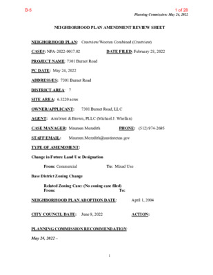
Planning Commission: May 24, 2022 NEIGHBORHOOD PLAN AMENDMENT REVIEW SHEET DATE FILED: February 28, 2022 NEIGHORHOOD PLAN: Crestview/Wooten Combined (Crestview) CASE#: NPA-2022-0017.02 PROJECT NAME: 7301 Burnet Road PC DATE: May 24, 2022 ADDRESS/ES: 7301 Burnet Road DISTRICT AREA: 7 SITE AREA: 6.3220 acres OWNER/APPLICANT: 7301 Burnet Road, LLC AGENT: Armbrust & Brown, PLLC (Michael J. Whellan) CASE MANAGER: Maureen Meredith STAFF EMAIL: Maureen.Meredith@austintexas.gov TYPE OF AMENDMENT: Change in Future Land Use Designation PHONE: (512) 974-2695 From: Commercial Base District Zoning Change To: Mixed Use To: Related Zoning Case: (No zoning case filed) From: NEIGHBORHOOD PLAN ADOPTION DATE: CITY COUNCIL DATE: June 9, 2022 PLANNING COMMISSION RECOMMENDATION: May 24, 2022 – 1 April 1, 2004 ACTION: 1 of 28B-5 Planning Commission: May 24, 2022 STAFF RECOMMENDATION: Staff supports the applicant’s request for Mixed Use land use. BASIS FOR STAFF’S RECOMMENDATION: Staff supports the applicant’s request for Mixed Use land use because Burnet Road is an established commercial corridor designated as an Activity Corridor on the Imagine Austin Growth Concept map where mixed use developments are encouraged. The Crestview/Wooten neighborhood plan supports mixed use developments on Anderson Lane and Burnet Road. Section of plan document that supports the applicant’s request. Land Use Objective 2: Encourage the development of neighborhood-serving commercial and mixed use on Anderson Lane and Burnet Road. Both Anderson Lane and Burnet Road are nearly fully developed as commercial corridors. The types of commercial uses vary widely, including numerous auto sale and service establishments and multi-tenant shopping centers. Care should be taken to ensure that redevelopment serves to strengthen these two retail corridors and maintain their utility as shopping districts. The neighborhood generally agrees that mixed-use development is acceptable on Anderson and Burnet. Adding the Neighborhood Mixed Use Building special use to commercial properties should help facilitate some redevelopment and make better use of the smaller commercial lots. Other mixed use options, including the MU overlay and the neighborhood urban center can be added to the large, deep commercial lots on Burnet Road south of Anderson. The existing zoning on the corridors is generally appropriate, but land area intensive. Auto-related uses should be limited to help maintain the retail viability of both corridors. Recommendations 1. Allow the Neighborhood Mixed Use Building special use on all non-freeway commercial corridors. larger than one acre). 2. Add the Mixed Use (MU) Combining District to larger commercial tracts (generally LAND USE DESCRIPTIONS EXISTING LAND USE ON THE PROPERTY Commercial -Lots or parcels containing retail sales, services, hotel/motels and all recreational services that are predominantly privately owned and operated for profit (for example, theaters and bowling alleys). Included are private institutional uses (convalescent homes and rest homes in which medical or surgical services are not a main function of the institution), but not hospitals. 2 2 of 28B-5 Planning Commission: May 24, 2022 Purpose 1. Encourage employment centers, commercial activities, and other non‐ residential development to locate along major thoroughfares; and 2. Reserve limited areas for intense, auto‐oriented commercial uses that are generally not compatible with residential or mixed use environments. Application major highways; and 1. Focus the highest intensity commercial and industrial activities along freeways and 2. Should be used in areas with good transportation access such as frontage roads and arterial roadways, which are generally not suitable for residential development. PROPOSED LAND USE ON THE PROPERTY Mixed Use - An area that is appropriate for a mix of residential and non‐residential uses. Purpose 1. Encourage more retail and commercial services within walking distance of residents; 2. Allow live‐work/flex space on existing commercially zoned land in the neighborhood; 3. Allow a mixture of complementary land use types, which may include housing, retail, offices, commercial services, and civic uses (with the exception of government offices) to encourage linking of trips; 4. Create viable development opportunities for underused center city sites; 5. Encourage the transition from non‐residential to residential uses; 6. Provide flexibility in land use standards to anticipate changes in the marketplace; 7. Create additional opportunities for the development of residential uses and affordable housing; and 8. Provide on‐street activity in commercial areas after 5 p.m. and built‐in customers for local businesses. Application 1. Allow mixed use development along major corridors and intersections; 2. Establish compatible mixed‐use corridors along the neighborhood’s edge 3 3 of 28B-5 Planning Commission: May 24, 2022 3. The neighborhood plan may further specify either the desired intensity of commercial uses (i.e. LR, GR, CS) or specific types of mixed use (i.e. Neighborhood Mixed Use Building, Neighborhood Urban Center, Mixed Use Combining District); 4. Mixed Use is generally not compatible with industrial development, however it may be combined with these uses to encourage an area to transition to a more complementary mix of development types; 5. The Mixed Use (MU) Combining District should be applied to existing residential uses to avoid creating or maintaining a non‐conforming use; and 6. Apply to areas where vertical mixed use development is encouraged such as Core Transit Corridors (CTC) and Future Core Transit Corridors. Yes Yes Imagine Austin Decision Guidelines Compact and Connected Measures Imagine Austin Growth Concept Map: Located close to, within or adjacent to an Imagine Austin Activity Center, Imagine Austin Activity Corridor, or Imagine Austin Job Center as identified on the Growth Concept Map. Name(s) of Activity Center/Activity Corridor/Job Center: • Property has frontage on Burnet Road which is an Activity Corridor Yes Mobility and Public Transit: Located within 0.25 miles of public transit stop and/or light rail station. • Metro Rapid bus and Bus #3 operates on Burnet Road Yes Mobility and Bike/Ped Access: Adjoins a public sidewalk, shared path, and/or bike lane. • There are sidewalks on Burnet Road Yes Connectivity, Good and Services, Employment: Provides or is located within 0.50 miles to goods and services, and/or employment center. • Burnet Road has a large number of commercial businesses Yes Connectivity and Food Access: Provides or is located within 0.50 miles of a grocery store/farmers market. • Walmart (with a grocery store) is less than ½ mile northwest of the property. Yes Connectivity and Education: Is located within 0.50 miles from a public school or university. • Rosedale School is less than ½ mile northwest of the property. Yes Connectivity and Healthy Living: Provides or is located within 0.50 miles from a recreational area, park and/or walking trail. • Beverly S. Sheffield Northwest District Park is approx. ½-mile west of the property. Yes Connectivity and Health: Provides or is located within 0.50 miles of health facility (ex: hospital, urgent care, doctor’s office, drugstore clinic, specialized outpatient care.) • Care Now Urgent Care facility across the street Housing Affordability: Provides a minimum of 10% of units for workforce housing (80% MFI or less) and/or fee in lieu for affordable houses. • Affordability housing to be provided is unknown at this time Yes Housing Choice: Expands the number of units and housing choice that suits a variety of household sizes, incomes, and lifestyle needs of a diverse population (ex: apartments, triplex, granny flat, live/work units, cottage homes, and townhomes) in support of Imagine Austin and the Strategic Housing Blueprint. • Applicant says the proposed mixed use development will include housing opportunities. Yes Mixed Use: Provides mixed use development (minimum 10% residential and 10% non-residential floor area). • Applicant says the proposed development will be mixed use although percentages of uses is unknown at this time. 4 4 of 28B-5 Planning Commission: May 24, 2022 Yes Culture and Creative Economy: Provides or is located within 0.50 miles of a cultural resource (ex: library, theater, museum, cultural center). • North Village Branch Library is approximately one mile north on Steck Ave. 11 Total Number of “Yes’s” Imagine Austin Priority Program Bonus Features (Extra Points) Yes Small Area Plan Policies: Supports applicable Small Area Plans, including the Future Land Use Map, goals, objectives, actions and text. List three small area plan policies that relate to this project. Name of Small Area Plan: • Crestview/Wooten Neighborhood Plan (Crestview) supports Mixed Use land use and zoning on Burnet Road Culture and Historic Preservation: Preserves or enhances a historically and/or culturally significant site. Culture and Creative Economy: Expands Austin’s creative economy (ex: live music venue, art studio, film, digital, theater.) Workforce Development, the Economy and Education: Expands the economic base by creating permanent jobs, especially an industry that is currently not represented in particular area or that promotes a new technology. • The types and number of jobs to be created is unknown at this time. Workforce Development, the Economy and Education: Promotes educational opportunities or workforce development training. • This is unknown at this time. Imagine Austin Priority Program PUD Specific Bonus Features (Extra Points) Public Space Features and Public Art: Incorporates public space features and/or public art into project (Ex: plazas, streetscapes, gardens, and other people-friendly spaces where different ages can socially interact). Integrates and/or Expands Green Infrastructure: Preserves or expands Austin’s green infrastructure (ex: parkland, community gardens, green streets, creeks, stormwater features that mimic natural hydrology) into the urban environment and transportation network. Protects the Environment: Reduces greenhouse gas emissions, water, energy usage, and/or increases waste diversion. Yes Protects Environmentally Sensitive Lands: Protects Austin’s natural resources and environmental systems by limiting land use and transportation development over or near environmentally sensitive areas, preserves open space, and protects natural resources in excess of ordinance requirements. • Property is not located in an environmentally sensitive area of the city Water/Waste Water Infrastructure: Sustainably manages Austin’s water resources and stream corridors through on-site use of storm water, effective landscaping, flood mitigation, and other low-impact development techniques in excess of ordinance requirements. Total Number of “Yes’s” Under Bonus Features 2 5 5 of 28B-5 Planning Commission: May 24, 2022 6 6 of 28B-5 Planning Commission: May 24, 2022 7 7 of 28B-5 Planning Commission: May 24, 2022 IMAGINE AUSTIN GROWTH CONCEPT MAP Definitions Neighborhood Centers - The smallest and least intense of the three mixed-use centers are neighborhood centers. As with the regional and town centers, neighborhood centers are walkable, bikable, and supported by transit. The greatest density of people and activities in neighborhood centers will likely be concentrated on several blocks or around one or two intersections. However, depending on localized conditions, different neighborhood centers can be very different places. If a neighborhood center is designated on an existing commercial area, such as a shopping center or mall, it could represent redevelopment or the addition of housing. A new neighborhood center may be focused on a dense, mixed-use core surrounded by a mix of housing. In other instances, new or redevelopment may occur incrementally and concentrate people and activities along several blocks or around one or two intersections. Neighborhood centers will be more locally focused than either a regional or a town center. Businesses and services—grocery and department stores, doctors and dentists, shops, branch libraries, dry cleaners, hair salons, schools, restaurants, and other small and local businesses—will generally serve the center and surrounding neighborhoods. 8 8 of 28B-5 Planning Commission: May 24, 2022 Town Centers - Although less intense than regional centers, town centers are also where many people will live and work. Town centers will have large and small employers, although fewer than in regional centers. These employers will have regional customer and employee bases, and provide goods and services for the center as well as the surrounding areas. The buildings found in a town center will range in size from one-to three-story houses, duplexes, townhouses, and rowhouses, to low-to midrise apartments, mixed use buildings, and office buildings. These centers will also be important hubs in the transit system. Regional Centers - Regional centers are the most urban places in the region. These centers are and will become the retail, cultural, recreational, and entertainment destinations for Central Texas. These are the places where the greatest density of people and jobs and the tallest buildings in the region will be located. Housing in regional centers will mostly consist of low to high-rise apartments, mixed use buildings, row houses, and townhouses. However, other housing types, such as single-family units, may be included depending on the location and character of the center. The densities, buildings heights, and overall character of a center will depend on its location. Activity Centers for Redevelopment in Sensitive Environmental Areas - Five centers are located over the recharge or contributing zones of the Barton Springs Zone of the Edwards Aquifer or within water-supply watersheds. These centers are located on already developed areas and, in some instances, provide opportunities to address long-standing water quality issues and provide walkable areas in and near existing neighborhoods. State-of-the-art development practices will be required of any redevelopment to improve stormwater retention and the water quality flowing into the aquifer or other drinking water sources. These centers should also be carefully evaluated to fit within their infrastructural and environmental context. Job Centers - Job centers accommodate those businesses not well-suited for residential or environmentally- sensitive areas. These centers take advantage of existing transportation infrastructure such as arterial roadways, freeways, or the Austin-Bergstrom International airport. Job centers will mostly contain office parks, manufacturing, warehouses, logistics, and other businesses with similar demands and operating characteristics. They should nevertheless become more pedestrian and bicycle friendly, in part by better accommodating services for the people who work in those centers. While many of these centers are currently best served by car, the growth Concept map offers transportation choices such as light rail and bus rapid transit to increase commuter options. Corridors - Activity corridors have a dual nature. They are the connections that link activity centers and other key destinations to one another and allow people to travel throughout the city and region by bicycle, transit, or automobile. Corridors are also characterized by a variety of activities and types of buildings located along the roadway — shopping, restaurants and cafés, parks, schools, single-family houses, apartments, public buildings, houses of worship, mixed-use buildings, and offices. Along many corridors, there will be both large and small redevelopment sites. These redevelopment opportunities may be continuous along stretches of the corridor. There may also be a series of small neighborhood centers, connected by the roadway. Other corridors may have fewer redevelopment 9 9 of 28B-5 Planning Commission: May 24, 2022 opportunities, but already have a mixture of uses, and could provide critical transportation connections. As a corridor evolves, sites that do not redevelop may transition from one use to another, such as a service station becoming a restaurant or a large retail space being divided into several storefronts. To improve mobility along an activity corridor, new and redevelopment should reduce per capita car use and increase walking, bicycling, and transit use. Intensity of land use should correspond to the availability of quality transit, public space, and walkable destinations. Site design should use building arrangement and open space to reduce walking distance to transit and destinations, achieve safety and comfort, and draw people outdoors. BACKGROUND: The application was filed on February 28, 2022 which is in-cycle for neighborhood planning areas located on the west side of I.H.-35. The applicant proposes to change the future land use map from Commercial to Mixed Use. No associated zoning case has been filed. PUBLIC MEETINGS: The ordinance-required community was held virtually held on April 20, 2022. The recorded meeting can be found at https://www.speakupaustin.org/npa. Approximately 1033 meeting notices were mailed to people who rent or own property within 500 feet of the subject tract in addition to neighborhood and environmental groups who requested notification for the area. Two city staff members attended, Maureen Meredith and Mark Walters. Michael Whellan and April Brown from Armbrust and Brown, the applicant’s agents, were also in attendance along with twenty people from the neighborhood. After staff gave a brief presentation describing the plan amendment request, Michael Whellan, the applicant’s agent, made the following presentation and answered attendees’ questions. A copy of his presentation is at the back of this report. These are highlights from Michael Whellan’s presentation. His full presentation is at the back of this report: • We filed the application in February which is open filing period for properties west of • We propose to change the future land use map from Commercial to Mixed Use. • When we file the rezoning application, we will come back to the neighborhood to discuss the zoning case. • The property is located on Burnet Road which is an Activity Corridor and is also on the Austin Strategic Mobility Plan as a transit priority corridor. The city uses these to guide growth to add residential entitlements to commercially zoned properties. Imagine Austin Comprehensive Plan seeks to increase the percentage of mixed use developments along activity corridors. • • The site is about half a mile from Anderson Lane and is currently a strip shopping • Burnet Road has one of two metro rapid bus routes in the city. • Two of the primary bus routes that serve the site are on the top ten bus routes in the IH-35. center. city. 10 10 of 28B-5 Planning Commission: May 24, 2022 • There are several bus routes within a ½-mile radius from the site and travel north to the Domain and south to Downtown. • On the Crestview future land use map, 2/3rds of the Crestview frontage are designated as mixed use. Our site is surrounded by mixed use and is the only property with commercial land use. • Since the plan was approved in 2004, City Council has been updating the FLUM for these frontage lots to align with the planning principles of mixed use along this corridor. Q: Has a survey been done as to what is actually needed? We have a lot of buildings that not being used. A: We have read a lot about the housing crisis, so housing is a top priority for the city. Mixed Use would allow for a residential component. I think it’s really more market-driven than survey-driven. Q: What plan are there for the property? A: They don’t have specific plans for the property other than they want to have a residential component. Q: How tall could the buildings be? A: Right now, with the current zoning we are limited to 60 feet. Q: Will it be something like the Triangle with commercial on the bottom and residential on the top? A: That is one possibility. Mixed use allows some flexibility to do a mixed use project with either all commercial, all residential or a mix of both as long as your base zoning entitlements allow it. Q: Will the units be rented or sold? Also, VMU has not been done well. A: VMU has been one of the most successful affordable housing programs outside of the University Overlay. If you’re talking about ground floor commercial use not doing well, I think most people would agree with you. Most of the housing is for rent because State Law give credit liability for the architect and engineer involved in the building of a condo that is sold with a liability for 10 years, which is why most housing being built is for rent. Q: Will the parking be underground or above: A: We have not made a decision on this yet. Q: What is the maximum percentage that could be residential? A: With VMU it eliminates the site area requirement, and it requires at least one floor over the commercial be residential. Q: When are the current leases ending? A: I don’t have the exact dates, I think they are staggered, so it won’t happen immediately. Q: Has there been any analysis of jobs lost? 11 11 of 28B-5 Planning Commission: May 24, 2022 A: This would be something that would come up during the redevelopment process when we are seeking to rezone and when we look at the types of businesses that might be on the ground floor. Q: What parking requirements will be met? A: We will meet the parking requirements in the Code based on the uses. However, VMU buildings with affordable housing allow for a reduced minimum parking but it’s difficult to finance a project if there is not enough parking because lenders and equity partners aren’t going to participate in a building that doesn’t have enough parking. Also, because the property is in the urban core, there is an opportunity for a 20% reduction in parking. Q: Will this development improve bike facilities along Burnet Road: A: Burnet Road is on a bike priority network so improvements will be made but that depends on money being available. Q: Is the property currently for sale? A: No, they don’t have it for sale right now. Q: How many stories is 60 feet? A: About five stories. Comments: • Safe to say the city's vision for Burnet Road is out of alignment with many local residents, especially longtime owners. Blocking out the sun like what 5350 Burnet looks like, is not appreciated. • When the Dallas Nightclub was open, the inadequate parking ended up on many of the streets in Allandale. • My frustration is that the property taxes are going up and up. This whole thing is pricing out long time Native and other Austinites. • Seems like you don't have much of a plan - lots of questions and no answers or plans - need to get something together! 12 12 of 28B-5 Applicant Summary Letter from Application Planning Commission: May 24, 2022 13 13 of 28B-5 Planning Commission: May 24, 2022 14 14 of 28B-5 Letter of Recommendation from the Neighborhood Plan Contact Team (NPCT) Planning Commission: May 24, 2022 (No letter received as of May 17, 2022) From: Meredith, Maureen Sent: Thursday, April 28, 2022 11:51 AM To: austinchip@hotmail.com; mglavigne@gmail.com Cc: April Brown <ABrown@abaustin.com>; Michael Whellan <MWhellan@abaustin.com> Subject: Crestview NPCT Rec: NPA-2022-0017.02_7301 Burnet Rd Hi, Chip and Mike: The plan amendment case for 7301 Burnet Rd is scheduled for the May 24, 2022 Planning Commission hearing date. If you would like your letter of recommendation added to my staff case report, please email it to me no later than Tuesday, May 17 by 4:30 pm. Thanks. Maureen 15 15 of 28B-5 Planning Commission: May 24, 2022 Site 16 16 of 28B-5 Planning Commission: May 24, 2022 17 17 of 28B-5 Planning Commission: May 24, 2022 18 18 of 28B-5 Planning Commission: May 24, 2022 19 19 of 28B-5 Planning Commission: May 24, 2022 20 20 of 28B-5 Planning Commission: May 24, 2022 Michael Whellan’s Presentation at the April 20, 2022 Community Meeting 21 21 of 28B-5 Planning Commission: May 24, 2022 22 22 of 28B-5 Planning Commission: May 24, 2022 23 23 of 28B-5 Planning Commission: May 24, 2022 24 24 of 28B-5 Planning Commission: May 24, 2022 25 25 of 28B-5 Planning Commission: May 24, 2022 26 26 of 28B-5 Planning Commission: May 24, 2022 27 27 of 28B-5 Planning Commission: May 24, 2022 28 28 of 28B-5