B-13 C14-2022-0017 - Hudson Place; District 1.pdf — original pdf
Backup
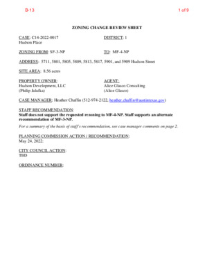
ZONING CHANGE REVIEW SHEET DISTRICT: 1 TO: MF-4-NP CASE: C14-2022-0017 Hudson Place ZONING FROM: SF-3-NP ADDRESS: 5711, 5801, 5805, 5809, 5813, 5817, 5901, and 5909 Hudson Street SITE AREA: 8.56 acres PROPERTY OWNER: Hudson Development, LLC (Philip Jalufka) CASE MANAGER: Heather Chaffin (512-974-2122, heather.chaffin@austintexas.gov) STAFF RECOMMENDATION: Staff does not support the requested rezoning to MF-4-NP. Staff supports an alternate recommendation of MF-3-NP. AGENT: Alice Glasco Consulting (Alice Glasco) For a summary of the basis of staff’s recommendation, see case manager comments on page 2. PLANNING COMMISSION ACTION / RECOMMENDATION: May 24, 2022: CITY COUNCIL ACTION: TBD ORDINANCE NUMBER: 1 of 9B-13 C14-2022-0017 2 ISSUES: No issues at this time. The Applicant is amenable to staff’s recommendation of MF-3-NP. CASE MANAGER COMMENTS: The subject property is located on the south side of Hudson Street approximately 1500 feet west of Ed Bluestein Boulevard. The rezoning tract is zoned SF-3-NP and is comprised of multiple lots. The lots include one single family residence and a mix of undeveloped and commercial properties. SF-3-NP properties are located to the south and west are developed with single family residences. A single family property to the east is developed with a commercial land use. Further to the east are properties zoned GR-MU-NP and CS-NP that include undeveloped lots and lots developed with automotive repair and vehicle storage land uses. Across Hudson Street to the north are properties zoned CS-MU-NP, LI-NP, IP-NP that are developed with a mix of land uses including automotive repair services, plant nursery, and religious assembly. Northwest of the subject property are SF-3-NP zoned residential properties and a P-NP property that contains Travis County International Cemetery. Please see Exhibits A and B- Zoning Map and Aerial Exhibit. Staff does not support the requested MF-4-NP zoning at this location and supports MF-3-NP as an alternate recommendation. The scale of MF-3-NP zoning is more appropriate for a multifamily development that is surrounded by single family residential properties on three sides. Multifamily zoning at this location will increase the number of housing units in the area and increase the mix of housing options. This reflects priorities outlined in the Council adopted Strategic Housing Blueprint. BASIS FOR RECOMMENDATION 1. Council. 2. Council or Planning Commission. 3. development intensities. 4. opportunities or providing for affordable housing. EXISTING ZONING AND LAND USES: Zoning should promote a transition between adjacent and nearby zoning districts, land uses, and Zoning should promote clearly-identified community goals, such as creating employment The rezoning should be consistent with the policies and principles adopted by the City The proposed zoning should be consistent with the goals and objectives of the City Site North South East ZONING SF-3-NP SF-3-NP, P-NP, CS- MU-NP, LI-NP, IP-NP SF-3-NP SF-3-NP, GR-MU-NP, CS-NP SF-3-NP LAND USES Single family residential, Undeveloped, Commercial Single family residential, Cemetery, Automotive repair services, Undeveloped, Plant nursery, Religious assembly Single family residential Commercial, Undeveloped, Automotive repair services, Vehicle storage Single family residential West NEIGHBORHOOD PLANNING AREA: East MLK Combined NP (MLK-183) 2 of 9B-13 C14-2022-0017 3 TIA: Deferred to time of site plan, if required. WATERSHED: Fort Branch NEIGHBORHOOD ORGANIZATIONS: Austin Heritage Tree Foundation Austin Innercity Alliance Bike Austin Claim Your Destiny Foundation East Austin Conservancy Friends of Austin Neighborhoods FRS Property Owners Association Homeless Neighborhood Association Lincoln Garden Association Neighbors United for Progress Reissig Group Sierra Club Austin Regional Group East MLK Combined Neighborhood Association AREA CASE HISTORIES: NUMBER REQUEST SF-3-NP to SF-6-NP C14-2019-0107.SH 5511, 5515, 5517, and 5519 Jackie Robinson St. C14-2017-0097 1321 Delano St, 5600 Jackie Robinson Ln EXISTING STREET CHARACTERISTICS: SF-3-NP to SF-6-NP ADDITIONAL STAFF COMMENTS: Comprehensive Planning Austin Independent School District Austin Neighborhoods Council Black Improvement Association Del Valle Community Coalition East MLK Contact Team Friends of Northeast Austin Hog Pen NA Jackie Robinson Acres M.E.T.S.A. Neighborhood Assn Preservation Austin Seltexas Truman Heights Neighborhood Assn ZAP/PLANNING COMMISSION 6/23/2020: To grant SF-6-NP as rec., on consent 01-23-2018 Apvd SF- 6-CO-NP with max 62 du, NTA RC CITY COUNCIL 7/30/2020: To grant SF-6 as rec., on consent 02-15-2018 Grant SF-6-CO- NP as rec by PC Yes Imagine Austin Decision Guidelines Compact and Connected Measures Imagine Austin Growth Concept Map: Located close to, within or adjacent to an Imagine Austin Activity Center, Imagine Austin Activity Corridor, or Imagine Austin Job Center as identified on the Growth Concept Map. Name(s) of Activity Center/Activity Corridor/Job Center: Mobility and Public Transit: Located within 0.25 miles of public transit stop and/or light rail station. Mobility and Bike/Ped Access: Adjoins a public sidewalk, shared path, and/or bike lane. 3 of 9B-13 C14-2022-0017 4 Connectivity, Good and Services, Employment: Provides or is located within 0.50 miles to goods and services, and/or employment center. Connectivity and Food Access: Provides or is located within 0.50 miles of a grocery store/farmers market. Connectivity and Education: Is located within 0.50 miles from a public school or university. Y Connectivity and Healthy Living: Provides or is located within 0.50 miles from a recreational area, park and/or walking trail. Connectivity and Health: Provides or is located within 0.50 miles of health facility (ex: hospital, urgent care, doctor’s office, drugstore clinic, specialized outpatient care.) Housing Affordability: Provides a minimum of 10% of units for workforce housing (80% MFI or less) and/or fee in lieu for affordable house. Y Housing Choice: Expands the number of units and housing choice that suits a variety of household sizes, incomes, and lifestyle needs of a diverse population (ex: apartments, triplex, granny flat, live/work units, cottage homes, and townhomes) in support of Imagine Austin and the Strategic Housing Blueprint. Mixed Use: Provides mixed use development (minimum 10% residential and 10% non-residential floor area). Culture and Creative Economy: Provides or is located within 0.50 miles of a cultural resource (ex: library, theater, museum, cultural center). Total Number of “Yes’s” Imagine Austin Priority Program Bonus Features (Extra Points) Small Area Plan Policies: Supports applicable Small Area Plans, including the Future Land Use Map, goals, objectives, actions and text. List three small area plan policies that relate to this project. E MLK COMBINED NP (MLK 183 NP) Culture and Historic Preservation: Preserves or enhances a historically and/or culturally significant site. Culture and Creative Economy: Expands Austin’s creative economy (ex: live music venue, art studio, film, digital, theater.) Workforce Development, the Economy and Education: Expands the economic base by creating permanent jobs, especially an industry that is currently not represented in particular area or that promotes a new technology. Workforce Development, the Economy and Education: Promotes educational opportunities or Y workforce development training. 3 Total Number of “Yes’s” Under Bonus Features Applicable Small Area Plan Policies: OBJECTIVE 2: Design multi-family residential projects to be compatible with adjacent single- family areas. (pgs 24-25) - MLK NP Design Guidelines • Guideline 2.1: Multi-family buildings less than 100 feet in width on any street-facing side are more in keeping with the scale of the neighborhood. Building facades that express the interior organization of suites or structural bays relate better to the scale of single-family houses. Goal Two - Promote a mix of land uses that respect and enhance the existing neighborhood and address compatibility between residential, commercial, and industrial uses. (p 44) Goal Five - Provide housing that helps maintain the social and economic diversity of residents. (p 45) Objective 5.1: Allow a mix of residential types on larger tracts having access to major roadways. Environmental 1. The site is not located over the Edwards Aquifer Recharge Zone. The site is located in the Fort Branch Creek Watershed of the Colorado River Basin, which is classified as an Urban 4 of 9B-13 C14-2022-0017 5 Watershed by Chapter 25-8 of the City's Land Development Code. 2. Zoning district impervious cover limits apply in the Urban Watershed classification. 3. According to floodplain maps there is no floodplain within or adjacent to the project location. 4. Standard landscaping and tree protection will be required in accordance with LDC 25-2 and 25-8 for all development and/or redevelopment. 5. At this time, site specific information is unavailable regarding vegetation, areas of steep slope, or other environmental features such as bluffs, springs, canyon rimrock, caves, sinkholes, and wetlands. 6. This site is required to provide on-site water quality controls (or payment in lieu of) for all development and/or redevelopment when 8,000 s.f. cumulative is exceeded, and on site control for the two-year storm. Site Plan General SP1. A site plan will be required for any new development other than single-family, two-family or duplex residential. SP2. Any new development is subject to the design standards in Subchapter E of the Land Development Code. Additional comments will be made when the site plan is submitted. SP3. This site will be subject to the multifamily density provisions in 25-2-563. SP4. Any development which occurs in an SF-6 or less restrictive zoning district which is located 540-feet or less from property in an SF-5 or more restrictive zoning district will be subject to compatibility development regulations. Compatibility Standards SP5. The site is subject to compatibility standards. Along the east, south and west property lines, the following standards apply: No structure may be built within 25 feet of the property line. No parking or driveways are allowed within 25 feet of the property line. No structure in excess of two stories or 30 feet in height may be constructed within 50 feet of the property line. No structure in excess of three stories or 40 feet in height may be constructed within 100 feet of the property line. For a structure more than 100 feet but not more than 300 feet from property zoned SF-5 or more restrictive, the height is limited to 40 feet plus one foot for each 10 feet of distance in excess of 100 feet from the property zoned SF-5 or more restrictive. For a structure more than 300 feet but not more than 540 feet from property zoned SF-5 or more restrictive, the height is limited to 60 feet plus one foot for each four feet of distance in excess of 300 feet from the property zoned SF-5 or more restrictive. A fence, berm, or dense vegetation must be provided to screen adjoining properties from views of parking, mechanical equipment, storage, and refuse collection. An intensive recreational use, including a swimming pool, tennis court, ball court, or playground, may not be constructed 50 feet or less from adjoining SF-3 property. Additional design regulations will be enforced at the time a site plan is submitted. Demolitions SP6. The applicant is responsible for requesting demolition or relocation permits upon site plan approval. The City of Austin Historic Preservation Officer will review all proposed building demolitions and relocations prior to site plan approval. If a building is deemed to meet city 5 of 9B-13 C14-2022-0017 6 historic criteria, the Historic Landmark Commission may initiate a historic zoning case on the property. Airport Overlay SP7. The site is located within the Controlled Compatible Land Use Area of the Austin-Bergstrom Airport. No use will be allowed that creates electrical interference with navigational signals or radio communications between airport and aircraft, makes it difficult for pilots to distinguish between the airport lights and others, results in glare in the eyes of pilots using the airport, impairs visibility in the vicinity of the airport, creates bird strike hazards or otherwise in any way endangers or interferes with the landing, taking off, or maneuvering of aircraft intending to use the Austin-Bergstrom Airport. Height limitations and incompatible uses with each Airport Overlay zone are established in the Airport Overlay Ordinance. Airport Hazard Zoning Committee review may be required prior to Planning Commission Hearing. Hazardous Pipeline Ordinance SP8. Due to its presence within the Hazardous Pipelines overlay, this site is subject to the Hazardous Pipeline Ordinance. Development in a restricted pipeline area is regulated by Sec. 25-2-516. Review by the Fire Department will be required for any proposed development. Before a person may place a road, surface parking lot, or utility line in a restricted pipeline area, the person must deliver to the Director a certification by a registered engineer stating that the proposed construction activity and structure are designed to prevent disturbing the pipeline or impeding its operation. Neighborhood Planning Area SP9. This site is located in the East MLK Combined Neighborhood Plan. Please see the City’s Neighborhood Plans and Resources webpage for a copy of the recommended design guidelines. Transportation ASMP Assessment The Austin Strategic Mobility Plan (ASMP) calls for 60’ feet of right-of-way for Hudson St. It is recommended that 30’ feet of right-of-way from the existing centerline should be dedicated for Hudson St. according to the ASMP at the time of subdivision or site plan application. [LDC 25-6-51 and 25-6- 55]. Transportation Assessment Assessment of required transportation mitigation, including the potential dedication of right of way and easements and participation in roadway and other multi-modal improvements, will occur at the time of site plan application. A traffic impact analysis shall be required at the time of site plan if triggered per LDC 25-6-113. A Neighborhood Traffic Analysis shall be required at the time of site plan, if triggered, when land uses and intensities will be known. if triggered per LDC 25-6-114. The adjacent street characteristics table is provided below: Parks & Recreation PR1: Parkland dedication will be required for the new residential units proposed by this development, multifamily with MF-4-NP zoning, at the time of subdivision or site plan, per City Code § 25-1-601. Whether the requirement shall be met with fees in-lieu or dedicated land will be determined using the criteria in City Code Title 25, Article 14, as amended. Should fees in-lieu be required, those fees shall be 6 of 9B-13 C14-2022-0017 7 used toward park investments in the form of land acquisition and/or park amenities within the surrounding area, per the Parkland Dedication Operating Procedures § 14.3.11 and City Code § 25-1- 607 (B)(1) & (2). If the applicant wishes to discuss parkland dedication requirements in advance of site plan or subdivision applications, please contact this reviewer: thomas.rowlinson@austintexas.gov. At the applicant’s request, PARD can provide an early determination of whether fees in-lieu of land will be allowed. Water Utility AW1. The landowner intends to serve the site with City of Austin water and wastewater utilities. The landowner, at own expense, will be responsible for providing any water and wastewater utility improvements, offsite main extensions, utility relocations and or abandonments required by the land use. The water and wastewater utility plan must be reviewed and approved by Austin Water for compliance with City criteria and suitability for operation and maintenance. Based on current public infrastructure configurations, it appears that service extension requests (SER) will be required to provide service to this lot. Service Extension Requests 5387 (W) and 5388 (WW) are submitted for review but not approved. For more information pertaining to the Service Extension Request process and submittal requirements contact the Austin Water SER team at ser@austintexas.gov. The landowner must pay the City inspection fee with the utility construction. The landowner must pay the tap and impact fee once the landowner makes an application for a City of Austin water and wastewater utility tap permit. AW2. 30 TAC §285, §15-5, §15-9: City records indicate a portion of the site is served by an On-Site Sewage Facility (OSSF). The owner must connect the site to city wastewater service through the cutover process. For more information pertaining to the wastewater cutover process, contact the AW OSSF team at OSSF@austintexas.gov or call (512)-972-0050. INDEX OF EXHIBITS TO FOLLOW A: Zoning Map B. Aerial Exhibit 7 of 9B-13 02-0142.002 SF-6-NP C14-2019-0107.SH LR-NP SF-3-NP 02-0142.002 02-0142.002 SP-97-0384C P-NP N L L E X A P-NP SP-96-0028C 02-0142.002 R82-33 LI-NP SP-2007-0458C 02-0142.002 IP-NP 02-0142.002 SF-3-NP R82-33 02-0142.002 NPA-2014-0015.01 ( ( ( ( ( ( ( SP-2007-0264C 02-0142.002 SP-03-0486C WILC A B R D SP-06-0179C SP07-0158C LI-NP 85-300 ! ! ! ! ! CS-MU-CO-NP ! ! ! ! ! ! ! ! ! ! ! ! ! ! C14-02-0142.002 ! ! ! ! ! SF-3-NP ! ! ! ! ! ! ! ! ! ! ! ! ! ! ! !! ! H U ! D S O ! N S T ! ! ! ! LI-NP SP-98-0437C R82-33 SP96-0355C ( IP-NP R82-33 R EIN D T S E BLU SP-2007-0324C R82-33 C14-02-0142.002 ( ( ( IP-NP ( CS-NP ( ( SP89-0895C LI-NP GR-MU-NP C14-02-0142.002 H A R O L D C T ( CS-NP 78-06 ( ( ( 77-165 HILL LN E N N TA P84-013 C14-02-0142.002 ( ( ( ( SF-3-NP ( ( ( ( 02-0142.002 SF-3-NP ( ( ( ( ( F O R T B R A N C H B L V D ( ( ( 02-0142.002 ( SF-3-NP ( ( ( ( ( ( ( ( ( ( ( ( ( ( D E L A N O S T ( ( ( ( ( ( ( ( SF-3-NP ( ( ( ( ( ( ( ( ( ( ( ( ( ( ( ( ( ( ( ( ( ( ( ( ( ( SF-3-NP ( ( ( ( ( ( ( ( ( ( ( ( ( ( ( ( ( ( ( E L E A N O R S T ( ( ( ( ( ( ( ( ( ( ( ( ( ( ( ( ( ( ( ( ( ( ( ( ( ( ( ( ( ( ( ( ( ( ( ( ( ( ( ( ( ( ( ( ( ( ( ( ( ( ( ( ( ( ( ( ( ( H A R ( OLD C ( T ( ( ( ( ( ( ( ( ( ( CS-NP ( ( ( ( ( LE ( D E S M A R ( ( C14-02-0142.002 ( ( ( ( ( ( ( ( ( ( ( ( ( ( ( ( ( ( R TIE D RIS H C ( ( ( SF-3-NP ( ( ( ( ( ( ( ( D ( ( ( ( ( ( R Y D R R E T ( ( ( ( ( ( ( ( T U R A L N ( ( ( ( ( SF-3-NP CS-NP ± SUBJECT TRACT ! ! ! ! ! ! PENDING CASE ZONING BOUNDARY ZONING ZONING CASE#: C14-2022-0017 This product is for informational purposes and may not have been prepared for or be suitable for legal, engineering, or surveying purposes. It does not represent an on-the-ground survey and represents only the approximate relative location of property boundaries. 1 " = 400 ' This product has been produced by the Housing and Planning Department for the sole purpose of geographic reference. No warranty is made by the City of Austin regarding specific accuracy or Created: 2/22/2022 8 of 9B-13 ( ( SF-3-NP ( ( ( ( ( ( SF-3-NP T O S N A L E D ( ( ( ( ( ( ( ( ( ( ( ( M23 P-NP ( ( SF-3-NP ( ( ( SP-2007-0264C 02-0142.002 SP-03-0486C LI-NP NPA-2014-0015.01 SP-06-0179C WILC A B R D R82-33 SP07-0158C LI-NP 85-300 ! ! ! ! ! ! CS-MU-CO-NP ! H ! U D S ! O N S ! T ! ! ! ! ! C14-02-0142.002 ! ! ! ! SF-3-NP ! C14-2022-0017 M22 ! ! ! ! ! ! ! ! ! ! ! ! ! ! ! ! ! ! ! ! ! ! ! ! ! ! !! IP-NP CS-NP GR-MU-NP SF-3-NP H A R O L D C T CS-NP ± 1 " = 200 ' SUBJECT TRACT ZONING BOUNDARY ! ! ! ! ! ! PENDING CASE CREEK BUFFER Hudson Place ZONING CASE#: LOCATION: SUBJECT AREA: GRID: MANAGER: C14-2022-0017 5711-5909 Hudson St 8.56 Acres M22 Heather Chaffin This product has been produced by the Housing and Planning Department for the sole purpose of geographic reference. No warranty is made by the City of Austin regarding specific accuracy or completeness. Created: 5/16/2022 9 of 9B-13