B-01 C14-2022-0003 - Clayton Lane Residences, District 4.pdf — original pdf
Backup
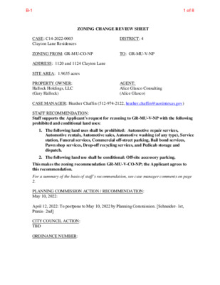
ZONING CHANGE REVIEW SHEET CASE: C14-2022-0003 Clayton Lane Residences DISTRICT: 4 ZONING FROM: GR-MU-CO-NP TO: GR-MU-V-NP ADDRESS: 1120 and 1124 Clayton Lane SITE AREA: 1.9635 acres PROPERTY OWNER: Hallock Holdings, LLC (Gary Hallock) AGENT: Alice Glasco Consulting (Alice Glasco) CASE MANAGER: Heather Chaffin (512-974-2122, heather.chaffin@austintexas.gov) STAFF RECOMMENDATION: Staff supports the Applicant’s request for rezoning to GR-MU-V-NP with the following prohibited and conditional land uses: 1. The following land uses shall be prohibited: Automotive repair services, Automotive rentals, Automotive sales, Automotive washing (of any type), Service station, Funeral services, Commercial off-street parking, Bail bond services, Pawn shop services, Drop-off recycling services, and Pedicab storage and dispatch. 2. The following land use shall be conditional: Off-site accessory parking. This makes the zoning recommendation GR-MU-V-CO-NP; the Applicant agrees to this recommendation. For a summary of the basis of staff’s recommendation, see case manager comments on page 2. PLANNING COMMISSION ACTION / RECOMMENDATION: May 10, 2022: April 12, 2022: To postpone to May 10, 2022 by Planning Commission. [Schneider- 1st, Praxis- 2nd] CITY COUNCIL ACTION: TBD ORDINANCE NUMBER: 1 of 8B-1 C14-2022-0003 2 ISSUES: The Applicant has agreed to keep the prohibited and conditional land uses that are currently on the property. The Applicant has also agreed to add other land uses to the list of prohibited uses as requested by the Neighborhood. The property is currently developed with one single family house and 16 2-bedroom apartments; the Applicant proposes redeveloping the site with 50 2-bedroom apartments and 245 1-bedroom apartments. The Applicant has provided information regarding occupancy and displacement. Please see Exhibit C- Displacement Information. CASE MANAGER COMMENTS: The subject property is located one lot northwest of the intersection of Clayton Lane and Cameron Road. The GR-MU-CO-NP zoned property is currently developed with one single family residence and multifamily residences as described in the Issues section above. Immediately east of the property, at the intersection of Clayton Lane and Cameron Road is a property zoned GR-MU-V-CO-NP that is developed with automotive sales land use. To the north and west of the subject property is land zoned GO-MU-CO-NP that is developed with office uses. Further northwest along Clayton Lane is a small single family residential neighborhood zoned SF-3-NP and a multifamily property zoned MF-4-NP. Directly across Clayton Lane to the south is property zoned GR-MU-V-CO-NP that is developed with multifamily residential. Also across Clayton Lane are properties zoned GR-MU-CO-NP, MF- 4-NP and CS-MU-CO-NP that are developed with multifamily residential land use. Please see Exhibits A and B- Zoning Map and Aerial Exhibit. As stated previously, the rezoning tract is one lot west of Cameron Road, which is a Core Transit Corridor. While the east side of Cameron Road is primarily a residential neighborhood zoned SF-3-NP, All of the properties along the west side of Cameron Road include the V/VMU designation. Staff supports adding the V/VMU designation to the subject property because it is contiguous with this VMU corridor. By extending the V/VMU one lot further along Clayton Lane matches the depth of the VMU corridor across Clayton Lane. As stated in the Issues section, the Applicant proposes redeveloping the site to provide approximately 300 multifamily units. If developed under VMU, the property would be required to include affordable units as well. This reflects goals and priorities that have been identified in the Strategic Housing Blueprint. BASIS FOR RECOMMENDATION 1. The proposed zoning should be consistent with the goals and objectives of the City Council. Granting of the request should result in an equal treatment of similarly situated properties. 2. Zoning should promote clearly-identified community goals, such as creating employment opportunities or providing for affordable housing. 3. 2 of 8B-1 C14-2022-0003 3 The addition of affordable residential units on this site would be consistent with the goals of the City Council as outlined in the Strategic Housing Blueprint and other Council-approved actions. EXISTING ZONING AND LAND USES: Site North South East West ZONING GR-MU-CO-NP GO-MU-NP GR-MU-V-CO-NP GR-MU-V-CO-NP GO-MU-NP, SF-3-NP LAND USES Single family residential, Multifamily residential Administrative/Business/Professional offices Multifamily residential Automotive sales Administrative/Business/Professional offices, Single family residential NEIGHBORHOOD PLANNING AREA: University Hills/Windsor Park Combined NPA (Windsor Park) TIA: Deferred to time of site plan, if triggered. WATERSHED: Fort Branch NEIGHBORHOOD ORGANIZATIONS: Austin Independent School District Austin Neighborhoods Council Friends of Austin Neighborhoods Neighborhood Empowerment Foundation Responsible Growth for Windsor Park SELTexas Windsor Park Neighborhood Association AREA CASE HISTORIES: There are no recent rezoning cases in the area. EXISTING STREET CHARACTERISTICS: Austin Lost and Found Pets Del Valle Community Coalition Homeless Neighborhood Association Neighbors United for Progress Preservation Austin Sierra Club, Austin Regional Group Windsor Park NPCT ADDITIONAL STAFF COMMENTS: Environmental 1. The site is not located over the Edwards Aquifer Recharge Zone. The site is located in the Fort Branch Watershed of the Colorado River Basin, which is classified as an Urban Watershed by Chapter 25-8 of the City's Land Development Code. 2. Zoning district impervious cover limits apply in the Urban Watershed classification. 3 of 8B-1 C14-2022-0003 4 3. According to floodplain maps there is a floodplain within or adjacent to the project location. Based upon the location of the floodplain, offsite drainage should be calculated to determine whether a Critical Water Quality Zone exists within the project location. 4. Standard landscaping and tree protection will be required in accordance with LDC 25-2 and 25-8 for all development and/or redevelopment. 5. At this time, site specific information is unavailable regarding vegetation, areas of steep slope, or other environmental features such as bluffs, springs, canyon rimrock, caves, sinkholes, and wetlands. 6. This site is required to provide on-site water quality controls (or payment in lieu of) for all development and/or redevelopment when 8,000 s.f. cumulative is exceeded, and on site control for the two-year storm. Site Plan SP1. Site plans will be required for any new development other than single-family or duplex residential. SP2. Any development which occurs in an SF-6 or less restrictive zoning district which is located 540 feet or less from property in an SF-5 or more restrictive zoning district will be subject to compatibility development regulations. SP3. Any new development is subject to Subchapter E. Design Standards and Mixed Use. Additional comments will be made when the site plan is submitted. Compatibility Standards SP4. The site is subject to compatibility standards due to SF-3-NP lots being roughly 260 feet from the west property line and 300 feet from the east property line. Overlay Districts SP5. The site is within the following overlay districts: Windsor Park Neighborhood Planning Overlay. Please reference https://www.austintexas.gov/page/adopted-neighborhood-planning-areas-0 for additional information. Residential Design Standards Overlay. Please reference https://www.austintexas.gov/department/residential-design-compatibility-standards for additional information. ADU Approximate Area Reduced Parking Overlay. Please reference https://www.austintexas.gov/page/accessory-dwelling-units for additional information. Non-conforming Signs Ordinance Area Overlay. Please reference https://library.municode.com/tx/austin/codes/code_of_ordinances?nodeId=TIT25LADE_ CH25-10SIRE_ART7SPSI_S25-10-152NOSI for additional information. Parks & Recreation PR1: Parkland dedication will be required for the new residential units proposed by this development, multifamily with GR-MU-V-NP zoning, at the time of subdivision or site plan, per City Code § 25-1-601. The requirement may be met fees in-lieu, as determined using the criteria in City Code Title 25, Article 14, as amended. Those fees shall be used toward park investments in the form of land acquisition and/or park amenities within the surrounding area, per the Parkland Dedication Operating Procedures § 14.3.11 and City Code § 25-1-607 (B)(1) & (2). 4 of 8B-1 C14-2022-0003 5 If the applicant wishes to discuss parkland dedication requirements in advance of site plan or subdivision applications, please contact this reviewer: thomas.rowlinson@austintexas.gov. At the applicant’s request, PARD can provide an early determination of the parkland dedication requirements. Transportation ASMP Assessment The Austin Strategic Mobility Plan (ASMP) calls for 70 feet of right-of-way for Clayton Lane. It is recommended that 35 feet of right-of-way from the existing centerline should be dedicated for Clayton Lane according to the Transportation Plan prior to 3rd reading of City Council. [LDC 25-6-51 and 25-6-55]. Transportation Assessment Assessment of required transportation mitigation, including the potential dedication of right of way and easements and participation in roadway and other multi-modal improvements, will occur at the time of site plan application. A traffic impact analysis shall be required at the time of site plan if triggered per LDC 25-6-113. The adjacent street characteristics table is provided below: Water Utility AW1. The landowner intends to serve the site with City of Austin water and wastewater utilities. The landowner, at own expense, will be responsible for providing any water and wastewater utility improvements, offsite main extensions, utility relocations and or abandonments required by the land use. The water and wastewater utility plan must be reviewed and approved by Austin Water for compliance with City criteria and suitability for operation and maintenance. Based on current public infrastructure configurations, it appears that service extension requests (SER) will be required to provide service to this lot. For more information pertaining to the Service Extension Request process and submittal requirements contact the Austin Water SER team at ser@austintexas.gov . The landowner must pay the City inspection fee with the utility construction. The landowner must pay the tap and impact fee once the landowner makes an application for a City of Austin water and wastewater utility tap permit. INDEX OF EXHIBITS TO FOLLOW A: Zoning Map B. Aerial Exhibit C. Displacement Information 5 of 8B-1 CS-MU-NP REST. E 290 WB TO IH 35 SVRD RAMP C14-2011-0115 E 290 WB TO IH 35 SB RAMP E US 290 HWY WB SHOPPING CENTER CAR SALES MOTEL 80-234 OFFICE BLDG. N IH 35 TO E 290 EB RAMP E US 290 HWY SVRD EB E 290 EB TO SHERIDAN RAMP C 9 06 7-0 9 P S CS-MU-NP CS-1-NP CS-MU-NP 71-265 GR-MU-NP CS-MU-NP NP-2011-0029 R D D A D I L A C SP94-0108C 56-67 56-39 CS-MU-NP CS-NP 290 SVRD WB TO IH 35 S RAMP E US 290 HWY SVRD WB E US 290 HWY EB DISCOUNT STORE DISCOUNT STORE 71-315 E V A N A D R E H S I SF-3-NP LO-NP MF-4-NP ( ( ( SF-3-NP ( ( B R O A D ( VIE W S T ( ( ( ( ( SF-3-NP ( ( ( ( ( R O S E M ( ( ( O N T ST ( ( ( ( ( SF-3-NP ( SF-3-NP ( ( ( CLA YT O ( ( N LN ( ( ( SP96-0400C CS-MU-NP SP96- 0400C CS-MU-V-NP S P - 0 3 - 0 2 C14-2008-0044 0 9 C S P CS-V-NP CS-V-NP 7 3 - 8 7 P A R K I N G F A S T CS-V-NP 9 3 - 0 3 9 3 C A U T O R E P A I R ( ( ( ( ( ( ( ( ( GO-MU-NP OFFICES 72-278 C14-2008-0044 71-71R GO-V-NP PARKING 9 6 72-2 GR-V-NP CP-75-50 ! ! PARKING ! ! ! ! ! ! ! ! 8 0 - 1 9 5 ! ! ! ! ( ! GR-MU-CO-NP ! ( ! ! ! ! GR-MU-V-CO-NP ! GR-MU-V-CO-NP C14-2008-0044 ! D A Y GR-MU-V-CO-NP ! STATIO N ( ( ( ( CP-71-42 CHURCH ( ( ( ( ( ( ( ( ( ( ( ( ( ( ( ( ( SF-3-NP ( ( ( ( ( ( HILL ( C R E S ( ( T D R ( C14-2011-0116 D N R O R E M A C 2008-0044 C14-2008-0044 66-142 GR-V-NP GR-V-NP 25' B U F FE 76-006 74-126 ( R Z O N E D S F-3 ( SF-3-NP ( N W O O G LE ( ( ( ( D D R ( ( ( ( ( SF-3-NP ( ( G LE N C ( ( ( ( R E S T D R ( ( ( ( ( ( ( ( ( ( ( ( ( ( ( ( ( ( ( ( BLDGS. 65-205 MF-4-NP SP-99-0015C 65-205 C14-2020-0064 CS-MU-V-NP CS-1-MU-NP MF-3-NP P83- 008 72-322 GR-MU-CO-NP APTS. ( O FFIC E S CS-MU-NP S E R VIC E S CS-NP CS-MU-H-NP C14H-2021-0116 RETAIL 64-71 PAR KIN G PARKING MF-4-NP CS-MU-CO-NP APTS. APTS. GR-MU-CO-NP DAY CARE GR-MU-V-CO-NP SPC93-0238A R EIN LI S T 99-0093 BANK LR-V-CO-NP CS-MU-NP C14-02-0007 C14-2008-0044 02-0007 CHURCH 2008-0044 ( ( ( SF-3-NP ( ( ( ( ( ( ( ( ( ( ( ( ( D A N B U R Y S Q ( ( ( ( ( R U D A S S A N ( ( ( ( ( ( ( ( ( ( ( ( ( ( SF-3-NP ( ( ( ( ( ( ( ( ( ( ( ( ( ( ( ( ( ( ( SF-3-NP ( ( ( ( ( B E R K S HIR ( ( ( ( E D R ( ( ( ( ( ( ( ( B RIA R CLIFF BLV D ( ( ( ( ( ( ( ( ( ( ( ( ( ( ( ( ( ( HIR E D R ( ( Y O R K S ( ( SF-3-NP ( ( ( ( ( ( SF-3-NP ( ( ( ( ( ( ( ( ( ( ( ( ( ( ( ( ( ( ( ( ( ( ( ( ( ( ( ( ( ( ( ( SF-3-NP ( ( ( ( ( ( ( ( SF-3-NP ( ( ( ( ( ( ( ( ( ( ( R T D S A F ( L E B ( SF-3-NP ( ( ( ( ( ( ( ( ( ( ( ( ( ( ( ( SF-3-NP ( ( ( ( ( B R A E ( ( S RID ( G E D R ( ( SF-3-NP ( ( ( ( ( ( ( ( ( ( SF-3-NP ( ( ( ( ( ( ( ( N O R T H ( ( RID G E D R ( ( ( ( ( ( ( ( ( ( ( ( ( ( ( ( SF-3-NP ( ( ( ( ( ( ( ( ( ( CS-MU-V-CO-NP P 1 4-6 9-0 0 1 C APARTMENTS ( ( ( ( ( ( R I D G E M ( ( O N T D R LO-MU-NP C14-2008-0044.001 2008-0044.001 ( ( ( ( ( ( ( SF-3-NP ( ( SF-3-NP ( ( ( RID G E H ( AV E ( N D R ( ( ( ( ( ( ( ( ( ( ( ( ( ( ( L A R K W ( ( ( SF-3-NP ( ( ( ( ( ( ( O O D D R ( ( ( ( ( ( ( ( ( ( ( WHSE ± SHOPPING CENTER C14-2008-0044 CS-V-NP R Z 8 6-0 36 SP93-0440C SAVIN SP92-0230T G S A N D SP-04-0034C LO A N ( ( SF-3-NP ( ( ( ( ( ( ( SF-3-NP ( SUBJECT TRACT ! ! ! ! ! ! PENDING CASE ZONING BOUNDARY ZONING ZONING CASE#: C14-2022-0003 This product is for informational purposes and may not have been prepared for or be suitable for legal, engineering, or surveying purposes. It does not represent an on-the-ground survey and represents only the approximate relative location of property boundaries. 1 " = 400 ' This product has been produced by the Housing and Planning Department for the sole purpose of geographic reference. No warranty is made by the City of Austin regarding specific accuracy or Created: 1/6/2022 6 of 8B-1 Legend Street Labels Zoning Review Cases- IN REVIEW Capital Metro Bus Routes ASMP Transit Priority Network Core Transit Corridors Zoning Text 0.2 0 0.08 0.2 Miles NAD_1983_StatePlane_Texas_Central_FIPS_4203_Feet Date Printed: This product is for informational purposes and may not have been prepared for or be suitable for legal, engineering, or surveying purposes. It does not represent an on-the-ground survey. This product has been produced by the City of Austin for the sole purpose of geographic reference. No warranty is made by the City of Austin regarding specific accuracy or completeness. 1: 4,800 Notes 7 of 8B-1 From: Alice Glasco Sent: Wednesday, March 23, 2022 10:22 AM To: Chaffin, Heather <Heather.Chaffin@austintexas.gov> Subject: RE: Clayton Lane Residences - Additional Info *** External Email - Exercise Caution *** Heather: See responses below in red: The existing and proposed unit mix Existing: 16- 2 bedrooms Proposed: 50- 2 bedrooms, 245- 1 bedrooms • o o • o Existing # of occupied units 13 occupied, 3 of which are month-to-month, the remainder expire 12/31/2022 Any established displacement program, for example 1st right of return, relocation assistances, etc. All residential leases are scheduled to end on or before 12/31/2022 with no option for renewal. The • o demolition permit application is expected to be submitted for review in May of 2023 and demo to commence in July of 2023. JCI Residential, LLC (the prospective developer) has a new property being built 3.8 miles away called High Point Preserve (located at 9301 E. US Hwy 290, Austin Tx 78724), which has 454 units including 60%, 80%, 100% MFIs and market rate units available. The property currently has 2 buildings open with residents already living there. Construction is still going and opening more buildings as the project progresses. JCI Residential will advertise to the current residents at 1120 & 1124 Clayton Lane (Clayton Lane o Residences) the option to apply at High Point Preserve. Please let me know if you need anything else, thanks! ============================= Alice Glasco, President Alice Glasco Consulting 512-231-8110 W 512-626-4461 C 8 of 8B-1