B-01 - B-03 Citizen Correspondence.pdf — original pdf
Backup

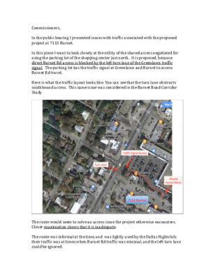
Commissioners, In the public hearing I presented issues with traffic associated with the proposed project at 7113 Burnet. In this piece I want to look closely at the utility of the shared access negotiated for using the parking lot of the shopping center just north. It is proposed, because direct Burnet Rd access is blocked by the left turn lane of the Greenlawn traffic signal. The parking lot has the traffic signal at Greenlawn and Burnet to access Burnet Rd travel. Here is what the traffic layout looks like. You can see that the turn lane obstructs southbound access. This same issue was considered in the Burnet Road Corridor Study The route would seem to solve an access issue the project otherwise encounters. Closer examination shows that it is inadequate. The route was informal at the time, and was lightly used by the Dallas Nightclub; their traffic was at times when Burnet Rd traffic was minimal, and the left turn lane could be ignored. The proposed project will generate trips and traffic is more conflicted times, so the turn lane obstruction is a real issue. The bar traffic was 2 trips per vehicle, enter and exit. Residences generate about 5 trips per day per vehicle. And, the vehicle count will be comparable. The population presented as residents will generate trips that are part of the morning and evening rush, and during mid-day as well. Traffic will not be studied by City Staff until Site Plan Review. That review must consider how Burnet access is provided. The vehicle types, and placement of building portals are controlling issues. Just from customary vehicle use, the shared route through the parking lot will be inadequate. As I said in my presentation, such a route is not in any traffic engineer’s handbook. Here are specific issues. First notice the difference in elevation of the two parking lots. And, that the ramp slopes at about 12% to 16% grade to match the elevations. And, the ramp is constrained on the top side by buildings and customer parking. This forces ramp use to start and end with a turn. For trucks, this is an ‘S’ turn: cab turns in, cab goes to exit while truck tail is still hasn’t entered, cab must start turn to avoid parking and building, truck tail enters ramp and immediately begins turn to exit. As seen here, the route through the parking lot is narrow. The route is only wide enough for a single car at a time. And, the restaurant traffic turn radius prevents widening the route. The main route through the parking lot is not straight, there is a dog-leg. Access into the parking lot from Burnet and Greenlawn is conflicted at the Signal. Public routes depend and require signage and markings that meet traffic standards. This route is private, so signage is and remains inadequate. Where in the pictures is the route marked? How would an Uber know that is the route? Google Maps? And, along with markings and standards, comes liability and law enforcement. Roadway changes are proposed and likely at the intersection. The Burnet Corridor Project design has a raised median replacing the shared turn land in the center of Burnet. That blocks all southbound access., and confounds the traffic generated by the proposed project. That design hurts traffic for 7113 Burnet. The Take Away Conclusion, is that traffic access to the proposed project is a significant problem. It is not solved by the shared access. The problem has several ‘responsible parties’. Approval of the project at the requested scope will result in significant Public expense to resolve the traffic design.