B-01 (NPA-2020-0016.01 - MSC & CTC Tracts NPA; District 3).pdf — original pdf
Backup
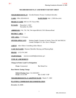
Planning Commission: December 22, 2020 NEIGHBORHOOD PLAN AMENDMENT REVIEW SHEET NEIGHORHOOD PLAN: Govalle/Johnston Terrace Combined (Govalle) CASE#: NPA-2020-0016.01 PROJECT NAME: MSC & CTC Tracts NPA PC DATE: December 8, 2020 DATE FILED: July 1, 2020 (In-cycle) November 24, 2020 ADDRESSES: 748, 750, 760, 764 Airport Blvd & 5301 Glissman Road DISTRICT AREA: 3 SITE AREA: 5.2116 acres OWNER/APPLICANT: Modern Supply Company of Austin, Texas (M. Jack Hall) & Coastal Transport Co., Inc. (Joe A. Morgan) AGENT: Alice Glasco Consulting (Alice Glasco) CASE MANAGER: Maureen Meredith, Housing and Planning Dept. PHONE: (512) 974-2695 STAFF EMAIL: maureen.meredith@austintexas.gov TYPE OF AMENDMENT: Change in Future Land Use Designation From: Commercial Base District Zoning Change To: Mixed Use Related Zoning Case: C14-2020-0073 From: CS-CO-NP To: CS-MU-V-NP NEIGHBORHOOD PLAN ADOPTION DATE: March 27, 2003 PLANNING COMMISSION RECOMMENDATION: December 22, 2020 – 1 NPA-2020-0016.01 1 of 28B-1 Planning Commission: December 22, 2020 December 8, 2020 – Postponed to December 22, 2020 on the consent agenda at the request of the applicant. [P. Howard -1st; C. Hempel – 2nd] Vote: 10-0 [Y. Flores and P. Seeger absent. One vacancy]. November 24, 2020 – Postponed on the consent agenda to December 8, 2020 at the request of the applicant. [P. Seeger – 1st; P. Howard – 2nd] Vote: 9-0 [T. Shaw, J. Shieh, Y. Flores absent. One vacancy]. STAFF RECOMMENDATION: To grant the applicant’s request for Mixed Use land use. BASIS FOR STAFF’S RECOMMENDATION: Staff supports the applicant’s request for Mixed Use because the property is located along Airport Boulevard which is an activity corridor as identified on the Imagine Austin Growth Concept Map where Mixed Use is appropriate. Below are sections of the Govalle/Johnston Terrace Neighborhood Plan that supports the applicant’s request. 2 NPA-2020-0016.01 2 of 28B-1 Planning Commission: December 22, 2020 3 NPA-2020-0016.01 3 of 28B-1 Planning Commission: December 22, 2020 LAND USE DESCRIPTIONS EXISTING LAND USE ON THE PROPERTY Commercial -Lots or parcels containing retail sales, services, hotel/motels and all recreational services that are predominantly privately owned and operated for profit (for example, theaters and bowling alleys). Included are private institutional uses (convalescent homes and rest homes in which medical or surgical services are not a main function of the institution), but not hospitals. Purpose 1. Encourage employment centers, commercial activities, and other non‐ residential development to locate along major thoroughfares; and 2. Reserve limited areas for intense, auto‐oriented commercial uses that are generally not compatible with residential or mixed use environments. Application major highways; and 1. Focus the highest intensity commercial and industrial activities along freeways and 2. Should be used in areas with good transportation access such as frontage roads and arterial roadways, which are generally not suitable for residential development. PROPOSED LAND USE ON THE PROPERTY Mixed Use - An area that is appropriate for a mix of residential and non‐residential uses. Purpose 1. Encourage more retail and commercial services within walking distance of residents; 2. Allow live‐work/flex space on existing commercially zoned land in the neighborhood; 3. Allow a mixture of complementary land use types, which may include housing, retail, offices, commercial services, and civic uses (with the exception of government offices) to encourage linking of trips; 4. Create viable development opportunities for underused center city sites; 5. Encourage the transition from non‐residential to residential uses; 6. Provide flexibility in land use standards to anticipate changes in the marketplace; 4 NPA-2020-0016.01 4 of 28B-1 Planning Commission: December 22, 2020 7. Create additional opportunities for the development of residential uses and affordable housing; and 8. Provide on‐street activity in commercial areas after 5 p.m. and built‐in customers for local businesses. Application 1. Allow mixed use development along major corridors and intersections; 2. Establish compatible mixed‐use corridors along the neighborhood’s edge 3. The neighborhood plan may further specify either the desired intensity of commercial uses (i.e. LR, GR, CS) or specific types of mixed use (i.e. Neighborhood Mixed Use Building, Neighborhood Urban Center, Mixed Use Combining District); 4. Mixed Use is generally not compatible with industrial development, however it may be combined with these uses to encourage an area to transition to a more complementary mix of development types; 5. The Mixed Use (MU) Combining District should be applied to existing residential uses to avoid creating or maintaining a non‐conforming use; and 6. Apply to areas where vertical mixed use development is encouraged such as Core Transit Corridors (CTC) and Future Core Transit Corridors. IMAGINE AUSTIN PLANNING PRINCIPLES 1. Create complete neighborhoods across Austin that provide a mix of housing types to suit a variety of household needs and incomes, offer a variety of transportation options, and have easy access to daily needs such as schools, retail, employment, community services, and parks and other recreation options. • The applicant proposes to build a mixed used development with residential and commercial uses which will provide a variety of housing types, in addition to an affordable housing component. The property is located on a bus route and is near numerous businesses. 2. Support the development of compact and connected activity centers and corridors that are well-served by public transit and designed to promote walking and bicycling as a way of reducing household expenditures for housing and transportation. • The property is located along an activity corridor that has access to public transportation. 5 NPA-2020-0016.01 5 of 28B-1 Planning Commission: December 22, 2020 3. Protect neighborhood character by ensuring context-sensitive development and directing more intensive development to activity centers and corridors, redevelopment, and infill sites. • The property is located along an activity corridor where mixed use development is appropriate, in additional the property is considered an infill site. 4. Expand the number and variety of housing choices throughout Austin to meet the financial and lifestyle needs of our diverse population. • The applicant proposes to build a mixed use development with residential and commercial uses with 10% of the residential units affordable. This proposal will add to the number and variety of housing types. 5. Ensure harmonious transitions between adjacent land uses and development intensities. • The proposed Mixed Use land use is appropriate in this location along an activity corridor. 6. Protect Austin’s natural resources and environmental systems by limiting land use and transportation development over environmentally sensitive areas and preserve open space and protect the function of the resource. • The property is not located in an environmentally sensitive area such as the Drinking Water Protection Zone. 7. Integrate and expand green infrastructure—preserves and parks, community gardens, trails, stream corridors, green streets, greenways, and the trails system—into the urban environment and transportation network. 8. Protect, preserve and promote historically and culturally significant areas. 9. Encourage active and healthy lifestyles by promoting walking and biking, healthy food choices, access to affordable healthcare, and to recreational opportunities. 10. Expand the economic base, create job opportunities, and promote education to support a • Not applicable. • Not applicable. • Not directly applicable. strong and adaptable workforce. • Not directly applicable. creative art forms. • Not applicable. 11. Sustain and grow Austin’s live music, festivals, theater, film, digital media, and new 12. Provide public facilities and services that reduce greenhouse gas emissions, decrease water and energy usage, increase waste diversion, ensure the health and safety of the public, and support compact, connected, and complete communities. • Not applicable. 6 NPA-2020-0016.01 6 of 28B-1 Planning Commission: December 22, 2020 Proximity to Imagine Austin Activity Centers and Corridors 7 NPA-2020-0016.01 7 of 28B-1 Proximity to Parks Planning Commission: December 22, 2020 8 NPA-2020-0016.01 8 of 28B-1 Proximity to Capital Metro Bus Routes and Urban Trails Planning Commission: December 22, 2020 IMAGINE AUSTIN GROWTH CONCEPT MAP Definitions Neighborhood Centers - The smallest and least intense of the three mixed-use centers are neighborhood centers. As with the regional and town centers, neighborhood centers are walkable, bikable, and supported by transit. The greatest density of people and activities in neighborhood centers will likely be concentrated on several blocks or around one or two intersections. However, depending on localized conditions, different neighborhood centers can be very different places. If a neighborhood center is designated on an existing commercial area, such as a shopping center or mall, it could represent redevelopment or the addition of housing. A new neighborhood center may be focused on a dense, mixed-use core surrounded by a mix of housing. In other instances, new or redevelopment may occur incrementally and concentrate people and activities along several blocks or around one or two intersections. Neighborhood centers will be more locally focused than either a regional or a town center. Businesses and services—grocery and department stores, doctors and dentists, shops, branch libraries, dry cleaners, hair salons, schools, restaurants, and other small and local businesses—will generally serve the center and surrounding neighborhoods. 9 NPA-2020-0016.01 9 of 28B-1 Planning Commission: December 22, 2020 Town Centers - Although less intense than regional centers, town centers are also where many people will live and work. Town centers will have large and small employers, although fewer than in regional centers. These employers will have regional customer and employee bases, and provide goods and services for the center as well as the surrounding areas. The buildings found in a town center will range in size from one-to three-story houses, duplexes, townhouses, and rowhouses, to low-to midrise apartments, mixed use buildings, and office buildings. These centers will also be important hubs in the transit system. Job Centers - Job centers accommodate those businesses not well-suited for residential or environmentally- sensitive areas. These centers take advantage of existing transportation infrastructure such as arterial roadways, freeways, or the Austin-Bergstrom International airport. Job centers will mostly contain office parks, manufacturing, warehouses, logistics, and other businesses with similar demands and operating characteristics. They should nevertheless become more pedestrian and bicycle friendly, in part by better accommodating services for the people who work in those centers. While many of these centers are currently best served by car, the growth Concept map offers transportation choices such as light rail and bus rapid transit to increase commuter options. Corridors - Activity corridors have a dual nature. They are the connections that link activity centers and other key destinations to one another and allow people to travel throughout the city and region by bicycle, transit, or automobile. Corridors are also characterized by a variety of activities and types of buildings located along the roadway — shopping, restaurants and cafés, parks, schools, single-family houses, apartments, public buildings, houses of worship, mixed-use buildings, and offices. Along many corridors, there will be both large and small redevelopment sites. These redevelopment opportunities may be continuous along stretches of the corridor. There may also be a series of small neighborhood centers, connected by the roadway. Other corridors may have fewer redevelopment opportunities, but already have a mixture of uses, and could provide critical transportation connections. As a corridor evolves, sites that do not redevelop may transition from one use to another, such as a service station becoming a restaurant or a large retail space being divided into several storefronts. To improve mobility along an activity corridor, new and redevelopment should reduce per capita car use and increase walking, bicycling, and transit use. Intensity of land use should correspond to the availability of quality transit, public space, and walkable destinations. Site design should use building arrangement and open space to reduce walking distance to transit and destinations, achieve safety and comfort, and draw people outdoors. BACKGROUND: The application was filed on July 1, 2020, which is in-cycle for neighborhood planning areas located on the east side of I.H.-35. The applicant proposes to change the land use on the future land use map from Commercial to Mixed Use. The applicant proposes to change the zoning on the property from CS-CO-NP to CS-MU-V- NP to build a mixed use development with commercial and residential uses. The applicant 10 NPA-2020-0016.01 10 of 28B-1 Planning Commission: December 22, 2020 proposes 10% of the residential uses to be affordable. For more information on the proposed zoning, please see case report C14-2020-0073. PUBLIC MEETINGS: The ordinance-required virtual community meeting was held October 6, 2020. Approximately 112 meeting notices were mailed to people who live or own property within 500 feet of the subject tract, in addition to neighborhood organizations and environmental groups who requested notification for the area. Two city staff members participated in the meeting, in addition to Alice Glasco, the agent representing the seller, and David Hartman, the agent representing the buyer of the property along with Ben Browder from Oden Hughes. There were no other attendees from the neighborhood participating in the meeting. David Hartman’s presentation is at the end of this report. The recorded community meeting can be viewed here: https://www.speakupaustin.org/npa. David Hartman said the site is a little over five acres with existing machine welding, steel fabrication and trucking terminal located along Airport Boulevard and Glissman Road. The application was submitted in July 2020 to change the future land use map from Commercial to Mixed Use. In addition there is a proposed change in the zoning to VMU. The proposal is to build a mixed use project with multifamily and commercial uses. One of the benefits of VMU is the requirement that the project bring 10% affordable housing. The site will have access to Glissman Road and Airport Boulevard. David gave an overview of the land uses and zoning surrounding the property noting that the Mixed Use land use and the VMU would be appropriate in this location. The property is on Airport Boulevard which is an Imagine Austin corridor and near three Imagine Austin centers. There is a Capital metro bus stop at subject tract. David then presented the Compatibility Standards chart in the presentation that shows the setbacks required on the property that are triggered by single family to the west and northwest. He said that about 300 feet from the triggering property is where the subject property could achieve a maximum height of 60 feet but it must step down toward the single family property. Under the VMU zoning there is relaxed minimum site area and FAR, but the big difference is VMU brings affordable units for residential project. He then presented the Goals and Recommendations from the Govalle/Johnston Terrace Neighborhood Plan that he said supports the proposed zoning and future land use map change. There were no attendees to the virtual meeting so no questions were asked. CITY COUNCIL DATE: December 10, 2020 ACTION: Postponed to January 27, 2021 at the request of staff January 27, 2021 11 NPA-2020-0016.01 11 of 28B-1 Application Summary Letter Planning Commission: December 22, 2020 12 NPA-2020-0016.01 12 of 28B-1 Planning Commission: December 22, 2020 13 NPA-2020-0016.01 13 of 28B-1 Letter of Recommendation from the Neighborhood Plan Contact Team (NPCT) Planning Commission: December 22, 2020 GOVALLE/JOHNSTON TERRACE NEIGHBORHOOD PLAN CONTACT TEAM “Strength Through Unity” Dec. 15, 2020 To: COA Planning Commission and City Council From: Govalle/Johnston Terrace Neighborhood Plan Contact Team Re: zoning case # NPA-2020-0016.01_MSC & CTC Tracts Dear Commissioners & Council Members, Please accept this letter on behalf of the Govalle/Johnston Terrace Neighborhood Plan Contact team as an expression of: Support for the zoning change with the following conditions, which the Applicant and the Contact Team have agreed to. case # NPA-2020-0016.01_MSC & CTC Tracts at 748 Airport, MSC & CTC Tracts (748 Airport Blvd.) Summary of Community Benefits 1. AFFORDABLE HOUSING. 1. The proposed redevelopment of the MSC & CTC tracts by Oden Hughes will include approximately 330 multifamily units (“Project”). 2. The Project will provide Affordable Housing of 10% of total units at 80% Median Family Income in accordance with City Code Vertical Mixed Use requirements. i. 33 affordable units (10% of 330 units = 33). 2. EAST AUSTIN CONSERVANCY. a. The Project will contribute $297,000 towards East Austin Conservancy (EAC) Family Support Fund. i. EAC Family Support Fund provides that if at least 10% of housing units are affordable at 80% of MFI or less, then developer agrees to donate $1,000 for each market rate unit. 330 units – 33 3. PARKLAND. affordable units = 297 market rate units. 1. The Project will require payment of approximately $507,711.60 in parkland dedication fees ($345,061.20 fee in lieu, plus $162,650.40 park development fee) in connection with site development plan for 330 multifamily units. a i. FY 2021 Parkland Dedication Fees: Fee In-Lieu = $1,045.64 per unit, and Park Development Fee = $492.88 per unit. 2. Oden Hughes agrees to the following in connection with the rezoning case: i. To support earmarking funds from the Project parkland dedication fees described above towards parkland improvements in the neighborhood identified by the Terrace Neighborhood Plan Contact Team at time of site ii. Oden Hughes agrees to $50,000 donation to the Austin Parks Foundation, earmarked for the Govalle/Park improvements project. Govalle/Johnston plan. 14 NPA-2020-0016.01 14 of 28B-1 Planning Commission: December 22, 2020 Please feel free to contact me directly with any questions or comments concerning this case. Thank you, Daniel Llanes, Chair G/JTNP Contact Team 512-431-9665 15 NPA-2020-0016.01 15 of 28B-1 Planning Commission: December 22, 2020 16 NPA-2020-0016.01 16 of 28B-1 Planning Commission: December 22, 2020 17 NPA-2020-0016.01 17 of 28B-1 Planning Commission: December 22, 2020 18 NPA-2020-0016.01 18 of 28B-1 Planning Commission: December 22, 2020 19 NPA-2020-0016.01 19 of 28B-1 David Hartman’s Community Meeting Presentation Planning Commission: December 22, 2020 20 NPA-2020-0016.01 20 of 28B-1 Planning Commission: December 22, 2020 21 NPA-2020-0016.01 21 of 28B-1 Planning Commission: December 22, 2020 22 NPA-2020-0016.01 22 of 28B-1 Planning Commission: December 22, 2020 23 NPA-2020-0016.01 23 of 28B-1 Planning Commission: December 22, 2020 24 NPA-2020-0016.01 24 of 28B-1 Planning Commission: December 22, 2020 25 NPA-2020-0016.01 25 of 28B-1 Planning Commission: December 22, 2020 26 NPA-2020-0016.01 26 of 28B-1 Planning Commission: December 22, 2020 27 NPA-2020-0016.01 27 of 28B-1 Planning Commission: December 22, 2020 28 NPA-2020-0016.01 28 of 28B-1