B-03 (NPA-2020-0005.01 - Montopolis Acres Rezoning; District 3).pdf — original pdf
Backup
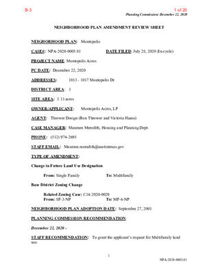
Planning Commission: December 22, 2020 NEIGHBORHOOD PLAN AMENDMENT REVIEW SHEET DATE FILED: July 28, 2020 (In-cycle) 1013 - 1017 Montopolis Dr. NEIGHORHOOD PLAN: Montopolis CASE#: NPA-2020-0005.01 PROJECT NAME: Montopolis Acres PC DATE: December 22, 2020 ADDRESSES: DISTRICT AREA: 3 SITE AREA: 3.13 acres OWNER/APPLICANT: Montopolis Acres, LP AGENT: Thrower Design (Ron Thrower and Victoria Haase) CASE MANAGER: Maureen Meredith, Housing and Planning Dept. PHONE: (512) 974-2695 STAFF EMAIL: Maureen.meredith@austintexas.gov TYPE OF AMENDMENT: Change in Future Land Use Designation From: Single Family Base District Zoning Change To: Multifamily Related Zoning Case: C14-2020-0029 From: SF-3-NP To: MF-6-NP NEIGHBORHOOD PLAN ADOPTION DATE: September 27, 2001 PLANNING COMMISSION RECOMMENDATION: December 22, 2020 - STAFF RECOMMENDATION: To grant the applicant’s request for Multifamily land use. 1 NPA-2020-0005.01 1 of 20B-3 Planning Commission: December 22, 2020 BASIS FOR STAFF’S RECOMMENDATION: Staff supports the applicant’s request for Multifamily land use because the property is located on Montopolis Drive which is a major thoroughfare where multifamily uses are appropriate. The property is less than one mile from the Riverside Station Activity Center and E. Riverside Drive Activity Corridor where the Project Connect Blue Line is proposed to be built. The Montopolis Neighborhood Plan supports a mix of zoning along Montopolis Drive and the creation of multiple house types of varied intensities. LAND USE DESCRIPTIONS EXISTING LAND USE ON THE PROPERTY Single family - Detached or two family residential uses at typical urban and/or suburban densities. Purpose 1. Preserve the land use pattern and future viability of existing neighborhoods; 2. Encourage new infill development that continues existing neighborhood patterns of development; and 3. Protect residential neighborhoods from incompatible business or industry and the loss of existing housing. 2 2 of 20B-3 Planning Commission: December 22, 2020 Application 1. Existing single‐family areas should generally be designated as single family to preserve established neighborhoods; and 2. May include small lot options (Cottage, Urban Home, Small Lot Single Family) and two‐family residential options (Duplex, Secondary Apartment, Single Family Attached, Two‐Family Residential) in areas considered appropriate for this type of infill development. PROPOSED LAND USE ON THE PROPERTY Multifamily Residential - Higher-density housing with 3 or more units on one lot. Purpose 1. Preserve existing multifamily and affordable housing; 2. Maintain and create affordable, safe, and well-managed rental housing; and 3. Make it possible for existing residents, both homeowners and renters, to continue to live in their neighborhoods. 4. Applied to existing or proposed mobile home parks. Application 1. Existing apartments should be designated as multifamily unless designated as mixed use; 2. Existing multifamily-zoned land should not be recommended for a less intense land use category, unless based on sound planning principles; and 3. Changing other land uses to multifamily should be encouraged on a case-by-case basis. IMAGINE AUSTIN PLANNING PRINCIPLES 1. Create complete neighborhoods across Austin that provide a mix of housing types to suit a variety of household needs and incomes, offer a variety of transportation options, and have easy access to daily needs such as schools, retail, employment, community services, and parks and other recreation options. • The applicant propose to rezone the property for a multifamily development which will provide additional housing choices for the area and the City. The property is near public transportation. A public park and a recreation center is across the street to the west. Montopolis Drive is a commercial corridor with a mix of zoning and land uses that includes various commercial businesses. 3 3 of 20B-3 Planning Commission: December 22, 2020 2. Support the development of compact and connected activity centers and corridors that are well-served by public transit and designed to promote walking and bicycling as a way of reducing household expenditures for housing and transportation. • The property is located near public transportation. A public park and a recreation center is across the street to the west. Montopolis Drive is a commercial corridor with a mix of zoning and land uses that includes various commercial businesses. 3. Protect neighborhood character by ensuring context-sensitive development and directing more intensive development to activity centers and corridors, redevelopment, and infill sites. • The property is located less than one mile from the Riverside Station Activity Center and E. Riverside Drive which is an activity corridor where the Project Connect Blue Line is proposed. The property is an infill site along Montopolis Drive where multifamily land use and zoning is appropriate. 4. Expand the number and variety of housing choices throughout Austin to meet the financial and lifestyle needs of our diverse population. • The applicant’s proposed multifamily zoning will provide additional housing choices for the area and the City. 5. Ensure harmonious transitions between adjacent land uses and development intensities. • The property is located on Montopolis Drive that has a mix of land uses where Multifamily land use is appropriate. 6. Protect Austin’s natural resources and environmental systems by limiting land use and transportation development over environmentally sensitive areas and preserve open space and protect the function of the resource. • The property is not located in an environmentally sensitive area such as the Drinking Water Protection Zone. 7. Integrate and expand green infrastructure—preserves and parks, community gardens, trails, stream corridors, green streets, greenways, and the trails system—into the urban environment and transportation network. 8. Protect, preserve and promote historically and culturally significant areas. • To staff’s knowledge there is no historic or cultural significance to this • Not applicable. property. 9. Encourage active and healthy lifestyles by promoting walking and biking, healthy food choices, access to affordable healthcare, and to recreational opportunities. 10. Expand the economic base, create job opportunities, and promote education to support a • Not directly applicable. strong and adaptable workforce. • Not applicable. 4 4 of 20B-3 11. Sustain and grow Austin’s live music, festivals, theater, film, digital media, and new Planning Commission: December 22, 2020 12. Provide public facilities and services that reduce greenhouse gas emissions, decrease water and energy usage, increase waste diversion, ensure the health and safety of the public, and support compact, connected, and complete communities. creative art forms. • Not applicable. • Not applicable. Proximity to Imagine Austin Comprehensive Plan Activity Corridors and Centers 5 5 of 20B-3 Planning Commission: December 22, 2020 Proximity to Parks 6 6 of 20B-3 Proximity to Capital Metro Bus Routes Planning Commission: December 22, 2020 IMAGINE AUSTIN GROWTH CONCEPT MAP Definitions Neighborhood Centers - The smallest and least intense of the three mixed-use centers are neighborhood centers. As with the regional and town centers, neighborhood centers are walkable, bikable, and supported by transit. The greatest density of people and activities in neighborhood centers will likely be concentrated on several blocks or around one or two intersections. However, depending on localized conditions, different neighborhood centers can be very different places. If a neighborhood center is designated on an existing commercial area, such as a shopping center or mall, it could represent redevelopment or the addition of housing. A new neighborhood center may be focused on a dense, mixed-use core surrounded by a mix of housing. In other instances, new or redevelopment may occur incrementally and concentrate people and activities along several blocks or around one or two intersections. Neighborhood centers will be more locally focused than either a regional or a town center. Businesses and services—grocery and department stores, doctors and dentists, shops, branch libraries, dry cleaners, hair salons, schools, restaurants, and other small and local businesses—will generally serve the center and surrounding neighborhoods. Town Centers - Although less intense than regional centers, town centers are also where many people will live and work. Town centers will have large and small employers, although 7 7 of 20B-3 Planning Commission: December 22, 2020 fewer than in regional centers. These employers will have regional customer and employee bases, and provide goods and services for the center as well as the surrounding areas. The buildings found in a town center will range in size from one-to three-story houses, duplexes, townhouses, and rowhouses, to low-to midrise apartments, mixed use buildings, and office buildings. These centers will also be important hubs in the transit system. Job Centers - Job centers accommodate those businesses not well-suited for residential or environmentally- sensitive areas. These centers take advantage of existing transportation infrastructure such as arterial roadways, freeways, or the Austin-Bergstrom International airport. Job centers will mostly contain office parks, manufacturing, warehouses, logistics, and other businesses with similar demands and operating characteristics. They should nevertheless become more pedestrian and bicycle friendly, in part by better accommodating services for the people who work in those centers. While many of these centers are currently best served by car, the growth Concept map offers transportation choices such as light rail and bus rapid transit to increase commuter options. Corridors - Activity corridors have a dual nature. They are the connections that link activity centers and other key destinations to one another and allow people to travel throughout the city and region by bicycle, transit, or automobile. Corridors are also characterized by a variety of activities and types of buildings located along the roadway — shopping, restaurants and cafés, parks, schools, single-family houses, apartments, public buildings, houses of worship, mixed-use buildings, and offices. Along many corridors, there will be both large and small redevelopment sites. These redevelopment opportunities may be continuous along stretches of the corridor. There may also be a series of small neighborhood centers, connected by the roadway. Other corridors may have fewer redevelopment opportunities, but already have a mixture of uses, and could provide critical transportation connections. As a corridor evolves, sites that do not redevelop may transition from one use to another, such as a service station becoming a restaurant or a large retail space being divided into several storefronts. To improve mobility along an activity corridor, new and redevelopment should reduce per capita car use and increase walking, bicycling, and transit use. Intensity of land use should correspond to the availability of quality transit, public space, and walkable destinations. Site design should use building arrangement and open space to reduce walking distance to transit and destinations, achieve safety and comfort, and draw people outdoors. BACKGROUND: The application was filed on July 28, 2020 which is in-cycle for neighborhood planning areas located on the east side of I.H.-35. The application proposes to change the future land use map from Single Family to Multifamily land use. The applicant proposes to change the zoning on the property from SF-3-NP to MF-6-NP for a multifamily development. 8 8 of 20B-3 Planning Commission: December 22, 2020 PUBLIC MEETINGS: The ordinance-required community meeting was virtually held on November 5, 2020. Approximately 347 meeting notices were mailed to people who own property or have a utility account within 500 feet of the property, including community organizations and environmental groups who requested notification for this area on the City’s Community Registry. Two city staff members attended the meeting, including Ron Thrower and Victoria Haase from Thrower Design and two additional people associated with the plan amendment and zoning change applications. There were no attendees from the community at large. After city staff gave a brief presentation about the proposed plan amendment and zoning change applications, the applicant’s agent made the following presentation. Victoria Haase from Thrower Design presented a map of the property in relation to the Imagine Austin Growth Concept map and said the property is over three acres of undeveloped land. Because the land is undeveloped, it will not displace anyone. The proposed zoning is from SF-3-NP to MF-6-NP. The property is located along a major thoroughfare which connects to U. S. Hwy 183 and to E. Riverside Drive which is an Activity Corridor on the Imagine Austin Comprehensive Plan. The property is near existing Capital Metro bus routes and bus stops shown on the map. The property is very well situation to receive an increase in residential density. It will provide greater affordability by providing access to alternative modes of transportation. The property is across the street from a recreational center and a park and is about ½ mile from an activity corridor, E. Riverside Drive, which is a corridor that will receive improvement under the Project Connect that approved this week by Austin residents. All of this is why we believe this property is well- situated to receive additional density than SF-3 would allow. We are asking for MF-6 and we believe MF-6 would allow a level of density that could potentially also contribute some affordability in terms of what units are offered for but obviously how many units can be offered will depend on how many units we can get through the rezoning process for this property. We are here to listen to any comments or concerns you have and try to answer any questions before we get to the public hearings. We make ourselves available for tonight and also beyond tonight through email and by phone. We’d like to do what we can to make this development a win-win for everyone. After Victoria Haase’s presentation, the meeting was opened to questions. There were no attendees to the meeting so no questions were asked. CITY COUNCIL DATE: January 27, 2020 ACTION: 9 9 of 20B-3 Applicant’s Summary Letter Planning Commission: December 22, 2020 10 10 of 20B-3 Planning Commission: December 22, 2020 11 11 of 20B-3 Letter of Recommendation from the Neighborhood Plan Contact Team (NPCT) Planning Commission: December 22, 2020 (No letter was received. See Susan Almanza’s postponement request on the next page with Applicant’s response) 12 12 of 20B-3 Planning Commission: December 22, 2020 Postponement Request from the Montopolis NPCT – Susana Almanza From: Susana Almanza Sent: Wednesday, December 02, 2020 6:35 PM To: Meredith, Maureen <Maureen.Meredith@austintexas.gov> Subject: Re: Montopolis NPCT Rec?: NPA-2020-0005.01_1013-1017 Montopolis Dr *** External Email - Exercise Caution *** Hello Maureen Meredith - The Montopolis Neighborhood Plan Contact Team is requesting a postponement of this case until mid January 2021. This zoning case- 1013-1017 Montopolis Drive has not been heard nor reviewed by the Montopolis Neighborhood Plan Contact Team (MNPCT). The MNPCT regularly scheduled meetings are the last Monday of each month (Dec. 28th). Again, this case has not been presented to the contact team. Susana Almanza, President MNPCT From: Clark, Kate <Kate.Clark@austintexas.gov> Sent: Tuesday, December 15, 2020 9:11 AM To: Victoria <Victoria@throwerdesign.com>; Meredith, Maureen <Maureen.Meredith@austintexas.gov> Cc: Ron Thrower <ront@throwerdesign.com> Subject: RE: Montopolis NPCT Rec?: NPA-2020-0005.01_1013-1017 Montopolis Dr Good Morning Tori, Ms. Almanza has let me know that the MNPCT has agreed to the January 12th PC date. However, while they are agreeing to this date she did tell me that they may not have had time to complete their conversations by then and may request another postponement at that time. We will cross that bridge when we get to it, just providing you the information for transparency. For now, at Planning Commission next week we will offer the neighborhood’s request to postpone to January 12, 2021 on the consent agenda. Please let me know if you have any questions. Kate Clark, AICP, LEED AP Senior Planner City of Austin | Housing and Planning Department Mailing Address: P.O.Box 1088, Austin, Texas 78767 Physical Address: 505 Barton Springs Rd, 5th floor, Austin, Texas 78704 Tel: 512-974-1237 Email: kate.clark@austintexas.gov 13 13 of 20B-3 Planning Commission: December 22, 2020 From: Victoria [mailto:Victoria@throwerdesign.com] Sent: Tuesday, December 15, 2020 10:22 AM To: Clark, Kate <Kate.Clark@austintexas.gov>; Meredith, Maureen <Maureen.Meredith@austintexas.gov> Cc: Ron Thrower <ront@throwerdesign.com> Subject: RE: Montopolis NPCT Rec?: NPA-2020-0005.01_1013-1017 Montopolis Dr Understood. Thank you Kate. Victoria Haase Thrower Design www.throwerdesign.com 510 South Congress Avenue, Suite 207 Mail: P.O. Box 41957 Austin, Texas 78704 512-998-5900 Cell 512-476-4456 Office 14 14 of 20B-3 Planning Commission: December 22, 2020 15 15 of 20B-3 Planning Commission: December 22, 2020 16 16 of 20B-3 Planning Commission: December 22, 2020 17 17 of 20B-3 Planning Commission: December 22, 2020 18 18 of 20B-3 Planning Commission: December 22, 2020 19 19 of 20B-3 Slide Presentation from Applicant’s Agent from the November 5, 2020 Planning Commission: December 22, 2020 20 20 of 20B-3