B-07 (NPA-2020-0016.02 - Trailhead Phase II; District 3).pdf — original pdf
Backup
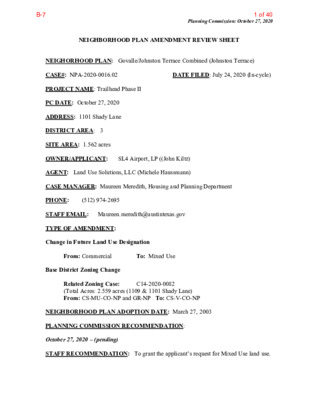
Planning Commission: October 27, 2020 NEIGHBORHOOD PLAN AMENDMENT REVIEW SHEET NEIGHORHOOD PLAN: Govalle/Johnston Terrace Combined (Johnston Terrace) CASE#: NPA-2020-0016.02 DATE FILED: July 24, 2020 (In-cycle) PROJECT NAME: Trailhead Phase II PC DATE: October 27, 2020 ADDRESS: 1101 Shady Lane DISTRICT AREA: 3 SITE AREA: 1.562 acres OWNER/APPLICANT: SL4 Airport, LP ((John Kiltz) AGENT: Land Use Solutions, LLC (Michele Haussmann) CASE MANAGER: Maureen Meredith, Housing and Planning Department PHONE: (512) 974-2695 STAFF EMAIL: Maureen.meredith@austintexas.gov TYPE OF AMENDMENT: Change in Future Land Use Designation From: Commercial To: Mixed Use Base District Zoning Change Related Zoning Case: (Total Acres: 2.559 acres (1109 & 1101 Shady Lane) From: CS-MU-CO-NP and GR-NP To: CS-V-CO-NP C14-2020-0082 NEIGHBORHOOD PLAN ADOPTION DATE: March 27, 2003 PLANNING COMMISSION RECOMMENDATION: October 27, 2020 – (pending) STAFF RECOMMENDATION: To grant the applicant’s request for Mixed Use land use. B-71 of 40 Planning Commission: October 27, 2020 BASIS FOR STAFF’S RECOMMENDATION: The applicant proposes to change the land use on a 1.562 acre tract of land (1101 Shady Lane) from Commercial to Mixed Use land use. The property is part of a zoning application that includes 1109 Shady Lane (0.997 acres) that already has Mixed Use designation on the future land use map, therefore the 1109 Shady Lane tract is not part of this plan amendment application. Staff supports the proposed change to Mixed Use at 1101 Shady Lane because the property is near the Springdale Neighborhood Activity Center and Airport Blvd which is an Activity Corridor where Mixed Use is appropriate. The Govalle/Johnston Terrace Combined Neighborhood Plan supports the diverse range of housing options for the planning area in addition to mixed and balanced land uses. The Plan supports the creation of neighborhood-serving commercial uses within walking distance to residents. Below are sections of the neighborhood plan that supports the applicant’s request. 2 B-72 of 40 Planning Commission: October 27, 2020 3 B-73 of 40 Planning Commission: October 27, 2020 4 B-74 of 40 Planning Commission: October 27, 2020 5 B-75 of 40 Planning Commission: October 27, 2020 LAND USE DESCRIPTIONS EXISTING LAND USE ON THE PROPERTY Commercial -Lots or parcels containing retail sales, services, hotel/motels and all recreational services that are predominantly privately owned and operated for profit (for example, theaters and bowling alleys). Included are private institutional uses (convalescent homes and rest homes in which medical or surgical services are not a main function of the institution), but not hospitals. Purpose 1. Encourage employment centers, commercial activities, and other non‐ residential development to locate along major thoroughfares; and 2. Reserve limited areas for intense, auto‐oriented commercial uses that are generally not compatible with residential or mixed use environments. Application major highways; and 1. Focus the highest intensity commercial and industrial activities along freeways and 2. Should be used in areas with good transportation access such as frontage roads and arterial roadways, which are generally not suitable for residential development. 6 B-76 of 40 Planning Commission: October 27, 2020 PROPOSED LAND USE ON THE PROPERTY Mixed Use - An area that is appropriate for a mix of residential and non‐residential uses. Purpose 1. Encourage more retail and commercial services within walking distance of residents; 2. Allow live‐work/flex space on existing commercially zoned land in the neighborhood; 3. Allow a mixture of complementary land use types, which may include housing, retail, offices, commercial services, and civic uses (with the exception of government offices) to encourage linking of trips; 4. Create viable development opportunities for underused center city sites; 5. Encourage the transition from non‐residential to residential uses; 6. Provide flexibility in land use standards to anticipate changes in the marketplace; 7. Create additional opportunities for the development of residential uses and affordable housing; and 8. Provide on‐street activity in commercial areas after 5 p.m. and built‐in customers for local businesses. Application 1. Allow mixed use development along major corridors and intersections; 2. Establish compatible mixed‐use corridors along the neighborhood’s edge 3. The neighborhood plan may further specify either the desired intensity of commercial uses (i.e. LR, GR, CS) or specific types of mixed use (i.e. Neighborhood Mixed Use Building, Neighborhood Urban Center, Mixed Use Combining District); 4. Mixed Use is generally not compatible with industrial development, however it may be combined with these uses to encourage an area to transition to a more complementary mix of development types; 5. The Mixed Use (MU) Combining District should be applied to existing residential uses to avoid creating or maintaining a non‐conforming use; and 6. Apply to areas where vertical mixed use development is encouraged such as Core 7 B-77 of 40 Planning Commission: October 27, 2020 Transit Corridors (CTC) and Future Core Transit Corridors. IMAGINE AUSTIN PLANNING PRINCIPLES 1. Create complete neighborhoods across Austin that provide a mix of housing types to suit a variety of household needs and incomes, offer a variety of transportation options, and have easy access to daily needs such as schools, retail, employment, community services, and parks and other recreation options. • The applicant proposes a mixed use project with ~8,000 square feet of ground floor retail and 230 multifamily dwelling units with 10% of the unit affordable at 80% of MFI (medium family income). The property is adjacent to the Govalle Neighborhood Public Park and is near numerous businesses and public transportation facilities. 2. Support the development of compact and connected activity centers and corridors that are well-served by public transit and designed to promote walking and bicycling as a way of reducing household expenditures for housing and transportation. • The property is northeast of the intersection of Shady Lane and Bolm Road and is within 200 feet of Airport Blvd which is an activity corridor. The property is on the edge of the Springdale Station neighborhood activity center as identified on the Growth Concept Map of the Imagine Austin Comprehensive Plan. 3. Protect neighborhood character by ensuring context-sensitive development and directing more intensive development to activity centers and corridors, redevelopment, and infill sites. • The property is within 200 feet of Airport Blvd which is identified as an activity corridor on the Growth Concept Map of the Imagine Austin Comprehensive Plan. In addition, the property is within 200 feet of the Springdale Neighborhood Center. It is an infill site once developed will provide services for the area. 4. Expand the number and variety of housing choices throughout Austin to meet the financial and lifestyle needs of our diverse population. • The project is proposing 230 multifamily dwelling units, 10% of which will be available at 80% MFI. 5. Ensure harmonious transitions between adjacent land uses and development intensities. • The applicant’s request for mixed use land use on this tract will be consistent with the property to the north that is part of the associated zoning case. There is mixed use land use to the west, recreation land use (Govalle Park) to the east, commercial land use to the south. Mixed use land use in this location is appropriate. 8 B-78 of 40 Planning Commission: October 27, 2020 6. Protect Austin’s natural resources and environmental systems by limiting land use and transportation development over environmentally sensitive areas and preserve open space and protect the function of the resource. • The property is not located in the Drinking Water Protection zone. 7. Integrate and expand green infrastructure—preserves and parks, community gardens, trails, stream corridors, green streets, greenways, and the trails system—into the urban environment and transportation network. • The property is adjacent to the Govalle Neighborhood Park and urban trail. The developer proposes to expand the urban trail. 8. Protect, preserve and promote historically and culturally significant areas. • To staff’s knowledge there is no historic or cultural significance to this property. 9. Encourage active and healthy lifestyles by promoting walking and biking, healthy food choices, access to affordable healthcare, and to recreational opportunities. • The property is near Govalle Neighborhood Park and near an existing urban trail. The applicant proposes to expand the urban trail. 10. Expand the economic base, create job opportunities, and promote education to support a strong and adaptable workforce. • Not directly applicable. creative art forms. • Not applicable. 11. Sustain and grow Austin’s live music, festivals, theater, film, digital media, and new 12. Provide public facilities and services that reduce greenhouse gas emissions, decrease water and energy usage, increase waste diversion, ensure the health and safety of the public, and support compact, connected, and complete communities. • Not applicable. 9 B-79 of 40 Planning Commission: October 27, 2020 Imagine Austin Comprehensive Plan Activity Corridors and Activity Centers 10 B-710 of 40 Planning Commission: October 27, 2020 Parks in the Vicinity of the Property 11 B-711 of 40 Planning Commission: October 27, 2020 Capital Metro Bus Routes and Urban Trails in the Vicinity of the Property IMAGINE AUSTIN GROWTH CONCEPT MAP Definitions Neighborhood Centers - The smallest and least intense of the three mixed-use centers are neighborhood centers. As with the regional and town centers, neighborhood centers are walkable, bikable, and supported by transit. The greatest density of people and activities in neighborhood centers will likely be concentrated on several blocks or around one or two intersections. However, depending on localized conditions, different neighborhood centers can be very different places. If a neighborhood center is designated on an existing commercial area, such as a shopping center or mall, it could represent redevelopment or the addition of housing. A new neighborhood center may be focused on a dense, mixed-use core surrounded by a mix of housing. In other instances, new or redevelopment may occur incrementally and concentrate people and activities along several blocks or around one or two intersections. Neighborhood centers will be more locally focused than either a regional or a town center. Businesses and services—grocery and department stores, doctors and dentists, shops, branch libraries, dry cleaners, hair salons, schools, restaurants, and other small and local businesses—will generally serve the center and surrounding neighborhoods. 12 B-712 of 40 Planning Commission: October 27, 2020 Town Centers - Although less intense than regional centers, town centers are also where many people will live and work. Town centers will have large and small employers, although fewer than in regional centers. These employers will have regional customer and employee bases, and provide goods and services for the center as well as the surrounding areas. The buildings found in a town center will range in size from one-to three-story houses, duplexes, townhouses, and rowhouses, to low-to midrise apartments, mixed use buildings, and office buildings. These centers will also be important hubs in the transit system. Job Centers - Job centers accommodate those businesses not well-suited for residential or environmentally- sensitive areas. These centers take advantage of existing transportation infrastructure such as arterial roadways, freeways, or the Austin-Bergstrom International airport. Job centers will mostly contain office parks, manufacturing, warehouses, logistics, and other businesses with similar demands and operating characteristics. They should nevertheless become more pedestrian and bicycle friendly, in part by better accommodating services for the people who work in those centers. While many of these centers are currently best served by car, the growth Concept map offers transportation choices such as light rail and bus rapid transit to increase commuter options. Corridors - Activity corridors have a dual nature. They are the connections that link activity centers and other key destinations to one another and allow people to travel throughout the city and region by bicycle, transit, or automobile. Corridors are also characterized by a variety of activities and types of buildings located along the roadway — shopping, restaurants and cafés, parks, schools, single-family houses, apartments, public buildings, houses of worship, mixed-use buildings, and offices. Along many corridors, there will be both large and small redevelopment sites. These redevelopment opportunities may be continuous along stretches of the corridor. There may also be a series of small neighborhood centers, connected by the roadway. Other corridors may have fewer redevelopment opportunities, but already have a mixture of uses, and could provide critical transportation connections. As a corridor evolves, sites that do not redevelop may transition from one use to another, such as a service station becoming a restaurant or a large retail space being divided into several storefronts. To improve mobility along an activity corridor, new and redevelopment should reduce per capita car use and increase walking, bicycling, and transit use. Intensity of land use should correspond to the availability of quality transit, public space, and walkable destinations. Site design should use building arrangement and open space to reduce walking distance to transit and destinations, achieve safety and comfort, and draw people outdoors. BACKGROUND: The application was filed on July 24, 2020, which is in-cycle for neighborhood planning areas located on the east side of I.H.-35. The plan amendment request is to change the future land use map from Commercial to Mixed Use land use. The zoning change application is a request is to change the zoning on the property from CS- MU-CO-NP (1109 Shady Lane) and GR-NP (1101 Shady Lane) to CS-V-NP for a mixed-use 13 B-713 of 40 Planning Commission: October 27, 2020 project. The 0.9970 acres tract of land (1109 Shady Lane) zoned CS-MU-CO-NP has Mixed Use land use so is not part of the plan amendment application. For more information on the proposed zoning case, please see case report for C14-2020-0082. The applicant’s community meeting presentation is near the end of this report with more information on the proposed project. PUBLIC MEETINGS: The ordinance-required virtual community meeting was held on Tuesday, October 6, 2020. Approximately 112 meeting notices were mailed to people who own property or have utility accounts within 500 feet of the property, in addition to neighborhood groups and environmental organizations who requested notification for the area. There were no attendees from the neighborhood. There were two City staff members, Mark Walters and Maureen Meredith and agents representing the property owner, Michele Haussmann and Holly Balmer from Land Use Solutions, LLC. Other attendees were the project architect and the developer. After staff’s presentation, Michele Haussmann, the applicant’s agent, made the following presentation. Michele said she has been working with Govalle/Johnston Terrace NPCT since January 2020 on this project getting their feedback on the project and making changes. [Please see her presentation provided at the end of this report for more details]. The project includes both tracts, the one on Bolm Road and other on Shady Lane, but only 1101 Shady Lane tract is part of the NPA application. The request is to change the FLUM from Commercial to Mixed Use which is consistent with the Mixed Use tract to the north. To the west is property under construction with Mixed Use land use which is also owned by the developer. She said when they first met with the Govalle/Johnston Terrace NPCT, they envisioned 8,000 sf of office space. We eventually came up with an alternative mixed use project with 134,900 sf ground-floor retail with 230 multifamily units, 299 parking space and 6-levels of parking that is wrapped by residential units. The architect for the project participating in the meeting provided additional information on the design of the buildings and changes made through input of the neighborhood. Michele gave an overview of the urban trail on the Govalle Park and the extension proposed by the developer to allow people to go from Govalle Park to downtown without having to be at street level. She also said they are proposing 10% of the apartment units to be available to people who have 80% of MFI. Because there where no participants other than staff and the applicant’s agents, there were no questions and answers as part of the meeting. Please see the presentation made by Michele Haussmann near the end of this report for details on her presentation. 14 B-714 of 40 Planning Commission: October 27, 2020 ACTION: CITY COUNCIL DATE: Not scheduled at this time 15 B-715 of 40 Applicant Summary Letter from Application Planning Commission: October 27, 2020 16 B-716 of 40 Planning Commission: October 27, 2020 17 B-717 of 40 Planning Commission: October 27, 2020 18 B-718 of 40 Planning Commission: October 27, 2020 19 B-719 of 40 Planning Commission: October 27, 2020 Letter of Recommendation from the Neighborhood Plan Contact Team (NPCT) The Govalle/Johnston Terrace NPCT letter will be provided after the team meets on October 24, 2020 to discuss this case. 20 B-720 of 40 Planning Commission: October 27, 2020 21 B-721 of 40 Planning Commission: October 27, 2020 22 B-722 of 40 Planning Commission: October 27, 2020 23 B-723 of 40 Planning Commission: October 27, 2020 Google Maps View: 1101 Shady lane View East Bolm Rd View south of property across Bolm Rd 24 B-724 of 40 Planning Commission: October 27, 2020 Site View west on Bolm Road and Shady Lane 25 B-725 of 40 Michele Haussmann’s Community Meeting Presentation Planning Commission: October 27, 2020 26 B-726 of 40 Planning Commission: October 27, 2020 27 B-727 of 40 Planning Commission: October 27, 2020 28 B-728 of 40 Planning Commission: October 27, 2020 29 B-729 of 40 Planning Commission: October 27, 2020 30 B-730 of 40 Planning Commission: October 27, 2020 31 B-731 of 40 Planning Commission: October 27, 2020 32 B-732 of 40 Planning Commission: October 27, 2020 33 B-733 of 40 Planning Commission: October 27, 2020 34 B-734 of 40 Planning Commission: October 27, 2020 35 B-735 of 40 Planning Commission: October 27, 2020 36 B-736 of 40 Planning Commission: October 27, 2020 37 B-737 of 40 Planning Commission: October 27, 2020 38 B-738 of 40 Planning Commission: October 27, 2020 39 B-739 of 40 Planning Commission: October 27, 2020 40 B-740 of 40