B-05 (NPA-2020-0003.01 - 1804 Ulit Avenue, District 1).pdf — original pdf
Backup
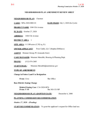
Planning Commission: October 27, 2020 NEIGHBORHOOD PLAN AMENDMENT REVIEW SHEET DATE FILED: July 2, 2020 (In-Cycle) NEIGHORHOOD PLAN: Chestnut CASE#: NPA-2020-0003.01 PROJECT NAME: 1804 Ulit Avenue PC DATE: October 27, 2020 ADDRESS: 1804 Ulit Avenue DISTRICT AREA: 1 SITE AREA: 0.1309 acres (5,702 sq. ft.) OWNER/APPLICANT: Four Caddy, LLC (Stephen DiMarco) AGENT: Drenner Group, PC (Amanda Swor) CASE MANAGER: Maureen Meredith, Housing & Planning Dept. PHONE: STAFF EMAIL: Maureen.Meredith@austintexas.gov TYPE OF AMENDMENT: Change in Future Land Use Designation (512) 974-2695 From: Civic Base District Zoning Change To: Office Related Zoning Case: C14-2020-0074 From: P-NP To: NO-CO-NP NEIGHBORHOOD PLAN ADOPTION DATE: PLANNING COMMISSION RECOMMENDATION: October 27, 2020 – (Pending) STAFF RECOMMENDATION: To grant the applicant’s request for Office land use. December 6, 2000 1 of 30B-5 Planning Commission: October 27, 2020 BASIS FOR STAFF’S RECOMMENDATION: Staff supports the applicant’s request for Office land use because we recognize the need for adaptive reuse of church buildings that are located within residential areas. The property is approximately 260 feet south of E. MLK Jr. Blvd and on the edge of the MLK Station Area TOD. A low-intensity office use in this location in a building that was once a church is an appropriate use. The Chestnut Neighborhood Plan supports compatible infill development and the revitalization of the historic character of the neighborhood. 2 LAND USE DESCRIPTIONS EXISTING LAND USE ON THE PROPERTY Civic - Any site for public or semi fire facilities, hospitals, and public and private schools. Includes major religious facilities and other religious activities that are of a different type and scale than surrounding uses. Purpose 1. Allow flexibility in development for major, multi the greater community; public facilities, including governmental offices, police, functional institutional uses that serve ‐ ‐ 2 of 30B-5 Planning Commission: October 27, 2020 2. Manage the expansion of major institutional uses to prevent unnecessary impacts on established neighborhood areas; 3. Preserve the availability of sites for civic facilities to ensure that facilities are adequate for population growth; 4. Promote Civic uses that are accessible and useable for the neighborhood resident and maintain stability of types of public uses in the neighborhood; 5. May include housing facilities that are accessory to a civic use, such as student dormitories; and 6. Recognize suitable areas for public uses, such as hospitals and schools, that will minimize the impacts to residential areas. Application 1. Any school, whether public or private; 2. Any campus major government administration facilities; 3. Any use that is always public in nature, such as fire and police stations, libraries, and museums; 4. Civic uses in a neighborhood setting that are of a significantly different scale than surrounding non 5. An existing civic use that is likely or encouraged to redevelop into a different land use should NOT be designated as civic; and 6. Civic uses that are permitted throughout the city, such as day care centers and religious assembly, should not be limited to only the civic land use designation. PROPOSED LAND USE ON THE PROPERTY oriented civic facility, including all hospitals, colleges and universities, and civic uses; ‐ ‐ Office - An area that provides for office uses as a transition from residential to commercial uses, or for large planned office areas. Permitted uses include business, professional, and financial offices as well as offices for individuals and non-profit organizations. 1. Encourage office-related services in areas that cannot support the traffic generation of 2. Provide for small lot office conversions as a transition from commercial to residential Purpose commercial uses; uses; and 3 3 of 30B-5 Application Planning Commission: October 27, 2020 3. Preserve sites for employment and office related services. 1. Appropriate for low volume streets such as collectors and minor arterials; and 2. Can be used to provide a transition between residential uses and more intense commercial and industrial uses. IMAGINE AUSTIN PLANNING PRINCIPLES 1. Create complete neighborhoods across Austin that provide a mix of housing types to suit a variety of household needs and incomes, offer a variety of transportation options, and have easy access to daily needs such as schools, retail, employment, community services, and parks and other recreation options. • The property owner is not proposing any housing units on the property, although the property is located within 260 feet of E. MLK Jr. Blvd which is an Activity Corridor that has a mix of uses located on it. 2. Support the development of compact and connected activity centers and corridors that are well-served by public transit and designed to promote walking and bicycling as a way of reducing household expenditures for housing and transportation. • The property is near bus routes that run along E. MLK Jr. Blvd which an Activity Corridor and the metro rail station at MLK TOD to the east. It is within walking and biking distance to services along E. MLK Jr. Blvd and surrounding areas. 3. Protect neighborhood character by ensuring context-sensitive development and directing more intensive development to activity centers and corridors, redevelopment, and infill sites. • The property is within 260 feet of the E. MLK Jr. Blvd Activity Corridor. The property is a redeveloped infill site. 4. Expand the number and variety of housing choices throughout Austin to meet the financial and lifestyle needs of our diverse population. • The property owner is not proposing residential uses on the property. 5. Ensure harmonious transitions between adjacent land uses and development intensities. • Support for an office land use within a residential area is unique, but the adaptive reuse of a small church building is considered by staff to be appropriate in this situation. 4 4 of 30B-5 Planning Commission: October 27, 2020 6. Protect Austin’s natural resources and environmental systems by limiting land use and transportation development over environmentally sensitive areas and preserve open space and protect the function of the resource. • The property is not located in the Drinking Water Protection Zone. 7. Integrate and expand green infrastructure—preserves and parks, community gardens, trails, stream corridors, green streets, greenways, and the trails system—into the urban environment and transportation network. • Not applicable. 8. Protect, preserve and promote historically and culturally significant areas. • To staff’s knowledge, there has been no determination of the historic or cultural significance of the church building. However, staff has received communication from people in the community about the historic and cultural significance the church and what it means to them. If a demolition permit were to ever be submitted, the Historic Preservation staff would make a determination. 9. Encourage active and healthy lifestyles by promoting walking and biking, healthy food choices, access to affordable healthcare, and to recreational opportunities. 10. Expand the economic base, create job opportunities, and promote education to support a • Not directly applicable. strong and adaptable workforce. • Not directly applicable. creative art forms. • Not applicable. 11. Sustain and grow Austin’s live music, festivals, theater, film, digital media, and new 12. Provide public facilities and services that reduce greenhouse gas emissions, decrease water and energy usage, increase waste diversion, ensure the health and safety of the public, and support compact, connected, and complete communities. • Not applicable. 5 5 of 30B-5 Proximity to Imagine Austin Activity Center and Activity Corridors Planning Commission: October 27, 2020 6 6 of 30B-5 Proximity to Park Facilities Planning Commission: October 27, 2020 7 7 of 30B-5 Planning Commission: October 27, 2020 Proximity to Capital Metro Bus Routes, Rail and Urban Trails IMAGINE AUSTIN GROWTH CONCEPT MAP Definitions Neighborhood Centers - The smallest and least intense of the three mixed-use centers are neighborhood centers. As with the regional and town centers, neighborhood centers are walkable, bikable, and supported by transit. The greatest density of people and activities in neighborhood centers will likely be concentrated on several blocks or around one or two intersections. However, depending on localized conditions, different neighborhood centers can be very different places. If a neighborhood center is designated on an existing commercial area, such as a shopping center or mall, it could represent redevelopment or the addition of housing. A new neighborhood center may be focused on a dense, mixed-use core surrounded by a mix of housing. In other instances, new or redevelopment may occur incrementally and concentrate people and activities along several blocks or around one or two intersections. Neighborhood centers will be more locally focused than either a regional or a town center. Businesses and services—grocery and department stores, doctors and dentists, shops, branch libraries, dry cleaners, hair salons, schools, restaurants, and other small and local businesses—will generally serve the center and surrounding neighborhoods. 8 8 of 30B-5 Planning Commission: October 27, 2020 Town Centers - Although less intense than regional centers, town centers are also where many people will live and work. Town centers will have large and small employers, although fewer than in regional centers. These employers will have regional customer and employee bases, and provide goods and services for the center as well as the surrounding areas. The buildings found in a town center will range in size from one-to three-story houses, duplexes, townhouses, and rowhouses, to low-to midrise apartments, mixed use buildings, and office buildings. These centers will also be important hubs in the transit system. Job Centers - Job centers accommodate those businesses not well-suited for residential or environmentally- sensitive areas. These centers take advantage of existing transportation infrastructure such as arterial roadways, freeways, or the Austin-Bergstrom International airport. Job centers will mostly contain office parks, manufacturing, warehouses, logistics, and other businesses with similar demands and operating characteristics. They should nevertheless become more pedestrian and bicycle friendly, in part by better accommodating services for the people who work in those centers. While many of these centers are currently best served by car, the growth Concept map offers transportation choices such as light rail and bus rapid transit to increase commuter options. Corridors - Activity corridors have a dual nature. They are the connections that link activity centers and other key destinations to one another and allow people to travel throughout the city and region by bicycle, transit, or automobile. Corridors are also characterized by a variety of activities and types of buildings located along the roadway — shopping, restaurants and cafés, parks, schools, single-family houses, apartments, public buildings, houses of worship, mixed-use buildings, and offices. Along many corridors, there will be both large and small redevelopment sites. These redevelopment opportunities may be continuous along stretches of the corridor. There may also be a series of small neighborhood centers, connected by the roadway. Other corridors may have fewer redevelopment opportunities, but already have a mixture of uses, and could provide critical transportation connections. As a corridor evolves, sites that do not redevelop may transition from one use to another, such as a service station becoming a restaurant or a large retail space being divided into several storefronts. To improve mobility along an activity corridor, new and redevelopment should reduce per capita car use and increase walking, bicycling, and transit use. Intensity of land use should correspond to the availability of quality transit, public space, and walkable destinations. Site design should use building arrangement and open space to reduce walking distance to transit and destinations, achieve safety and comfort, and draw people outdoors. BACKGROUND: The plan amendment application was filed on July 2, 2020 which is in- cycle for neighborhood planning areas located on the east side of I.H.-35. The applicant proposes to change the land use on the future land use map from Civic to Office land use. The applicant proposes to change the zoning on the property from P-NP (Public – Neighborhood Plan) to NO-CO-NP (Neighborhood Office – Conditional Overlay – 9 9 of 30B-5 Planning Commission: October 27, 2020 Neighborhood Plan) for an administrative and business office. The existing building was once a church, but is now being use as a business office. For more information on the proposed zoning, please see zoning case report C14-2020-0074. PUBLIC MEETINGS: The ordinance-required community meeting was held virtually via Microsoft Teams platform on September 16, 2020. Approximately 231 community meeting notices were mailed to people who own property or have a utility account within 500 feet of the subject property, in addition to neighborhood organizations and environmental groups who requested notification for the area. Five staff members participated in the virtual community meeting, in addition to Amanda Swor and from Drenner Group, the applicant’s agent. Three attendees participated in virtual meeting. After staff gave a presentation outlining the applicant’s plan amendment and zoning change request, Amanda Swor, the applicant’s agent, gave the following presentation. Her presentation is at the end of this report. Amanda said the existing building is a 2600 sq. ft. church-building that was last used as a church in 2014. The building was actively being used as a church during the Chestnut Neighborhood planning process. It was during this process that the property was given the future land use designation of Civic with the zoning of P-NP (Public – Neighborhood Plan. The property owner is seeking to change the FLUM from Civic to Office and to rezone the property from P-NP to NO-CO-NP for the adaptive reuse of the building, which it is being used now as an office building. There are no plans to demolish the building. She said before they submitted the plan amendment and zoning change applications, they met with Chestnut NPCT to get feedback on their proposed requests. This request different because it was a church but in 2014 the owner made conversion to interior of church to make office building. The owners recently found out that the office is not a permitted use in the P- Public zoning district, which is why they are requesting the changes. When they reached out to the Chestnut Neighborhood Plan Contact Team to get support for the adaptive reuse of the property. The NPCT supports the request with the conditional overlay that was added to the zoning application. See the Chestnut NPCT letter provided in this report. Amanda said she was previously asked about parking on the property. There are five parking spaces in the alley and there are two on-street parking spaces in the front of the building. There were no questions from the people who attended the meeting. CITY COUNCIL DATE: Not scheduled at this time. ACTION: 10 10 of 30B-5 Applicant Summary Letter from Application Planning Commission: October 27, 2020 11 11 of 30B-5 Planning Commission: October 27, 2020 12 12 of 30B-5 Letter of Recommendation from the Neighborhood Plan Contact Team (NPCT) Planning Commission: October 27, 2020 13 13 of 30B-5 Planning Commission: October 27, 2020 Letter of Recommendation from Neighborhood Association(s) 14 14 of 30B-5 Planning Commission: October 27, 2020 15 15 of 30B-5 Planning Commission: October 27, 2020 16 16 of 30B-5 Planning Commission: October 27, 2020 17 17 of 30B-5 Planning Commission: October 27, 2020 18 18 of 30B-5 Planning Commission: October 27, 2020 Front view of 1804 Ulit Ave. View west on Ulit Ave 19 19 of 30B-5 Planning Commission: October 27, 2020 View south across the street from 1804 Ulit Ave View east on Ulit Ave 20 20 of 30B-5 Planning Commission: October 27, 2020 Amanda Swor (Applicant Agent’s) Community Meeting Presentation 21 21 of 30B-5 Planning Commission: October 27, 2020 22 22 of 30B-5 Planning Commission: October 27, 2020 23 23 of 30B-5 Planning Commission: October 27, 2020 24 24 of 30B-5 Planning Commission: October 27, 2020 25 25 of 30B-5 Planning Commission: October 27, 2020 26 26 of 30B-5 Planning Commission: October 27, 2020 27 27 of 30B-5 Planning Commission: October 27, 2020 To: City of Austin, Planning and Zoning Department Re: Plan Amendment Case # NPA-2020-0003.01 28 28 of 30B-5 Planning Commission: October 27, 2020 Zoning Case #: C14-2020-0074 I oppose the re-zoning of the property at 1804 Ulit Avenue from P-NP (Pubic district – Neighborhood Plan) to NO-CO-NP (Neighborhood Office district – Conditional Overlay – Neighborhood Plan). This is inappropriate for a Residential Neighborhood. An office or business should be located in a business district or where the land has already been zoned for such. And not disturb the neighborhood by re-zoning the land to (NO-CO-NP). I am not aware of any residential neighborhood in this area or in Austin that has an office right in the center of the neighborhood block. My family has owned the property that I now live at since 1952. This has always been zoned a residential neighborhood, and should stay as such. When you start re-zoning for office, before you know it, the whole block could eventually be rezoned for offices, and you no longer have a nice quiet residential neighborhood. It is just wrong to put an office building in this block, and rezone the land to NO-CO-NP. I propose you leave 1804 Ulit Avenue zoned as it is P-NP. Sincerely, Martha E. White (512) 412-8376 29 29 of 30B-5 Planning Commission: October 27, 2020 (Insert Applicant Criteria Worksheet) 30 30 of 30B-5