B-08 (C14-2020-0072 - IH 35 & US 183 Retail Center; District 4).pdf — original pdf
Backup
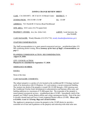
ZONING CHANGE REVIEW SHEET CASE: C14-2020-0072 – IH 35 & US 183 Retail Center DISTRICT: 4 ZONING FROM: CH-CO-NP; CS-NP ADDRESS: 7821 North IH 35 Service Road Northbound SITE AREA: 0.881 acres (38,376 square feet) PROPERTY OWNER: Ave, Inc. (John Coil) TO: CS-NP AGENT: Land Answers, Inc. (Jim Wittliff) CASE MANAGER: Wendy Rhoades (512-974-7719, wendy.rhoades@austintexas.gov) STAFF RECOMMENDATION: The Staff recommendation is to grant general commercial services – neighborhood plan (CS- NP) combining district zoning. For a summary of the basis of Staff’s recommendation, see page 2. PLANNING COMMISSION ACTION / RECOMMENDATION: August 25, 2020: CITY COUNCIL ACTION: Planned to be scheduled for September 17, 2020: ORDINANCE NUMBER: ISSUES: None at this time. CASE MANAGER COMMENTS: The subject property is a portion of a lot located on the northbound IH 35 frontage road just north of its intersection with US Highway 183, and contains a vacant commercial building. The western two-thirds of the property is zoned CH-CO-NP through a 1989 rezoning case; the Conditional Overlay limits development to administrative and business office uses, and building additions to a maximum of 35,000 square feet. The remainder of the property is zoned general commercial services – neighborhood plan (CS-NP). Immediately north of the property are TXDoT Austin District offices and a large maintenance facility. East of the tract is recently cleared land and Travis County Appraisal District offices (CS-NP). Please refer to Exhibits A and A-1 (Zoning Map) and (Aerial Exhibit). The Applicant is proposing to rezone the property to the CS-NP district to provide a consistent set of uses and regulations on the property and redevelop with retail sales uses. 1 of 10B-8 C14-2020-0072 Page 2 BASIS FOR RECOMMENDATION 1. The proposed zoning should be consistent with the purpose statement of the district sought. The general commercial services (CS) district is intended predominantly for commercial and industrial activities of a service nature having operating characteristics or traffic service requirements generally incompatible with residential environments. The CS district is best suited for uses located at intersections of arterial roadways or arterials with collector status. The intention is to promote safe and efficient use of transportation facilities. The neighborhood plan (NP) district denotes a tract located within the boundaries of an adopted Neighborhood Plan. 2. Staff recommends CS-NP zoning for the property based on the following considerations: 1) access is taken to a major arterial roadway and 2) compatibility with the existing zoning pattern and general land use character established at the interchange of IH-35 and US Highway 183. EXISTING ZONING AND LAND USES: The proposed zoning should promote consistency and orderly planning. ZONING CH-CO-NP; CS-NP Site North SF-3-NP South CS-NP East CS-NP West Not Applicable LAND USES Vacant commercial building TXDoT offices and maintenance facility Undeveloped; US 183 northbound service road and main lanes (elevated) Office building; Financial services; Hotel; Automotive repair IH 35 northbound service road and main lanes WATERSHED: Buttermilk Branch – Urban NEIGHBORHOOD PLAN AREA: Heritage Hills / Windsor Hills Combined (Heritage Hills) TIA: Is not required CAPITOL VIEW CORRIDOR: No SCHOOLS: Hart Elementary School NEIGHBORHOOD ORGANIZATIONS: 28 – Georgian Acres Neighborhood Association 114 – North Growth Corridor Alliance 511 – Austin Neighborhoods Council 283 – North Austin Neighborhood Alliance 742 – Austin Independent School District 964 – St. John Neighborhood Association 1228 – Sierra Club, Austin Regional Group Dobie Middle School Northeast Early College High School SCENIC ROADWAY: No 2 of 10B-8 C14-2020-0072 Page 3 1259 – Heritage Hills / Windsor Hills Neighborhood Association 1319 – Heritage Hills / Windsor Hills Neighborhood Plan Contact Team 1363 – SEL Texas 1528 – Bike Austin 1550 – Homeless Neighborhood Association 1616 – Neighborhood Empowerment Foundation 1746 – Go Austin Vamos Austin - North 1774 – Austin Lost and Found Pets 1802 – Central Austin Urbanists AREA CASE HISTORIES: 1422 – St. John Neighborhood Plan Contact Team 1530 – Friends of Austin Neighborhoods 1782 – Austin Mayan Collective NUMBER REQUEST GR-NP to GR-MU- NP C14-2018-0100 – Norwood Park – 916 and 918 Norwood Park Blvd CITY COUNCIL Apvd GR-MU-CO-NP as Commission recommended (6-6-2019). COMMISSION Apvd GR-MU- CO-NP w/CO for Buildings containing residential dwelling units are not permitted within 175' of existing facilities with more than 660 gallons of outdoor, above- ground storage of Class I Flammable or Class II Combustible Liquid storage unless protective measures are approved by AFD To Grant GR-CO w/CO for the TIA, 10’ vegetative buffer on northern property line between Brettonwoods Ln and Furness St GR to GR, to add land area to site C14-01-0100 – Walmart at Norwood Park – 1030 Norwood Park Apvd GR-CO as Commission recommended (01/10/2002). RELATED CASES: The subject property is located within the boundaries of the Heritage Hills / Windsor Hills Combined (Heritage Hills) Neighborhood Planning Area and the –NP combining district was 3 of 10B-8 Capital Metro (within ¼ mile) No C14-2020-0072 Page 4 added at that time (C14-2010-0160 – Ordinance No. 20110113-060). The property is designated as Commercial land use on the Future Land Use Map (FLUM) (NP-2010-0028). On June 29, 1989, Council approved CH-CO zoning for approximately the western two- thirds of the property (C14-89-0018). The Conditional Overlay limited the use of the property to administrative and business offices and limited additions to the existing building to a maximum of 35,000 square feet of gross floor area. The rezoning area consists of a portion of Lot 2, S/W ONE, a subdivision recorded in October 1981 (C8-80-088.1(81)). In April 2018, TXDoT acquired the along the IH 35 frontage road. There are no site plans in process. EXISTING STREET CHARACTERISTICS: Name Classification Sidewalks Pavement ROW Bicycle Route Yes Yes 40 feet Level 4 Approximately 427 feet North IH 35 Service Road Northbound OTHER STAFF COMMENTS: Comprehensive Planning The rezoning case is located on the northeast corner East Anderson Lane (US Highway 183) and the IH 35 Service Road, on a 0.881 acre portion of a lot, which once contained an office building and is next to the Norwood Shopping Center. This case is also located within the Heritage Hills / Windsor Hills Combined Neighborhood Planning Area and is west of Cameron & 183 Center Job Center and north of a Regional Center. Surrounding land uses include a TXDOT office to the north; to the south and west is the IH-35 and US 183 interchange; and to the east is a large office building, a hotel and the Norwood Shopping Center. The proposed use is retail. Connectivity There are public sidewalks located along the IH-35 service road and Anderson Lane. A public transit stop is located 1,600 linear feet from the property. However, due to the fast and heavy traffic along these two highways, the mobility options in this area are below average, while nearby connectivity options (retail and services) are only accessible by a car. Heritage Hills/Windsor Hills Combined Neighborhood Plan (HHWHCNP) The HHWHCNP Future Land Use Map (FLUM) designates this portion of the planning area as ‘Commercial’, which is intended for retail sales, services, motels/hotels, and all 4 of 10B-8 C14-2020-0072 Page 5 recreational services that are predominately privately owned and operated for profit. This FLUM category is intended to encourage employment centers, commercial activities, and other non-residential development. CS zoning is permitted under the Commercial FLUM category. The following policies are taken from the HHWHCNP and are applicable to this case: Objective L3: Promote the revitalization of commercial uses along major roadways. These new places should promote local serving businesses and serve as neighborhood amenities. Pg 41 REC 14: Support commercial or mixed use developments that are neighborhood serving and neighborhood‐friendly (which do not emit noise, pollution, or light, and, do not have a lot of truck traffic/deliveries, or have extended hours of operation), especially when they abut single family subdivisions. (RP: HHWHCNPA, COA) pg 41 REC 17: Support the aesthetic enhancement of the buildings and streetscape along all major corridors of the Planning Areas (i.e. Rutherford Lane, E. Rundberg Lane, E. Braker Lane, Middle Fiskville Road, Cameron ‐ Dessau Road, and the I‐35 frontage road.) REC 18: Support the Norwood Shopping Center, and surrounding properties which are identified as Mixed Use on the FLUM, transitioning to a Neighborhood Urban Center, to provide a mixture of pedestrian friendly, neighborhood serving uses (see Infill Options Map). Objective L4: Establish neighborhood serving mixed use niches along roadways at the edges of single family neighborhoods. (pg 43) REC 20: Transform portions of the Planning Area into neighborhood scale, neighborhood serving mixed use developments (office, retail and residential), which are pedestrian friendly at: (RP: HHWHCNPA, COA) * The east side of Middle Fiskville Road. * Along portions of E. Rundberg Lane. * Along portions of Park Plaza Drive. * Within the Norwood Shopping Center. Objective L6: Support aesthetically appealing redevelopment that improves the appearance of the HHWHCNP. (pg 44) REC 25: Support, throughout the HHWHCNPA, high quality, aesthetically appealing businesses, housing developments, and industrial areas, which strongly emphasize appealing building and landscape design. TEXT: Norwood Shopping Center/Wal‐Mart ‐ #10 A number of neighborhood stakeholders expressed a desire for a greater mixture of uses at this large shopping center; uses which are more neighborhood serving, neighborhood scale, and a move away from ‘big box’ developments, which often do not stay long in an area before closing down or moving. The community supports the redevelopment of the Norwood Shopping Center and adjacent commercial properties to an urban village, which has a mix of uses, including residences and commercial uses. (pg. 48) REC 47: Support the creation of a vibrant, neighborhood urban center where Norwood Shopping Center/Wal‐Mart currently exist (see Infill Options Map) that is pedestrian‐oriented, neighborhood friendly, neighborhood‐scaled and serves neighborhood needs. (RP: COA, HHWHCNPA) 5 of 10B-8 C14-2020-0072 Page 6 REC 48: Coordinate with property owners to encourage aesthetic improvements at the Norwood Shopping Center (e.g., additional policing of trash, additional trash cans, landscaping, and pedestrian improvements, etc.). (RP: COA, HHWHCNPA) The HHWHCNP vision for the Norwood Shopping Center is to develop it into a Neighborhood Urban Center, (or urban village) which would provide a mixture of pedestrian friendly, neighborhood serving uses, and the redevelopment of the existing commercial center or development of a vacant site into a mixed use, pedestrian oriented transit center. The urban village concept in the plan is defined as including residences and commercial uses. The Plan also states that it wants mixed use development in the Norwood Shopping Center, to include this property, should be neighborhood serving, neighborhood‐scaled, and have aesthetic attractive buildings and streetscape. The community supports the redevelopment of the Norwood Shopping Center and adjacent commercial properties to an urban village, which includes a mix of uses. Based on this project offering a retail uses but not a true mixture of use, this proposal appears to partially support the HHWHCNP Plan. Imagine Austin The Imagine Austin Growth Concept Map identifies this property as being near a “Job Center” and is located within an existing neighborhood commercial node as identified in the HHWHCNP. Page 107 of Imagine Austin states, “While most new development will be absorbed by centers and corridors, development will happen in other areas within the city limits to serve neighborhood needs and create complete communities. Infill development can occur as redevelopment of obsolete office, retail, or residential sites or as new development on vacant land within largely developed areas. New commercial, office, larger apartments, and institutional uses such as schools and churches, may also be located in areas outside of centers and corridors. The design of new development should be sensitive to and complement its context.” The following IACP policies are applicable to this case: • LUT P3. Promote development in compact centers, communities, or along corridors that are connected by roads and transit that are designed to encourage walking and bicycling, and reduce health care, housing and transportation costs. • LUT P4. Protect neighborhood character by directing growth to areas of change that includes designated redevelopment areas, corridors and infill sites. Recognize that different neighborhoods have different characteristics and new and infill development should be sensitive to the predominant character of these communities. • HN P11. Protect neighborhood character by directing growth to areas of change and ensuring context sensitive infill in such locations as designated redevelopment areas, corridors, and infill sites. Based upon the Imagine Austin policies above that supports infill development, this project appears to support the Imagine Austin Comprehensive Plan. 6 of 10B-8 C14-2020-0072 Page 7 Drainage The developer is required to submit a pre- and post-development drainage analysis at the subdivision and site plan stage of the development process. The City’s Land Development Code and Drainage Criteria Manual require that the Applicant demonstrate through engineering analysis that the proposed development will have no identifiable adverse impact on surrounding properties. Impervious Cover Within the Buttermilk Branch watershed, the maximum impervious cover allowed by the CS zoning district is 95%, which is based on the zoning regulations. Environmental The site is not located over the Edwards Aquifer Recharge Zone. The site is located in the Buttermilk Branch Watershed of the Colorado River Basin, which is classified as an Urban Watershed by Chapter 25-8 of the City's Land Development Code. It is in the Desired Development Zone. Zoning district impervious cover limits apply in the Urban Watershed classification. According to floodplain maps there is no floodplain within or adjacent to the project location. Standard landscaping and tree preservation will be required in accordance with LDC 25-2 and 25-8 for all development and/or redevelopment. At this time, site specific information is unavailable regarding vegetation, areas of steep slope, or other environmental features such as bluffs, springs, canyon rimrock, caves, sinkholes, and wetlands. This site is required to provide on-site water quality controls (or payment in lieu of) for all development and/or redevelopment when 8,000 s.f. cumulative is exceeded, and on site control for the two-year storm. Site Plan Any new development is subject to Subchapter E. Design Standards and Mixed Use. Additional comments will be made when the site plan is submitted. The site is subject to compatibility standards. Along the north property line, the following standards apply: a. No structure may be built within 25 feet of the property line. b. No structure in excess of two stories or 30 feet in height may be constructed within 50 feet of the property line. 7 of 10B-8 C14-2020-0072 Page 8 c. No structure in excess of three stories or 40 feet in height may be constructed within 100 feet of the property line. d. No parking or driveways are allowed within 25 feet of the property line. e. A landscape area at least 25 feet wide is required along the property line. In addition, a fence, berm, or dense vegetation must be provided to screen adjoining properties from views of parking, mechanical equipment, storage, and refuse collection. Additional design regulations will be enforced at the time a site plan is submitted. Transportation The Austin Strategic Mobility Plan (ASMP), adopted April 11, 2019, recommends that right- of-way dedication be deferred to TxDOT and reviewed with the site plan application. A traffic impact analysis is deferred to the site plan application when land uses and intensities will be finalized. Water / Wastewater The landowner intends to serve the site with City of Austin water and wastewater utilities. The landowner, at own expense, will be responsible for providing any water and wastewater utility improvements, offsite main extensions, utility relocations and or abandonments required by the land use. The water and wastewater utility plan must be reviewed and approved by Austin Water for compliance with City criteria and suitability for operation and maintenance. Depending on the development plans submitted, water and or wastewater service extension requests may be required. All water and wastewater construction must be inspected by the City of Austin. The landowner must pay the City inspection fee with the utility construction. The landowner must pay the tap and impact fee once the landowner makes an application for a City of Austin water and wastewater utility tap permit. INDEX OF EXHIBITS TO FOLLOW Exhibit A: Zoning Map Exhibit A-1: Aerial Map 8 of 10B-8 95-0137 GR-CO-NP C14-95-0137 SP96-0116C FURNITURE SALES GR-NP 73-12 LO-CO-NP ( 9 5 - 0 1 3 7 ( ( SF-3-NP ( ( ( ( R E D G D E L Y A R G ( ( ( ( ( ( ( ( ( ( ( SF-3-NP ( ( ( D AN R OAH D ( ( EN SH ( ( ( ( SF-3-NP ( R U TH ( E R F O R D LN ( CS-1-NP R85-223 SP-94-423C GR-NP N O R W O O D PA R K BLV D GR-MU-CO-NP C14-2018-0140 RETAIL STORE C14-2010-0160 TEXAS HIGHWAY DEPT. NP-2010-0028 DISTRICT 16 HEADQUARTERS SF-3-NP C14-01-0100 ( ( NPA-2018-0026.02 ( MF-4-NP C14-2018-0024 V E D N U ( O FC. S P-95-119C CHURCH 75-109 69-059 MF-3-NP V E ( D N U E W O N SLE OFC. R84-070 74-162 CS-CO-NP RZ85-96 ( 70-046 Y D R 98-0061 B 5 S N IH 3 74-162 RZ85-96 STATION APARTMENTS CS-CO-NP 67-88 MF-2-NP ( LO-MU-NP APTS. 69-118 APTS. P81-005 MF-3-NP FA ST FO O D GR-NP RZ85-20 R R D E N S S E G APARTMENTS O FFIC E S A P T S . .P82-79 GR-NP OFFICES C14-2010-0049 73-126 CARPET SALES SP91-276C UNDEV NP-2010-0026 MF-2-NP 91-91 APARTMENTS E N A I H N D E 3 5 R N S B O T N O L A N N W D E B R E A N D E R S S O N O W SAVINGS & LOANS GR-NP B R A M P SERV. 72-06 STA. N E B T O N 3 5 S B R A M P CS-NP CS-1-NP 71-243 R 8 6 - 6 5 N IH 35 S B T O A N D E R S O N W B R A M P CS-NP R E D S A H Y C V E H C CS-NP P72-03 O FFIC E B UILDIN G LO-NP CS-NP 79-148 73-188 MOTEL 80-99 P M A B R 5 S O IH 3 D T O O W R A B B D S R V 5 S N IH 3 B TO R 5 N N IH 3 P M A D R R FO R E H T U ! A D M I N . O F C . ! ! ! ! ! ! SP88-225C ! ! CH-CO-NP ! ! ! ! ! ! ! MOTEL CS-NP INSURANCE OFFICE 74-40 RESTAURANT EL T O H 96-0155 CS-MU-NP SP-95-0375C SP-01-0385C RESTAURANT HOTEL SP97-0146A T N A C A V SF-3-NP CS-MU-CO-NP C14-95-0126 LO-MU-CO-NP 95-0126 SP C97-0216A 74-017 E G A R O T S CS-MU-NP SP95-0383C D EL M A VA C A NT R A V E T N A C VA ( E V TIN A 9 4-6 7 R A M SF-3-NP B 5 N N IH 3 GR-MU-NP 98-0130 C14-98-0130 G KIN R A P C K S O BL A 80-79 N A V E ( SF-3-NP ( LR-MU-NP C14-02-0125 CS-MU-CO-NP ± CS-MU-NP SUBJECT TRACT ! ! ! ! ! ! PENDING CASE ZONING BOUNDARY OFFICE GR-NP OFFICES OFFICES 74-114 RZ87-41 GR-NP SERVIC R82-45 E STATIO N RZ86-50 E A N D E 78-102 T R A LU N S R S O N L BE S MIS H O P SIO N & N E B E A N D E R S O N LN SV R D W B 69-229 R85-223 D NB R V 5 S N IH 3 C14-2011-0115 REST. TRUCK & MACHINERY NP-2011-0029 RZ86-26 THEATER RZ87-41 TRUCK SERVICES TRUCK REPAIR CS-MU-NP TRUCK TERMINAL SP95-361CS CONTRACTOR'S SUPPLIES & RENTAL TRUCK MACHINERY SALES & REPAIRS GAS STATION YARD CS-NP CS-NP E A N D E 73-85 R S O N L N T LR-NP O C A M E A N D E E R O N R R S O A M P N L ( ( ( ( ( ( N S V R D E B LR-MU-NP C14-2017-0086 NPA-2017-0029.01 ( E V T A SF-3-NP T E N N E B ( 68-103 ( ( ( SF-3-NP ( ( ( ( ( ( ( E V R A E V R A C ( ( P-NP W H E ( ATLE ( Y A V E ( ( SF-3-NP SF-3-NP ( P-NP ( ( SF-3-NP SF-3-NP ZONING Exhibit A ZONING CASE#: C14-2020-0072 SP-03-0418C CH-NP 79-286 C L O C K T O W E R D R CH-CO-NP 951102-Y SP-94-490C SP-94-203C CA M ER O N TO E AN DERSO N W B RAM P SF-3-NP ( ( E V E A N U H T E B ( ( SF-3-NP ( ( 73-85 ( ( E V E A C N E VID O R SF-3-NP P ( ( ( This product is for informational purposes and may not have been prepared for or be suitable for legal, engineering, or surveying purposes. It does not represent an on-the-ground survey and represents only the approximate relative location of property boundaries. 1 " = 400 ' This product has been produced by CTM for the sole purpose of geographic reference. No warranty is made by the City of Austin regarding specific accuracy or completeness. Created: 7/16/2020 9 of 10B-8 5 D O O W R A B T P O IH 3 M A B R S P M O A B T D R R O F R E H T U R N IH 35 N B D N R V 5 S N IH 3 GR-NP A CS-NP 3 B D S R V N IH 35 S CS-1-NP T O A N D E R S O N N IH 35 S B W B R A M P B 5 S N IH 3 E A N I N H D 3 E 5 R S S B O A N T T R N B 5 N N IH 3 SF-3-NP CH-CO-NP C14-2020-0072 2 L28 1 CS-NP 1 B N 5 3 H I N N O S R E D N A O T P M A R B W N E R T T A N B N O S 5 R 3 E IH D N N A 2 CS-MU-NP 1 ± 1'' = 150' SUBJECT TRACT ZONING BOUNDARY ! ! ! ! ! ! PENDING CASE CREEK BUFFER E A N D E R S O N L E A E A N D E N D E R S O R S O N L N L N E B N S V R GR-NP D E B N W B E A N D E R S O N LN S V R D W B 2 3 GR-NP 1 1 1 Copyright nearmap 2015 IH 35 & US 183 Retail Center Exhibit A - 1 ZONING CASE#: LOCATION: SUBJECT AREA: GRID: MANAGER: C14-2020-0072 7821 N IH 35 Service Rd NB .8801 Acres L28 Wendy Rhoades This map has been produced by the Communications Technology Management Dept. on behalf of the Planning Development Review Dept. for the sole purpose of geographic reference. No warranty is made by the City of Austin regarding specific accuracy or completeness. 10 of 10B-8