B-06 (C14-2020-0067 - 3504 S. 1st Street Rezoning; District 3).pdf — original pdf
Backup
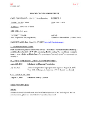
C14-2020-0067 1 ZONING CHANGE REVIEW SHEET CASE: C14-2020-0067 – 3504 S. 1st Street Rezoning DISTRICT: 3 ZONING FROM: CS-CO TO: CS-MU-V-CO ADDRESS: 3504 South 1st Street SITE AREA: 0.84 acres PROPERTY OWNER: Merc Properties LTD (Daryl Kunik) AGENT: Armbrust & Brown,PLLC (Richard Suttle) CASE MANAGER: Kate Clark (512-974-1237, kate.clark@austintexas.gov) STAFF RECOMMENDATION: Staff recommends general commercial services – mixed use – vertical mixed use building – conditional overlay (CS-MU-V-CO) combining district zoning. The conditional overlay is to carry over existing prohibited uses. For a summary of the basis of staff’s recommendation, see page 2. PLANNING COMMISSION ACTION / RECOMMENDATION: August 25, 2020 Scheduled for Planning Commission July 28, 2020 Approved neighborhood’s postponement request to August 25, 2020. Vote: 12-0. [P. Seeger, G. Anderson – 2nd; C. Hampel was absent]. CITY COUNCIL ACTION: August 27, 2020 Scheduled for City Council ORDINANCE NUMBER: ISSUES Staff has received comments both in favor of and in opposition to this rezoning case. For all communication, please see Exhibit C: Correspondence Received. 1 of 12B-6 C14-2020-0067 2 CASE MANAGER COMMENTS: This property is approximately 0.84 acres. Adjacent to the north is a tract zoned CS-V, to the east is South 1st Street and across South 1st Street are tracts zoned MF-3-NP and LR-CO-NP. Adjacent to the south is a tract zoned MF-3 and to the west is SF-3 zoning. This property is subject to an existing Ordinance (20070405-043) which limits the number of trips per day, caps development on the property to 40 feet and prohibits a set of uses. The applicant is requesting to remove the trip limitations and building height restriction but carry over the existing list of prohibited uses. Those uses include the following: Adult-oriented businesses Automotive rentals Automotive repair services Automotive sales Automotive washing (of any kind) BASIS OF RECOMMENDATION: Bail bond services Commercial blood plasma center Convenience storage Pawn shop services Vehicle storage 1. Zoning changes should promote compatibility with adjacent and nearby uses. The proposed zoning should be consistent with the purpose statement of the district sought. The applicant is requesting to rezone from CS-CO to CS-MU-V-CO. This property is in between CS-V and MF-3 zoned tracts. Allowing for a mix of uses on this site would help in transition between zoning districts. Additionally, this property is located on a Core Transit Corridor as defined by the current City Land Development Code. These corridors are roadways that have or will have a sufficient population density, mix of uses, and transit facilities to encourage and support transit use. Because of these parameters they were also used to established where the Vertical Mixed Use (VMU or V) Overlay District was permitted. Rezoning this property to CS-MU-V-CO would be consistent with the existing land use pattern and the purpose statement of the district sought. EXISTING ZONING AND LAND USES: Zoning Land Uses Site CS-CO Single family North CS-V South MF-3 Indoor and Outdoor Entertainment (event center) Multifamily East MF-3-NP and LR-CO-NP Multifamily and Administrative and Business Offices West SF-3 Single family NEIGHBORHOOD PLANNING AREA: Galindo (suspended) 2 of 12B-6 C14-2020-0067 3 TIA: is deferred until site plan submittal if triggered. WATERSHED: West Bouldin Creek and East Bouldin Creek (urban) OVERLAYS: ADU Approximate Area Reduced Parking, Residential Design Standards SCHOOLS: Galindo Elementary, Lively Middle and Travis High Schools. Galindo Elementary Neighborhood Assn. Homeless Neighborhood Association Neighborhood Empowerment Foundation Perry Grid 614 Preservation Austin SELTexas Sierra Club, Austin Regional Group South Austin Commercial Alliance Number Request Commission City Council To add (-V) to base zoning To grant adding (-V) Approved zoning change (1/10/08) NEIGHBORHOOD ORGANIZATIONS Austin Independent School District Austin Lost and Found Pets Austin Neighborhoods Council Bike Austin Dawson Neighborhood Association Dawson Neighborhood Organization Dawson Neighborhood Plan Contact Team Friends of Austin Neighborhoods Galindo Area Patriotic People's Porch AREA CASE HISTORIES: C14-2007-0238 Galindo Elementary Neighborhood Association Vertical Mixed Use (VMU) Zonings Addresses Vary Missing Link Cardinal Lane C14-05-0024 From SF-3 to SF-6 Approved SF-6-CO; CO included max. 30 units, max. 10 units/ acre, max. 55% impervious cover and access. (06-09-05) To grant SF-6-CO; CO included max. 30 units, max. 55% impervious cover, access to streets, no gated communities and City’s Grow Green Landscaping guidelines. 3 of 12B-6 C14-2020-0067 4 Number Request Commission City Council From LR-NP to LR- CO-NP Approved LR-CO-NP as recommended. (3/11/04) To grant LR-CO-NP; CO to make the following uses conditional: service station and drive through services as an accessory use. C14-04-0006 Dawson Mixed Use Building 3507 S. 1st Street RELATED CASES: C14-06-0194: This case rezoned (Ord. No. 20070405-043) the base zoning district from family residence (SF-3) district to general commercial services-conditional overlay (CS-CO) combining district. The CO included a trip limit, maximum height of 40 feet for buildings and list of prohibited uses. EXISTING STREET CHARACTERISTICS: Street ROW Pavement Classification Sidewalks Bike S 1st Street 78’ 40’ ASMP Level 3 Yes Capital Metro (within ¼ mile) Route Shared Lane Yes OTHER STAFF COMMENTS: Comprehensive Planning This rezoning case is located on the west side of South 1st Street, on a 0.84 acres property. It is also located in an area that does not have an adopted neighborhood plan but is located along the South 1st Activity Corridor and is 0.40 miles from the St. Edwards Neighborhood Center. Surrounding land uses include an event center to the north; to the south is an apartment building; to the east is an apartment complex and an office; and to the west are single family houses. Over the last decade, South 1st Street has experienced an acceleration in transitioning away from single family houses to a variety of commercial, office and multifamily uses along this heavily traveled thoroughfare. The proposal calls for a vertical mixed-use project with multifamily and retail uses. Connectivity Public sidewalks are located along South 1st Street and a CapMetro stop is located within 150 feet walking distance of the subject property. Mobility options are average while connectivity options are fair. 4 of 12B-6 C14-2020-0067 5 Imagine Austin The Imagine Austin Growth Concept Map found in the Imagine Austin Comprehensive Plan (IACP) identifies this project as being located along an Activity Corridor. Activity Corridors are characterized by a variety of activities and buildings, which are intended to allow people to reside, work, shop, access services, people watch, recreate, and hang out without traveling far distances. The following IACP policies are relevant to this case: • LUT P3. Promote development in compact centers, communities, or along corridors that are connected by roads and transit that are designed to encourage walking and bicycling, and reduce health care, housing and transportation costs. • LUT P4. Protect neighborhood character by directing growth to areas of change that includes designated redevelopment areas, corridors and infill sites. Recognize that different neighborhoods have different characteristics and new and infill development should be sensitive to the predominant character of these communities. • LUT P5. Create healthy and family-friendly communities through development that includes a mix of land uses and housing types and affords realistic opportunities for transit, bicycle, and pedestrian travel and provides both community gathering spaces, parks and safe outdoor play areas for children. Based upon this property being situated along an Activity Corridor, which supports mixed use, mobility strengths in the immediate vicinity; and the applicable Imagine Austin policies above, this project supports the Imagine Austin Comprehensive Plan. 5 of 12B-6 C14-2020-0067 6 6 of 12B-6 C14-2020-0067 7 Environmental 1. The site is not located over the Edwards Aquifer Recharge Zone. The site is located within the West Bouldin Creek and East Bouldin Creek Watersheds of the Colorado River Basin, which are both classified as Urban Watersheds by Chapter 25-8 of the City's Land Development Code. The site is subject to Interbasin Diversion requirements of the Land Development Code, such that a proposed diversion of stormwater from one watershed to another is limited to less than 20% of the site based on gross site area or less than 1 acre, whichever is smaller. 2. Zoning district impervious cover limits apply in the Urban Watershed classification. 3. According to floodplain maps there is no floodplain within or adjacent to the project location. 4. Standard landscaping and tree protection will be required in accordance with LDC 25-2 and 25-8 for all commercial development and/or redevelopment. 5. At this time, site specific information is unavailable regarding vegetation, areas of steep slope, or other environmental features such as bluffs, springs, canyon rimrock, caves, sinkholes, and wetlands. 6. This site is required to provide on-site water quality controls (or payment in lieu of) for all development and/or redevelopment when 8,000 square feet cumulative is exceeded, and on site control for the two-year storm. 7. At this time, no information has been provided as to whether this property has any preexisting approvals that preempt current water quality or Code requirements. Site Plan 1. This site will be subject to Compatibility along the northwest property line, which is adjacent to SF-3 Single Family zoning. This will affect allowed height and setbacks. 2. If the relief from development standards under the V designation is sought, affordable housing will need to be approved by the Neighborhood Housing and Community Development Department. Please begin working with the NHCD early in the site planning process. Transportation The Austin Strategic Mobility Plan (ASMP) adopted 04/11/2019, calls for 80 feet of right-of- way for S 1st Street. It is recommended that 40 feet of right-of-way from the existing centerline should be dedicated for South 1st Street according to the Transportation Plan with the first subdivision or site plan submittal. [LDC 25-6-51 and 25-6-55]. A Traffic Impact Analysis shall be required at the time of site plan if triggered per LDC 25-6- 113. 7 of 12B-6 C14-2020-0067 8 Austin Water Utility The landowner intends to serve the site with City of Austin water and wastewater utilities. The landowner, at own expense, will be responsible for providing any water and wastewater utility improvements, offsite main extensions, utility relocations and or abandonments required by the land use. The water and wastewater utility plan must be reviewed and approved by Austin Water for compliance with City criteria and suitability for operation and maintenance. Depending on the development plans submitted, water and or wastewater service extension requests may be required. All water and wastewater construction must be inspected by the City of Austin. The landowner must pay the City inspection fee with the utility construction. The landowner must pay the tap and impact fee once the landowner makes an application for a City of Austin water and wastewater utility tap permit. INDEX OF EXHIBITS TO FOLLOW Exhibit A: Zoning Map Exhibit B: Aerial Map Exhibit C: Correspondence Received 8 of 12B-6 2 3 4 7 11 12 13 SF-3 6 5 14 1 2 15 16 NO-V 10 T W 9 E LV 8 7 E O SF-4A 19 18 6 A K S L N 5 4 20 3 2 1 MF-2 SF-3-NP H AVA N A ST 2-A 1-A 14 10 SF-3 7 9 8 6 7 T H S T S 5 5A 4A 3AB 3AA 2AA 3BB SF-3 1AA 1 SF-6-CO 2 4 5 1 6 9A 8A 7A 6A 6 7 SF-4A 8 9 10 11 10 11 17 SF-3 16 15 14 24 23 22 SF-3 21 SF-3 LO 1 5A MH 18 19 T A C L VIL 20 A U D R E Y D R 1 2 5 SF-4A-CO 3 4 6 10 7 8 9 GR C A R DIN AL LN SF-3 P C P B A D E 1 SF-3 2 3 4 T D S N S 2 1 2 3 SF-6-CO G A M EZ C V 9 4 SF-3 5 7 6 8 P CS-V CS-CO H19 MF-3 MF-3-NP 1 LR-CO-NP T T S S S 1 W ALPIN SF-3-NP E R D SF-3-NP MF-3-NP S O U T H C E N T E R S T SF-3 LOT 10A GO-V-CO 2 ONE 2 GR ± 1'' = 250' LO-V-CO 1 LR-MU LO SUBJECT TRACT ZONING BOUNDARY ! ! ! ! ! ! PENDING CASE CREEK BUFFER GO-V-CO-NP P O ST R 1 O A D D R 3 2 1 2 3 4 5 3504 S. 1st Street Rezoning ZONING CASE#: LOCATION: SUBJECT AREA: GRID: MANAGER: C14-2020-0067 3504 S. 1st Street .842 ACRES H19 KATE CLARK This map has been produced by the Communications Technology Management Dept. on behalf of the Planning Development Review Dept. for the sole purpose of geographic reference. No warranty is made by the City of Austin regarding specific accuracy or completeness. CS-V-CO-NP 18 3 4 17 SF-3-NP 5 1 SO 16 15 UTH PARK D 2 14 13 T T S S S 1 CS-V-CO-NP 10 9 3 4 R 5 8 SF-3-NP 6 LIG H T S 7 6 E Y R D 5 4 3 28 27 26 25 24 23 SF-3-NP 22 21 20 19 7 2 1 18 17 2 MF-2-NP 1 2 R E N T O LIS L TA 7 9 8 3 4 10 11 12 13 14 N O S T WIL S 28 19 5 6 SF-3-NP 18 17 15 16 22 23 20 21 9 of 12B-6 2 3 4 7 11 12 13 SF-3 6 5 14 1 2 15 16 NO-V 10 T W 9 E LV 8 7 E O SF-4A 19 18 6 A K S L N 5 4 20 3 2 1 MF-2 SF-3-NP H AVA N A ST 2-A 1-A 14 10 SF-3 7 9 8 6 7 T H S T S 5 5A 4A 3AB 3AA 2AA 3BB SF-3 1AA 1 SF-6-CO 2 4 5 1 6 9A 8A 7A 6A 6 7 SF-4A 8 9 10 11 10 11 17 SF-3 16 15 14 24 23 22 SF-3 21 SF-3 LO 1 5A MH 18 19 T A C L VIL 20 A U D R E Y D R 1 2 5 SF-4A-CO 3 4 6 10 7 8 9 GR C A R DIN AL LN SF-3 P C P B A D E 1 SF-3 2 3 4 T D S N S 2 1 2 3 SF-6-CO G A M EZ C V 9 4 SF-3 5 7 6 8 P CS-V CS-CO H19 MF-3 MF-3-NP 1 LR-CO-NP T T S S S 1 W ALPIN SF-3-NP E R D SF-3-NP MF-3-NP S O U T H C E N T E R S T SF-3 LOT 10A GO-V-CO 2 ONE 2 GR ± 1'' = 250' LO-V-CO 1 LR-MU LO SUBJECT TRACT ZONING BOUNDARY ! ! ! ! ! ! PENDING CASE CREEK BUFFER GO-V-CO-NP P O ST R 1 O A D D R 3 2 1 2 3 4 5 3504 S. 1st Street Rezoning ZONING CASE#: LOCATION: SUBJECT AREA: GRID: MANAGER: C14-2020-0067 3504 S. 1st Street .842 ACRES H19 KATE CLARK This map has been produced by the Communications Technology Management Dept. on behalf of the Planning Development Review Dept. for the sole purpose of geographic reference. No warranty is made by the City of Austin regarding specific accuracy or completeness. CS-V-CO-NP 18 3 4 17 SF-3-NP 5 1 SO 16 15 UTH PARK D 2 14 13 T T S S S 1 CS-V-CO-NP 10 9 3 4 R 5 8 SF-3-NP 6 LIG H T S 7 6 E Y R D 5 4 3 28 27 26 25 24 23 SF-3-NP 22 21 20 19 7 2 1 18 17 2 MF-2-NP 1 2 R E N T O LIS L TA 7 9 8 3 4 10 11 12 19 5 6 SF-3-NP 13 18 14 17 N O S T WIL S Copyright nearmap 2015 23 28 16 15 22 20 21 10 of 12B-6 11 of 12B-6 12 of 12B-6