B-11 (SP-2019-0253C - Springdale Farms; District 3) — original pdf
Backup
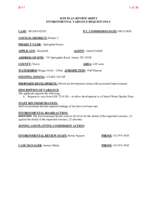
SITE PLAN REVIEW SHEET ENVIRONMENTAL VARIANCE REQUEST ONLY P.C. COMMISSION DATE: 08/11/2020 CASE: SP-2019-0253C COUNCIL DISTRICT: District 3 PROJECT NAME: Springdale Farms APPLICANT: Storybuilt ADDRESS OF SITE: 755 Springdale Road, Austin, TX 78702 COUNTY: Travis WATERSHED: Boggy Creek - Urban JURISDICTION: Full Purpose EXISTING ZONING: CS-MU-CO-NP PROPOSED DEVELOPMENT: Mixed use development along with associated improvements. DESCRIPTION OF VARIANCE: The applicant requests the following: AGENT: Jarred Corbell AREA: 4.85 acres 1. Request to vary from LDC 25-8-261 – to allow development in a Critical Water Quality Zone STAFF RECOMMENDATION: Staff recommends that the required findings of fact have not been met. ENVIRONMENTAL BOARD ACTION: 06/03/2020: The Environmental Board voted in (8) favor for the denial of the requested variance, (1) against the denial of the requested variance, (2) absentia. ZONING AND PLATTING COMMISSION ACTION: ENVIRONMENTAL REVIEW STAFF: Kristy Nguyen CASE MANAGER: Jeremy Siltala PHONE: 512-974-2945 PHONE: 512-974-3035 1 of 34B-11 ENVIRONMENTAL COMMISSION MOTION 20200603-006a Date: June 3, 2020 Subject: Springdale Farms, SP-2019-0253C Motion by: Kevin Ramberg Seconded by: Mary Ann Neely RATIONALE: WHEREAS, the Environmental Commission recognizes the applicant is requesting a variance from LDC 25- 8-261 to allow development in a critical water quality zone. WHEREAS, the Environmental Commission recognizes that staff does not recommend this variance, having determined that the findings of fact have not been met. THEREFORE, the Environmental Commission recommends denial of the requested variance from LDC 25- 8-261 to allow development in a critical water quality zone. VOTE 8-1 For: Smith, Neely, Coyne, Maceo, Ramberg, Guerrero, Gordon, and Bedford Against: Thompson Abstain: None Recuse: None Absent: Creel, Nill Approved By: Linda Guerrero, Environmental Commission Chair 1 2 of 34B-11 Staff Findings of Fact Variance to LDC 25-8-261 3 of 34B-11 Development Services Department Staff Recommendations Concerning Required Findings Project Name: Ordinance Standard: Watershed Protection Ordinance Variance Request: Springdale Farms SP-2019-0253C LDC 25-8-261 – to allow development in a Critical Water Quality Zone Include an explanation with each applicable finding of fact. A. Land Use Commission variance determinations from Chapter 25-8-41 of the City Code: 1. The requirement will deprive the applicant of a privilege available to owners of similarly situated property with approximately contemporaneous development subject to similar code requirements. No Approximately 3.2 acres of the 4.85 acre property are uplands and can be developed without the need for a variance from the Land Development Code. The Land Development Code does not provide an allowance for non-complying development within the CWQZ to maximize the amount of development that can occur on the property. 2. The variance: a) Is not necessitated by the scale, layout, construction method, or other design decision made by the applicant, unless the design decision provides greater overall environmental protection than is achievable without the variance; No Due to the scale of the project to maximize development, the applicant has made a design choice to make use of the CWQZ to address Austin Fire’s code requirement for the hammerheads, which are not allowed by the Land Development Code. Moreover, to increase building square footage, there will be building overhangs over the CWQZ, creating rain shadow effect that would deprive the CWQZ of necessary rainfall and sunlight. The scale and design decisions do not provide greater overall environmental protection. See Exhibit 1 – Overall Proposed Site Plan. b) Is the minimum deviation from the code requirement necessary to allow a reasonable use of the property; 4 of 34B-11 No c) No No No In addition to the building overhangs within the CWQZ, the hammerheads encroach on both sides of the CWQZ. Development is prohibited within the CWQZ except as provided in LDC 25-8-261 which doesn’t include the stated development, thus requiring the need for a variance from the Land Development Code. Does not create a significant probability of harmful environmental consequences. The building overhangs and hammerheads within the CWQZ would deprive the CWQZ of rainfall and sunlight penetration that are necessary for riparian health, and adding impervious cover and development to the CWQZ where there wouldn’t be otherwise. Furthermore, there would be removal of native vegetation and topsoil. 3. Development with the variance will result in water quality that is at least equal to the water quality achievable without the variance. No There would be impervious cover and development within the CWQZ where there wouldn’t be otherwise. The impervious cover from the building overhangs would not be draining to the water quality pond. B. The Land Use Commission may grant a variance from a requirement of Section 25-8-422 (Water Supply Suburban Water Quality Transition Zone), Section 25-8-452 (Water Supply Rural Water Quality Transition Zone), Section 25-8-482 (Barton Springs Zone Water Quality Transition Zone), Section 25-8-368 (Restrictions on Development Impacting Lake Austin, Lady Bird Lake, and Lake Walter E. Long), or Article 7, Division 1 ( Critical Water Quality Zone Restrictions ), after determining that:: 1. The criteria for granting a variance in Subsection (A) are met; Due to the design choice and scale of the project to maximize development, the CWQZ is utilized for development that is not allowed by the Land Development Code. The site contains uplands that are developable without the need for a variance from the Land Use Commission. 2. The requirement for which a variance is requested prevents a reasonable, economic use of the entire property; The uplands area has access on both sides of the CWQZ, thus providing the maximum allowance for development of a parcel of land with a CWQZ to occur without the need to vary from the Land Development Code and would not prevent a reasonable, economic use of the entire property. 3. The variance is the minimum deviation from the code requirement necessary to allow a reasonable, economic use of the entire property. No 3.2 acres of the 4.85 acre property are uplands and can be developed without the need for a variance from the Land Development 5 of 34B-11 Code. The Land Development Code does not provide an allowance for non-complying development within the CWQZ to increase the amount of development that can occur on the property. Staff Determination: Staff determines that the findings of fact have not been met. Environmental Reviewer (DSD) Environmental Review Manager (DSD) _____________________________ _____________________________ Date ________________ Date ________________ Environmental Officer (WPD) _____________________________ Chris Herrington, P.E. Date ________________ 5/05/2020 4/21/20 Mike McDougal4/21/20206 of 34B-11 Exhibit 1: Springdale Farms SP-2019-0253C – Overall Site Plan 7 of 34B-11 Applicant Form Variance to LDC 25-8-261 8 of 34B-11 February 15, 2020 City of Austin Real Estate 505 Barton Springs Rd Austin, TX 78704 Dear Sir or Madam- Re: Administrative Waiver Request, LDC 25-8-261, SP-2019-0253C Pursuant to Land Development Code, LDC 25-8-261, we respectfully request an administrative waiver to be allowed to use pervious pavers inside the CWQZ for fire department access, as well as cantilever over a portion of the CWQZ by about 4’. The proposed site is located at 755 Springdale Road. The site totals 4.85 acres located within the City’s Full Purpose Jurisdiction and Desired Development Zone, and located within an urban watershed, East Boggy Creek. The site is subject to Compatibility setbacks/restrictions along the entire north and south property lines. The property is to be developed with a mix of commercial space, a restaurant, and residential units. A tributary to Boggy Creek flows through the middle of the site separating it into an east and west half. The site is currently in review, SP-2019-0253C, with the City of Austin for a permit. The west half of the site is designed with a 1-story underground parking garage and the east half will have a 2-story underground parking garage. The highest elevation on site is 457, and the lowest is 446. The existing site currently has a restaurant, single-family home, and an extensive urban farm with sheds, coups, and equipment. The site is approximately 11% impervious but close to 80% disturbed area. The only connection between the two sides is an existing vehicular bridge that spans the creek. No CEFs were identified in the creek, and the drainage basin is approximately 70 acres resulting in a CWQZ setback, which is much larger than 50’ because of the flat nature of the property. A majority of the site is currently used as an active farm. This site appears large but there are several factors limiting the constructible space. 1/3 of the site is consumed by the CWQZ. The creek on site requires floodplain delineation, which extends well beyond the 50-ft offset for most creeks. Another 0.76ac is encumbered by Compatibility Setbacks on the entire north and south property line. Additionally, another 0.37ac of a grove of heritage trees (calculated only to half critical root zone), and that doesn’t include two other heritage trees outside of the grove, leaving a much smaller than normal portion of the lot to develop, and in a very inefficient shape. Even with this variance we will still only be able to develop to approximately half of our entitled impervious cover and less than 1/3 of our entitled FAR, which is certainly not inappropriate scale. We feel that this is a minor variance that allows the utmost and best design/use for the site, which is already very limited by a large bisecting CWQZ, a grove of heritage trees, various other heritage trees, PSW REAL ESTATE 900 S. 1ST STREET , Suite 110 AUSTIN, TX 78704 9 of 34B-11 and compatibility setbacks. Other properties don’t have these constraints, and this variance allows development that is still reduced to below 50% of entitlements by these factors. Furthermore, the area of CWQZ that will be encroached is currently developed and in use. The area under the proposed overhang is currently farmland, and will remain so regardless of the outcome of the variance. The areas proposed for pervious fire turn arounds are currently being used for a home/yard, and also for material and equipment storage. These areas will be used for farmland if the cannot be used for the turnaround. As per the reasons above, we request for a variance to differ from LDC 25-8-261. Please feel free to contact me with any questions. Sincerely, Casey Giles, P.E. Director of Engineering Casey.Giles@Storybuilt.com 512-294-3609 10 of 34B-11 April 28, 2020 ENVIRONMENTAL COMMISSION VARIANCE APPLICATION FORM PROJECT DESCRIPTION Applicant Contact Information Variance Case Information Name of Applicant Street Address City State ZIP Code Work Phone E-Mail Address Case Name Case Number Address or Location Environmental Reviewer Name Environmental Resource Management Reviewer Name Applicable Ordinance Watershed Name Watershed Classification Casey Giles 900 S 1st Street Austin, TX 78704 5122943609 Casey.giles@Storybuilt.com Springdale SP-2019-0253C 755 Springdale Rd, 78702 Kristy Nguyen LDC 25-8-261 E Boggy Creek ☐Urban ☐Water Supply Rural ☐ Suburban ☐Water Supply Suburban ☐ Barton Springs Zone City of Austin | Environmental Commission Variance Application Guide 1 11 of 34B-11 April 28, 2020 Edwards Aquifer Recharge Zone ☐ Barton Springs Segment ☐ Northern Edwards Segment ☐ Not in Edwards Aquifer Zones Edwards Aquifer Contributing Zone Distance to Nearest Classified Waterway Water and Waste Water service to be provided by ☐ Yes ☐ No Adjacent COA/AWU Request The variance request is as follows (Cite code references): We request a variance to LDC 25-8-261 to allow a portion of a fire lane and building overhang to be constructed in/above a critical water quality zone. Impervious cover square footage: acreage: percentage: Provide general description of the property (slope range, elevation range, summary of vegetation / trees, summary of the geology, CWQZ, WQTZ, CEFs, floodplain, heritage trees, any other notable or outstanding characteristics of the property) Existing 23,900 sf .55 ac 11 Proposed 105,600 sf 2.42 ac 50 The site totals 4.85 acres located within the City’s Full Purpose Jurisdiction and Desired Development Zone. The property is located within an urban watershed, East Boggy Creek. The site is subject to Compatibility setbacks/restrictions along the entire north and south property lines. The highest elevation on site is 457, and the lowest is 446. The existing site currently has a restaurant, single-family home, and an extensive urban farm with sheds, coups, and equipment. The site is approximately 11% impervious, and is divided in two parts by a tributary to Boggy Creek that flows diagonally from the south property line to the north property line. The only connection between the two sides is an existing vehicular bridge that spans the creek. No CEFs were identified in the creek, and the drainage basin is approximately 70 acres resulting in a CWQZ setback, which is much larger than 50’ because of the flat nature of the property. A majority of the site is used as an active farm. There are 12 large heritage trees on site. City of Austin | Environmental Commission Variance Application Guide 2 12 of 34B-11 April 28, 2020 Project: Ordinance: A. 1. Clearly indicate in what way the proposed project does not comply with current Code (include maps and exhibits) The end of the proposed fire lanes require a hammer head turn around, and this turn around is proposed in the CWQZ. It will be at grade, and composed of pervious grass-crete and fully revegetated. Also, the 2nd story of the building overhangs the CWQZ by approximately 4.5’ in a few isolated areas. See attached exhibits. FINDINGS OF FACT As required in LDC Section 25-8-41, in order to grant a variance the Land Use Commission must make the following findings of fact: Include an explanation with each applicable finding of fact. Land Use Commission variance determinations from Chapter 25-8-41 of the City Code: The requirement will deprive the applicant of a privilege available to owners of similarly situated property with approximately contemporaneous development subject to similar code requirements. Yes. The property is encumbered by the expanded CWQZ, a huge grove of heritage trees, and compatibility setbacks. In addition, the property is unique in that is spans the entire block from Springdale to Mansell, but is bordered on 2 sides by residential and bisected by a dry creek bed. The CWQZ is greatly expanded by undersized culverts downstream of the property and an incredibly flat channel slope of this man-made channel. Most (if any) properties in this area do not have the artificially expanded CWQZ nor do they have a trees of this size and number, and certainly not both. 2. The variance: a) Is not necessitated by the scale, layout, construction method, or other design decision made by the applicant, unless the design decision provides greater overall environmental protection than is achievable without the variance; Yes, 1/3 of the site is consumed by the CWQZ, another 0.76ac by Compatibility Setback, and another 0.37ac of a grove of heritage trees (only to half critical City of Austin | Environmental Commission Variance Application Guide 3 13 of 34B-11 April 28, 2020 3. 1. 2. root zone), and that doesn’t include two other heritage trees outside of the grove, leaving a much smaller than normal portion of the lot to develop, and in a very inefficient shape. Even with this variance we will still only be able to develop to approximately half of our entitled impervious cover and less than 1/3 of our entitled FAR, which is certainly not inappropriate scale. Is the minimum deviation from the code requirement necessary to allow a reasonable use of the property; Yes. Dozens of layouts, analysis, and iterations have been done. Does not create a significant probability of harmful environmental consequences. No, as mentioned above, the encroached area is limited, and currently being used for a home, a farm storage area, and a farmed area. Development with the variance will result in water quality that is at least equal to the water quality achievable without the variance. Yes. Runoff from all developed areas is captured. The fire lane will be pervious and fully revegetated, and the area under the small overhang is proposed to be used as urban farming whether there is any overhang or not, so it will be healthy, stable, and irrigated regardless. b) c) B. Additional Land Use Commission variance determinations for a requirement of Section 25-8-422 (Water Quality Transition Zone), Section 25-8-452 (Water Quality Transition Zone), Article 7, Division 1 (Critical Water Quality Zone Restrictions), or Section 25-8-652 (Development Impacting Lake Austin, Lady Bird Lake, and Lake Walter E. Long): The criteria for granting a variance in Subsection (A) are met; Yes. This is a minor variance that allows the utmost and best design/use for the site, which is already very limited by a large bisecting CWQZ, a grove of heritage trees, various other heritage trees, and compatibility setbacks. Other properties don’t have these constraints, and this variance allows development that is still reduced to below 50% of entitlements by these factors. Furthermore, the area of CWQZ that will be encroached is currently developed and in use. The requirement for which a variance is requested prevents a reasonable, economic use of the entire property; Yes, as mentioned above, we will still only be developing to about half of entitled impervious cover and less than 1/3 of the entitled FAR. City of Austin | Environmental Commission Variance Application Guide 4 14 of 34B-11 April 28, 2020 3. The variance is the minimum deviation from the code requirement necessary to allow a reasonable, economic use of the entire property. Yes, the encroachments are minimal impact, one of which is only a small overhang, the other of which will still be pervious and revegetated. **Variance approval requires all above affirmative findings. City of Austin | Environmental Commission Variance Application Guide 5 15 of 34B-11 April 28, 2020 A Exhibits for Commission Variance o Aerial photos of the site o Site photos o Aerial photos of the vicinity o Context Map—A map illustrating the subject property in relation to developments in the vicinity to include nearby major streets and waterways o Topographic Map - A topographic map is recommended if a significant grade change on the subject site exists or if there is a significant difference in grade in relation to adjacent properties. o For cut/fill variances, a plan sheet showing areas and depth of cut/fill with topographic elevations. o Site plan showing existing conditions if development exists currently on the property o Proposed Site Plan- full size electronic or at least legible 11x17 showing proposed development, include tree survey if required as part of site or subdivision plan o Environmental Map – A map that shows pertinent features including Floodplain, CWQZ, WQTZ, CEFs, Setbacks, Recharge Zone, etc. o An Environmental Resource Inventory pursuant to ECM 1.3.0 (if required by 25-8-121) o Applicant’s variance request letter City of Austin | Environmental Commission Variance Application Guide 6 16 of 34B-11 Applicant Exhibits 17 of 34B-11 Springdale Farms 06/03/2020 Environmental Variance Request 9/6/2019 18 of 34B-11 Site Location • • • • • Area: 4.85 acres Zoning: CS-MU-CO-NP Along Imagine Austin Corridor 2 Blocks from Transit priority (in both directions) Activity Corridor 19 of 34B-11 Neighborhood Outreach • Held community meetings to: • Understand from our future neighbors what the Farm has meant to the community • Get a sense of what future uses could be beneficial to • Introduce StoryBuilt and discuss overall design the community strategy the site) • Preservation (trees, existing features important to • Sustainability • Green infrastructure • Neighborhood fabric • Mixed Use (residential for sale and commercial) 20 of 34B-11 Community Feedback and Project Goals Feedback from community meetings: • Keep some level of farming and farm-stand operational • Mixed use (residential and commercial) • Open space • Independent grocery • Coffee shop/cafe • Welcoming environment • Pedestrian oriented • Sub-grade parking and limited Impervious cover • Affordable housing component – based on % of total Units built 21 of 34B-11 Site Plan Site Plan: • 87 For sale Units • • • • • • +/- 65,000 sf of commercial Open Space: 2.25 ac (includes 25k sf of Urban Farm 50% Imp cover (95% Allowed) FAR: 0.7:1 (2:1 Allowed) Tree Preservation Collaboration of StoryBuilt and the NPCT to accomplish the goals: • • • • Mixed Use Farming Sub-grade parking Pedestrian Oriented 22 of 34B-11 Proposed Encroachments Encroachment: • Approximately 3500 SF of “Grass- Crete” permeable paving system within Floodplain/CWQZ with only 1200 sf being within the initial 50- ft offset to serve as Fire access • Approximately 800 SF of building overhang into proposed urban farm area (max overhang: <5’) Fire Lane Fire Lane 50-ft CWQZ offset 23 of 34B-11 Site Overview and Hardship • • • • Total Area = 211,000 sf Buildable area = 108,000 or 50% of total area due to preserving 10 Heritage Trees, floodplain, CWQZ and compatibility setbacks CWQZ created due to basin being approximately 2 acres over 64 ac minimum even though channel is manmade Less than ½ % slope to Boggy Creek drastically increases floodplain and CWQZ 24 of 34B-11 Existing Conditions and Encroachments 25 of 34B-11 Existing Conditions and Encroachments Existing Greenhouse and Material storage Existing Farming Existing Home 26 of 34B-11 CWQZ Assessment Report Conclusions: • CWQZ and floodplain within the site are in Poor to Fair Condition • • The entirety of the CWQZ within the site has been historically disturbed Proposed Grassed pavers, Urban Farming and improving the drainage channel basin and upslopes per Environmental recommendations will improve overall Zones Floodplain CWQZ 27 of 34B-11 Summary of Proposed Encroachments Encroachment and Result: 1. Permeable grass pavers: Encroachment into CWQZ but outside 50-ft of channel Centerline. Replaces existing Greenhouse and material storage/equipment parking. If Not Granted: Loss of 4 Units 2. 3. Commercial Building Overhang of Urban Farm: Negligible impact to site, rain and sunlight non-factor as all season equinoxes provide ample sunlight and irrigation available. If Not Granted: Loss of 3,500sf of leasable space Permeable grass pavers: Encroachment into CWQZ with portion within 50-ft of channel Centerline. Replaces existing impervious cover/home. If Not Granted: Loss of 3 Units Fire Lane 1 2 3 Fire Lane 50-ft CWQZ offset 28 of 34B-11 Grass Crete Windsor Apartments, South Lamar 29 of 34B-11 7023 7022 5106 7019 7020 7018 7017 UE UE W L WL 7021 UE WL WL T RESTAURANT 2,168 SF BUILDING 7 FFE: 458.00 WL GL 10000 10009 10001 10002 7039 7015 10011 CO CO CO 10010 10006 10007 SSL SSL CO CO CO 10012 10008 10004 10005 7072 TL TL TL Bb Cb Bb Eb Eb 7073 PROP CONDOS UNIT B4(a)-6214 UNIT A1(a)-6114 742 SF PROP CONDOS UNIT B4-6213 UNIT A4-6113 742 SF PROP CONDO UNIT B3-6112 625 SF BUILDING 6 FFE: 455.00 L S S PROP CONDO UNIT A10-6111 492 SF 7026 PROP CONDO UNIT B3-6110 625 SF PROP CONDO UNIT A10-6109 492 SF PROP CONDO UNIT B3-6108 625 SF PROP CONDO UNIT A13(c)-6107 PROP CONDO UNIT A11-6106 491 SF 491 SF S S S S L L Cb G.T. WW WWL CO 8902 (H) 8901 (H) 6009 (H) PROP CONDOS UNIT B7(c)-6201 UNIT A3(c)-6101 625 SF PROP CONDOS UNIT A10-6202 UNIT S1-6102 500 SF L S S PROP CONDOS UNIT B7(b)-6203 UNIT A3(b)-6103 625 SF PROP CONDOS UNIT A16-6204 UNIT S1-6104 500 SF PROP CONDOS UNIT C2-6105 625 SF 5159 (H) 5160 (H) 5308 (H) 5312 WW SSL SSL WW 7075 (H) WL W WL W 6071 (H) WW WWL CO WWL WWL CO WW 7071 Bm Bm Bm Bm Bm Bm 7070 Bm Bm Bm Bm Bb Bm Bb Bb Bb Bb Bb Bb Bb Bb Bm Bm Bm Bm Bm Bm 6104 Bm Bm Bm S S S S L L RB 5161 (H) RB gm gm RB gm gm gm gm YP gm TL TL gm gm TL TL gm gm TL YP gm YP TL TL TL gm gm gm TL TL RB gm gm gm gm gm RB gm TL TL gm TL TL TL TL TL Bm Bm Bm Bm Bm Bm Bb Bm Bb Bb Bb Bb Bb Bb Bb Bb Bm Bm Bm Bm Bm Bm Bm Bm 6102 Bm Bm 6103 REF. CO G P CO SHEET L3 FM CO PROP CONDOS UNIT A12-2309 UNIT A6-2209 UNIT A7-2109 992 SF WWL WWL WW PROP CONDOS UNIT C1-2108 500 SF PROP CONDOS UNIT A15-2307 UNIT A8-2207 UNIT A9-2107 1,005 SF BUILDING 2 FFE: 452.50 PROP CONDO UNIT C1(a)-2106 500 SF L W W F M PROP CONDO UNIT A16(a)-2201 500 SF PROP CONDOS UNIT B7-2202 UNIT A3-2102 625 SF PROP CONDOS UNIT A16(b)-2203 UNIT S1(b)-2103 500 SF PROP CONDOS UNIT A15-2304 UNIT A8-2204 UNIT A9-2104 1,005 SF PROP CONDOS UNIT A16(a)-2205 UNIT S1(a)-2105 500 SF Bm Bm Bm Bm Bm TL Bm Bm TL Bm TL TL TL Bm Bm TL Bm TL TL Bm TL Bm E U T Bm Bm Dp Bm Dp Dp Dp Bm Bm Dp Dp Dp Dp Bm Bm Dp Dp Dp Dp Bm Dp Bm Dp Dp Dp TL TL TL Bm Dp Bm TL TL TL TL Bm TL TL Bm Bm Bm Bm Bm Bm Bm Bm Bm Bm Bm PROP CONDOS UNIT B9-4203 UNIT A5-4103 902 SF PROP CONDOS UNIT B6-4104 625 SF PROP CONDOS UNIT A15-4302 UNIT A8-4202 UNIT A9-4102 1,005 SF BUILDING 4 FFE: 452.50 PROP CONDOS UNIT A16(b)-4205 UNIT S1(b)-4105 500 SF PROP CONDOS UNIT C2-4106 625 SF PROP CONDOS UNIT A18-4301 UNIT B1-4201 UNIT B2-4101 1,016 SF WWL SSL WL PROP CONDO UNIT B5(a)-5101 631 SF PROP CONDOS UNIT B8-5202 UNIT A2-5102 618 SF PROP CONDOS UNIT A14-5203 UNIT A1-5103 524 SF PROP CONDOS UNIT B8-5204 UNIT A2-5104 618 SF BUILDING 5 FFE: 452.50 PROP CONDOS UNIT A14-5205 UNIT A1-5105 524 SF WW L S S L S S WW WL PROP CONDOS UNIT B7(a)-3208 UNIT SA3(a)-3108 625 SF PROP CONDOS UNIT A17-3207 UNIT S2-3107 625 SF PROP CONDOS UNIT B7-3206 UNIT A3-3106 625 SF PROP CONDO UNIT C2-3105 618 SF BUILDING 3 FFE: 452.50 PROP CONDOS UNIT A17(a)-3201 UNIT S2(a)-3101 625 SF PROP CONDOS UNIT B7-3202 UNIT A3-3102 625 SF PROP CONDOS UNIT A17-3203 UNIT S2-3103 625 SF PROP CONDOS UNIT B7(a)-3204 UNIT A3(a)-3104 625 SF L W GL L S S L W W WW SSL SSL SSL SSL WW SSL SSL WW L W PROP CONDO UNIT B5-1110 631 SF PROP CONDO UNIT B5-1109 631 SF PROP CONDO UNIT A13-1108 504 SF PROP CONDO UNIT B5-1107 631 SF PROP CONDO UNIT B5-1106 631 SF PROP CONDO UNIT A13-1105 504 SF PROP CONDO UNIT B5-1104 631 SF PROP CONDO UNIT B5-1103 631 SF PROP CONDO UNIT B5-1102 631 SF PROP CONDO UNIT A13(a)-1101 491 SF D D WL WL WL WL WL WL 5185 6135 7014 7013 7012 7009 7011 7008 7007 7006 7005 7004 BUILDING 1 FFE: 452.50 WL 7010 L S S PROP OFFICE/RETAIL 5,807.36 SF BUILDING 8 FFE: 455.00 REF. SHEET L2 S S L WW 5173 Vw Cb Cb Cb Cb Cb Cb 5172 5171 Cb 5170 Tc Tc 5169 5168 Tc Tc Tc Tc Tc Tc Cb Cb Cb Cb Cb Cb Cb Cb 6036 6037 IS IS IS IS IS 6038 IS IS IS IS Vw Vw Vw Vw Vw Vw Vw Vw Vw Vw 7032 Vw IS IS IS 5162 (H) 5167 5166 5165 5163 5164 In In In In In In In IS In IS IS IS IS IS IS IS IS IS IS IS In IS In In In In In In In F M 6137 Eb Eb Cb TL TL S S TL S S L L Cb W L CO 5302 5339 Bb Bb Bb 5338 WL 5336 5337 FM F M WL SSL WL C O C O C O C O CO CO L W L W L W L W 6008 (H) 6007 6006 (H) 6003 6004 6002 6001 I P V 6005 FDM PROP OFFICE/RETAIL 8,931.93 SF BUILDING 8 FFE: 455.00 DD D D WL L W L W E U E U WW WWL CO I R B F P WW FM CO 7025 CO 7033 FM FM 7028 FM WL FM WL FM 5342 7027 IS IS WL IS 7031 IS IS IS IS IS FM 7030 7029 UE UE T W L 2800 S. IH 35 FRONTAGE RD. SUITE 170 AUSTIN, TEXAS 78704 WWW.ECOLANDDESIGNGROUP.COM I 512-344-9204 i . s g n w a r d e s e h t o t t h g i r y p o c f o s t h g i r l l l a s d o h S E M O H W S P t u o h t i w r u c c o t o n y a m s t n e m u c o d r e h t o o t n i n o i t a r o p r o c n i r o e g a s u , s n o i t a c i f i d o m , n o i t a r e t l a , s n o i t c u d o r p e r y n A . S E M O H W S P f o n o i s s i m r e p n e t t i r w r o i r p e h t S E M O H W S P 5 1 0 2 © C L L S E M O H W S P 9 8 1 5 1 # M R I F E P B T . l m o c e t a t s e a e r w s p w w w . t e e r t S t s 1 S 3 0 0 2 4 0 7 8 7 X T , n i t s u A . 5 0 9 3 6 2 3 2 1 5 . . p . 5 7 1 8 6 6 8 8 8 8 . f . L D AD L RE STE EG I R R B CA EP A NDS E Y T.J A R C O N H I T E S E C T S T A 82 8 5 T E OF E T SA X 08/05/20 E L A D G N R P S I 2 0 7 8 7 X T , N I T S U A , . D R E L A D G N R P S I N A L P N O I T C U R T S N O C E T I S E P A C S D N A L N A L P L A T T I M B U S N O I T C U R T S N O C R O F T O N - W E I V E R R O F D E U S S I . x x x x x x 0 2 . E L T I T N O I S I V E R x 0 . V E R " 0 - ' 0 3 = " 1 : E L A C S B S C J T B : Y B D E K C E H C : Y B N W A R D E U E U E U T 7002 7003 L G L G L G L G 0 30' 60' 90' 120' ALL RESPONSIBILITY FOR THE ADEQUACY OF THESE PLANS REMAINS WITH THE ENGINEER WHO PREPARED THEM. IN APPROVING THESE PLANS, THE CITY OF AUSTIN MUST RELY UPON THE ADEQUACY OF THE WORK OF THE DESIGN ENGINEER. L G CAUTION: CONTRACTOR TO VERIFY ALL EXISTING UTILITIES VERTICALLY AND HORIZONTALLY PRIOR TO CONSTRUCTION. CONTRACTOR TO NOTIFY THE ENGINEER IMMEDIATELY OF ANY DISCREPANCIES. FOR CITY USE ONLY: L G SITE PLAN APPROVAL SHEET ________________ FILE NUMBER: APPLICATION DATE: APPROVED BY COMMISSION ON ________ UNDER SECTION 142 OF CHAPTER 25-5 OF THE CITY OF AUSTIN CODE. EXPIRATION DATE (25-5-81, LDC) __________CASE MANAGER: PROJECT EXPIRATION DATE (ORD.#970905) DWPZ ________ DDZ ____ __________________________________________________________________________ Director, Development Services Department RELEASED FOR GENERAL COMPLIANCE: _______ ZONING Rev. 1 ________________________Correction 1 _________________________________ Rev. 2 ________________________Correction 2 _________________________________ Rev. 3 ________________________Correction 3 _________________________________ FINAL PLAT MUST BE RECORDED BY THE PROJECT EXPIRATION DATE, IF APPLICABLE. SUBSEQUENT SITE PLANS WHICH DO NOT COMPLY WITH THE CODE CURRENT AT THE TIME OF FILING, AND ALL REQUIRED BUILDING PERMITS AND/OR NOTICE OF CONSTRUCTION (IF A BUILDING IS NOT REQUIRED), MUST ALSO BE APPROVED PRIOR TO THE PROJECT EXPIRATION DATE. S N O I S I V E R T E S X X X X W S P : R E B M U N T C E J O R P E L A D G N R P S I . D R E L A D G N R P S I 2 0 7 8 7 X T , n i t s u A : E M A N T C E J O R P PAGE NUMBER: CASE NUMBER: SP-2019-0253C SP-2019-0253C L1 of L5 30 of 34B-11 7022 5106 UE UE UE 7021 UE 7023 D R A Y T E E R T S WL 7019 7020 7018 7017 E U WL T RESTAURANT 2,168 SF BUILDING 7 FFE: 458.00 U E WL WL GL L W GL EXISTING TREE TO COUNT TOWARDS STREETYARD REQUIREMENTS, TYP. WL G.T. WW WWL W L W CO 8902 (H) S S 8901 (H) S 6009 (H) S D R A Y T E E R T S S 6007 ORNAMENTAL STREETYARD TREE, TYP. S 6008 (H) L W L W L W L W L W L W WW WWL CO WWL I R B F P S S . I N M ' 5 . I N M ' 5 . I N M ' 5 L W L W E U E U E U 6006 (H) DD D D PROP OFFICE/RETAIL 8,931.93 SF BUILDING 8 FFE: 455.00 6003 6004 6002 6001 I P V 6005 FDM GARAGE BELOW 5173 EXISTING TREE TO REMAIN, TYP. EXISTING TREE TO BE REMOVED, TYP. ALL DISTURBED CWQZ AREA WITHIN LOC TO BE RE-VEGETATED W/COA APPROVED 609S NATIVE SEED MIX, (+/- 70,512 S.F. OF AREA) REF. SHEET L5 & SERIES 600-609S IN CITY OF AUSTIN STANDARD SPECIFICATION MANUAL REQUIREMENTS FOR SEED ALL DISTURBED CWQZ AREA WITHIN LOC TO BE RE-VEGETATED W/ COA APPROVED 609S NATIVE SEED MIX AND SHOWN PLANTING. (+/- 70,512 S.F. OF AREA). REFERENCE SHEET L5 & SERIES 600-609S IN CITY OF AUSTIN STANDARD SPECIFICATION MANUAL REQUIREMENTS FOR SEED GARAGE BELOW 7039 7015 10000 10009 10001 10002 10011 CO CO CO 10012 10008 10004 2800 S. IH 35 FRONTAGE RD. SUITE 170 AUSTIN, TEXAS 78704 WWW.ECOLANDDESIGNGROUP.COM I 512-344-9204 10010 10006 10007 10005 7072 TREE LIST WL WL WL SSL SSL SSL SSL CO CO CO PROP CONDOS UNIT B4(a)-6214 UNIT A1(a)-6114 742 SF PROP CONDOS UNIT B4-6213 UNIT A4-6113 742 SF PROP CONDO UNIT B3-6112 625 SF PROP CONDO UNIT A10-6111 492 SF 7026 PROP CONDO UNIT B3-6110 625 SF PROP CONDO UNIT A10-6109 492 SF PROP CONDO UNIT B3-6108 625 SF PROP CONDO UNIT A13(c)-6107 PROP CONDO UNIT A11-6106 491 SF 491 SF BUILDING 6 FFE: 455.00 7075 (H) WL W PROP CONDOS UNIT B7(c)-6201 UNIT A3(c)-6101 625 SF PROP CONDOS UNIT A10-6202 UNIT S1-6102 500 SF PROP CONDOS UNIT B7(b)-6203 UNIT A3(b)-6103 625 SF PROP CONDOS UNIT A16-6204 UNIT S1-6104 500 SF PROP CONDOS UNIT C2-6105 625 SF 5308 (H) 5159 (H) 5160 (H) 5161 (H) L S S L S S L S S 5312 WL W WW SSL SSL SSL WW S S S S L L Cb S S S S L L RB S S S S L L TL TL TL Bb Cb Bb Eb Eb 7073 EXISTING TREE TO REMAIN, TYP. LOCATION OF REQUIRED 609S ROOTED PLANTS RIPARIAN ENHANCEMENT GARAGE BELOW RB gm gm RB gm gm gm gm YP gm TL gm gm TL TL gm gm TL YP gm YP TL TL TL gm gm gm TL TL RB gm gm gm gm gm RB gm TL TL gm TL TL TL TL TL RIPARIAN ENHANCEMENT AREA TL 3 L T E E H S . F E R E N I L H C T A M S S S S L L 6104 Bm Bm Bm Bm Bm Bm Bm Bm Bm Bb Bm Bb Bb Bb Bb Bb Bb Bb Bb Bm Bm Bm Bm Bm Bm Bm Bm 6102 Bm Bm 6103 WW WWL WWL CO WWL WWL WWL CO WW WL W 6071 (H) L S S L S S PROP OFFICE/RETAIL 5,807.36 SF BUILDING 8 FFE: 455.00 S S L GARAGE BELOW WW Vw Cb Cb Cb Cb Cb Cb 5172 5171 Cb 5170 Tc Tc 5169 5168 Cb Cb Cb Cb Cb Cb Cb Cb Tc Tc Tc Tc Tc Tc RIPARIAN ENHANCEMENT AREA In In In In In In In IS In IS IS IS IS IS IS 5162 (H) 5163 5164 5167 5166 5165 278-SF OF UNDISTURBED NATURAL AREA H LIN E R E F. S H E E T L 3 Eb Eb Cb F M F M 6137 F M WL SSL WL SSL C O C O C O IS IS IS IS IS In IS In In In In In In In 6036 6037 IS IS IS IS IS 6038 S S TL S S L L M A T C TL Cb S S S S L L W L TL FM 5339 Bb Bb Bb 5338 WL 5337 5336 FM W L FM CO 5302 C O CO CO LOCATION OF REQUIRED 609S ROOTED PLANTS ALL DISTURBED CWQZ AREA WITHIN LOC TO BE RE-VEGETATED W/ COA APPROVED 609S NATIVE SEED MIX AND SHOWN PLANTING. REFERENCE SHEET L5 & SERIES 600-609S IN CITY OF AUSTIN STANDARD SPECIFICATION MANUAL REQUIREMENTS FOR SEED FM CO PROP CONDOS UNIT A12-2309 UNIT A6-2209 UNIT A7-2109 992 SF F M F M PROP CONDO UNIT A16(a)-2201 500 SF PROP CONDOS UNIT B7-2202 UNIT A3-2102 625 SF WW SSL SSL SSL L S S PROP CONDO UNIT B5-1110 631 SF PROP CONDO UNIT B5-1109 631 SF PROP CONDO UNIT A13-1108 504 SF WL WL WL WL PROPOSED UTILITY COMPATIBLE STREETYARD TREE, TYP. W L WL WL WW FM CO 7025 CO FM 7033 FM FM 7028 FM UE UE T W L D R A UE Y T E E R T S 7027 IS IS IS IS Vw Vw Vw Vw Vw Vw Vw Vw Vw Vw Vw IS IS WL 7032 RIPARIAN IS ENHANCEMENT AREA WL IS IS WL IS 7031 IS IS IS IS IS FM FM 7030 7029 WL WL FM FM FM 5342 112 SF OF UNDISTURBED NATURAL AREA ALL DISTURBED CWQZ AREA WITHIN LOC TO BE RE-VEGETATED W/COA APPROVED 609S NATIVE SEED MIX, REF. SHEET L5 & SERIES 600-609S IN CITY OF AUSTIN STANDARD SPECIFICATION MANUAL REQUIREMENTS FOR SEED SHADE TREES SYMBOL COMMON NAME Texas Pistache SIZE AND CONDITION 6' Ht. min., 4" Caliper minimum Redbud, Forest Pansy 2" Caliper minimum DESCRIPTION 609s Facultative Species 609s Upland Species ORNAMENTAL TREES 609S NATIVE REVEGETATION - SEEDING & PLANTING 609S NATIVE REVEGETATION - ROOTED PLANTS NATIVE REVEGETATION - ROOTED PLANTS SYMBOL COMMON NAME SIZE AND CONDITION CALLOUT SYMBOL COMMON NAME SIZE AND CONDITION Required Provided Bb TL Cb American Beautyberry Elbow Bush 1 gal., 48" O.C. 1 gal., 72" O.C. Texas Lantana 1 gal., 48" O.C. Coralberry 1 gal., 36" O.C. Disturbed CWQZ Rooted Plants 3,852 sf / 100 sf = 39 Plants N/A sf 3,852 sf 39 plants 39 plants (5) 5 gal. plants = 20 plants (19) 1 gal. plants = 19 plants S = TREE TO COUNT TOWARDS STREETYARD SHRUBS M = TREE TO COUNT TOWARDS MITIGATION b = TREE TO COUNT TOWARDS BUFFER REQUIREMENTS REQUIREMENTS REQUIREMENTS SYMBOL COMMON NAME SIZE AND CONDITION Bicolor Iris 5 gal., 24" O.C. Dwarf Waxmyrtle 5 gal., 24" O.C. Big Muhly 5 gal., 24" O.C. 609S NATIVE REVEGETATION - ROOTED PLANTS SYMBOL COMMON NAME SIZE AND CONDITION Possumhaw Holly 5 gal. minimum Mexican Redbud 5 gal. minimum 5185 6135 GARAGE BELOW 7014 7013 0 20' 40' 60' 80' ALL RESPONSIBILITY FOR THE ADEQUACY OF THESE PLANS REMAINS WITH THE ENGINEER WHO PREPARED THEM. IN APPROVING THESE PLANS, THE CITY OF AUSTIN MUST RELY UPON THE ADEQUACY OF THE WORK OF THE DESIGN ENGINEER. CAUTION: CONTRACTOR TO VERIFY ALL EXISTING UTILITIES VERTICALLY AND HORIZONTALLY PRIOR TO CONSTRUCTION. CONTRACTOR TO NOTIFY THE ENGINEER IMMEDIATELY OF ANY DISCREPANCIES. FOR CITY USE ONLY: SITE PLAN APPROVAL SHEET ________________ FILE NUMBER: APPLICATION DATE: APPROVED BY COMMISSION ON ________ UNDER SECTION 142 OF CHAPTER 25-5 OF THE CITY OF AUSTIN CODE. EXPIRATION DATE (25-5-81, LDC) __________CASE MANAGER: PROJECT EXPIRATION DATE (ORD.#970905) DWPZ ________ DDZ ____ __________________________________________________________________________ Director, Development Services Department RELEASED FOR GENERAL COMPLIANCE: _______ ZONING Rev. 1 ________________________Correction 1 _________________________________ Rev. 2 ________________________Correction 2 _________________________________ Rev. 3 ________________________Correction 3 _________________________________ FINAL PLAT MUST BE RECORDED BY THE PROJECT EXPIRATION DATE, IF APPLICABLE. SUBSEQUENT SITE PLANS WHICH DO NOT COMPLY WITH THE CODE CURRENT AT THE TIME OF FILING, AND ALL REQUIRED BUILDING PERMITS AND/OR NOTICE OF CONSTRUCTION (IF A BUILDING IS NOT REQUIRED), MUST ALSO BE APPROVED PRIOR TO THE PROJECT EXPIRATION DATE. S N O I S I V E R T E S X X X X W S P : R E B M U N T C E J O R P E L A D G N R P S I . D R E L A D G N R P S I 2 0 7 8 7 X T , n i t s u A : E M A N T C E J O R P PAGE NUMBER: CASE NUMBER: SP-2019-0253C SP-2019-0253C L2 of L5 i . s g n w a r d e s e h t o t t h g i r y p o c f o s t h g i r l l l a s d o h S E M O H W S P t u o h t i w r u c c o t o n y a m s t n e m u c o d r e h t o o t n i n o i t a r o p r o c n i r o e g a s u , s n o i t a c i f i d o m , n o i t a r e t l a , s n o i t c u d o r p e r y n A . S E M O H W S P f o n o i s s i m r e p n e t t i r w r o i r p e h t S E M O H W S P 5 1 0 2 © C L L S E M O H W S P 9 8 1 5 1 # M R I F E P B T . l m o c e t a t s e a e r w s p w w w . t e e r t S t s 1 S 3 0 0 2 4 0 7 8 7 X T , n i t s u A . 5 0 9 3 6 2 3 2 1 5 . . p . 5 7 1 8 6 6 8 8 8 8 . f . L D AD L RE STE EG I R R B CA EP A NDS E Y T.J A R C O N H I T E S E C T S T A 82 8 5 T E OF E T SA X 08/05/20 E L A D G N R P S I 2 0 7 8 7 X T , N I T S U A , . D R E L A D G N R P S I N A L P N O I T C U R T S N O C E T I S E P A C S D N A L N A L P L A T T I M B U S N O I T C U R T S N O C R O F T O N - W E I V E R R O F D E U S S I . x x x x x x 0 2 . E L T I T N O I S I V E R x 0 . V E R " 0 - ' 0 2 = " 1 : E L A C S B S C J T B : Y B D E K C E H C : Y B N W A R D 31 of 34B-11 ALL DISTURBED CWQZ AREA WITHIN LOC TO BE RE-VEGETATED W/ COA APPROVED 609S NATIVE SEED MIX AND SHOWN PLANTING. (+/- 70,512 S.F. OF AREA). REFERENCE SHEET L5 & SERIES 600-609S IN CITY OF AUSTIN STANDARD SPECIFICATION MANUAL REQUIREMENTS FOR SEED 14,818 SF OF UNDISTURBED NATURAL AREA ALL DISTURBED CWQZ AREA WITHIN LOC TO BE RE-VEGETATED W/COA APPROVED 609S NATIVE SEED MIX, (+/- 70,512 S.F. OF AREA) REF. SHEET L5 & SERIES 600-609S IN CITY OF AUSTIN STANDARD SPECIFICATION MANUAL REQUIREMENTS FOR SEED 10002 10009 10011 CO CO CO SSL SSL SSL CO CO CO 10010 10006 10007 PROP CONDO UNIT A10-6109 492 SF PROP CONDO UNIT B3-6108 625 SF PROP CONDO UNIT A13(c)-6107 PROP CONDO UNIT A11-6106 491 SF 491 SF BUILDING 6 FFE: 455.00 S S S S L L Cb S S S S L L 10012 10008 10004 10005 7072 TL TL TL Bb Cb Bb Eb Eb 7073 7071 Bm Bm Bm Bm Bm Bm EXISTING TREE TO REMAIN, TYP. S S S S L L LOCATION OF REQUIRED 609S ROOTED PLANTS RIPARIAN ENHANCEMENT AREA 7070 Bm Bm Bm Bm Bb Bm Bb Bb Bb Bb S S S S L L Bb Bb Bb Bb Bm Bm Bm Bm Bm Bm 6104 Bm Bm Bm Bm Bm Bm Bm Bm Bm Bb Bm Bb Bb Bb Bb Bb Bb Bb Bb Bm Bm Bm Bm Bm Bm Bm Bm 6102 Bm Bm 6103 Bm Bm Bm Bm Bm TL Bm Bm TL Bm TL TL TL Bm Bm TL Bm TL TL Bm TL Bm S T R E E T Y A R D E U E U T S PROP CONDO UNIT B5(a)-5101 631 SF PROPOSED UTILITY COMPATIBLE STREETYARD TREE, TYP. GARAGE BELOW PROP CONDOS UNIT B8-5202 UNIT A2-5102 618 SF PROP CONDOS UNIT A14-5203 UNIT A1-5103 524 SF PROP CONDOS UNIT B8-5204 UNIT A2-5104 618 SF BUILDING 5 FFE: 452.50 PROP CONDOS UNIT A14-5205 UNIT A1-5105 524 SF S S S S RIPARIAN ENHANCEMENT AREA Bm Bm Dp Bm Dp Dp Dp Bm Bm Dp Dp Dp Dp Bm Bm Dp Dp Dp Dp Bm Dp Bm Dp Dp Dp TL TL TL Bm Dp Bm TL TL TL TL Bm TL TL Bm Bm Bm Bm Bm Bm Bm Bm Bm Bm Bm PROP CONDOS UNIT B9-4203 UNIT A5-4103 902 SF PROP CONDOS UNIT B6-4104 625 SF PROP CONDOS UNIT A15-4302 UNIT A8-4202 UNIT A9-4102 1,005 SF BUILDING 4 FFE: 452.50 PROP CONDOS UNIT A16(b)-4205 UNIT S1(b)-4105 500 SF PROP CONDOS UNIT C2-4106 625 SF PROP CONDOS UNIT A18-4301 UNIT B1-4201 UNIT B2-4101 1,016 SF L W W WW L S S L S S L S S L S S G P CO CO GARAGE BELOW WWL WWL WWL WWL WW SSL WL SSL WL WW WL FM CO PROP CONDOS UNIT A12-2309 UNIT A6-2209 UNIT A7-2109 992 SF F M PROP CONDOS UNIT C1-2108 500 SF PROP CONDOS UNIT A15-2307 UNIT A8-2207 UNIT A9-2107 1,005 SF BUILDING 2 FFE: 452.50 PROP CONDO UNIT C1(a)-2106 500 SF F M PROP CONDO UNIT A16(a)-2201 500 SF PROP CONDOS UNIT B7-2202 UNIT A3-2102 625 SF PROP CONDOS UNIT A16(b)-2203 UNIT S1(b)-2103 500 SF PROP CONDOS UNIT A15-2304 UNIT A8-2204 UNIT A9-2104 1,005 SF PROP CONDOS UNIT A16(a)-2205 UNIT S1(a)-2105 500 SF L W W L W W L W W PROP CONDOS UNIT B7(a)-3208 UNIT SA3(a)-3108 L S S 625 SF PROP CONDOS UNIT A17-3207 UNIT S2-3107 625 SF PROP CONDOS UNIT B7-3206 UNIT A3-3106 625 SF PROP CONDO UNIT C2-3105 618 SF BUILDING 3 FFE: 452.50 L S S PROP CONDOS UNIT A17(a)-3201 UNIT S2(a)-3101 625 SF PROP CONDOS UNIT B7-3202 UNIT A3-3102 625 SF PROP CONDOS UNIT A17-3203 UNIT S2-3103 625 SF PROP CONDOS UNIT B7(a)-3204 UNIT A3(a)-3104 625 SF GARAGE BELOW GL WW SSL SSL SSL SSL SSL SSL WW SSL SSL SSL L S S PROP CONDO UNIT B5-1110 631 SF PROP CONDO UNIT B5-1109 631 SF PROP CONDO UNIT A13-1108 504 SF PROP CONDO UNIT B5-1107 631 SF PROP CONDO UNIT B5-1106 631 SF PROP CONDO UNIT A13-1105 504 SF PROP CONDO UNIT B5-1104 631 SF PROP CONDO UNIT B5-1103 631 SF PROP CONDO UNIT B5-1102 631 SF PROP CONDO UNIT A13(a)-1101 491 SF WL WL WL WL WL WL WL WL WL WL WL EXISTING TREE TO BE REMOVED, TYP. L G E U E U E U GL E U T 7002 7003 WL S T R E E T Y A R D L W S E U L W L W L W S T R E E T WW Y A R D D D S T R E E T Y A R D BUILDING 1 FFE: 452.50 7010 7009 7011 C O CO CO LOCATION OF REQUIRED 609S ROOTED PLANTS 5185 6135 7014 7013 7012 GARAGE BELOW 7008 7007 7006 7005 7004 L G L G L G L G PROP CONDOS UNIT A16-6204 UNIT S1-6104 500 SF PROP CONDOS UNIT C2-6105 625 SF 5159 (H) 5160 (H) 5161 (H) SSL WW WW gm RB 2 L T E E H YP S gm gm RB gm gm gm RB gm gm gm TL TL TL gm TL TL TL TL GARAGE BELOW gm . TL TL F YP E R E N I L H C T A M YP gm gm gm gm TL RB gm TL TL gm TL TL RB gm gm gm gm gm TL TL TL RIPARIAN ENHANCEMENT AREA 5162 (H) 5163 5164 5167 5166 5165 278-SF OF UNDISTURBED NATURAL AREA In In In In In In In H LIN E R E F. S H E E T L 2 Eb IS In IS IS IS IS IS IS IS IS IS IS In M A T C S S S S L L Eb Cb TL TL TL Cb S S S S L L W L FM 5339 Bb Bb Bb 5338 WL 5337 5336 FM W L FM CO 5302 F M F M 6137 F M WL SSL WL SSL C O C O C O ALL DISTURBED CWQZ AREA WITHIN LOC TO BE RE-VEGETATED W/ COA APPROVED 609S NATIVE SEED MIX AND SHOWN PLANTING. REFERENCE SHEET L5 & SERIES 600-609S IN CITY OF AUSTIN STANDARD SPECIFICATION MANUAL REQUIREMENTS FOR SEED SHADE TREES SYMBOL COMMON NAME Texas Pistache SIZE AND CONDITION 6' Ht. min., 4" Caliper minimum Redbud, Forest Pansy 2" Caliper minimum DESCRIPTION 609s Facultative Species 609s Upland Species ORNAMENTAL TREES 609S NATIVE REVEGETATION - SEEDING & PLANTING 609S NATIVE REVEGETATION - ROOTED PLANTS NATIVE REVEGETATION - ROOTED PLANTS SYMBOL COMMON NAME SIZE AND CONDITION CALLOUT SYMBOL COMMON NAME SIZE AND CONDITION Required Provided Bb TL Cb American Beautyberry Elbow Bush 1 gal., 48" O.C. 1 gal., 72" O.C. Texas Lantana 1 gal., 48" O.C. Coralberry 1 gal., 36" O.C. Disturbed CWQZ Rooted Plants 3,852 sf / 100 sf = 39 Plants N/A sf 3,852 sf 39 plants 39 plants (5) 5 gal. plants = 20 plants (19) 1 gal. plants = 19 plants S = TREE TO COUNT TOWARDS STREETYARD SHRUBS M = TREE TO COUNT TOWARDS MITIGATION b = TREE TO COUNT TOWARDS BUFFER REQUIREMENTS REQUIREMENTS REQUIREMENTS SYMBOL COMMON NAME SIZE AND CONDITION Bicolor Iris 5 gal., 24" O.C. Dwarf Waxmyrtle 5 gal., 24" O.C. Big Muhly 5 gal., 24" O.C. 609S NATIVE REVEGETATION - ROOTED PLANTS SYMBOL COMMON NAME SIZE AND CONDITION Possumhaw Holly 5 gal. minimum Mexican Redbud 5 gal. minimum 2800 S. IH 35 FRONTAGE RD. SUITE 170 AUSTIN, TEXAS 78704 WWW.ECOLANDDESIGNGROUP.COM I 512-344-9204 TREE LIST i . s g n w a r d e s e h t o t t h g i r y p o c f o s t h g i r l l l a s d o h S E M O H W S P t u o h t i w r u c c o t o n y a m s t n e m u c o d r e h t o o t n i n o i t a r o p r o c n i r o e g a s u , s n o i t a c i f i d o m , n o i t a r e t l a , s n o i t c u d o r p e r y n A . S E M O H W S P f o n o i s s i m r e p n e t t i r w r o i r p e h t S E M O H W S P 5 1 0 2 © C L L S E M O H W S P 9 8 1 5 1 # M R I F E P B T . l m o c e t a t s e a e r w s p w w w . t e e r t S t s 1 S 3 0 0 2 4 0 7 8 7 X T , n i t s u A . 5 0 9 3 6 2 3 2 1 5 . . p . 5 7 1 8 6 6 8 8 8 8 . f . L D AD L RE STE EG I R R B CA EP A NDS E Y T.J A R C O N H I T E S E C T S T A 82 8 5 T E OF E T SA X 08/05/20 E L A D G N R P S I 2 0 7 8 7 X T , N I T S U A , . D R E L A D G N R P S I N A L P N O I T C U R T S N O C E T I S E P A C S D N A L N A L P L A T T I M B U S N O I T C U R T S N O C R O F T O N - W E I V E R R O F D E U S S I . x x x x x x 0 2 . E L T I T N O I S I V E R x 0 . V E R " 0 - ' 0 2 = " 1 : E L A C S B S C J T B : Y B D E K C E H C : Y B N W A R D 0 20' 40' 60' 80' ALL RESPONSIBILITY FOR THE ADEQUACY OF THESE PLANS REMAINS WITH THE ENGINEER WHO PREPARED THEM. IN APPROVING THESE PLANS, THE CITY OF AUSTIN MUST RELY UPON THE ADEQUACY OF THE WORK OF THE DESIGN ENGINEER. CAUTION: CONTRACTOR TO VERIFY ALL EXISTING UTILITIES VERTICALLY AND HORIZONTALLY PRIOR TO CONSTRUCTION. CONTRACTOR TO NOTIFY THE ENGINEER IMMEDIATELY OF ANY DISCREPANCIES. FOR CITY USE ONLY: SITE PLAN APPROVAL SHEET ________________ FILE NUMBER: APPLICATION DATE: APPROVED BY COMMISSION ON ________ UNDER SECTION 142 OF CHAPTER 25-5 OF THE CITY OF AUSTIN CODE. EXPIRATION DATE (25-5-81, LDC) __________CASE MANAGER: PROJECT EXPIRATION DATE (ORD.#970905) DWPZ ________ DDZ ____ __________________________________________________________________________ Director, Development Services Department RELEASED FOR GENERAL COMPLIANCE: _______ ZONING Rev. 1 ________________________Correction 1 _________________________________ Rev. 2 ________________________Correction 2 _________________________________ Rev. 3 ________________________Correction 3 _________________________________ FINAL PLAT MUST BE RECORDED BY THE PROJECT EXPIRATION DATE, IF APPLICABLE. SUBSEQUENT SITE PLANS WHICH DO NOT COMPLY WITH THE CODE CURRENT AT THE TIME OF FILING, AND ALL REQUIRED BUILDING PERMITS AND/OR NOTICE OF CONSTRUCTION (IF A BUILDING IS NOT REQUIRED), MUST ALSO BE APPROVED PRIOR TO THE PROJECT EXPIRATION DATE. S N O I S I V E R T E S X X X X W S P : R E B M U N T C E J O R P E L A D G N R P S I . D R E L A D G N R P S I 2 0 7 8 7 X T , n i t s u A : E M A N T C E J O R P PAGE NUMBER: CASE NUMBER: SP-2019-0253C SP-2019-0253C L3 of L5 32 of 34B-11 TREE LIST LANDSCAPE CALCULATIONS STREET YARD (Springdale) Required Provided Total Site Area N/A Total Street Yard Area N/A Street-yard / Landscape ( 20%) 2,890 sf sf (43% ) TREES (street yard) 211,300 sf sf 14,450 6,194 Required Provided 12 12 Existing Tree Credit: (4) trees 6"< = 8 street trees Proposed Tree Credit: (4) street trees STREET YARD (Mansell) Required Provided Total Site Area N/A 6,325 Total Street Yard Area N/A 2,910 Street-yard / Landscape ( 20%) 1,265 sf sf (46% ) TREES (street yard) 211,300 sf sf Required Provided 6 6 Existing Tree Credit: (0) trees 6"< = 0 street trees Required Provided BUFFERING Small preferred tree: 0 x 3 = 0 pts Lg. preferred shrub: 10 x 6 = 60 pts 30 pts. 60 pts. REPLACEMENT TREES Total caliper inches to be replaced: Total caliper inches replaced: Existing caliper inches preserved under 8" to count towards mitigation- 0 Trees totaling 0" Split Credit Canopy Trees: 8 x 2.5" = 20" Split Credit Ornamental Trees: 2 x .5" = 1" 250.75" X 200 = $50,150 POTENTIAL PAYMENT TO TREE CARE PLAN: POTENTIAL PAYMENT TO 'PLANTING FOR THE FUTURE FUND': 184" X 200 = $36,800 455.75" 21" 250.75" 184" ISLANDS, MEDIANS, OR PENINSULAS Required Provided Street Yard Area -0 spots x 7.5 s.f. = 0 s.f. Non-Street Yard Area -0 spots x 5 s.f. = 0 s.f. N/A sf 0 sf 0 sf 0 sf Required Landscape Area: 4,202 + 0 = 4,202 S.F. 50% of Required Landscape Area: 4,202 S.F. / 2 = 2,101 S.F. Required Provided Landscape Areas Receiving Storm Water Run-off: Natural Areas: Undisturbed Existing Trees: sf 0 0 0 sf 0 sf 0 14,818 sf sf sf TOTAL: 2,101 sf 14,818 sf Notes: Reference Plan for Areas Calculated on this Chart URBAN FORESTRY SUMMARY Total Appendix F Trees inches Surveyed Total Appendix F Tree Inches Removed: PRIVATE Total Appendix F Tree Inches Removed: ROW Total Non-Appendix F Tree Inches Removed: PRIVATE Total Non-Appendix F Tree Inches Removed: ROW Total Invasive Tree Inches Removed: PRIVATE Total Invasive Tree Inches Removed: ROW Total Mitigation Inches Planted on Site Total Dead Inches Removed Total Non-Mitigation Inches Planted on Site 1,443" 326.5" 295" 0" 40" 19" 63.5" 21" 30" 15" LANDSCAPE CONSTRUCTION NOTES 1. It is the responsibility of the landscape contractor to confirm all materials quantities from the plans. All quantities shown on the schedule are for contractor's convenience only. 2. No substitutions on size or spacing of plants on this plan can be made without the approval of Landscape Architect or owner. 3. The contractor is responsible for verifying all existing utilities on site. Any damage to existing or proposed utilities is to be repaired according to local standards and at the landscape contractor's expense. Coordinate all construction with the appropriate utility companies. 4. All planting beds to receive dark hardwood mulch. Mulch to be installed at 3” unless otherwise indicated. 5. Dimensions used for height, spread and truck specification on the plant material list are a general guide for the minimal size of plant. 6. All disturbed areas are to be re-vegetated with Tifway 419 per drawings and specifications. 7. No excavation or planting pit shall be left open overnight. 8. Positive drainage is to be provided around all building foundations. 9. The landscape contractor shall obtain any necessary permits, licensees, etc. and shall give notices and comply with all applicable laws, ordinances, codes, rules and regulations during the course of the project. 10. All plant material to be nursery grown and to comply with the American standard for nursery stock for size and quality. 11. The landscape architect / client reserves the right to refuse any plant material or any defective workmanship. Contractor to keep all plant material tags for inspection. minimum caliper height and spread of the side branches as shown on the plant list. Trunk shall be undamaged and shape shall be typical of the species. 13. The landscape contractor shall be responsible for the staking and layout of all planting on this project. 14. Should the landscape contractor encounter unsatisfactory surface or subsurface drainage conditions, soil depth, hard pan, stems, utility lines, or other conditions that may compromise the health and vigor of the plants, they must advise the landscape architect in writing the conditions prior to installing plants. Otherwise the landscape contractor warrants that the planting areas are suitable for proper growth and development of the plants to be installed. 15. Existing trees are to be protected and barricaded if necessary for the proposed landscape improvements. The landscape contractor assumes full responsibility for any tree damage caused directly by his scope of work. 2800 S. IH 35 FRONTAGE RD. SUITE 170 AUSTIN, TEXAS 78704 WWW.ECOLANDDESIGNGROUP.COM I 512-344-9204 APPENDIX O - LANDSCAPE / IRRIGATION NOTES SITE DEVELOPMENT PERMIT - IRRIGATION NOTES Automatic irrigation systems shall comply with TCEQ Chapter 344, as well as the following requirements: 1. These requirements shall be noted on the Site Development Permit and shall be implemented as part of the landscape inspection: a. the system must provide a moisture level adequate to sustain growth of the plant materials; b. the system does not include spray irrigation on areas less than ten (10) feet wide (such as medians, buffer strips, and parking lot islands); c. circuit remote control valves have adjustable flow controls; d. serviceable in-head check valves area adjacent to paved areas where elevation differences may cause low head drainage; e. a master valve installed on the discharge side of the backflow preventer; f. above-ground irrigation emission devices are set back at least six (6) inches from impervious surfaces; g. an automatic rain shut-off device shuts off the irrigation system automatically after more than a one-half inch (½") rainfall; and h. newly planted trees shall have permanent irrigation consisting of drip or bubblers. 2. The irrigation installer shall develop and provide an as-built design plan to the City at the time the final irrigation inspection is performed; a. unless fiscal security is provided to the City for the installation of the system, it must be operational at the time of the final landscape inspection. 3. The irrigation installer shall also provide exhibits to be permanently installed inside or attached to the irrigation controller, including: a. a laminated copy of the water budget containing zone numbers, precipitation rate, and gallons per minute; and a zone map with the isolation valve location. 4. The irrigation installer shall provide a report to the City on a form provided by Austin Water certifying compliance with Subsection 1. When the final plumbing inspection is performed by the City. SUBCHAPTER C:INNOVATIVE WATER MANAGEMENT 12. All plant material shall have a well formed head with i . s g n w a r d e s e h t o t t h g i r y p o c f o s t h g i r l l l a s d o h S E M O H W S P t u o h t i w r u c c o t o n y a m s t n e m u c o d r e h t o o t n i n o i t a r o p r o c n i r o e g a s u , s n o i t a c i f i d o m , n o i t a r e t l a , s n o i t c u d o r p e r y n A . S E M O H W S P f o n o i s s i m r e p n e t t i r w r o i r p e h t S E M O H W S P 5 1 0 2 © C L L S E M O H W S P 9 8 1 5 1 # M R I F E P B T . l m o c e t a t s e a e r w s p w w w . t e e r t S t s 1 S 3 0 0 2 4 0 7 8 7 X T , n i t s u A . 5 0 9 3 6 2 3 2 1 5 . . p . 5 7 1 8 6 6 8 8 8 8 . f . L D AD L RE STE EG I R R B CA EP A NDS E Y T.J A R C O N H I T E S E C T S T A 82 8 5 T E OF E T SA X 08/05/20 E L A D G N R P S I 2 0 7 8 7 X T , N I T S U A , . D R E L A D G N R P S I S L I A T E D & S E T O N E P A C S D N A L N A L P L A T T I M B U S N O I T C U R T S N O C R O F T O N - W E I V E R R O F D E U S S I . x x x x x x 0 2 . E L T I T N O I S I V E R x 0 . V E R TREE REPLACEMENT CALCULATIONS R.O.W. TREE REPLACEMENT CALCULATIONS Not on App. F 8-18.9" On App. F 19" + Not on App. F 19" + Heritage Tree 24" + Tree Number To Be Removed On App. F 8-18.9" Not on App. F 8-18.9" On App. F 19" + Not on App. F 19" + Tree Number To Be Removed On App. F 8-18.9" 161.5" REF. TREE LIST Totals INCHES TO BE REPLACED 161.5" 50% 80.75" 0" 25% N/A 107" 107" 100% 107" 0" 50% N/A 28" 28" 300% 84" REF. TREE LISTS Totals INCHES TO BE REPLACED 256" 256" 50% 128" 12" 12" 25% 3" 39" 39" 100% 39" TOTAL CALIPER INCHES TO BE REPLACED TOTAL CALIPER INCHES REPLACED ON SITE EXISTING CALIPER INCHES PRESERVED UNDER 8" (0 TREES) TOTAL CALIPER INCHES TO BE PAID INTO TREE CARE PLAN -250.75" X $200 = $50,150 TO BE PAID INTO TREE CARE PLAN 271.75" 21" 0" 250.75" TOTAL CALIPER INCHES TO BE REPLACED TOTAL CALIPER INCHES REPLACED IN ROW TOTAL CALIPER INCHES TO BE PAID INTO THE 'URBAN FOREST REPLENISHMENT FUND -184" X $200 = $36,800 ALL RESPONSIBILITY FOR THE ADEQUACY OF THESE PLANS REMAINS WITH THE ENGINEER WHO PREPARED THEM. IN APPROVING THESE PLANS, THE CITY OF AUSTIN MUST RELY UPON THE ADEQUACY OF THE WORK OF THE DESIGN ENGINEER. CAUTION: CONTRACTOR TO VERIFY ALL EXISTING UTILITIES VERTICALLY AND HORIZONTALLY PRIOR TO CONSTRUCTION. CONTRACTOR TO NOTIFY THE ENGINEER IMMEDIATELY OF ANY DISCREPANCIES. 28" 28" 50% 14" 184" 0" 184" FOR CITY USE ONLY: SITE PLAN APPROVAL SHEET ________________ FILE NUMBER: APPLICATION DATE: APPROVED BY COMMISSION ON ________ UNDER SECTION 142 OF CHAPTER 25-5 OF THE CITY OF AUSTIN CODE. EXPIRATION DATE (25-5-81, LDC) __________CASE MANAGER: PROJECT EXPIRATION DATE (ORD.#970905) DWPZ ________ DDZ ____ __________________________________________________________________________ Director, Development Services Department RELEASED FOR GENERAL COMPLIANCE: _______ ZONING Rev. 1 ________________________Correction 1 _________________________________ Rev. 2 ________________________Correction 2 _________________________________ Rev. 3 ________________________Correction 3 _________________________________ FINAL PLAT MUST BE RECORDED BY THE PROJECT EXPIRATION DATE, IF APPLICABLE. SUBSEQUENT SITE PLANS WHICH DO NOT COMPLY WITH THE CODE CURRENT AT THE TIME OF FILING, AND ALL REQUIRED BUILDING PERMITS AND/OR NOTICE OF CONSTRUCTION (IF A BUILDING IS NOT REQUIRED), MUST ALSO BE APPROVED PRIOR TO THE PROJECT EXPIRATION DATE. CASE NUMBER: SP-2019-0253C SP-2019-0253C E L A D G N R P S I . D R E L A D G N R P S I 2 0 7 8 7 X T , n i t s u A : E M A N T C E J O R P PAGE NUMBER: N W O H S S A : E L A C S B S C J T B : Y B D E K C E H C : Y B N W A R D L4 of L5 S N O I S I V E R T E S X X X X W S P : R E B M U N T C E J O R P 33 of 34B-11 SHADE TREES SYMBOL QUANTITY COMMON NAME SCIENTIFIC NAME 8 Texas Pistache Pistacia texana SIZE AND CONDITION 6' Ht. min., 4" Caliper minimum ORNAMENTAL TREES SYMBOL QUANTITY COMMON NAME 2 Redbud, Forest Pansy SHRUBS SCIENTIFIC NAME Cercis canadensis ' Forest pansy ' SIZE AND CONDITION 2" Caliper minimum SYMBOL QUANTITY COMMON NAME SCIENTIFIC NAME SIZE AND CONDITION 10 Dwarf Waxmyrtle Bicolor Iris Big Muhly Dietes bicolor Myrica cerifera var. pumila Muhlenbergia lindheimeri 5 gal., 24" O.C. 5 gal., 24" O.C. 5 gal., 24" O.C. RIPARIAN ENHANCEMENT PLANT SCHEDULE QUANTITY SYMBOL COMMON NAME SCIENTIFIC NAME SIZE AND CONDTION YP Yaupon Holly Ilex vomitoria 1" caliper minimum RB Texas Redbud 1" caliper minimum Inland seaoats Indian Grass Turks Cap Coralberry American Beautyberry Gulf Muhly IS In Tc Cb Vw Bb gm Dp TL Cercis canadensis var. texensis Hasmanthium latifolium Sorghastrum nutans Malvaviscus drummondii Symphoricarpos orbiculatus Elymus virginicus Callicarpa americana Muhlenbergia capillaris Lantana urticoides Muhlenbergia lindheimeri Dwarf Palmetto Sabal minor 1 gallon minimum Texas Lantana 1 gallon minimum Bm Big Muhly 1 gallon minimum 1 gallon minimum 1 gallon minimum 1 gallon minimum 1 gallon minimum 1 gallon minimum 1 gallon minimum Virginia wildrye 1 gallon minimum 3 5 33 16 8 15 12 18 22 17 35 73 SYMBOL QUANTITY COMMON NAME SCIENTIFIC NAME SIZE AND CONDITION 9. The landscape contractor shall obtain any necessary permits, 609S NATIVE REVEGETATION - SEEDING & PLANTING QUANTITY CALLOUT DESCRIPTION 609s Facultative Species: Indian Blanket (10 lbs / acre) Sunflower (5 lbs / acre). Provide 6" of additional topsoil in this area. Hydromulch with tackifier additive agent. Seed mix available from seedsource.com. Temp-irrigation all areas until established. 609s Upland Species: Buffalograss (21 lbs / acre) Blue Gramma (10 bs / acre) Sideoats Gama (7 lbs / acre) and Canada Wild Rye (10 lbs / acre). Provide 6" of additional topsoil in this area. Hydromulch with tackifier additive agent. Seed mix available from seedsource.com. Temp-irrigation all areas until established. 609S NATIVE REVEGETATION - ROOTED PLANTS Possumhaw Holly Ilex decidua Mexican Redbud Cercis canadensis var. mexicana 5 gal. minimum 5 gal. minimum 609S NATIVE REVEGETATION - ROOTED PLANTS SYMBOL QUANTITY SCIENTIFIC NAME SIZE AND CONDITION COMMON NAME American Beautyberry Callicarpa americana 1 gal., 48" O.C. Elbow Bush Forestiera pubescens 1 gal., 72" O.C. Texas Lantana Lantana urticoides 1 gal., 48" O.C. Coralberry Symphoricarpos orbiculatus 1 gal., 36" O.C. 3 2 5 4 6 4 57 lbs 17 lbs Bb TL Cb NATIVE REVEGETATION - ROOTED PLANTS Required Provided Disturbed CWQZ Rooted Plants 3,852 sf / 100 sf = 39 Plants (5) 5 gal. plants = 20 plants (19) 1 gal. plants = 19 plants N/A sf 3,852 sf 39 plants 39 plants LANDSCAPE CONSTRUCTION NOTES 1. It is the responsibility of the landscape contractor to confirm all materials quantities from the plans. All quantities shown on the schedule are for contractor's convenience only. 2. No substitutions on size or spacing of plants on this plan can be made without the approval of Landscape Architect or owner. 3. The contractor is responsible for verifying all existing utilities on site. Any damage to existing or proposed utilities is to be repaired according to local standards and at the landscape contractor's expense. Coordinate all construction with the appropriate utility companies. 4. All planting beds to receive dark hardwood mulch. Mulch to be installed at 3” unless otherwise indicated. 5. Dimensions used for height, spread and truck specification on the plant material list are a general guide for the minimal size of plant. 6. All disturbed areas are to be re-vegetated with Tifway 419 per drawings and specifications. 7. No excavation or planting pit shall be left open overnight. 8. Positive drainage is to be provided around all building foundations. licensees, etc. and shall give notices and comply with all applicable laws, ordinances, codes, rules and regulations during the course of the project. 10. All plant material to be nursery grown and to comply with the American standard for nursery stock for size and quality. 11. The landscape architect / client reserves the right to refuse any plant material or any defective workmanship. Contractor to keep all plant material tags for inspection. 12. All plant material shall have a well formed head with minimum caliper height and spread of the side branches as shown on the plant list. Trunk shall be undamaged and shape shall be typical of the species. 13. The landscape contractor shall be responsible for the staking and layout of all planting on this project. 14. Should the landscape contractor encounter unsatisfactory surface or subsurface drainage conditions, soil depth, hard pan, stems, utility lines, or other conditions that may compromise the health and vigor of the plants, they must advise the landscape architect in writing the conditions prior to installing plants. Otherwise the landscape contractor warrants that the planting areas are suitable for proper growth and development of the plants to be installed. 15. Existing trees are to be protected and barricaded if necessary for the proposed landscape improvements. The landscape contractor assumes full responsibility for any tree damage caused directly by his scope of work. 2800 S. IH 35 FRONTAGE RD. SUITE 170 AUSTIN, TEXAS 78704 WWW.ECOLANDDESIGNGROUP.COM I 512-344-9204 APPENDIX O - LANDSCAPE / IRRIGATION NOTES SITE DEVELOPMENT PERMIT - IRRIGATION NOTES Automatic irrigation systems shall comply with TCEQ Chapter 344, as well as the following requirements: 1. These requirements shall be noted on the Site Development Permit and shall be implemented as part of the landscape inspection: a. the system must provide a moisture level adequate to sustain growth of the plant materials; b. the system does not include spray irrigation on areas less than ten (10) feet wide (such as medians, buffer strips, and parking lot islands); c. circuit remote control valves have adjustable flow controls; d. serviceable in-head check valves area adjacent to paved areas where elevation differences may cause low head drainage; e. a master valve installed on the discharge side of the backflow preventer; f. above-ground irrigation emission devices are set back at least six (6) inches from impervious surfaces; g. an automatic rain shut-off device shuts off the irrigation system automatically after more than a one-half inch (½") rainfall; and h. newly planted trees shall have permanent irrigation consisting of drip or bubblers. 2. The irrigation installer shall develop and provide an as-built design plan to the City at the time the final irrigation inspection is performed; a. unless fiscal security is provided to the City for the installation of the system, it must be operational at the time of the final landscape inspection. 3. The irrigation installer shall also provide exhibits to be permanently installed inside or attached to the irrigation controller, including: a. a laminated copy of the water budget containing zone numbers, precipitation rate, and gallons per minute; and a zone map with the isolation valve location. 4. The irrigation installer shall provide a report to the City on a form provided by Austin Water certifying compliance with Subsection 1. When the final plumbing inspection is performed by the City. DO NOT PRUNE LEADER REMOVE DEAD OR BROKEN BRANCHES REMOVE SUCKERS REMOVE NURSERY APPLIED TREE WRAP TAPE OR STRING FROM TREE TRUNK AND CROWN. REMOVE ANY TAGS OR LABLES. IDENTIFY TRUNK FLARE AND SET ROOT BALL LEVEL TO GRADE OR SLIGHTLY ABOVE GRADE (1/2") ORGANIC MULCH MIN. 3" DEEP LEAVING 6" DIAMETER CIRCLE OF BARE SOIL AROUND TRUNK OF TREE REMOVE NURSERY MATERIAL SURROUNDING ROOTBALL METEL "T" POST BURIED MIN. 1' INTO UNDISTURBED SUBGRADE, SEE NOTES CENTER ROOTBALL IN PLANTING HOLE. LEAVE BOTTOM OF PLANTING HOLE FIRM. DO NOT AMEND SOIL UNLESS PLANTING IN POOR OR SEVERELY DISTURBED SOIL OR BUILDING RUBBLE. USE WATER TO SETTLE SOIL AND REMOVE AIR POCKETS AND FIRMLY SET TREE. GENTLY TAMP IF NEEDED PRUNE GIRDLING ROOTS RAISED FOR WATER DETENTION I T H G E H E L O H S L A U Q E L L A B T O O R T H G E H I BREAK UP (SCARIFY) SIDES OF PLANTING HOLE 3" WATER RETENTION BASIN TOP OF ROOT BALL TO BE FLUSH WITH FINISHED GRADE REMOVE CONTAINER/BURLAP FROM SHRUB AND LOOSEN SOIL PRIOR TO PLANTING WIDTH OF PIT TO BE TWICE THAT OF THE CONTAINER OR BALL DEPTH TO BE 4" BELOW CONTAINER OR BALL PLANTING MIX HOLE 3X DIA. OF ROOTBALL NOTES: 1. NON-BINDING STRAPS AND RUBBER HOSES TO BE USED WITH "T" POST. 2. USE THREE (3) "T" POST FOR TREES GREATER THAN 3" CAL., TWO (2) POST FOR TREES LESS THAN 3" CAL. 3. REMOVE POST AFTER 1-YEAR. A TREE PLANTING DETAIL SECTION SCALE: N.T.S. SCALE: N.T.S. SCALE: N.T.S. B SHRUB PLANTING DETAIL SECTION C TREE PROTECTION DETAIL SECTION FINISH WITH 3" DEEP MULCH FINISHED GRADE PLANTING MIX AS SPECIFIED UNDISTURBED SUBGRADE PLAN VIEW 20'' DIAMETER TREE X X X 20'-0" X X X X X X ALL RESPONSIBILITY FOR THE ADEQUACY OF THESE PLANS REMAINS WITH THE ENGINEER WHO PREPARED THEM. IN APPROVING THESE PLANS, THE CITY OF AUSTIN MUST RELY UPON THE ADEQUACY OF THE WORK OF THE DESIGN ENGINEER. CAUTION: CONTRACTOR TO VERIFY ALL EXISTING UTILITIES VERTICALLY AND HORIZONTALLY PRIOR TO CONSTRUCTION. CONTRACTOR TO NOTIFY THE ENGINEER IMMEDIATELY OF ANY DISCREPANCIES. TREE PROTECTION FENCE X X X DRIPLINE CRITICAL ROOT ZONE FOR CITY USE ONLY: 6'-0'' 10'-0'' MAX. DRIPLINE ( VARIES ) FENCE LOCATION ( LIMITS OF CRITICAL ROOT ZONE ) RADIUS = 1 FT. PER INCH OF TRUNK DIA. MINIMUM 8' RADIUS SITE PLAN APPROVAL SHEET ________________ FILE NUMBER: APPLICATION DATE: APPROVED BY COMMISSION ON ________ UNDER SECTION 142 OF CHAPTER 25-5 OF THE CITY OF AUSTIN CODE. EXPIRATION DATE (25-5-81, LDC) __________CASE MANAGER: PROJECT EXPIRATION DATE (ORD.#970905) DWPZ ________ DDZ ____ __________________________________________________________________________ Director, Development Services Department RELEASED FOR GENERAL COMPLIANCE: _______ ZONING Rev. 1 ________________________Correction 1 _________________________________ Rev. 2 ________________________Correction 2 _________________________________ Rev. 3 ________________________Correction 3 _________________________________ FINAL PLAT MUST BE RECORDED BY THE PROJECT EXPIRATION DATE, IF APPLICABLE. SUBSEQUENT SITE PLANS WHICH DO NOT COMPLY WITH THE CODE CURRENT AT THE TIME OF FILING, AND ALL REQUIRED BUILDING PERMITS AND/OR NOTICE OF CONSTRUCTION (IF A BUILDING IS NOT REQUIRED), MUST ALSO BE APPROVED PRIOR TO THE PROJECT EXPIRATION DATE. CASE NUMBER: SP-2019-0253C SP-2019-0253C E L A D G N R P S I . D R E L A D G N R P S I 2 0 7 8 7 X T , n i t s u A : E M A N T C E J O R P PAGE NUMBER: N W O H S S A : E L A C S B S C J T B : Y B D E K C E H C : Y B N W A R D L5 of L5 i . s g n w a r d e s e h t o t t h g i r y p o c f o s t h g i r l l l a s d o h S E M O H W S P t u o h t i w r u c c o t o n y a m s t n e m u c o d r e h t o o t n i n o i t a r o p r o c n i r o e g a s u , s n o i t a c i f i d o m , n o i t a r e t l a , s n o i t c u d o r p e r y n A . S E M O H W S P f o n o i s s i m r e p n e t t i r w r o i r p e h t S E M O H W S P 5 1 0 2 © C L L S E M O H W S P 9 8 1 5 1 # M R I F E P B T . l m o c e t a t s e a e r w s p w w w . t e e r t S t s 1 S 3 0 0 2 4 0 7 8 7 X T , n i t s u A . 5 0 9 3 6 2 3 2 1 5 . . p . 5 7 1 8 6 6 8 8 8 8 . f . L D AD L RE STE EG I R R B CA EP A NDS E Y T.J A R C O N H I T E S E C T S T A 82 8 5 T E OF E T SA X 08/05/20 E L A D G N R P S I 2 0 7 8 7 X T , N I T S U A , . D R E L A D G N R P S I S L I A T E D & S E T O N E P A C S D N A L N A L P L A T T I M B U S N O I T C U R T S N O C R O F T O N - W E I V E R R O F D E U S S I . x x x x x x 0 2 . E L T I T N O I S I V E R x 0 . V E R S N O I S I V E R T E S X X X X W S P : R E B M U N T C E J O R P 34 of 34B-11