B-08 (C14-2020-0071 - 2108 Prather Lane Rezoning, District 5) — original pdf
Backup
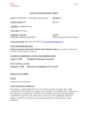
C14-2020-0071 1 ZONING CHANGE REVIEW SHEET CASE: C14-2020-0071 – 2108 Prather Lane Rezoning DISTRICT: 5 ZONING FROM: SF-3 TO: SF-5 ADDRESS: 2108 Prather Lane SITE AREA: 0.39 acres PROPERTY OWNER: Prather Development (Donald Wait) AGENT: Thrower Design, LLC (Ron Thrower) CASE MANAGER: Kate Clark (512-974-1237, kate.clark@austintexas.gov) STAFF RECOMMENDATION: Staff recommends urban family residence (SF-5) district zoning. For a summary of the basis of staff’s recommendation, see page 2. PLANNING COMMISSION ACTION / RECOMMENDATION: August 11, 2020 Scheduled for Planning Commission CITY COUNCIL ACTION: September 3, 2020 Planned to be Scheduled for City Council ORDINANCE NUMBER: ISSUES No known issues at this time. CASE MANAGER COMMENTS: This property is approximately 0.39 acres in size and is currently developed with a single residential unit. It is located at the northeast corner of Prather Lane and Keats Drive. Adjacent to the north and east are properties zoned SF-3. Across Prather Lane to the south are properties zoned GR, SF-6 and SF-3. Across Keats Drive to the west is the Ann Richards School on a property zoned SF-3. See Exhibit A: Zoning Map and Exhibit B: Aerial Map for current conditions. 1 of 9B-08 C14-2020-0071 2 BASIS OF RECOMMENDATION: 1. The proposed zoning should be consistent with the purpose statement of the district sought. Zoning changes should promote compatibility with adjacent and nearby uses. The SF-5 base zoning district is intended for moderate density single-family residential use. In appropriate locations, limited two family, duplex, townhouse, and condominium residential uses are permitted under standards which maintain single-family neighborhood characteristics. The applicant is proposing to keep the existing structure on site and add two additional single-family homes to the property. Rezoning this property to SF-5 would be consistent with the purpose statement of the district and allow for additional housing units similar in character with the existing neighborhood. EXISTING ZONING AND LAND USES: Zoning Land Uses Site North South East West SF-3 SF-3 SF-3 SF-3 Single-family residential Single-family residential GR, SF-6, SF-3 Multifamily and single-family residential Single-family residential Educational Facility (Ann Richards School) NEIGHBORHOOD PLANNING AREA: South Lamar (Suspended) TIA: deferred until site plan submittal. WATERSHED: West Bouldin Creek (urban) OVERLAYS: ADU Approximate Area Reduced Parking, Residential Design Standards. SCHOOLS: Joslin Elementary, Covington Middle and Crockett High Schools NEIGHBORHOOD ORGANIZATIONS Austin Independent School District Austin Lost and Found Pets Austin Neighborhoods Council Bike Austin Friends of Austin Neighborhoods Homeless Neighborhood Association Neighborhood Empowerment Foundation Perry Grid 614 Preservation Austin SELTexas Sierra Club, Austin Regional Group South Central Coalition TNR BCP - Travis County Natural Resources 2 of 9B-08 C14-2020-0071 3 AREA CASE HISTORIES: Number Request Commission City Council C14-2019-0114 SF-3 to SF-6 To grant staff recommended Approved SF-6 as Commission recommended (10/3/19) 2111 Prather Ln. C14-2007-0192 SF-3 to LO Habibi's Hutch Day Care 2006 Bert Ave. To grant staff recommended Approved LO-CO; CO prohibited the following uses: Communication services, Club or lodge, Convalescent services, Cultural services, Hospital services (limited) RELATED CASES: There are no related cases on this property. EXISTING STREET CHARACTERISTICS: Street ROW Pavement Classification Sidewalks Bike Route Capital Metro (within ¼ mile) Prather Lane 60’ 37’ Level 1 Keats Drive 50’ 28’ Level 1 N/A N/A Yes Yes 1 side 1 side OTHER STAFF COMMENTS: Comprehensive Planning This rezoning case is located within the boundaries of the Activity Centers for Redevelopment in Sensitive Environmental Areas Lamar & Ben White and less than 1,000 feet from the South Lamar Activity Corridor. This case is not located within the boundaries of an adopted neighborhood planning area. Surrounding land uses include single family houses and a Montessori school to the north; to the south are single family houses and a condo complex; to the west is the Ann Richards School for Young Women and an apartment complex; and to the east are single family houses, a pre-school, several small businesses and a senior activity center. The proposed use is the construction of two additional single-family houses on the lot and to retain the existing structure. From the applicant: Adding two additional single-family homes to this lot will further the City’s effort to increase density through infill development opportunities. This type of infill development is desired in 3 of 9B-08 C14-2020-0071 4 established single-family neighborhoods as it provides an opportunity to increase density in the most compatible way. More importantly, the property is located across the street from the Ann Richard’s School for Young Women Leaders which is undergoing a significant, state of the art renovation costing more than $70 million dollars in voter-approved bond money. The renovation will increase the school’s capacity to accommodate more than 1,000 students. Connectivity A Cap Metro transit stop is located within 600 linear feet from the subject property. Public sidewalks are only located on one side along Prather Lane and Keats Drive and on the opposite side of the street from the subject property. The mobility options in this area are good, while the connectivity options are excellent. Within 1,000 linear feet of this property is a public school, two private schools, a senior rec center, a daycare center, and a retail shopping center, including a food co-op and a Target store. Imagine Austin The Imagine Austin Growth Concept Map identifies this property as being within the ‘Lamar and Ben White Activity Center for Redevelopment in Sensitive Environmental Area’, which is one of five of these type of centers. The property is also approximately 1,000 feet from the South Lamar Activity Corridor. Page 106 of the Imagine Austin Comprehensive Plan states, “Five centers are located over the recharge or contributing zones of the Barton Springs Zone of the Edwards Aquifer or within water-supply watersheds. These centers are located on already developed areas and, in some instances, provide opportunities to address long-standing water quality issues and provide walkable areas in and near existing neighborhoods. State-of-the-art development practices will be required of any redevelopment to improve stormwater retention and the water quality flowing into the aquifer or other drinking water sources. These centers should also be carefully evaluated to fit within their infrastructural and environmental context. One of the Land Use and Transportation policies, LUT P21 (p. 102), clarifies the intent, “Ensure that redevelopment in the Edwards Aquifer’s recharge and contributing zones maintains the quantity and quality of recharge of the aquifer.” The following Imagine Austin policies are applicable to this case: • LUT P4. Protect neighborhood character by directing growth to areas of change that includes designated redevelopment areas, corridors and infill sites. Recognize that different neighborhoods have different characteristics and new and infill development should be sensitive to the predominant character of these communities. • HN P10. Create complete neighborhoods across Austin that have a mix of housing types and land uses, affordable housing and transportation options, and access to schools, retail, employment, community services, and parks and recreation options. Based upon this property being located near walkable neighborhood goods and services; mobility strengths; being near an Activity Corridor; and supporting the Imagine Austin policies referenced above, this project supports the Imagine Austin Comprehensive Plan. 4 of 9B-08 C14-2020-0071 5 5 of 9B-08 C14-2020-0071 6 Environmental 1. The site is not located over the Edwards Aquifer Recharge Zone. The site is located in the West Bouldin Creek Watershed of the Colorado River Basin, which is classified as an Urban Watershed by Chapter 25-8 of the City's Land Development Code. 2. Zoning district impervious cover limits apply in the Urban Watershed classification. 3. According to floodplain maps there is no floodplain within or adjacent to the project location. 4. At this time, site specific information is unavailable regarding vegetation, areas of steep slope, or other environmental features such as bluffs, springs, canyon rimrock, caves, sinkholes, and wetlands. 5. This site is required to provide on-site water quality controls (or payment in lieu of) for all development and/or redevelopment when 8,000 square feet cumulative is exceeded, and on-site control for the two-year storm. 6. At this time, no information has been provided as to whether this property has any preexisting approvals that preempt current water quality or Code requirements. 1. Any new development is subject to Subchapter F, Residential Design Standards. Additional comments will be made when the site plan is submitted. 1. A traffic impact analysis was not required for this case because the traffic generated by the proposed zoning does not exceed the threshold of 2,000 vehicle trips per day. [LDC 25-6-113] Site Plan Transportation Austin Water Utility 1. The landowner intends to serve the site with City of Austin water and wastewater utilities. The landowner, at own expense, will be responsible for providing any water and wastewater utility improvements, offsite main extensions, utility relocations and or abandonments required by the land use. The water and wastewater utility plan must be reviewed and approved by Austin Water for compliance with City criteria and suitability for operation and maintenance. Depending on the development plans submitted, water and or wastewater service extension requests may be required. All water and wastewater construction must be inspected by the City of Austin. 6 of 9B-08 C14-2020-0071 7 The landowner must pay the City inspection fee with the utility construction. The landowner must pay the tap and impact fee once the landowner makes an application for a City of Austin water and wastewater utility tap permit. INDEX OF EXHIBITS TO FOLLOW Exhibit A: Zoning Map Exhibit B: Aerial Map 7 of 9B-08 38233-A17111432171311B-268104316121265117714D92149256B-113131215102C14-2020-0071GRLO-COLO-MUSF-3NOLOSF-3GR-VLO-MUSF-4ASF-3LO-COMF-2SF-3LOLOSF-3LOMF-2SF-6BERT AVEBYRON DRMENCHACA RDVICTORY DRWORDSWORTH DRKEATS DRPRATHER LNG19±This map has been produced by the Communications Technology Management Dept. on behalf of thePlanning Development Review Dept. for the sole purpose of geographic reference. No warranty is madeby the City of Austin regarding specific accuracy or completeness.ZONING CASE#:LOCATION:SUBJECT AREA:GRID:MANAGER:C14-2020-00712108 Prather Lane.39 ACRESG19KATE CLARK1'' = 150'ZONING BOUNDARYCREEK BUFFERPENDING CASE!!!!!!SUBJECT TRACT2108 Prather Lane Rezoning8 of 9B-08 38233-A17111432171311B-268104316121265117714D92149256B-113131215102C14-2020-0071GRLO-COLO-MUSF-3NOLOSF-3GR-VLO-MUSF-4ASF-3LO-COMF-2SF-3LOLOSF-3LOMF-2SF-6BERT AVEBYRON DRMENCHACA RDVICTORY DRWORDSWORTH DRKEATS DRPRATHER LNG19Copyright nearmap 2015±This map has been produced by the Communications Technology Management Dept. on behalf of thePlanning Development Review Dept. for the sole purpose of geographic reference. No warranty is madeby the City of Austin regarding specific accuracy or completeness.ZONING CASE#:LOCATION:SUBJECT AREA:GRID:MANAGER:C14-2020-00712108 Prather Lane.39 ACRESG19KATE CLARK1'' = 150'ZONING BOUNDARYCREEK BUFFERPENDING CASE!!!!!!SUBJECT TRACT2108 Prather Lane Rezoning9 of 9B-08