B-09 (NPA-2020-0017.01 - 7113 Burnet Rd, District 7) — original pdf
Backup
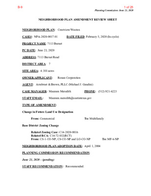
NEIGHBORHOOD PLAN AMENDMENT REVIEW SHEET Planning Commission: June 23, 2020 DATE FILED: February 5, 2020 (In-cycle) NEIGHORHOOD PLAN: Crestview/Wooten CASE#: NPA-2020-0017.01 PROJECT NAME: 7113 Burnet PC DATE: June 23, 2020 ADDRESS: 7113 Burnet Road DISTRICT AREA: 7 SITE AREA: 4.388 acres OWNER/APPLICANT: Ronan Corporation AGENT: Armbrust & Brown, PLLC (Michael J. Gaudini) CASE MANAGER: Maureen Meredith STAFF EMAIL: Maureen.meredith@austintexas.gov TYPE OF AMENDMENT: Change in Future Land Use Designation PHONE: (512) 921-6223 From: Commercial Base District Zoning Change To: Multifamily Related Zoning Case: C14-2020-0016 Related RCA: C14-72-032(RCT) From: CS-1-CO-NP, CS-CO-NP and LO-CO-NP NEIGHBORHOOD PLAN ADOPTION DATE: April 1, 2004 PLANNING COMMISSION RECOMMENDATION: June 23, 2020 – (pending) STAFF RECOMMENDATION: Recommended. To: MF-6-NP 1 of 25B-9 Planning Commission: June 23, 2020 BASIS FOR STAFF’S RECOMMENDATION: Staff supports the applicant’s request for Multifamily land use because the property is located along Burnet Road which is a commercial corridor with a mix of uses. Burnet Road is identified as an Activity Corridor in the Imagine Austin Comprehensive Plan where a mixed of commercial, office, and residential uses are appropriate. Below are sections of the Crestview/Wooten Neighborhood Plan that supports the applicant’s request. 2 LAND USE DESCRIPTIONS EXISTING LAND USE ON THE PROPERTY Commercial -Lots or parcels containing retail sales, services, hotel/motels and all recreational services that are predominantly privately owned and operated for profit (for example, theaters and bowling alleys). Included are private institutional uses (convalescent homes and rest homes in which medical or surgical services are not a main function of the institution), but not hospitals. 2 of 25B-9 Planning Commission: June 23, 2020 Purpose 1. Encourage employment centers, commercial activities, and other non‐ residential development to locate along major thoroughfares; and 2. Reserve limited areas for intense, auto‐oriented commercial uses that are generally not compatible with residential or mixed use environments. Application major highways; and 1. Focus the highest intensity commercial and industrial activities along freeways and 2. Should be used in areas with good transportation access such as frontage roads and arterial roadways, which are generally not suitable for residential development. PROPOSED LAND USE ON THE PROPERTY Multifamily Residential - Higher-density housing with 3 or more units on one lot. 1. Preserve existing multifamily and affordable housing; 2. Maintain and create affordable, safe, and well-managed rental housing; and 3. Make it possible for existing residents, both homeowners and renters, to continue to live in their neighborhoods. 4. Applied to existing or proposed mobile home parks. Purpose Application 1. Existing apartments should be designated as multifamily unless designated as mixed use; 2. Existing multifamily-zoned land should not be recommended for a less intense land use category, unless based on sound planning principles; and 3. Changing other land uses to multifamily should be encouraged on a case-by-case basis. IMAGINE AUSTIN PLANNING PRINCIPLES 1. Create complete neighborhoods across Austin that provide a mix of housing types to suit a variety of household needs and incomes, offer a variety of transportation options, and have easy access to daily needs such as schools, retail, employment, community services, and parks and other recreation options. 3 3 of 25B-9 Planning Commission: June 23, 2020 • The property is located along Burnet Road which is identified as an Activity Corridor in the Imagine Austin Comprehensive Plan. The proposed development of 360 apartment units will add to mix of housing types in Austin. Burnet Road has access to public transportation and numerous businesses. 2. Support the development of compact and connected activity centers and corridors that are well-served by public transit and designed to promote walking and bicycling as a way of reducing household expenditures for housing and transportation. • The property is located along Burnet Road which is identified as an Activity Corridor in the Imagine Austin Comprehensive Plan. The proposed development of 360 apartment units will add to mix of housing types in Austin. Burnet Road has access to public transportation and numerous businesses. 3. Protect neighborhood character by ensuring context-sensitive development and directing more intensive development to activity centers and corridors, redevelopment, and infill sites. • The property is located on an Activity Corridor as identified in the Imagine Austin Comprehensive Plan. 4. Expand the number and variety of housing choices throughout Austin to meet the financial and lifestyle needs of our diverse population. • The applicants proposed use of 360 multifamily dwelling units will expand the number of housing choices in Austin. 5. Ensure harmonious transitions between adjacent land uses and development intensities. • Multifamily land use is appropriate in this location along an Activity Corridor with a mixed of uses. 6. Protect Austin’s natural resources and environmental systems by limiting land use and transportation development over environmentally sensitive areas and preserve open space and protect the function of the resource. • The property is not located in an environmentally sensitive area of the city. 7. Integrate and expand green infrastructure—preserves and parks, community gardens, trails, stream corridors, green streets, greenways, and the trails system—into the urban environment and transportation network. 8. Protect, preserve and promote historically and culturally significant areas. • To staff’s knowledge there is no historic or cultural significance to this property • Not applicable. or buildings. 9. Encourage active and healthy lifestyles by promoting walking and biking, healthy food choices, access to affordable healthcare, and to recreational opportunities. • Not directly applicable. strong and adaptable workforce. 10. Expand the economic base, create job opportunities, and promote education to support a 4 4 of 25B-9 Planning Commission: June 23, 2020 11. Sustain and grow Austin’s live music, festivals, theater, film, digital media, and new • Not directly applicable. creative art forms. • Not applicable. 12. Provide public facilities and services that reduce greenhouse gas emissions, decrease water and energy usage, increase waste diversion, ensure the health and safety of the public, and support compact, connected, and complete communities. • Not applicable. Proximity to Imagine Austin Activity Centers and Corridors 5 5 of 25B-9 Proximity to Park Facilities Planning Commission: June 23, 2020 6 6 of 25B-9 Proximity to Public Transportation Planning Commission: June 23, 2020 IMAGINE AUSTIN GROWTH CONCEPT MAP Definitions Neighborhood Centers - The smallest and least intense of the three mixed-use centers are neighborhood centers. As with the regional and town centers, neighborhood centers are walkable, bikable, and supported by transit. The greatest density of people and activities in neighborhood centers will likely be concentrated on several blocks or around one or two intersections. However, depending on localized conditions, different neighborhood centers can be very different places. If a neighborhood center is designated on an existing commercial area, such as a shopping center or mall, it could represent redevelopment or the addition of housing. A new neighborhood center may be focused on a dense, mixed-use core surrounded by a mix of housing. In other instances, new or redevelopment may occur incrementally and concentrate people and activities along several blocks or around one or two intersections. Neighborhood centers will be more locally focused than either a regional or a town center. Businesses and services—grocery and department stores, doctors and dentists, shops, branch libraries, dry cleaners, hair salons, schools, restaurants, and other small and local businesses—will generally serve the center and surrounding neighborhoods. Town Centers - Although less intense than regional centers, town centers are also where many people will live and work. Town centers will have large and small employers, although 7 7 of 25B-9 Planning Commission: June 23, 2020 fewer than in regional centers. These employers will have regional customer and employee bases, and provide goods and services for the center as well as the surrounding areas. The buildings found in a town center will range in size from one-to three-story houses, duplexes, townhouses, and rowhouses, to low-to midrise apartments, mixed use buildings, and office buildings. These centers will also be important hubs in the transit system. Job Centers - Job centers accommodate those businesses not well-suited for residential or environmentally- sensitive areas. These centers take advantage of existing transportation infrastructure such as arterial roadways, freeways, or the Austin-Bergstrom International airport. Job centers will mostly contain office parks, manufacturing, warehouses, logistics, and other businesses with similar demands and operating characteristics. They should nevertheless become more pedestrian and bicycle friendly, in part by better accommodating services for the people who work in those centers. While many of these centers are currently best served by car, the growth Concept map offers transportation choices such as light rail and bus rapid transit to increase commuter options. Corridors - Activity corridors have a dual nature. They are the connections that link activity centers and other key destinations to one another and allow people to travel throughout the city and region by bicycle, transit, or automobile. Corridors are also characterized by a variety of activities and types of buildings located along the roadway — shopping, restaurants and cafés, parks, schools, single-family houses, apartments, public buildings, houses of worship, mixed-use buildings, and offices. Along many corridors, there will be both large and small redevelopment sites. These redevelopment opportunities may be continuous along stretches of the corridor. There may also be a series of small neighborhood centers, connected by the roadway. Other corridors may have fewer redevelopment opportunities, but already have a mixture of uses, and could provide critical transportation connections. As a corridor evolves, sites that do not redevelop may transition from one use to another, such as a service station becoming a restaurant or a large retail space being divided into several storefronts. To improve mobility along an activity corridor, new and redevelopment should reduce per capita car use and increase walking, bicycling, and transit use. Intensity of land use should correspond to the availability of quality transit, public space, and walkable destinations. Site design should use building arrangement and open space to reduce walking distance to transit and destinations, achieve safety and comfort, and draw people outdoors. BACKGROUND: The application was filed on February 3, 2020, which is in-cycle for neighborhood planning areas located on the west side of I.H.-35. The applicant proposes to change the land use on the future land use map (FLUM) from Commercial to Multifamily. The applicant has an associated zoning case where they propose to rezone the property from CS-1-CO-NP (Commercial Liquor Sales district – Conditional Overlay- Neighborhood Plan), CS-CO-NP (General Commercial Service district – Conditional Overlay – Neighborhood Plan) and LO-CO-NP (Limited Office district – Conditional Overlay – Neighborhood Plan to 8 8 of 25B-9 Planning Commission: June 23, 2020 MF-6-NP (Multifamily Highest Density district – Neighborhood Plan) to building approximately 360 apartment units. For more information on the proposed zoning, please see zoning case report C14-2020-0016. PUBLIC MEETINGS: The ordinance-required community meeting was held on March 3, 2020. Approximately 519 meeting notices were mailed to people who rent or own property within 500 feet of the subject tract, in addition to neighborhood organizations and environmental groups who requested notification for the area. Twenty-three people attended the meeting, including agents representing the applicant and one city staff member. After city staff gave a brief presentation, the applicant’s agent, Michael Gaudini, the applicant’s agent, said they had meeting with the Crestview Neighborhood Plan Contact Team and Crestview Neighborhood Association prior to this city-sponsored meeting. He said the property is where the Dallas Night Club was located, along with other small businesses. The proposed zoning is MF-6-NP to build a 360-dwelling unit multifamily development. They are asking for MF-6 because they need the site development standards. He said the proposed zoning under the new code is MU5A-Q and MU3A-Q. He said they could do the proposed development under the proposed new zoning, but they decided to move forward at this time because they were unsure of the implementation timeline of the new code. Michael also went over the hand-out he distributed to the attendees, which is provided below. After Michael Gaudini’s presentation, the following questions were asked: Q. It seems late to be bringing in people who would be directly affected. A. This has not already been decided. This is only the beginning of the City process. We reached out to the Crestview NPCT and the Crestview NA. It was my understanding they also tried to get people in the immediate vicinity, but I don’t know how they did the outreach. Q. MF-5 zoning district limits the development to 54 dwelling units per acre, the MF-6 does not. A. You are correct. Q. The owners are proposing a multifamily development, but they could sell the property? A. Yes. Q. So the proposed development is all multifamily with no commercial? A. Yes, this is correct. The property is long and not suitable for commercial uses because it’s not accessible. It’s currently 40% vacant. There’s not much frontage along Burnet Road to have commercial fronting on Burnet. Q. We have flooding in the neighborhood. Will you be hooked up to City water? A. We will meet the City’s water quality regulations required by the Code. Yes, we will be hooked up to City water. 9 9 of 25B-9 Planning Commission: June 23, 2020 Q. The current zoning of CS allows a maximum height of 60 ft. The proposed zoning of MF- 6 allows up to 90 feet. A. We don’t want the 90 feet that would be allowed under the MF-6. We maybe need 60-75 feet with five to six floors. Q. Could you go 90 feet on the entirety of the property? A. We could go 90 feet on the front part of the property along Burnet Road, but the back part could go 65 feet. Q. What about the parking? A. We will meet the parking requirements required by the Land Development Code. For the old code, there are parking minimum requirements. For the new code, there are parking maximum requirements. Q. So if you have 360 dwelling units and there are two cars per unit, which would be 720 cars. Our neighborhood already have traffic problems. A. The City looks at a transportation manual that determines how many parking spaces would be required. The average would be somewhere between 1.5 – 1.7 parking spaces per unit. There would be few parking spaces under the new code than would be required under the old code. However, the applicant is incentivized to have more parking than less parking. Parking is important for our projects to work. For the Downtown area, there are no parking requirements, but new buildings always provide parking anyway. As far as the traffic impact, the City review could require traffic mitigation to improve an intersection, for example, but the mitigation must be specific to our project. Q. If this gets approved, this would open the flood gates for more rezoning. A. There are zoning cases on every agenda. Q. I live on the street behind your development. I’m afraid of a tall building next to my home. I want a lower building near the neighborhood. A. As a concession to the neighborhood, we will step-back from the property. Q. There appears to be two lots on the property. Why not only develop the front lot? A. We will work with the neighborhood with a Restrictive Covenant to address any negative conditions with the neighborhood. Q. I think multifamily is appropriate on Burnet Road, but the big issue to the 90 feet height. It’s excessive. A. We want the MF-6 zoning for the site development standards, not for the 90 feet height. We can continue to talk with you to figure out the concession points on the height of the buildings. Q. Would you provide a two-story RC near the single family area? A. Yes, but we’d have to go to three-story. 10 10 of 25B-9 Planning Commission: June 23, 2020 Q. You will have apartments with balconies looking into the single family back yards. A. There are different ways to mitigate this by providing landscaping with tall trees and the city requires a landscape buffer. Q. What would be the maximum height of the fence? A. We would do an 8-foot fence, if the Code allows. Q. Will the units be rental or purchase? A. They will be rental units, but no short-term rentals. Q. MF-6 is mostly in the downtown area. Where are there MF-6? A. There is some MF-6 along Koenig Road. 90 feet buildings are hard to build with wood. You would need to build with steel and concrete to build 90 feet. Q. There would be an affordability requirement under the new code. A. Yes, that’s correct. We are proposing 10% affordability at 60% MFI. Q. How many properties have you developed in Austin? A. About eight. I can send you our website. Q. What would be the rental prices for the affordable units and the market-rate units? A. The affordable units would be, I think, for a family of four with a MFI of $46,000, the rents cannot exceed 30% of their income. For the market rate, there would be 324 units. The small one-bedroom to two-bedroom would be about $1,100 - $2,400 a month. Q. How will you plan the ingress/egress of the traffic? A. Austin Transportation and Austin Fire Department says where we can have curb cuts. We have two, but I don’t know if they will allow us to keep the two we have. There will be no access through the neighborhood. There is a medium on Burnet Road. We are at the mercy of the City. There will probably be a right-in/right-out with people taking a U-turn at the light. Q. Right now, it looks like there is 100% impervious cover. Where will you put the water detention pond? A. If we develop under the old code, we will meet the water quality/detention requirements. The new code is more complex. We don’t really know what it will require. Q. How will you do a possible fence with a one-car-in/one-car-out? A. There would be an open area on Burnet Road for residential access. We are interested in a gate entrance off Burnet Road with access with a key fob. Q. How can we enforce the Restrictive Covenant with a future owner? A. The RC would be private and the city would not enforce it. If the City still allows the use of Conditional Overlays, we could use this, but CO’s are not in the new code. 11 11 of 25B-9 Planning Commission: June 23, 2020 ACTION: CITY COUNCIL DATE: Not scheduled at this time 12 12 of 25B-9 Applicant Summary Letter from Application Planning Commission: June 23, 2020 13 13 of 25B-9 Planning Commission: June 23, 2020 Letter of Recommendation from the Crestview Neighborhood Plan Contact Team (NPCT) No letter was received at the time the report was submitted. 14 14 of 25B-9 Planning Commission: June 23, 2020 Site • 15 15 of 25B-9 Planning Commission: June 23, 2020 16 16 of 25B-9 Planning Commission: June 23, 2020 17 17 of 25B-9 Planning Commission: June 23, 2020 18 18 of 25B-9 Planning Commission: June 23, 2020 19 19 of 25B-9 Planning Commission: June 23, 2020 20 20 of 25B-9 Planning Commission: June 23, 2020 21 21 of 25B-9 Planning Commission: June 23, 2020 22 22 of 25B-9 Correspondence Received Planning Commission: June 23, 2020 23 23 of 25B-9 Planning Commission: June 23, 2020 24 24 of 25B-9 Planning Commission: June 23, 2020 25 25 of 25B-9