B-14 (C14-2020-0043 - 1809 W. Anderson Ln, District 7) — original pdf
Backup
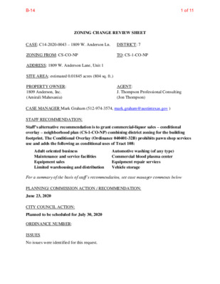
ZONING CHANGE REVIEW SHEET CASE: C14-2020-0043 – 1809 W. Anderson Ln. DISTRICT: 7 ZONING FROM: CS-CO-NP TO: CS-1-CO-NP ADDRESS: 1809 W. Anderson Lane, Unit 1 SITE AREA: estimated 0.01845 acres (804 sq. ft.) PROPERTY OWNER: 1809 Anderson, Inc. (Amirali Mahesania) AGENT: J. Thompson Professional Consulting (Jon Thompson) CASE MANAGER Mark Graham (512-974-3574, mark.graham@austintexas.gov ) STAFF RECOMMENDATION: Staff’s alternative recommendation is to grant commercial-liquor sales – conditional overlay – neighborhood plan (CS-1-CO-NP) combining district zoning for the building footprint. The Conditional Overlay (Ordinance 040401-32B) prohibits pawn shop services use and adds the following as conditional uses of Tract 108: Adult oriented business Maintenance and service facilities Equipment sales Limited warehousing and distribution Automotive washing (of any type) Commercial blood plasma center Equipment repair services Vehicle storage For a summary of the basis of staff’s recommendation, see case manager comments below PLANNING/ COMMISSION ACTION / RECOMMENDATION: June 23, 2020 CITY COUNCIL ACTION: Planned to be scheduled for July 30, 2020 ORDINANCE NUMBER: No issues were identified for this request. ISSUES 1 of 11B-14 C14-2020-0043 2 CASE MANAGER COMMENTS: The subject commercial tract is located midblock, on the south side of West Anderson Lane between Rutgers Avenue and Mullen Drive. The application lists a 4,543 square foot (0.1043 acre) lot and the trip generation worksheet lists an 800 square foot building. The survey of the building footprint calculates the rezoning area is 804 square feet. Applicant requests rezoning the building from general commercial services – conditional overlay – neighborhood plan (CS- CO-NP) to commercial-liquor sales – conditional overlay – neighborhood plan (CS-1-CO-NP). Crestview/Wooten Neighborhood Plan In April 2004, the Crestview Neighborhood Plan (Ord. # 20040401-32B) rezoned about 650.5 acres to add a neighborhood plan combining district to the base zoning and to change the base zoning districts on 43 tracts of land. The subject lot was listed as Tract 108 in the Ordinance. The base zoning remained general commercial services (CS) district and the conditional overlay and neighborhood plan (CO-NP) were added. Part 5 of the Crestview Ordinance lists Tracts 105 to 111 (including the subject tract) as tracts that may be developed as a neighborhood mixed use building special use as set forth in Sections 25-2-1502 through 1504 of the Code. Part 7.(7) of the Crestview Ordinance added the following uses as conditional uses of Tract 108: Adult oriented businesses Maintenance and service facilities Equipment sales Limited warehousing and distribution Automotive washing (of any type) Commercial blood plasma center Equipment repair services Vehicle storage Part 7.(19) of the Crestview Ordinance lists pawn shop services use as a prohibited use for the subject tract. Part 7.(25) of the Crestview Ordinance listed the maximum number of dwelling units as 27.2 units per acre. The Crestview/Wooten Combined Neighborhood Plan shows land use along West Anderson Lane as mixed use along both sides from Burnet Road to east of Wooten/Woodrow. With the limits listed above for conditional uses, prohibited uses and maximum dwelling units, the subject tract is shown on the Future Land Use Map (FLUM) as “mixed use.” The requested CS-1 zoning is allowed without amendment to the FLUM. Existing Conditions The subject 30-foot-wide tract takes access from West Anderson Lane and appears to share cross access with the strip retail building to the west. That is necessary because the east side is fenced and there is not enough lot width to accommodate parking and a two-way drive aisle. All of the tract visible from Anderson is covered with pavement or building. The lot is flat and there are four parking spaces, a sign, and a nondescript block building. A 25 foot landscaped buffer is required behind the building which is contiguous with family residence district (SF-3) zoning. 2 of 11B-14 C14-2020-0043 3 West Anderson Lane is a Level 3 (minor arterial) roadway with 4 travel lanes and a center turn lane. Anderson is a Capital Metro bus route with an eastbound stop approximately 750 feet east at Woodrow Avenue. The westbound stop is about 300 feet west at Mullen Drive. There are continuous sidewalks on both sides of the street. Bike lanes are striped on both sides of Anderson. The Austin Strategic Mobility Plan (ASMP) describes future improvements: a protected bike lane for all ages and abilities; a future raised median; access control by consolidating driveways. BASIS OF RECOMMENDATION: 1. The proposed zoning should be consistent with the purpose statement of the district sought. The proposed commercial-liquor sales zoning is consistent with the Future Land Use Map (FLUM) for the Crestview Neighborhood Plan, which shows mixed use for West Anderson Lane including the subject tract. The applicant proposes a liquor store which is first permitted in the commercial-liquor sales (CS-1) zoning district. 2. The proposed zoning should satisfy a real public need and not provide special privilege to the owner. There are no other commercial-liquor sales (CS-1) zoned properties in the segment of Anderson between Burnet Road and Research Boulevard. The Neighborhood Plan specifically listed CS-1 as one of the zones that would be consistent with the other mixed uses allowed in the area mapped for mixed uses by the Future Land Use Map along West Anderson Lane. Liquor sales adds to the variety of stores and services available on the Anderson Activity Corridor. Because the proposed rezoning is on the existing commercial corridor, it does not encroach on the residential uses. Increased variety of shopping enhances the commercial vitality of the corridor. 3. No change in conditions has occurred within the area indicating that there is a basis for changing the development restrictions for the property. Staff recommends rezoning the building footprint for commercial-liquor sales-conditional overlay-neighborhood plan (CS-1-CO-NP). The conditional overlay limits land intensive and auto-related businesses. The overlay is common to all of the other commercial properties in the Crestview Neighborhood Plan along West Anderson Lane between Burnet Road and Research Boulevard since adopted in 2004. The overlay conditions also support a walkable, bikeable commercial corridor serving the neighborhoods and community. 3 of 11B-14 C14-2020-0043 4 EXISTING ZONING AND LAND USES: Site North South East Zoning Land Uses CS-CO-NP GR-CO-NP SF-3-NP Restaurant – limited (Vacant) Retail, personal services Single family residences CS-CO-NP, GR-CO-NP Retail, across Rutgers; retail (Vacant), personal services West GR-CO-NP Personal services, business services, across Mullen: retail, restaurant NEIGHBORHOOD PLANNING AREA: Crestview/Wooten Combined (Crestview) TIA: The traffic impact determination is deferred to site plan submittal when land use and intensity is finalized. WATERSHED: Shoal Creek – Urban: Maximum 95% impervious cover in CS-1 zoning. OVERLAYS: ADU Approximate Area Reduced Parking; Residential Design Standards: LDC 25-2-Subchapter F; Selected Sign Ordinances SCHOOLS: Brentwood Elementary Lamar Middle McCallum High NEIGHBORHOOD ORGANIZATIONS Austin Independent School District Austin Lost and Found Pets Austin Neighborhoods Council Bike Austin, Crestview Neighborhood Assn. Crestview Neighborhood Plan Contact Team Friends of Austin Neighborhoods Homeless Neighborhood Association Neighborhood Empowerment Foundation North Austin Neighborhood Alliance SEL Texas Shoal Creek Conservancy Sierra Club, Austin Regional Group 4 of 11B-14 C14-2020-0043 5 AREA CASE HISTORIES: C14-2009-0065 Number Request Commission City Council To grant Apvd., 10/05/2009 Ord # 20090924-091 Crestview Vertical Mixed Use Bldg. (V) Zoning Opt-in /Opt-out process. Rezone 29.7 ac to add vertical mixed use building (V) combining district to certain tracts located in Crestview Neighborhood Planning Area. Combining District. Rezoning 626.77 acres to add NP to each base zoning district within the property and to change the base zoning districts on 61 tracts of land within the property. C14-04-0004.001 Wooten Neighborhood Plan To grant Apvd., 04/01/2004 Ord. # 040401-32A RELATED CASES: NP -04-0017 Neighborhood Plan C14-04-0004.002 Crestview NPCD Legal Description: a portion of Lot 9A, Resubdivision of Lot 9, Block 7 Crestview Addition Sec. 12 an addition in Travis County, Texas, according to the map or plat thereof, recorded in Volume 29, Page 8, Plat Records, Travis County, Texas. OTHER STAFF COMMENTS: Comprehensive Planning This rezoning case is located on the south side of West Anderson Lane and west of Rutgers Avenue, on a 0.104 acre lot. The subject property is located along the West Anderson Activity Corridor, three-quarters of a mile from the Crestview Station Town Center and within the boundaries of the Crestview/Wooten Combined Neighborhood Planning Area, in the Crestview NP. Surrounding land uses includes a café, art school, tattoo parlor, auto repair shop and detached family residential area to the north; to the south is a detached family residential subdivision; to the west are retail uses and a medical clinic; and to the east are retail uses. 5 of 11B-14 C14-2020-0043 6 Connectivity Public sidewalks and bike lanes are located on both sides of Anderson Lane, although there are numerous wide driveways and curb cut intrusions along this street. The eastbound Capitol Metro transit stop is located within 750 feet of this property. The mobility and connectivity options in the area are average. Crestview/Wooten Combined Neighborhood Planning Area (CWCNP) The CWCNP Future Land Use Plan identifies this portion of the planning area as Mixed Use, which allows zone CS-1 in this Future Land Use Category. Mixed Use is defined as an area that is intended for a mix of residential and non-residential uses, including office, retail and commercial services. The CWCNP policies and text below are applicable to this case. Goal 5: Promote enhancement of major corridors by encouraging better quality and a mix of neighborhood serving development and redevelopment and discouraging strip development. (p. 24) Land Use Objective 2: Encourage the development of neighborhood-serving commercial and mixed use on Anderson Lane and Burnet Road. (p. 26) Text: Both Anderson Lane and Burnet Road are nearly fully developed as commercial corridors. The types of commercial uses vary widely, including numerous auto sale and service establishments and multi-tenant shopping centers. Care should be taken to ensure that redevelopment serves to strengthen these two retail corridors and maintain their utility as shopping districts. The neighborhood generally agrees that mixed-use development is acceptable on Anderson and Burnet. Excerpt: The existing zoning on the corridors is generally appropriate, but land area intensive. Auto-related uses should be limited to help maintain the retail viability of both corridors. Recommendations: (p. 27) 4. Discourage additional commercial uses from “creeping” away from the commercial corridors onto residential streets. 6 of 11B-14 C14-2020-0043 7 5. Add a conditional overlay to properties on Anderson Lane and Burnet Road south of Anderson limiting automotive & equipment related uses and uses (such as pawn shops) that may make the commercial areas appear blighted. The proposed neighborhood serving commercial use appears to support the policies and text the CWCNP. Imagine Austin The property is located along an ‘Activity Corridor’ (Anderson Lane) which is characterized by a variety of activities and types of buildings located along the roadway, and are intended to allow people to reside, work, shop, access services, people watch, recreate, and hang out without traveling far distances. The following IACP policies are also relevant to this case: • LUT P1. Align land use and transportation planning and decision-making to achieve a compact and connected city in line with the growth concept map. • LUT P3. Promote development in compact centers, communities, or along corridors that are connected by roads and transit that are designed to encourage walking and bicycling, and reduce health care, housing and transportation costs. • LUT P4. Protect neighborhood character by directing growth to areas of change that includes designated redevelopment areas, corridors and infill sites. Recognize that different neighborhoods have different characteristics and new and infill development should be sensitive to the predominant character of these communities. Based on the comparable scale of this site relative to other neighborhood serving retail and commercial uses along Anderson Lane; the subject property being located along an Imagine Austin Corridor; and the policies above, this project supports the Imagine Austin Comprehensive Plan. Environmental 1. The site is not located over the Edwards Aquifer Recharge Zone. The site is located in the Shoal Creek Watershed of the Colorado River Basin, which is classified as an Urban Watershed by Chapter 25-8 of the City's Land Development Code. It is in the Desired Development Zone. 2. Zoning district impervious cover limits apply in the Urban Watershed classification. 3. According to floodplain maps there is no floodplain within or adjacent to the project location. 4. Standard landscaping and tree protection will be required in accordance with LDC 25-2 and 25-8 for all development and/or redevelopment. 7 of 11B-14 C14-2020-0043 8 5. This site is required to provide on-site water quality controls (or payment in lieu of) for all development and/or redevelopment when 8,000 s.f. cumulative is exceeded, and on site control for the two-year storm. Site Plan SP1. SP2. Site plans will be required for any new development other than single-family or duplex residential. Any development which occurs in an SF-6 or less restrictive zoning district which is located 540-feet or less from property in an SF-5 or more restrictive zoning district will be subject to compatibility development regulations. SP3. The site is subject to compatibility standards. Along the south property lines, the following standards apply: • No structure may be built within 25 feet of the property line. • No structure in excess of two stories or 30 feet in height may be constructed within 50 feet of the property line. • No structure in excess of three stories or 40 feet in height may be constructed within 100 feet of the property line. • No parking or driveways are allowed within 25 feet of the property line. • A landscape area at least 25 feet wide is required along the property line. In addition, a fence, berm, or dense vegetation must be provided to screen adjoining properties from views of parking, mechanical equipment, storage, and refuse collection. SP4. Any new development is subject to Subchapter E. Design Standards and Mixed Use. Additional comments will be made when the site plan is submitted. SP5. Development regulations for CS-1 is the following • Maximum Height: 60 Ft. • Maximum Building Coverage: 95% • Maximum Impervious Cover: 95% • Maximum FAR: 2:1 Transportation The Austin Strategic Mobility Plan (ASMP) adopted 04/11/2019, calls for 94 feet of right-of- way for W. Anderson Lane. It is recommended that 47 feet of right-of-way from the existing centerline should be dedicated for W. Anderson Lane at the time of subdivision or site plan. Existing right-of-way is sufficient for Rutgers Avenue. A traffic impact analysis determination should be deferred to the time of site plan, when land use and intensity is finalized. 8 of 11B-14 C14-2020-0043 9 Name Pavement ASMP Sidewalks Existing ROW ASMP Required ROW Classification Bicycle Route Capital Metro (within ¼ mile) W. Anderson Lane ~84’ 94’ 58’ Yes Yes Yes Rutgers Ave. ~62’ Existing 38’ No No No 3 1 Austin Water Utility AW1. The landowner intends to serve the site with City of Austin water and wastewater utilities. The landowner, at own expense, will be responsible for providing any water and wastewater utility improvements, offsite main extensions, utility relocations and or abandonments required by the land use. The water and wastewater utility plan must be reviewed and approved by Austin Water for compliance with City criteria and suitability for operation and maintenance. Depending on the development plans submitted, water and or wastewater service extension requests may be required. All water and wastewater construction must be inspected by the City of Austin. The landowner must pay the City inspection fee with the utility construction. The landowner must pay the tap and impact fee once the landowner makes an application for a City of Austin water and wastewater utility tap permit. INDEX OF EXHIBITS TO FOLLOW Exhibit A: Zoning Map Exhibit B: Aerial Map 9 of 11B-14 83-021 S R E N A E L C W A N 80-38 D E R S O N LN GR-MU-CO-NP TAIL E R E R A C Y A D MF-3-NP ( ( SF-3-NP ( ( ( ( ( SF-3-NP ( ( ( ( ( E R TAIL R Y D D R A H ( ( SF-3-NP ( ( ( ( ( ( ( ( ( ( ( SF-3-NP ( 71-194 ( SF-3-NP ( ( ( ( ( ( ( ( ( ( ( ( SF-3-NP ( DISCOUNT STORE GR-CO-NP ( ( ( S. T P A GR-MU-CO-NP R E N T AL SUPPLY REST. GR-CO-NP 72-88 SE R 68-83 V. STA. P O M PT O ( ( ( N D R ( ( ( ( ( ( ( APA RT M E NTS ( ( ( ( ( SF-3-NP ( ( ( B ELF O R D D R ( ( SF-3-NP W O O GR-MU-CO-NP APA RT M E NTS TE N PA R K D R GR-MU-CO-NP OFC\CNTR ( ( ( ( ( ( ( ( ( APA RT M E NTS ( ( GR-CO-NP ( ! ! CS-CO-NP ! GR-CO-NP SP93-0188C APA RT M E NTS OFC\CNTR SRVC\STATION E V S A R E G T U R C O ( ( ( ( ( ( ( ( ( ( R N D E L L U M ( ( ( SF-3-NP ( ( ( ( ( BA R B A R ( ( ( S H O P N V\ST PIN O R E G\C NTR SP85-041 GR-CO-NP ( ( ( ( SF-3-NP ( D U K E A V E ( ( ( ( ( ( ( ( E V A W O R D O O W SF-3-NP ( ( ( SF-3-NP ( ( ( ( SF-3-NP A ST ( ( ( ( ( ( ( ( ( ( SF-3-NP ( ( ( ( ( ( ( ( SF-3-NP ( ZONING ( ( ( B A R B A R ( ( A ST ( ( ( ( ( ( ( Exhibit A ZONING CASE#: C14-2020-0043 ( ( ( ( ( SUBJECT TRACT ! ! ! ! ! ! PENDING CASE ZONING BOUNDARY This product is for informational purposes and may not have been prepared for or be suitable for legal, engineering, or surveying purposes. It does not represent an on-the-ground survey and represents only the approximate relative location of property boundaries. 1 " = 200 ' This product has been produced by CTM for the sole purpose of geographic reference. No warranty is made by the City of Austin regarding specific accuracy or completeness. Created: 6/9/2020 ( ( ( ± 10 of 11B-14 GR-CO-NP R N D E L L U M SF-3-NP GR-CO-NP GR-CO-NP W A N D E R S O N LN C14-2020-0043 K29 CS-CO-NP SF-3-NP E V S A R E G T U R GR-CO-NP SF-3-NP Copyright nearmap 2015 ± 1'' = 50' 1809 W. ANDERSON LANE Exhibit B SUBJECT TRACT ZONING BOUNDARY ! ! ! ! ! ! PENDING CASE CREEK BUFFER ZONING CASE#: LOCATION: SUBJECT AREA: GRID: MANAGER: C14-2020-0043 1809 W. ANDERSON LANE 0.1043 ACRES K29 MARK GRAHAM This map has been produced by the Communications Technology Management Dept. on behalf of the Planning Development Review Dept. for the sole purpose of geographic reference. No warranty is made by the City of Austin regarding specific accuracy or completeness. 11 of 11B-14