B-28 (SP-2019-0253C - Springdale Farms; District 3) — original pdf
Backup
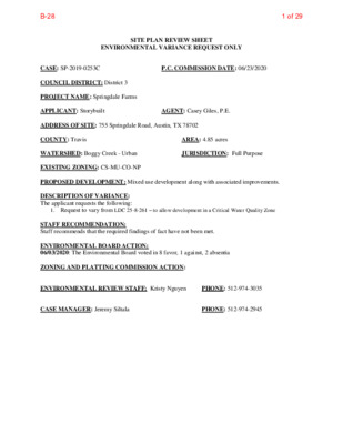
SITE PLAN REVIEW SHEET ENVIRONMENTAL VARIANCE REQUEST ONLY P.C. COMMISSION DATE: 06/23/2020 CASE: SP-2019-0253C COUNCIL DISTRICT: District 3 PROJECT NAME: Springdale Farms APPLICANT: Storybuilt ADDRESS OF SITE: 755 Springdale Road, Austin, TX 78702 COUNTY: Travis WATERSHED: Boggy Creek - Urban EXISTING ZONING: CS-MU-CO-NP PROPOSED DEVELOPMENT: Mixed use development along with associated improvements. DESCRIPTION OF VARIANCE: The applicant requests the following: AGENT: Casey Giles, P.E. JURISDICTION: Full Purpose AREA: 4.85 acres 1. Request to vary from LDC 25-8-261 – to allow development in a Critical Water Quality Zone STAFF RECOMMENDATION: Staff recommends that the required findings of fact have not been met. ENVIRONMENTAL BOARD ACTION: 06/03/2020: The Environmental Board voted in 8 favor, 1 against, 2 absentia ZONING AND PLATTING COMMISSION ACTION: ENVIRONMENTAL REVIEW STAFF: Kristy Nguyen CASE MANAGER: Jeremy Siltala PHONE: 512-974-3035 PHONE: 512-974-2945 1 of 29B-28 ENVIRONMENTAL COMMISSION MOTION 20200603-006a Date: June 3, 2020 Subject: Springdale Farms, SP-2019-0253C Motion by: Kevin Ramberg Seconded by: Mary Ann Neely RATIONALE: WHEREAS, the Environmental Commission recognizes the applicant is requesting a variance from LDC 25- 8-261 to allow development in a critical water quality zone. WHEREAS, the Environmental Commission recognizes that staff does not recommend this variance, having determined that the findings of fact have not been met. THEREFORE, the Environmental Commission recommends denial of the requested variance from LDC 25- 8-261 to allow development in a critical water quality zone. VOTE 8-1 For: Smith, Neely, Coyne, Maceo, Ramberg, Guerrero, Gordon, and Bedford Against: Thompson Abstain: None Recuse: None Absent: Creel, Nill Approved By: Linda Guerrero, Environmental Commission Chair 1 2 of 29B-28 Staff Findings of Fact Variance to LDC 25-8-261 3 of 29B-28 Development Services Department Staff Recommendations Concerning Required Findings Project Name: Ordinance Standard: Watershed Protection Ordinance Variance Request: Springdale Farms SP-2019-0253C LDC 25-8-261 – to allow development in a Critical Water Quality Zone Include an explanation with each applicable finding of fact. A. Land Use Commission variance determinations from Chapter 25-8-41 of the City Code: 1. The requirement will deprive the applicant of a privilege available to owners of similarly situated property with approximately contemporaneous development subject to similar code requirements. No Approximately 3.2 acres of the 4.85 acre property are uplands and can be developed without the need for a variance from the Land Development Code. The Land Development Code does not provide an allowance for non-complying development within the CWQZ to maximize the amount of development that can occur on the property. 2. The variance: a) Is not necessitated by the scale, layout, construction method, or other design decision made by the applicant, unless the design decision provides greater overall environmental protection than is achievable without the variance; No Due to the scale of the project to maximize development, the applicant has made a design choice to make use of the CWQZ to address Austin Fire’s code requirement for the hammerheads, which are not allowed by the Land Development Code. Moreover, to increase building square footage, there will be building overhangs over the CWQZ, creating rain shadow effect that would deprive the CWQZ of necessary rainfall and sunlight. The scale and design decisions do not provide greater overall environmental protection. See Exhibit 1 – Overall Proposed Site Plan. b) Is the minimum deviation from the code requirement necessary to allow a reasonable use of the property; 4 of 29B-28 No c) No No No In addition to the building overhangs within the CWQZ, the hammerheads encroach on both sides of the CWQZ. Development is prohibited within the CWQZ except as provided in LDC 25-8-261 which doesn’t include the stated development, thus requiring the need for a variance from the Land Development Code. Does not create a significant probability of harmful environmental consequences. The building overhangs and hammerheads within the CWQZ would deprive the CWQZ of rainfall and sunlight penetration that are necessary for riparian health, and adding impervious cover and development to the CWQZ where there wouldn’t be otherwise. Furthermore, there would be removal of native vegetation and topsoil. 3. Development with the variance will result in water quality that is at least equal to the water quality achievable without the variance. No There would be impervious cover and development within the CWQZ where there wouldn’t be otherwise. The impervious cover from the building overhangs would not be draining to the water quality pond. B. The Land Use Commission may grant a variance from a requirement of Section 25-8-422 (Water Supply Suburban Water Quality Transition Zone), Section 25-8-452 (Water Supply Rural Water Quality Transition Zone), Section 25-8-482 (Barton Springs Zone Water Quality Transition Zone), Section 25-8-368 (Restrictions on Development Impacting Lake Austin, Lady Bird Lake, and Lake Walter E. Long), or Article 7, Division 1 ( Critical Water Quality Zone Restrictions ), after determining that:: 1. The criteria for granting a variance in Subsection (A) are met; Due to the design choice and scale of the project to maximize development, the CWQZ is utilized for development that is not allowed by the Land Development Code. The site contains uplands that are developable without the need for a variance from the Land Use Commission. 2. The requirement for which a variance is requested prevents a reasonable, economic use of the entire property; The uplands area has access on both sides of the CWQZ, thus providing the maximum allowance for development of a parcel of land with a CWQZ to occur without the need to vary from the Land Development Code and would not prevent a reasonable, economic use of the entire property. 3. The variance is the minimum deviation from the code requirement necessary to allow a reasonable, economic use of the entire property. No 3.2 acres of the 4.85 acre property are uplands and can be developed without the need for a variance from the Land Development 5 of 29B-28 Code. The Land Development Code does not provide an allowance for non-complying development within the CWQZ to increase the amount of development that can occur on the property. Staff Determination: Staff determines that the findings of fact have not been met. Environmental Reviewer (DSD) Environmental Review Manager (DSD) _____________________________ _____________________________ Date ________________ Date ________________ Environmental Officer (WPD) _____________________________ Chris Herrington, P.E. Date ________________ 5/05/2020 4/21/20 Mike McDougal4/21/20206 of 29B-28 Exhibit 1: Springdale Farms SP-2019-0253C – Overall Site Plan 7 of 29B-28 Applicant Form Variance to LDC 25-8-261 8 of 29B-28 February 15, 2020 City of Austin Real Estate 505 Barton Springs Rd Austin, TX 78704 Dear Sir or Madam- Re: Administrative Waiver Request, LDC 25-8-261, SP-2019-0253C Pursuant to Land Development Code, LDC 25-8-261, we respectfully request an administrative waiver to be allowed to use pervious pavers inside the CWQZ for fire department access, as well as cantilever over a portion of the CWQZ by about 4’. The proposed site is located at 755 Springdale Road. The site totals 4.85 acres located within the City’s Full Purpose Jurisdiction and Desired Development Zone, and located within an urban watershed, East Boggy Creek. The site is subject to Compatibility setbacks/restrictions along the entire north and south property lines. The property is to be developed with a mix of commercial space, a restaurant, and residential units. A tributary to Boggy Creek flows through the middle of the site separating it into an east and west half. The site is currently in review, SP-2019-0253C, with the City of Austin for a permit. The west half of the site is designed with a 1-story underground parking garage and the east half will have a 2-story underground parking garage. The highest elevation on site is 457, and the lowest is 446. The existing site currently has a restaurant, single-family home, and an extensive urban farm with sheds, coups, and equipment. The site is approximately 11% impervious but close to 80% disturbed area. The only connection between the two sides is an existing vehicular bridge that spans the creek. No CEFs were identified in the creek, and the drainage basin is approximately 70 acres resulting in a CWQZ setback, which is much larger than 50’ because of the flat nature of the property. A majority of the site is currently used as an active farm. This site appears large but there are several factors limiting the constructible space. 1/3 of the site is consumed by the CWQZ. The creek on site requires floodplain delineation, which extends well beyond the 50-ft offset for most creeks. Another 0.76ac is encumbered by Compatibility Setbacks on the entire north and south property line. Additionally, another 0.37ac of a grove of heritage trees (calculated only to half critical root zone), and that doesn’t include two other heritage trees outside of the grove, leaving a much smaller than normal portion of the lot to develop, and in a very inefficient shape. Even with this variance we will still only be able to develop to approximately half of our entitled impervious cover and less than 1/3 of our entitled FAR, which is certainly not inappropriate scale. We feel that this is a minor variance that allows the utmost and best design/use for the site, which is already very limited by a large bisecting CWQZ, a grove of heritage trees, various other heritage trees, PSW REAL ESTATE 900 S. 1ST STREET , Suite 110 AUSTIN, TX 78704 9 of 29B-28 and compatibility setbacks. Other properties don’t have these constraints, and this variance allows development that is still reduced to below 50% of entitlements by these factors. Furthermore, the area of CWQZ that will be encroached is currently developed and in use. The area under the proposed overhang is currently farmland, and will remain so regardless of the outcome of the variance. The areas proposed for pervious fire turn arounds are currently being used for a home/yard, and also for material and equipment storage. These areas will be used for farmland if the cannot be used for the turnaround. As per the reasons above, we request for a variance to differ from LDC 25-8-261. Please feel free to contact me with any questions. Sincerely, Casey Giles, P.E. Director of Engineering Casey.Giles@Storybuilt.com 512-294-3609 10 of 29B-28 April 28, 2020 ENVIRONMENTAL COMMISSION VARIANCE APPLICATION FORM PROJECT DESCRIPTION Applicant Contact Information Variance Case Information Name of Applicant Street Address City State ZIP Code Work Phone E-Mail Address Case Name Case Number Address or Location Environmental Reviewer Name Environmental Resource Management Reviewer Name Applicable Ordinance Watershed Name Watershed Classification Casey Giles 900 S 1st Street Austin, TX 78704 5122943609 Casey.giles@Storybuilt.com Springdale SP-2019-0253C 755 Springdale Rd, 78702 Kristy Nguyen LDC 25-8-261 E Boggy Creek ☐Urban ☐Water Supply Rural ☐ Suburban ☐Water Supply Suburban ☐ Barton Springs Zone City of Austin | Environmental Commission Variance Application Guide 1 11 of 29B-28 April 28, 2020 Edwards Aquifer Recharge Zone ☐ Barton Springs Segment ☐ Northern Edwards Segment ☐ Not in Edwards Aquifer Zones Edwards Aquifer Contributing Zone Distance to Nearest Classified Waterway Water and Waste Water service to be provided by ☐ Yes ☐ No Adjacent COA/AWU Request The variance request is as follows (Cite code references): We request a variance to LDC 25-8-261 to allow a portion of a fire lane and building overhang to be constructed in/above a critical water quality zone. Impervious cover square footage: acreage: percentage: Provide general description of the property (slope range, elevation range, summary of vegetation / trees, summary of the geology, CWQZ, WQTZ, CEFs, floodplain, heritage trees, any other notable or outstanding characteristics of the property) Existing 23,900 sf .55 ac 11 Proposed 105,600 sf 2.42 ac 50 The site totals 4.85 acres located within the City’s Full Purpose Jurisdiction and Desired Development Zone. The property is located within an urban watershed, East Boggy Creek. The site is subject to Compatibility setbacks/restrictions along the entire north and south property lines. The highest elevation on site is 457, and the lowest is 446. The existing site currently has a restaurant, single-family home, and an extensive urban farm with sheds, coups, and equipment. The site is approximately 11% impervious, and is divided in two parts by a tributary to Boggy Creek that flows diagonally from the south property line to the north property line. The only connection between the two sides is an existing vehicular bridge that spans the creek. No CEFs were identified in the creek, and the drainage basin is approximately 70 acres resulting in a CWQZ setback, which is much larger than 50’ because of the flat nature of the property. A majority of the site is used as an active farm. There are 12 large heritage trees on site. City of Austin | Environmental Commission Variance Application Guide 2 12 of 29B-28 April 28, 2020 Project: Ordinance: A. 1. Clearly indicate in what way the proposed project does not comply with current Code (include maps and exhibits) The end of the proposed fire lanes require a hammer head turn around, and this turn around is proposed in the CWQZ. It will be at grade, and composed of pervious grass-crete and fully revegetated. Also, the 2nd story of the building overhangs the CWQZ by approximately 4.5’ in a few isolated areas. See attached exhibits. FINDINGS OF FACT As required in LDC Section 25-8-41, in order to grant a variance the Land Use Commission must make the following findings of fact: Include an explanation with each applicable finding of fact. Land Use Commission variance determinations from Chapter 25-8-41 of the City Code: The requirement will deprive the applicant of a privilege available to owners of similarly situated property with approximately contemporaneous development subject to similar code requirements. Yes. The property is encumbered by the expanded CWQZ, a huge grove of heritage trees, and compatibility setbacks. In addition, the property is unique in that is spans the entire block from Springdale to Mansell, but is bordered on 2 sides by residential and bisected by a dry creek bed. The CWQZ is greatly expanded by undersized culverts downstream of the property and an incredibly flat channel slope of this man-made channel. Most (if any) properties in this area do not have the artificially expanded CWQZ nor do they have a trees of this size and number, and certainly not both. 2. The variance: a) Is not necessitated by the scale, layout, construction method, or other design decision made by the applicant, unless the design decision provides greater overall environmental protection than is achievable without the variance; Yes, 1/3 of the site is consumed by the CWQZ, another 0.76ac by Compatibility Setback, and another 0.37ac of a grove of heritage trees (only to half critical City of Austin | Environmental Commission Variance Application Guide 3 13 of 29B-28 April 28, 2020 3. 1. 2. root zone), and that doesn’t include two other heritage trees outside of the grove, leaving a much smaller than normal portion of the lot to develop, and in a very inefficient shape. Even with this variance we will still only be able to develop to approximately half of our entitled impervious cover and less than 1/3 of our entitled FAR, which is certainly not inappropriate scale. Is the minimum deviation from the code requirement necessary to allow a reasonable use of the property; Yes. Dozens of layouts, analysis, and iterations have been done. Does not create a significant probability of harmful environmental consequences. No, as mentioned above, the encroached area is limited, and currently being used for a home, a farm storage area, and a farmed area. Development with the variance will result in water quality that is at least equal to the water quality achievable without the variance. Yes. Runoff from all developed areas is captured. The fire lane will be pervious and fully revegetated, and the area under the small overhang is proposed to be used as urban farming whether there is any overhang or not, so it will be healthy, stable, and irrigated regardless. b) c) B. Additional Land Use Commission variance determinations for a requirement of Section 25-8-422 (Water Quality Transition Zone), Section 25-8-452 (Water Quality Transition Zone), Article 7, Division 1 (Critical Water Quality Zone Restrictions), or Section 25-8-652 (Development Impacting Lake Austin, Lady Bird Lake, and Lake Walter E. Long): The criteria for granting a variance in Subsection (A) are met; Yes. This is a minor variance that allows the utmost and best design/use for the site, which is already very limited by a large bisecting CWQZ, a grove of heritage trees, various other heritage trees, and compatibility setbacks. Other properties don’t have these constraints, and this variance allows development that is still reduced to below 50% of entitlements by these factors. Furthermore, the area of CWQZ that will be encroached is currently developed and in use. The requirement for which a variance is requested prevents a reasonable, economic use of the entire property; Yes, as mentioned above, we will still only be developing to about half of entitled impervious cover and less than 1/3 of the entitled FAR. City of Austin | Environmental Commission Variance Application Guide 4 14 of 29B-28 April 28, 2020 3. The variance is the minimum deviation from the code requirement necessary to allow a reasonable, economic use of the entire property. Yes, the encroachments are minimal impact, one of which is only a small overhang, the other of which will still be pervious and revegetated. **Variance approval requires all above affirmative findings. City of Austin | Environmental Commission Variance Application Guide 5 15 of 29B-28 April 28, 2020 A Exhibits for Commission Variance o Aerial photos of the site o Site photos o Aerial photos of the vicinity o Context Map—A map illustrating the subject property in relation to developments in the vicinity to include nearby major streets and waterways o Topographic Map - A topographic map is recommended if a significant grade change on the subject site exists or if there is a significant difference in grade in relation to adjacent properties. o For cut/fill variances, a plan sheet showing areas and depth of cut/fill with topographic elevations. o Site plan showing existing conditions if development exists currently on the property o Proposed Site Plan- full size electronic or at least legible 11x17 showing proposed development, include tree survey if required as part of site or subdivision plan o Environmental Map – A map that shows pertinent features including Floodplain, CWQZ, WQTZ, CEFs, Setbacks, Recharge Zone, etc. o An Environmental Resource Inventory pursuant to ECM 1.3.0 (if required by 25-8-121) o Applicant’s variance request letter City of Austin | Environmental Commission Variance Application Guide 6 16 of 29B-28 Applicant Exhibits 17 of 29B-28 Springdale Farms 06/03/2020 Environmental Variance Request 9/6/2019 18 of 29B-28 Site Location • • • • • Area: 4.85 acres Zoning: CS-MU-CO-NP Along Imagine Austin Corridor 2 Blocks from Transit priority (in both directions) Activity Corridor 19 of 29B-28 Neighborhood Outreach • Held community meetings to: • Understand from our future neighbors what the Farm has meant to the community • Get a sense of what future uses could be beneficial to • Introduce StoryBuilt and discuss overall design the community strategy the site) • Preservation (trees, existing features important to • Sustainability • Green infrastructure • Neighborhood fabric • Mixed Use (residential for sale and commercial) 20 of 29B-28 Community Feedback and Project Goals Feedback from community meetings: • Keep some level of farming and farm-stand operational • Mixed use (residential and commercial) • Open space • Independent grocery • Coffee shop/cafe • Welcoming environment • Pedestrian oriented • Sub-grade parking and limited Impervious cover • Affordable housing component – based on % of total Units built 21 of 29B-28 Site Plan Site Plan: • 87 For sale Units • • • • • • +/- 65,000 sf of commercial Open Space: 2.25 ac (includes 25k sf of Urban Farm 50% Imp cover (95% Allowed) FAR: 0.7:1 (2:1 Allowed) Tree Preservation Collaboration of StoryBuilt and the NPCT to accomplish the goals: • • • • Mixed Use Farming Sub-grade parking Pedestrian Oriented 22 of 29B-28 Proposed Encroachments Encroachment: • Approximately 3500 SF of “Grass- Crete” permeable paving system within Floodplain/CWQZ with only 1200 sf being within the initial 50- ft offset to serve as Fire access • Approximately 800 SF of building overhang into proposed urban farm area (max overhang: <5’) Fire Lane Fire Lane 50-ft CWQZ offset 23 of 29B-28 Site Overview and Hardship • • • • Total Area = 211,000 sf Buildable area = 108,000 or 50% of total area due to preserving 10 Heritage Trees, floodplain, CWQZ and compatibility setbacks CWQZ created due to basin being approximately 2 acres over 64 ac minimum even though channel is manmade Less than ½ % slope to Boggy Creek drastically increases floodplain and CWQZ 24 of 29B-28 Existing Conditions and Encroachments 25 of 29B-28 Existing Conditions and Encroachments Existing Greenhouse and Material storage Existing Farming Existing Home 26 of 29B-28 CWQZ Assessment Report Conclusions: • CWQZ and floodplain within the site are in Poor to Fair Condition • • The entirety of the CWQZ within the site has been historically disturbed Proposed Grassed pavers, Urban Farming and improving the drainage channel basin and upslopes per Environmental recommendations will improve overall Zones Floodplain CWQZ 27 of 29B-28 Summary of Proposed Encroachments Encroachment and Result: 1. Permeable grass pavers: Encroachment into CWQZ but outside 50-ft of channel Centerline. Replaces existing Greenhouse and material storage/equipment parking. If Not Granted: Loss of 4 Units 2. 3. Commercial Building Overhang of Urban Farm: Negligible impact to site, rain and sunlight non-factor as all season equinoxes provide ample sunlight and irrigation available. If Not Granted: Loss of 3,500sf of leasable space Permeable grass pavers: Encroachment into CWQZ with portion within 50-ft of channel Centerline. Replaces existing impervious cover/home. If Not Granted: Loss of 3 Units Fire Lane 1 2 3 Fire Lane 50-ft CWQZ offset 28 of 29B-28 Grass Crete Windsor Apartments, South Lamar 29 of 29B-28