B-03 (NPA-2020-0015.01 - MLK & 183 Residential; District 1) — original pdf
Backup
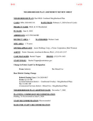
NEIGHBORHOOD PLAN AMENDMENT REVIEW SHEET DATE FILED: February 5, 2020 (Out-of-Cycle) NEIGHORHOOD PLAN: East MLK Combined Neighborhood Plan CASE#: NPA-2020-0015.01 PROJECT NAME: MLK & 183 Residential PC DATE: June 9, 2020 ADDRESS/ES: 6121 FM 969 RD DISTRICT AREA: 1 WATERSHED: Walnut Creek SITE AREA: 1.78 acres OWNER/APPLICANT: Asero Holdings Corp., a Texas Corporation, Dale Wimmer AGENT: Ferris Clements; Armbrust & Brown, PLLC, (512) 435-2337 CASE MANAGER: Rachel Tepper STAFF EMAIL: Rachel.Tepper@austintexas.gov Change in Future Land Use Designation PHONE: (512) 974-1485 From: Industry Base District Zoning Change To: Mixed Use Related Zoning Case: C14-2020-0017 From: LI-CO-NP (Limited Industrial district— Conditional Overlay—Neighborhood Plan) To: CS-MU-NP (Commercial Services district—Mixed Use—Neighborhood Plan) NEIGHBORHOOD PLAN ADOPTION DATE: November 7, 2002 PLANNING COMMISSION RECOMMENDATION: Pending. To be reviewed on June 9, 2020. STAFF RECOMMENDATION: Recommended BASIS FOR STAFF’S RECOMMENDATION: 1 of 23B-03 The Long-Range Planning staff met on Wednesday, March 11, 2020 to discuss this case and the community meeting which was held on March 5, 2020. Following discussion, staff recommended the FLUM change from Industry land use to Mixed Use because the proposed change will provide the opportunity for additional housing and density along East MLK/FM 969 which is an Imagine Austin Activity corridor. The FLUM change is in alignment with the East MLK Plan, “…the vacant and underused land on FM 969 is best suited for community-serving commercial uses, but some residential uses can be added through mixed use development.” (p.73) The 1.78-acre site is entirely surrounded by the Mixed Use land use designation. LAND USE DESCRIPTIONS EXISTING LAND USE ON THE PROPERTY Industry - Areas reserved for manufacturing and related uses that provide employment but are generally not compatible with other areas with lower intensity use. Industry includes general warehousing, manufacturing, research and development, and storage of hazardous materials. Purpose 1. To confine potentially hazardous or nuisance‐creating activities to defined districts; 2. To preserve areas within the city to increase employment opportunities and increased tax base; 3. To protect the City’s strategic advantage as a high tech job center; and 4. To promote manufacturing and distribution activities in areas with access to major transportation systems. Application 1. Make non‐industrial properties in areas with a dominant industrial character compatible with the prevailing land use scheme; 2. Where needed, require a buffer area for industrial property that abuts residentially used land; 3. Industry should be applied to areas that are not appropriate for residential or mixed use development, such as land within the Airport Overlay; 4. In general, mixed use and permanent residential activities are not appropriate in industrial areas. An exception may be the edge of an industrial area along the interface with an area in which residential activities are appropriate. Such exceptions should be considered case by case, with careful attention to both land use compatibility and design; 2 2 of 23B-03 5. Industry should not be either adjacent to or across the road from single family residential or schools; 6. Use roadways and/or commercial or office uses as a buffer between residential and industry; and 7. Smaller scale “local manufacturing” districts may be appropriate in some locations to preserve employment opportunities and cottage industries of local artisans. In these areas, hazardous industrial uses (i.e. basic industry, recycling centers, and scrap yards) should be prohibited. PROPOSED LAND USE ON THE PROPERTY Mixed Use: An area that is appropriate for a mix of residential and non-residential uses. Purpose 1. Encourage more retail and commercial services within walking distance of residents; 2. Allow live‐work/flex space on existing commercially zoned land in the neighborhood; 3. Allow a mixture of complementary land use types, which may include housing, retail, offices, commercial services, and civic uses (with the exception of government offices) to encourage linking of trips; 4. Create viable development opportunities for underused center city sites; 5. Encourage the transition from non‐residential to residential uses; 6. Provide flexibility in land use standards to anticipate changes in the marketplace; 7. Create additional opportunities for the development of residential uses and affordable housing; and 8. Provide on‐street activity in commercial areas after 5 p.m. and built‐in customers for local businesses. Application 1. Allow mixed use development along major corridors and intersections; 2. Establish compatible mixed‐use corridors along the neighborhood’s edge 3. The neighborhood plan may further specify either the desired intensity of commercial uses (i.e. LR, GR, CS) or specific types of mixed use (i.e. Neighborhood Mixed Use Building, Neighborhood Urban Center, Mixed Use Combining District); 3 3 of 23B-03 4. Mixed Use is generally not compatible with industrial development, however it may be combined with these uses to encourage an area to transition to a more complementary mix of development types; 5. The Mixed Use (MU) Combining District should be applied to existing residential uses to avoid creating or maintaining a non‐conforming use; and 6. Apply to areas where vertical mixed use development is encouraged such as Core Transit Corridors (CTC) and Future Core Transit Corridors. IMAGINE AUSTIN PLANNING PRINCIPLES 1. Create complete neighborhoods across Austin that provide a mix of housing types to suit a variety of household needs and incomes, offer a variety of transportation options, and have easy access to daily needs such as schools, retail, employment, community services, and parks and other recreation options. • The current use of the site is a steel shop and welding facility. The applicant requests a change to the future land use from industry to mixed use to build a residential apartment development, which would add more housing options along East MLK/FM 969 - an Imagine Austin Activity Corridor. 2. Support the development of compact and connected activity centers and corridors that are well-served by public transit and designed to promote walking and bicycling as a way of reducing household expenditures for housing and transportation. • Transit: The nearest Capital Metro bus stop (6401 FM 969/Craigwood) is less than a ¼ mile east of the site along East MLK/FM 969. Capital Metro #237 and #339 bus routes pick up on both sides of the street. The Recommended Project Connect System as of 4/21/20, proposes MLK MetroRapid with a potential future extension running along East MLK/FM 969. • Active Mobility: Today the sidewalk and bicycle network are limited, but safety and connectivity improvements are planned for East MLK/FM 969 between US 183 and Decker Lane. As proposed, the City of Austin anticipates investing approximately $7.9 million from the 2016 Mobility Bond on near-term improvements, which are included in the Corridor Construction Program. The projects are expected to reduce vehicular delay, improve effectiveness of transit, as well as create continuous ADA-compliant sidewalks and continuous bicycle facilities along the entire length of the corridor. 3. Protect neighborhood character by ensuring context-sensitive development and directing more intensive development to activity centers and corridors, redevelopment, and infill sites. • This project would be a redevelopment along an Imagine Austin Activity Corridor. The Austin Strategic Mobility Plan, adopted as an amendment to 4 4 of 23B-03 Imagine Austin in 2019, states that “Establishing transit-supportive densities along planned high-capacity transit is essential to its success, and to securing federal transit funding, and should be a top priority. This also aligns with established City goals to add housing near transit, especially housing affordable to Austinites with lower incomes.” (p. 36) 4. Expand the number and variety of housing choices throughout Austin to meet the financial and lifestyle needs of our diverse population. • A residential apartment complex would bring more housing options to the area. The Austin Strategic Housing Blueprint, adopted in 2017 as an amendment to Imagine Austin, sets an ambitious goal of 135,000 housing units (both market- rate and affordable) in 10 years. Specifically, it states that “75% of new housing units should be within 1/2 mile of Imagine Austin Centers and Corridors.” (p.16) The rental rate of the proposed apartment units was a question raised by neighborhood meeting participants and discussed in the Neighborhood Contact Team letter on page 16 of this report. 5. Ensure harmonious transitions between adjacent land uses and development intensities. • Apartments are an appropriate land use along Imagine Austin Activity Corridors. While traffic was a concern brought up by residents at the community meeting, the applicant assured participants that they intend to follow all site development regulations – including all transportation requirements - which will be reviewed once a formal site plan application has been filed with the city. 6. Protect Austin’s natural resources and environmental systems by limiting land use and transportation development over environmentally sensitive areas and preserve open space and protect the function of the resource. • The property is not in an environmentally sensitive area. 7. Integrate and expand green infrastructure—preserves and parks, community gardens, trails, stream corridors, green streets, greenways, and the trails system—into the urban environment and transportation network. • The site a ½ mile (along the street network) to the Garden View Drive Trailhead of the Walnut Creek Trail. 8. Protect, preserve and promote historically and culturally significant areas. • Not applicable. 9. Encourage active and healthy lifestyles by promoting walking and biking, healthy food choices, access to affordable healthcare, and to recreational opportunities. • The site a ½ mile (along the street network) to the Garden View Drive Trailhead of the Walnut Creek Trail and about 1 mile to the YMCA of Austin – East Communities. 10. Expand the economic base, create job opportunities, and promote education to support a strong and adaptable workforce. • Not applicable. 5 5 of 23B-03 11. Sustain and grow Austin’s live music, festivals, theater, film, digital media, and new 12. Provide public facilities and services that reduce greenhouse gas emissions, decrease water and energy usage, increase waste diversion, ensure the health and safety of the public, and support compact, connected, and complete communities. creative art forms. • Not applicable. • Not applicable 6 6 of 23B-03 Imagine Austin Centers and Corridors 6121 FM 969 RD 7 7 of 23B-03 ASMP Street Network Map 6121 FM 969 RD 8 Parks and Urban Trails 8 of 23B-03 Trailhead 6121 FM 969 RD 9 9 of 23B-03 Transit Access Trailhead 6121 FM 969 RD IMAGINE AUSTIN GROWTH CONCEPT MAP Definitions Neighborhood Centers - The smallest and least intense of the three mixed use centers are neighborhood centers. As with the regional and town centers, neighborhood centers are walkable, bikable, and supported by transit. The greatest density of people and activities in neighborhood centers will likely be concentrated on several blocks or around one or two intersections. However, depending on localized conditions, different neighborhood centers can be very different places. If a neighborhood center is designated on an existing commercial area, such as a shopping center or mall, it could represent redevelopment or the addition of housing. A new neighborhood center may be focused on a dense, mixed use core surrounded by a mix of housing. In other instances, new or redevelopment may occur incrementally and concentrate people and activities along several blocks or around one or 10 10 of 23B-03 two intersections. Neighborhood centers will be more locally focused than either a regional or a town center. Businesses and services—grocery and department stores, doctors and dentists, shops, branch libraries, dry cleaners, hair salons, schools, restaurants, and other small and local businesses—will generally serve the center and surrounding neighborhoods. Town Centers - Although less intense than regional centers, town centers are also where many people will live and work. Town centers will have large and small employers, although fewer than in regional centers. These employers will have regional customer and employee bases, and provide goods and services for the center as well as the surrounding areas. The buildings found in a town center will range in size from one-to three-story houses, duplexes, townhouses, and rowhouses, to low-to midrise apartments, mixed use buildings, and office buildings. These centers will also be important hubs in the transit system. Job Centers - Job centers accommodate those businesses not well-suited for residential or environmentally- sensitive areas. These centers take advantage of existing transportation infrastructure such as arterial roadways, freeways, or the Austin-Bergstrom International airport. Job centers will mostly contain office parks, manufacturing, warehouses, logistics, and other businesses with similar demands and operating characteristics. They should nevertheless become more pedestrian and bicycle friendly, in part by better accommodating services for the people who work in those centers. While many of these centers are currently best served by car, the growth Concept map offers transportation choices such as light rail and bus rapid transit to increase commuter options. Corridors - Activity corridors have a dual nature. They are the connections that link activity centers and other key destinations to one another and allow people to travel throughout the city and region by bicycle, transit, or automobile. Corridors are also characterized by a variety of activities and types of buildings located along the roadway — shopping, restaurants and cafés, parks, schools, single-family houses, apartments, public buildings, houses of worship, mixed use buildings, and offices. Along many corridors, there will be both large and small redevelopment sites. These redevelopment opportunities may be continuous along stretches of the corridor. There may also be a series of small neighborhood centers, connected by the roadway. Other corridors may have fewer redevelopment opportunities, but already have a mixture of uses, and could provide critical transportation connections. As a corridor evolves, sites that do not redevelop may transition from one use to another, such as a service station becoming a restaurant or a large retail space being divided into several storefronts. To improve mobility along an activity corridor, new and redevelopment should reduce per capita car use and increase walking, bicycling, and transit use. Intensity of land use should correspond to the availability of quality transit, public space, and walkable destinations. Site design should use building arrangement and open space to reduce walking distance to transit and destinations, achieve safety and comfort, and draw people outdoors. BACKGROUND: The application was filed on February 5, 2020, which is out-of-cycle for neighborhood planning areas on the east side of I.H.-35. The open cycle for this area is the month of July. The E. MLK Neighborhood Plan Contact Team provided a letter that allowed the applicant to file out-of-cycle. The letter is provided in this report. 11 11 of 23B-03 The applicant requests to amend the Future Land Use Map from Industry to Mixed Use to allow residential apartments. The 1.78-acre area with the FLUM designation of Industry sits within a larger 9.456 acre tract seeking a concurrent zoning (case number: C14-2020-0017). The property takes access off of East MLK/FM 969, a designated Imagine Austin Activity Corridor. The applicant proposes to change the zoning district from LI-CO-NP (Limited Industrial district— Conditional Overlay—Neighborhood Plan) to CS-MU-NP (Commercial Services district—Mixed Use—Neighborhood Plan). PUBLIC MEETINGS: The required plan amendment meeting was held on March 5, 2020. Approximately 192 notices were mailed to property owners and renters located within 500 feet of the subject property. The applicant team gave a presentation going over the application stating that they intend to build an apartment complex with approximately 270 units in a collection of 3-story structures surrounded by surface parking. At this time, the plan presented was conceptual and would be subject to all applicable City of Austin Site Development regulations at the time that a Site Plan is filed. Attendance: 5 project team, 2 city staff, 4 public including neighborhood association and neighborhood contact team members. Q&A How will you mitigate traffic? 979 already has traffic concerns. Applicant will follow all transportation requirements which will be reviewed once a formal site plan application has been filed with the city. Will you provide adequate parking? Applicant will follow all parking requirements which will be reviewed once a formal site plan application has been filed with the city. What is the status of the zoning review? As of today, there are no significant issues raised by reviewing departments regarding this zoning case, but many issues brought up during the meeting (traffic, compatibility, parking, etc.) will be triggered when the applicant files a site plan application. What will be allowed for this site under the proposed land development code? The proposed land development code is currently under development, but the proposed zoning categories under the new code are Industrial Flex (IF) for the 1.78 acres and MU5B for the surrounding CS tract. 12 12 of 23B-03 What contacts have you had with representatives of the Craigwood Neighborhood? Applicants will attempt to reach out to Craigwood residents. Staff will review the community registry and follow up with meeting participants to share any known contacts for Craigwood. Will there be any retail as a part of the project? At this time the applicant does not anticipate building any commercial retail – the project they have in mind is apartments only. Will you maintain ownership of the building once constructed? At this time the applicant does not know if they will maintain ownership of the building. Why this area? The applicant team – which includes Endeavor Real Estate Group – develops all over the city and feels this project can offer a market affordable price point for the area. What is the price point for the apartments? At this time the anticipated price point is around $1.40/sf. What are the next steps? The applicant can continue to meet with the neighborhood contact team until an agreement has been reached. CITY COUNCIL DATE: TBD CASE MANAGER: Rachel Tepper EMAIL: Rachel.tepper@austintexas.gov ACTION: PENDING PHONE: (512) 974-1485 13 13 of 23B-03 Applicant Summary Letter from Application 14 14 of 23B-03 15 15 of 23B-03 Out-of-Cycle Letter Authorization from Neighborhood Plan Contact Team (NPCT) 16 16 of 23B-03 17 17 of 23B-03 Letter from the Neighborhood Plan Contact Team (NPCT) 18 18 of 23B-03 Future Land Use Map Neighborhood Plan Area 19 19 of 23B-03 Future Land Use Map B&W 20 20 of 23B-03 Future Land Use Map Detail 6121 FM 969 RD (1.78 Acres) 21 21 of 23B-03 Future Land Use Map w/ Site Aerial 6121 FM 969 RD (1.78 Acres) 22 22 of 23B-03 Site Photos 23 23 of 23B-03