B-13 (C14-2020-0036 - 827 W 12th Street; District 9) — original pdf
Backup
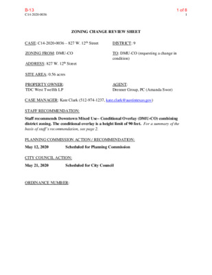
C14-2020-0036 1 ZONING CHANGE REVIEW SHEET CASE: C14-2020-0036 – 827 W. 12th Street DISTRICT: 9 ZONING FROM: DMU-CO ADDRESS: 827 W. 12th Street SITE AREA: 0.56 acres PROPERTY OWNER: TDC West Twelfth LP TO: DMU-CO (requesting a change in condition) AGENT: Drenner Group, PC (Amanda Swor) CASE MANAGER: Kate Clark (512-974-1237, kate.clark@austintexas.gov) STAFF RECOMMENDATION: Staff recommends Downtown Mixed Use– Conditional Overlay (DMU-CO) combining district zoning. The conditional overlay is a height limit of 90 feet. For a summary of the basis of staff’s recommendation, see page 2. PLANNING COMMISSION ACTION / RECOMMENDATION: May 12, 2020 Scheduled for Planning Commission CITY COUNCIL ACTION: May 21, 2020 Scheduled for City Council ORDINANCE NUMBER: 1 of 8B-13 C14-2020-0036 2 ISSUES This property was rezoned from CS to DMU-CO last year (Ordinance No. 20190620-124) which limited the height of buildings to 60 feet. At the time of the previous rezoning case, the applicant had intended to utilize the Downtown Density Bonus Program for increased entitlements. It was unclear at that time that by limiting the building height to 60 feet through a conditional overlay, the CO would prevent the applicant in moving forward with a taller building height even if they fully participated in the Downtown Density Bonus Program. Therefore, in order to construct the building that is currently under review (case # SP-2019-0390C), a zoning change is necessary to increase the maximum allowable building height. The applicant and Neighborhood Association have agreed upon a private restrictive covenant (RC). This private RC lays out terms on what the maximum development entitlements are and how the applicant may earn them. CASE MANAGER COMMENTS: The property is zoned DMU-CO and currently has four buildings located onsite: a commercial retail store, two office/warehouse buildings dedicated to professional reprographics, and one single-family style structure being used as an office. The first three buildings are configured around a parking lot with the single-family style building behind these. This property is on the south side of West 12th Street. Across the street to the north are parcels zoned CS containing the ACC Rio Grande Parking Garage, retail shops and a café. To the east of the property are also CS zoned parcels, containing offices within a mixture of repurposed single- family and modern style structures. To the south and southwest of the property are parcels zoned MF-4, GO and LO. The GO and LO parcels have a mixture of office uses contained within a combination of repurposed single-family and traditional office style buildings, and the MF-4 parcel has a two-story condominium complex built on it. Directly west of the property is a commercial art gallery, see Exhibit A: Zoning Map and Exhibit B: Aerial Map. BASIS OF RECOMMENDATION: 1. The proposed zoning should be consistent with the goals and objectives of the City Council. Last year Council approved Ordinance No. 20191031-037 amending City Code Section 25-2- 586 (Downtown Density Bonus Program) to modify the Downtown Density Bonus Map. This ordinance was to correct a mapping discrepancy for this property at 827 W. 12th Street. The original boundary for the Downtown Density Bonus Program (DDBP) area split this lot with approximately 14,866 square feet (61% of the lot) allowing participation and the remainder not allowing participation. Staff recommended an amendment to the map to include the entire lot within the allowable DDBP area. The Planning Commission and Codes and Ordinance Joint Committee recommended the amendment and Council approved the Ordinance. Granting DMU-CO would allow the applicant to construct a building with increased entitlements that complies with the DDBP. 2 of 8B-13 C14-2020-0036 3 EXISTING ZONING AND LAND USES: Site North South East West Zoning Land Uses DMU-CO Commercial CS (north across W. 12th Street) Educational Facility and Commercial MF-4, LO, GO Multifamily Residential and Office CS CS Office Commercial NEIGHBORHOOD PLANNING AREA: Downtown TIA: The TIA shall be deferred until the time of site plan when final land uses and intensities are known. WATERSHED: Shoal Creek (urban) OVERLAYS: Criminal Justice Center SCHOOLS: Matthews Elementary, O Henry Middle School, Austin High School NEIGHBORHOOD ORGANIZATIONS Austin Independent School District Homeless Neighborhood Association Austin Neighborhoods Council Neighborhood Empowerment Foundation Bike Austin Old Austin Neighborhood Association Central Austin Community Development Preservation Austin City of Austin Downtown Commission SELTexas Downtown Austin Neighborhood Assn. (Dana) Friends of Austin Neighborhoods Historic Austin Neighborhood Association Shoal Creek Conservancy Sierra Club, Austin Regional Group Transwestern Dev. Co. LLC. West Downtown Alliance, Inc 3 of 8B-13 C14-2020-0036 4 AREA CASE HISTORIES: NUMBER REQUEST COMMISSION CITY COUNCIL C14-2017-0077 SF-3 and P to DMU Approved DMU-CO From UNZ and UNZ- H to DMU-CO and DMU-CO-H Approved DMU-CO for Tract 1, and DMU- CO-H for Tract 2 MF-4 to DMU-CO, as amended Approved DMU-CO Approved DMU-CO. CO to limit height to 60 ft, prohibited uses, limit of 2,000 vehicle trips per day Approved DMU-CO for Tract 1, and DMU- CO-H for Tract 2 – CO for 60 ft height limit, prohibited uses, limit of 2,000 vehicle trips per day Approved DMU-CO, CO for 60 ft height limit Austin Community College District 1218 West Ave C14-2017-0076 Acc Rio Grande Campus - Block 153 Zoning 1212 Rio Grande St C14-2016-0110 West House LLC 1005 West Ave 821 West 11th C14-2011-0010 MF-3 to DMU Approved DMU-CO Approved DMU-CO, CO for max height of 40 ft, min front yard setback, prohibited uses, limit of 2,000 vehicle trips per day RELATED CASES: SP-2019-0390C: The applicant is proposing a multi-family development with parking and other associated improvements. C14-2019-0050: to rezone the property from CS to DMU-CO, CO was to limit building height to a maximum of 60 feet in height. EXISTING STREET CHARACTERISTICS: Street ROW Pavement Classification Sidewalks Bike Route Capital Metro (within ¼ mile) Yes Yes W. 12th Street 80’ 52’ 3 Yes 4 of 8B-13 C14-2020-0036 5 OTHER STAFF COMMENTS: Comprehensive Planning The Urban Design staff supports the request for height increase to 90 feet as Ordinance Number 20191031-037 amends City code section 25-2-586 (Downtown Density Bonus) to modify the Downtown Density Bonus Maps, which allows for additional FAR and height increase. Environmental The site is not located over the Edwards Aquifer Recharge Zone. The site is located in the Shoal Creek Watershed of the Colorado River Basin, which is classified as an Urban Watershed by Chapter 25-8 of the City's Land Development Code. Zoning district impervious cover limits apply in the Urban Watershed classification. According to floodplain maps there is a floodplain within or adjacent to the project location. Based upon the location of the floodplain, offsite drainage should be calculated to determine whether a Critical Water Quality Zone exists within the project location. Standard landscaping and tree protection will be required in accordance with LDC 25-2 and 25-8 for all development and/or redevelopment. This site is required to provide on-site water quality controls (or payment in lieu of) for all development and/or redevelopment when 8,000 square feet cumulative is exceeded, and onsite control for the two-year storm. Site Plan Site plans will be required for any new development other than single-family or duplex residential. Additional design regulations will be enforced at the time a site plan is submitted. The subject property is included in an existing site plan application (case # SP-2019-0390C). Downtown Austin Plan The property is subject to the Downtown Austin Plan. Additional comments will be made when the site plan is submitted. Subchapter E: Commercial Design Standards and Mixed Use Any new development is subject to Subchapter E. Design Standards and Mixed Use. Additional comments will be made when the site plan is submitted. Compatibility Standards Per the Downtown Austin Plan’s Proposed Compatibility Zones and Standards, the subject property is identified as a property to be removed from existing compatibility standards within the Land Development Code. Therefore, compatibility standards will not apply when a site plan is submitted. 5 of 8B-13 C14-2020-0036 6 Demolition and Historic Resources The applicant is responsible for requesting relocation and demolition permits once the site plan is approved. The City Historic Preservation Officer will review all proposed building demolitions and relocations prior to site plan approval. If a building meets city historic criteria, the Historic Landmark Commission may initiate a historic zoning case on the property. Justice Center Overlay The property is within the Criminal Justice Center overlay. Please refer to Land Development Code Section 25-2-177. Residential Design Standards Overlay The site is subject to 25-2 Subchapter F. Residential Design and Compatibility Standards. Transportation The Austin Strategic Mobility Plan (ASMP) adopted 04/11/2019, calls for 80 feet of right-of-way for West 12th Street. Existing right-of-way appears sufficient but will be reviewed at the time of site plan. A traffic impact analysis should be deferred until the time of site plan when final land uses and intensities are known. Austin Water Utility The landowner intends to serve the site with City of Austin water, reclaimed, and wastewater utilities in accordance with the approved Service Extension Requests. The landowner, at own expense, will be responsible for providing any water, reclaimed, and wastewater utility improvements, offsite main extensions, utility relocations and or abandonments required by the land use. The water, reclaimed, and wastewater utility plan must be reviewed and approved by Austin Water for compliance with City criteria and suitability for operation and maintenance. Depending on the development plans submitted, water, reclaimed, and or wastewater service extension requests may be required. All water and wastewater construction must be inspected by the City of Austin. The landowner must pay the City inspection fee with the utility construction. The landowner must pay the tap and impact fee once the landowner makes an application for a City of Austin water, reclaimed, and wastewater utility tap permit. INDEX OF EXHIBITS TO FOLLOW Exhibit A: Zoning Map Exhibit B: Aerial Map 6 of 8B-13 SF-3 10 9 8 7 6 SF-3-NP 34 35 27 SF-3-NP E N MF-3-CO-NP SF-3-NP 8 7 9 11 MF-4-NP B N R A M A L N H T 5 1 W O T P M A R B E F I E L 29 D R D MF-3-NP 50 36 37 T L S E HIL MF-3-NP SF-3-NP MF-3-NP 46 59 58 57 38 L T S A C 39 45 44 MF-3-NP SF-3-NP MF-4-NP SF-3-NP 53 52 T R S O L Y A B 64 63 62 1 P-NP H23 GO-NP R A M A L N D V L B 1 SF-3-NP MF-4-NP GO-NP 60 65 P A R K W A Y 2 CS-MU-CO-NP 55 CS-MU-CO-NP 7 1 GO-NP 1 CS-MU-V-CO-NP 2 3 4 5 9 10 11 8 6 1 2 CS-MU-CO-NP CS 12 8 7 MF-5-CO-NP 2 CS-MU-CO-NP 1 CS-MU-V-CO-NP 2 3 4 5 6 8 9 12 11 10 P 1 2 3 6 5 7 1 21 CS-1 18 CS S H O A P 19 20 W 12TH ST 3 4 5 6 7 L C R E E K B L V D GO T RIO E S D N A R G GO 8 7 GO CBD 6 1 2 GO 3 5 4 SF-3 LO-H W 15TH ST SF-3-H SF-3 GO SF-3-H LO-H DMU-H-CO GO-MU-H-CO MF-4 1 LO 2 8 LO 7 2 1 6 GO-H 5 GO 3 4 W 14TH ST 8 7 LO 6 GO 5 W 13TH HALF ST 1 2 3 DMU-CO 4 5 4 3 1 2 P DMU-CO SF-3 MF-4 LO MF-4 E V T A S E W CS J23 DMU-H-CO C14-2020-0036 CS DMU-CO CS CS GO-MU LO UNZ 8 GO 7 5 6 GO 3 4 2 1 LR DMU-CO W 13TH ST 8 GO GO 7 LR-CO 6 GO 5 1 GO 2 3 LR-CO 4 GO 8 1 7 2 6 5 DMU-CO 22 CS-MU-CO-NP 11 12 7A MF-4-NP 10 9 1 2 3 CS-MU-V-CO-NP 1 CS-1-MU-V-CO-NP 7 8 6 9 CS-MU-CO-NP 3 CS 2 1 2 3 13 4 13 10 11 LO 5 CS 8 7 6 MF-4 LO GO 9 DMU-CO A MF-3 B 8 7 W 11TH ST 4 3 LO 2 1 P LO W 10TH ST LO-MU 13 12 11 10 9 8 7 6 5 P GO-MU GO LR-H GO MF-4 7 6 DMU-CO LO 5 1 2 GO 4 3 4 5 CS 6 7 8 9 11 LO-NP 10 3 4 5 SF-3-NP 1 12 13 14 15 16 D V L R B A M A N L 8 9 10 CS-MU-V-CO-NP DMU-CO-CURE 2 3 4 5 7 H22 CS 6 T N S O S R E D N E H 4 CS CS GO 2 MF-4 LO 3 CS-CO CS-CO 6 MF-4 P LO 4 LO 3 1 MF-3 GO W 9TH ST E V T A S E W 1 8 A GO 5 GO-H GO GO 2 A DMU-H 8 7 GO DMU-CO 6 5 1 MF-4 GO 4 LO GO 827 West 12th Street W 12TH ST P 8 7 6 GO 5 DMU-CO T E S D N A R G 1 RIO DMU-H GO 2 3 GO 4 8 7 6 DMU 5 DMU-H 1B DMU 4B 7 8 GO 6 GO-H 5 GO-H GO 2 CS 3 4 T S S E C E U N 1 8 P GO-H 7 6 1 P 2 3 CS W 10TH ST CS 5 4 UNZ 1 T NIO S 5 O T N N A A S P-H 8 7 J22 DMU 6 2 1 DMU-CO 4 3 W 9TH ST 8 7 GO 8 7 MF-4 DMU-CO LO-H 1 DMU 2 3 5B GO 4 LR GO 6 GO 7 5 ± 1'' = 300' SUBJECT TRACT ZONING BOUNDARY ! ! ! ! ! ! PENDING CASE CREEK BUFFER ZONING CASE#: LOCATION: SUBJECT AREA: GRID: MANAGER: C14-2020-0036 827 West 12th Street 0.56 ACRES J23 KATE CLARK This map has been produced by the Communications Technology Management Dept. on behalf of the Planning Development Review Dept. for the sole purpose of geographic reference. No warranty is made by the City of Austin regarding specific accuracy or completeness. 7 of 8B-13 SF-3 10 9 8 7 6 SF-3-NP 34 35 27 SF-3-NP E N MF-3-CO-NP SF-3-NP 8 7 9 11 MF-4-NP B N R A M A L N H T 5 1 W O T P M A R B E F I E L 29 D R D MF-3-NP 50 36 37 T L S E HIL MF-3-NP SF-3-NP MF-3-NP 46 59 58 57 38 L T S A C 39 45 44 MF-3-NP SF-3-NP MF-4-NP SF-3-NP 53 52 T R S O L Y A B 64 63 62 1 P-NP H23 GO-NP R A M A L N D V L B 1 SF-3-NP MF-4-NP GO-NP 60 65 P A R K W A Y 2 CS-MU-CO-NP 55 CS-MU-CO-NP 7 1 GO-NP 1 CS-MU-V-CO-NP 2 3 4 5 9 10 11 8 6 1 2 CS-MU-CO-NP CS 12 8 7 MF-5-CO-NP 2 CS-MU-CO-NP 1 CS-MU-V-CO-NP 2 3 4 5 6 8 9 12 11 10 P 1 2 3 6 5 7 1 21 CS-1 18 CS S H O A P 19 20 W 12TH ST 3 4 5 6 7 L C R E E K B L V D GO T RIO E S D N A R G GO 8 7 GO CBD 6 1 2 GO 3 5 4 SF-3 LO-H W 15TH ST SF-3-H SF-3 GO SF-3-H LO-H DMU-H-CO GO-MU-H-CO MF-4 1 LO 2 8 LO 7 2 1 6 GO-H 5 GO 3 4 W 14TH ST 8 7 LO 6 GO 5 W 13TH HALF ST 1 2 3 DMU-CO 4 5 4 3 1 2 P DMU-CO SF-3 MF-4 LO MF-4 E V T A S E W CS J23 DMU-H-CO C14-2020-0036 CS DMU-CO CS CS GO-MU LO UNZ 8 GO 7 5 6 GO 3 4 2 1 LR DMU-CO W 13TH ST 8 GO GO 7 LR-CO 6 GO 5 1 GO 2 3 LR-CO 4 GO 8 1 7 2 6 5 DMU-CO 22 CS-MU-CO-NP 11 12 7A MF-4-NP 10 9 1 2 3 CS-MU-V-CO-NP 1 CS-1-MU-V-CO-NP 7 8 6 9 CS-MU-CO-NP 3 CS 2 1 2 3 13 4 13 10 11 LO 5 CS 8 7 6 MF-4 LO GO 9 DMU-CO A MF-3 B 8 7 W 11TH ST 4 3 LO 2 1 P LO W 10TH ST LO-MU 13 12 11 10 9 8 7 6 5 P GO-MU GO LR-H GO MF-4 7 6 DMU-CO LO 5 1 2 GO 4 3 4 5 CS 6 7 8 9 11 LO-NP 10 3 4 5 SF-3-NP 1 12 13 14 15 16 D V L R B A M A N L 8 9 10 CS-MU-V-CO-NP DMU-CO-CURE 2 3 4 5 7 H22 CS 6 T N S O S R E D N E H 4 CS CS GO 2 MF-4 LO 3 CS-CO CS-CO 6 MF-4 P LO 4 LO 3 1 MF-3 GO W 9TH ST E V T A S E W 1 8 A GO 5 GO-H GO GO 2 A DMU-H 8 7 GO DMU-CO 6 5 1 MF-4 GO 4 LO GO 827 West 12th Street W 12TH ST P 8 7 6 GO 5 DMU-CO T E S D N A R G 1 RIO DMU-H GO 2 3 GO 4 8 7 6 DMU 5 DMU-H 1B DMU 4B 7 8 GO 6 GO-H 5 GO-H GO 2 CS 3 4 T S S E C E U N 1 8 P GO-H 7 6 1 P 2 3 CS W 10TH ST CS 5 4 UNZ 1 T NIO S 5 O T N N A A S P-H 8 7 J22 DMU 6 2 1 DMU-CO 4 3 W 9TH ST 8 7 Copyright nearmap 2015 GO 8 7 MF-4 DMU-CO LO-H 1 DMU 2 3 5B GO 4 LR GO 6 GO 7 5 ± 1'' = 300' SUBJECT TRACT ZONING BOUNDARY ! ! ! ! ! ! PENDING CASE CREEK BUFFER ZONING CASE#: LOCATION: SUBJECT AREA: GRID: MANAGER: C14-2020-0036 827 West 12th Street 0.56 ACRES J23 KATE CLARK This map has been produced by the Communications Technology Management Dept. on behalf of the Planning Development Review Dept. for the sole purpose of geographic reference. No warranty is made by the City of Austin regarding specific accuracy or completeness. 8 of 8B-13