B-15 (C14-2020-0019 - Church of Christ at East Side, District 1) — original pdf
Backup
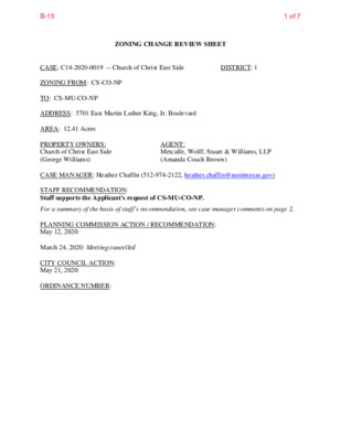
ZONING CHANGE REVIEW SHEET CASE: C14-2020-0019 -- Church of Christ East Side DISTRICT: 1 ADDRESS: 5701 East Martin Luther King, Jr. Boulevard ZONING FROM: CS-CO-NP TO: CS-MU-CO-NP AREA: 12.41 Acres PROPERTY OWNERS: Church of Christ East Side (George Williams) AGENT: Metcalfe, Wolff, Stuart & Williams, LLP (Amanda Couch Brown) CASE MANAGER: Heather Chaffin (512-974-2122, heather.chaffin@austintexas.gov) STAFF RECOMMENDATION: Staff supports the Applicant's request of CS-MU-CO-NP. For a summary of the basis of staff’s recommendation, see case manager comments on page 2. PLANNING COMMISSION ACTION / RECOMMENDATION: May 12, 2020: March 24, 2020: Meeting cancelled CITY COUNCIL ACTION: May 21, 2020: ORDINANCE NUMBER: 1 of 7B-15 ISSUES: There are no issues at this time. The Applicant proposes to add MU- Mixed Use designation to allow development of part of their property with multifamily residential land use. The Applicant does not propose removing or modifying any of the existing conditional overlays (COs) on the property. CASE MANAGER COMMENTS: The proposed rezoning is for a portion of a property located at the southwest corner of the intersection of East Martin Luther King, Jr. Boulevard (MLK) and US Highway 183. Closest to the intersection is the Church of Christ at East Side, with religious assembly land use. The southeastern portion of the property is the area to be rezoned, and is separated by a tributary of Walnut Creek. The rezoning tract is mostly undeveloped and has frontage on US Highway 183 and Tannehill Lane. The property is zoned CS-CO-NP, with COs that were added at the time of the East MLK neighborhood planning process in 2002. In addition to designating the parcel as mixed use on the future land use map (FLUM), the plan added the following prohibited land uses: adult oriented businesses, automotive sales, blood plasma collection center, convenience storage, equipment sales, vehicle storage, agricultural sales and services, campgrounds, construction sales and services, equipment repair services, kennels, and limited warehousing and distribution land uses. The Applicant does not propose modifying the existing CO. Immediately south of the rezoning tract is land zoned CS-CO-NP with the same conditions as the rezoning tract that is developed with a civic use. Further south are properties developed with religious assembly and multifamily land uses that are zoned MF-2-CO-NP. Across Tannehill Lane to the west are an undeveloped tract (GR-CO-NP) and multifamily land use (MF-3-CO- NP). Southwest of the rezoning tract are religious assembly and private education land uses zoned SF-3-NP. Across MLK Boulevard to the north are a single family neighborhood and a public education land use zoned SF-2-NP and CS-CO-NP. Across US Highway 183 to the east are limited restaurant land use and undeveloped properties with a mix of commercial and limited industrial zoning. Please see Exhibits A and B—Zoning Map and Aerial Exhibit. Staff supports the Applicant’s request to add the MU designation to the existing zoning on the subject tract. The neighborhood plan supports mixed use at this location, which includes multifamily development. The location is close to community services, including educational and religious assembly. There is an existing bike lane and sidewalks along Tannehill Lane, as well as Capital Metro bus service. Development of this property with residential units will increase available housing options for the area. BASIS OF RECOMMENDATION: 1. sought. The proposed zoning should be consistent with the purpose statement of the the district Adding the MU designation will match the neighborhood plan and allow multifamily development. 2. The proposed zoning should promote compatibility with adjacent and nearby land uses. Multifamily land use is compatible with the surrounding civic, religious assembly, educational, and residential land uses. 3. Council. The proposed zoning should be consistent with the goals and objectives of the City 2 of 7B-15 Allowing multifamily development of this vacant property will help meet the goals of the Strategic Housing Blueprint. EXISTING ZONING AND LAND USES: Site North CS-CO-NP, SF-2-NP, CS-CO- CS-CO-NP ZONING South CS-CO-NP, MF-2-CO-NP East CS-NP, LI-CO-NP, CS-CO-NP, CS-MU-CO-NP West GR-CO-NP, MF-3-CO-NP, SF- NP 3-NP LAND USES Undeveloped Religious assembly, Single family residential, public educational facility (K-12) Civic, Religious assembly, Multifamily residential Undeveloped, Equipment sales, Restaurant (limited) Undeveloped, Multifamily residential, Religious assembly, Private educational facility (K-12) NEIGHBORHOOD PLANNING AREA: MLK-183 Combined TIA: N/A WATERSHED: Walnut Creek NEIGHBORHOOD ORGANIZATIONS: Bike Austin Homeless Neighborhood Association AISD Austin Neighborhoods Council Del Valle Community Coalition Neighborhood Empowerment Foundation East MLK Combined Neighborhood Contact Team AREA CASE HISTORIES: NUMBER C14-2020-0017 MLK & 183 Residential EXISTING STREET CHARACTERISTICS: REQUEST CS-NP and LI-CO-NP to CS-MU-NP COMMISSION TBD Friends of Northeast Austin Sierra Club SELTexas Neighbors United for Progress CITY COUNCIL TBD 3 of 7B-15 OTHER STAFF COMMENTS: COMPREHENSIVE PLANNING East MLK Neighborhood Plan The East MLK Plan Future Land Use Map classifies this property, which is located in the Martin Luther King area, as Mixed Use. The Mixed Use Future Land Use Category permits multifamily residential units. The Mixed Use Future Land Use category is an area appropriate for a mix of residential and non-residential uses. The following East MLK Plan policies and text are applicable to this request, including text and recommendation taken from the East MLK design guidelines: OBJECTIVE 2: Design multi-family residential projects to be compatible with adjacent single- family areas. (pgs 24 – 25) Land Use Goal One - Preserve established residential areas and improve opportunities for home ownership by promoting the rehabilitation of existing housing and new, infill housing compatible with the existing style of this neighborhood. (p. 44) Objective 1.1: Maintain single-family zoning in established residential areas. Objective 1.2: Promote new infill housing in appropriate locations. Goal 4 - Promote the development and enhancement of the neighborhood’s major corridors. Objective 4.1: Allow mixed use development along major corridors and intersections. Goal Five - Provide housing that helps maintain the social and economic diversity of residents. Objective 5.1: Allow a mix of residential types on larger tracts having access to major roadways. encroachment into existing or planned residential areas. ENVIRONMENTAL 1. The site is not located over the Edwards Aquifer Recharge Zone. The site is in the Walnut Creek Watershed of the Colorado River Basin, which is classified as a Suburban Watershed by Chapter 25-8 of the City's Land Development Code. 2. Under current watershed regulations, development or redevelopment on this site will be subject to the following impervious cover limits: 3. According to floodplain maps there is no floodplain within or adjacent to the project location. 4. Standard landscaping and tree protection will be required in accordance with LDC 25-2 and 25-8 for all development and/or redevelopment. 5. Trees will likely be impacted with a proposed development associated with this rezoning case. Please be aware that an approved rezoning status does not eliminate a proposed development’s requirements to meet the intent of the tree ordinances. If further explanation or specificity is needed, please contact the City Arborist at 974-1876. At this time, site specific information is unavailable regarding other vegetation, areas of steep slope, or other environmental features such as bluffs, springs, canyon rimrock, caves, sinkholes, and wetlands. 4 of 7B-15 6. This site is required to provide on-site water quality controls (or payment in lieu of) for all development and/or redevelopment when 8,000 s.f. cumulative is exceeded, and on site control for the two-year storm. SITE PLAN SP 1. Site plans will be required for any new development other than single-family or duplex residential. SP 2. Any new development is subject to Subchapter E. Design Standards and Mixed Use. Additional comments will be made when the site plan is submitted. TRANSPORTATION The TIA Determination has been deferred to time of site plan when development intensities are determined. WATER UTILITY 1. The landowner intends to serve the site with City of Austin water and wastewater utilities. The landowner, at own expense, will be responsible for providing any water and wastewater utility improvements, offsite main extensions, utility relocations and or abandonments required by the land use. Water and wastewater utility plans must be reviewed and approved by the Austin Water Utility for compliance with City criteria. All water and wastewater construction must be inspected by the City of Austin. The landowner must pay the City inspection fee with the utility construction. The landowner must pay the tap and impact fee once the landowner makes an application for a City of Austin water and wastewater utility tap permit. INDEX OF EXHIBITS TO FOLLOW A: Zoning Map B. Aerial Exhibit 5 of 7B-15 ( ( SF-2-NP ( ( ( ( ( ( ( SF-2-NP ( ( ( ( ( R L D T HIL ( ( ( ( E S S U R ( ( ( ( ( ( ( ( ( ( ( ( ( ( ( ( ( SF-2-NP ( ( ( ( ( R L D K HIL ( ( ( ( ( ( SF-2-NP ( ( ( ( ( R O Y ( ( ( ( ( ( ( ( ( R E D L A D L HIL ( ( ( ( ( ( ( ( ( ( ( ( SF-2-NP ( ( ( ( ( ( ( ( ( ( ( ( ( ( ( ( ( ( ( ( ( ( ( ( SF-2-NP ( ( N O RTH C14-04-0131 SF-4A-NP ( ( ( ( ( ( ( ( ( DALE D R ( ( CS-NP ( ( ( R E D L A D ( T S A E ( ( ( ( ( ( SF-2-NP ( ( ( ( ( ( ( ( SP94-0400C 02-01 42.001 78-64 CS-CO-NP 73-157 73-157 C 0 0 4 0 - 4 9 P S SP94-0400C 73-26 C14-95 -0179 95-0179 E MARTIN LUTHER KING JR BLVD MILLWORK SF-3-NP R86-200 0 1 - 0 1 8 7 . S H 02-0142.002 02-0142.002 GR-CO-NP 02-0142.002 02-0142.002 ! ! ! ! HILL LN ! ! E N N TA ! ! ! ! ! ! CS-CO-NP ! ! ! ! ! ! ! ! ! ! VACANT UNDEV 02-142.002 ! SP-2007-0486C ! ! ! ! VACANT ! ! CS-CO-NP ! ! ! ! ! ! ! ! ! ! ! ! ! ! ! ! ! ! ! VACANT MF-3-CO-NP C14-01-0187.SH SP-03-0124C.SH 01-0187.SH ( ( ( ( ( SF-3-NP W E B B E R V I L L E R D = VACANT SF-3-NP 02-0142.002 SP-05-1216C 02-0006.SH C14-02-0006.SH TR A C O R LN MF-2-CO-NP 99-0047 C14-99-0047 CS-CO-NP SF-2-NP CS-CO-NP 02-0142.002 B S D R V S D V L B N I E T S E U L B D E B S D V L B N I E T S E U L B D E B N D V L B N I E T S E U L B D E B D N R V D S V L EIN B T S E U L D B E CS-MU-CO-NP C14-2007-0049 FM 969 RD ( ! ! ! ! ! ! ! ! ! ! ! ! ! ! ! ! ! ! ! ! ! ! C14-75-126(B)(RCT) ! ! ! ! UNDEV ! ! ! ! C14-2007-0134 ! ! ! ! ! ! CS-NP ! ! ! ! ! ! ! ! ! ! ! ! ! ! ! ! ! ! ! ! ! ! ! ! SF-3-NP ( M AR CEL G RES DR LI-NP T R A C O R L N SUBJECT TRACT ! ! ! ! ! ! PENDING CASE ZONING BOUNDARY CS-NP ZONING ZONING CASE#: C14-2020-0019 This product is for informational purposes and may not have been prepared for or be suitable for legal, engineering, or surveying purposes. It does not represent an on-the-ground survey and represents only the approximate relative location of property boundaries. 1 " = 400 ' This product has been produced by CTM for the sole purpose of geographic reference. No warranty is made by the City of Austin regarding specific accuracy or completeness. Created: 2/14/2020 ( ( ( ( P-NP ± 6 of 7B-15 K R R L D O Y HIL SF-2-NP E MARTIN LUTHER KING JR BLVD R E D L A D L HIL SF-2-NP SF-2-NP R E D L A D T S A E M24 CS-CO-NP E MARTIN LUTHER KING JR BLVD SF-3-NP GR-CO-NP FM 969 RD HILL LN E N N TA C14-2020-0019 MF-3-CO-NP W E B B E R V I L L E R D CS-CO-NP SF-3-NP M23 CS-CO-NP CS-NP N I E T S E U L B D E B S D R V S D V L B B M P T E I N S A K W B R S E N24 U L E L D B O M T B L U E M E S T L O K T E E E S D B B R A M P B S D V L B N I E T S E U L B D E B N D V L B N I E T S E U L B D E B EIN D N T S R E V U D S L D B V L E B I N E T S E U L B D E B S D R V S D V L B N23 CS-NP MARCEL GRES DR LI-NP Copyright nearmap 2015 N L L HIL E N N TA ± 1'' = 300' MF-2-CO-NP TR A C O R LN CHURCH OF CHRIST AT EAST SIDE C14-2020-0019 Creek Buffers ZONING BOUNDARY ZONING CASE#: LOCATION: SUBJECT AREA: GRID: MANAGER: C14-2020-0019 5701 E. MLK 12.41 Acres M23 Heather Chaffin This map has been produced by the Communications Technology Management Dept. on behalf of the Planning Development Review Dept. for the sole purpose of geographic reference. No warranty is made by the City of Austin regarding specific accuracy or completeness. 7 of 7B-15