B-10 (C14-2019-0167 - 4530 E. Ben White Blvd; District 3_ — original pdf
Backup
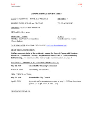
C14-2019-0167 1 ZONING CHANGE REVIEW SHEET CASE: C14-2019-0167 – 4530 E. Ben White Blvd DISTRICT: 3 ZONING FROM: SF-2-NP and CS-CO-NP TO: CS-MU-CO-NP ADDRESS: 4530 East Ben White Blvd SITE AREA: 12.44 acres PROPERTY OWNER: 4530 East Ben White Associates LLC (Trevor Belton) AGENT: Coats Rose (John Joseph) CASE MANAGER: Kate Clark (512-974-1237, kate.clark@austintexas.gov) STAFF RECOMMENDATION: Staff recommends denial of the applicant’s request for General Commercial Services – Mixed Use – Conditional Overlay – Neighborhood Plan (CS-MU-CO-NP) combining district zoning. For a summary of the basis of staff’s recommendation, see page 3. PLANNING COMMISSION ACTION / RECOMMENDATION: May 12, 2020 Scheduled for Planning Commission March 24, 2020 This meeting was canceled. CITY COUNCIL ACTION: May 21, 2020 Scheduled for City Council April 9, 2020 Approved staff’s postponement request to May 21, 2020 on the consent agenda. (11-0). [K. Tovo, P. Ellis – 2nd]. ORDINANCE NUMBER: 1 of 19B-10 C14-2019-0167 2 ISSUES This property is located in the East Riverside/Oltorf Combined Neighborhood Plan (Parker Lane) and is currently identified as “commercial” on the future land use map (FLUM). The owner is requesting to change the FLUM to “mixed use” in order to construct a multifamily building. There is an existing neighborhood plan amendment (NPA) associated with this rezoning case (NPA-2017-0021.01). The owner has been working with the neighborhood plan contact team to come to an agreement with them in order to support of the FLUM change and rezoning of the property, see Exhibit C: NPA and Owner Agreement. Most of the items within the agreement will be incorporated into a private restrictive covenant. The only item within their agreement related to this rezoning case is a list of prohibited uses. The property is subject to a previous ordinance from 2000 (ordinance number: 000511-67) which included an extensive list of prohibited uses. The owner and neighborhood contact team have mutually agreed to carry over the exiting prohibited uses with this rezoning case: Agricultural Sales and Service Automotive Rentals Automotive Repair Services Automotive Sales Automotive Washing (of any type) Building Maintenance Services Campground Club or Lodge Commercial Off-Street Parking Communication Service Facilities Community Recreation (private) Community Recreation (public) Construction Sales and Service Convenience Storage Counseling Services Custom Manufacturing Drop-Off Recycling Collection Facility Employee Recreation (non-profit) Equipment Repair Services Equipment Sales Funeral Services Indoor Entertainment Indoor Sports and Recreation Kennels Laundry Services Local Utility Services Maintenance and Service Facilities Monument Retail Sales Outdoor Entertainment Outdoor Sports and Recreation Pawn Shop Services Pet Services Residential Treatment Safety Services Scrap and Salvage Theater Transitional Housing Transportation Terminal Vehicle Storage Veterinary Services There are no land uses included in this list that were not part of the original ordinance from 2000. If rezoning is approved, staff is recommending that the following uses be removed from this list for the following reasons: • Counseling Services: is the use of a site for the provision of daytime counseling to neglected or abused children, 15 years of age or younger, or their managing conservators, who are referred by a governmental entity or other counseling service providers. 2 of 19B-10 C14-2019-0167 3 • Local Utility Services: this use cannot be prohibited or made conditional due to the potential to impede City’s ability to place small utility poles and structures on property. • Scrap and Salvage: this use is not permitted in CS base zoning; staff does not recommend prohibiting a use that would not be allowed anyway. CASE MANAGER COMMENTS: This property is located on the north side of E. Ben White Blvd along the westbound service road. It is undeveloped, approximately 12.44 acres in size and is primarily zoned CS-CO-NP combining district zoning with a small strip of SF-2-NP combining district zoning on the western and northern boundaries. The owner is requesting to add mixed use (MU) to their zoning to allow for multifamily uses. Adjacent to the north of the property is the Country Club Creek Greenbelt, it is zoned SF-2-NP. Directly east of the property is a tract zoned GO-CO-NP which houses the Saint Peter Apostle Church and associated buildings. South of the property is E. Ben White Blvd. with a combination of P-NP and LI-NP south of E. Ben White Blvd. Adjacent to the west are properties zoned LO- CO-NP and SF-2-NP, both of which are undeveloped. Due to the existing greenbelt to the north and environmental features (floodplain and potential creek buffer) to the west, development on this property would have a natural buffer between it and the existing SF-2-NP zoned properties, see Exhibit A: Zoning Map and Exhibit B: Aerial Map. BASIS OF RECOMMENDATION: 1. Zoning changes should promote compatibility with adjacent and nearby uses. This property is located in southeast Austin near a predominately industrial area. The applicant is requesting CS-MU-CO-NP to allow for residential units (multifamily) to be permitted as a use on the property. Scott Stookey from the Austin Fire Department (AFD) has reviewed the site and its immediate surrounding area for hazardous materials. His assessment found hazardous materials on properties within 2,000 feet of the site. Two of the three risks meet recommended distance separation. One of the risks (Anhydrous Chlorine) does not meet the separation distance. Due to the risk assessment report, it was determined that allowing multifamily housing on this site would not be compatible with existing land uses. AFD’s comments and risk assessment are included within Exhibit D: AFD Hazardous Materials Assessment. EXISTING ZONING AND LAND USES: Site North South Zoning Land Uses SF-2-NP and CS-CO-NP Undeveloped SF-2-NP Country Club Creek Greenbelt NA (E. Ben White Blvd.) Transportation (Highway) 3 of 19B-10 C14-2019-0167 4 East West Zoning Land Uses GO-CO-NP Church LO-CO-NP and SF-2-NP Undeveloped NEIGHBORHOOD PLANNING AREA: East Riverside/Oltorf Combined (Parker Lane) TIA: is deferred until site plan submittal. WATERSHED: Country Club West (Suburban) OVERLAYS: Residential Design Standards and Scenic Roadways (SH 71). SCHOOLS: Del Valle ISD - Smith Elementary, Ojeda Middle and Del Valle High Schools. NEIGHBORHOOD ORGANIZATIONS Austin Independent School District Austin Neighborhoods Council Bike Austin Burleson Road Heights Neighborhood Crossing Gardenhome Owners Assn. (The) Del Valle Community Coalition Del Valle Independent School District Dove Springs Proud Friends of Austin Neighborhoods Go Austin! Vamos Austin! 78744 AREA CASE HISTORIES: Homeless Neighborhood Association Neighborhood Empowerment Foundation Onion Creek Homeowners Assoc. Pleasant Valley Preservation Austin SELTexas Sierra Club, Austin Regional Group Southeast Austin Neighborhood Alliance Southeast Combined Neighborhood Plan Sunridge Homeowners Assn. Number Request Commission City Council C14-2016-0069 5016-1/2 E Ben White Blvd Service Road Westbound CS-CO-NP and GR- CO-NP to CS-MU- CO-NP and GR-MU- CO-NP Approved CS-CO-NP for Tract 1; CS-MU- CO-NP for Tract 2 and GR-MU-CO-NP for Tract 3 w/ additional conditions. Approved Planning Commission recommendation with additional conditions. 4 of 19B-10 C14-2019-0167 5 Number Request Commission City Council C14-2013-0106 GR-NP to CS-CO-NP Approved CS-CO-NP (Tract 1) and GR- CO-NP (Tract 2). Approved CS-CO-NP (Tract 1) and GR- CO-NP (Tract 2). C14-05-0111 SF-2 to GO-CO-NP Approved GO-CO- NP. Approved GO-CO- NP. 5016-1/2 E Ben White Blvd Service Road Westbound 4600, 4604 E. Ben White Blvd. (Tract 222) to amend Parker Lane neighborhood plan combining district to add properties. C14-97-0018 4818 E Ben White Blvd. RELATED CASES: SF-2 and GR to GR- CO Approved GR-CO. Approved GR-CO. C14-99-2108: rezoning from SF-2 to CS-CO. Conditional overly prohibited a set of land uses, limiting height of buildings to 636 feet above sea level and a maximum of 2,000 trips per day, Ordinance No. 000511-67. East Riverside/Oltorf Combined Neighborhood Plan (Parker Lane Neighborhood Planning Area), NPA Ordinance No. 20061116-055. EXISTING STREET CHARACTERISTICS: Street ROW Pavement Classification Sidewalks Bike Route Capital Metro yes no no (within ¼ mile) E Ben White 360’ 335’ (Divided) Level 5 5 of 19B-10 C14-2019-0167 6 OTHER STAFF COMMENTS: Environmental The site is not located over the Edwards Aquifer Recharge Zone. The site is in the Country Club West Watershed of the Colorado River Basin, which is classified as a Suburban Watershed by Chapter 25-8 of the City's Land Development Code (LDC). Under current watershed regulations, development or redevelopment on this site will be subject to the following impervious cover limits: Development Classification % of Gross Site Area % of Gross Site Area with Transfers Single-Family (minimum lot size 5750 sq. ft.) 50% Other Single-Family or Duplex 55% Multifamily Commercial 60% 80% 60% 60% 70% 90% According to floodplain maps there is a floodplain within or adjacent to the project location. Based upon the location of the floodplain, offsite drainage should be calculated to determine whether a Critical Water Quality Zone exists within the project location. Standard landscaping and tree protection will be required in accordance with LDC 25-2 and 25-8 for all development and/or redevelopment. At this time, site specific information is unavailable regarding vegetation, areas of steep slope, or other environmental features such as bluffs, springs, canyon rimrock, caves, sinkholes, and wetlands. Under current watershed regulations, development or redevelopment requires water quality control with increased capture volume and control of the 2-year storm on site. Site Plan Site plans will be required for any new development other than single-family or duplex residential. Any development which occurs in an SF-6 or less restrictive zoning district which is located 540 feet or less from property in an SF-5 or more restrictive zoning district will be subject to compatibility development regulations. Any new development is subject to Subchapter E. Design Standards and Mixed Use. Additional comments will be made when the site plan is submitted. Additional design regulations will be enforced at the time a site plan is submitted. Compatibility Standards The site is subject to compatibility standards due to proximity and adjacency of SF-2-NP zoning to the west and north. The following standards apply: 6 of 19B-10 C14-2019-0167 7 • No structure may be built within 25 feet of the property line to west and north. • No structure in excess of two stories or 30 feet in height may be constructed within 50 feet of the property line. feet of the property line. north. • No structure in excess of three stories or 40 feet in height may be constructed within 100 • No parking or driveways are allowed within 25 feet of the property line to the west and • Landscaping or screening is required along the west and north property lines in accordance with the screening requirements (Section 25-2-1006 and ECM 2.9.1.), Parking Design Standards (Section 25-6-563) and/or Screening Standards (Section 25.2.1066) to screen adjoining properties from views of parking, mechanical equipment, storage, and refuse collection. • For a structure more than 100 feet but not more than 300 feet from property zoned SF-5 or more restrictive, height limitation is 40 feet plus one foot for each 10 feet of distance in excess of 100 feet from the property zoned SF-5 or more restrictive. • For a structure more than 300 feet but not more than 540 feet from property zoned SF-5 or more restrictive, 60 feet plus one foot for each four feet of distance in excess of 300 feet from the property zoned SF-5 or more restrictive. • An intensive recreational use, including a swimming pool, tennis court, ball court, or playground, may not be constructed 50 feet or less from property in an SF-5 or more restrictive zoning district. • A landscape area at least 25 feet in width is required along the property line if the tract is zoned LR, GO, GR, L, CS, CS-1, or CH. Scenic Roadways A portion of this site is within the Scenic Roadway Sign District. All signs must comply with Scenic Roadway Sign District regulations. Contact Viktor Auzenne at (512) 974-2941 for more information. Demolition and Historic Resources The applicant is responsible for requesting relocation and demolition permits once the site plan is approved. The City Historic Preservation Officer will review all proposed building demolitions and relocations prior to site plan approval. If a building meets city historic criteria, the Historic Landmark Commission may initiate a historic zoning case on the property. 7 of 19B-10 C14-2019-0167 8 Residential Design Standards Overlay This site is within the Parker Lane Neighborhood Planning Area. The site is subject to 25-2 Subchapter F. Residential Design and Compatibility Standards. Transportation At the time of submittal of any site plan on the Property, a traffic impact analysis (TIA) is required if the proposed development or uses on the Property, considered cumulatively with all existing or previously authorized development and uses, generates traffic that exceeds 2,000 trips per day. Austin Water Utility The landowner intends to serve the site with City of Austin water utilities and an On-Site Sewage Facility. The landowner, at own expense, will be responsible for providing any water and wastewater utility improvements, offsite main extensions, utility relocations and or abandonments required by the land use. The water and wastewater utility plan must be reviewed and approved by Austin Water for compliance with City criteria and suitability for operation and maintenance. City wastewater service is not currently available to serve this tract. If service is desired, a Service Extension Request (SER) will need to be approved. For more information pertaining to the SER process and submittal requirements contact Alberto Ramirez with Austin Water, Utility Development Services at 625 E. 10th St., 7th floor, phone 512-972-0211. Austin Water reserves the right to make additional comments and to establish other requirements with the SER review. Depending on the development plans submitted, water and or wastewater service extension requests may be required. All water and wastewater construction must be inspected by the City of Austin. The landowner must pay the City inspection fee with the utility construction. The landowner must pay the tap and impact fee once the landowner makes an application for a City of Austin water and wastewater utility tap permit. INDEX OF EXHIBITS TO FOLLOW Exhibit A: Zoning Map Exhibit B: Aerial Map Exhibit C: NPA and Owner Agreement Exhibit D: AFD Hazardous Materials Assessment 8 of 19B-10 28 27 26 25 23 24 22 21 19 20 18 7 SF-2-NP R I D 14 N U 13 S 12 SF-2-NP 6 8 7 11 10 9 2 E D G 15 R 1 2 3 4 5 21 22 23 24 25 26 27 28 4 5 3 6 7 29 30 R N D O LLIS 32 31 A 33 34 35 1 MF-2-NP WIC K E R S 17 16 15 14 H A M L N 13 12 8 9 11 10 1 2 SUNRIDGE CT 6 5 4 17 16 15 14 13-A 8 9 1A 2A 12-A 10 11 3 2 3A 4A 8A 7A 5A 6A K18 9A 10A 11A 12A 37 36 38 39 SF-2-NP 1 GR-MU-CO-NP LI-NP 17 1A 29 15 19 20 16 18 17 1 MF-2-NP 2A 3 A 4 R A A D 17 16 15 14 5 6 7 8 A S T N N I C 1 9 10 13 12 11 M 1 20 O 2 SF-3-NP 18 3 4 SF-3-NP 5 6 7 8 9 15 SF-3-NP MH-NP 1 2 3 1 TERRILANCE DR 7 2-A 1 2 8 7 1-A 2-A SF-3-NP 2 3 1 D R N O S E L R U B 6 5 6 5 T N D A Y R S A E E L L L S P A V 4 4 3 3 SF-3-NP 2 1 J18 MF-3 1-A MF-2 LR P-NP SF-3-NP MISSION HILL DR MF-3 GR-NP 1 GR-NP 1 2 LO-CO-NP A 1 CS-CO-NP C 14-2019-0167 1 1 E BEN WHITE BLVD WB E BEN WHITE BLVD SVRD WB E BEN WHITE EB TO CHAPMAN RAMP LI-NP E BEN WHITE BLVD EB E BEN WHITE BLVD SVRD EB 1 A 1 GR-CO-NP ALVIN DEVANE TO BEN WH WB RAMP 2 LI-NP 1 P-NP J17 2 B U RLE S O N R D 1 2 1 2 LI-NP 1-B 1-A CS-1-CO-NP 2 GO-CO-NP 1 CS-MU-CO-NP 4 LI-NP SF-2-NP E BEN WHITE BLVD WB A B D 2 3 A C N N L A M P A H C 4 K17 1 A LI-NP 6 7 8 18 5 9 10 1 19 20 SUBJECT TRACT ZONING BOUNDARY ! ! ! ! ! ! PENDING CASE CREEK BUFFER 1 LI-NP 4530 E Ben White Blvd Zoning ZONING CASE#: LOCATION: SUBJECT AREA: GRID: MANAGER: C14-2019-0167 4530 E Ben White Blvd 12.4 ACRES J18 KATE CLARK This map has been produced by the Communications Technology Management Dept. on behalf of the Planning Development Review Dept. for the sole purpose of geographic reference. No warranty is made by the City of Austin regarding specific accuracy or completeness. 1 2 ± 1'' = 400' 9 of 19B-10 17 1A 29 15 19 20 16 18 17 1 MF-2-NP 2A 3 A 4 R A A D 17 16 15 14 5 6 7 8 A S T N N I C 1 9 10 13 12 11 M 1 20 O 2 SF-3-NP 18 3 4 SF-3-NP 5 6 7 8 9 15 SF-3-NP MH-NP 1 2 3 1 TERRILANCE DR 7 2-A 2 1 8 7 1-A 2-A SF-3-NP 2 3 1 D R N O S E L R U B 6 5 6 5 T N D A Y R S A E E L L L S P A V 4 4 3 3 SF-3-NP 2 1 J18 MF-3 1-A MF-2 LR P-NP SF-3-NP MISSION HILL DR MF-3 GR-NP 1 GR-NP 1 2 LO-CO-NP A 28 27 26 25 23 24 22 21 19 20 18 7 SF-2-NP R I D 14 N U 13 S 12 SF-2-NP 6 8 7 11 10 9 2 E D G 15 R 1 2 3 4 5 21 22 23 24 25 26 27 28 4 5 3 6 7 29 30 R N D O LLIS 32 31 A 33 34 35 1 MF-2-NP WIC K E R S 17 16 15 14 H A M L N 13 12 8 9 11 10 1 2 SUNRIDGE CT 6 5 4 17 16 15 14 13-A 8 9 1A 2A 12-A 10 11 3 2 3A 4A 8A 7A 5A 6A K18 9A 10A 11A 12A 37 36 38 39 SF-2-NP 1 GR-MU-CO-NP LI-NP 1 CS-CO-NP C 14-2019-0167 1 1 GO-CO-NP 1 CS-MU-CO-NP 4 LI-NP SF-2-NP E BEN WHITE BLVD WB E BEN WHITE BLVD SVRD WB E BEN WHITE EB TO CHAPMAN RAMP LI-NP E BEN WHITE BLVD EB E BEN WHITE BLVD SVRD EB 1 A 1 GR-CO-NP ALVIN DEVANE TO BEN WH WB RAMP E BEN WHITE BLVD WB A B D 2 3 A C N N L A M P A H C 4 K17 1 A LI-NP 1 2 LI-NP 1-B 1-A CS-1-CO-NP 2 2 LI-NP 1 P-NP J17 2 B U RLE S O N R D 1 2 6 7 8 18 5 9 10 1 Copyright nearmap 2015 19 20 SUBJECT TRACT ZONING BOUNDARY ! ! ! ! ! ! PENDING CASE CREEK BUFFER 1 LI-NP 4530 E Ben White Blvd Zoning ZONING CASE#: LOCATION: SUBJECT AREA: GRID: MANAGER: C14-2019-0167 4530 E Ben White Blvd 12.4 ACRES J18 KATE CLARK This map has been produced by the Communications Technology Management Dept. on behalf of the Planning Development Review Dept. for the sole purpose of geographic reference. No warranty is made by the City of Austin regarding specific accuracy or completeness. 1 2 ± 1'' = 400' 10 of 19B-10 t JOI!:-! M.JOSl,MI DIRHC'fOl'l COATS ROSE A PROFESSION.AL CORPORATION J:-.tJOSl·J'I l@CO,H SIIOSH.C.-0:\t l)uu ;cr: (512) 541-359.l FAX: (51:!) 469,!>408 August 30, 2019 VIA EMAIL: mv«!altsr,i'.mstin.rr.com East Riverside/Oltorf Neighborhood Plan Contact Team {"Team") C/0 Malcolm Yeatts Re: Neighborhood Plan Amendment Case No. NPA-2017-0021.01 Address: 4530 E. Ben White Blvd., Austin, TX 78741 Dear Malcolm: As you know l represent. 4530 East Ben White Associates, LLC {''Owner"), the owner of the above referenced property and am representing it in the pending Neighborhood Plan Amendment I am providing this communication to you in an effort to outline an agreement between the Neighborhood Contact Team and Owner to secure the support of the Neighborhood Contact Team for the Neighborhood Plan Amendment and a concurrent zoning application to add "mixed use" to the cunent zoning, remove certain compatibility restrictions, add some pennitted uses and set out a process for the conveyance of 1.1 acres for the purpose of a public hike and bike trail/Recreational Use Easement The following offer is an outline of a possible agreement. Owner's Commitments 1. To allow the filing of the appropriate documentation conveying a non-exclusive easement, upon final approval of an ordinance fulfilling No. 2 below, of an approximate 1.1 acres site for a multi-purpose hike and bike trail along the north and west property boundary of the subject tract to the East Riverside/Oltorf Neighborhood Association (ERONA and EROC), as shown on the attached Exhibit ··A". 2. Change the zoning of the property to CS-MU to allow between 36 and 54 units per acre of market rate residential rental properties allowing up to 5% of the units to be offered to families at 60% or less median family income, with height limited to 4 stories or 60 feet. 3. Support the amendment of the prohibited uses in Ordinance No. 000511-67 (Exhibit "B") lo the following: 8,\11:1'0:-. 0A"5 PIN.A, ~1 s. MOl'AC H~, 'IV'f, Kux; 1, Sm 500, Ausnx. T EL\S 78746 PIIO!,,.F: ($12) 469.7')R7 FAX: (512) 4(,'),940!! coac:ros,.cum Hom,'ToN I AusnN I D ,•\LLAS I SAN ANTONIO I Nllw ORJ.JiANs I CINCINNATI 4820-8138-7682.vl 11 of 19B-10 August 30, 2019 Page2 Agricultural Sales and Service Automotive Rentals Automotive Repair Services Automotive Sales Automotive Washing (of any type) Campground Commercial Off-Street Parking Construction Sales and Service Drop-Off Recycling Collection Facility Equipment Sales Equipment Repair Services Funeral Services Indoor Sports and Recreation Laundry Services Monwnent Retail Sales Custom Manufacturing Community Recreation (private) Employee Recreation (non-profit) Local Utility Services Residential Treatment Transitional Housing Outdoor Entertainment Outdoor Sports and Recreation Pawn Shop Services Building Maintenance Services Pet Services 4820-8138-7682.vl -------- 12 of 19B-10 August 30, 2019 Page3 Convenience Storage Theater Vehicle Storage V cterinary Services Indoor Entertainment Kennels Scrap and Salvage Club or Lodge Communication Service Facilities Community Recreation (public) Counseling Services Maintenance and Service Facilities Safety Services Transportation Tenninal 5. 6. 4. As long as the same can be accomplished without the necessity for a formal site development pennit application, make application to the City seeking the appropriate variances necessary to allow for the construction of a multi-purpose hike and bike trail along the north and west property boundary of the subject tract. Make application for the waiver of compatibility standards along the east boundary of the property to allow for development within 25 feet of the east property line with a height limited to 4 stories or 60 feet restriction contained in zoning Ordinance No. 000511-67. Make application for the removal, or satisfactory amendment, of the compatibility 7. Make application for the removal of Note No. 2 on the Burleson-Ben White Subdivision Plat (Doc. No. 20010028) that states, .. Development of this property is restricted to uses other than residential", (Exhibit "C"). 8. Place in escrow, with an agreed upon title company or other escrow acceptable to the Owner and ERONA and EROC, the multi-purpose hike and bike trail easement upon the delivery to the agreed upon title company or other escrow acceptable to the Owner and ERONA 4820-8138-7682.vl 13 of 19B-10 August 30, 2019 Page4 and EROC, of the signed agreement with the neighborhood and official resolution of the East Rivcrside/OltorfNeighborhood Plan Contact Team. 9. To dedicate, by appropriate means of conveyance, the easement referenced above upon the approval of the requested zoning, variances and the waiver of compatibility, whichever occurs last in time. East Riverside/OltorfNeighborhood Plan Contact Team Commitments. 1. 2. To consider, approve, execute and deliver to the title company the agreement. To support the pending Neighborhood Plan Amendment to Mixed Use. 3. To support a zoning application to change the current :zoning to (either add "MU - mixed use" or change the current zoning to MF-4 with height limited to four (4) stories or sixty (60') feel 4. To support the amendment of the prohibited uses listed in Ordinance No. 000511- 67. 5. To support the removal of Note No. 2 on the Burleson-Ben White Subdivision Plat (Doc. No. 20010028) that states, "Development of this property is restricted to uses other than residential". To support the removal or satisfactory amendment of the (church) compatibility Attend all board and commission meeting to support the applications. Attend all Planning Commission meetings to support the applications. Attend all City Council meetings to support the applications. If this outline of the basic terms of an agreement is acceptable to the Team, please indicate by having the appropriate member indicate the Team's acceptance by signing in the place provided for that purpose below. If you, or the Team, should have any questions please do not hesitate to contact me. 6. restriction 7. 8. 9. 4820-8138-7682. v I 14 of 19B-10 August 30, 2019 Page5 Your cooperation is very much appreciated. Very truly yours, Accc::pted: East Rivcrs~c/O~Nfighborh0;0d Plan Contact Team ~~ ~ c..ifA\~ 1£' JZ,oC C,19 JJl'f',:C/JE:;t,.."- Malcolm Yeatts, its President August __ , 2019 4820-8138• 7682. VI 15 of 19B-10 ABOVEGROUND HAZARDOUS MATERIALS RISK AND CONSEQUENCE ASSESSMENT REPORT Address: 4530 E. Ben White Blvd WB SR Project Name: 4530 E. Ben White Zoning Case Number: C14-2019-0167 Report Date: December 30, 2019 Prepared By: Scott Stookey, Engineer A, Hazardous Materials Contact Information: 512-974-0157 scott.stookey@austintexas.gov Project Information Case Manager Current Zoning Proposed Zoning Parcel Size Kate Clark CS-CO-NP and SF-2-NP CS-MU-NP 12.44 Acres Adjacent Zoning/Property Information Page 1 of 4 16 of 19B-10 ABOVEGROUND HAZARDOUS MATERIALS RISK AND CONSEQUENCE ASSESSMENT REPORT Address: 4530 E. Ben White Blvd WB SR Project Name: 4530 E. Ben White Zoning Case Number: C14-2019-0167 Report Date: December 30, 2019 Prepared By: Scott Stookey, Engineer A, Hazardous Materials Contact Information: 512-974-0157 scott.stookey@austintexas.gov Address Range(s) Street Address Range(s) Street Address Ranges within 1000 Ft. 2815-2921 4400-5204 3300-3406 4501-4906 4602-4603 Allison Dr. E. Ben White Blvd EB &WB Burleson Rd. Burleson Rd. Rivka Cv 3002-3038 4400-4406 3701 ½ 2414 HMP Sites within 1000 Ft. Sunridge Dr. Terrilance Dr. Todd Ln. Ventura Drive Business Address Zoning Last Insp. Concern? United Rentals BMC Building Materials & Construction Cypress Semiconductor Tire Shop ORF Brewing Tex-Con Oil Company 4811 E. Ben White Blvd. EB 5109 E Ben White Blvd. EB 5204 E. Ben White Blvd WB 3800 Drossett Dr. 4700 Burleson Rd 4906 Burleson Rd LI-NP LI-NP LI-NP LI-NP LI-NP LI-NP HMP Type A B A C B A 9/19 12/17 3/17 9/06 2/19 9/01 N N Y N N N Business Chemicals Distance to HMP Sites with Chemicals of Concern ERG Required Distance for Chemical AFD Required Distance for Chemical Property Meeting Distance Requirement? Cypress Semiconductor Anhydrous Hydrogen Fluoride 2,000 Ft. Not 1,584 Ft. Established (Guide Pg. 125 Yes (night release winds 6-12 MPH) Cypress Semiconductors Anhydrous Chlorine 2,000 Ft. Not Established (Guide Pg. 124 No (night release winds 6-12 MPH) & Table 1) 4,224 Ft. & Table 1) United Rentals 795 Ft. 175 Ft. NA Yes 2,500 Gallon Aboveground Gasoline & Diesel Storage Tank Page 2 of 4 17 of 19B-10 ABOVEGROUND HAZARDOUS MATERIALS RISK AND CONSEQUENCE ASSESSMENT REPORT Address: 4530 E. Ben White Blvd WB SR Project Name: 4530 E. Ben White Zoning Case Number: C14-2019-0167 Report Date: December 30, 2019 Prepared By: Scott Stookey, Engineer A, Hazardous Materials Contact Information: 512-974-0157 scott.stookey@austintexas.gov Recommend Approval for Zoning Change? Yes No Supporting Information for Zoning Recommendations AFD recommends this Zoning Change be denied. The applicant is requesting a Zoning Change (ZC) approval to CS-MU- NP and develop the parcel for approximately 280 dwelling/sleeping units in apartment buildings. The parcel is well within the Protective Action Distance (PAD) for a Toxic and Corrosive liquefied compressed gas. The source for the PAD value is the 2016 Emergency Response Guidebook prepared by the US Department of Transportation. The required 4,224 Ft. PAD is not met based on AFD’s analysis. Page 3 of 4 18 of 19B-10 ABOVEGROUND HAZARDOUS MATERIALS RISK AND CONSEQUENCE ASSESSMENT REPORT Address: 4530 E. Ben White Blvd WB SR Project Name: 4530 E. Ben White Zoning Case Number: C14-2019-0167 Report Date: December 30, 2019 Prepared By: Scott Stookey, Engineer A, Hazardous Materials Contact Information: 512-974-0157 scott.stookey@austintexas.gov Analysis of evaluated hazardous production materials Attachments Prepared by FD1017 December 29, 2019 Page 4 of 4 19 of 19B-10