B-05 (NPA-2019-0016.01 - 914 Shady Lane Mixed Use; District 3).pdf — original pdf
Backup
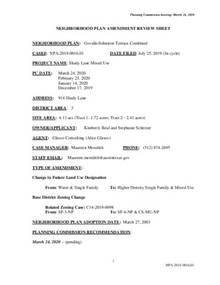
Planning Commission hearing: March 24, 2020 NEIGHBORHOOD PLAN AMENDMENT REVIEW SHEET DATE FILED: July 25, 2019 (In-cycle) NEIGHORHOOD PLAN: Govalle/Johnston Terrace Combined CASE#: NPA-2019-0016.01 PROJECT NAME: Shady Lane Mixed Use PC DATE: March 24, 2020 February 25, 2020 January 14, 2020 December 17, 2019 ADDRESS: 914 Shady Lane DISTRICT AREA: 3 SITE AREA: 4.13 acs (Tract 1- 1.72 acres; Tract 2 - 2.41 acres) OWNER/APPLICANT: Kimberly Beal and Stephanie Scherzer AGENT: Glasco Consulting (Alice Glasco) CASE MANAGER: Maureen Meredith STAFF EMAIL: Maureen.meredith@austintexas.gov TYPE OF AMENDMENT: Change in Future Land Use Designation From: Water & Single Family Base District Zoning Change PHONE: (512) 974-2695 To: Higher Density Single Family & Mixed Use Related Zoning Case: C14-2019-0098 From: SF-3-NP NEIGHBORHOOD PLAN ADOPTION DATE: March 27, 2003 PLANNING COMMISSION RECOMMENDATION: March 24, 2020 – (pending) To: SF-6-NP & CS-MU-NP 1 NPA-2019-0016.01 Planning Commission hearing: March 24, 2020 February 25, 2020- Postponed to March 24, 2020 on the consent agenda at the request of the Applicant. [R. Schneider – 1st; C. Kenny – 2nd] Vote: 12-0 [J. Shieh absent]. January 14, 2020 – Postponed on the consent agenda to February 25, 2020 at the request of the applicant. [J. Thompson – 1st; C. Kenny – 2nd] Vote: 9-0 [A. Azhar, C. Hempel, C. Llanes-Pulido and P. Seeger absent]. December 17, 2019 – Postponed to January 14, 2020 at the request of staff. [P. Howard – 1st; Y. Flores – 2nd] Vote: 10-0 [G. Anderson, C. Llanes-Pulido, T. Shaw absent]. STAFF RECOMMENDATION: Staff recommends Higher Density Single Family on Tract 1 and Neighborhood Mixed Use land use on Tract 2, in lieu of the applicant’s request for Mixed Use on Tract 2. BASIS FOR STAFF’S RECOMMENDATION: Staff recommends the applicant’s request for Higher Density Single Family on Tract 1 because there is single family land use to the north of Boggy Creek and to the west with Civic land use to the south. Higher Density Single Family is appropriate in this location. Staff recommends Neighborhood Mixed Use land use on Tract 2, in lieu of the applicant’s request for Mixed Use because this Tract is across the street from residential and office uses and would provide the opportunity for small-scale, neighborhood-friendly commercial, office and residential uses. The Govalle/Johnston Terrace Neighborhood Plan supports compatible and varied land uses, in addition to neighborhood-scale developments, which staff believes these land uses meet these goals. 2 Planning Commission hearing: March 24, 2020 3 Planning Commission hearing: March 24, 2020 LAND USE DESCRIPTIONS EXISTING LAND USE ON THE PROPERTY Single family - Detached or two family residential uses at typical urban and/or suburban densities. Purpose 1. Preserve the land use pattern and future viability of existing neighborhoods; 2. Encourage new infill development that continues existing neighborhood patterns of development; and 3. Protect residential neighborhoods from incompatible business or industry and the loss of existing housing. Application 1. Existing single‐ family areas should generally be designated as single family to preserve established neighborhoods; and 2. May include small lot options (Cottage, Urban Home, Small Lot Single Family) and two‐ family residential options (Duplex, Secondary Apartment, Single Family Attached, Two‐ Family Residential) in areas considered appropriate for this type of infill development. Water - Any public waters, including lakes, rivers, and creeks. Purpose 4 Planning Commission hearing: March 24, 2020 1. Identify and preserve existing water features. Application courses; and 1. Generally applies to any water feature, including lakes, creeks, rivers, and water 2. Not intended to be a prescriptive land use category, but an accurate reflection of future land use where water features are present. PROPOSED LAND USE ON THE PROPERTY Higher Density Single Family - Is housing, generally up to 15 units per acre, which includes townhouses and condominiums as well as traditional small‐ lot single family. Purpose 1. Provide options for the development of higher‐ density, owner‐ occupied housing in urban areas; and 2. Encourage a mixture of moderate intensity residential on residential corridors. Application 1. Appropriate to manage development on major corridors that are primarily residential in nature, and 2. Can be used to provide a buffer between high‐ density commercial and low‐ density residential areas. 3. Applied to existing or proposed mobile home parks. Mixed Use - An area that is appropriate for a mix of residential and non‐ residential uses. Purpose 1. Encourage more retail and commercial services within walking distance of residents; 2. Allow live‐ work/flex space on existing commercially zoned land in the neighborhood; 3. Allow a mixture of complementary land use types, which may include housing, retail, offices, commercial services, and civic uses (with the exception of government offices) to encourage linking of trips; 4. Create viable development opportunities for underused center city sites; 5. Encourage the transition from non‐ residential to residential uses; 5 Planning Commission hearing: March 24, 2020 6. Provide flexibility in land use standards to anticipate changes in the marketplace; 7. Create additional opportunities for the development of residential uses and affordable housing; and 8. Provide on‐ street activity in commercial areas after 5 p.m. and built‐ in customers for local businesses. Application 1. Allow mixed use development along major corridors and intersections; 2. Establish compatible mixed‐ use corridors along the neighborhood’s edge 3. The neighborhood plan may further specify either the desired intensity of commercial uses (i.e. LR, GR, CS) or specific types of mixed use (i.e. Neighborhood Mixed Use Building, Neighborhood Urban Center, Mixed Use Combining District); 4. Mixed Use is generally not compatible with industrial development, however it may be combined with these uses to encourage an area to transition to a more complementary mix of development types; 5. The Mixed Use (MU) Combining District should be applied to existing residential uses to avoid creating or maintaining a non‐ conforming use; and 6. Apply to areas where vertical mixed use development is encouraged such as Core Transit Corridors (CTC) and Future Core Transit Corridors. STAFF RECOMMENDED LAND USE Neighborhood Mixed Use - An area that is appropriate for a mix of neighborhood commercial (small‐ scale retail or offices, professional services, convenience retail, and shopfront retail that serve a market at a neighborhood scale) and small to medium‐ density residential uses. Purpose 1. Accommodate mixed use development in areas appropriate for a mix of residential uses and neighborhood commercial uses that serve surrounding neighborhoods; and 2. Provide transition from residential use to high intensity commercial or mixed use. Application 6 Planning Commission hearing: March 24, 2020 1. Appropriate for areas such as minor arterials and collectors, small parcels along major arterials that abut single‐ family residential development, and areas in environmentally sensitive zones where high intensity commercial uses are discouraged; and 2. May be used as a transition from high intensity commercial and residential uses to single‐ family residential uses. IMAGINE AUSTIN PLANNING PRINCIPLES 1. Create complete neighborhoods across Austin that provide a mix of housing types to suit a variety of household needs and incomes, offer a variety of transportation options, and have easy access to daily needs such as schools, retail, employment, community services, and parks and other recreation options. The property is near Capital Metro bus routes and is within walking distance to a number of businesses and services. The land uses could accommodate zoning that would provide a mix of housing types for a variety of incomes. 2. Support the development of compact and connected activity centers and corridors that are well-served by public transit and designed to promote walking and bicycling as a way of reducing household expenditures for housing and transportation. The property is located between Springdale Station Activity Center and Airport Blvd which is an Activity Corridor on the Imagine Austin Growth Concept Map. 3. Protect neighborhood character by ensuring context-sensitive development and directing more intensive development to activity centers and corridors, redevelopment, and infill sites. Because the property is not located on a activity corridor or within an activity center, staff is not recommending the Mixed Use land use along Shady Lane. 4. Expand the number and variety of housing choices throughout Austin to meet the financial and lifestyle needs of our diverse population. The Higher Density Single Family and staff’s recommendation of Neighborhood Mixed Use land use would provide the opportunity to expand the number and variety of housing choices. 5. Ensure harmonious transitions between adjacent land uses and development intensities. Staff’s recommendation of High Density Single Family and Neighborhood Mixed Use land is compatible for this location. 6. Protect Austin’s natural resources and environmental systems by limiting land use and transportation development over environmentally sensitive areas and preserve open space and protect the function of the resource. The property is not located in the Edwards Aquifer Recharge zone, but is within the City of Austin Fully Developed 25-year Floodplain. 7 Planning Commission hearing: March 24, 2020 7. Integrate and expand green infrastructure—preserves and parks, community gardens, trails, stream corridors, green streets, greenways, and the trails system—into the urban environment and transportation network. The property is located on the south side of Boggy Creek and has a significant amount of the land within the flood plain. See map below. 8. Protect, preserve and promote historically and culturally significant areas. To the best of staffs’ knowledge, there are no historic or cultural aspects to the property. 9. Encourage active and healthy lifestyles by promoting walking and biking, healthy food choices, access to affordable healthcare, and to recreational opportunities. 10. Expand the economic base, create job opportunities, and promote education to support a Not directly applicable. strong and adaptable workforce. Not directly applicable. creative art forms. Not applicable. 11. Sustain and grow Austin’s live music, festivals, theater, film, digital media, and new 12. Provide public facilities and services that reduce greenhouse gas emissions, decrease water and energy usage, increase waste diversion, ensure the health and safety of the public, and support compact, connected, and complete communities. Not applicable. 8 Fully Developed Floodplain and FEMA Floodplain Planning Commission hearing: March 24, 2020 9 Planning Commission hearing: March 24, 2020 Proximity to Imagine Austin Activity Centers and Corridors 10 Planning Commission hearing: March 24, 2020 Proximity to Parks Facilities 11 Planning Commission hearing: March 24, 2020 Proximity to Capital Metro Transportation Facilities IMAGINE AUSTIN GROWTH CONCEPT MAP Definitions Neighborhood Centers - The smallest and least intense of the three mixed-use centers are neighborhood centers. As with the regional and town centers, neighborhood centers are walkable, bikable, and supported by transit. The greatest density of people and activities in neighborhood centers will likely be concentrated on several blocks or around one or two intersections. However, depending on localized conditions, different neighborhood centers can be very different places. If a neighborhood center is designated on an existing commercial area, such as a shopping center or mall, it could represent redevelopment or the addition of housing. A new neighborhood center may be focused on a dense, mixed-use core surrounded by a mix of housing. In other instances, new or redevelopment may occur incrementally and concentrate people and activities along several blocks or around one or two intersections. Neighborhood centers will be more locally focused than either a regional or a town center. Businesses and services—grocery and department stores, doctors and dentists, shops, branch libraries, dry cleaners, hair salons, schools, restaurants, and other small and local businesses—will generally serve the center and surrounding neighborhoods. 12 Planning Commission hearing: March 24, 2020 Town Centers - Although less intense than regional centers, town centers are also where many people will live and work. Town centers will have large and small employers, although fewer than in regional centers. These employers will have regional customer and employee bases, and provide goods and services for the center as well as the surrounding areas. The buildings found in a town center will range in size from one-to three-story houses, duplexes, townhouses, and rowhouses, to low-to midrise apartments, mixed use buildings, and office buildings. These centers will also be important hubs in the transit system. Job Centers - Job centers accommodate those businesses not well-suited for residential or environmentally- sensitive areas. These centers take advantage of existing transportation infrastructure such as arterial roadways, freeways, or the Austin-Bergstrom International airport. Job centers will mostly contain office parks, manufacturing, warehouses, logistics, and other businesses with similar demands and operating characteristics. They should nevertheless become more pedestrian and bicycle friendly, in part by better accommodating services for the people who work in those centers. While many of these centers are currently best served by car, the growth Concept map offers transportation choices such as light rail and bus rapid transit to increase commuter options. Corridors - Activity corridors have a dual nature. They are the connections that link activity centers and other key destinations to one another and allow people to travel throughout the city and region by bicycle, transit, or automobile. Corridors are also characterized by a variety of activities and types of buildings located along the roadway — shopping, restaurants and cafés, parks, schools, single-family houses, apartments, public buildings, houses of worship, mixed-use buildings, and offices. Along many corridors, there will be both large and small redevelopment sites. These redevelopment opportunities may be continuous along stretches of the corridor. There may also be a series of small neighborhood centers, connected by the roadway. Other corridors may have fewer redevelopment opportunities, but already have a mixture of uses, and could provide critical transportation connections. As a corridor evolves, sites that do not redevelop may transition from one use to another, such as a service station becoming a restaurant or a large retail space being divided into several storefronts. To improve mobility along an activity corridor, new and redevelopment should reduce per capita car use and increase walking, bicycling, and transit use. Intensity of land use should correspond to the availability of quality transit, public space, and walkable destinations. Site design should use building arrangement and open space to reduce walking distance to transit and destinations, achieve safety and comfort, and draw people outdoors. BACKGROUND: The application was filed on July 25, 2019, which is in-cycle for neighborhood planning areas located on the east side of I.H.-35. The applicant proposes to change the future land use map from Water and Single Family to Higher Density Single Family and Mixed Use to build condos/duplexes and a commercial use on the property that has frontage on Shady Lane. 13 Planning Commission hearing: March 24, 2020 The applicant has an associated zoning case where they propose the change the zoning from SF-3-NP to SF-6-NP and CS-MU-NP. Please see zoning case report C14-2019-0098 for more information on the zoning case. PUBLIC MEETINGS: The ordinance-required community meeting was held on September 23, 2019. Approximately 252 meeting notices were mailed to people who live or have a utility account within 500 feet of the property, in addition to neighborhood organizations and environmental groups who requested notification for the area. Fifteen people attended the meeting, in addition to Alice Glasco, the applicant’s agent, the two property owners, and one city staff member. After staff gave a brief presentation about the applicant’s request and the planning process in general, the owners made a presentation and then questions were asked. Kim Beal, one of the property owners, said they bought the property 17 years ago. Shady Lane is now a commercial street with a lot of cars on it. They have had cats killed and now they have small children. We now have a vision for the property. We met with the Govalle/Johnston Terrace Neighborhood Plan Contact Team and they thought it could be commercial uses on the front part near Shady Lane and the back part proposed for residential. Kim said they are proposing three duplexes and they want to live in one of them. We want to live in the neighborhood. The two tracts are separated by a creek, so you cannot drive between them. Q. I see from your plan you are proposing four buildings. A. Yes, but it’s conceptual. Q. What is the proposed building height? A. Three to four stories. Q. What about the Atlas Flood Plain Maps? A. The new flood plain maps cover more area. The new building would be in the 500 year flood plain. The building would have to be raised up two feet. The building height could be 32 -40 feet, but subject to compatibility. All the property along Shady Lane with CS zoning has a maximum height of 60 feet. Q. You talked about Shady Lane having lots of cars and it being dangerous for pets and children, but how could your proposed rezoning make it safer? A. We will have off-street parking, so we won’t have cars parking on the street. Q. Are you developing the property yourself? A. We had a retirement community interested. The developer wanted to build four stories. We are interested in options that work for the neighborhood and for us. The front part proposed for commercial could be a joint venture, we could provide the land. We could have more control, but no one wants to talk to us because we don’t have commercial zoning. 14 Planning Commission hearing: March 24, 2020 Q. We realize things change and people can say they will build something. Does your zoning regulate the impervious cover? A. Yes, the zoning covers impervious cover and also the affected by the flood plain watershed. Q. If you plan to live in one of the units on the property and the back part of the property is better to build on, why not just expand to live on the back part? A. The house we have now is small, about 1200 sq. ft. It’s too small for four people. The property is just too big for us to maintain and to pay taxes one. We need a more manageable space. Q. What’s on the property now? A. There’s a house, two trailers, a shed and some farm tools. Q. What is the size of the three building in the back? A. Maybe 4,000 sq. ft, but we don’t know for sure. It would fall under the McMansion Ordinance. Q. People ask for SF-6 zoning a lot, but they don’t ask for SF-3 zoning. Why not ask for SF- 3 zoning? A. The property is currently zoned SF-3. The subdivision rules require subdivided land with each lot having access to a public street. The three lots don’t have enough street frontage. SF- 6 zoning allows a condo regime and we don’t need to subdivide. Q. Will your rezoning increase my taxes? A. Your taxes should be frozen because you’re older than 65. Q. Will you have a maximum of 30 dwelling units? A. We couldn’t really fit that many dwelling units. Q. The CS-MU zoning could be all office or commercial? A. Yes, but we are limited to the allowable height. Q. Will the school remain? A. As far as we know. Q. Why can’t you subdivide it into three lots? A. We can’t do flag lots. Q. You said a creek goes through this property, but this could be the last natural creek. I would hate for this to decrease the last part of a natural creek that has ducks. A. The Watershed Department is there to help protect this. If we get the zoning, we must meet all regulations during the site plan review. All environmental features must be protected. 15 Planning Commission hearing: March 24, 2020 Q. I called the City for speed bumps on Bolm Road because we will have lots of traffic. The City said it would slow down emergency vehicles. A. I will talk to the City and Public Works staff and look into it. Maybe we will have live/work units where people won’t have to drive. Q. Are you going to build it anyway? A. We don’t have the zoning to build, which is why we submitted the zoning case. Q. Someone could purchase the farm from you and you could live in the back of the property. A. We lost money on the urban farm, it’s not really something people want to do. Q. Could both tracts be SF-6? A. CS-MU could also have SF-6 housing built on it. Q. Maybe you could ask for MF zoning instead? A. We will look at this, but MU allows for multifamily uses. Q. Is the property listed for sale? A. We’ve had limited interest for a restaurant and farm, but it didn’t work out, but we have not listed it yet. Q. Is there other zoning you would be willing to look at that would allow only affordable housing or senior housing. It would put some constraints on it. CS-MU would allow a lot of stuff. A. We will look at MF zoning and possible conditional overlay to prohibit uses. Q. Maybe you could sell on property but keep the other for yourself to build a home one. A. There is commercial surrounding us. We either control what goes there or we sell it and someone else profits from it. We don’t know who much land we have to sell because of the creek issue. The road to the west does not belong to the City, it belongs to AISD. We don’t want to sell two single family lots. Q. Can you split the property into two SF-3 lots? A. We already have SF-3 zoning on the two lots. We don’t want to pay the money to expand. It’s not really livable. This is an opportunity zone. This is a way to bring public and private investors where people are looking to invest. We met with five groups of investors where we told them the neighborhood’s needs such as access to health care, food, etc. I can’t handle these three acres of land anymore. We are investing in the neighborhood and I would like to hear what you’d like to see here so we can be good stewards. Comments: We lived in our house for 37 years. Shady Lane is like a race track and we tried to get speed bumps. This is caused by development in the neighborhood. 16 Planning Commission hearing: March 24, 2020 I live on the property in one of the trailers. I know Kim and Stephanie’s dedication to the land and they’ve turned it into a beautiful urban space. They love this land and the neighborhood. The neighborhood has changed. Adding more houses to the property would be a good thing. They are not in it for a quick buck. They are committed to what happens. Zoning to commercial would allow flexibility to what’s possible. It’s hard to say what we want on the property because we really want less traffic, less cars. There’s so much development going around the area with more apartments. My concern is about noise. I don’t want noise from a restaurant. We want affordable housing, not housing that crams as many people onto the There are small businesses being replaced. This would be a good location for small property. businesses. CITY COUNCIL DATE: January 23, 2020 March 26, 2020 ACTION: ACTION: Postponed to March 26, 2020 at the request of staff on the consent agenda. [A. Kitchen – 1st; A. Alter – 2nd] Vote 9-0 [J. Flannigan off the dais. Mayor Adler absent]. ACTION: (pending) 17 Applicant Summary Letter from Application Planning Commission hearing: March 24, 2020 18 Planning Commission hearing: March 24, 2020 19 Letter of Recommendation from the Govalle/Johnson Terrace Neighborhood Plan Contact Team (NPCT) Planning Commission hearing: March 24, 2020 (No letter received at this time) 20 Planning Commission hearing: March 24, 2020 Site 21 Planning Commission hearing: March 24, 2020 22 Planning Commission hearing: March 24, 2020 23 Planning Commission hearing: March 24, 2020 24 Planning Commission hearing: March 24, 2020 25 Planning Commission hearing: March 24, 2020 26 Planning Commission hearing: March 24, 2020 27 Planning Commission hearing: March 24, 2020 28 Planning Commission hearing: March 24, 2020 29 Planning Commission hearing: March 24, 2020 30 Planning Commission hearing: March 24, 2020 31 Planning Commission hearing: March 24, 2020 32 Planning Commission hearing: March 24, 2020 33 Planning Commission hearing: March 24, 2020 34 Planning Commission hearing: March 24, 2020 35 Planning Commission hearing: March 24, 2020 36 Planning Commission hearing: March 24, 2020 37 Planning Commission hearing: March 24, 2020 38