Item B-12 (C14-2019-153 - Old Koenig V Rezoning; District 7).pdf — original pdf
Backup
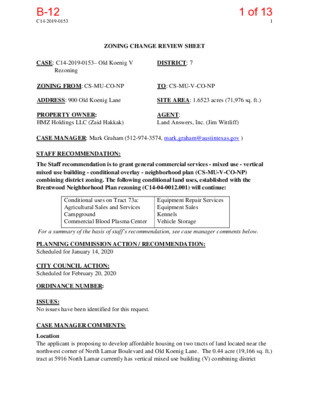
C14-2019-0153 1 ZONING CHANGE REVIEW SHEET CASE: C14-2019-0153– Old Koenig V DISTRICT: 7 Rezoning ZONING FROM: CS-MU-CO-NP TO: CS-MU-V-CO-NP ADDRESS: 900 Old Koenig Lane SITE AREA: 1.6523 acres (71,976 sq. ft.) PROPERTY OWNER: HMZ Holdings LLC (Zaid Hakkak) AGENT: Land Answers, Inc. (Jim Wittliff) CASE MANAGER: Mark Graham (512-974-3574, mark.graham@austintexas.gov ) STAFF RECOMMENDATION: The Staff recommendation is to grant general commercial services - mixed use - vertical mixed use building - conditional overlay - neighborhood plan (CS-MU-V-CO-NP) combining district zoning. The following conditional land uses, established with the Brentwood Neighborhood Plan rezoning (C14-04-0012.001) will continue: Conditional uses on Tract 73a: Agricultural Sales and Services Campground Commercial Blood Plasma Center Equipment Repair Services Equipment Sales Kennels Vehicle Storage For a summary of the basis of staff’s recommendation, see case manager comments below. PLANNING COMMISSION ACTION / RECOMMENDATION: Scheduled for January 14, 2020 CITY COUNCIL ACTION: Scheduled for February 20, 2020 ORDINANCE NUMBER: ISSUES: No issues have been identified for this request. CASE MANAGER COMMENTS: Location The applicant is proposing to develop affordable housing on two tracts of land located near the northwest corner of North Lamar Boulevard and Old Koenig Lane. The 0.44 acre (19,166 sq. ft.) tract at 5916 North Lamar currently has vertical mixed use building (V) combining district 1 of 13B-12 C14-2019-0153 2 zoning as a result of the City-initiated rezoning process for properties fronting on core transit corridors, completed in August 2009. The subject site is the adjoining 1.65 acre (71,874 sq. ft.) tract on the west at 900 Old Koenig which does not have the vertical mixed use building (V) combining zoning district. The two tracts are under unified ownership and control for the proposed development. Request Applicant requests rezoning from general commercial services – mixed use - conditional overlay – neighborhood plan (CS-MU-CO-NP) district to general commercial services–mixed use- vertical mixed use building-conditional overlay–neighborhood plan (CS-MU-V-CO-NP) district. Existing Conditions The Old Koenig Lane tract is currently developed with two single-story buildings used for warehousing and offices. Developer will raze those buildings along with the single story commercial building at 5916 North Lamar Blvd. Proposed Conditions The applicant proposes to rezone the property and add a vertical mixed use building (-V) combining district to the existing zoning and develop it with 8,500 square feet of ground floor retail and services and build up to 240 apartments. The addition of - V provides an additional development option to a property, but allows it to retain the ability to redevelop under the existing CS base district. A – V does not grant: 1) additional height to the base zoning district which is 60 feet in the CS district or 2) additional impervious cover which is limited to 95 percent in the Shoal Creek/Waller Creek watersheds. The addition of - V also does not waive applicable compatibility standards. Conditional Uses There are existing conditional uses on 900 Old Koenig Lane from the 2004 City initiated Brentwood Neighborhood Plan rezoning (Case C14-04-0012.001-Ordinance No. 040513-33A) That case changed the zoning from CS-1 to CS-MU-CO-NP, (see related cases with a list of conditional uses.) Different Standards Applicant accepts the list of conditional uses, and the vertical mixed use building standards. A building constructed under vertical mixed use building ( - V) standards is required to contain a mix of residential and commercial uses, and the result is typically retail, restaurants and offices on the ground floor, and residential units on the upper levels. On the subject site, there is also the opportunity to waive: 1) the front and interior side setbacks (except where compatibility applies), 2) the 2:1 floor-to-area ratio established by CS zoning, and 3) the minimum site area requirement which determines the number of dwelling units on a site by requiring a certain amount of square footage of land for a specific type of multi-family unit (efficiency, one bedroom, two bedroom). A – V building is also eligible for 60 percent of the minimum requirement for off-street parking. Finally, a – V building has an established affordability level for rental units which is 10 percent 2 of 13B-12 C14-2019-0153 3 of the residential units set aside for households earning no more than 80 percent of the current Median Family Income (MFI) currently for a family of 4 ($65,100), for a period of 40 years. The proposed buildings will comply with Compatibility and Neighborhood Standards such that the building height will be 30 feet (2 stories) near the church (western site boundary) and transition to 55 feet in height at Lamar. BASIS OF RECOMMENDATION: Staff recommends general commercial services – mixed use - vertical mixed use building – conditional overlay – neighborhood plan (CS-MU-V-CO-NP) district zoning for 900 Old Koenig Lane. The Conditional Overlay would carry over the list of conditional uses established by the Brentwood Neighborhood Plan rezoning. 1. The proposed zoning should be consistent with the purpose statement of the district sought. Vertical Mixed Use Building (V) combining district may be applied in combination with any commercial base zoning district and allows for a combination of office, retail, commercial and residential uses within a vertical mixed use building. The applicant proposes to keep 8,500 sq. ft. of ground floor commercial uses and build a different (residential) use above. The requested V zone district is specifically meant for areas that are well served by transportation corridors such as Lamar, in this case. 2. Zoning should not constitute a grant of special privilege to an individual owner; Granting of the request should result in an equal treatment of similarly situated properties. The Brentwood/Highland Combined Neighborhood Plan… 3. The proposed zoning should satisfy a real public need and not provide special privilege. The applicant proposes to build housing and affordable housing along a core transit corridor. Housing generally and affordable housing specifically are in demand in Austin and the proposed location is consistent with community goals for compact and walkable spaces. 4. The proposed zoning should be consistent with the goals and objectives of the City Council. The proposed zoning and associated project are consistent with the direction from Imagine Austin because it provides a mix of commercial and residential uses in an Activity Corridor and near a Town Center. 3 of 13B-12 C14-2019-0153 4 EXISTING ZONING AND LAND USES: Site North Zoning CS-MU-CO-NP CS-MU-V-CO-NP, MF-3-NP Auto repair, office, multi-family Office, warehouse Land Uses residential Utilities: (North Austin Reservoir and electric substation) Restaurant, Texas Dept. of Public Safety P-NP South East West CS-MU-V-CO-NP, UNZ GR-MU-CO-NP Church NEIGHBORHOOD PLANNING AREA: Brentwood TIA: TIA determination is deferred to site plan submittal when final land use and intensities will be known. WATERSHEDS: Shoal Creek, Waller Creek –Urban OVERLAYS: ADU Approximate Area Reduced Parking, Residential Design Standards: LDC/25-2 Subchapter F SCHOOLS: Brentwood Elementary Lamar Middle McCallum H.S. NEIGHBORHOOD ORGANIZATIONS Austin Independent School District Austin Lost and Found Pets Austin Neighborhoods Council Bike Austin Brentwood Neighborhood Assn. Brentwood Neighborhood Plan Contact Team Friends of Austin Neighborhoods AREA CASE HISTORIES: Homeless Neighborhood Association Neighborhood Empowerment Foundation North Austin Neighborhood Alliance SELTexas Shoal Creek Conservancy Sierra Club, Austin Regional Group Number Request Commission City Council C14-04-0012 Brentwood/ Highland Neighborhood To Grant Plan Rezonings (05/13/2004) Apvd. 4 of 13B-12 C14-2019-0153 Number C14-2009- 0055 C14-2009- 0012 6701 Guadalupe St 5 Request Commission City Council Brentwood Neighborhood Planning Area Vertical Mixed Use Building (V) Zoning Opt-In/Opt Out Process To Grant Highland Neighborhood Planning Area Vertical Mixed Use Building (V) Zoning Opt-in/Opt-Out Process. To Grant (08/27/2009) Apvd. (06/11/2009) Apvd. C14-2008- 0030 Lamar/Justin Lane TOD Station Area Plan To Grant 12/11/2008 Apvd. RELATED CASES: C14-04-0012.001 changed zoning from CS-1 to CS-MU-CO-NP on May 13, 2004. Conditional uses on Tract 73a: Agricultural Sales and Services Campground Commercial Blood Plasma Center Equipment Repair Services Equipment Sales Kennels Vehicle Storage OTHER STAFF COMMENTS: Comprehensive Planning The subject tract for this rezoning case is located 825 feet south of the Crestview Station, which is a Town Center and approximately 185 feet west of the North Lamar Boulevard, which is an Activity Corridor. This rezoning case is located on the north side of Old Koenig Lane, on a 1.652 acre tract of land located in the Brentwood Neighborhood Planning Area, which is part of the Brentwood/Highland Combined Neighborhood Planning Area. The property contains two one-story buildings that are used as offices and commercial businesses. Surrounding land uses includes an auto junk yard, an office building, an apartment complex and a funeral home to the north; to the south is the North Austin Reservoir and Pump Station and an Austin Energy utility transmission station; to the west is a private pre-school and two churches; and to the east is a fast food restaurant and the Texas Department of Public Safety office building. The proposed use is a 240 unit apartment complex (includes affordable housing units) and 8,500 square feet of commercial space, which will provide room for between four to seven businesses. Connectivity. Public sidewalks are located only on one side of Old Koenig Lane but on both sides of this section of North Lamar Boulevard. There is a CapMetro transit stop located less than 200 feet away, on North Lamar Boulevard. Connectivity and mobility options are average. Brentwood/Highland Combined Neighborhood Plan (BHCNPA) 5 of 13B-12 C14-2019-0153 6 The BHCNP Future Land Use Map (FLUM) classifies this portion of the planning areas as ‘Mixed Use.’ Mixed Use is defined as an area that is intended for a mix of residential and non- residential uses, including office, retail and commercial services. The following text and policies are excerpted from the BHCNP and are applicable to this case: Goal 3. Encourage a mixture of compatible and appropriately scaled business and residential land uses in the neighborhood and mixed-use development on major corridors to enhance this diversity. (p. 28) Goal 4. Preserve locally owned small businesses in the neighborhood and encourage new ones that are walkable and serve the needs of the neighborhood. Goal 5. Focus higher density uses and mixed-use development on major corridors, and enhance the corridors by adding incentives for creative, aesthetically pleasing, pedestrian- friendly redevelopment. Koenig Lane (pg. 32) Koenig Lane is one of the most important land use issues in the Brentwood Neighborhood. Koenig Lane has two distinct segments in Brentwood. Woodrow Ave divides the two segments, with one running east of Woodrow to Lamar, and the other west of Woodrow to Burnet. The character of the two segments is significantly different. The segment that is east of Woodrow has larger lot sizes. (Staff note: this property is east of Woodrow Avenue). Historically this segment was used as office or commercial uses. As Koenig Lane started to carry more traffic in the 1980’s and 1990’s some of the properties in the segment that is west of Woodrow began to convert to office and commercial uses. These conversions were done in a piecemeal fashion creating a mixed land use pattern including single-family and office uses, as well as some commercial uses. This created a mixed land use pattern and in some cases created situations where adjacent uses were incompatible. The neighborhood stakeholders were very eager to have an opportunity to plan all of Koenig Lane in a comprehensive way. The Western Segment of Koenig Lane (pg. 34) The vision for the western segment of Koenig Lane is to create a land use pattern that provides a range of viable uses, ensures that uses are compatible with the nearby single-family residential areas, and accommodates some neighborhood serving commercial uses where appropriate. Today, Koenig Lane caries 25,000 – 30,000 vehicles trips a day, and almost all of the stakeholders agree that this type of traffic is incompatible with low-density single-family land uses. However, the plan does encourage some higher-density residential on this segment of the street. 6 of 13B-12 C14-2019-0153 7 The desired land use on mid-block properties is for small-scale office uses and some residential preferably above the office use. The Future Land Use Map designates the intersections as Commercial Mixed-Use. West 6th Street, between Lamar and Mopac, with its mix of small retail, office and apartments is a model for the type of pedestrian uses that are desired for the commercial properties in this part of Koenig Lane includes small and locally-owned businesses such as restaurants, bakeries, art galleries, and antique stores. Land Use Objective B3: Ensure that there is a mix of residential and commercial zoning to accommodate both housing and the services resident’s needs in the neighborhood, and that commercial zoning in each area is appropriate for its location. (p.60) The vision for the western segment of Koenig Lane is to create a land use pattern that provides a range of viable uses, ensures that uses are compatible with the nearby single-family residential areas, and accommodates some neighborhood serving commercial uses where appropriate. Recommendations: 1. Maintain commercial zoning on the corridors and in transitional areas between the corridors and residential areas. 2. Allow mixed use on commercial corridors. Land Use Objective B4: Encourage the development of neighborhood serving business and offices by maintaining and adding neighborhood commercial and limited office on smaller corridors and in transitional areas between corridors and residential areas where appropriate. (p.61) Recommendations: 1. Add the mixed-use (MU) combining district on Koenig and interior properties with commercial or office zoning. 2. Allow neighborhood serving commercial uses at intersections on Koenig west 3. Allow neighborhood and community serving office uses on interior properties of Woodrow. on Koenig west of Woodrow. Land Use Objective B-5: Focus higher density uses on major corridors and add special use options to enhance the corridors. (p. 61) Recommendation: 1. Add the mixed-use (MU) combining district on Burnet, Lamar, and Koenig Lane east of Woodrow. 7 of 13B-12 C14-2019-0153 8 Urban Design Guidelines Objective 3: Redevelopment of multi-family residential projects should be compatible with adjacent single-family areas. (p. 122) • Guideline 3.1: Multi-family buildings less than 100 feet in width on any street facing side are more in keeping with the scale of the neighborhood. Building facades that express the interior organization of suites or structural bays relate better to the scale of single-family homes. • Guideline 3.2: Landscaped front yards with porches or balconies and a walkway connecting the building to the street sidewalk are neighborhood characteristics. Front doors and windows facing the street encourage neighborliness and enhance security by putting “eyes on the street”. Ground floor suites should have exterior doors facing the street. • Guideline 3.4: Parking lots along the street detract from the pedestrian-oriented character of the neighborhood. Locate parking lots to the side or behind the building, or buffer the lot from street view by a fence or hedge, low enough to screen the cars but allowing visibility for security, helps to preserve the quality of the streetscape. While over a dozen local businesses will be lost with the demolition of the two office/commercial building, this small area plan does support ‘small-scale office uses and some residential preferably above the office use’, which is proposed in the proposed project. Imagine Austin The subject property is located within 200 feet of the North Lamar Activity Corridor and south of the Crestview Station Town Center. Like many Imagine Austin Centers, this center is represented by a circle of globular shape that reflects the general location where the center should be located in the future. The center’s actual boundaries would need to be clarified through a small area planning process. The project is adjacent to North Lamar Boulevard, which is an Imagine Austin Activity Corridor. Activity Corridors are intended to allow people to reside, work, shop, access services, people watch, recreate, and hang out without traveling far distances. They are characterized by a variety of activities and types of buildings located along the roadway – shopping, restaurants and cafes, parks, schools, single-family houses, apartments, public buildings, houses of worship, mixed-use buildings, and offices. The following Imagine Austin policies are applicable to this case: • LUT P4. Protect neighborhood character by directing growth to areas of change that includes designated redevelopment areas, corridors and infill sites. Recognize that different neighborhoods have different characteristics and new and infill development should be sensitive to the predominant character of these communities. • LUT P5. Create healthy and family-friendly communities through development that includes a mix of land uses and housing types and affords realistic opportunities for transit, bicycle, and pedestrian travel and provides both community gathering spaces, parks and safe outdoor play areas for children. 8 of 13B-12 C14-2019-0153 9 • HN P11. Protect neighborhood character by directing growth to areas of change and ensuring context sensitive infill in such locations as designated redevelopment areas, corridors, and infill sites. Based upon the policies taken from both the small area plan for this area, and Imagine Austin, this project appears to be supported because it will offers a mixture of uses, including residential and commercial along this busy corridor, which is adjacent to an Activity Corridor and Town Center. It is also hoped that the developer designs this project to conform to the BHCNPA Voluntary Design Guidelines to make this a neighborhood and pedestrian friendly project. Transportation The Austin Strategic Mobility Plan (ASMP) adopted 04/11/2019, calls for 70 feet of right-of-way for Old Koenig Lane. Right-of-way dedication will be required at the time of subdivision and/or site plan. A traffic impact analysis was not required for this case because the traffic generated by the proposed zoning does not exceed the threshold of 2,000 vehicle trips per day. TIA requirement will be re-assessed at the time of site plan. The adjacent street characteristics table is provided below: Name ROW Pavement Classification Sidewalks Bicycle Route No Level 2 Yes 35’ 45’ Capital Metro (within ¼ mile) Yes Old Koenig Ln. Environmental 1. The site is not located over the Edwards Aquifer Recharge Zone. The site is located in the Shoal Creek Watershed of the Colorado River Basin, which is classified as an Urban Watershed by Chapter 25-8 of the City's Land Development Code. It is in the Desired Development Zone. 2. Zoning district impervious cover limits apply in the Urban Watershed classification. 3. According to floodplain maps there is no floodplain within or adjacent to the project location. 4. Standard landscaping and tree protection will be required in accordance with LDC 25-2 and 25-8 for all development and/or redevelopment. 5. At this time, site specific information is unavailable regarding vegetation, areas of steep slope, or other environmental features such as bluffs, springs, canyon rimrock, caves, sinkholes, and wetlands. 6. This site is required to provide on-site water quality controls (or payment in lieu of) for all development and/or redevelopment when 8,000 s.f. cumulative is exceeded, and on site control for the two-year storm. 9 of 13B-12 C14-2019-0153 10 Site Plan SP1. Site plans will be required for any new development other than single-family or duplex residential. SP2. Any development which occurs in an SF-6 or less restrictive zoning district which is located 540 feet or less from property in an SF-5 or more restrictive zoning district will be subject to compatibility development regulations. SP3. Any new development is subject to Subchapter E. Design Standards and Mixed Use. Additional comments will be made when the site plan is submitted. SP4. FYI: Additional design regulations will be enforced at the time a site plan is submitted. SP5. FYI: VMU standards can be found in 25-2 Subchapter E § 4.3.3. COMPATIBILITY STANDARDS SP6. The site is subject to compatibility standards due to proximity of SF-3-NP zoning to the northwest and southwest. The following standards apply: • No structure in excess of two stories or 30 feet in height may be constructed within 50 feet of the property line. 100 feet of the property line. • No structure in excess of three stories or 40 feet in height may be constructed within • For a structure more than 100 feet but not more than 300 feet from property zoned SF-5 or more restrictive, height limitation is 40 feet plus one foot for each 10 feet of distance in excess of 100 feet from the property zoned SF-5 or more restrictive. • For a structure more than 300 feet but not more than 540 feet from property zoned SF-5 or more restrictive, 60 feet plus one foot for each four feet of distance in excess of 300 feet from the property zoned SF-5 or more restrictive. • An intensive recreational use, including a swimming pool, tennis court, ball court, or playground, may not be constructed 50 feet or less from property in an SF-5 or more restrictive zoning district. DEMOLITION AND HISTORIC RESOURCES SP7. The applicant is responsible for requesting relocation and demolition permits once the site plan is approved. The City Historic Preservation Officer will review all proposed building demolitions and relocations prior to site plan approval. If a building meets city historic criteria, the Historic Landmark Commission may initiate a historic zoning case on the property. RESIDENTIAL DESIGN STANDARDS OVERLAY SP8. The site is subject to 25-2 Subchapter F. Residential Design and Compatibility Standards. 10 of 13B-12 C14-2019-0153 11 Austin Water Utility FYI: The landowner intends to serve the site with City of Austin water and wastewater utilities. The landowner, at own expense, will be responsible for providing any water and wastewater utility improvements, offsite main extensions, water or wastewater easements, utility relocations and or abandonments required by the proposed land use. Depending on the development plans submitted, water and or wastewater service extension requests may be required. Water and wastewater utility plans must be reviewed and approved by Austin Water for compliance with City criteria and suitability for operation and maintenance. All water and wastewater construction must be inspected by the City of Austin. The landowner must pay the City inspection fee with the utility construction. The landowner must pay the tap and impact fees once the landowner makes an application for Austin Water utility tap permits. INDEX OF EXHIBITS TO FOLLOW Exhibit A: Zoning Map Exhibit B: Aerial Map 11 of 13B-12 SF-3-NP ( E V W A O R D O O W ( SF-3-NP ( ( ( ( ( ( ( ( ( ( ( ( ( ( ( ( ( ( ( ( ( ( ( ( ( ( ( ( ( ( SF-3-NP ALGUNO RD SF-3-NP PALO DURO RD SF-3-NP ( ( ( ( ( ( ( ( ( ( ( ( ( ( ( ( LAUNDRY GAS\STATION ( ( ( ( USED\CARS CONV.\STORE GR-MU-CO-NP W KOENIG LN 59-148 CAR WASH MF-6-CO-NP C14-2016-0071 Tract 1 SP85-55 ( ( MF-3-NP SP90-49C GAS ( ( ( ( ( SF-3-NP ( ( ALEGRIA RD ( ( ( ( ( ( ( ( ( ( ( ( ( ( ( ( ( ( ( ( ( ( ( ( ( ( ( SF-3-NP ( ( ( ( ( ( ( ( ( ( = ( ( SF-3-NP ( ( ( ( ( ( ( ( ( ( SF-3-NP ( ( ( ( ( ( ( ( ( ( ( ( ( C14-04-0012 ( ( ( ( ( ( ( ( ( ( ( SF-3-NP ( ( ( ( ( ( ( ( = = ROMERIA DR ( ( ( ( = = = = = ( ( SF-3-NP ( ( 77-62 69-39 ( ( ( ( ( ( ( ( ( ( ( ( ( ( ( ( ( ( ( ( ( ( POOL\SALES REAL\ESTATE 65-142 LR-MU-CO-NP GR-MU-CO-NP VAC. BLDG. ( ( AURORA DR ( ( ( ( ( ( ( ( ( ( ( = ( = ( ( AURORA CIR ( ( ( ( ( ( ( ( ( ( ( APTS. APTS. MF-3-NP 65-204 GR-MU-CO-NP CHURCH ( SF-3-NP ( PAYNE AVE ( WILD ST ( ( ( ( ( ( ARCADIA AVE ( ( ( ( ( ( ( ( CS-MU-CO-NP ( ( BODY SHOP CP14-74-16 AUTO REPAIR TOD-NP CABINET SHOP OFC. CYCLE SALES 70-234 WHSE N LAMAR BLVD SP85-43 83-37 ( ( WILD ST ( ( INSULATION\COMPANY TOD-NP CAFE OFC. OFFICE RZ87-006 SEPTIC TOD-NP TANK CO. GLASS GARAGE AIR COND. SERVICE NPA-2008-0018.01 SP95-0210CS NURSING HOME APTS. C14-2008-0030 LAUNDRY DRIVE-IN LAMAR PL MF-3-NP APTS. CS-MU-CO-NP PARKING FUNERAL HOME CS-1-MU-V-CO-NP AUTO\SUPPLIES FAST AUTO\REPAIR APTS. ( ( 04-0012.003 71-61 BURNS ST ( ( ( ( ( ( ( ( ( APTS. 83-305 SF-3-NP 68-96 SF-3-NP HAMMACK DR SF-3-NP 83-172 83-172RC LO-NP ( ( ( ( ( ( ( ( ( ( ( ( ( GAS AUTO SUPPLY BLIND CO. PET SHOP TOD-NP DENSON DR SP92-0144C D.P.S. LICENSING CENTER GR-MU-CO-NP CHURCH ! ! 65-194 ! ! ! ! ! ! ! CS-MU-CO-NP C14-2009-0055 CS-MU-V-CO-NP OFFICE AUTO REPAIR ! SP95-210CS APTS. ! ! ! OLD KOENIG LN ! ! ! ! OFFICE PARK ! VET\CLINIC R787-038 C14-04-0012(PART) ! ! ! NPA-2009-0018.01 C14-2009-0012 CS-NP MCALLUM HIGH SCHOOL BOWLING ALLEY/PARKING CS-MU-CO-NP GROVER AVE MF-3-NP C14-04-0012 HIGH SCHOOL SF-3-NP UNZ TEXAS DEPARTMENT OF PUBLIC SAFTEY ( ( ( ( ( SF-3-NP APTS. MF-3-NP SUNSHINE DR 86-271 CITY OF AUSTIN WATER WORKS P-NP CITY OF AUSTIN STREET LIGHT DIVISION SF-3-NP ( ( ( P-NP CITY OF AUSTIN WATER RESERVOIR 86-271 P81-010 SF-6-NP 97-0128 05-0090 LR-MU-CO-NP C14-05-0090 SRVC\STATION ( ( ( ( ( ( ( ( C14-2009-0055 CS-MU-V-CO-NP STARK ST 95-049 SF-3-NP LO-MU-CO-NP LO-MU-NP CS-MU-CO-NP AUTO\SRVC APARTMENTS MF-4-NP C14-2009-0055 CHURCH YOUTH CENTER CS-MU-V-CO-NP 68-32 SP85-085 CS-MU-CO-NP AUTO\REPAIR APTS. REST. CS-1-MU-V-CO-NP C14-2009-0055 SP91-0013C 78-107 SP89-031C CS-V-CO-NP SP92-059C P77-16 FAST\FOOD BRAKE\SVC 77-32 P77-16 CS-MU-V-CO-NP CS-V-CO-NP C14-2016-0075 SP-03-0317C RESTAURANT 74-001 C14-02-0009 C14-2008-0002 BANK SHOPPING CENTER DRIVE-IN GROCERY LAUNDRY GR-MU-NP 75-123 LO-MU-NP SF-6-NP ( ( PARKING CS-MU-CO-NP APTS. 77-32 SP89- ( SF-3-NP SUBJECT TRACT PENDING CASE ZONING BOUNDARY ! ! ! ! ! ! ( SF-3-NP ( ( ( PARKING HOUSTON ST SF-3-NP ( ( ( ( ( ( ( ± 1 " = 400 ' D.P.S. MOTOR POOL UNZ FOOD CS-CO-NP ZONING CS-1-CO-NP ZONING CASE#: C14-2019-0153 DEPARTMENT OF PUBLIC SAFTEY ( ( ( ( EXHIBIT A This product is for informational purposes and may not have been prepared for or be suitable for legal, engineering, or surveying purposes. It does not represent an on-the-ground survey and represents only the approximate relative location of property boundaries. This product has been produced by CTM for the sole purpose of geographic reference. No warranty is made by the City of Austin regarding specific accuracy or completeness. Created: 11/18/2019 SP87-004 AUSTIN INDEPENDENT SCHOOL DISTRICT ADMINISTRATIVE OFFICE 87-013 GUADALUPE ST P-NP UNZ W SKYVIEW RD ( ( ( ( ( SF-3-NP ( ( ( CHESTERFIELD AVE ( ( SF-3-NP ( ( ( ( AVENUE C SF-3-NP ( ( ( 12 of 13B-12 16 5 23 11 20 E V A 14 22 13 27 12 24 23 10 2 17 18 9 8 7 J28 6 1 19 W SF-3-NP 21 5 13 O 12 R 22 23 24 D 10 25 11 O 15 9 14 O 26 8 7 W 16 1 17 6 SF-3-NP SF-3-NP 18 4 19 20 21 12 3 11 22 10 13 9 24 8 7 ALGUNO RD 15 14 6 25 SF-3-NP 16 5 4 PALO DURO RD 17 18 19 20 2 1 7 21 6 5 22 4 SF-3-NP 12-W 13-W 2 W KOENIG LN A 1 9 8 10 11-W 7A 1 9 MF-6-CO-NP CS-MU-CO-NP GROVER AVE MF-3-NP 1 SF-3-NP SF-3-NP J27 25 26 5 3 4 2 SF-3-NP 29 28 30 2 29 1 2 4 3 27 28 1 25 1 3 4 5 1 10 2 GROVER AVE 3 4 4 5 1 7 2 9 8 26 8 4 3 9 3 2 6 SF-3-NP 5 23 6 5 AURORA DR 78 3 10 2 12 11 1 6 9 2 LR-MU-CO-NP 10 SUNSHINE DR GR-MU-CO-NP 9 1-A GR-MU-CO-NP OLD KOENIG LN 5 P-NP SF-6-NP LR-MU-CO-NP 9 7 1 5 2 LO-MU-NP 3 CS-MU-CO-NP P-NP 25 23 18 21 15 17 SF-3-NP 13 STARK ST 11 20 22 18 SF-3-NP MF-3-NP 10 A A MF-4-NP 1A CS-1-MU-V-CO-NP N LAMAR BLVD A CS-V-CO-NP A 3 CS-MU-CO-NP 2A 2 1 4 1 4 GR-MU-NP B LO-MU-NP SUNSHINE DR 1 SF-6-NP HOUSTON ST 2 16 14 15 1 SF-3-NP 13 4 2 3 17 16 15 13 12 ± 1'' = 400' SUBJECT TRACT ZONING BOUNDARY PENDING CASE CREEK BUFFER ! ! ! ! ! ! 30 6 1 5 1 8 3 2 1 24 23 2 3 7 22 1 2 20 2 3 23 4 PAYNE AVE 24 5 ARCADIA AVE SF-3-NP 6 1 7 TRACT ONE 2 3 2 8 3 9 10 K28 4 12 4 5 5 6 7 11 13 14 22 SF-3-NP 8 CS-MU-CO-NP 10 9 6 19 18 20 11 15 2-A 17 16 15 16 4 ALEGRIA RD 1-A WILD ST 13 17 14 6 TOD-NP 7 18 8 9 19 11 10 10 9 1 20 13 11 A 12 B D 2 C ROMERIA DR 7 1 MF-3-NP 6 5 4 7 3 CS-MU-CO-NP 1 2 2 1 3 AURORACIR 4 CS-1-MU-V-CO-NP 2 5 11 CS-MU-V-CO-NP 10 6 8 7 4 MF-3-NP 1 N LAMAR BLVD 1 1 TOD-NP A LAMAR PL B 2A TOD-NP 1 1 2 1 DENSON DR 2 BURNS ST K27 1 2 22 21 1A A 1 1 6 3 3 6 1 5 TOD-NP 10 9 11 1 A 2 3 7 17 6 1 5 2 16 HAMMACKDR 15 1 13 3 2 4 5 6 SF-3-NP 7 19 8 20 18 LO-NP 13-A F B C14-2019-0153 6 2 3 4 N LAMAR BLVD CS-NP UNZ P-NP UNZ GUADALUPE ST 18 17 16 15 14 13 12 11 10 AVE 9 8 30 7 29 6 SF-3-NP SF-3-NP 21 Copyright nearmap 2015 22 20 27 CHESTERFIELD UNZ W K O E NIG L N CS-V-CO-NP 1 CS-CO-NP OLD KOENIG V REZONING ZONING CASE#: C14-2019-0153 LOCATION: SUBJECT AREA: 1.65 ACRES GRID: K27MARK GRAHAM MANAGER: CS-1-CO-NP EXHIBIT B This map has been produced by the Communications Technology Management Dept. on behalf of the Planning Development Review Dept. for the sole purpose of geographic reference. No warranty is made by the City of Austin regarding specific accuracy or completeness. 13 of 13B-12