REGULAR MEETING of the PLANNING COMMISSION TUESDAY, OCTOBER 22, 2024, 6:00 PM AUSTIN CITY HALL, COUNCIL CHAMBERS, ROOM 1001 301 WEST 2ND STREET AUSTIN, TEXAS Some members of the Planning Commission may be participating by videoconference. The meeting may be viewed online at: http://www.austintexas.gov/page/watch-atxn-live. Public comment will be allowed in-person or remotely via telephone. Speakers may only register to speak on an item once either in-person or remotely. Registration no later than 2 PM the day of the meeting is required for remote participation by telephone. For more information on public comment, please see the agenda section “Speaker Registration”. Please contact Ella Garcia, Staff Liaison, for questions regarding speaker registration at LandUseLiaison@austintexas.gov or by phone at 512-978-0821. CURRENT BOARD MEMBERS/COMMISSIONERS: Claire Hempe1, Chair (District 8) Awais Azhar, Vice Chair (Mayor’s Representative) Greg Anderson, Secretary (District 4) Alice Woods, Parliamentarian (District 2) Patrick Howard (District 1) Nadia Barrera-Ramirez (District 3) Felicity Maxwell (District 5) EX-OFFICIO MEMBERS: Casey Haney (District 6) Ryan Johnson (District 7) Danielle Skidmore (District 9) Grayson Cox (District 10) Alberta Phillips (Mayor’s Representative) Adam Haynes (Mayor’s Representative) Jessica Cohen, Chair of Board of Adjustment Candace Hunter, AISD Board of Trustees TC Broadnax, City Manager Richard Mendoza – Director of Transportation and Public Works EXECUTIVE SESSION (No public discussion) The Planning Commission will announce it will go into Executive Session, if necessary, according to Chapter 551 of the Texas Government Code, to receive advice from Legal Counsel on matters Executive Liaison: Joi Harden, 512-974-1617 Staff Liaison: Ella Garcia, 512-978-0821 Attorney: AJ Urteaga, 512-974-2386 specifically listed on the agenda. The Commission may not conduct a closed meeting without the approval of the city attorney. Private Consultation with Attorney – Section 551.071. CALL TO ORDER PUBLIC COMMUNICATION: GENERAL AGENDA The first four speakers signed up prior to the meeting being called to order will each be allowed a three-minute allotment to address their concerns regarding items not posted on the agenda. APPROVAL OF MINUTES 1. Approve the minutes of the Planning Commission regular meeting on October 8, 2024. PUBLIC HEARINGS Location: 2. Plan Amendment: NPA-2024-0027.01 - Rawson Saunders - Tarrytown Christian Church Improvements; District 10 2614 and 2614 ½ Exposition Boulevard, 2702 McCoullugh Street, 2615 ½ and 2611 Hillview Road, Taylor Slough South Watershed; Central West Austin Combined (West Austin) Neighborhood Planning Area Owner/Applicant: Austin Area School For Dyslexics Inc./Tarrytown Baptist Church Agent: Request: Staff Rec.: Staff: Thrower Design, LLC (Ron …
PLANNING COMMISSION REGULAR MEETING MINUTES TUESDAY, OCTOBER 8, 2024 The Planning Commission convened in a regular meeting on Tuesday, October 8, 2024, at Austin City Hall, Council Chambers, Room 1001, 301 W. Second Street, Austin, TX. Chair Hempel called the Commission Meeting to order at 6:10 p.m. Commissioners in Attendance: Claire Hempel Awais Azhar Greg Anderson Nadia Barrera-Ramirez Casey Haney Adam Haynes Ryan Johnson Felicity Maxwell Alberta Phillips Danielle Skidmore Alice Woods Commissioners in Attendance Remotely: Grayson Cox Patrick Howard Ex-Officio Members in Attendance: Jessica Cohen Ex-Officio Members in Attendance Remotely: Candace Hunter PUBLIC COMMUNICATION Paul Stables, Initiate a rezoning for a conditional use permit. Carol Philipson, Cell towers in endangered habitats. APPROVAL OF MINUTES 1. Approve the minutes of the regular meeting of the Planning Commission on September 24, 2024 The minutes from the meeting of September 24, 2024, were approved on the consent agenda on Vice Chair Azhar’s motion, Commissioner Maxwell’s second, on a 12-0 vote. Commissioner Phillips was off the dais. PUBLIC HEARINGS 2. Plan Amendment: NPA-2023-0018.06 - 6725 Shirley Avenue; District 4 Location: 6719, 6725 Shirley Avenue, and 605 William Street, Waller Creek Watershed; Brentwood/Highland Combined (Highland) Neighborhood Planning Area Owner/Applicant: 6725 Shirley Avenue, LLC Agent: Request: Drenner Group, PC (Leah M. Bojo) To change the base maximum building height from 60 feet to 120 feet with participation in the density bonus program and to change the Live/Work Flex subdistrict to TOD Mixed Use subdistrict. The land use on the future land use map is Specific Regulating District. There is no proposed change to the future land use map. Recommended Maureen Meredith, 512-974-2695, maureen.meredith@austintexas.gov Planning Department Staff Rec.: Staff: The motion to approve Staff’s recommendation to change the base maximum building height from 60 feet to 120 feet with participation in the density bonus program and to change the Live/Work Flex subdistrict to TOD Mixed Use subdistrict. The land use on the future land use map is Specific Regulating District. There is no proposed change to the future land use map, for NPA-2023-0018.06 - 6725 Shirley Avenue, located at 6719, 6725 Shirley Avenue and 605 Williams Street, was approved on the consent agenda on Vice Chair Azhar’s motion, Commissioner Maxwell’s second, on a 12-0 vote. Commissioner Phillips was off the dais. 3. Rezoning: Location: C14-2023-0132 - 6725 Shirley Avenue; District 4 6719, 6725 Shirley Avenue, and 605 William Street, Waller Creek Watershed; Brentwood/Highland Combined (Highland) Neighborhood …
City of Austin Planning Department 6310 Wilhelmina Delco Drive, Austin, TX 78752 P.O. Box 1088, Austin, TX 78767 -1088 (512) 974-2000 ♦ h ttp s:/ / w w w.a u st in tex a s .g ov / d epa r tm e n t/ plan n in g - de part men t MEMORANDUM TO: FROM: DATE: RE: Claire Hempel, Chair & Planning Commission Members Maureen Meredith, Senior Planner, Long-Range Planning Division Cynthia Hadri, Senior Planner, Current Planning Division Planning Department October 15, 2024 NPA-2023-0027.01 and C14-2024-0051_Rawson Saunders/Tarrytown Christian Church Improvement 2614, 2614 ½ Exposition Blvd, 2702 McCullough St, 2611 and 2615 ½ Hillview Road Central West Austin Combined Neighborhood Planning Area (WANG) The Applicant requests a postponement of the above-referenced cases from the October 22, 2024 Planning Commission date to the December 17, 2024 hearing date to allow time for action by the Board of Adjustment. See attached letter from Victoria Haase, Thrower Design, LLP. The postponement request was made in a timely manner and meets the Planning Commission’s policy. Attachments: Letter from Victoria Haase, Thrower Design, LLP Plan Amendment Map Zoning Map The City of Austin is committed to compliance with the Americans with Disabilities Act and will provide reasonable modifications and equal access to communications upon request. The City of Austin is committed to compliance with the Americans with Disabilities Act and will provide reasonable modifications and equal access to communications upon request. The City of Austin is committed to compliance with the Americans with Disabilities Act and will provide reasonable modifications and equal access to communications upon request. The City of Austin is committed to compliance with the Americans with Disabilities Act and will provide reasonable modifications and equal access to communications upon request.
MEMORANDUM ************************************************************************ TO: Clair Hempel, Chair Planning Commission Members Cynthia Hadri Planning Department October 16, 2024 FROM: DATE: RE: C14-2024-0051 Rawson Saunders - Tarrytown Christian Church Improvements Postponement Request by the Applicant ************************************************************************ The case above has been scheduled for the October 22, 2024, Planning Commission hearing. The applicant is requesting a postponement of the above referenced rezoning case from the October 22, 2024, Planning Commission hearing to the December 17, 2024, hearing, to allow additional time for action by the Board of Adjustments in November. The neighborhood is aware of this postponement request. See the attached letter provided by the applicant, Victoria Hasse, and the email confirming receipt from the neighborhood. Via Electronic Delivery Re: NPA & Rezoning Applications – NPA-2024-0027.01 & C14-2024-0051 Rawson Saunders -Tarrytown Christian Church Improvements Dear Mrs. Middleton-Prat, On behalf of the Austin Area School for Dyslexics (Rawson Saunders) and Tarrytown Baptist (Christian) Church, Owners of the properties referenced above, we request the public hearing for these two cases, scheduled with Planning Commission on October 22, 2024, be postponed to December 17, 2024, to allow time for the Board of Adjustment case associated with Rawson Saunders School’s property to take place. Please contact our office should you have questions or need additional information. October 15, 2024 Mrs. Lauren Middleton-Pratt Director, Planning Department City of Austin 1000 E 11th Street Austin, TX 78702 Kind regards, Victoria Haase www.throwerdesign.com 512-998-5900 Cell P . O . B O X 4 1 9 5 7 , A U S T I N , T E X A S 7 8 7 0 4 1 5 0 7 I N G L E W O O D S T . , A U S T I N , T E X A S 7 8 7 4 1 12:32 PM 10/16/24, Mail -Hadri, Cynthia -Outlook • Outlook Re: Rawson Saunders - Tarrytown Christi an Church cases From Holly Reed Date Tue 10/15/2024 2:48 PM To Cc esign.com> <Victoria@throwerd Victoria Hadri, Harden, Joi <Joi.Harden@austin Thomas, Keith Buchanan; < ront@throwerdesign.com>; texas.gov>; Cynthia <Cynthia.Hadri@austintexas.gov>; Meredith, Maureen xas.gov>; Eric <Eric.Thomas@austintexas.gov>; <Maureen.Meredith@austinte Ron Thrower Al York ; Joseph Llamas; Blake ; mike ; Darcy Gardiner External Email -Exercise Caution I received your letter regarding postponement of the NPA and rezoning. On Oct 15, 2024, at 2:39 PM, Victoria <Victoria@throwerdesign.com> wrote: We are requesting confirm Please receipt. postponement of the NPA and Rezoning cases, per the …
Planning Commission: October 22, 2024 NEIGHBORHOOD PLAN AMENDMENT REVIEW SHEET NEIGHORHOOD PLAN: Crestview/Wooten Combined (Wooten) CASE#: PROJECT NAME: Anderson Square PC DATE: October 22, 2024 NPA-2023-0017.01 DATE FILED: June 16, 2023 September 24, 2024 August 27, 2024 August 13, 2024 June 25, 2024 May 28, 2024 April 9, 2024 February 27, 2024 4 910, 912, 914 & 916, 1012 & 1012 ½, 1100, 1100 ½ & 1102 ½ W. ADDRESS/ES: Anderson Lane; 7905 ½ 8003, & 8005 Anderson Square; 7940, 7950, 8000, 8000 1/2 & 8002 Research Blvd. SVRD SB DISTRICT AREA: SITE AREA: 16 acres OWNER/APPLICANT: Anderson Square Investments, LLC & C2G, LLC AGENT: Alice Glasco Consulting (Alice Glasco) CASE MANAGER: Maureen Meredith STAFF EMAIL: Maureen.Meredith@austintexas.gov TYPE OF AMENDMENT: Change in Future Land Use Designation PHONE: (512) 974-2695 From: Mixed Use Base District Zoning Change To: High Density Mixed Use Related Zoning Case: C14-2023-0080 From: CS-MU-NP & CS-1-MU-NP NEIGHBORHOOD PLAN ADOPTION DATE: April 1, 2004 To: CH-PDA-NP Planning Commission: October 22, 2024 ACTION: CITY COUNCIL DATE: TBD PLANNING COMMISSION RECOMMENDATION: October 22, 2024– (action pending) September 24, 2024 - Postponed to October 22, 2024 on the consent agenda at the request of the Applicant and the Neighborhood. [R. Johnson – 1st; A. Woods – 2nd] Vote: 10-0-3 [P. Howard, N. Barrera-Ramirez, and F. Maxwell absent]. August 27, 2024 – After discussion, postponed to September 24, 2024. [G. Cox – 1st; G. Anderson- 2nd] Vote: 9-0-2 [P. Howard and A. Phillips absent. R. Johnson and J. Mushtaler voted nay]. August 13, 2024 – Postponed to August 27, 2024 on the consent agenda at the request of the applicant and the neighborhood. [A. Azhar – 1st; A. Woods – 2nd] Vote: 12-0 [P. Howard absent]. June 25, 2024 – Postponed to August 13, 2024 on the consent agenda at the request of the Neighborhood. [R. Johnson – 1st; F. Maxwell – 2nd] Vote: 8-0 [C. Hempel, A. Azhar, G. Cox J. Mushtaler and A. Haynes absent. May 28, 2024 – Postponed to June 25, 2024 on the consent agenda at the request of Applicant. [F. Maxwell – 1st; A. Woods – 2nd] Vote: 10-0 [G. Cox off the dais. P. Howard and A. Phillips absent]. April 9, 2024 – Postponed to May 28, 2024 on the consent agenda at the request of Staff. [A. Azhar – 1st; F. Maxwell – 2nd] Vote: 12 -0 [A. Phillips off the dais. G. Anderson …
ZONING CHANGE REVIEW SHEET CASE: C14-2023-0080 (Anderson Square) DISTRICT: 4 ADDRESS: 910, 912, 914 & 916, 1012 & 1012 ½, 1100, 1100 ½ & 1102 ½ W. Anderson Lane, 7905 ½ 8003, & 8005 Anderson Square and 7940, 7950, 8000, 8000 1/2 & 8002 Research Boulevard Service Road South Bound ZONING FROM: CS-MU-NP, CS-1-NP TO: CH-PDA-NP SITE AREA: 16.0 acres (696,960 sq. ft.) PROPERTY OWNER: Anderson Square Investments, LLC & C2G, LLC (Jim Cotton and Jimmy Nassour) AGENT: Alice Glasco Consulting (Alice Glasco) CASE MANAGER: Sherri Sirwaitis (512-974-3057, sherri.sirwaitis@austintexas.gov) STAFF RECOMMEDATION: Staff recommends CH-PDA-NP, Commercial Highway-Planned Development Area- Neighborhood Plan Combining District, zoning. As this property is falls within the North Lamar Transit Center station area, the staff recommends adding prohibited and conditional uses from the recently adopted ETOD ordinance to the PDA overlay: 1) Prohibit the following uses on the property: Agricultural Sale and Services, Building Maintenance Services, Campground, Carriage Stable, Convenience Storage, Drop-off Recycling Collection Facility, Electronic Prototype Assembly, Electronic Testing, Equipment Repair Services, Equipment Sales, Exterminating Services, Funeral Services, Marina, Recreational Equipment Maintenance & Storage, Recreational Equipment Sales, Research Assembly Services, Research Testing Services, Research Warehousing Services, Scrap and Salvage, Service Station, Stables, Vehicle Storage, Basic Industry, General Warehousing and Distribution, Recycling Center, Resource Extraction, Animal Production, Crop Production and Indoor Crop Production. 2) Make the following uses conditional uses on the property: Alternative Financial Services, Automotive Sales, Automotive Rentals, Automotive Repair Services, Automotive Washing, Bail Bond Services, Commercial Blood Plasma Center, Commercial Off-Street Parking, Communications Services, Construction Sales and Services, Electric Vehicle Charging, Kennels, Monument Retail Sales, Off-Site Accessory Parking, Pawn Shop Services, Pedicab Storage and Dispatch, Special Use Historic, Custom Manufacturing, Light Manufacturing, Limited Warehousing and Distribution and Horticulture. C14-2023-0080 2 PLANNING COMMISSION ACTION / RECOMMENDATION: February 27, 2024: Postponed to April 9, 2024 at the staff’s request by consent (11-0, F. Maxwell-absent, J. Mushtaler-off the dais); A. Azhar-1st, A. Woods-2nd. April 9, 2024: Approved staff’s request for postponement to May 28, 2024 by consent (12-0, A. Phillips-arrived late); A. Azhar-1st, F. Maxwell-2nd. May 28, 2024: Granted applicant's request for postponement to June 25, 2024 by consent (10-0, P. Howard and A. Phillips-absent, G. Cox-arrived late); F. Maxwell-1st, A. Woods-2nd. June 25, 2024: Approved neighborhood's request for a postponement to August 13, 2024 (7-0, C. Hemple, A. Azhar and A. Haynes-absent, A. Phillips and G. Cox-arrived late); R. Johnson-1st, F. Maxwell-2nd. August 13, 2024: Postponed …
City of Austin Planning Department 6310 Wilhelmina Delco Drive, Austin, TX 78752 P.O. Box 1088, Austin, TX 78767 -1088 (512) 974-2000 ♦ h ttp s:/ / w w w.a u st in tex a s .g ov / d epa r tm e n t/ plan n in g - de part men t MEMORANDUM TO: FROM: DATE: RE: Claire Hempel, Chair & Planning Commission Members Maureen Meredith, Senior Planner, Long-Range Planning Division Jonathan Tomko, Principal Planner, Current Planning Division Planning Department October 15, 2024 NPA-2023-0029.02_Humane Society of Austin and Travis County C14-2024-0132_Humane Society of Austin and Travis County 7600 – 7616 Bennett Ave St. John/Coronado Hills Combined Neighborhood Planning Area Staff requests a postponement of the above-referenced cases from the October 22, 2024 Planning Commission date to the November 12, 2024 hearing date due to a notification error. The postponement request was made in a timely manner and meets the Planning Commission’s policy. Attachments: Plan Amendment Map Zoning Map The City of Austin is committed to compliance with the Americans with Disabilities Act and will provide reasonable modifications and equal access to communications upon request. The City of Austin is committed to compliance with the Americans with Disabilities Act and will provide reasonable modifications and equal access to communications upon request. The City of Austin is committed to compliance with the Americans with Disabilities Act and will provide reasonable modifications and equal access to communications upon request.
ZONING CHANGE REVIEW SHEET DISTRICT: 3 ZONING TO: MF-2-NP CASE: C14-2024-0099 – Saxon 2 ZONING FROM: SF-6-NP ADDRESS: 318 Saxon Lane and 6328 El Mirando Street SITE AREA: 2.89 acres (125,888 sq. ft.) PROPERTY OWNER: Saxon Acres LLC (Matthew Shaw) AGENT: Thrower Design, LLC (Ron Thrower & Victoria Haase) CASE MANAGER: Cynthia Hadri 512-974-7620, Cynthia.hadri@austintexas.gov STAFF RECOMMENDATION: The staff recommendation is to deny the proposed rezoning from townhouse and condominium residence – neighborhood plan (SF-6-NP) combining district to multifamily residence (low density) – neighborhood plan (MF-2-NP) combining district. PLANNING COMMISSION ACTION / RECOMMENDATION: October 22, 2024: CITY COUNCIL ACTION: ORDINANCE NUMBER: ISSUES: N/A CASE MANAGER COMMENTS: The property in question is approximately 2.89 acres, undeveloped and has one proposed access on Saxon Lane (level 1) but El Mirando Street (level 1) is adjacent to the property. The site is currently zoned townhouse and condominium residence – neighborhood plan (SF- 6-NP). The property has single family residential (SF-3-NP and LR-NP) to the north, south, east and west. There are multifamily residences, East Vue Ranch Apartments, (CS-MU-CO- NP) to the east. The properties to the north and west have various commercial uses, office uses and churches (LO-NP, LR-NP and GR-NP). To the east across Vargas Road are daycare facilities and storage facilities (GR-NP and CS-NP). The site is within 0.25 miles from a bus stop on El Mirando Street, however, trying to access would not be the most feasible option if C14-2024-0099 2 there is not an access proposed to this street.The applicant did not provide trip counts for El Mirando Street when submitting counts for the Neighborhood Traffic Analysis Memo and it will not have vehicular access proposed. Please refer to Exhibits A (Zoning Map) and B (Aerial View). Due to the history on this site and the lack of improved infrastructure, staff is recommending the denial for the rezoning to multifamily residence (low density) – neighborhood plan (MF- 2-NP) combining district. This property previously sought a rezoning in 2020 from SF-3-NP to SF-6-NP. In the four-year time frame since this previously granted rezoning, there have been no updates to the property or the surrounding area. The property continues to be undeveloped and the road unimproved. The Neighborhood Traffic Analysis (NTA) Memo states that traffic on a residential local or collector street less than 30 feet in width is operating at a desirable level if it does not exceed 1200 vehicles …
City of Austin Planning Department 6310 Wilhelmina Delco Drive, Austin, TX 78752 P.O. Box 1088, Austin, TX 78767 -1088 (512) 974-2000 ♦ h ttp s:/ / w w w.a u st in tex a s .g ov / d epa r tm e n t/ plan n in g - de part men t MEMORANDUM TO: FROM: DATE: RE: Claire Hempel, Chair & Planning Commission Members Maureen Meredith, Senior Planner, Long-Range Planning Division Jonathan Tomko, Principal Planner, Current Planning Division Planning Department October 15, 2024 NPA-2024-0015.01_Gunter Rezoning C14-2024-0109_Gunter Rezoning 1143 ¾, 1145, 1145 ½ Gunter Street, 3605 Abbate Cir, 1144 Wayneroy Drive E. MLK Combined (MLK) Neighborhood Planning Area The joint Applicant and the Neighborhood request a postponement of the above- referenced cases from the October 22, 2024 Planning Commission hearing to the November 12, 2024 hearing date to allow additional time for discussions. See attached email from Nikelle Meade, Husch Blackwell, LLP. The postponement request was made in a timely manner and meets the Planning Commission’s policy. Attachments: Email from Nikelle Meade, Husch Blackwell, LLP Plan Amendment Map Zoning Map The City of Austin is committed to compliance with the Americans with Disabilities Act and will provide reasonable modifications and equal access to communications upon request. From: Meade, Nikelle Sent: Monday, October 14, 2024 9:07 PM To: Tomko, Jonathan <Jonathan.Tomko@austintexas.gov>; Meredith, Maureen <Maureen.Meredith@austintexas.gov> Cc: Muhammad Ghaznavi < >; Candice DePrang Boehm < >; Speich, McKenzie < EMLKCT Chair < >; Madhu Singh < >; Mrs. Thatcher < >; Matthew Wong < >; Clark Nowlin < >; Kristian Patel < >; Josie < >; Candice < >; Ms. Angela Benavides Garza < > Subject: Gunter Rezoning - Request for Postponement Importance: High Jonathan and Maureen: By this email, we and the neighbors near our Gunter rezoning are making a joint request for postponement of the Planning Commission public hearing to the November 12th meeting. Both sides are continuing to discuss the case and as such are not quite ready to move forward to the hearing. Please let us all know that you received this email. Thank you. Nikelle Meade Partner HUSCH BLACKWELL 111 Congress Avenue, Suite 1400 Austin, TX 78701-4093 Direct: 512-479-1147 Mobile: 512-992-6001 Fax: 512-226-7373 huschblackwell.com | vCard vBio The City of Austin is committed to compliance with the Americans with Disabilities Act and will provide reasonable modifications and equal access to communications upon request. The City of Austin …
Planning Commission: October 22, 2024 NEIGHBORHOOD PLAN AMENDMENT REVIEW SHEET NEIGHORHOOD PLAN: East MLK Combined Neighborhood Plan (Pecan Springs- Springdale) DATE FILED: May 20, 2024 CASE#: NPA-2024-0015.02 PROJECT NAME: Alpha Seventh Day Adventist Church PC DATE: October 22, 2024 ADDRESS/ES: 3016 E. 51st Street and 3021, 3039 Pecan Springs Road DISTRICT AREA: 1 SITE AREA: 2.285 acres OWNER/APPLICANT: Southwest Region Conference Association of Seventh Day Adventists & Southwest Region Conference of Seventh Day Adventist (512) 974-2695 AGENT: Armbrust & Brown, PLLC (Michael J. Whellan) CASE MANAGER: Maureen Meredith STAFF EMAIL: Maureen.Meredith@austintexas.gov TYPE OF AMENDMENT: Change in Future Land Use Designation PHONE: From: Mixed Residential Base District Zoning Change To: Mixed Use Related Zoning Case: C14-2024-0104 From: SF-3-NP To: GR-MU-NP NEIGHBORHOOD PLAN ADOPTION DATE: November 7, 2022 CITY COUNCIL DATE: TBD ACTION: Planning Commission: October 22, 2024 PLANNING COMMISSION RECOMMENDATION: October 22, 2024 – (action pending) STAFF RECOMMENDATION: Staff recommends an alternate land use of Neighborhood Mixed Use. BASIS FOR STAFF’S RECOMMENDATION: Staff recommends an alternative land use of Neighborhood Mixed Use which is consistent with zoning staff recommendation of LR- MU-NP (Neighborhood Commercial – Mixed Use Combining District – Neighborhood Plan). Although the property has frontage on E. 51st Street, which is an activity corridor, the property’s location near lower density residential uses makes the Neighborhood Mixed use a more compatible land use. Below are sections of the E. MLK Combined Neighborhood Plan that supports staff’s recommendation. The plan supports mixed use at E. 51st Street/Springdale Road and E. 51st Street and Manor Road. 2 Planning Commission: October 22, 2024 LAND USE DESCRIPTIONS: EXISTING LAND USE: Mixed Residential - An area with a variety of different housing types, including single- family residential, townhouses, duplexes, apartments, and limited neighborhood- serving retail. Single-family residential should comprise at least half of a mixed residential area. Purpose 1. Create multiple housing types of varying densities to provide a high degree of housing choice; and 3 2. 2. Encourage flexibility and better design for residential development on larger Planning Commission: October 22, 2024 residential parcels. Application 1. Appropriate for larger tracts having access to major roadways that are not suitable for commercial or mixed use;2. Encourage flexibility and better design for residential development on larger residential parcels. 2. Primarily implemented through the Residential Infill special use, but can be achieved with the mixing of different residential districts if the intent is met; and 3. Generally …
ZONING CHANGE REVIEW SHEET TO: GR-MU-CO-NP (as amended) CASE: C14-2024-0104 (Alpha Seventh-Day Adventist Church) DISTRICT: 1 ADDRESS: 3016 East 51st Street; 3021 and 3039 Pecan Springs Road ZONING FROM: SF-3-NP SITE AREA: approximately 2.285 acres (approximately 99,535 square feet) PROPERTY OWNER: Southwest Region Conference Association of Seventh Day Adventists & Southwest Region Conference of Seventh Day Adventists AGENT: Armbrust & Brown, PLLC (Michael J. Whellan) CASE MANAGER: Jonathan Tomko (512) 974-1057, jonathan.tomko@austintexas.gov STAFF RECOMMEDATION: Staff does not recommend granting community commercial-mixed use-conditional overlay-neighborhood plan (GR-MU-CO-NP) combining district zoning with a conditional overlay (described in September 18, 2024 Applicant Letter, Exhibit D below) that prohibits all uses not allowed in a neighborhood commercial (LR-) base district and prohibits the following six uses: consumer convenience sales, general retail sales (convenience), pedicab storage and dispatch, printing and publishing, service station, drive through facilities as an accessory use to financial services. Staff offers an alternative recommendation granting neighborhood commercial-mixed use-neighborhood plan (LR-MU-NP) combining district zoning. For a summary of the basis of Staff’s recommendation, please see the basis of recommendation section below. PLANNING COMMISSION ACTION / RECOMMENDATION: October 22, 2024: Case is scheduled to be heard by Planning Commission CITY COUNCIL ACTION: TBD ORDINANCE NUMBER: N/A ISSUES: N/A CASE MANAGER COMMENTS: The subject tract is currently a 11,000 square foot church with approximately 21,000 square foot parking area, an approximately 1,200 square foot single family home (built in approximately 1935), and an approximately 600 square foot manufactured building. To the C14-2024-0104 2 north, is one single family home, to the east, the Grove Condominiums, approximately 52 attached units in two-story cluster buildings. To the south, are two single family homes and to the west, are four single family homes. The subject tract is on the northwest corner of East 51st Street (an ASMP level 3 roadway and an Imagine Austin Activity Corridor) and Pecan Springs Road (an ASMP level 1 roadway). It is approximately ¼ mile east of Manor Road which is also an Imagine Austin Activity Corridor and approximately 1/3 mile west of Springdale Road which is also an Imagine Austin Activity Corridor. The subject tract is approximately ½ mile northeast of the Mueller Imagine Austin Activity Center. BASIS OF RECOMMENDATION: Zoning should promote the policy of locating retail and more intensive zoning near the intersections of arterial roadways or at the intersections of arterials and major collectors. The applicants request for GR …
City of Austin Planning Department 6310 Wilhelmina Delco Drive, Austin, TX 78752 P.O. Box 1088, Austin, TX 78767 -1088 (512) 974-2000 ♦ h ttp s:/ / w w w.a u st in tex a s .g ov / d epa r tm e n t/ plan n in g - de part men t MEMORANDUM TO: FROM: DATE: RE: Claire Hempel, Chair & Planning Commission Members Maureen Meredith, Senior Planner, Long-Range Planning Division Planning Department October 15, 2024 NPA-2023-0014.04_4302 Nuckols Crossing Southeast Combined (Franklin Park) Neighborhood Planning Area Staff requests a postponement of the above-referenced case from the October 22, 2024 Planning Commission hearing to the December 17, 2024 hearing date to allow additional time for the associated zoning application to be filed. The postponement request was made in a timely manner and meets the Planning Commission’s policy. Attachment: Plan Amendment Map The City of Austin is committed to compliance with the Americans with Disabilities Act and will provide reasonable modifications and equal access to communications upon request. The City of Austin is committed to compliance with the Americans with Disabilities Act and will provide reasonable modifications and equal access to communications upon request.
C14-2024-0129 1 ZONING CHANGE REVIEW SHEET DISTRICT: 7 CASE: C14-2024-00129 (Burnet and Rutland) ADDRESS: 9901 and 10025 Burnet Road and 2416, 2500, 2500 1/2, 2502, 2510 and 2522 1/2 Rutland Drive ZONING FROM: NBG-CMU-NP, NBG-WMU-NP TO: NBG-CMU(Gateway Zone)-NP SITE AREA: 5.80 acres PROPERTY OWNER: Marquardt Family LP, Burnet Road Properties LLC, Get Investments LLC et al, Sanford Gottesman & Thomas D Simmons, Jr., Crow-Gottsman-Shafer #2 AGENT: Drenner Group, PC (Amanda Swor) CASE MANAGER: Sherri Sirwaitis (512-974-3057, sherri.sirwaitis@austintexas.gov) STAFF RECOMMENDATION: Staff recommends NBG-CMU(Gateway)-NP, North Burnet/Gateway-Commercial Mixed Use-Gateway Zone-Neighborhood Plan, district zoning. PLANNING COMMISSION ACTION / RECOMMENDATION: October 22, 2024 CITY COUNCIL ACTION: ORDINANCE NUMBER: 2 C14-2024-0129 ISSUES: N/A CASE MANAGER COMMENTS: The property in question consists of 5.80 acres that make up of six lots developed with restaurant (Turnstile Coffee Beer Cocktails and Burgers), commercial warehouse (The Steam Team), retail and office (formerly High-Tech Flooring & Design), billboard, and office/ warehouse (Capital Scientific, Inc. Lab Supplies) uses and a surface parking lot located at the northeast intersection of Burnet Road and Rutland Drive. The lots to the north are developed with office/warehouse uses (McKalla Business Park) zoned NBG-CMU-NP. To the south, across Rutland Drive, there is a restaurant, a retail center and a multi-tenant office/warehouse use (Rutland 9 Office Center) zoned NBG-CMU-NP. The lot to the east is multi-tenant office building (Epoch Building) zoned NBG-CMU(Gateway)-NP. Across Burnet Road to the west, there is a research and development use (University of Texas JJ Pickle Research Campus) zoned P. The applicant is requesting to rezone the property from NBG-NP (CMU Subdistrict) to NBG- NP (CMU-Gateway Zone Subdistrict) to allow for the development of a residential project with associated ground floor uses (please see Applicant’s Request Letter-Exhibit C). The CMU subdistrict allows an FAR of 3:1 and a maximum building height of up to 180 feet, with development bonuses. However, the CMU-Gateway Zone subdistrict allows for an FAR of 8:1 and a maximum building height of up of 308 feet, with development bonuses (please see North Burnet Gateway - CMU subdistrict General Site Development Standards-Exhibit D). Therefore, the proposed CMU-Gateway Zone subdistrict will allow for higher height and density development on this property adjacent to the Austin FC Soccer Stadium to the east. The staff is recommending the applicant’s request of North Burnet Gateway-Neighborhood Plan (CMU-Gateway Zone Subdistrict) zoning because the proposed zoning is compatible and consistent with the surrounding zoning and uses in …
ZONING CHANGE REVIEW SHEET DISTRICT: 3 TO: GR-MU-V-DB90 CASE: C14-2023-0134 – 2201 Willow Creek ADDRESS: 2201 Willow Creek ZONING FROM: MF-3 SITE AREA: 7.085 acres PROPERTY OWNER: 2201 Willow RFOF V Etal; 2201 Willow LLC; 2201 Willow 123 LLC; JL Sofia LLC; TH 2201 Willow LLC; 2201 Willow Partners LLC (Kostas Koutsothanasis) AGENT: Drenner Group, PC (Leah Bojo) CASE MANAGER: Nancy Estrada (512-974-7617, nancy.estrada@austintexas.gov) STAFF RECOMMEDATION: The Staff recommendation is to grant community commercial – mixed use – vertical mixed use building – density bonus 90 (GR-MU-V-DB90) combining district zoning. For a summary of the basis of Staff’s recommendation, please see pages 2 - 4. PLANNING COMMISSION ACTION / RECOMMENDATION: October 22, 2024: October 8, 2024: APPROVED A POSTPONEMENT REQUEST BY STAFF TO OCTOBER 22, 2024 [A. AZHAR; F. MAXWELL – 2nd] (12-0) A. PHILLIPS – ABSENT August 27, 2024: APPROVED A POSTPONEMENT REQUEST BY STAFF TO OCTOBER 8, 2024 [A. AZHAR; N. BARRERA-RAMIREZ – 2nd] (10-0) A. WOODS, P. HOWARD, A. PHILLIPS – ABSENT CITY COUNCIL ACTION: ORDINANCE NUMBER: C14-2023-0134 Page 2 ISSUES: The developer will comply with the Tenant Notification and Relocation Assistance requirements in the City of Austin Land Development Code. [LDC 25-1-712]. The applicant has provided the following information as proposed Tenant Protection items: • The property manager will not terminate leases before the end of the lease term (including month-to-month tenancies), unless for just cause. • Once the new project is completed, tenants will have the right to return with priority access to the new units. • The owner must provide tenants with at least 48 hours’ notice before entering their units, except in cases of emergency. • Tenants will receive a minimum of 180 days' notice before any demolition of the existing property begins. • Upon receiving demolition notice, tenants may break their leases without penalty. • A minimum of 90 days' move-out notice will be given to remaining tenants before the planned demolition date. • Upon moving out, tenants who remain after receiving a move-out notice will receive a full refund of their security and pet deposits. • On-site services will be available to assist tenants in finding new housing or other qualifying programs after the move-out notice is issued. • A $3,000 moving allowance will be provided to tenants who remain after • The last three months of rent will be waived for tenants who remain after receiving a move-out notice. receiving …
SUBDIVISION REVIEW SHEET P.C. DATE: 10/22/2024 CASE NO.: C8S-78-331VAC SUBDIVISION NAME: Mike Johnson Addition (Plat Vacation) AREA: 30 acres OWNER/APPLICANT: HS USCP HOWARD LANE JV, LLC (Brad Maples) AGENT: HR Green (Mark Denn) ADDRESS OF SUBDIVISION: 2500 E HOWARD LANE GRIDS: P33 WATERSHED: Gilleland Creek COUNTY: Travis LOT(S): 1 JURISDICTION: 2-Mile ETJ MUD: N/A EXISTING ZONING: N/A PROPOSED LAND USE: Multi Family, Joint Use Access Easement, Drainage ADMINISTRATIVE WAIVERS: N/A VARIANCES: None SIDEWALKS: Sidewalks will be provided on Howard Lane. DEPARTMENT COMMENTS: The request is for approval of the total plat vacation of Mike Johnson Addition consisting of 1 lot on 30 acres. The land will be replatted under the 2500 Howard subdivision currently in review. STAFF RECOMMENDATION: The staff recommends approval of this total plat vacation. This vacation meets all applicable County, State and City of Austin LDC requirements. ZONING AND PLATTING COMMISSION ACTION: CASE MANAGER: Sarah Sumner Email address: sarah.sumner@traviscountytx.gov PHONE: 512-854-7687 1 n n e d . k r a m , l M P 7 0 : 4 , 4 2 0 2 , 6 1 y u J , 2 t u o y a L , g w d . p a m n o i t a c o l e t i s d r a w o H 0 0 5 2 \ s t i b h x E \ 1 - H P D R A W O H D A C A _ 3 0 \ \ i e n a L d r a w o H 0 0 4 2 - 3 1 0 . 2 0 3 4 1 2 \ s 0 0 0 1 2 \ : Q l b t c . l a b o G v e D d n a L : e y t S l l t o P # # # # # # # # # # # # # # # : e t a p m e T l 2500 HOWARD LANE SITE LOCATION EXHIBIT AUSTIN , TRAVIS, TEXAS 7/16/2024 A L C O N N D D E V GN N I SU L T 0 1500 3000 SCALE: 1" = 1500' SITE LOCATION 4201 WEST PARMER LANE BUILDING C, SUITE 100 AUSTIN, TEXAS 78727 512.872.6696 HRGREEN.COM ® TBPE NO: 16384 TBPLS NO: 10194101 D E V E L O P M …
MEMORANDUM TO: Chair and Members of the Planning Commission FROM: Sara Groff, Planning Department – Jurisdictional Matters DATE: October 15, 2024 RE: Proposed release of approximately 146.920 acres of Austin’s extraterritorial jurisdiction (“ETJ”) to the City of Manor CETJ-2024-0001 The City of Manor, at the behest of a property owner, has requested the release of approximately 146.920 acres of Austin’s extraterritorial jurisdiction (ETJ) to be included in Manor ETJ and subsequently annexed in Manor city limits. The property in question, known locally as Manor Downs is located in northeastern Travis County on Hill Lane just east of SH 130, outside Council District 1. Along with the request, the City of Manor has agreed to enter into an Inter-local Agreement (ILA) which will address Austin Water and Watershed Protection Division’s concerns. In 2023, the State Legislature passed S.B. 2038, which allows property owners to seek a release of their property in an administrative manner. The S.B. 2038 route bypasses any staff evaluation, Commission review, and Council vote. Since S.B. 2038 is being challenged in the courts, the landowner and City of Manor approached the City of Austin about utilizing the City’s pre S.B. 2038 ETJ Release Policy to protect the released property from any future court rulings. If the landowner(s) use S.B. 2038 to release, the City of Austin stands to lose some, if not all, of the requests covered in the ILA. This request was distributed to the following staff: Planning, Austin Water, Watershed Protection Division, and Transportation and asked to review based on Austin’s 2007 ETJ Release Policy. In accordance with the 2007 City Council adopted policy regarding ETJ adjustments, requests for ETJ release are typically reviewed by staff from several city departments and evaluated in terms of: Annexation potential Environmental impacts Impact on infrastructure investments Long-term effects of cumulative ETJ releases • • • • • Hardship or extenuating circumstances 1 Annexation of this tract by the City of Austin is not feasible in the long-term given its location of about 1 mile from the full purpose jurisdiction. However, annexation by the City of Manor is possible due to adjacency of city limits and would be a benefit to Manor and the long-term disposition of the property. Manor Downs also holds historical significance to the City of Manor. Generally, Austin City Council looks for equivalent environmental protection to be provided on land released from the City’s jurisdiction. Staff …
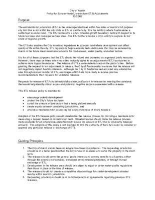
City of Austin Policy for Extraterritorial Jurisdiction (ETJ) Adjustments 10/02/07 Purpose The extraterritorial jurisdiction (ETJ) is the unincorporated land within five miles of Austin’s full purpose city limit that is not within the city limits or ETJ of another city. It is the territory where Austin alone is authorized to annex land. The ETJ represents a city’s potential growth boundary, both with respect to its future tax base and municipal service area. The ETJ further ensures a city’s ability to capture its fair share of regional growth. The ETJ also enables the City to extend regulations to adjacent land where development can affect quality of life within the city. ETJ regulations help to ensure that subdivisions that may be annexed by Austin in the future meet minimum standards for road access, water quality, and other factors. It is for all of these purposes that the ETJ should be valued and promoted as a general public resource. However, there may be times when two cities mutually agree to an adjustment of ETJ boundaries to achieve more logical boundaries. The release of ETJ is a discretionary act on the part of cities. Before granting the request for an adjustment or release, the City of Austin seeks to ensure that the release will not negatively impact Austin’s interests. Although the City of Austin has not acquired any substantive area through mutual transfer of ETJ, exchanges of ETJ are more likely to receive positive recommendations than requests for unilateral releases. Requests for release of ETJ should establish a clear justification for release by meeting the standards that would help identify critical issues and potential negative impacts associated with a release. This ETJ release policy is intended to: • encourage orderly development • protect the City’s future tax base • • • provide a mechanism for assessing the appropriateness of future requests. curtail the amount of jurisdiction that is being yielded annually create equity between competing jurisdictions, and Adoption of the ETJ release policy would standardize the release process by providing a mechanism for measuring a request based on its individual merit. Standardization should make the release process more equitable for all jurisdictions and effectively reduce the amount of ETJ that is voluntarily released annually. The adoption of this policy is not intended to limit the authority of the City Council to consider or approve any particular release or exchange of ETJ. Guiding Principles 1. …
WORKING DRAFT – SUBJECT TO CHANGE ORDINANCE NO. AN ORDINANCE AMENDING TITLE 25 (LAND DEVELOPMENT) OF THE CITY CODE ESTABLISHING REGULATIONS APPLICABLE TO PLANNED DEVELOPMENT AREA 2 (PDA2) ZONING AND ENDING THE ACCEPTANCE OF ZONING AND REZONING APPLICATIONS TO COMBINE PLANNED DEVELOPMENT AREA (PDA) COMBINING DISTRICT WITH CERTAIN BASE ZONES. BE IT ORDAINED BY THE CITY COUNCIL OF THE CITY OF AUSTIN: PART 1. Subsection (F) of City Code Section 25-2-32 (Zoning Districts and Map Codes) is amended to add new combining districts to read: (F) Combining districts and map codes are as follows: (25) planned development area 2….PDA2 PART 2. Division 6, Article 2, Subchapter A of City Code Chapter 25-2 (Zoning) is amended to add a new Section 25-2-183 to read: § 25-2-183 PLANNED DEVELOPMENT AREA 2 (PDA2) COMBINING DISTRICT PURPOSE AND BOUNDARIES. The purpose of a planned development area 2 (PDA2) combining district is to provide for certain industrial and commercial uses in industrial base districts. PART 3. Division 5, Article 3, Subchapter C of City Code Chapter 25-2 (Zoning) is amended to add a new Section 25-2-655 to read: § 25-2-655 PLANNED DEVELOPMENT AREA 2 (PDA2) COMBINING DISTRICT REGULATIONS. (A) A planned development area 2 (PDA2) combining district may be combined with the following base districts: (1) industrial park (IP); (2) limited industrial services (LI); (3) major industry (MI); and (4) research and development (R&D). PDA2 draft ordinance Page 1 of 3 COA Law Department 1 2 3 4 5 6 7 8 9 10 11 12 13 14 15 16 17 18 19 20 21 22 23 24 25 26 27 28 29 30 31 32 33 34 35 36 37 38 39 40 41 42 43 44 45 46 47 48 49 50 51 52 53 54 55 56 57 58 WORKING DRAFT – SUBJECT TO CHANGE (B) Regulations established by a PDA combining district may modify: (1) (2) (3) except for residential uses, permitted or conditional uses authorized in the base district; except for Subchapter C, Article 10 (Compatibility Standards), the site development regulations applicable in the base district; or off-street parking design or loading regulations, sign regulations, or landscaping or screening regulations applicable in the base district. (C) Modifications to the base district regulations must be identified in the ordinance zoning or rezoning property as a PDA2 combining district. (D) Planned development area 2 (PDA2) combining districts must comply with the standards …
C20-2024-017 PDA2 & Density Bonus for Commercial Highway & Industrial Zones (DB240) PLANNING PRESENTATION Alan Pani, Planner Principal Oct. 22, 2024 Background 1966 City Council first adopted the Planned Development Area land use with the following purpose: “to provide suitable and conducive environment for the development of modern administrative facilities, research establishments, specialized manufacturing plants, and similar enterprises plus retail and other customer service facilities… and not intrude upon nearby existing or future residential and associated development.” (page 21) adopted 2014-2024 Staff analysis of PDA zoning ordinances over the past decade shows an increase in cases where residential uses have been permitted. Since 2014, there have been 45 zoning ordinances which permitted residential uses, with 31 of those cases since 2020. 2024 City Council initiated Resolution No. 20240718-091, which directed the City Manager to: “create a new density bonus program that will apply to the PDA zoning district and allow increased heights for residential uses in exchange for income-restricted units or a fee-in-lieu.” Resolution No. 20240718-091 2 PDA Current PDA2 Proposed DB240 Proposed Allows: • Residential uses to be added • Commercial uses to be added • Modified site development standards • Modified heights • Modified FAR Allows: • Commercial uses to be added • Modified site development standards • Modified heights • Modified FAR Does not allow: • Residential uses to be added Base zones that can use PDA: • Commercial Highway (CH) Industrial Park (IP) • • Major Industry (MI) Light Industrial (LI) • • Research & Development (R&D) Base zones that can use PDA2: Industrial Park (IP) • • Major Industry (MI) Light Industrial (LI) • • Research & Development (R&D) Increased height to max. 240 feet Allows: • • Unlimited FAR Adds: • Residential uses • Specific commercial uses Amends: • Certain site development standards Requires: • Set-aside affordable housing units Base zones that can use density bonus: • Commercial Highway (CH) Industrial Park (IP) • • Major Industry (MI) Light Industrial (LI) • • Research & Development (R&D) 3 PDA2 – Purpose ▪ The purpose of a Planned Development Area 2 (PDA2) is to: – Allow for additional uses & revision of site development standards in: – Industrial Park (IP) – Major Industry (MI) – Light Industrial (LI) – Research & Development (RD) – CH cannot use new PDA2 – Cannot add residential uses – New applications for PDA not accepted after PDA2 is adopted …
C20-2024-017 ORDINANCE AMENDMENT REVIEW SHEET Amendment: C20-2024-017 Planned Development Area 2 (PDA2) & C20-2024-022 Density Bonus for Commercial Highway and Industrial Zones (DB240) Description: Amend City Code Title 25 (Land Development) to create a Planned Development Area 2 (PDA2) combining district and a Density Bonus for Commercial Highway and Industrial Zones (DB240) combining district. The PDA2 combining district is proposed to allow for modification of use and site development standards in certain commercial and industrial base districts. Under the proposal, additional residential uses would not be allowed under the PDA2 combining district. The Density Bonus for Commercial Highway and Industrial Zones (DB240) combining district is proposed to allow additional residential uses and modification of certain site development standards for residential uses in certain commercial and industrial base districts through a voluntary density bonus program. Under the proposal, PDA2 could be added to the IP, MI, LI, and R&D base zoning districts and DB240 could be added to the CH, IP, MI, LI, and R&D base districts. Moving forward, sites would no longer be able to rezone into PDA, but would need to request either PDA2 or the DB240. Background: Initiated by City Council Resolution No. 20240718-091. Planned Development Areas (PDA) were first added to the land development code in 1966 (19660616, City Council Meeting Minutes (austintexas.gov)) for the following purpose: “to provide suitable and conducive environment for the development of modern administrative facilities, research establishments, specialized manufacturing plants, and similar enterprises plus retail and other customer service facilities… and not intrude upon nearby existing or future residential and associated development.” (page 21) The use of a PDA allows for modifications to site development standards, including maximum height and floor-to-area ratio (FAR), as well as modifications to allowed and prohibited uses within a zoning district. On May 23rd, 2023, via Resolution No. 20230323-085, the City Council initiated an amendment to Land Development Code Section 25-2-582 (Commercial Highway (CH) District Regulations) to eliminate all the regulations found in 25-2-582(C) and clarify that a zoning ordinance establishing a CH-PDA controls over any conflicting CH regulations. This allowed for wider use of PDA zoning for Commercial Highway (CH) districts. Based on staff analysis of PDA zoning ordinances over the last ten years, there has been an increase in the number of cases where residential uses have been permitted: since 2014, 45 PDA zoning ordinances have permitted residential uses, with 31 of those cases since …
1 2 3 4 5 6 7 8 9 10 11 12 13 14 15 16 17 18 19 20 21 22 23 24 25 26 27 28 WORKING DRAFT – SUBJECT TO CHANGE ORDINANCE NO. AN ORDINANCE AMENDING TITLE 25 (LAND DEVELOPMENT) OF THE CITY CODE ESTABLISHING A DENSITY BONUS PROGRAM 240 (DB240) ZONING AND ASSOCIATED REGULATIONS. BE IT ORDAINED BY THE CITY COUNCIL OF THE CITY OF AUSTIN: PART 1. Subsection (F) of City Code Section 25-2-32 (Zoning Districts and Map Codes) is amended to add new combining districts to read: (F) Combining districts and map codes are as follows: (26) density bonus 240 ….DB240 PART 2. City Code Section 25-2-181 (Density Bonus Combining District Purpose) is amended to add a new Subsection (E) to read: § 25-2-181 DENSITY BONUS COMBINING DISTRICT PURPOSE. (E) DB240 combining district allows residential uses on sites with commercial highway and industrial base zoning districts, modifies site development regulations, and grants additional height in exchange for community benefits including income-restricted housing. PART 3. Division 5, Article 3, Subchapter C of City Code Chapter 25-2 (Zoning) is amended to add a new Section 25-2-656 to read: § 25-2-656 DENSITY BONUS 240 (DB240) COMBINING DISTRICT REGULATIONS. (A) This section establishes the applicable regulations for DB240 zoning. (B) This section governs over a conflicting provision of this title or other ordinance. (C) Pre-Requisites. (1) To utilize the regulations described in Subsection (G), a property must include DB240 zoning and an applicant must comply with Subsections (E) and (F). (2) To preserve reserved dwelling units and existing non-residential spaces, an applicant must comply with Article 2 (Density Bonus and Incentive DB240 draft ordinance Page 1 of 9 COA Law Department WORKING DRAFT – SUBJECT TO CHANGE Programs) of Chapter 4-18 before applying for a building permit or site plan that relies on the regulations described in Subsections (G). (D) A DB240 combining district may only be combined with the following base districts: (1) industrial park (IP); (2) limited industrial services (LI); (3) major industry (MI); (4) research and development (R&D); and (5) commercial highway services (CH). (E) Affordability Requirements – Dwelling Units. (1) In this subsection, BONUS HEIGHT means the amount of height that exceeds the height allowed by the base zoning district. (2) Affordability Minimums - Ownership Units. If an applicant develops dwelling units for sale, this subdivision applies. (a) To utilize 30 feet in bonus …
C20-2024-017 PDA2 & Density Bonus for Commercial Highway & Industrial Zones (DB240) PLANNING PRESENTATION Alan Pani, Planner Principal Oct. 22, 2024 Background 1966 City Council first adopted the Planned Development Area land use with the following purpose: “to provide suitable and conducive environment for the development of modern administrative facilities, research establishments, specialized manufacturing plants, and similar enterprises plus retail and other customer service facilities… and not intrude upon nearby existing or future residential and associated development.” (page 21) adopted 2014-2024 Staff analysis of PDA zoning ordinances over the past decade shows an increase in cases where residential uses have been permitted. Since 2014, there have been 45 zoning ordinances which permitted residential uses, with 31 of those cases since 2020. 2024 City Council initiated Resolution No. 20240718-091, which directed the City Manager to: “create a new density bonus program that will apply to the PDA zoning district and allow increased heights for residential uses in exchange for income-restricted units or a fee-in-lieu.” Resolution No. 20240718-091 2 PDA Current PDA2 Proposed DB240 Proposed Allows: • Residential uses to be added • Commercial uses to be added • Modified site development standards • Modified heights • Modified FAR Allows: • Commercial uses to be added • Modified site development standards • Modified heights • Modified FAR Does not allow: • Residential uses to be added Base zones that can use PDA: • Commercial Highway (CH) Industrial Park (IP) • • Major Industry (MI) Light Industrial (LI) • • Research & Development (R&D) Base zones that can use PDA2: Industrial Park (IP) • • Major Industry (MI) Light Industrial (LI) • • Research & Development (R&D) Increased height to max. 240 feet Allows: • • Unlimited FAR Adds: • Residential uses • Specific commercial uses Amends: • Certain site development standards Requires: • Set-aside affordable housing units Base zones that can use density bonus: • Commercial Highway (CH) Industrial Park (IP) • • Major Industry (MI) Light Industrial (LI) • • Research & Development (R&D) 3 PDA2 – Purpose ▪ The purpose of a Planned Development Area 2 (PDA2) is to: – Allow for additional uses & revision of site development standards in: – Industrial Park (IP) – Major Industry (MI) – Light Industrial (LI) – Research & Development (RD) – CH cannot use new PDA2 – Cannot add residential uses – New applications for PDA not accepted after PDA2 is adopted …
C20-2024-017 ORDINANCE AMENDMENT REVIEW SHEET Amendment: C20-2024-017 Planned Development Area 2 (PDA2) & C20-2024-022 Density Bonus for Commercial Highway and Industrial Zones (DB240) Description: Amend City Code Title 25 (Land Development) to create a Planned Development Area 2 (PDA2) combining district and a Density Bonus for Commercial Highway and Industrial Zones (DB240) combining district. The PDA2 combining district is proposed to allow for modification of use and site development standards in certain commercial and industrial base districts. Under the proposal, additional residential uses would not be allowed under the PDA2 combining district. The Density Bonus for Commercial Highway and Industrial Zones (DB240) combining district is proposed to allow additional residential uses and modification of certain site development standards for residential uses in certain commercial and industrial base districts through a voluntary density bonus program. Under the proposal, PDA2 could be added to the IP, MI, LI, and R&D base zoning districts and DB240 could be added to the CH, IP, MI, LI, and R&D base districts. Moving forward, sites would no longer be able to rezone into PDA, but would need to request either PDA2 or the DB240. Background: Initiated by City Council Resolution No. 20240718-091. Planned Development Areas (PDA) were first added to the land development code in 1966 (19660616, City Council Meeting Minutes (austintexas.gov)) for the following purpose: “to provide suitable and conducive environment for the development of modern administrative facilities, research establishments, specialized manufacturing plants, and similar enterprises plus retail and other customer service facilities… and not intrude upon nearby existing or future residential and associated development.” (page 21) The use of a PDA allows for modifications to site development standards, including maximum height and floor-to-area ratio (FAR), as well as modifications to allowed and prohibited uses within a zoning district. On May 23rd, 2023, via Resolution No. 20230323-085, the City Council initiated an amendment to Land Development Code Section 25-2-582 (Commercial Highway (CH) District Regulations) to eliminate all the regulations found in 25-2-582(C) and clarify that a zoning ordinance establishing a CH-PDA controls over any conflicting CH regulations. This allowed for wider use of PDA zoning for Commercial Highway (CH) districts. Based on staff analysis of PDA zoning ordinances over the last ten years, there has been an increase in the number of cases where residential uses have been permitted: since 2014, 45 PDA zoning ordinances have permitted residential uses, with 31 of those cases since …
Infill Plats & Site Plan Lite: Update on Staff Proposal Planning Commission| Oct. 22, 2024 Changes to Staff Proposal Since 08/27/2024 Commission Meeting Change Effect Revise Sec. 25-7-67 to increase site area for “no drainage review” tier for resubdivisions from 0.25 acres to 11,500 square feet. Facilitates re-subdivision into two HOME-1 lots and provides greater flexibility for re-subdividing into HOME-2 lots. TPW to implement a policy providing automatic relief from right-of-way dedication for infill projects on Level 1 streets that meet a few simple criteria. By eliminating requirement to obtain a waiver, this policy will help reduce review times and streamline the permitting process for infill projects. PARD to streamline process for approving payment of fee in-lieu for residential infill projects. Reduce review times and streamline the permitting process for infill projects. Recap of Staff Proposal: Infill Plats Example “Greenfield” Subdivision For scale: A ¼-acre area, eligible for streamlined resub per “Infill Plat” proposal Summary of Infill Plat Proposal: Drainage Code Amendments Lot Size Proposed Requirements for Resubdivision Additional Info. Up to 11.500 sq. ft. No drainage studies or onsite detention ponds Same as 1-4 units on a single lot No drainage studies or onsite detention ponds are required if these requirements are met: More than required for 1-4 units on a single lot, but less than a standard subdivision or site plan >11,500 sq. ft. to 1.0 acres Lot drains to street right-of- way (ROW) or storm drain without grading: Just a drainage map depicting direction of water flow No engineering or fee payment Grading is required to drain lot to ROW or storm drain: Compliance with Regional Stormwater Management Program (RSMP) Engineering & RSMP fee, as well as grading inspection >11,500 sq. ft. If the above requirements are not met, compliance with all applicable drainage regulations (Land Development Code & Drainage Criteria Manual) is required Required today for all re- subdivisions 6 Infill Plat Scenario 1: Lot no greater than 11,500 square feet HOME-1 Project (building permit) HOME-2 Project (subdivision with lots lines) No drainage studies or on- site detention ponds Same max. footprint as building permit/HOME-1 No difference in drainage requirements from surrounding 1-4 unit housing on single lots 7 Infill Plat Scenario 2: 11.5K sq. ft. to 1-acre lot with natural surface flows to road/drainage system Drainage map depicting direction of water flow No stormwater engineering, detention pond, or RSMP payment …
Case No. C20-2023-045 Planning Commission: October 22, 2024 ORDINANCE AMENDMENT REVIEW SHEET Amendment: C20-2023-045 | Site Plan Lite, Phase 2 & Infill Plats Amendment Introduction: This staff report discusses amendments to the Land Development Code (“LDC”) proposed in response to two separate council initiatives intended to facilitate construction of infill housing: Resolution No. 20221201-048 (“Site Plan Lite”) and Resolution No. 20230504-023 (“Infill Plats”). These amendments, which will be included in a single ordinance, seek to better calibrate non-zoning regulations and review procedures to the scale of “missing middle” housing. The report also describes changes initiated or under consideration by individual departments to address non-LDC related challenges to development of missing middle housing, including amendments to administrative criteria manuals and improvements to existing review procedures. Revisions to Original Proposal: Following the Planning Commission’s public hearing on August 27, 2024, staff continued to meet with stakeholders to discuss ways of improving the proposal to better address their concerns. As a result, staff’s proposal includes the following changes: • Under the revised proposal, residential re-subdivisions of up to 11,500 square feet are exempt from drainage review. This will provide greater flexibility than the originally proposed cap of a quarter-acre (10,890 square feet). • The Transportation and Public Works Department (TPW) is instituting a streamlined process for approving relief from right-of-way dedication requirements, which will make the process easier and quicker for most infill projects. • The Parks and Recreation Department (PARD) has committed to streamlining the process for approving payment of a fee-in-lieu of parkland dedication for infill projects that meet certain criteria, with the goal of greater predictability and a quicker review process. These changes are discussed in more detail throughout this report and, for easy reference, are flagged as “[UPDATED] or “[NEW].” {intentionally left blank} Case No. C20-2023-045 | Page - 1 Case No. C20-2023-045 Planning Commission: October 22, 2024 Amendment Background: — Site Plan Lite, Phase 2 On December 1, 2022, the City Council passed Resolution No. 20221201-048 initiating LDC amendments to better scale site plan review for residential projects of three to sixteen units located on a single lot. For Phase 1, Council adopted Ordinance No. 20230720-158 on July 20, 2023, creating a site plan exemption for projects of four or fewer residential units. This change, coupled with subsequent passage of the “HOME-1” ordinance, has enabled staff to conform the review process for three to four-unit residential projects more …
To: From: Chair Hempel Vice Chair Azhar Planning Commission Members Brent Lloyd Development Officer Development Services Department Date: October 18, 2024 Subject: Case No. C20-2023-045 |Response to Questions re: Infill Plats & Site Plan Lite, Pt. 2 To assist the Planning Commission in considering the above-referenced item, this memo provides staff responses to questions sent to us by a commissioner earlier this week. (Each question, quoted from the commissioner’s email, is followed by a staff response.) An interdepartmental staff team will be available to address additional questions at the Planning Commission’s October 22, 2024 meeting. “You mentioned previously, the current draft language is a result of ‘a lot of input Question 1. and discussion from stakeholders that have occurred over the last several months.’ Please let me know which stakeholders have agreed to this draft, specifically which environmental groups or any specifically focused on flood controls?” Response: of the proposal. In general: Staff cannot speak to which stakeholder groups support or oppose the latest version Stakeholders associated with environmental groups have expressed concerns regarding flooding impacts, particularly with respect to the “Site Plan Lite” portion of the proposal. Staff from the Watershed Protect Department have addressed these concerns on several occasions, including at two stakeholder engagement sessions, two Environmental Commission meetings, and a meeting of the Housing & Planning Committee. Stakeholders associated with the infill development community have expressed concerns that the proposal does not sufficiently relax regulations. While differences remain, staff has made numerous changes to address practical concerns raised by these stakeholders. As discussed in the staff report, these changes will help to increase flexibility and reduce costs for residential infill projects while maintaining existing floodplain and water quality protections. “In your previous presentation, you cite this proposal will streamline the Question 2. development process for approximately 3,500 sites. Is that the total universe of which properties could utilize this streamlined process? Or an estimated number who DSD believes will use the streamlined process?” Under the Site Plan Lite (“SP-Lite”) proposal, no engineered drainage analysis or Response: onsite detention facilities would be required for 5-16 projects if: (1) the site is no greater than 0.50 acres; and (2) the applicant provides a topographic drainage plan demonstrating that water flows naturally to the street or storm drain system. Providing engineered drainage analysis and onsite detention facilities can account for at least 30-40% of total costs, so projects that meet …
Affordability Impact Statement Infill Plats & Site Plan Lite, Phase 2 Initiated by: Resolution No. 20221201-048, 20230504-023 Case number: C20-2023-045 Date: October 21, 2024 Proposed Regulation The proposed amendments would do the following: Infill Plats • • • • Provides small-scale residential developments with a streamlined subdivision review process to facilitate fee-simple ownership of lots as an alternative to condominium regimes. • Aligns impervious cover assumptions used in the streamlined subdivision review with impervious cover limits imposed by zoning regulations, which will provide more flexible subdivision options, allowing landowners to create smaller lots without triggering full subdivision review. The modified drainage standards are limited to applications that meet the following criteria: Less than one acre in site area; o Not located within the Wildland Urban Interface; o Is within a previously platted residential subdivision; and o Does not require a plat vacation. Projects under 11,500 square feet are not required to provide a drainage study or onsite detention. Projects between 11,500 square feet and one acre must provide a drainage plan demonstrating that, without altering natural topography, stormwater will discharge to an existing storm drainage system or right-of-way. Site Plan Lite, Phase 2 • • • The modified drainage standards are limited to applications that meet the following criteria: o Less than 11,500 square feet in site area; and o 5 to 16 units on a single lot. • Qualifying projects must provide a drainage plan demonstrating that, without altering natural topography, stormwater will discharge to an existing storm drainage system or right-of-way. Establishes a new “small-project” category for developments of 5 to 16 units that qualify for the modified drainage standards, streamlining the review process with shorter review times and reduced fees. Land Use/Zoning Impacts on Housing Costs The proposed changes would have a positive impact on housing costs by facilitating the delivery of missing middle projects through a less onerous permitting process and by expanding options for “fee simple” ownership of units on separate lots rather than condominium regimes. Like Home I and Home II, this housing strategy is aimed at increasing attainable housing options for middle-income Austinites, which is supported by many of the Strategic Housing Blueprint and Imagine Austin Goals to encourage diverse housing types throughout Austin. The modified drainage standards apply only to areas outside the Wildland Urban Interface (WUI). However, further analysis and discussion are necessary to determine if these standards are entirely unavailable …
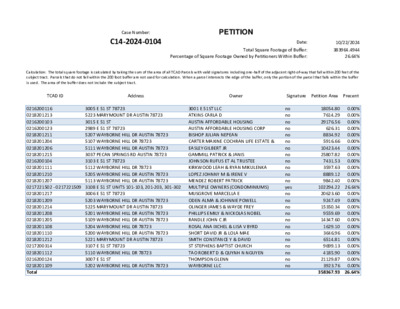
Case Number: C14-2024-0104 PETITION Total Square Footage of Buffer: Percentage of Square Footage Owned by Petitioners Within Buffer: Date: 10/22/2024 383964.4944 26.64% Calculation: The total square footage is calculated by taking the sum of the area of all TCAD Parcels with valid signatures including one-half of the adjacent right-of-way that fall within 200 feet of the subject tract. Parcels that do not fall within the 200 foot buffer are not used for calculation. When a parcel intersects the edge of the buffer, only the portion of the parcel that falls within the buffer is used. The area of the buffer does not include the subject tract. TCAD ID Address Owner Signature Petition Area Precent 3001 E 51ST LLC ATKINS CARLA D AUSTIN AFFORDABLE HOUSING AUSTIN AFFORDABLE HOUSING CORP BISHOP JULIAN NEPEAN CARTER MAXINE COCHRAN LIFE ESTATE & EASLEY GILBERT JR GAMMILL PATRICK & JANIS JOHNSON RUFUS ET AL TRUSTEE KIRKWOOD LEAH & RYAN MIKULENKA LOPEZ JOHNNY M & IRENE V MENDEZ ROBERT PATRICK 3005 E 51 ST 78723 5223 MARYMOUNT DR AUSTIN 78723 3015 E 51 ST 2989 E 51 ST 78723 5207 WAYBORNE HILL DR AUSTIN 78723 5107 WAYBORNE HILL DR 78723 5111 WAYBORNE HILL DR AUSTIN 78723 3037 PECAN SPRINGS RD AUSTIN 78723 3103 E 51 ST 78723 5112 WAYBORNE HILL DR 78723 5205 WAYBORNE HILL DR AUSTIN 78723 5113 WAYBORNE HILL DR AUSTIN 78723 0216200116 0218201213 0216200103 0216200123 0218201211 0218201204 0218201206 0218201215 0216200104 0218201111 0218201210 0218201207 0217221502 - 0217221509 3108 E 51 ST UNITS 101-103, 201-203, 301-302 MULTIPLE OWNERS (CONDOMINIUMS) 0218201217 0218201209 0218201214 0218201208 0218201205 0218201108 0218201110 0218201212 0217200314 0218201112 0216200124 0218201109 Total 3006 E 51 ST 78723 5203 WAYBORNE HILL DR AUSTIN 78723 5225 MARYMOUNT DR AUSTIN 78723 5201 WAYBORNE HILL DR AUSTIN 78723 5109 WAYBORNE HILL DR AUSTIN 78723 5204 WAYBORNE HILL DR 78723 5200 WAYBORNE HILL DR AUSTIN 78723 5221 MARYMOUNT DR AUSTIN 78723 3107 E 51 ST 78723 5110 WAYBORNE HILL DR 78723 3007 E 51 ST 5202 WAYBORNE HILL DR AUSTIN 78723 MUSGROVE MARCELLA E ODEN ALMA & JOHNNIE POWELL OLINGER JAMES & WAYDE FREY PHILLIPS EMILY & NICKOLAS NOBEL RANDLE JOHN C JR ROSAL ANA IXCHEL & LISA V BYRD SHORT DAVID JR & LOLA MAE SMITH CONSTANCE Y & DAVID ST STEPHENS BAPTIST CHURCH TAO ROBERT D & QUYNH N NGUYEN THOMPSON GLENN WAYBORNE LLC no no no no no no no no no no no no yes no no …
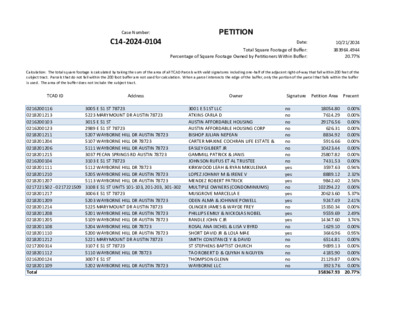
Case Number: C14-2024-0104 PETITION Total Square Footage of Buffer: Percentage of Square Footage Owned by Petitioners Within Buffer: Date: 10/21/2024 383964.4944 20.77% Calculation: The total square footage is calculated by taking the sum of the area of all TCAD Parcels with valid signatures including one-half of the adjacent right-of-way that fall within 200 feet of the subject tract. Parcels that do not fall within the 200 foot buffer are not used for calculation. When a parcel intersects the edge of the buffer, only the portion of the parcel that falls within the buffer is used. The area of the buffer does not include the subject tract. TCAD ID Address Owner Signature Petition Area Precent 3001 E 51ST LLC ATKINS CARLA D AUSTIN AFFORDABLE HOUSING AUSTIN AFFORDABLE HOUSING CORP BISHOP JULIAN NEPEAN CARTER MAXINE COCHRAN LIFE ESTATE & EASLEY GILBERT JR GAMMILL PATRICK & JANIS JOHNSON RUFUS ET AL TRUSTEE KIRKWOOD LEAH & RYAN MIKULENKA LOPEZ JOHNNY M & IRENE V MENDEZ ROBERT PATRICK 3005 E 51 ST 78723 5223 MARYMOUNT DR AUSTIN 78723 3015 E 51 ST 2989 E 51 ST 78723 5207 WAYBORNE HILL DR AUSTIN 78723 5107 WAYBORNE HILL DR 78723 5111 WAYBORNE HILL DR AUSTIN 78723 3037 PECAN SPRINGS RD AUSTIN 78723 3103 E 51 ST 78723 5112 WAYBORNE HILL DR 78723 5205 WAYBORNE HILL DR AUSTIN 78723 5113 WAYBORNE HILL DR AUSTIN 78723 0216200116 0218201213 0216200103 0216200123 0218201211 0218201204 0218201206 0218201215 0216200104 0218201111 0218201210 0218201207 0217221502 - 0217221509 3108 E 51 ST UNITS 101-103, 201-203, 301-302 MULTIPLE OWNERS (CONDOMINIUMS) 0218201217 0218201209 0218201214 0218201208 0218201205 0218201108 0218201110 0218201212 0217200314 0218201112 0216200124 0218201109 Total 3006 E 51 ST 78723 5203 WAYBORNE HILL DR AUSTIN 78723 5225 MARYMOUNT DR AUSTIN 78723 5201 WAYBORNE HILL DR AUSTIN 78723 5109 WAYBORNE HILL DR AUSTIN 78723 5204 WAYBORNE HILL DR 78723 5200 WAYBORNE HILL DR AUSTIN 78723 5221 MARYMOUNT DR AUSTIN 78723 3107 E 51 ST 78723 5110 WAYBORNE HILL DR 78723 3007 E 51 ST 5202 WAYBORNE HILL DR AUSTIN 78723 MUSGROVE MARCELLA E ODEN ALMA & JOHNNIE POWELL OLINGER JAMES & WAYDE FREY PHILLIPS EMILY & NICKOLAS NOBEL RANDLE JOHN C JR ROSAL ANA IXCHEL & LISA V BYRD SHORT DAVID JR & LOLA MAE SMITH CONSTANCE Y & DAVID ST STEPHENS BAPTIST CHURCH TAO ROBERT D & QUYNH N NGUYEN THOMPSON GLENN WAYBORNE LLC no no no no no no no no no yes yes yes no yes yes …
310 Inner Campus Drive, B7500 Austin, Texas 78712-1009 T: 512.471.1922 F: 512.471.0716 soa.utexas.edu October 22, 2024 Dear Commissioners, I am writing to express my concern about the proposal to add residential uses to areas zoned for Commercial Highways, and for a variety of high intensity industrial uses. A recent report published by the American Planning Association summarizes a decade of research conducted by the EPA detailing the connections between ambient pollutants coming from highways and industrial facilities and health outcomes including cancers, fertility disorders, kidney diseases, stroke, lung cancers or diseases, lower life expectancy, thyroid disorders, depression, autoimmune conditions, and the leading cause of death in the United States: cardio-vascular disease (Quattro 2024, pg 28). For the past two years I have been working with an interdisciplinary team at UT on a study of the relationship between neighborhood air quality and asthma, under a grant funded by the National Institutes of Health. The team is led by Elizabeth Matsui, MD, at the Dell Medical School and includes experts in air pollution/air quality and in health conditions resulting from exposure to pollutants, including asthma. The team has been studying the relationship between neighborhood air quality and trips to the emergency room for acute asthma. The study was motivated by a desire to explain the disparately high levels of asthma experienced by people of color in Travis County. In 2017, 8 times as many black children, and 2.5 times as many Latinx children were hospitalized for asthma, compared to rates for white children. And people coming to the emergency room for treatment for asthma were concentrated in a subset of Austin neighborhoods. Highways and industrial facilities are key sources of the pollutants linked to asthma. My colleague, Dr. Alex Karner, has published a review of the existing literature on the connection between exposure to pollutants from highways and health. I include his letter giving you the key points from his review. There is widespread agreement that placing residential uses or uses for sensitive populations next to highways is a bad idea. While there are strategies for mitigating the impacts of exposure, they are second best options. The first best is not to place these uses alongside highways. A recent study from the Urban Institute documents the disproportionate siting of MF housing close to highways in Los Angeles and makes recommendations aimed at preventing co-location of housing and highways, and for reducing dependence …
Residential Infill Subdivision and Site Plan Lite Recommendations The AIC and HBA appreciate the opportunity to offer recommendations on ways to improve the subdivision process for much needed missing middle and infill housing. These projects will bring gentle density to Austin by making the subdivision process more efficient and using Austin’s limited developable land more efficiently. Prior to 1984, these types of projects were common and are heralded today as some of Austin’s most affordable housing stock. Change is difficult, and the development process is complicated. We understand that many of the necessary changes will require thoughtful, in-depth analysis and compromise among city departments and city priorities. Ultimately, housing affordability and housing supply should be the guiding priority. We hope that the city and its departments will come to the table and work with the development community to find solutions that will improve the process while maintaining a high standard of construction and safety. Several departments have already made good efforts to improve their processes. We hope these recommendations will build on those efforts. In this report, we offer two separate sets of recommendations for residential infill subdivision and site plan lite, broken down by department. These lists of recommendations illustrates the need change in almost every department involved in the development process. These recommendations are not exhaustive but are designed to be a starting point for improvements. In the recommendations, you will also find our goals and guiding principles that helped shape our recommendation. Some of these recommendations will require changes to the land development code while others will require edits to the city’s criteria manuals or administrative processes. While there is some overlap between the two, after diving into our recommendations in greater detail, we have come to agreement that residential infill subdivision and site plan lite should be considered separately. The two different processes present different challenges as projects increase in size. In order to improve the site plan and subdivision process globally, the city must: • One of the biggest barriers to missing middle housing is the time it takes for approval. Establishing reasonable and achievable goals for review times will encourage simplification and process improvements. • Modify applicable regulations and processes for predictability, consistency and increased • • feasibility for compliance. Implement a speedy resolution process for inter departmental conflicts. Identify and publish applicable regulations across departments so applicants can get it right with their …
Residential Infill Subdivision Goal: To create an efficient process for residential infill subdivision, allowing for the creation of fee simple lots in existing neighborhoods on legal tracts with existing drainage patterns, and established utilities and services. A streamlined infill lot process will allow either fee simple ownership, or condo form of ownership with densities, lot sizes, and impervious cover limits already allowed under existing zoning. The Primary goal is for missing middle sites to be treated in proportion to their size and have clear, upfront rules. The current process is subjective with open-ended negotiations, inequitable costs, and lengthy review times. Applies to: Previously platted lots, or land status qualifying lots, under one acre and zoned for residential use. LDC SUGGESTED EDITS BY DEPARTMENT Austin Energy • Reduce aerial setback from 15 ft to 10 ft for infill plats. • Only require easements to accommodate existing facilities or to bring service to the lots. Increase minimum distance from right of way that triggers sprinklers in residential units. Austin Fire • • Allow for multiple units to be served by one driveway. • Reduce aerial setback from 15 ft to 10 ft for infill plats Austin Water • • Add flexibility for lot line crossing per uniform plumbing code. 25-9-33 (F) - No Service Extension is required for re-plats six lots or less and under one acre if flow rate and capacity is sufficient. • Create templated Joint Use Access agreements and set timeline goal of seven day turn around for plats. City Legal Development Services • • • • Establish review timeline goal - 60 Days from submission to completion, including 30 Days Shot Clock State Rule 212.009. Benchmark these goals with other similar cities. 25-4-1 - Infill Plats are not subject to 25-7 (drainage) and 25-8 (water quality, environmental). 25-4-1 (D) - An existing legal tract may be re-platted to include up to six lots or less and under one acre without triggering traditional subdivision review 25-4-1 (D)(1) - Additional plat notes that simply mimic existing code will not be required for re-plats six lots or less and under one acre that do not vacate original plat. New plat notes shall be provided in a standardized form. • 25-4-34 (F) - Original Tract requirement does not apply to infill plats (replats six lots or less and under one acre). • 25-4-84 (E) - Fiscal Surety and Engineer's cost estimate is …
Site Plan Lite Goal: To create an efficient process for Site Plan Lite to accommodate missing middle residential projects up to 16 units where allowed by zone that can be approved quickly and efficiently. The site plan light review process for missing middle should closely mirror the review process for similarly sized projects under HOME 1 that utilize a condo regime. The primary goal is for missing middle sites to be treated in proportion to their size and have clear, upfront rules. The current process is subjective with open-ended negotiations, inequitable costs, and lengthy review times. There is a tremendous difference between obtaining permits for two or three units on a property compared to 5-16 units. Applies to: Properties able to accommodate 16 units by zone, up to two acres. It’s critical that the size of the tract be large enough to achieve up to 16 units while also accommodating site conditions like trees and topography. List of recommended changes by department Austin Energy • Reduce aerial setback from 15 ft to 10 ft for infill plats. Austin Water • • Add flexibility for lot line crossing per uniform plumbing code. 25-9-33 (F) No Service Extension is required for re-plats 6 lots or less and under one acre if flow rate and capacity is sufficient City Legal Development Services • Create templates for Joint Use Access and other easement agreements. • • Allow unified processing of easements at a legal “one stop shop.” Track legal approvals in Amanda and in the approval timeline, including response times and customer service information. • • • 25-5-3 - Small Projects. Include provision that any site plan that proposes 5-16 units is qualified as a Small Project. 25-5-21 - Phased Site Plans. Any site that proposes 5-16 units is not required to phase the site plan to allow for individual buildings to gain a separate certificate of occupancy. A site plan with 5-16 units is not required to break out phases for compliance for any code requirement. The Site Plan shall comply with all code requirements as a whole property and not by phase, regardless of the pace of construction. 25-5-62 - Site Plan Extensions. A site plan with 5-16 units may be extended by the Director for a period up to five years without any additional requirements. Environmental and Community Trees 25-8-211 (G) - Fee in Lieu for Water Quality shall be allowed. …
10431 Morado Circle, Suite 300 Austin, Texas 78759 512-617-3100 fax 512-617-3101 www.freese.com TECHNICAL MEMORANDUM TO: Reem Zoun, PE, CFM FROM: SUBJECT: Garrett Johnston, PE, CFM, GISP Kim Patak, PE, CFM, ENV SP CodeNEXT Flood Mitigation Analysis (West Bouldin/Del Curto) PROJECT: AU316288 – WBO WMP Phase II DATE: February 9, 2018 CC: Rupali Sabnis, PE, CFM 1.00 BACKGROUND DRAFT THIS DOCUMENT IS RELEASED FOR THE PURPOSE OF INTERIM REVIEW UNDER THE AUTHORITY OF JOHN GARRETT JOHNSTON, P.E., TEXAS NO. 115779 ON FEBRUARY 9, 2018. IT IS NOT TO BE USED FOR CONSTRUCTION, BIDDING OR PERMIT PURPOSES. FREESE AND NICHOLS, INC. TEXAS REGISTERED ENGINEERING FIRM F- 2144 The City of Austin (COA) is currently in the process of updating the land development code through a process called CodeNEXT. As part of this effort, the City’s Watershed Protection Department (WPD) is considering changes to flood mitigation requirements. To quantify the flood risk reduction effects of these potential criteria changes, Freese and Nichols, Inc. (FNI) was retained by WPD to perform a case study in the West Bouldin Creek (WBO) watershed. The study area for this task centers on Del Curto Road near South Lamar Boulevard, a primarily residential area that receives runoff from a combination of residential and commercial properties upstream. The study area is generally bounded by Ann Arbor Avenue, Rabb Glen Street, Thornton Road, and Cinnamon Path. Storm runoff from the area is collected into a storm drain system which outfalls just downstream of Thornton Road into a channel that drains to West Bouldin Creek. WPD has received several reports of flooding in this area, as shown in the attached figures. 2.00 HYDROLOGIC AND HYDRAULIC MODELING The study area was evaluated using Innovyze’s InfoWorks Integrated Catchment Modeling (ICM) 7.0 software, the City’s standard two-dimensional (2D) modeling platform. It was chosen for the study area due to its ability to evaluate a complex combination of storm drain systems and surface flow patterns. 2.01 DATA RECEIVED FROM WPD The following information was provided by the City’s WPD for use in the evaluation. 1. Flooding Complaints. WPD provided a point shapefile detailing 68 flood complaints in the Del Curto area. These are generally categorized as building, street, and yard flooding and include addresses and detailed notes. Refer to the attached figures for a depiction of locations and flood type. 2. ICM Models. The initial ICM models that FNI received, including a …
The Planning Commission convened in a regular meeting on Tuesday, October 22, 2024, at Austin City Hall, Council Chambers, Room 1001, 301 W. Second Street, in Austin, Texas. Chair Hempel called the Planning Commission meeting to order at 6:06 p.m. Board Members/Commissioners in Attendance: PLANNING COMMISSION REGULAR MEETING MINUTES TUESDAY, OCTOBER 22, 2024 Claire Hempel Greg Anderson Nadia Barrera-Ramirez Casey Haney Adam Haynes Felicity Maxwell Alberta Phillips Danielle Skidmore Alice Woods Awais Azhar Grayson Cox Patrick Howard Ryan Johnson Danielle Skidmore Board Members/Commissioners absent: PUBLIC COMMUNICATION: GENERAL Angela Garza, DB90 Bobby Levinski, Hays Commons 1 Board Members/Commissioners in Attendance Remotely: APPROVAL OF MINUTES 1. Approve the minutes of the Planning Commission regular meeting on October 8, 2024. The minutes from the meeting of October 8, 2024, were approved on the consent agenda on Commissioner Woods’ motion, Commissioner Maxwell’s second, on a 13-0 vote. PUBLIC HEARINGS Location: 2. Plan Amendment: NPA-2024-0027.01 - Rawson Saunders - Tarrytown Christian Church Improvements; District 10 2614 and 2614 ½ Exposition Boulevard, 2702 McCoullugh Street, 2615 ½ and 2611 Hillview Road, Taylor Slough South Watershed; Central West Austin Combined (West Austin) Neighborhood Planning Area Owner/Applicant: Austin Area School For Dyslexics Inc./Tarrytown Baptist Church Agent: Request: Staff Rec.: Staff: Thrower Design, LLC (Ron Thrower & Victoria Haase) Single Family to Mixed Use/Office land use Applicant postponement request to December 17, 2024 Maureen Meredith, 512-974-2695, maureen.meredith@austintexas.gov Planning Department The motion to approve the Applicant’s postponement request to December 17, 2024, was approved on the consent agenda on Commissioner Woods’ motion, Commissioner Maxwell’s second, on a 13-0 vote. 3. Rezoning: Location: C14-2024-0051 - Rawson Saunders - Tarrytown Christian Church Improvements; District 10 2614 and 2614 ½ Exposition Boulevard, 2702 McCoullugh Street, 2615 ½ and 2611 Hillview Road, Taylor Slough South Watershed; Central West Austin Combined (West Austin) Neighborhood Planning Area Owner/Applicant: Austin Area School For Dyslexics Inc./Tarrytown Baptist Church Agent: Request: Staff Rec.: Staff: Thrower Design, LLC (Ron Thrower & Victoria Haase) SF-3-NP to GO-MU-NP Applicant postponement request to December 17, 2024 Cynthia Hadri, 512-974-7620, cynthia.hadri@austintexas.gov Planning Department The motion to approve the Applicant’s postponement request to December 17, 2024, was approved on the consent agenda on Commissioner Woods’ motion, Commissioner Maxwell’s second, on a 13-0 vote. 2 4. Plan Amendment: NPA-2023-0017.01 - Anderson Square, District 4 Location: 910, 912, 914 & 916, 1012 & 1012 ½, 1100, 1100 ½ & 1102 ½ W. Anderson Lane, 7905 ½, 8003, …