04-2: TPL ParkScore Index Austin TX 2025 — original pdf
Backup
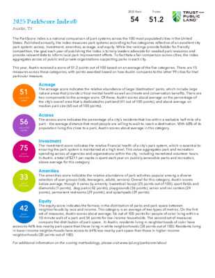
2025 ParkScore Index® Austin, TX 2025 Rank Points 54 51.2 The ParkScore index is a national comparison of park systems across the 100 most populated cities in the United States. Published annually, the index measures park systems according to five categories reflective of an excellent city park system: access, investment, amenities, acreage, and equity. While the rankings provide fodder for friendly competition, the goal each year of publishing the index is to help leaders advocate for needed park resources and provide relevant data to inform local park improvement efforts. To facilitate a fair comparison across cities, the index aggregates across all public and private organizations supporting parks in each city. This year, Austin received a score of 51.2 points out of 100 based on an average of the five categories. There are 15 measures across these categories, with points awarded based on how Austin compares to the other 99 cities for that particular measure. 51 out of 100 points 56 out of 100 points 75 out of 100 points 33 out of 100 points 42 out of 100 points Acreage The acreage score indicates the relative abundance of large ‘destination’ parks, which include large natural areas that provide critical mental health as well as climate and conservation benefits. There are two components to the acreage score. Of these, Austin scores about average on the percentage of the city’s overall area that is dedicated to parkland (41 out of 100 points), and about average on median park size (60 out of 100 points). Access The access score indicates the percentage of a city’s residents that live within a walkable half-mile of a park – the average distance that most people are willing to walk to reach a destination. With 68% of its population living this close to a park, Austin scores about average in this category. Investment The investment score indicates the relative financial health of a city’s park system, which is essential to ensuring the park system is maintained at a high level. This value aggregates park and recreation spending across all agencies and organizations within the city, including monetized volunteer hours. In Austin, a total of $211 per capita is spent each year on publicly accessible parks and recreation, above average for this category. Amenities The amenities score indicates the relative abundance of park activities popular among a diverse selection of user groups (kids, teenagers, adults, seniors). Overall for this category, Austin scores below average, though it varies by amenity: basketball hoops (25 points out of 100), sport fields and diamonds (1 points), dog parks (42 points), playgrounds (36 points), senior and rec centers (24 points), permanent restrooms (29 points), and splashpads (39 points). Equity The equity score indicates the fairness in the distribution of parks and park space between neighborhoods by race and income. This category is an average of two types of metrics. On the first set of measures, Austin scores about average: 56 out of 100 points for people of color living within a 10-minute walk of a park and 54 points for low-income households. The second set of measures compare the distribution of park space. In Austin, residents living in neighborhoods of color have access to 46% less nearby park space than those living in white neighborhoods (38 points out of 100). Residents living in lower-income neighborhoods have access to 64% less nearby park space than those in higher-income neighborhoods (20 points out of 100). For additional information on the scoring methodology, please visit www.tpl.org/parkscore/about 2025 ParkScore Index® Austin, TX 2025 Rank Points 54 51.2 City-wide total Values for Austin, TX: City-wide ‘per capita’ City-wide score* Acreage (51 Points) Parkland as a percentage of city area Median Park Size Access (56 Points) 18,437 acres 6.7 acres 9.0% of city area 6.7 acres Percent of population within a 10-minute walk of a park with public access 68% Equity (42 Points) Percent of people of color within a 10-minute walk of a park Percent of low-income households within a 10- minute walk of a park Residents in neighborhoods of color have _____ park space as those in white neighborhoods Low-income neighborhoods have _____ park space as those in high-income neighborhoods 68% 69% 46% less 64% less 41 points 60 points 56 points 56 points 54 points 38 points 20 points Value needed for: 1 pt 100 pts 2.5% 18.6% .58 11 28% 100% 28% 100% 32% 100% 89% less 85% less 25% more 25% more Investment (75 Points) Annual park investment (three-year average) Amenities (33 Points) Basketball hoops Sport fields Dog parks Playgrounds Senior/Rec centers Restrooms Splashpads $211,112,894 $ 211 per resident 75 points $44 $266 235 hoops 100 fields/diamonds 13 dog parks 217 playgrounds 25 centers 116 restrooms 11 splashpads 2.31 per 10,000 residents 0.98 per 10,000 residents 1.28 per 100,000 residents 10.05 per 10,000 children 0.49 per 20,000 residents 1.14 per 10,000 residents 5.10 per 100,000 children 25 points 1 points 42 points 36 points 24 points 29 points 39 points .63 7.29 .96 5.39 .32 2.62 2.78 23.16 .17 1.52 .30 3.18 .35 12.43 *For each of the 15 measures, cities are scored on a 1-100 scale (100 is the highest) relative to the other 99 cities. To adjust for outliers, 100 points is awarded for any city that has more than double the national median for that measure. The amenity average excludes the lowest scoring amenity. The Access category of the ParkScore index awards points based on the percentage of the populationwithin a 10-minute walk of a public park. This analysis is provided via the ParkServe mappingapplication, which identifies the population living within a 10-minute walk of a park by creatingdynamic 1/2-mile service areas (10-minute walking distance) for all public parks. In this analysis,service areas use the street network to determine walkable distance (streets such as highways,freeways, and interstates are considered barriers).In Austin, 68% of the population lives within a 10-minute walk of a park. Among the remaining322,039 people without access to a nearby park, Trust for Public Land suggests where to prioritize thedevelopment of new parks to reduce this gap. This prioritization is based on a comprehensive index ofsix equally-weighted demographic and environmental metrics.Special thanks to the following data providers: Austin, Esri, OSM, CDC, EPA. Information on this map isprovided for purposes of discussion and visualization only. Map created by Trust for Public Land on April15, 2025. Trust for Public Land and Trust for Public Land logo are federallyregistered marks of Trust for Public Land. Copyright © 2025 Trust for Public Land.www.tpl.org£¤183£¤290£¤79UV21UV95UV973UV734UV620UV71UV969UV3238UV1826§¨¦352025 ParkScore index: AccessPriority areas for new parks(outside of 10-minute walk service areas of parks with public access)Very high priorityHigh priorityModerate priorityPark with public accessOther park or open space10-minute walk (half-mile) service area ofpark with public accessCemeteryUniversityMilitaryIndustrialVacant zero population areaCity boundaryCounty boundary03.57Miles±®®AUSTIN, TEXAS• Population density*• Density of low income households (households with income less than 75% of the urban areamedian income; less than $72,000 in Austin)*• Density of people of color*• Community health (a combined index based on the rate of poor mental health and low physicalactivity from the 2024 CDC PLACES census tract dataset)• Urban heat islands (surface temperature at least 1.25 degrees greater than city mean surfacetemperature from Trust for Public Land, based on Landsat 8 satellite imagery)• Pollution burden (air toxics respiratory hazard index from 2024 EPA EJScreen)*Derived from 2024 forecast census block points produced by Esri.®The six metrics on which the prioritization is based: Special thanks to the following data providers: Austin, Esri, OSM, CDC, EPA. Information on this map isprovided for purposes of discussion and visualization only. Map created by Trust for Public Land on April15, 2025. Trust for Public Land and Trust for Public Land logo are federallyregistered marks of Trust for Public Land. Copyright © 2025 Trust for Public Land.www.tpl.org£¤290£¤183£¤79UV973UV734UV620UV71§¨¦35£¤290£¤183£¤79UV973UV734UV620UV71§¨¦35RaceIncomeBlock Group with higher % of people of colorBlock Group with higher % white populationBlock Group with higher % of low-income householdsBlock Group with higher % of high-income householdsPark with public accessOther park or open spaceCemeteryUniversityMilitaryIndustrialVacant zero population areaCity boundaryCounty boundaryPark acres per personVery highHighModerateLowVery low024Miles±®2025 ParkScore index: Equity®AUSTIN, TEXASThe Equity category of the ParkScore index awards points in part based on the difference in nearbypark space between neighborhoods in a city:•On a per person basis, ratio of nearby public park space between communities of color and whitecommunities•On a per person basis, ratio of nearby public park space between low-income communities andhigh-income communitiesNearby park space per person effectively measures the available park space within a 10-minute walkof a micro-neighborhood, identified by the set of block groups containing the 20% of the citypopulation with the highest concentrations of people of color or white population and high-incomeor low-income households. Households with income less than 75% of city median income (less than$72,000 in Austin) are considered low-income; households with income greater than 125% of citymedian income (greater than $120,000 in Austin) are high-income.In Austin, neighborhoods of color have 46% less park space than white neighborhoods, and low-income neighborhoods have 64% less than high-income neighborhoods.The metrics for people of color reflect each of the Census-designated race/ethnicity groups: Black,Hispanic, and Indigenous and Native American, Asian Americans, Pacific Islanders, multiple races, andother communities of color.Demographic profiles are derived from 2024 forecast census block points provided by Esri.