20260520-004, Impervious Cover in Montopolis — original pdf
Backup
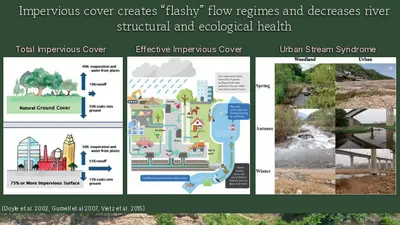
Impervious cover creates “flashy” flow regimes and decreases river structural and ecological health Total Impervious Cover Effective Impervious Cover Urban Stream Syndrome (Doyle et al. 2002, Gurnell et al 2007, Vietz et al. 2015) Total Impervious Cover in the LCR ➢ Fractional Impervious Cover Raster ○ Annual National Land Cover Database (NLCD) Montopolis Control Site vs Urban Sites How do impervious surfaces impact water quantity? Bull Creek Normal Flow Bull Creek Storm Flow Now imagine replacing the trees with concrete… Definition of impervious cover → Climate: UHE → Water: quality → Water: quantity Urban Growth Altered Hydrology Water Quality Decline Biological Impacts Urban Stream Syndrome Increase in impervious cover + Loss of vegetation and soil Increased runoff from roadways + Reduced infiltration and filtering Increased pollutant load Toxicity from pollutants reduces biodiversity Degraded urban streams Definition of impervious cover → Climate: UHE → Water: quality → Water: quantity How do impervious surfaces impact water quality? sensitive - potential to have a high stream quality (0-10% impervious cover) impacted - lose some species (10- 25% impervious cover) non supporting - species very impacted (25-60% impervious cover) urban drainage - nothing lives there (60-100% impervious cover) (Center for Study of Watershed Protection) Definition of impervious cover → Climate: UHE → Water: quality → Water: quantity How does urbanization create Urban Heat Island? Bull Creek Shoal Creek - Replacement of natural shade, soil, water bodies which all have natural cooling effects - Added heat from human activities - Urban “canyons” trap heat - Impervious surfaces Definition of impervious cover → Climate: UHE → Water: quality → Water: quantity Red = Vegetation High Summer Average Surface Temperature (°F) Austin’s Urban Core 97 – 100 101 – 104 105 – 108 109 - 112 0 16 km Map created by Chloe Ames for the CoA Heat Resilience Playbook