20260506-003, SoLa Mixed Use, SP-2024-0397C Appendix Q-4 — original pdf
Backup
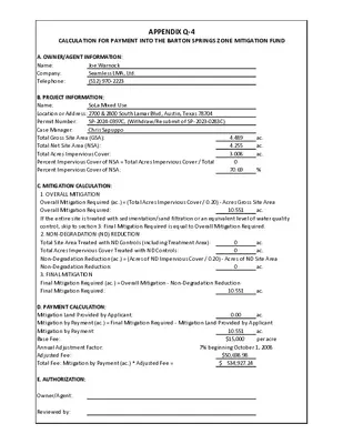
APPENDIX Q-4 CALCULATION FOR PAYMENT INTO THE BARTON SPRINGS ZONE MITIGATION FUND A. OWNER/AGENT INFORMATION: Joe Warnock Name: Seamless LMA, Ltd. Company: (512) 970-2223 Telephone: SoLa Mixed Use B. PROJECT INFORMATION: Name: Location or Address: 2700 & 2800 South Lamar Blvd, Austin, Texas 78704 Permit Number: Case Manager: Total Gross Site Area (GSA): Total Net Site Area (NSA): Total Acres Impervious Cover: Percent Impervious Cover of NSA = Total Acres Impervious Cover / Total Net Site Area Percent Impervious Cover of NSA: SP-2024-0397C, (Withdraw/Resubmit of SP-2023-0283C) Chris Sapuppo 4.489 4.255 3.008 0 70.69 ac. ac. ac. % C. MITIGATION CALCULATION: 1. OVERALL MITIGATION Overall Mitigation Required (ac.) = (Total Acres Impervious Cover / 0.20) - Acres Gross Site Area Overall Mitigation Required: If the entire site is treated with sedimentation/sand filtration or an equivalent level of water quality control, skip to section 3. Final Mitigation Required is equal to Overall Mitigation Required. 2. NON-DEGRADATION (ND) REDUCTION Total Site Area Treated with ND Controls (including Treatment Area): Total Acres Impervious Cover Treated with ND Controls: Non-Degradation Reduction (ac.) = (Acres of ND Impervious Cover / 0.20) - Acres of ND Site Area Non-Degradation Reduction: 3. FINAL MITIGATION Final Mitigation Required (ac.) = Overall Mitigation - Non-Degradation Reduction Final Mitigation Required: 10.551 10.551 ac. ac. 0 0 ac. ac. ac. 0 D. PAYMENT CALCULATION: Mitigation Land Provided by Applicant: Mitigation by Payment (ac.) = Final Mitigation Required - Mitigation Land Provided by Applicant Mitigation by Payment: Base Fee: Annual Adjustment Factor: Adjusted Fee: Total Fee: Mitigation by Payment (ac.) * Adjusted Fee = 10.551 $15,000 7% beginning October 1, 2008 $50,698.98 $ 534,927.24 0.00 ac. per acre ac. E. AUTHORIZATION: Owner/Agent: Reviewed by: APPENDIX Q-1 NET SITE AREA NOTE: NET SITE AREA IS ONLY APPLICABLE TO WATERSHEDS CLASSIFIED AS WATER SUPPLY SUBURBAN / WATER SUPPLY RURAL / BARTON SPRINGS ZONE (BSZ) TOTAL SITE AREA DRAINING TO BSZ = 4.489 ACRES SITE DEDUCTIONS CRITICAL WATER QUALITY ZONE (CWQZ) = WATER QUALITY TRANSITION ZONE (WQTZ) = WASTEWATER IRRIGATION AREAS = 0.000 ACRES 0.000 ACRES 0.000 ACRES DEDUCTION SUBTOTAL = 0.000 ACRES UPLAND AREA (GROSS SITE AREA MINUS TOTAL DEDUCTIONS) = 4.489 ACRES NET SITE AREA CALCULATION AREA OF UPLANDS WITH SLOPES 0-15% = AREA OF UPLANDS WITH SLOPES 15-25% = AREA OF UPLANDS WITH SLOPES 25-35% = AREA OF UPLANDS WITH SLOPES > 35% = 4.172 x 100% = 0.178 x 40% = 0.059 x 20% = 0.080 x 0% = NET SITE AREA TOTAL = 4.172 ACRES 0.071 ACRES 0.012 ACRES 0.000 ACRES 4.255 ACRES Source: Rule No. R161-14.23, 9-2-2014 EXISTING BSZ IC (BARTON CREEK WATERSHED) PROPOSED BSZ IC (BARTON CREEK WATERSHED) EXISTING URBAN IC (WEST BOULDIN CREEK WATERSHED) PROPOSED URBAN IC (WEST BOULDIN CREEK WATERSHED) SF 141,164 131,026 25,554 17,116 AC 3.241 3.008 0.587 0.393