20260415-003, Rain to River Strategic Plan Final Draft Part 2 — original pdf
Backup
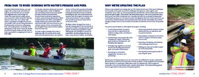
FROM RAIN TO RIVER: WORKING WITH WATER’S PROMISE AND PERIL WHY WE’RE UPDATING THE PLAN At Austin Watershed Protection, our work begins with a drop of rain and follows its journey across the land, into our streets and neighborhoods, and through the creeks that shape Austin’s people, places, and ecosystems. Water brings life, offering spaces to swim, fish, and connect with nature, nourishing our neighborhoods and local wildlife. Rain can also bring devastation, flooding streets and homes, endangering lives, and creating stress, uncertainty, and lasting harm. Every storm carries this duality (promise and peril, vitality and risk) and our work is grounded in navigating both sides of that reality. For decades, decisions about how to protect and manage Austin’s creeks, floodplains, and stormwater infrastructure were guided primarily by technical assessments, environmental monitoring, engineering models, and permitting requirements. While essential, these tools often overlooked the equally vital human systems that define watershed health: the social, historical, and cultural contexts of the communities that live alongside these waters and the realities they face every day. The Rain to River Strategic Plan marks a deliberate shift. We cannot do this work with technical expertise alone; we need the wisdom of those who experience flooding, erosion, and water pollution firsthand. By treating lived experience and community knowledge as data, we combine technical expertise with the insights of residents and community leaders to create strategies that are both practical and responsive to community needs. The Rain to River Strategic Plan charts a forward-looking path for the next decade. It responds to Austin’s changing climate, rapid growth, and the pressing need for equity, setting goals and strategies to ensure our watersheds—and the people who rely on them—are protected, resilient, and healthy. When we last updated our strategic plan in 2016, Austin faced many of the same challenges we see today. In the years since, those challenges have grown in scale, urgency, and complexity. Since 2016, our city has experienced severe floods, extreme heat, winter storms, and prolonged drought. These events had devastating impacts, with some Austinites losing their homes and others losing their lives. Population growth has accelerated development, increasing the pressure on our natural systems and aging infrastructure. At the same time, our community’s understanding of environmental justice and climate vulnerability has evolved, bringing a sharper focus on who benefits from public investment and who bears the greatest risks. Our previous plan helped us make significant progress, including: • Constructing hundreds of projects across the city to reduce flood risk, stabilize eroding creeks, and enhance water quality. • Advancing watershed research to better understand how our waterways and ecosystems function. • Implementing new programs like asset management, equity coordination, green workforce development, and homelessness response. • Strengthening regulations to protect homes from flooding and promote green stormwater infrastructure. • Expanding our community engagement, education, and partnerships. • Responding to emergencies and severe storms to support community safety and recovery. • Inspecting, maintaining, and repairing critical drainage infrastructure. • Building new data and models to guide our work and priorities. • Permanently preserving thousands of acres of green space. Paddling a canoe at Clean Creek Camp 13 But the pace of change requires us to do more and to do it differently. We also understand that the way we work is just as important as what we deliver. A truly equitable and sustainable future depends on meaningful collaboration with City departments, partner agencies, nonprofits, and most importantly Austin residents themselves. That understanding guided how we approached every phase of this planning effort. Crew repairing a storm drain inlet 14 Rain to River: A Strategic Plan to Protect Austin’s Creeks & Communities | FINAL DRAFTINTRODUCTION | FINAL DRAFT OUR GUIDING PRINCIPLES FOR THE PLAN We defined six guiding principles to shape our process and the final plan. The Rain to River planning process began with a simple commitment: to plan differently. Our objective was not only to write a plan but to understand ourselves as an organization, strengthen our internal systems, and build genuine partnerships with the communities we serve. We wanted to move beyond just technical fixes and toward a holistic approach that balances infrastructure with equity, science with lived experience, and immediate needs with long-term vision. To do this, we outlined a set of clear guiding principles that shaped every step of our process. First, we sought to better understand our role within the broader city landscape. Watershed protection touches nearly every aspect of city life (planning, housing, parks, health, and infrastructure) and we wanted to clarify how our work connects with others across Austin’s government and community network. Second, we committed to engaging the community in meaningful and ongoing ways. We recognize that those most affected by flooding, erosion, and water quality issues hold essential knowledge about their neighborhoods. By listening to those voices, partnering with these communities, compensating people for their time, and building long- term relationships we ensured the plan reflects real experiences, not assumptions. Third, we worked to strengthen inclusion and transparency within our own organization. We opened new spaces for staff across all levels to share perspectives, identify challenges, and shape future direction. The conversations that resulted helped us identify our core values, refine our priorities, and align around a shared vision. Finally, we aimed to balance aspiration with practicality—creating a plan that is both visionary and grounded in the day-to-day realities of our work. Every strategy was designed to be achievable, measurable, and adaptable to Austin’s evolving climate and community needs. 1. Center the Needs of Vulnerable Populations Understand and support the groups most at risk, both in terms of exposure to hazards and ability to recover from disasters. 2. Engage the Community Through Clear & Open Communication Transparent communication strengthens trust and builds shared understanding with the community. 3. Align Our Aspirations with Community Priorities Community values and lived experiences directly shape our strategies and decisions. 4. Strengthen Partnerships for Greater Impact Collaboration across departments and partners drives more coordinated, resilient outcomes. 5. Empower Our Leaders to Advocate for Our Mission Leaders and policymakers are equipped to champion our mission, support staff, and guide strategic action. 6. Create a Dynamic & Inclusive Framework An adaptive framework for planning and implementation ensures continuous learning, accountability, and responsiveness to change. Sign promoting the Rain to River survey 15 Community Activation Group meeting with department leadership Rain to River: A Strategic Plan to Protect Austin’s Creeks & Communities | FINAL DRAFT HOW WE CREATED THE PLAN The process of creating the Rain to River Strategic Plan is as important as the plan itself. We began by turning inward, getting to know ourselves (our sphere of influence, skillsets, and mission) as a department. Through surveys, workshops, and facilitated discussions, staff across every branch reflected on what watershed protection means to them, the values that guide their work, and the challenges that shape their decisions. This internal engagement helped us define a shared purpose and identify where we could grow stronger together. Our Steering Committee, composed of senior leaders and key staff, guided the overall process. They were responsible for aligning strategic priorities, ensuring accountability, and connecting the many threads of technical and community insight into a coherent direction. Supporting them were two vital advisory bodies: the Technical Advisory Group (TAG) and the Community Activation Group (CAG). Staff tabling at an African American Youth Harvest Foundation event 17 A community ambassador conducting interviews Indigenous Cultures Institute surveying residents in Montopolis • The TAG brought together technical experts from across the department to test ideas, ensuring our strategies were practical, data-driven, and grounded in sound science. • The CAG brought together 22 diverse community leaders with expertise in environmental stewardship, community health, and disaster preparedness. This compensated group co-created the community vision and ensured that our strategies reflect the lived experiences and values of residents. Beyond the Steering Committee, TAG, and CAG, we launched a robust and inclusive community engagement process in 2022 that spanned multiple years. We identified stakeholder groups that have been historically underrepresented in our past planning efforts and worked to engage with them more directly during the Rain to River process, particularly people of color, low income residents and those disproportionately affected by flooding, erosion, and degraded waterways. We partnered with local organizations, community ambassadors, and advocacy groups to reach residents across every watershed. Engagement took many forms—surveys, interviews, focus groups, neighborhood meetings, and community Reception honoring our partner organizations and community ambassadors events—and was an ongoing dialogue about how water, equity, and resilience intersect in the daily lives of Austinites. The team also recognized that many community organizations have long led work in public health and environmental protection, and approached engagement as an opportunity to learn from their experience. Through this work, we heard concerns about flood risk awareness, environmental justice, support for vulnerable populations, and the need for clearer communication and stronger collaboration between our department and the community. 18 Rain to River: A Strategic Plan to Protect Austin’s Creeks & Communities | FINAL DRAFTINTRODUCTION | FINAL DRAFT Key Community Engagement Components Community Vision Surveys Our initial survey asked people to share their vision, values, and experiences. We conducted an additional survey later in the process to help us prioritize our department’s work for the upcoming decade. The surveys were the primary way to provide input on the plan and were broadly marketed to all Austin-area residents through social media, newsletters, advertising, postcards, and tabling at community events. Community Organization Partnerships We joined forces with six organizations, each partner receiving a $5,000 mini-grant to gather input from the population they serve about their priorities and experiences. Organizations engaged community members via interviews, door-knocking, surveys, focus groups, and conversations at in-person events. Community Ambassador Program We recruited ten residents to serve as compensated community ambassadors, who interviewed people in their own communities and gathered information about their experiences with watershed problems, interactions with waterways and nature, and ideas to make things better. The interviews centered on historically underrepresented voices, including Black, Indigenous, people of color, low-income, LGBTQIA+, unhoused, and disabled communities. Focus Groups & Interviews We conducted 17 compensated focus groups and two interviews in collaboration with local organizations that serve a variety of communities, including youth of color, people with disabilities, residents of flood-impacted neighborhoods, low-income renters, immigrants, and refugees. Five of these focus groups were organized and facilitated by MEASURE. Timeline of Engagement Community Activation Group October 2024 to October 2025 The CAG helped shape priorities, challenge assumptions, and provide community expertise. 2022 2023 2024 2025 2026 Phase 1 Community Engagement April 2022 to September 2023 Phase 2 Community Engagement June to September 2025 During Phase 1, we learned about vision, values, and experiences of the community. During Phase 2, we asked the community to help us prioritize our work for the upcoming decade. 19 Snapshot of Engagement Thousands of Austinites were reached during the four-year long engagement process. Through surveys, events, focus groups and interviews, promotional materials and ambassador outreach, we captured the unique and diverse voices of the Austin community to inform the Rain to River Strategic Plan. This spread illustrates a snapshot of our community engagement efforts. Phases 1 & 2 Phases 1 & 2 6,700+ Individual Participants Reached 9 Languages Translated for Engagement Phase 1 Phases 1 & 2 Phases 1 & 2 93,000+ Postcards Mailed 200+ Focus Group Participants 5,000+ Survey Responses Phase 1 Phase 1 & 2 Phase 1 300 Partner Organization Participants 1,000+ Engagement Event Participants 100+ Community Ambassador Interviews Phases 1 & 2 100+ In-person events hosted across 23 zip codes and 10 Council Districts in ATX Staff engaging with community members at Del Valle Day Multiple standalone reports summarize the community input for the Rain to River Plan and can be found at www.raintoriveratx.com: • Community Ambassador Report: Amplifying Diverse Voices • Partner Organization Report: Listening in Collaboration • MEASURE Focus Group Report: The Impacts of Flooding, Pollution, and Erosion on • MEASURE Community Vision Document Austin Communities 20 Rain to River: A Strategic Plan to Protect Austin’s Creeks & Communities | FINAL DRAFTINTRODUCTION | FINAL DRAFT A SHARED COMMITMENT & LOOK AHEAD In addition to supporting our daily work and decisions, the commitments and strategies from Rain to River will also help guide city planning at multiple scales—informing the annual budget, the capital improvement program plan, the citywide strategic plan, and the comprehensive plan as well as the long-range plans for other departments and agencies. Looking ahead, we want to ensure Rain to River can be responsive to community needs and operational realities. While the vision and values serve as a strong foundation, our strategies will need to adapt and evolve over time. We will work with staff, leadership, and the community to track our progress and develop an annual implementation plan to advance these commitments and strategies. Every five years, we will evaluate our success, identify challenges, engage with the community, and update our strategic plan accordingly. As Austin continues to grow, protecting our watersheds and our communities will remain both a challenge and a source of strength. It requires balancing the needs of a dynamic urban environment with the integrity of the natural systems that sustain it. It also requires deep collaboration, not just within the City, but among residents, businesses, scientists, and community organizations who share the responsibility of caring for our shared environment. 21 Crew removing trash and debris from Lady Bird Lake We recognize that this work will not happen overnight. Building resilience is a long-term endeavor, requiring persistence, creativity, and trust. But through Rain to River, we have a collective framework for moving forward, one that acknowledges the lessons of the past, meets the realities of the present, and looks ahead with optimism and purpose. Children learning about the Barton Springs Salamander Rain to River: A Strategic Plan to Protect Austin’s Creeks & Communities | FINAL DRAFT 02 UNDERSTAND This section introduces the foundation of our work by defining what watershed protection means in this community and the mission and values that guide us. It outlines the projects, programs, and regulations that make up our core functions, the challenges that shape our decisions, and the partnerships that support our efforts across the city. Together, these elements show who we are as a department and the work we will continue to do. This plan builds on that foundation by setting a clear direction and helping us strengthen and adapt our efforts over time so they reflect community priorities and support long term resilience. WATERSHED PROTECTION IN AUSTIN OUR MISSION OUR VALUES | STEWARDS WHO WE ARE & WHAT WE DO OUR CHALLENGES EXPANDING OUR IMPACT HOW WE PARTNER 25 28 29 31 36 40 41 Paddling boats on Lady Bird Lake 24 UNDERSTAND | FINAL DRAFTAustin’s Rain to River Story WATERSHED PROTECTION IN AUSTIN Students learning about habitat and ecology at Earth Camp In Austin, our relationship with water runs deep, stretching back thousands of years. Long before the city was founded, indigenous communities stewarded these creeks, rivers, and springs, relying on them for sustenance, ceremony, and connection. Today, we swim in Barton Springs, hike McKinney Falls, paddle Lady Bird Lake, and fish at Lake Walter E. Long, continuing a tradition of finding joy and renewal in these waters. These places provide our residents a vital oasis in the city, offering spaces to play, explore, and find peace. But these waters don’t exist in isolation— they depend on healthy watersheds. Each time rain falls on Austin, it runs off of our rooftops and streets, funnels into curb inlets and storm drains, flows into channels and creeks, and eventually feeds into the Colorado River. A watershed is the land that shapes this journey, guiding water downhill to a specific creek or river. In Austin, the watersheds for places like Walnut Creek, Shoal Creek, and Onion Creek are all part of the larger Colorado River watershed. The protection of our watersheds is critical to the health of our waterways and the safety of our community. 1 RAIN RUNS OFF IMPERVIOUS SURFACES LIKE ROOFS AND ROADWAYS RAIN ALSO SOAKS INTO THE GROUND AND FEEDS OUR CREEKS, AQUIFERS, AND SPRINGS The Path of Water When rain falls across Austin, it moves through a network of pipes and creeks that carry it to the Colorado River. As stewards, we help maintain this built and natural infrastructure to reduce flood and erosion risk and protect water quality. 5 THEN INTO THE COLORADO RIVER AND TO THE GULF OF MEXICO 2 WATER FLOWS INTO STORM DRAINS 3 THROUGH PIPES UNDERGROUND 4 TO CHANNELS AND CREEKS STORMWATER PONDS CAN SLOW DOWN AND FILTER WATER 25 26 Rain to River: A Strategic Plan to Protect Austin’s Creeks & Communities | FINAL DRAFTUNDERSTAND | FINAL DRAFT Austin’s unique geography adds complexity to this work and impacts the types of watershed problems we find across Austin. Rugged terrain and intense downpours make the city especially prone to severe flooding. To the west, the steep canyons and thin, rocky soils of the Edwards Plateau make resources like Lake Austin and the Edwards Aquifer more vulnerable to water pollution. In the east, the deep clay soils and rolling hills of the Blackland Prairie create wider floodplains and increased erosion risk. These challenges, combined with rapid growth, drove Austin to strengthen watershed protections over time. Austin’s watershed protection efforts grew out of rising public concern in the 1970s and 1980s as rapid development and major floods exposed how vulnerable the city’s creeks and neighborhoods were. The city began adopting regulations to limit floodplain development and protect water quality. The 1981 Memorial Day Flood, which killed 13 people, grimly underscored the danger of Austin’s location in “Flash Flood Alley” and led to the creation of a dedicated drainage fee to fund stormwater management. In 1996, the city created a new department, uniting flood, erosion, and water quality programs under one mission. Today, Austin is recognized nationally as a leader in watershed protection, but the work is ongoing. By repairing past harm and planning for future challenges, we strive to protect Austin’s watersheds and keep our creeks, rivers, and lakes healthy for generations to come. 27 EDWARDS PLATEAU CREEK COLORADO RIVER AUSTIN’S WATERSHEDS BLACKLAND PRAIRIE ECOREGION POST OAK SAVANNAH ECOREGION EDWARDS PLATEAU ECOREGION TO THE GULF OF MEXICO OUR MISSION To meet the growing and complex needs of the city, Austin Watershed Protection has a clear and enduring purpose: To protect the lives, property, and environment of our community by reducing the impact of flooding, erosion, and water pollution. FLOOD RISK REDUCTION Protects LIVES PROPERTY ENVIRONMENT Map showing the watersheds and ecoregions of Central Texas BLACKLAND PRAIRIE CREEK Our Work WATER QUALITY PROTECTION EROSION MITIGATION Slaughter Creek overtopping Old San Antonio Road Flooding, erosion, and water quality are deeply connected. Heavy rainfall sends fast-moving water into our creeks, eroding banks and carrying pollutants downstream. The loss of healthy trees and plants along creeks can degrade water quality, but also increase erosion risk and reduce the land’s natural ability to absorb and slow down floodwaters. That’s why our solutions use a holistic approach— treating flooding, erosion, and water quality as interconnected challenges rather than isolated problems. Protecting lives, property, and the environment is about building a stronger community. Protecting lives includes safety during major disasters as well as quality of life shaped by access to healthy green spaces and thriving neighborhoods. Property includes our homes and businesses as well as the roads, parks, and infrastructure that connect us. And the environment means the natural systems such as creeks, soils, and trees that keep our city healthy, resilient, and livable. 28 Rain to River: A Strategic Plan to Protect Austin’s Creeks & Communities | FINAL DRAFTUNDERSTAND | FINAL DRAFT