20260401-002 C814-2025-0111 1404 East Riverside PUD Staff Report — original pdf
Backup
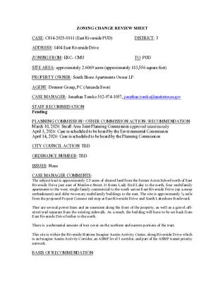
ZONING CHANGE REVIEW SHEET CASE: C814-2025-0111 (East Riverside PUD) DISTRICT: 3 ADDRESS: 1404 East Riverside Drive ZONING FROM: ERC- CMU TO: PUD SITE AREA: approximately 2.6069 acres (approximately 113,556 square feet) PROPERTY OWNER: South Shore Apartments Owner LP AGENT: Drenner Group, PC (Amanda Swor) CASE MANAGER: Jonathan Tomko 512-974-1057, jonathan.tomko@austintexas.gov STAFF RECOMMEDATION: Pending PLANNING COMMISSION / OTHER COMMISSION ACTION / RECOMMENDATION: March 10, 2026: Small Area Joint Planning Commission approved unanimously April 1, 2026: Case is scheduled to be heard by the Environmental Commission April 14, 2026: Case is scheduled to be heard by the Planning Commission CITY COUNCIL ACTION: TBD ORDINANCE NUMBER: TBD ISSUES: None CASE MANAGER COMMENTS: The subject tract is approximately 2.5 acres of cleared land from the former Acton School north of East Riverside Drive just east of Manlove Street. It fronts Lady Bird Lake to the north, four multifamily apartments to the west, single family commercial to the south across East Riverside Drive (up a steep embankment) and older two-story multifamily buildings to the east. The site is approximately ¼ mile from the proposed Project Connect rail stop at East Riverside Drive and South Lakeshore Boulevard. Ther are several power lines and an easement along the front of the property, as well as a gravel off- street trail separate from the existing sidewalk. As a result, the building will have to be set back from East Riverside Drive further to the north. There is a substantial amount of tree cover on the northern and eastern portions of the tract. This site is within the Riverside Stations Imagine Austin Activity Center, along Riverside Drive which is an Imagine Austin Activity Corridor, an ASMP level 3 corridor, and part of the ASMP transit priority network. BASIS OF RECOMMENDATION: Site North (across Lady Bird Lake) South (across East Riverside Drive) East C814-2025-0111 TBD EXISTING ZONING AND LAND USES: 2 LAND USES ZONING ERC-CMU Undeveloped land P-NP Undeveloped parkland/trail ERC-NMU Office/retail in a two-story single family constructed in approximately 1951 ERC-CMU Several multifamily apartment buildings of 2 stories constructed in approximately 1963 West ERC-CMU Four apartment buildings were constructed in approximately 2012. The buildings are approximately 11, 9, 6, and 4 stories each. NEIGHBORHOOD PLANNING AREA: East Riverside/Oltorf (Riverside) Combined Neighborhood Planning Area WATERSHED: Lady Bird Lake and Harpers Branch Watersheds SCHOOLS: A.I.S.D. Sanchez Elementary School Martin Middle School Austin High School COMMUNITY REGISTRY LIST: Austin Independent School District, Austin Neighborhoods Council, Crossing Gardenhome Owners Association, Del Valle Community Coalition, East Austin Conservancy, East Riverside/Oltorf Neighborhood Plan Contact Team, Friends of Austin Neighborhoods, Homeless Neighborhood Assciation, Overton Family Committee, Pleasant Valley, Preservation Austin, South Central Coalition, Southeast Austin Neighborhood Alliance, South River City Citizens Association, Zoning Committee of South River City Citizens AREA CASE HISTORIES: Number C14-2024-0147 (1405 East Riverside Drive) C814-2008-0087.02 (South Shore PUD Addition) Request To rezone from ERC-NMU to ERC- CMU and to allow a maximum height of 120’ with a voluntary density bonus To rezone from ERC-CMU to PUD to allow a maximum height of 180’ with a Commission 03.25.2025: Case indefinitely postponed City Council N/A TBD 03.10.2026: Applicant postponement to 03.24.2026 C814-2025-0111 3 voluntary density bonus RELATED CASES: C20-2026-001: Code Amendment associated with removal of this site from the ERC. DA-2022-1048: Development Assessment Issued 12.01.2022 ADDITIONAL STAFF COMMENTS: Arborist CA1/CA2 compliance compliance with (2.4 requirements. Provide the following information to (mathematically) demonstrate Tier 2 related to trees. The previous response indicated only partial Tier II Requirements, 2 Environmental, m.) preservation Heritage (100%) Tree number Inches Preserved Inches Removed Trees DDI/Dead (Provide report) Total inches preserved Total inches existing Percentage preserved Preserves all heritage trees; x Tree number Inches Preserved Inches Removed DDI/Dead (Provide report) Total inches preserved Total inches existing Percentage preserved x Native Protected Size Trees preserves 75% of the caliper inches Associated with native protected size trees Tree number Inches Preserved Inches Removed DDI/Dead (Provide report) Total inches preserved Total inches existing Percentage preserved Native Caliper Inches x preserves 75% of all of the native caliper inches C814-2025-0111 4 CA3 An administrative variance memo is required to request removal of trees # 15268 and 15269. Provide a variance memo addressed to the City Arborist to Heritage include the following: 1. Tree number, species, location graphic, and DBH of Heritage tree(s) proposed for removal. 2. Applicant findings per the LDC 25-8-642. 3. If removal is sought based on condition, a third party arborist assessment is required. The assessment must have the following information in PDF format (photo links are not accepted): a. The tree number, size, and species of tree(s). b. Photos of the tree(s) including: i. tree number; ii. entire tree from root to top of crown; iii. thorough description of defects and/or disease with associated photo(s). iv. 3D Tomographic Scan results v. Any and all additional information related to the condition of the trees to warrant removal due to condition. Austin Energy Prior to construction please contact AE customer service for disconnection of electrical services at 512-494-9400 Please review and follow Section 1.10.2 Minimum Working Clearances from Energized Overhead Electric Utility Lines – Austin Energy Design criteria for working clearance as there is overhead facilities within the vicinity of the site. Drainage Engineering DE 1. Land Use Plan Notes #8 states “a waiver to DCM 4.1.0A is approved to allow an alternative type inlet, such inlet shall be approved by the Director of Watershed Protection Department and the Department of Public Works”. Please remove. DCM Waivers are available to all projects and is not a variation from Code or Criteria. This item is also not noted in the Modification Chart. Update 1: Comment cleared. Applicant response states that this waiver will be pursued at the time of site development. Please note that it will be reviewed at that time. DE 2. At this time the reviewer does not see any modifications to LDC 7 Drainage. Please confirm. Update 1: Comment cleared. Response states that no deviation from 25-7 is being requested. Environmental EO1. Remove references to functional green rating. This system is not being adopted by the city. However, the inclusion of an extensive green roof installation with pollinator plantings may count towards the project’s superiority. Update 1. Comment cleared C814-2025-0111 5 EO2. The application indicates that 10% of the roof terrace will be green roof. Provide additional information about the size of this space. Update 1. Comment pending. The applicant indicates the size of the green roof media space is estimated to be no smaller than 750 square feet, or approximately 10% of the total rooftop/courtyard area, and 100% of the green roof planter system is proposed to be extensive vegetated green roof media or greater. This language should be added to the PUD notes. EO3. Provide an environmental exhibit showing areas of restoration, native plant lists, and (conceptual designs are acceptable and other environmental enhancements encouraged). Update 1. The environmental exhibit shows both the required CEF mitigation and proposed superiority. However, it is unclear what enhancements are proposed as superior. Please clarify in this exhibit or provide a separate exhibit for the specific superior environmental enhancements. EO4. Pervious fire lanes are not recommended by staff. Long term use of pervious fire lanes results in compaction that prevents stormwater infiltration. Update 1. The fire lane should be treated as impervious and the proposed increase in IC should accommodate for the fire lane. EO5 Remove the requirement for non-toxic trees. There are several desirable native drought resistant trees that are considered toxic. Update 1. Comment cleared EO6 Provide more information on the landscape irrigation requirements for the site and how much condensate will be used for irrigation. Update 1. Comment cleared. The applicant has indicated that condensate collected from the air conditioning units will support 100% of ground level irrigation. Fire No comments on rezoning Housing H1. Project is approved with the following conditions: The baseline to establish a development bonus is CS zoning district with a maximum height of 180 feet and a maximum Floor to Area Ratio (FAR) of 4:1. The development will include 8,216 square feet (approximately 15-units) of on-site housing, reflecting previously-approved bonus area of 65,730 square feet. The development will satisfy additional affordable housing requirements through payment of a fee-in-lieu equal to $1.50 per square foot of bonus area achieved. Include the following requirements as notes in the site plan sheets: C814-2025-0111 6 1. The PUD Shall Comply With Section 2.5.2.B.2, Requirements For Exceeding Baseline, of the PUD regulations by providing a fee in the amount established under Section 2.5.6 (In Lieu Donation) for each square foot of bonus square footage above the baseline FAR to the Affordable Housing Trust Fund to be used for producing or financing affordable housing, as determined by the Director of Austin Housing for bonus square footage. Onsite units provided shall be credited for bonus area as prescribed in Section 2.5.3. 2. A minimum of 8,216 sf of affordable housing shall be provided on site (approx. 15 units). Such square footage shall be credited to the fee in lieu requirements outlined in Affordable Housing Note 2. 3. Any onsite affordable housing provided shall comply with the following: a) Units shall be affordable for a period of forty (40) years following the last Certificate of Occupancy for each phase of the development. b) Affordable units must be available for occupancy concurrently with the market-rate units. c) Affordable units may be rotated within the structure, provided that the total number of required affordable units/square footage remains in compliance. d) Project shall prepare and follow an affirmative marketing and outreach plan for the duration of the forty (40) year period, in a form consistent with the U.S. Department of Housing and Urban Development regulations and approved by the Austin Housing director. e) Owner shall not lease an affordable unit for more than the maximum affordable price. Hydro Geologist HG1_U0 There are existing hydrogeologic Critical Environmental Features (CEFs) on the property. The approved site development permit (SP-2021-0451C) includes a CEF Mitigation Plan which will be maintained as part of the PUD. Mitigation measures include invasive species removal and appropriate plantings. To receive credit for superiority, additional mitigation or restoration will need to be provided above the CEF mitigation already required by code. Alternative mitigation strategies will be considered by this reviewer. Update 1: Comment cleared - Applicant plans to proceed with initially approved mitigation plan as part of SP-2021-0451C. No additional impacts to established setback are proposed, and ENV superiority through CEF mitigation no longer being pursued. HG2_U0 Please provide an exhibit which includes all environmental enhancements or environmental superiority efforts including restoration to the CWQZ, enhanced stabilization at the stormwater outfall(s) and any other environmental enhancements. Update 1: Comment cleared - Applicant plans to proceed with initially approved mitigation plan as part of SP-2021-0451C. No additional impacts to established setback are proposed, and ENV superiority through CEF mitigation no longer being pursued. PARD – Planning & Design Review C814-2025-0111 7 PR 1. There is an approved site plan on this lot (SP-2021-0451C – Acton School Redevelopment). This site plan required parkland dedication for 222 units, including 15 certified affordable units. Parkland dedication was required in the form of a park easement and park improvements. The park easement has been recorded and is shown within the orange outline below. Fiscal surety was posted for the park improvements consisting of a dog park and associated amenities including seating and lighting, which will be built within the blue outline area. The park area along the back / north of the property will be undeveloped, but accessible to the public for passive recreation, e.g. overlooking Lady Bird Lake. All of these items were planned with the original site plan, and the applicant has confirmed that none of these items are proposed to change. U1: Thank you for your response. Comment cleared. PR 2. For the proposed PUD, parkland superiority is not proposed. Rather, the PUD would be silent on parkland. Parkland dedication associated with the previous site plan followed current code, and was not considered superior. Any future site plans, revisions, or corrections would be reviewed under current or applicable code sections. U1: Thank you for your response. Comment cleared. PR 3. The applicant met with Austin Parks and Recreation (APR) on 12/10/25 and went over proposed changes to the site plan. We considered potential impacts to parkland, and found that the parkland would not be impacted by these changes. Based on the plan that we previewed, any additional proposed units, beyond the 222 already permitted, would owe fees in lieu of parkland. If the plan changes substantially or a completely new site C814-2025-0111 8 plan is submitted, APR will re-review and make a new assessment of parkland requirements. U1: Thank you for your response. Comment cleared. Site Plan Site Plan Comments addressed Transportation and Public Works (TPW) Department – Engineering Review TPW 1. The Austin Strategic Mobility Plan (ASMP) calls for 141 feet of right-of-way for E. Riverside Drive. It is recommended that 70.5 feet of right-of-way from the existing centerline should be dedicated for E. Riverside Drive according to the Transportation Plan with the first subdivision or site plan application. [LDC 25-6-51 and 25-6-55]. TPW 2. The Austin Strategic Mobility Plan (ASMP) calls for 58 feet of right-of-way for Manlove Street. It is recommended that 29 feet of right-of-way from the existing centerline should be dedicated for Manlove Street according to the Transportation Plan with the first subdivision or site plan application. [LDC 25-6-51 and 25-6-55]. EXISTING STREET CHARACTERISTICS: Name ASMP Classifi cation ASMP Required ROW Existing ROW Existing Pavement Sidewalks Bicycle Route Capital Metro (within ¼ mile) E. Riverside Drive Level 3 141’ 134’ 98’ Yes Yes Yes Manlove Street Level 1 58’ 50’ 24’ Yes No Yes TIA: A traffic impact analysis is NOT required. Traffic generated by the proposal does not exceed the thresholds established in the City of Austin Land Development Code (LDC). Mitigation per LDC 25-6-101 may still apply. Wetlands Biologist Review WB1. Update 0. An Integrated Pest Management Plan is to be approved by the Director of Austin Watershed Protection at the time of site plan approval. The plan should establish baseline maintenance practices to support a healthy riparian habitat including but not limited to the management of invasive species, establishment and monitoring of native plant community, and activities to support the health of canopy and understory trees. U1. Comment cleared. Applicant commented that an Integrated Pest Management Plan (IPM) was initially prepared per document no. 2011103979 and amended with the current site plan SP-2021-0451C and recorded as document no. 2023124418. Additional amendments, if necessary, to the existing IPM will be completed at the time of site plan amendment following PUD approval. C814-2025-0111 9 WB2. Update 0. Plant selection for GSI storm water controls must utilize plants native to the Central Texas Blackland Prairie and Edwards Plateau ecoregions and be approved by a WPD wetland biologist. For GSI quality controls, provide standards on plant diversity and species composition (e.g. minimum of 3 natives herbaceous species, all plants native to eco region, etc.) U1. Comment partially addressed. Please replace Buddleja marrubiifolia (likes very dry conditions) and Galphimia glauca (non-native) with Rudbeckia hirta or Rudbeckia maxima and Chasmanthium latifolium in your Biofiltration/Sedimentation Plant List. WB3. Update 0. Provide standards on plant diversity and species composition (e.g. minimum of 3 native herbaceous species, all plantings native to eco region, etc.) for the planting specifications within the landscape areas and designated restoration areas. Include pollinator and wildlife friendly plant species. U1. Comment partially addressed. Please replace Buddleja marrubiifolia (likes very dry conditions) and Galphimia glauca (non-native) with Rudbeckia hirta or Rudbeckia maxima and Chasmanthium latifolium in your Biofiltration/Sedimentation Plant List. Buddleja marrubiifolia can be utilized in the landscape, but will not perform well in rain gardens, water quality ponds, at outfalls, or in areas used for treating stormwater. WB4. Update 0. There are existing Critical Environmental Features (CEFs) on the property. The approved site development permit (SP-2021-0451C) includes a Wetland Mitigation Plan which will be maintained as part of the PUD. Mitigation measures include invasive species removal and appropriate plantings. Mitigation for reduction of the wetland setback should be accounted for in the PUD ordinance and shown in an exhibit that should be superior to the Wetland Mitigation Plan in SP-2021-0451C. To receive credit for superiority, additional mitigation or restoration will need to be provided above the wetland mitigation already required by code. Alternative mitigation strategies will be considered by this reviewer. U1. Comment cleared. Met with applicant on 1/30/2026 to discuss environmental superiority aspects of the PUD and wetland mitigation as well as CWQZ restoration. They applicant stated they are not going for environmental superiority with the CEF mitigation plan and will use the approved mitigation plan from SP-2021-0451C. WB5. Update 0. Please provide an exhibit which includes all environmental enhancements or environmental superiority efforts including restoration to the CWQZ, enhanced stabilization at the stormwater outfall(s) and any other environmental enhancements in addition to the wetland mitigation. U1. Comment partially addressed. It is not clear to this reviewer what are the elements of environmental superiority. Please, distinguish between the minimum required mitigation and enhancements to be applied to the projects environmental superiority efforts. Water Quality Release of this application does not constitute a verification of all data, information, and calculations supplied by the applicant. The engineer of record is solely responsible for the C814-2025-0111 10 completeness, accuracy, and adequacy of his/her submittal, whether or not the application is reviewed for code compliance by city engineers. WQ FYI: The application states that “Does not request exceptions to or modifications of environmental regulations”. No comments at this time. Austin Water Utility No comments on rezoning INDEX OF EXHIBITS AND ATTACHMENTS TO FOLLOW: A. Zoning Map B. Aerial Map C. Applicant’s Summary Letter D. Land Use Plan E. Superiority Chart F. PUD Code Modifications Table 03.06.2026 G. Environmental Superiority Exhibit !!!!!!!!!!!!!!!!!!!!!!!!!!!!!!!!!!!!!!!!!!!!!!!!!!!!!!!!!!!!!!!!!!!!!!!!!!!!!!!!!!!!!!!!!!!!!!!!!!!!!!!!!!!!!!!!!!!!!!!!!!!!!!!!!!!!!!!!!!!!!!!!!!!!!!!!!!!!!!!!!!!!!!!!!!!!!!!!!!!!!!!!!!!!!!!!!!!!!!!!!!!!!!!!!!!!!!!!!!!(!(!(!(!(!(!(!(!(!(!(!(!(!(!(!(!(!(!(!(!(!(!(!(!(!(!(!(!(!(!(!(!(!(!(!(!(!(!(!(!(!(!(!(!(!(!(!(!(!(!(!(!(!(!(!(!(!(!(!(!(!(!(!(!(!(!(!(!(!(!(!(!(!(!(!(!(!(!(!(!(!(!(!(!(!(!(!(!(!(!(!(!(!(!(!(!(!(!(!(!(!(!(!(!(!(!(!(!(!(!(!(!(!(!(!(!(!(!(!(!(!(!(!(!(!(!(!(!(!(!(!(!(!(!(!(!(!(!(!(!(!(!(!(!(!(!(!(!(!(!(!(!(!(!(!(!(!(!(!(!(!(!(!(!(!(!(!(!(!(!(!(!(!(!(!(!(!(!(!(!(!(C814-2025-0111C14-05-0112C14-00-2102C14-05-0139C14-2012-0111NPA-2011-0021.02NPA-2012-0021.02C14-05-0112(RCA)C14-05-0112(RCA2)NP-01-0010C14-01-0166C14-2015-0055C14-2019-0072NPA-2015-0002.01C814-2008-0087C14H-97-0008C14-2021-0029C14-04-0030C14-06-0117C14-01-0002C14-06-0053C14-01-0001C14-05-0067C14-2007-0224C14H-97-0009C14-04-0136C14H-2015-0147C14-2020-0081NPA-2020-0021.02C14-05-0112.01S IH 35 SBS IH 35 NBS IH 35 SVRD SBS IH 35 SVRD NBSUMMIT STLUPINE LNNASH HERNANDEZ SR RDEAST AVEN IH 35 SBN IH 35 NBART DILLY DRCOMAL STREAGAN TERE RIVERSIDE DRBONHAM TERSUNNY VALE STN IH 35 SVRD NBKENWOOD AVEUPLAND DRN IH 35 SVRD SBCHICON STLOMA DROLD EAST RIVERSIDE DRRIVERVIEW STBETTY JO DRSALINA STSOUTH LAKESHORE BLVDINGLEWOOD STSHORE DISTRICT DRMANLOVE STHARWOOD PLPARKER LNCHALMERS AVECHELSEA LNWALLER STE RIVERSIDE WB TO 35 NB RAMPS IH 35 SB TO REAGAN RAMPS IH 35 NB TO E RIVERSIDE RAMPPARKINSON DRMANLOVE STERCP-NPP-NPP-NPPSF-3-NPSF-3-NPERCP-NPP-NPERCERCERCSF-3-NPSF-3-NPERCSF-3-NPPUD-NPSF-3-NPCS-MU-V-CO-NPGO-CO-ETOD-DBETOD-NPERCSF-3-NPSF-3-NPMF-4SF-3-NPSF-3-NPPUDERCSF-3-NPMF-2SF-3-NPSF-3-NPSF-3-NPSF-3-NPP-NPSF-3-NPP-NPSF-3-NPSF-3-NPSF-3-NPPMF-4-NPPUDP-H-NPPSF-3-NPGR-MU-COGO-CO-ETOD-DBETOD-NPCBDSF-3-NPLR-NPLR-MU-CO-NPSF-3-NPSF-3-NPGO-ETOD-DBETOD-NPNO-ETOD-DBETOD-NPLO-CO-NPERCSF-3-NPSF-3-NPNO-MU-NPGR-MU-CO-NPMF-4-NPSF-3-NP1404 East Riverside PUD±This product has been produced by Austin Planning for the sole purpose of geographic reference. No warranty is madeby the City of Austin regarding specific accuracy or completeness.ZONING CASE#:LOCATION:SUBJECT AREA:MANAGER:C814-2025-01111400 1/2, 1404, 1404 1/2,1408 E Riverside Dr2.62 AcresJonathan TomkoCreated: 1/13/2026SUBJECT TRACTZONING BOUNDARY!!!!!PENDING CASECREEK BUFFER1 inch equals 400 ' Amanda Swor direct dial: (512) 807-2904 aswor@drennergroup.com November 10, 2025 Ms. Lauren Middleton-Pratt Austin Planning Department 6310 Wilhelmina Delco Dr. Austin, TX 78752 Via Electronic Delivery Re: 1404 East Riverside PUD and NPA – Planned Unit Development (“PUD”) and Neighborhood Plan Amendment (“NPA”) applications for the 2.6-acre piece of property located at 1400 ½, 1404, 1404 ½ and 1408 East Riverside Drive, Austin, Travis County, Texas (the “Property”) Dear Ms. Middleton-Pratt: As representatives of the owner of the Property, we respectfully submit the enclosed PUD zoning application and NPA application packages. The project is titled 1404 East Riverside PUD, consists of 2.62 acres, and is located at 1400 ½, 1404, 1404 ½ and 1408 East Riverside Drive, approximately 500 feet east of the intersection of East Riverside Drive and the IH-35 frontage road. The Property also has frontage on Manlove Street. The Property is currently undeveloped and was previously the site of the Acton Business School. The Property is currently zoned ERC, East Riverside Corridor, and is more specifically located in the Corridor Mixed Use (“CMU”) subdistrict. The requested rezoning is from ERC to PUD, Planned Unit Development. A development assessment application for the project was submitted on June 30, 2025 per City of Austin case number CD-2025-0002. Additionally as part of this zoning application, a code amendment will be initiated to remove the Property from the ERC Regulating Plan. The Property is located in the East Riverside/Oltorf Combined Neighborhood Plan and is currently designated as “Specific Regulating District” on the Future Land Use Map (“FLUM”). The Property is proposed to be amended from “Specific Regulating District” to “Multifamily” on the FLUM. The purpose of the NPA is to align the FLUM designation on the Property with the proposed zoning designation and with the removal of the site from the area governed by the ERC Regulating Plan. The proposed project will include an amendment to the approved Acton School Redevelopment site plan, City of Austin case number SP-2021-0451C. The approved site plan permits 222 multifamily units. The proposed PUD will contain approximately 381 multifamily residential units, inclusive of the 15 on-site affordable housing units. The project will comply with the PUD ordinance for any additional affordable housing requirements. Approximately 44% of the site area, or 1.17 acres, was dedicated as parkland to the City of Austin per the approved site plan, as well as a fiscal payment of $108,983.43 for park improvements as well as $504,373.99 paid for additional fee-in-lieu. The Property is located in the East Riverside District of the Waterfront Overlay and will substantially comply with the Waterfront Overlay regulations; the modifications proposed are minor in nature and will not impact the superior project developed in close proximity to Lady Bird Lake. The PUD proposes to utilize the CS base district as the baseline for the PUD. As described in the attached superiority chart, the proposed PUD meets or exceeds all applicable Tier I and Tier II requirements as defined in the Land Development Code, thus resulting in a superior development that could not be achieved with conventional zoning. A Traffic Impact Analysis (TIA) will not be required as indicated in the attached TIA Determination Form executed by Nazlie Saeedi, dated June 26, 2025. Please let me know if you or your team members require additional information or have any questions. Thank you for your time and attention to this project. Very truly yours, Amanda Swor cc: Joi Harden, Austin Planning Department (via electronic delivery) Nancy Estrada, Austin Planning Department (via electronic delivery) Matthew Bunch, Mill Creek Residential (via electronic delivery) Jeb Cox, Mill Creek Residential (via electronic delivery) Dwayne Shoppa, Kimley-Horn (via electronic delivery) Sam Pheiffer, Kimley-Horn (via electronic delivery) Denny Simon, Ziegler Cooper (via electronic delivery) Axel Weisheit, Ziegler Cooper (via electronic delivery) Bobak Tehrany, BOE (via electronic delivery) Saba Hatami, BOE (via electronic delivery) Wesley Salazar, KW (via electronic delivery) Clifford Schaefer, KW (via electronic delivery) -2- NORTH LEGEND PROPERTY LINE LIMITS OF CONSTRUCTION EXISTING OVERHEAD POWER LINE EXISTING WATER LINE EXISTING SANITARY SEWER LINE EXISTING STORM SEWER LINE EXISTING POWER POLE EXISTING FIRE HYDRANT EXISTING WATER METER EXISTING SANITARY SEWER MANHOLE EXISTING TREE TO BE REMOVED EXISTING TREE TO REMAIN EXISTING HERITAGE TREE TO REMAIN DEMOLITION OF PAVEMENT, CURB AND GUTTER, STRUCTURES, AND OTHER MISCELLANEOUS INFRASTRUCTURE ON-SITE WETLANDS LAND USE SUMMARY TABLE USE AREA MULTIFAMILY 426,998 GSF UNITS 381 FOR REVIEW ONLY Not for construction or permit purposes. Engineer P.E. No. SAMUEL T. PHEIFFER 131983 3/12/2026 Date E V O L N A M T E E R T S E. RIVERSIDE DR. NOTES: 1. 2. 3. SURVEY PERFORMED BY STANTEC CONSULTING SERVICES, INC. ON 7/7/2021. TBPELS 10194230 TREE ASSESSMENT PERFORMED BY TREE MANN SOLUTIONS ON MAY 27, 2021 ADDITIONAL TREE ASSESSMENT PERFORMED BY MICHAEL EMBESI OF BARTLETT TREE EXPERTS. REFERENCE REPORTS DATED 5/22/2024 AND 5/13/2024. SUBMITTAL DATE: 11/6/2025 ACREAGE: 2.62 AC LEGAL DESCRIPTION: TRACT 1: ALL OF THAT CERTAIN TRACT OR PARCEL OF LAND BEING LOT A, PHIL MILLER ADDITION, A SUBDIVISION IN THE CITY OF AUSTIN, TRAVIS COUNTY, TEXAS AS RECORDED IN VOLUME 67, PAGE 97 OF THE PLAT RECORDS OF TRAVIS COUNTY, TEXAS INCLUDING THAT PORTION OF EDGECLIFF STREET AS VACATED BY THE CITY OF AUSTIN BY ORDINANCE NO. 2004168038 OF THE OFFICIAL PUBLIC RECORDS OF TRAVIS COUNTY, TEXAS. TRACT 2: ALL OF THAT CERTAIN TRACT OR PARCEL OF LAND BEING A PORTION OF LOTS 24, 25, 26, AND 27 OF THE SUBDIVISION OF LOTS 2, 3, 4, AND PART OF 5, COLORADO RIVER PARK ADDITION, A SUBDIVISION IN THE CITY OF AUSTIN, TRAVIS COUNTY, TEXAS AS RECORED IN VOLUME 3, PAGE 98 OF THE PLAT RECORDS OF TRAVIS COUNTY, TEXAS BEING THAT SAME 0.659 ACRE TRACT OF LAND AS CONVEYED TO LAKE RIVERSIDE INVESTMENTS, LP BY INSTRUMENT RECORDED IN DOCUMENT NO. 2006008633 OF THE OFFICIAL PUBLIC RECORDS OF TRAVIS COUNTY, TEXAS. TRACT 3: ALL OF THAT CERTAIN TRACT OR PARCEL OF LAND OUT OF THE SANTIAGO DEL VALLE GRANT IN THE CITY OF AUSTIN, TRAVIS COUNTY, TEXAS, BEING THAT CERTAIN VACATED PORTION OF EDGECLIFF STREET CONVEYED TO ACTON BUSINESS SCHOOL BY INSTRUMENT RECORDED IN DOCUMENT NO. 2006008632 OF THE OFFICIAL PUBLIC RECORDS OF TRAVIS COUNTY, TEXAS. TRACT 4: ALL OF THAT CERTAIN TRACT OR PARCEL OF LAND BEING A PORTION OF LOT 1 AND ALL OF LOTS 2, 3, 4, AND 5 OF THE SUBDIVISION OF LOTS 2, 3, 4, AND PART OF 5, COLORADO RIVER PARK ADDITION, A SUBDIVISION IN THE CITY OF AUSTIN, TRAVIS COUNTY, TEXAS AS RECORDED IN VOLUME 3, PAGE 98 OF THE PLAT RECORDS OF TRAVIS COUNTY, TEXAS, THE HEREIN DESCRIVED TRACT BEING THAT SAME 1.1314 ACRE TRACT OF LAND CONVEYED TO ACTON BUSINESS SCHOOL BY INSTRUMENT RECORDED IN DOCUMENT NO. 2006008632 OF THE OFFICIAL PUBLIC RECORDS OF TRAVIS COUNTY, TEXAS. FLOODPLAIN INFORMATION: A PORTION OF THIS SITE IS LOCATED WITHIN THE 100-YEAR FLOODPLAIN. FIRM PANEL NO. 48453C0605K, TRAVIS COUNTY, TEXAS AND INCORPORATED AREAS (EFFECTIVE DATE JANUARY 22, 2020). NOTES: 1. PUD BASELINE ZONING IS CS, GENERAL COMMERCIAL SERVICES. N A L P E S U D N A L T S A E 4 0 4 1 D U P E D S R E V R I I I R D E D S R E V R I . E 4 0 4 1 I N T S U A F O Y T C I S A X E T , Y T N U O C S V A R T I 1 OF 4 LAND USE PLAN NOTES ENVIRONMENTAL: BUILDING DESIGN: SITE DEVELOPMENT REGULATIONS AND CODE MODIFICATIONS: THE PUD IS SUBJECT TO THE SITE DEVELOPMENT REGULATIONS ASSOCIATED WITH THE CS ZONING BASE DISTRICT, EXCEPT AS MODIFIED ON THE LAND USE PLAN AND ASSOCIATED NOTES. THE CS ZONING BASE DISTRICT REGULATIONS SHALL BE ESTABLISHED AS THE BASELINE FOR DETERMINING DEVELOPMENT BONUS UNDER SECTION 25-2, SUBCHAPTER B, DIVISION 5, 1.4.1.C. 1. 2. 1. 2. 3. THE MAXIMUM HEIGHT FOR THE PUD MAY NOT EXCEED 180 FEET. SECTION 25-2-531, HEIGHT LIMIT EXCEPTIONS, STILL APPLY TO THE PUD. THIS 180-FOOT MAXIMUM HEIGHT SHALL BE ESTABLISHED AS A DEVELOPMENT BONUS UNDER SECTION 25-2, SUBCHAPTER B, DIVISION 5, 1.4.1.D. THE MAXIMUM FLOOR TO AREA RATIO (FAR) IN THE PUD IS 4:1. THIS 4:1 FAR SHALL BE ESTABLISHED AS A DEVELOPMENT BONUS UNDER SECTION 25-2-, SUBCHAPTER B, DIVISION 5, 1.4.1.D. 4. PERMITTED, CONDITIONAL AND PROHIBITED LAND USES SHALL BE CONSISTENT WITH THE CS BASE DISTRICT WITH THE FOLLOWING MODIFICATIONS: MULTIFAMILY RESIDENTIAL BED AND BREAKFAST RESIDENTIAL a. THE FOLLOWING ARE ADDITIONAL PERMITTED USES IN THE PUD: i. ii. MAJOR UTILITY FACILITY b. THE FOLLOWING ARE PROHIBITED USES IN THE PUD: i. ii. HOSPITAL SERVICES iii. iv. v. vi. vii. viii. ix. x. xi. xii. xiii. xiv. xv. xvi. xvii. xviii. xix. xx. xxi. xxii. xxiii. xxiv. PRINTING AND PUBLISHING SERVICES xxv. SERVICE STATION xxvi. VEHICULAR STORAGE xxvii. VETERINARY SERVICES xxviii. CUSTOM MANUFACTURING xxix. LIMITED WAREHOUSING AND DISTRIBUTION ADULT-ORIENTED BUSINESSES AUTOMOTIVE RENTALS AUTOMOTIVE REPAIR SERVICES AUTOMOTIVE SALES AUTOMOTIVE WASHING BAIL BOND SERVICES BUSINESS OR TRADE SCHOOL CAMPGROUND COMMERCIAL BLOOD PLASMA CENTER CONSTRUCTION SALES AND SERVICES CONVENIENCE STORAGE DROP-OFF RECYCLING COLLECTION FACILITY ELECTRONIC TESTING EQUIPMENT REPAIR SERVICES EQUIPMENT SALES EXTERMINATION SERVICES FUNERAL SERVICES KENNELS LAUNDRY SERVICES MONUMENT RETAIL SALES PLANT NURSERY AN INTEGRATED PEST MANAGEMENT PROGRAM THAT COMPLIES WITH SECTION 1.6.9.2(D) (PESTICIDES AND HERBICIDES) OF THE ECM, IS APPROVED ON THE SITE AND WILL BE IMPLEMENTED WITH PROJECT DEVELOPMENT. THE PROJECT SHALL ACHIEVE A THREE-STAR OR GREATER RATING UNDER THE AUSTIN ENERGY GREEN BUILDING PROGRAM USING THE APPLICABLE RATING VERSION IN EFFECT AT THE TIME A RATING REGISTRATION APPLICATION IS SUBMITTED FOR THE BUILDING. 3. 100% OF THE REQUIRED SITE STORMWATER SHALL BE TREATED USING WATER QUALITY METHODS ON SITE. 4. AS A SUPERIORITY ITEM, THE PROJECT SHALL CAPTURE AND TREAT OFF-SITE STORMWATER FROM APPROXIMATELY 7,000 SQUARE FEET OF MANLOVE STREET THAT IS CURRENTLY UNTREATED. SUCH WATER SHALL BE TREATED WITH INNOVATIVE WATER QUALITY CONTROLS SUCH AS A JELLYFISH. THIS TREATMENT AREA IS IN ADDITION TO THE PROPERTY'S REQUIRED TREATMENT AREA AND SHALL BE PRIVATELY MAINTAINED. 5. ALL REQUIRED TREE PLANTINGS SHALL USE: a. NATIVE TREE SPECIES SELECTED FROM APPENDIX F (DESCRIPTIVE CATEGORIES OF TREE SPECIES) OF THE ENVIRONMENTAL CRITERIAL MANUAL; AND b. CENTRAL TEXAS NATIVE SEED STOCK AS APPROVED BY THE DIRECTOR OF DEVELOPMENT SERVICES DEPARTMENT. c. NO SINGLE SPECIES SHALL COMPRISE MORE THAN 15% OF THE OVERALL MITIGATION TO ENSURE BIODIVERSITY. 100% OF ALL NON-TURF PLANT MATERIALS SHALL BE SELECTED FROM THE ENVIRONMENTAL CRITERIA MANUAL APPENDIX N (CITY OF AUSTIN PREFERRED PLANT LIST) OF THE “GROW GREEN NATIVE AND ADAPTIVE LANDSCAPE PLANTS GUIDE" WHICH ARE NATIVE TO THE EDWARDS PLATEAU AND BLACKLAND PRAIRIE ECOREGIONS AND ARE MEDIUM- TO LOW-WATER USAGE. THE PROJECT SHALL INSTALL RAISED TERRACE GREEN ROOF MEDIA PLANTED WITH A FOCUS ON POLLINATOR FRIENDLY SPECIES. THE SIZE OF GREEN ROOF MEDIA SPACE SHALL BE A MINIMUM OF 750 SQUARE FEET OF THE TOTAL ROOFTOP/COURTYARD AREAS. 100% OF THIS GREEN ROOF PLANTER SYSTEM SHALL BE EXTENSIVE GREEN ROOF MEDIA OR GREATER. THE PROJECT SHALL PROVIDE A MINIMUM OF 30% LANDSCAPED AREA WITHIN THE REQUIRED STREETYARDS. THE PROJECT SHALL MEET OR EXCEED THE LANDSCAPE REQUIREMENTS OF SUBCHAPTER E BY PROVIDING A DIVERSE MIXTURE OF LANDSCAPING AND UTILIZING DROUGHT-RESISTANT PLANTS. 6. 7. 8. 9. 10. THE PROJECT SHALL COLLECT CONDENSATE FROM AIR CONDITIONING UNITS TO SUPPORT 100% OF GROUND LEVEL IRRIGATION. 11. THE PROJECT SHALL BE COMPLIANT WITH THE LEED PILOT BIRD COLLISION DETERRENCE CREDIT IN REGARD TO THE BIRD COLLISION THREAT RATING FOR REFLECTIVE GLASS WITHIN THE FAÇADE ZONE 1 AREA AS DEFINED BY LEED. 5. SECTION 25-2-734(C), (EAST RIVERSIDE SUBDISTRICT REGULATIONS) IS AMENDED TO 12. THE PROJECT SHALL COMPLY WITH DARK SKY REGULATIONS FOR ALL EXTERIOR ALLOW A MAXIMUM IMPERVIOUS COVER OF 70%. LIGHTING AND WILL NOT UP-LIGHT THE FAÇADE. 6. SECTION 25-2-734 (D), (EAST RIVERSIDE SUBDISTRICT REGULATIONS) IS AMENDED TO ALLOW A MAXIMUM HEIGHT OF 180 FEET. 7. A WAIVER FROM TCM 9.4.1.D IS APPROVED TO ALLOW FOR MANEUVERING IN MANLOVE STREET RIGHT-OF-WAY TO SERVE AN ON-SITE LOADING ZONE AND SEPARATE TRASH/RECYCLE COLLECTION FACILITY. NOTE: SUCH WAIVER WAS GRANTED WITH THE CURRENTLY APPROVED SITE DEVELOPMENT PERMIT ON THE PROPERTY; ANY DEVIATIONS FROM THE APPROVED SITE PLAN MAY REQUIRE ADDITIONAL REVIEW AND MAY BE REQUIRED TO CONFORM TO CURRENT CODE/CRITERIA. 8. NOTE INTENTIONALLY DELETED. 9. A WAIVER TO TCM TABLE 7-2 IS APPROVED TO ALLOW AN APPROXIMATELY 58-FOOT WIDE DRIVEWAY IN ORDER TO ACCOMMODATE TENANT INGRESS AND EGRESS, LOADING AND TRASH/RECYCLE COLLECTION IN SEPARATE FACILITIES. THIS APPROVED DRIVEWAY SHALL BE IN ACCORDANCE WITH SHEET 4 OF THIS LAND USE PLAN. ANY DEVIATION FROM SHEET 4 OF THE PUD LAND USE PLAN MAY REQUIRE ADDITIONAL REVIEW AND MAY BE REQUIRED TO CONFORM TO CURRENT CODE/CRITERIA. 10. A WAIVER TO TCM TABLE 7-5 IS APPROVED SUCH WAIVER SHALL ONLY APPLY TO AN EMERGENCY ACCESS ONLY FIRE LANE WITH COLLAPSIBLE BOLLARDS AND MOUNTABLE CURB ON RIVERSIDE DRIVE. NOTE: SUCH WAIVER WAS GRANTED WITH THE CURRENTLY APPROVED SITE DEVELOPMENT PERMIT ON THE PROPERTY; ANY DEVIATIONS FROM THE APPROVED SITE PLAN MAY REQUIRE ADDITIONAL REVIEW AND MAY BE REQUIRED TO CONFORM TO CURRENT CODE/CRITERIA. 11. SECTION 25-8-642(C),(ADMINISTRATIVE ALLOW ADMINISTRATIVE APPROVAL FOR THE REMOVAL OF TREE# 15269 A 35-INCH LIVE OAK TREE AND TREE# 15268 A 30-INCH LIVE OAK TREE FROM THE SITE. TREE #15269 IS DDI AND DOES NOT REQUIRE MITIGATION, TREE# 15268 REQUIRING MITIGATION PAYMENT INTO THE URBAN FOREST REPLENISHMENT FUND. SUCH MITIGATION PAYMENT FOR TREE# 15268 SHALL BE AT 400% OF THE TOTAL INCHES. VARIANCE) AMENDED TO IS 12. IN ACCORDANCE WITH SECTION 25-8-642(A)(3), (ADMINISTRATIVE VARIANCE) TREE# 15276 A 26-INCH AMERICAN ELM TREE SHALL BE PERMITTED FOR REMOVAL AND MITIGATED AT A RATE OF 150%. NOTE: THIS ADMINISTRATIVE REMOVAL WAS GRANTED WITH THE CURRENTLY APPROVED SITE DEVELOPMENT PERMIT ON THE PROPERTY. 13. SECTION 25-8-281(C)(1)(A), CRITICAL ENVIRONMENTAL FEATURES, IS AMENDED TO ALLOW FOR THE REDUCTION OF REQUIRED SETBACKS FROM THE BLUFF/RIMROCK, SEEP/SPRING AND WETLAND CRITICAL ENVIRONMENTAL FEATURE ON THE PROPERTY TO THE MINIMUM EXTENT PRACTICABLE. THE PROJECT SHALL COMPLY WITH THE APPROVED WETLAND MITIGATION PLAN. NOTE: THIS WAIVER WAS GRANTED WITH THE CURRENTLY APPROVED SITE DEVELOPMENT PERMIT ON THE PROPERTY. 13. THE PROJECT SHALL BE IN CONFORMANCE WITH THE AUSTIN ENERGY GREEN BUILDING STAR RATING SYSTEM LIGHT POLLUTION REDUCTION CRITERIA ST7 “LIGHT POLLUTION REDUCTION” AS OUTLINED IN THE 2022 COMMERCIAL RATING SYSTEM (OR LATEST APPLICABLE VERSION) FOR ALL BUILDINGS AND SITE LIGHTING. 14. NO MODIFICATIONS TO THE EXISTING 100-YEAR FLOODPLAIN ARE PERMITTED WITH THIS PUD. 15. NO IMPERVIOUS COVER SHALL BE PERMITTED WITHIN THE CRITICAL WATER QUALITY ZONE (CWQZ). FOR AREAS DISTURBED WITHIN THE CRITICAL WATER QUALITY ZONE, THE PROJECT SHALL UTILIZE NATIVE TREE SPECIES FOR PLANTINGS AND NATIVE SEED MIX. 16. POROUS PAVEMENT SHALL BE UTILIZED FOR A MINIMUM OF 60% OF THE FLATWORK IN THE PARKLAND. 17. TREE# 15257 A 54-INCH LIVE OAK TREE SHALL BE RELOCATED ON THE SITE, OR TO A LOCATION MUTUALLY AGREED UPON BY THE PROPERTY OWNER AND THE CITY OF AUSTIN. 18. AT A MINIMUM, THE FOLLOWING NATIVE PLANTINGS ARE PROPOSED FOR GREEN INFRASTRUCTURE WATER CONTROLS, LANDSCAPE AREAS, AND STORMWATER DESIGNATED RESTORATION AREAS: EASTERN GRAMAGRASS, SWITCHGRASS AND INLAND SEA OATS. OPEN SPACE AND PARKLAND: 1. 2. 3. IN CONJUNCTION WITH THE APPROVED SITE DEVELOPMENT PERMIT, SP-2021-0451C, PARKLAND FOR 222 RESIDENTIAL UNITS WAS SATISFIED ON THE PROPERTY VIA A COMBINATION OF 1.15 ACRES OF ONSITE PARKLAND DEDICATION AND PAYMENT OF A FEE IN LIEU OF $504,373.99. PARKLAND REQUIREMENTS FOR ADDITIONAL UNITS SHALL BE SATISFIED VIA CITY OF AUSTIN PARKLAND DEDICATION REQUIREMENTS IN EFFECT AS OF THE DATE OF FILING A SITE DEVELOPMENT PERMIT ON THE PROPERTY. THE PROJECT SHALL PROVIDE A MINIMUM OF 13,000 SQUARE FEET OF PRIVATE COMMON OPEN SPACE WITHIN THE PROJECT. SUCH OPEN SPACE MAY INCLUDE THE ENTIRETY OF ELEVATED COURTYARDS. UP TO 100% OF REQUIRED OPEN SPACE MAY BE LOCATED ON A ROOF, BALCONY, OR OTHER AREA ABOVE GROUND LEVEL. THE PROJECT SHALL PROVIDE A MINIMUM OF 9,000 SQUARE FEET OF PUBLIC COMMON OPEN SPACE WITHIN THE PROJECT. SUCH OPEN SPACE SHALL CONTAIN HIGH QUALITY LANDSCAPE MATERIAL, LANDSCAPING THAT EXCEEDS CODE BY 50% AND 1.5 ADDITIONAL SHADE TREE CALIPER INCHES. 1. 2. 3. 4. 5. THE PROJECT SHALL PROVIDE AN ART PIECE BY A LOCAL ARTIST IN A PROMINENT LOCATION THE PROJECT. SAID ART PIECE MAY BE INCORPORATED INTO ADDITIONAL ASPECTS OF THE PROJECT. THE PROJECT WILL ACHIEVE A MINIMUM OF SIX (6) POINTS UNDER THE BUILDING DESIGN OPTIONS OF SECTION 3.3.2 OF CHAPTER 25-2, SUBCHAPTER E (DESIGN STANDARDS AND MIXED USE). THE PROJECT SHALL PROVIDE ACCESSIBILITY FOR PERSONS WITH DISABILITIES AT A LEVEL THAT EXCEEDS APPLICABLE LEGAL REQUIREMENTS BY PROVIDING 2.5% OF THE RESIDENTIAL UNITS ON THE PROPERTY TO MEET THE STANDARDS OF THE AMERICANS WITH DISABILITIES ACT (ADA) AS ACCESSIBLE UNITS. TO THE EXTENT THAT THE 2.5% CALCULATION RESULTS IN A FRACTION, THE NUMBER OF UNITS SHALL BE ROUNDED TO THE NEAREST WHOLE NUMBER. THE PROJECT SHALL PROVIDE A WATER BOTTLE FILING/HYDRATION STATION THAT IS ACCESSIBLE TO THE PUBLIC. THE PROJECT SHALL COMPLY WITH ARTICLES 4 AND 5 OF THE EAST RIVERSIDE CORRIDOR REGULATING PLAN AS MODIFIED WITHIN THIS PUD (SEE BELOW AND ASSOCIATED PUD NOTES), TOGETHER WITH ANY OTHER MODIFICATIONS ALLOWED WITH ALTERNATIVE EQUIVALENT COMPLIANCE DETERMINED DURING THE PUD APPROVAL PROCESS OF THE SITE DEVELOPMENT PERMIT APPROVAL PROCESS: a. (4.3.4) THE SUPPLEMENTAL ZONE ALONG RIVERSIDE DRIVE SHALL BE UP TO 80 FEET TO ALLOW FOR THE ENHANCED PEDESTRIAN AREA (SEE OPEN SPACE NOTE 3 AND OPEN SPACE PAGE); b. (4.3.3) BUILDING SHALL NOT BE REQUIRED TO BE BUILT TO THE SIDEWALK CLEAR ZONE TO ALLOW FOR THE ENHANCED PEDESTRIAN AREA (OSHA REGULATIONS DO NOT ALLOW BUILDING PLACEMENT DUE TO THE EXISTING OVERHEAD ELECTRIC LINES); c. (4.4.2) AUTOMOBILE PARKING REQUIREMENTS SHALL NOT APPLY TO THE PUD; d. (4.9.3.E.4) UP TO 100% OF REQUIRED OPEN SPACE MAY BE LOCATED ON A ROOF, BALCONY, OR OTHER AREA ABOVE GROUND LEVEL; AND e. (5.7.2) STREET-FACING FACADES AT THE 4 STEP BACK A MINIMUM OF 10 FEET. TH STORY SHALL NOT BE REQUIRED TO AFFORDABLE HOUSING: 1. THE PUD SHALL COMPLY WITH SECTION 2.5.2.B.2, REQUIREMENTS FOR EXCEEDING BASELINE, OF THE PUD REGULATIONS BY PROVIDING A FEE IN THE AMOUNT ESTABLISHED UNDER SECTION 2.5.6 (IN LIEU DONATION) FOR EACH SQUARE FOOT OF BONUS SQUARE FOOTAGE ABOVE THE BASELINE FAR TO THE AFFORDABLE HOUSING TRUST FUND TO BE USED FOR PRODUCING OR FINANCING AFFORDABLE HOUSING, AS DETERMINED BY THE DIRECTOR OF THE AUSTIN HOUSING DEPARTMENT FOR BONUS SQUARE FOOTAGE. ONSITE UNITS PROVIDED SHALL BE CREDITED FOR BONUS AREA AS PRESCRIBED IN SECTION 2.5.3. 2. A MINIMUM OF 8,216 SF OF AFFORDABLE HOUSING SHALL BE PROVIDED ON SITE (APPROX. 15 UNITS). SUCH SQUARE FOOTAGE SHALL BE CREDITED TO THE FEE IN LIEU REQUIREMENTS OUTLINED IN AFFORDABLE HOUSING NOTE 2. 3. ANY ONSITE AFFORDABLE HOUSING PROVIDED SHALL COMPLY WITH THE FOLLOWING: a. UNITS SHALL BE AFFORDABLE FOR A PERIOD OF FORTY (40) YEARS FOLLOWING THE LAST CERTIFICATE OF OCCUPANCY FOR EACH PHASE OF THE DEVELOPMENT. b. AFFORDABLE UNITS MUST BE AVAILABLE FOR OCCUPANCY CONCURRENTLY WITH THE MARKET-RATE UNITS. c. AFFORDABLE UNITS MAY BE ROTATED WITHIN THE STRUCTURE, PROVIDED THAT THE TOTAL NUMBER OF REQUIRED AFFORDABLE UNITS/SQUARE FOOTAGE REMAINS IN COMPLIANCE. d. PROJECT SHALL PREPARE AND FOLLOW AN AFFIRMATIVE MARKETING AND OUTREACH PLAN FOR THE DURATION OF THE FORTY (40) YEAR PERIOD, IN A FORM CONSISTENT WITH THE U.S. DEPARTMENT OF HOUSING AND URBAN DEVELOPMENT REGULATIONS AND APPROVED BY THE AUSTIN HOUSING DIRECTOR. e. OWNER SHALL NOT LEASE AN AFFORDABLE UNIT FOR MORE THAN THE MAXIMUM AFFORDABLE PRICE. TRANSPORTATION: 1. ELECTRIC VEHICLE CHARGING SHALL BE PROVIDED IN THE ONSITE PARKING GARAGE. A MINIMUM OF TEN PERCENT (10%) OF THE TOTAL PARKING SPACES WITHIN THE PARKING STRUCTURE SHALL BE PROVIDED AS ELECTRIC VEHICLE CHARGING SPACES. A MINIMUM OF TWENTY-FIVE PERCENT (25%) OF THE TOTAL PARKING SPACES ON THE PROPERTY SHALL BE CONSTRUCTED TO IMPLEMENT EQUIPMENT AND PROVIDE POWER FOR FUTURE ELECTRIC VEHICLE CHARGING CAPABILITIES. 2. ONLY STRUCTURED PARKING IN THE PUD MAY BE GATED. NO OTHER GATED ROADWAYS WILL BE PERMITTED. 3. ALL PARKING FOR THE PROJECT SHALL BE LOCATED IN A STRUCTURED PARKING GARAGE. 4. LONG-TERM BICYCLE PARKING IN THE PROJECT SHALL EQUAL OR EXCEED 150% OF THE CODE REQUIRED BICYCLE PARKING SPACES. SHORT TERM BICYCLE PARKING MAY BE WITHIN 75 FEET OF THE PRINCIPAL BUILDING ENTRANCE. 5. SECURE BICYCLE PARKING SHALL BE PROVIDED WITHIN THE PROJECT FOR USE BY TENANTS. 6. 7. A SHARED USE PATH IS PROPOSED ALONG THE EAST RIVERSIDE DRIVE FRONTAGE OF THE PUD AND IS TO BE CLOSELY COORDINATED WITH AUSTIN TRANSIT PARTNERSHIP (ATP) TO ENSURE COHERENCE WITH PROPOSED TRANSIT PLANS ON EAST RIVERSIDE DRIVE. TO ENSURE ENHANCED SAFETY MEASURES FOR PEDESTRIAN AND BICYCLE TRAFFIC, A CHANGE IN PAVEMENT MATERIALS OR DESIGN SHALL BE INSTALLED ALONG THE PEDESTRIAN PATHWAY TO NOTATE AN UPCOMING VEHICULAR ACCESS DRIVEWAY OFF MANLOVE STREET. FOR REVIEW ONLY Not for construction or permit purposes. Engineer P.E. No. SAMUEL T. PHEIFFER 131983 3/13/2026 Date T E E H S S E T O N D U P T S A E 4 0 4 1 D U P E D S R E V R I I I R D E D S R E V R I . E 4 0 4 1 I N T S U A F O Y T C I S A X E T , Y T N U O C S V A R T I SHEET NUMBER 2 OF 4 NORTH LEGEND LEGEND PROPERTY LINE PROPOSED WASTEWATER LINE PROPOSED WATER LINE PROPOSED WASTEWATER MANHOLE PROPOSED WASTEWATER CLEANOUT PROPOSED FIRE HYDRANT PROPOSED TAPPING SLEEVE & VALVE EXISTING OVERHEAD POWER LINE EXISTING WATER LINE EXISTING WASTEWATER LINE EXISTING STORM SEWER LINE EXISTING POWER POLE EXISTING FIRE HYDRANT EXISTING WATER METER EXISTING WASTEWATER MANHOLE ADA ROUTE LIMITS OF OPEN SPACE TOTAL PRIVATE = 13,853 SF TOTAL PUBLIC = 9,885 SF FOR REVIEW ONLY Not for construction or permit purposes. Engineer P.E. No. SAMUEL T. PHEIFFER 131983 3/13/2026 Date E V O L N A M T E E R T S E. RIVERSIDE DR. T S A E 4 0 4 1 N A L P E C A P S N E P O D U P E D S R E V R I I I R D E D S R E V R I . E 4 0 4 1 I N T S U A F O Y T C I S A X E T , Y T N U O C S V A R T I SHEET NUMBER 3 OF 4 NOTES: 1. 2. 3. A WAIVER FROM TCM 9.4.1.D IS APPROVED TO ALLOW FOR MANEUVERING IN MANLOVE STREET RIGHT-OF-WAY TO SERVE AN ON-SITE LOADING ZONE AND SEPARATE TRASH/RECYCLE COLLECTION FACILITY. NOTE: SUCH WAIVER WAS GRANTED WITH THE CURRENTLY APPROVED SITE DEVELOPMENT PERMIT ON THE PROPERTY; ANY DEVIATIONS FROM THE APPROVED SITE PLAN MAY REQUIRE ADDITIONAL REVIEW AND MAY BE REQUIRED TO CONFORM TO CURRENT CODE/CRITERIA. A WAIVER TO TCM TABLE 7-2 IS APPROVED TO ALLOW AN APPROXIMATELY 58-FOOT WIDE DRIVEWAY IN ORDER TO ACCOMMODATE TENANT INGRESS AND EGRESS, LOADING AND TRASH/RECYCLE COLLECTION IN SEPARATE FACILITIES. THIS APPROVED DRIVEWAY SHALL BE IN ACCORDANCE WITH SHEET 4 OF THIS LAND USE PLAN. ANY DEVIATION FROM SHEET 4 OF THE PUD LAND USE PLAN MAY REQUIRE ADDITIONAL REVIEW AND MAY BE REQUIRED TO CONFORM TO CURRENT CODE/CRITERIA A WAIVER TO TCM TABLE 7-5 IS APPROVED SUCH WAIVER SHALL ONLY APPLY TO AN EMERGENCY ACCESS ONLY FIRE LANE WITH COLLAPSIBLE BOLLARDS AND MOUNTABLE CURB ON RIVERSIDE DRIVE. NOTE: SUCH WAIVER WAS GRANTED WITH THE CURRENTLY APPROVED SITE DEVELOPMENT PERMIT ON THE PROPERTY; ANY DEVIATIONS FROM THE APPROVED SITE PLAN MAY REQUIRE ADDITIONAL REVIEW AND MAY BE REQUIRED TO CONFORM TO CURRENT CODE/CRITERIA. NORTH LEGEND LEGEND PROPERTY LINE PROPOSED WASTEWATER LINE PROPOSED WATER LINE PROPOSED WASTEWATER MANHOLE PROPOSED WASTEWATER CLEANOUT PROPOSED FIRE HYDRANT PROPOSED TAPPING SLEEVE & VALVE EXISTING OVERHEAD POWER LINE EXISTING WATER LINE EXISTING WASTEWATER LINE EXISTING STORM SEWER LINE EXISTING POWER POLE EXISTING FIRE HYDRANT EXISTING WATER METER EXISTING WASTEWATER MANHOLE FOR REVIEW ONLY Not for construction or permit purposes. Engineer P.E. No. SAMUEL T. PHEIFFER 131983 3/13/2026 Date E V O L N A M T E E R T S E. RIVERSIDE DR. E V O L N A M T E E R T S I N O T A T R O P S N A R T N A L P T S A E 4 0 4 1 D U P E D S R E V R I I I R D E D S R E V R I . E 4 0 4 1 I N T S U A F O Y T C I S A X E T , Y T N U O C S V A R T I SHEET NUMBER 4 OF 4 Tier I Requirement Compliance Superiority PUD Note: 1404 East Riverside PUD: Tier 1 & Tier 2 Compliance Revised: March 6, 2026 2.3.1.A. Meet the objectives of the City Code. Yes The project is located within the City of Austin Desired Development Zone, as well as within the urban core. It is situated along East Riverside Drive, which is designated as a Core Transit Corridor by both Subchapter E, and the East Riverside Corridor Regulating Plan. The proposed project complies with several goals and intent of Planned Unit Developments (PUDs) Section 1.1 of the PUD ordinance, including “preserving the natural environment, encouraging high quality development and innovative design, and ensuring adequate public facilities and services.” The Imagine Austin Comprehensive Plan was adopted on June 15, 2012 and classifies East Riverside Drive as an Imagine Austin Activity Corridor, and a significant portion of the property is located within the Imagine Austin “Riverside Stations” Activity Center. Activity Corridors call for a variety of activities and types of buildings located along the roadways. The proposed PUD also aligns with the following Imagine Austin Comprehensive Plan goals under its Land Use and Transportation building block: • • Preserving our natural resources and systems by limiting development in sensitive environmental areas, floodplains, creeks, and riparian areas, and maintaining and protecting open space. The PUD is protecting the Critical Water Quality Zone and proposed no construction on the steep slopes, or primary setback areas of the property. In fact, during the initial permitting phase of the project, this portion of the site was already dedicated as parkland and will be preserved and protected as such. The PUD does not propose to revisit these dedicated parkland or wetlands protection areas. Increasing the supply and variety of housing in and near employment centers to allow more people to live closer to their jobs. The purpose of the PUD is to provide additional housing units in central Austin along a future light rail line, and within ¼-mile from the proposed Lakeshore Station. The PUD is located approximately one mile from Downtown Austin, the city’s densest and most vibrant employment center. • Meeting the housing and employment needs of a rapidly growing and demographically changing population in a sustainable manner. Austin is continuing to manage a housing crisis in which supply cannot meet the demand and results in growing costs. The project proposes to add 381 units (a net increase of 159 units from the 222 units that are permitted today) within the urban core and along future transit opportunities. The project is located within the East Riverside subdistrict of the Waterfront Overlay, and within the East Riverside Corridor (“ERC”) Regulating Plan. The ERC Regulating Plan was adopted on May 9, 2013. Per Section ERC 1.1, the plan “presents a long-term vision for the area to redevelop the existing low density, auto-oriented commercial uses into an urban mixed-use neighborhood that is more pedestrian- and bicycle-friendly.” The plan also strives to “enhance development design quality and create great places where people can live, work, shop interact and recreate within a walking distance of one another.” Although the Property will be removed from the ERC with adoption of the PUD, the goals and vision of the plan will be met with the PUD. 1 2.3.1.B. Provide for development standards that achieve equal or greater consistency with the goals in Section 1.1 than development under the regulations in the Land Development Code. 2.3.1.C. Provide a total amount of open space that equals or exceeds 10% of the residential tracts, 15% of the industrial tracts, and 20% of the nonresidential tracts within the PUD, except that: 1. A detention or filtration area is excluded from the calculation unless it is designed and maintained as an amenity, and 2. The required percentage of open space may be reduced for urban property with characteristics that make open space infeasible if other community benefits are provided. 2.3.1.D. Provide a two-star Austin Energy Green Building Rating. 2.3.1.E. Be consistent with the applicable neighborhood plans, neighborhood conservation combining district regulations, historic area, and landmark regulations and compatible with adjacent property and land uses. 1404 East Riverside PUD: Tier 1 & Tier 2 Compliance Revised: March 6, 2026 Yes Yes This project will create a high-quality development utilizing innovative design. The project will provide for an enhanced pedestrian experience along East Riverside Drive in conjunction with a high-quality residential project. The project is consistent with the pedestrian-oriented vision that is core to the Waterfront Overlay Ordinance, the ERC Regulating Plan and the development that was envisioned as part of Imagine Austin, meeting the goal of providing enhanced housing options along this transit supportive portion of East Riverside Drive. Additionally, the project will preserve and protect the natural environment of the property adjacent to Lady Bird Lake and will work with City departments and transit organizations to ensure necessary improvements are made to provide adequate public facilities and services. The project will comply with current City of Austin PUD requirements for parkland dedication. Per approved site development permit SP-2021-0451C, a total of 1.17 acres of parkland, approximately 44% of the site area is dedicated as parkland, as well as payment of $108,983.43 in fiscal surety for the installation of park improvements on the dedicated area and payment of $504,373.99 in parkland dedication fee-in-lieu. In addition to the dedicated parkland, the project will provide a minimum of 13,000 square feet of private common open space and a minimum of 9,000 square feet of public common open space shall be provided in addition to the dedicated parkland, for a total of 22,000 square feet of non-parkland common open space. With the future transit options, this project has been carefully designed to not let the car be the predominate experience of the site and has expanded the supplemental zone to provide an extended pedestrian realm with enhanced open space along East Riverside Drive. This enhanced open space will include high quality hardscape materials and increased landscaping over minimum requirements and additional street tree caliper inches. Additionally, a visible and publicly-accessible hydration station to be accessible for foot and bike traffic. The private common open space will be accomplished via two community amenity spaces for residents of the project, one at the top floor of the building, and one atop the garage podium, along with other private common open space areas in the project. Such amenity spaces will include but not be limited to: a pool deck and sky lounge. Up to 100% of required open space may be located on a roof, balcony, or other area above ground level. OSP 1 OSP 2 OSP 3 BD 4 Yes The PUD will comply with the City of Austin’s Green Building Program at a 3-star level, at a minimum. EV 2 Yes The PUD is located in the East Riverside/Oltorf Combined neighborhood planning area and is designated as “Specific Regulating District” in the Future Land Use Map (FLUM). The proposed residential use is consistent with the intent and goals of the ERC Regulating Plan; however, a Neighborhood Plan Amendment application is also filed with the PUD zoning application to change the FLUM designation to Multifamily. A code amendment was initiated by the Council office to remove the property from the ERC Regulating Plan to allow for the Property to be designated as a PUD per Resolution No. 20260122-056. There are no neighborhood conservation combining district regulations, historic area or historic landmark regulations for the property. 2 2.3.1.F. Provide for environmental preservation and protection relating to air quality, water quality, trees, buffer zones and greenbelt areas, critical environmental features, soils, waterways, topography, and the natural and traditional character of the land. 1404 East Riverside PUD: Tier 1 & Tier 2 Compliance Revised: March 6, 2026 Yes The PUD will provide for a development that exceeds what would be required under current code. The PUD will achieve a 3- star green builder rating, at a minimum. The PUD will provide for additional off-site water quality capture of currently untreated stormwater from Manlove Street of a minimum of 7,000 square feet. Such water shall be treated with innovative water quality controls such as a jellyfish. This treatment area is in addition to the property's required treatment area and shall be privately maintained. Development of the project removes environmentally noxious uses as permitted uses on the property. Impervious cover shall be limited to 65% for the portion of the property outside the Waterfront Overlay Primary and Secondary setbacks. Overall impervious cover of the property is estimated to be less than 45%. Additionally, 1.17 acres of the property is dedicated to the City of Austin as parkland which constitutes approximately 44% of the property. As part of the PUD, 100% of required site water will be treated using on-site water quality methods. There are existing Critical Environmental Features (CEFs) on the property. The approved site development permit (SP-2021- 0451C) includes a Wetland Mitigation Plan which will be maintained as part of the PUD. Mitigation measures include invasive species removal and appropriate plantings. This PUD will memorialize this agreement. A 54-inch live oak heritage tree, shown as tree number 15257 on the tree survey, is proposed to be relocated towards the rear of the property along Lady Bird Lake adjacent to the parkland area. The project shall collect condensate from air conditioning units to support 100% of ground level irrigation. The project will be compliant with the LEED pilot Bird Collision Deterrence credit in regard to the Bird Collision Threat Rating for reflective glass within the Façade Zone 1 area as defined by LEED. Façade Zone 1 shall not have greater than 15% reflective glass. LEED defines Façade Zone 1 as the first 36 feet above grade. 2.3.1.G. Provide for public facilities and services that are adequate to support the proposed development including school, fire protection, emergency service and police facilities. Yes The project will not necessitate the additional City of Austin infrastructure costs associated with suburban development and will provide density to support the proposed urban infrastructure improvements proposed by the City. The owner will work with City of Austin emergency services, fire and police facilities to determine that there is adequate support for the project during the development process for this proposed PUD. 2.3.1.H. Exceed the minimum landscaping requirements of the City Code. Yes By dedicating approximately 44% of the site as parkland the project is providing and contributing to the public facilities in the area. The PUD will exceed the minimum landscape requirements of the City Code by increasing the minimum of 20% required landscaped area within the street yard planting to 30% required landscape area. The PUD will utilize native and adaptive species as well as non-invasive plants per the City of Austin Grow Green program. Shade trees that are not influenced by utility constraints shall be upsized to 4” caliper. 3 EV 2 EV 4 LU 5 EV 3 EV 17 EV 10 EV 11 EV 5 EV 6 EV 7 EV 8 1404 East Riverside PUD: Tier 1 & Tier 2 Compliance Revised: March 6, 2026 2.3.1.I. Provide for appropriate transportation and mass transit connections to areas adjacent to the PUD district and mitigation of adverse cumulative transportation impacts with sidewalks, trails, and roadways. Yes The project is situated within ¼-mile from the planned Project Connect/Austin Transit Partnership light rail Lakeshore Station. The site is located 1/10-mile, or approximately 500 feet, from entrance to the Ann and Roy Butler Hike/Bike Trail near the IH- 35 bridge allowing expansive pedestrian and bike commuter options. The onsite enhanced pedestrian experience along East Riverside Drive will facilitate the start to a long term connection to these facilities. TR 1 TR 4 This project will coordinate with the Austin Transportation and Public Works Department, Capitol Metro, and Austin Transit Partnership during the site development permit stage of this process to better understand what transit improvements are needed in this area to aid in the buildout of the future light rail line and stations. The PUD will provide on-site long-term bicycle parking at 150% of code requirements. Long term bicycle parking will be provided in a designated room on the ground floor of the building. The PUD will also provide electric car charging for 10% of total spaces within the onsite parking garage and will wire 25% of the vehicular parking spaces in the project for electric vehicle charging to meet demand as electric vehicle usage increases. The PUD will not include any gated public roadways. TR 2 This is not applicable. The site does not contain any structures or sites that are of architectural, historical, archeological or cultural significance. The PUD property is characterized by special circumstances. As the project site abuts Lady Bird Lake, a significant portion of the property is encumbered with very steep slopes and topography constraints with a grade change of 35 feet on the property. 2.3.1.J. Prohibit gated roadways 2.3.1.K. Protect, enhance, and preserve the areas that include structures or sites that are of architectural, historical, archaeological, or cultural significance. 2.3.1.L. Include at least 10 acres of land, unless the property is characterized by special circumstances, including unique topographic constraints. Yes N/A Yes 4 Tier I - Additional PUD Requirements for a mixed-use development Compliance Superiority PUD Notes 1404 East Riverside PUD: Tier 1 & Tier 2 Compliance Revised: March 6, 2026 2.3.2.A. Comply with Chapter 25-2, Subchapter E (Design Standards and Mixed Use) 2.3.2.B. Inside the Urban Roadway boundary depicted in Figure 2, Subchapter E, Chapter 25-2 (Design Standards and Mixed Use), comply with the sidewalk standards in Section 2.2.2, Subchapter E, Chapter 25-2 (Core Transit Corridor Sidewalk and Building Placement). 2.3.2.C. Pay the tenant relocation fee established under 25-1-715 (Tenant Relocation Assistance – Developer Funded) if approval of the PUD would allow multifamily redevelopment that may result in tenant displacement. 2.3.2.D. Contain pedestrian oriented uses as defined in Section 25-2-691(C) (Waterfront Overlay District Uses) on the first floor of a multi-story commercial or mixed-use building. N/A This is not applicable, the PUD is not a mixed-use project. N/A This is not applicable, the PUD is not a mixed-use project. N/A This is not applicable, the PUD is not a mixed-use project. N/A This is not applicable, the PUD is not a mixed-use project. 5 2.4 Tier II Requirement Compliance Superiority 1404 East Riverside PUD: Tier 1 & Tier 2 Compliance Revised: March 6, 2026 1. Open Space – Provide open space at least 10% above the requirements of Section 2.3.1.A (Minimum Requirements). Alternatively, within the Urban Roadway boundary established in Figure 2 of Subchapter E of Chapter 25-2 (Design Standards and Mixed Use), provide for proportional enhancements to existing or planned trails, parks, or other recreational common open space in consultation with the Director of the Parks and Recreation Department. Yes The project will comply with current City of Austin PUD requirements for parkland dedication. Per approved site development permit SP-2021-0451C, a total of 1.17 acres of parkland, approximately 44% of the site area, was dedicated, as well as payment of $108,983.43 in fiscal surety for the installation of park improvements on the dedicated area and payment of $504,373.99 in parkland dedication fee-in-lieu. In addition to the dedicated parkland, the project will provide a minimum of 13,000 square feet of private common open space and a minimum of 9,000 square feet of public common open space shall be provided in addition to the dedicated parkland, for a total of 22,000 square feet of non-parkland common open space. The on-site private comment open space provision exceeds the code requirement of Subchapter E by over 7,200 square feet, or more than double the base code requirement. With the future transit options, this project has been carefully designed to not let the car be the predominate experience of the site and has expanded the supplemental zone to provide an extended pedestrian realm with enhanced open space along East Riverside Drive. This enhanced open space will include high quality hardscape materials and increased landscaping over minimum requirements and additional street tree caliper inches. Additionally, a visible and publicly-accessible hydration station to be accessible for foot and bike traffic. PUD Notes OSP 1 OSP 2 OSP 3 BD 4 2. Environment: a. Comply with current code instead of asserting entitlement to follow older code provisions by application of law or agreement. b. Provide water quality controls superior to those otherwise required by Code. c. Use green water quality controls as described in the Environmental Criteria Manual to treat at least 50 percent of the water quality volume required by code. d. Provide water quality treatment for currently untreated, developed off-site areas of at least 10 acres in size. e. Reduce impervious cover by 5% below the maximum otherwise allowed by code or include The private common open space will be accomplished via two community amenity spaces for residents of the project, one at the top floor of the building, and one atop the garage podium, along with other private common open space areas in the project. Such amenity spaces will include but not be limited to: a pool deck and sky lounge. Up to 100% of required open space may be located on a roof, balcony, or other area above ground level. Yes The PUD will provide for a development that exceeds what would be required under applicable codes. The project has an approved site development permit SP-2021-0451C and will limit additional exceptions or modifications of the LDC to those caused by the existing significant site constraints and dedicated parkland area. The project will make every effort to develop under current code, or to exceed current code requirements, as of the date of the approval of the PUD. The PUD will provide for additional off-site water quality capture of currently untreated stormwater from Manlove Street of a minimum of 7,000 square feet. Such water shall be treated with innovative water quality controls such as a jellyfish. This treatment area is in addition to the property's required treatment area and shall be privately maintained. Development of the project removes environmentally noxious uses as permitted uses on the property. Impervious cover shall be limited to 65% for the portion of the property outside the Waterfront Overlay Primary and Secondary setbacks. Overall impervious cover of the property is estimated to be less than 45%. Additionally, 1.17 acres of the property is dedicated to the City of Austin as parkland which constitutes approximately 44% of the property. As part of the PUD, 100% of required site water will be treated using on-site water quality methods. EV 1 EV 2 EV 3 EV 4 EV 5 EV 6 EV 7 EV 8 EV 9 EV 10 EV 11 EV 12 EV 13 EV 14 EV 15 EV 16 EV 17 6 off-site measures that lower overall impervious cover within the same watershed by 5% below that allowed by code. f. Provide minimum 50-foot setback for at least 50 percent of all unclassified waterways with a drainage area of 32 acres. g. Provides volumetric flood detention as described in the Drainage Criteria Manual. h. Provide drainage upgrades to off-site drainage infrastructure that does not meet current criteria in the Drainage or Environmental Criteria Manuals, such as storm drains and culverts that provide a public benefit. i. Propose no modifications to the existing 100-year floodplain. j. Use natural channel design techniques as described in the Drainage Criteria Manual. k. Restores riparian vegetation in existing, degraded Critical Water Quality Zone areas. l. Removes existing impervious cover from the Critical Water Quality Zone. m. Preserve all heritage trees; preserve 75% of the caliper inches associated with native protected size trees; and preserve 75% of all the native caliper inches. n. Tree plantings use Central Texas seed stock native with adequate soil volumes. o. Provide at least a 50 percent increase in the minimum waterway and/or critical environmental feature setbacks required by code. p. Clusters impervious cover and disturbed areas in a matter that preserves the most environmentally sensitive areas of the site that are not otherwise protected. q. Provides porous pavement for at least 20 percent or more of all paved areas for non-pedestrian in non-aquifer recharge areas. 1404 East Riverside PUD: Tier 1 & Tier 2 Compliance Revised: March 6, 2026 A 54-inch live oak heritage tree, shown as tree number 15257 on the tree survey, is proposed to be relocated towards the rear of the property along Lady Bird Lake near the dedicated parkland area. EV 18 LU 5 All required tree plantings shall utilize native tree species selected from Appendix F of the Environmental Criteria Manual (Descriptive Categories of Tree Species) and utilize Central Texas native seed stock. PUD will achieve a 3-star green builder rating, at a minimum. The project shall collect condensate from air conditioning units to support 100% of ground level irrigation. The project will be compliant with the LEED pilot Bird Collision Deterrence credit in regard to the Bird Collision Threat Rating for reflective glass within the Façade Zone 1 area as defined by LEED. Façade Zone 1 shall not have greater than 15% reflective glass. LEED defines Façade Zone 1 as the first 36 feet above grade. There are existing Critical Environmental Features (CEFs) on the property. The approved site development permit (SP-2021- 0451C) includes a Wetland Mitigation Plan which will be maintained as part of the PUD. Mitigation measures include invasive species removal and appropriate plantings. Shade trees that are not influenced by utility constraints shall be upsized to 4” caliper within the PUD and will contribute to the biodiversity of tree species of the site and this area of East Riverside Drive. The roof terrace of the project shall include a combination of hardscape and landscape elements to help activate the space for users. A minimum of 10% of the roof terrace shall be dedicated to landscape installations. An adaptive vegetation palette comprised of shrubs and groundcovers shall be installed in a planter system that optimizes growing conditions on the roof terrace. This project will include several landscape solutions that will be achieved with the installation of raised terrace green roof media to be planted with a focus on pollinator-friendly species. 100% of the green roof planter system in the PUD will extensive vegetated green roof media or greater. All plantings will be required to have a minimum soil depth of 6 inches to promote plant growth. A planting mix is proposed to be installed on top of structural deck, along with waterproofing measures and drainage mat. 100% of rooftop plantings shall be native to the Edwards Plateau and Blackland Prairie ecoregions. Project shall utilize methods to support local Austin biodiversity through innovative native plant landscaping and/or rooftop installations. The PUD will provide a diverse mixture of landscaping and utilizing drought-resistant and non-toxic plants. All required tree plantings shall use: a. Native tree species selected from Appendix F (descriptive categories of tree species) of the Environmental Criterial Manual; and b. Central Texas native seed stock as approved by the Director of the Development Services Department. c. No single species of tree shall cover more than 15% of the available planting area to ensure biodiversity. 7 r. Provides porous pavement for at least 50 percent or more of all paved areas limited to pedestrian use. s. Provides rainwater harvesting for landscape irrigation to serve not less than 50% of the landscaped areas. t. Directs stormwater runoff from impervious surfaces to a landscaped area at least equal to the total required landscape area. u. Employs other creative or innovative measures to provide environmental protection. 1404 East Riverside PUD: Tier 1 & Tier 2 Compliance Revised: March 6, 2026 100% of all non-turf plant materials shall be selected from the Environmental Criteria Manual Appendix N (City of Austin Preferred Plant List) or the “Grow Green Native and Adaptive Landscape Plants Guide.” At a minimum, native plantings proposed for green stormwater infrastructure water controls, landscape areas and designated restoration areas will include: Eastern Gramagrass, Switchgrass and Wooly Bufferfly Bush. An integrated pest-management plan was approved with the site development permit, SP-2021-0451C, and will be carried through as part of the PUD. Per the Drainage Criteria Manual, the PUD is not required to provide volumetric flood detention as all stormwater will drain to Lady Bird Lake. No modifications to the existing 100-year floodplain are proposed with this PUD. There is no existing impervious cover within the Critical Water Quality Zone (CWQZ) and the PUD does not propose any development within the CWQZ. Porous pavement will be utilized for the fire lane in lieu of impervious cover and is already permitted via site development permit, SP-2021-0451C. Additionally per this approved site plan, porous pavement will be utilized for a minimum of 60% of flatwork on the parkland area which will carry through as part of the PUD. 3. Austin Green Builder Program – Provides a rating under the Austin Green Builder program of three stars or above. 4. Art – Provides art approved by the Art In Public Places Program in open spaces, either by providing the art directly or by making a contribution to the City’s Art In Public Places Program or a successor program. Yes The project will participate in the Austin Energy Green Builder program at a 3-star level, at a minimum. EV 2 Yes The project shall provide an art piece in a prominent location, by providing art directly from a local artist. Said art piece may be incorporated into additional aspects of the project including a bus stop or other public use. BD 1 5. Great Streets – Complies with City’s Great Streets N/A Program, or a successor program. Applicable only to commercial retail, or mixed-use development that is not subject to the requirements of Chapter 25-2, Subchapter E (Design Standards and Mixed Use) The project is subject to, and will comply with, the requirements of the Transportation Criteria Manual (TCM). The Project Team will coordinate with Austin Transportation and Public Works Department as well as Austin Transit Partnership to better understand any specific visions for East Riverside Drive that would differ from the TCM. 8 1404 East Riverside PUD: Tier 1 & Tier 2 Compliance Revised: March 6, 2026 6. Community Amenities: Yes a. Provides community or public amenities, which may include space for community meetings, day care facilities, non-profit organizations, or other uses that fulfill an identified community need. b. Provides publicly accessible multiuse trail and greenway along creek or waterway. The project will comply with current City of Austin PUD requirements for parkland dedication. Per approved site development permit SP-2021-0451C, a total of 1.17 acres of parkland, approximately 44% of the site area, was dedicated, as well as payment of $108,983.43 in fiscal surety for the installation of park improvements on the dedicated area and payment of $504,373.99 in parkland dedication fee-in-lieu. In addition to the dedicated parkland, the project will provide a minimum of 13,000 square feet of private common open space and a minimum of 9,000 square feet of public common open space shall be provided in addition to the dedicated parkland, for a total of 22,000 square feet of non-parkland common open space. OSP 1 OSP 2 OSP 3 BD 4 7. Transportation – Provides bicycle facilities that connect to existing or planned bicycle routes or provides other multi-modal transportation features not required by code. With the future transit options, this project has been carefully designed to not let the car be the predominate experience of the site and has expanded the supplemental zone to provide an extended pedestrian realm with enhanced open space along East Riverside Drive. This enhanced open space will include high quality hardscape materials and increased landscaping over minimum requirements. Additionally, a visible and publicly-accessible hydration station to be accessible for foot and bike traffic. The PUD proposes to provide an enhanced pedestrian experience along East Riverside Drive above what exists today to complement future redevelopment of the corridor and transit opportunities. Yes The project is situated within ¼-mile from the planned Project Connect/Austin Transit Partnership light rail Lakeshore Station. The site is located 1/10-mile, or approximately 500 feet, from entrance to the Ann and Roy Butler Hike/Bike Trail near the IH- 35 bridge allowing expansive pedestrian and bike commuter options. TR 1 TR 4 TR 5 This project will coordinate with the Austin Transportation and Public Works Department, Capitol Metro, and Austin Transit Partnership during the site development permit stage of this process to better understand what transit improvements are needed in this area to aid in the buildout of the future light rail line and stations. The PUD will provide on-site long-term bicycle parking at 150% of code requirements. Long term bicycle parking will be provided in a designated room on the ground floor of the building. The PUD will also provide electric car charging for 10% of total spaces within the onsite parking garage and will wire 25% of the vehicular parking spaces in the project for electric vehicle charging to meet demand as electric vehicle usage increases. 8. Building Design – Exceed the minimum points required by the Building Design Options of Section 3.3.2 of Chapter 25-2, Subchapter E (Design Standards and Mixed Use) Yes Subchapter E requires that every project achieve at least one point from the table in 3.3.2 of the City Code. The project will exceed the minimum required points by achieving a minimum of 6 points. The building will achieve a 3-star Austin Energy rating, at a minimum. The project will comply with Dark Sky regulations for all exterior lighting and will not up-light the façade. Additionally, the project will be in conformance with the standards identified by Austin Energy Green Building ST7 “Light pollution reduction.” BD 2 EV 2 EV 12 EV 13 9 1404 East Riverside PUD: Tier 1 & Tier 2 Compliance Revised: March 6, 2026 N/A The PUD is not a commercial or mixed-use project. 9. Parking Structure Frontage – In a commercial or mixed- use development, at least 75% of the building frontage of all parking structures is designed for pedestrian- oriented uses as defined in Section 25-2-691 (C) (Waterfront Overlay District Uses) in ground floor spaces. 10. Affordable Housing – Provides for affordable housing or participation in programs to achieve affordable housing. Yes The PUD shall comply with current City of Austin PUD requirements for affordable housing. The approved site development permit on the property, SP-2021-0451C, includes 15 on-site affordable housing units, totaling 8,568 sf, which comply with the East Riverside Corridor Regulating Plan density bonus requirements. Additional affordable housing items required for this PUD shall be included as a fee-in-lieu contribution to the City of Austin Housing Trust Fund. AH 1 AH 2 AH 3 11. Historic Preservation – Preserves historic structures, landmarks, or other features to a degree exceeding applicable legal requirements. N/A Not applicable. 12. Accessibility – Provides for accessibility for persons Yes with disabilities to a degree exceeding applicable legal requirements. The project will develop 2.5% of the residential units on the Property to meet the standards of the Americans with Disabilities Act (ADA) as ADA-accessible dwelling units. To the extent that the 2.5% calculation results in a fraction, the number of units will be rounded up to the nearest whole number. BD 3 13. Local Small Business – Provides space at affordable N/A This is not applicable, the proposed project is a residential development. rates to one or more independent retail or restaurant small businesses whose principal place of business is within the Austin metropolitan statistical area. 10 1404 East Riverside PUD PUD Code Modifications Table March 6, 2026 Code Section §25-2-491 - Permitted, Conditional, and Prohibited Uses Code Requirement The following uses are not permitted per CS base district: • Multifamily Residential Modification Request The following uses are permitted in the PUD: • Multifamily Residential The following uses are permitted per CS base district: The following uses are prohibited in the PUD: ▪ Bed and breakfast ▪ Bed and breakfast residential ▪ Guidance services ▪ Hospital services ▪ Residential treatment ▪ Adult-oriented businesses ▪ Automotive rentals ▪ Automotive repair services ▪ Automotive sales ▪ Automotive washing ▪ Bail bond services ▪ Business or trade school ▪ Campground ▪ Commercial blood plasma residential ▪ Guidance services ▪ Hospital services ▪ Residential treatment ▪ Adult-oriented businesses ▪ Automotive rentals ▪ Automotive repair services ▪ Automotive sales ▪ Automotive washing ▪ Bail bond services ▪ Business or trade school ▪ Campground ▪ Commercial blood plasma center center ▪ Construction sales and ▪ Construction sales and services ▪ Convenience storage ▪ Drop-off recycling collection facility ▪ Electronic testing ▪ Equipment repair services ▪ Equipment sales ▪ Extermination services ▪ Funeral services ▪ Kennels ▪ Laundry services ▪ Monument retail sales ▪ Plant nursery ▪ Printing and publishing services ▪ Service station ▪ Vehicular storage ▪ Veterinary services ▪ Custom manufacturing ▪ Limited warehousing and distribution services ▪ Convenience storage ▪ Drop-off recycling collection facility ▪ Electronic testing ▪ Equipment repair services ▪ Equipment sales ▪ Extermination services ▪ Funeral services ▪ Kennels ▪ Laundry services ▪ Monument retail sales ▪ Plant nursery ▪ Printing and publishing services ▪ Service station ▪ Vehicular storage ▪ Veterinary services ▪ Custom manufacturing ▪ Limited warehousing and distribution 1404 East Riverside PUD PUD Code Modifications Table March 6, 2026 §25-2-492 - Site Development Regulations Maximum height per CS base district limited to 60 feet Maximum height in PUD limited to 180 feet. §25-2-492 - Site Development Regulations Maximum FAR per CS base district limited to 2:1 Maximum FAR in PUD limited to 4:1. §25-2-734(C) - East Riverside Subdistrict Regulations For an area not included in a primary setback area or a secondary setback area, the maximum impervious cover is 50%. For an area not included in a primary setback area or a secondary setback area, the maximum impervious cover is 65%. §25-2-734(D) - East Riverside Subdistrict Regulations Maximum height is the lower of 96 feet or the maximum height allowed in the base zoning district. Maximum height shall be limited to 180 feet. §25-8-642(A)(3) – Administrative Variance Tree #15276 a 26-inch American Elm tree shall be permitted for removal and mitigated at a rate of 150%. Note: This administrative removal was granted with the currently approved site development permit on the property. The director of the Planning and Development Review Department may grant a variance from Section 25-8- 641 (Removal Prohibited) to allow removal of a heritage tree only after determining, based on the city arborist's recommendation, that the heritage tree is diseased and: (a) restoration to sound condition is not practicable; or (b) the disease may be transmitted to other trees and endanger their health. §25-8-642(C) – Administrative Variance Section 25-8-642(C), (Administrative Variance) is amended to allow administrative approval for the removal of Tree# 15269, a 35- inch Live Oak tree and Tree# 15268, a 30-inch Live Oak tree from the site. Tree #15269 is classified as DDI and does not require mitigation, Tree# 15268 requiring mitigation payment into the Urban Forest Replenishment fund. Such mitigation payment for Tree# 15268 shall be at 400% of the total inches. 1404 East Riverside PUD PUD Code Modifications Table March 6, 2026 The director of the Planning and Development Review Department may grant a variance from Section 25-8- 641 (Removal Prohibited) to allow removal of a heritage tree that does not have at least one stem that is 30 inches in diameter or larger measured four and one-half feet above natural grade only after determining, based on the city arborist's recommendation, that the heritage tree meets the criteria in Section 25-8-624(A) (Approval Criteria) and that: (1) the applicant has applied for and been denied a variance, waiver, exemption, modification, or alternative compliance from another City Code provision which would eliminate the need to remove the heritage tree, as required in Section 25-8-646 (Variance Prerequisite); and (2) removal of the heritage tree is not based on a condition caused by the method chosen by the applicant to develop the property, unless removal of the heritage tree will result in a design that will allow for the maximum provision of ecological service, historic, and cultural value of the trees on the site. §25-8-281(C)(1)(a) – Critical Environmental Features A buffer zone is established around each critical environmental feature described in this subchapter. Except as provided in Subsection (C)(1)(b), the width of the buffer zone is 150 feet from the edge of the critical environmental feature. Allow for the reduction of required setbacks from the bluff/rimrock, seep/spring and wetland critical environmental feature on the property to the minimum extent practicable. The Project shall comply with the approved wetland mitigation plan. TCM 9.4.1.D – Right-of-way maneuvering TCM Table 7-2 TCM Table 7-5 1404 East Riverside PUD PUD Code Modifications Table March 6, 2026 Maneuvering areas for loading facilities shall not conflict with parking spaces or with the maneuvering areas for parking stalls. Public right-of-way shall not be used for maneuvering. All maneuvering shall be contained on-site. Driveway widths in Level 1 roadways (Manlove Street) are limited to a width of 20’. Requires a minimum driveway spacing of 200’ on Level 3 roadways (East Riverside Drive). Note: This waiver was granted with the currently approved site development permit on the property. Allow for loading zone and public right-of-way maneuvering for trash/recycle collection on Manlove Street. Note: Such waiver was granted with the currently approved site development permit on the property. Allow an approximately 58-foot to wide driveway accommodate tenant ingress and egress, and loading and trash/recycle collection. in order Allow for an emergency access only fire lane with collapsible bollards and mountable curb on Riverside Drive. Note: Such waiver was granted with the currently approved site development permit on the property. WETLANDS AS DEFINED BY CITY OF AUSTIN GIS PROPOSED MITIGATION MEASURE: ENHANCED OUTFALL PROPOSED MITIGATION MEASURE: NATIVE SEEDING ENHANCEMENT PROPOSED MITIGATION MEASURE: NATIVE SEEDING ENHANCEMENT PROPOSED MITIGATION MEASURE: ADDITIONAL TREE PLANTINGS IN CEF BUFFER PROPOSED MITIGATION MEASURE: ADDITIONAL TREE PLANTINGS IN CEF BUFFER MODIFIED WETLAND CEF BUFFER PROPOSED MITIGATION MEASURE: INSTALL BIOFILTRATION POND TO TREAT ROOF DRAIN RUNOFF CWQZ, WATERFRONT OVERLAY PRIMARY SETBACK COA WETLANDS 150' CEF BUFFER PROPOSED MITIGATION MEASURE: REMOVE CHINABERRY CWQZ, WATERFRONT OVERLAY PRIMARY SETBACK DRAINAGE EASEMENT WITH PERMITTED OBSTRUCTIONS AND REQUIRED MAINTENANCE DOC. NO. 2023124415 PROPOSED MITIGATION MEASURE: INSTALL STILLING BASIN PER MODIFIED DETAIL 508S-17 ON SHEET 29 PROPOSED MITIGATION MEASURE: NATIVE SEEDING ENHANCEMENT NOTE: HATCHED AREA REPRESENTS EXISTING CONDITIONS THAT ARE COMPOSED OF GOLDEN BAMBOO AND BERMUDA GRASS PER ECS REPORT. REFERENCE NOTE #1. PROPOSED MITIGATION MEASURE: ENHANCED OUTFALL PROPOSED MITIGATION MEASURE: INSTALL RAIN GARDEN TO TREAT ROOF RUNOFF AND PERVIOUS FIRE LANE PROPOSED MITIGATION MEASURE: RELOCATED TREE PROPOSED MITIGATION MEASURE: REMOVE CHINABERRY (REF. LANDSCAPE PLANS FOR REPLACEMENT PLANTINGS) NOTES: NORTH UTILITY LEGEND PROPERTY LINE PROPOSED WASTE WATER LINE PROPOSED WATER LINE WW PROPOSED WASTE WATER MANHOLE WASTE WATER FLOW DIRECTION PROPOSED FIRE HYDRANT EXISTING OVERHEAD POWER LINE EXISTING WATER LINE EXISTING WASTE WATER LINE EXISTING STORM SEWER LINE EXISTING POWER POLE EXISTING FIRE HYDRANT EXISTING WATER METER WW EXISTING WASTE WATER MANHOLE EXISTING GOLDEN BAMBOO REDUCTION IN CEF BUFFER AREA MODIFIED WETLAND CEF BUFFER ENVIRONMENTAL SUPERIORITY ITEM PROPOSED SUPERIORITY ITEM: INSTALL CONTECH JELLYFISH STRUCTURE TO TREAT IMPERVIOUS COVER IN MANLOVE STREET PER TCEQ EDWARDS AQUIFER PROTECTION PLAN STANDARDS PROPOSED MITIGATION MEASURE: LARGE GABION BASKET LEVEL SPREADER PER DETAIL ON SHEET 29, 2-4 ROWS OF STAGGERED NATIVE TALL BUNCH GRASS ON BOTH SIDES OF THE LEVEL SPREADER (REF. LANDSCAPE PLANS), STILLING BASINS COA WETLANDS 150' CEF BUFFER PROPOSED SUPERIORITY ITEM: APPROXIMATE DRAINAGE AREA OF MANLOVE STREET TO BE TREATED (REF. SP-2021-0451C FOR DRAINAGE AREA MAPS) 1. INVASIVE PLANTS SURVEY REPORT PREPARED BY ECS SOUTHWEST, LLP, DATED NOVEMBER 5, 2021, ECS PROJECT NO. 51:2109-A. 2. SEVERAL CHINABERRY TREES ONSITE ARE LESS THAN 8" AND ARE THEREFORE NOT SHOWN ON THIS TREE SURVEY. THE TREES ARE IDENTIFIED IN THE INVASIVE PLANTS SURVEY AND ARE TO BE REMOVED AS PART OF THE MITIGATION PLAN. 3. TEMPORARY IRRIGATION TO BE PROVIDED UNTIL NATIVE PLANTING MITIGATION AREA HAS BEEN ESTABLISHED. 4. PLANTING WITHIN THE NATIVE SPECIES ENHANCEMENT AREA SHALL INCLUDE NATIVE TREES, SHRUBS, AND GRASSES AS SHOWN IN THE LANDSCAPE PLAN AND APPROVED BY THE CITY OF AUSTIN WETLANDS REVIEWER. 5. GOLDEN BAMBOO WILL BE REMOVED AS PART OF INVASIVE SPECIES REMOVAL. 6. GOLDEN BAMBOO (PHYLLOSTACHYS AUREA) REMOVAL GUILDELINES A. CUT STALKS TO GROUND AND IMMEDIATELY (WITHIN 60 SECONDS) TREAT THE CUT STUMPS WITH UNDILUTED GLYPHOSATE PRODUCT APPROVED FOR AREAS NEAR WATER (RODEO OR APPROVED EQUAL). ALLOW TO REGROW TO A HEIGHT OF TWO (2’) TO THREE (3’) FEET. TREAT WITH FOLIAR SPRAY OF 5% A.I. GLYPHOSATE SOLUTION APPROVED FOR AREAS NEAR WATER AND APPROPRIATE DYE AND SURFACTANT PER LABEL DIRECTIONS. B. CHECK FOR NEW GROWTH EVERY 2 WEEKS FOR 4 GROWING SEASONS (GROWING SEASONS INCLUDE SPRING AND FALL). SPOT TREAT AS NECESSARY. 7. 8. ALL ROOF DRAINS TO BE CONVEYED TO PROPOSED BIOFILTRATION POND AND RAIN GARDEN. FOR DRAINAGE AREAS REFERENCE PROPOSED DRAINAGE AREA MAP SHEET 14. ALL ACTIVITIES WITHIN THE CEF AND CEF BUFFER MUST COMPLY WITH THE CITY OF AUSTIN CODE AND CRITERIA. THE NATURAL VEGETATIVE COVER MUST BE RETAINED TO THE MAXIMUM EXTENT PRACTICABLE; CONSTRUCTION IS PROHIBITED; AND WASTEWATER DISPOSAL OR IRRIGATION IS PROHIBITED. FOR REVIEW ONLY Not for construction or permit purposes. Engineer P.E. No. SAMUEL T. PHEIFFER 131983 3/12/2026 Date L A T N E M N O R V N E I T S A E 4 0 4 1 D U P E D S R E V R I I I I T B H X E Y T R O R E P U S I I I R D E D S R E V R I . E 4 0 4 1 I N T S U A F O Y T C I S A X E T , Y T N U O C S V A R T I