20250903-002: Clovis at McKinney Falls Staff Report — original pdf
Backup
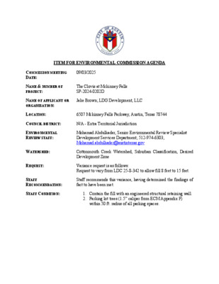
ITEM FOR ENVIRONMENTAL COMMISSION AGENDA COMMISSION MEETING DATE: 09/03/2025 NAME & NUMBER OF PROJECT: The Clovis at Mckinney Falls SP-2024-0202D NAME OF APPLICANT OR ORGANIZATION: Jake Brown; LDG Development, LLC LOCATION: 6507 Mckinney Falls Parkway, Austin, Texas 78744 COUNCIL DISTRICT: N/A - Extra Territorial Jurisdiction ENVIRONMENTAL REVIEW STAFF: Mohamad Abdulkader, Senior Environmental Review Specialist Development Services Department; 512-974-6303; Mohamad.abdulkader@austintexas.gov WATERSHED: REQUEST: Cottonmouth Creek Watershed, Suburban Classification, Desired Development Zone Variance request is as follows: Request to vary from LDC 25-8-342 to allow fill 8 feet to 15 feet. STAFF RECOMMENDATION: Staff recommends this variance, having determined the findings of fact to have been met. STAFF CONDITION: 1. Contain the fill with an engineered structural retaining wall. 2. Parking lot trees (1.5” caliper from ECM Appendix F) within 50 ft. radius of all parking spaces. Development Services Department Staff Recommendations Concerning Required Findings Project Name: The Clovis at McKinney Falls Ordinance Standard: Current code/WPO Variance Request: Request to vary from LDC 25-8-342 to allow fill 8 to 15 feet. A. Land Use Commission variance determinations from Chapter 25-8-41 of the City Code: 1. The requirement will deprive the applicant of a privilege available to owners of other similarly situated property with approximately contemporaneous development subject to similar code requirements. Yes. Other owners with similarly situated property with approximately contemporaneous development have access to the ROW. The Travis County Fire Marshall review is requiring two different access points to the property through both McKinney Falls Parkway and Dee Gabriel Collins Road. The northwest site of the property adjacent to Dee Gabriel Collins Rd. consists of slopes 25% and greater. The applicant proposes fill 8 to 15 feet to construct a driveway in compliance with fire access regulations that require finished driveway slopes to be 10% or less. 2. The variance: a. is not necessitated by the scale, layout, construction method, or other design decision made by the applicant, unless the design decision provides greater overall environmental protection than is achievable without the variance. Yes. The requested fill variance is necessitated by the lot configuration, existing topography, roadway connectivity, and the need for a second fire lane access. The proposed location of the second driveway is limited due to the Travis County Sight Distance restrictions at the Dee Gabriel Collins Rd. and McKinney Falls Parkway intersection. b. is the minimum deviation from the code requirement necessary to allow a reasonable use of the property; and Yes. The Clovis at McKinney Falls has been designed to minimally deviate from the code to establish grades allowable for a fire lane access and for the project to have two different access points. Only a very small portion compared to the whole of the property will require a variance to allow fill from 8 to 15 feet while the rest of the areas on both driveways and throughout the property will comply with LDC 25-8-341 and 25-8-342. The project will also include a retaining wall to contain the proposed fill to avoid and decrease soil and land disturbance which protects nearby trees. c. Does not create a significant probability of harmful environmental consequences; and Yes. The proposed site plan minimizes the probability of erosion being caused containing the filled material within a retaining wall, therefore minimizing soil disturbance while protecting nearby existing trees. 3. Development with the variance will result in water quality that is at least equal to the water quality achievable without the variance. Yes. The proposed design adheres to all water quality requirements outlines within City code and criteria and as such, will result in water quality that is at least equal to water quality achievable without the variance. Site run-off will be collected in a series of drains and piped to the partial Sedimentation/Filtration Pond with stacked detention. The Land Use Commission may grant a variance from a requirement of Article 7, Division 1 ( Critical Water Quality Zone Restrictions ), after determining that: B. Additional Land Use Commission variance determinations for a requirement of Section 25- 8-422 (Water Quality Transition Zone), Section 25-8-452 (Water Quality Transition Zone), Section 25-8-482 (Water Quality Transition Zone), Section 25-8-652 (Restrictions on Development Impacting Lake Austin, Lady Bird Lake, and Lake Walter E. Long), or Article 7, Division 1 (Critical Water Quality Zone Restrictions): 1. The criteria for granting a variance in Subsection (A) are met; N/A 2. 3. The requirement for which a variance is requested prevents a reasonable, economic use of the entire property; N/A The variance is the minimum deviation from the code requirement necessary to allow a reasonable, economic use of the entire property. N/A Staff Determination: Staff determines that the findings of fact have been met. Staff recommends the following conditions: • Retaining wall for any fill over 8 feet • Parking lot trees (1.5” caliper from ECM Appendix F) within 50 ft. radius of all parking spaces. Environmental Review Specialist Senior (DSD) Environmental Policy Program Manager (DSD) Interim Environmental Officer (WPD) Date: 8/8/2025 _____________________________ Mohamad Abdulkader _____________________________ Mike McDougal Date: 8/11/2025 _____________________________ Liz Johnston Date 8/11/2025 January 12, 2025 Mr. Ryan Soutter Development Services Dept. 6310 Wilhelmina Delco Drive Austin, TX 78752 Re: The Clovis at McKinney Falls (SP-2024-0202D) 6507 McKinney Falls Parkway Variance from LDC 25-8-342(8)(c) Good Day Mr. Soutter, On behalf of the owner, LDG Development, LLC, we are requesting a variance for fill more than eight (8) feet for the Dee Gabriel Collins Road driveway in order to provide a required access to the proposed development The Clovis at McKinney Falls, a multi-family affordable housing project (SP-2024-0202D), located at 6507 McKinney Falls Parkway, south of the intersection of McKinney Falls Parkway and Dee Gabriel Collins Road. The project consists of 264 units spread over 10 buildings, along with the clubhouse and pool. The site is located within the City of Austin 2-Mile Extraterritorial Jurisdiction (ETJ) and was most recently used for two single-family homes. The site is within the Cotton Mouth Creek watershed, a suburban watershed, and is not located over the Edwards Aquifer Recharge Zone. There are no CWQZ, WQTZ, nor CEFs located on the site. The Fire Marshal requires two means of access to the site from different streets, in this case, McKinney Falls Parkway and Dee Gabriel Collins Road. This is so that if one driveway were to be obstructed, the second driveway could be used to service the site. Most of the site is within the 0-15% slope category, but the steeper portions of the site are along the adjacent roadways, meaning that any site driveway must cross steep slopes to gain access to the site. The complication for the Dee Gabriel Collins driveway is that the maximum slope of a fire access roadway is 10%, and when crossing the steeper slopes, a fill condition is required to support the drive. In other words, due to the limit on the driveway slope, the grades driveway cannot keep up with the falling slope of the site and must have fill placed beneath it. Unfortunately, simply due to the existing topography, the fill amount for a small portion of the driveway exceeds the 8-foot limit prescribed by code LDC 25-8-342(8)(c). The maximum proposed amount of fill in this area is about 14.5 feet, and the fill is contained by retaining walls to limit the impact to the site and nearby trees. No other alternative location for the driveway is possible due to the Travis County driveway spacing and sight distance requirements from the intersection of McKinney Falls Parkway and Dee Gabriel Collins Road. The findings of fact are included in the attached Environmental Board Variance application template. We request your support for this variance request, and if you have any questions, please let us know. Sincerely, J Segura, PE Senior Technical Engineer 5707 Southwest Parkway, Building 2, Suite 250 Austin, Texas 78735 Tel: 512.306.8252 Fax: 512.306.7240 dunawayassociates.com Texas Registered Engineering Firm No: F-1114 § 25-8-342 FILL REQUIREMENTS. (A) Fill on a tract of land may not exceed four feet of depth, except: (1) in an urban watershed; (2) in a roadway right-of-way or rail line right-of-way; (3) under a foundation with sides perpendicular to the ground, or with pier and beam construction; (4) for construction of a water quality control or detention facility and appurtenances for conveyance such as swales, drainage ditches, and diversion berms, if: (a) the design and location of the facility within the site minimize the amount of fill over four feet; (b) the fill is the minimum necessary for the appropriate functioning of the facility; and (c) the fill is not located on a slope with a gradient of more than 15 percent or within 100 feet of a classified waterway; (5) for utility construction or a wastewater drain field; (6) in a state-permitted sanitary landfill located in the extraterritorial jurisdiction, if: (a) the fill is derived from the landfill operation; (b) the fill is not placed in a critical water quality zone or a 100-year floodplain; (c) the landfill operation has an erosion and restoration plan approved by the City; and (d) all other applicable City Code provisions are met; or (7) for fill associated with construction of a multi-use trail, if: (a) the fill is not located on a slope with a gradient of more than 15 percent or within 100 feet of a classified waterway; (b) the fill is limited to no more than eight feet in depth; (c) the fill is located in a public right-of-way or public easement; and (d) the trail is designed in accordance with the Environmental Criteria Manual. (8) for construction of a street or driveway necessary to provide primary access if: (a) the construction complies with Division 3 (Construction on Slopes) of this article; (b) the fill is not within a critical water quality zone; (c) the fill is limited to no more than eight feet in depth; (d) the fill over four feet is the minimum amount necessary to comply with safety access requirements and the horizontal and vertical curve requirements of the Transportation Criteria Manual; and (e) there is no other feasible alternative for the street or driveway location. (B) A fill area must be restored and stabilized. (C) Fill for a roadway must be contained within the roadway clearing width described in Section 25-8-322 (Clearing for a Roadway). 5707 Southwest Parkway, Building 2, Suite 250 Austin, Texas 78735 Tel: 512.306.8252 Fax: 512.306.7240 dunawayassociates.com Texas Registered Engineering Firm No: F-1114 February 28, 2013 ENVIRONMENTAL BOARD VARIANCE APPLICATION TEMPLATE Insert Applicant Variance Request Letter here. PROJECT DESCRIPTION Applicant Contact Information Name of Applicant Street Address City State ZIP Code Work Phone E-Mail Address Variance Case Information Case Name Case Number Address or Location Environmental Reviewer Name Applicable Ordinance Watershed Name Watershed Classification ☐Urban ☐ Suburban ☐Water Supply Suburban ☐Water Supply Rural ☐ Barton Springs Zone City of Austin | Environmental Board Variance Application Guide 1 Jake Brown; LDG Development, LLC6300 La Calma Drive, Suite 520Austin, TX 78752817-845-8026jbrown@ldgdevelopment.comThe Clovis at McKinney FallsSP-2024-0202D6507 McKinney Falls Parkway, 78744Ryan SoutterLDC 25-8-342(8)(c)Cotton Mouth Creek February 28, 2013 Edwards Aquifer Recharge Zone Edwards Aquifer Contributing Zone Distance to Nearest Classified Waterway Water and Waste Water service to be provided by Request Impervious cover square footage: acreage: percentage: Provide general description of the property (slope range, elevation range, summary of vegetation / trees, summary of the geology, CWQZ, WQTZ, CEFs, floodplain, heritage trees, any other notable or outstanding characteristics of the property) Clearly indicate in what way the proposed project ☐ Barton Springs Segment ☐ Northern Edwards Segment ☐ Not in Edwards Aquifer Zones ☐ Yes ☐ No The variance request is as follows (Cite code references: Existing ________ ________ ________ Proposed _________ _________ _________ City of Austin | Environmental Board Variance Application Guide 2 City of Austin+/- 1,900 LFTo allow fill of up to 15' for the driveway to providerequired emergency access.27,112352,3540.62248.08893.950.6The necessary fill on the Dee Gabriel Collins Road drivewayis 14.5 feet (Proposed 625 from 611).The 15.975-acre tract has 15.230 acres in the 0-15% slopecategory, 0.214 acres in the 15-25% slope category, 0.296 acres inthe 25-35% slope category, and 0.235 acres with slopes over 35%. The problem is that the steep slope categories are adjacent to allthe roadway frontages and must be crossed to enter the site.The site elevation ranges from 631 on the west, to 578 on the east. The site is within the Blackland Prairie ecological region of Texas(Gould, 1975). Woodland species are predominantly Cedar Elm,Hackberry, Chinaberry, Ashe Juniper, and Mesquite; there are noHeritage Trees on the site. Site geology is made up of CretaceousIgneous Rocks (Ki) - Pyroclastics altered to nontronite, basaltintruded into the pyroclastics of Pilot Knob volcano, and flows alongthe southern flans of the exhumed volcano.There are no waterways, no CWQZ, no WQTZ, and no CEFs on ornear the site.To allow fill from 8' to 15' for the driveway to providerequired emergency access. February 28, 2013 does not comply with current Code (include maps and exhibits) FINDINGS OF FACT As required in LDC Section 25‐8‐41, in order to grant a variance the Land Use Commission must make the following findings of fact: Include an explanation with each applicable finding of fact. Project: Ordinance: A. Land Use Commission variance determinations from Chapter 25‐8‐41 of the City Code: 1. The requirement will deprive the applicant of a privilege or the safety of property given to owners of other similarly situated property with approximately contemporaneous development. Yes/No [summary of justification for determination] 2. The variance: a) Is not based on a condition caused by the method chosen by the applicant to develop the property, unless the development method provides greater overall environmental protection than is achievable without the variance; Yes/No [summary of basis for determination] b) Is the minimum change necessary to avoid the deprivation of a privilege given to other property owners and to allow a reasonable use of the property; Yes/No [summary of basis for determination] c) Does not create a significant probability of harmful environmental consequences; and City of Austin | Environmental Board Variance Application Guide 3 The Clovis at McKinney FallsThe second driveway is a fire code requirement and the location of the driveway is mandatedby Travis County Sight Distance requirements from the McKinney Falls Parkway intersection.The fill is contained by a retaining wall to minimize site disturbance and tree removal. Otherthan the unusual amount of fill, the driveway is unremarkable. All other requirements of25-8-342(A)(8) have been met.LDC 25-8-342(A)(8)(c)The fire code requires two driveways to the site from separate streets for redundancy. Therefore, theDee Gabriel Collins Road Driveway, a fire access road, may not have a slope greater than 10% at anypoint. Unfortunately, the existing grades the drive must cross have a steeper slope, resulting in the highfills proposed. Denial of the variance would disallow the entire project since the site would not have therequired two access points. February 28, 2013 Yes/No [summary of basis for determination] 3. Development with the variance will result in water quality that is at least equal to the water quality achievable without the variance. Yes/No [summary of basis for determination] B. Additional Land Use Commission variance determinations for a requirement of Section 25‐8‐393 (Water Quality Transition Zone), Section 25‐8‐423 (Water Quality Transition Zone), Section 25‐8‐453 (Water Quality Transition Zone), or Article 7, Division 1 (Critical Water Quality Zone Restrictions): 1. The criteria for granting a variance in Section A are met; Yes/No [summary of basis for determination] 2. The requirement for which a variance is requested prevents a reasonable, economic use of the entire property; and Yes/No [summary of basis for determination] 3. The variance is the minimum change necessary to allow a reasonable, economic use of the entire property. Yes/No [summary of basis for determination] **Variance approval requires all above affirmative findings. City of Austin | Environmental Board Variance Application Guide 4 The fill is contained by a retaining wall to minimize site disturbance and tree removal. By being contained by a wall, the 15-foot fill does not impact the environment anymore than a 8-foot fill would.The driveway slopes into the site and the site's water quality facility. February 28, 2013 A Exhibits for Board Backup and/or Presentation Please attach and paginate. o Aerial photos of the site (backup and presentation) o Site photos (backup and presentation) o Aerial photos of the vicinity (backup and presentation) o Context Map—A map illustrating the subject property in relation to developments in the vicinity to include nearby major streets and waterways (backup and presentation) o Topographic Map ‐ A topographic map is recommended if a significant grade change on the subject site exists or if there is a significant difference in grade in relation to adjacent properties. (backup and presentation) o For cut/fill variances, a plan sheet showing areas and depth of cut/fill with topographic elevations. (backup and presentation) o Site plan showing existing conditions if development exists currently on the property (presentation only) o Proposed Site Plan‐ full size electronic or at least legible 11x17 showing proposed development, include tree survey if required as part of site or subdivision plan (backup and presentation) o Environmental Map – A map that shows pertinent features including Floodplain, CWQZ, WQTZ, CEFs, Setbacks, Recharge Zone, etc. (backup and presentation) o An Environmental Assessment pursuant to ECM 1.3.0 (if required by 25‐8‐121) (backup only) o Applicant’s variance request letter (backup only) City of Austin | Environmental Board Variance Application Guide 5 Site Location Map 5707 Southwest Parkway, Building 2, Suite 250 Austin, Texas 78735 Tel: 512.306.8252 Fax: 512.306.7240 dunawayassociates.com Texas Registered Engineering Firm No: F-1114 Aerial Photo 5707 Southwest Parkway, Building 2, Suite 250 Austin, Texas 78735 Tel: 512.306.8252 Fax: 512.306.7240 dunawayassociates.com Texas Registered Engineering Firm No: F-1114 Property Profile Clovis at McKinney Falls Legend Appraisal Districts TCAD Parcels 0 500 1000 ft 1/13/2025 This product is for informational purposes and may not have been prepared for or be suitable for legal, engineering, or surveying purposes. It does not represent an on-the-ground survey. This product has been produced by the City of Austin for the sole purpose of geographic reference. No warranty is made by the City of Austin regarding specific accuracy or completeness. Notes SP-2024-0202D Driveway locationDriveway locationDee GabrielMcKinney Falls ParkwayCollins Road Existing Conditions 5707 Southwest Parkway, Building 2, Suite 250 Austin, Texas 78735 Tel: 512.306.8252 Fax: 512.306.7240 dunawayassociates.com Texas Registered Engineering Firm No: F-1114 Site Photos 5707 Southwest Parkway, Building 2, Suite 250 Austin, Texas 78735 Tel: 512.306.8252 Fax: 512.306.7240 dunawayassociates.com Texas Registered Engineering Firm No: F-1114 Approximatedriveway locationDee Gabriel Collins RoadFacing East McKinney Falls Parkwayatop the embankmentDee Gabriel Collins Roadatop the embankment Site Topography and Fill Exhibit 5707 Southwest Parkway, Building 2, Suite 250 Austin, Texas 78735 Tel: 512.306.8252 Fax: 512.306.7240 dunawayassociates.com Texas Registered Engineering Firm No: F-1114 Environmental Resource Inventory 5707 Southwest Parkway, Building 2, Suite 250 Austin, Texas 78735 Tel: 512.306.8252 Fax: 512.306.7240 dunawayassociates.com Texas Registered Engineering Firm No: F-1114 11 Matt Patyk3/9/2021Dunawaympatyk@dunaway.com817-647-5508 Project No. B006469.001 ©2021 Dunaway Associates, L.P. Appendix A: Site Maps March 9, 2021 Ko 608 608 626 618 616 612 624 614 630 628 610 602 604 600 598 596 590 588 606 594 620 608 586 584 580 592 582 580 578 Ki Legend Approximate Project Boundary Figure 1 LDG Clovis at McKinney Falls Environmental Resource Inventory Site Specific Geologic Map 3/8/2021 Source: Nearmap 2021 Aerial Travis County & Geologic Database of Texas 0 75 150 Feet DALP Project # B006469.001 Path: G:\Production4000\006400\6469\001\Environmental\ERI Report\GIS\Required Figures\Figure 1 - Geology Map.mxd Legend Approximate Project Boundary Figure 2 LDG Clovis at McKinney Falls Environmental Resource Inventory 1996 Aerial Map 3/8/2021 Source: Texas TOP 1996 Aerial 0 75 150 Feet DALP Project # B006469.001 Path: G:\Production4000\006400\6469\001\Environmental\ERI Report\GIS\Required Figures\Figure 2 - Historic Aerial.mxd BtB HeC2 FhF3 HfC AsC2 HfB Legend Approximate Project Boundary Soil Unit Boundary Soil Unit FhF3 HeC2 HfB HfC Soil Description Ferris-Heiden complex, 8 to 20 percent slopes, severely eroded Heiden clay, 3 to 5 percent slopes Behring clay, 1 to 3 percent slopes Behring clay, 3 to 5 percent slopes Figure 3 LDG Clovis at McKinney Falls Environmental Resource Inventory Soils Map 3/8/2021 Source: Nearmap 2020 Aerial & USDA Soils Travis County 0 75 150 Feet DALP Project # B006469.001 Path: G:\Production4000\006400\6469\001\Environmental\ERI Report\GIS\Required Figures\Figure 3 - Soils.mxd 630 628 610 602 604 600 598 596 590 588 608 608 626 618 616 612 624 614 606 594 620 608 578 586 584 580 On-Site Water Well Off-Site Water Well 592 582 580 Legend Approximate Project Boundary Water Well Location Figure 4 LDG Clovis at McKinney Falls Environmental Resource Inventory 2-Foot Topographic Map 3/8/2021 Source: Nearmap 2020 Aerial Travis County 0 75 150 Feet DALP Project # B006469.001 Path: G:\Production4000\006400\6469\001\Environmental\ERI Report\GIS\Required Figures\Figure 4 - Topo.mxd