20250806-002: RBI Austin Youth Development Complex Applicant Exhibits Part1 — original pdf
Backup
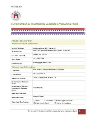
March 28, 2025 ENVIRONMENTAL COMMISSION VARIANCE APPLICATION FORM PROJECT DESCRIPTION Applicant Contact Information Name of Applicant Street Address City State ZIP Code Work Phone E-Mail Address Katherine Lauer, P.E., GarzaEMC 9442 N Capital of Texas Hwy, Plaza I, Suite 340 Austin, TX 78759 512-298-3284 klauer@garzaemc.com Variance Case Information RBI Austin Child Development Complex SP-2022-0567C 7401 Loyola Lane, Austin, TX John Clement Case Name Case Number Address or Location Environmental Reviewer Name Environmental Resource Management Reviewer Name Applicable Ordinance Watershed Name Walnut Creek Watershed Classification ☐Urban X Suburban ☐Water Supply Suburban ☐Water Supply Rural ☐ Barton Springs Zone City of Austin | Environmental Commission Variance Application Guide 1 March 28, 2025 Edwards Aquifer Recharge Zone ☐ Barton Springs Segment ☐ Northern Edwards Segment X Not in Edwards Aquifer Zones Edwards Aquifer Contributing Zone Distance to Nearest Classified Waterway Water and Waste Water service to be provided by ☐ Yes X No The onsite waterway is classified as an intermediate waterway Austin Water – Wastewater SER approval The variance request is as follows (Cite code references): TITLE 25. – LAND DEVELOPMENT CHAPTER 25-8. – ENVIRONMENT SUBCHAPTER A. – WATER QUALITY Request ARTICLE 7. – REQUIREMENTS IN ALL WATERSHEDS Division 1 – Waterway and Floodplain Protection Section 25-8-261(G) CRITICAL WATER QUALITY ZONE DEVELOPMENT & Section 25-8-263 FLOODPLAIN MODIFICATION Proposal is to allow grading modification and the addition of a crossing through the CWQZ and the floodplain located within the CWQZ. Existing 0 0 0% Proposed 234,614 5.386 31.4% The site is currently undeveloped grassland and 17.14 acres. The site is along the Imagine Austin Corridor with the corridor located north of the site along Loyola Lane. Per surveyed topographic data, there is an elevation change of approximately 35’ from the highest point (524’) of the site to the lowest point (477’) of the draw City of Austin | Environmental Commission Variance Application Guide 2 Impervious cover square footage: acreage: percentage: Provide general description of the property (slope range, elevation range, summary of vegetation / trees, March 28, 2025 summary of the geology, CWQZ, WQTZ, CEFs, floodplain, heritage trees, any other notable or outstanding characteristics of the property) that runs east to west through the center of the site. There are three creek channels that converge on-site then flow west through the center of the property. Portions of the dry creek bed have steeper slopes. The lot has both gentle and steep slopes in the range of 0-15%. The site contains an Erosion Hazard Zone, Critical Water Quality Zone that runs through the center of the site, and wetlands within the eastern portion of the site. The site contains a heritage tree which aligns with the proposed Loyola Lane driveway. The site contains a 100-year fully developed floodplain along the creek centerlines. Per the Functional Assessment of Floodplain Health, the area of floodplain proposed for modification is currently in good condition. City of Austin | Environmental Commission Variance Application Guide 3 March 28, 2025 Clearly indicate in what way the proposed project does not comply with current Code (include maps and exhibits) This project proposes grading and a crossing within the CWQZ and modification of the 100-year full developed floodplain within the CWQZ. This site is located in the Colony Park Station Imagine Austin Center and off of the Loyola Lane Imagine Austin Corridor. This designation permits a street or driveway to cross the CWQZ within the property in accordance with LDC 25-8-262.D, however, a variance is required to allow a bridge crossing and associated floodplain modifications within the CWQZ. In order to provide safe access to the southern half of the property, we request a variance to allow modifications of the floodplain within the CWQZ. Floodplain modifications within the CWQZ is necessary not only to make the crossing but to preserve a heritage tree and avoid impacting a CEF buffer within the property with the crossing. FINDINGS OF FACT As required in LDC Section 25-8-41, in order to grant a variance the Land Use Commission must make the following findings of fact: Include an explanation with each applicable finding of fact. Project: RBI Austin Child Development Complex Ordinance: A. Land Use Commission variance determinations from Chapter 25-8-41 of the City Code: 1. The requirement will deprive the applicant of a privilege available to owners of similarly situated property with approximately contemporaneous development subject to similar code requirements. Yes / No [provide summary of justification for determination] The site is located within the Imagine Austin Comprehensive Plan which allows a necessary crossing within the Critical Water Quality Zone per section 25-8-262 of Title 25 in the City of Austin Land Development Code. The Imagine Austin Comprehensive Plan was adopted by Ordinance No. 20120614-058 which aims to facilitate the development of the corridor for the benefit of the community. A non-profit organization is proposing a baseball and softball facility for underserved youth in the Austin community and aims to add value to the local area’s population. This variance will allow City of Austin | Environmental Commission Variance Application Guide 4 March 28, 2025 access to and development of the southern half of the subject tract similar to the other properties along the Imagine Austin Corridor. This site is constrained to the proposed driveway location due to the existing CEF buffer that occupies the eastern portion of the site, a hazardous pipeline setback, the creeks running east to west through the middle of the site, a protected tree, and a heritage tree located within 100 feet of a classified waterway on-site. The proposed crossing will be in the form of a bridge that spans the creek but must form a Y within the CWQZ to preserve a protected tree and heritage tree. The impacts of the bridge on the 100-year fully developed floodplain requires grading modification within the CWQZ in order to provide safe access above the 100- year floodplain elevation to the southern half of the site. The floodplain modification within the CWQZ required to preserve the heritage tree and construct the bridge impacts the grading within the floodplain. The site plan layout is limited by the existing environmental features on the site which includes multiple waterways (creeks), a heritage tree, a protected tree, CEF buffers, EHZ, and CWQZ. According to the Functional Assessment of Floodplain Health, the area of floodplain proposed for modification is currently in good condition. The site proposes a baseball field, softball field, small building, associated drives & parking, and required water quality controls. 2. The variance: a) Is not necessitated by the scale, layout, construction method, or other design decision made by the applicant, unless the design decision provides greater overall environmental protection than is achievable without the variance; Yes / No [provide summary of justification for determination] The variance is necessitated to: 1. Provide pedestrian and vehicular access into the site from the public right- of-way and Imagine Austin Corridor on Loyola Lane. Access will be provided via a driveway from Loyola Lane that crosses the creek via a bridge. 2. Provide pedestrian and vehicular access through the site in a way that preserves an existing heritage and protected tree and reduces impacts to the greatest extent possible to the CEF buffer, EHZ, floodplain, and CWQZ. The location of the crossing is limited by the existing CEF buffer that occupies the eastern portion of the site from the north to south boundaries, the creeks running east to west through the middle of the site, the CWQZ, EHZ, a protected tree, and a heritage tree located within 100 feet of a classified waterway. All of these constraints limit the location of the crossing as well as it’s Y shape configuration. The protected tree and heritage tree are adjacent to each other. Both are located south of the waterway and outside of the CEF buffer meaning that it City of Austin | Environmental Commission Variance Application Guide 5 March 28, 2025 resides in the limited area where proposed site improvements (buildings, fields, ponds, parking, etc.) are allowed. Per § 25-8-641 of the City of Austin Land Development Code, removal of a heritage is prohibited unless a variance is approved. The condition of the heritage tree would make it unlikely for a variance to be approved. There is not an alternative route around the classified waterway to access the southern half of the site due to multiple constraints and the fact that the classified waterway runs east to west across the entire site. The only public right-of-way is located along the northern site border. There is an existing City of Austin property to the east, and the properties to the south and west are privately owned with a residential use. There are three waterways that converge near the center of the site, so the only space to cross the waterways is along the western half of the site. The CWQZ, floodplain, & EHZ surround the waterway and must be crossed. The majority of developable land on the site is located south of the CWQZ & EHZ areas. Development of land on the north side of the CWQZ & EHS is restricted due to limited space and its proximity to a hazardous pipeline setback along Loyola Lane. The hazardous pipeline setback does not allow for buildings to be placed within it. The space on the northern half of the site that lies between the CWQZ/EHZ and the hazardous pipeline setback is not enough space for the proposed fields, building, parking and drives. b) Is the minimum deviation from the code requirement necessary to allow a reasonable use of the property; Yes / No [provide summary justification for determination] The challenge to meet the requirements of the City of Austin Wetlands, Floodplain, and Environmental departments has led to the proposed site plan configuration. The location of the crossing grants compliance with floodplain requirements, protected tree, and heritage tree criteria and limits development within the CEF buffer, EHZ, and CWQZ. The amount of proposed fill within the floodplain is less than 1% of the total floodplain volume per the requirements from the Floodplain Department. In order to achieve <1% net fill of the existing floodplain, grading within the floodplain had to be increased to accommodate the bridge structure and roadway across the creek. Without the waterway crossing and associated floodplain grading, the southern half of the site would be unable to be developed or accessed. c) Does not create a significant probability of harmful environmental consequences. Yes / No [provide summary justification for determination] City of Austin | Environmental Commission Variance Application Guide 6 March 28, 2025 The crossing location provides minimal impacts to the environmental aspects of the site. The heritage tree and protected trees are allowed to remain, the CEF buffer is undisturbed by the crossing, and there is <1% of proposed net fill of the existing floodplain volume per the Floodplain requirements. The crossing and floodplain modifications do not have any adverse effects on the off-site floodplain. The disturbed area will be revegetated per standards provided by the Environmental department. A riparian restoration plan will be proposed for the floodplain modifications caused by the crossing & bridge impacts. Any restoration or mitigation that cannot be provided on-site will be paid into the Riparian Restoration fund per the standards in Section 1.7.5 of the Environmental Criteria Manual. Per zoning case C14-2020-0080, the zoning was changed from SF-2 (Single Family Residence – Standard Lot) to GR (Community Commercial). Under SF-2 zoning, the maximum allowable impervious cover is 45%, and GR zoning allows up to 90%. The current site plan is proposing 31% impervious cover under GR zoning which is significantly lower than what is allowed. The turf baseball field is included as impervious cover and makes up a large part of the impervious cover. The remaining proposed impervious cover is limited to what is necessary for the functionality of the site and what is required by COA Land Development Code. 3. Development with the variance will result in water quality that is at least equal to the water quality achievable without the variance. Yes / No [provide summary justification for determination] Development with the variance will not have any foreseeable effects on water quality. Runoff being conveyed to the floodplain will be treated by passing through stormwater quality measures. B. Additional Land Use Commission variance determinations for a requirement of Section 25-8-422 (Water Quality Transition Zone), Section 25-8-452 (Water Quality Transition Zone), Article 7, Division 1 (Critical Water Quality Zone Restrictions), or Section 25-8-368 (Restrictions on Development Impacting Lake Austin, Lady Bird Lake, and Lake Walter E. Long): 1. The criteria for granting a variance in Subsection (A) are met; Yes / No [provide summary of justification for determination] As stated previously, The Imagine Austin Comprehensive Plan aims to facilitate the development of the corridor for the benefit of the community. A non-profit organization is proposing a baseball and softball facility for underserved youth in the Austin community and aims to add value to the local area’s population. The variance is due to the site constraints with environmental features in order to allow reasonable use of the property. The development will not impact water quality. City of Austin | Environmental Commission Variance Application Guide 7 March 28, 2025 2. The requirement for which a variance is requested prevents a reasonable, economic use of the entire property; Yes / No [provide summary of justification for determination] The site will serve the community and is being developed by a non-profit organization. The underserved youth of Austin will use the site for recreation. The proposed use of a baseball/softball field requires adequate space for fields, sport stands, and associated buildings, and there is not enough space north of the creek for all necessary improvements. The lack of access to the southern half of the site means that the property cannot be used at all for its proposed purpose. 3. The variance is the minimum deviation from the code requirement necessary to allow a reasonable, economic use of the entire property. Yes / No [provide summary of justification for determination] The existing environmental features and on-site waterways limit the developable area. Removing the crossing would make the site unusable for the proposed improvements. The north portion of the site that is outside of the CEF, CWQZ, & EHZ does not provide enough space for the sports fields and is located within a restricted pipeline area which restricts the development of structures. The proposed driveway and access from Loyola Lane will require modification of the floodplain within the CWQZ. The entrance is limited due to the surrounding sites and the waterways. **Variance approval requires all above affirmative findings. City of Austin | Environmental Commission Variance Application Guide 8 June 4, 2025 ENVIRONMENTAL COMMISSION VARIANCE APPLICATION FORM PROJECT DESCRIPTION Applicant Contact Information Name of Applicant Street Address City State ZIP Code Work Phone E-Mail Address Katherine Lauer, P.E., GarzaEMC 9442 N Capital of Texas Hwy, Plaza I, Suite 340 Austin, TX 78759 512-298-3284 klauer@garzaemc.com Variance Case Information Case Name Case Number Address or Location Environmental Reviewer Name Environmental Resource Management Reviewer Name Applicable Ordinance RBI Austin Child Development Complex SP-2022-0567C 7401 Loyola Lane, Austin, TX Enrique Maiz-Torres Watershed Protection Ordinance - Current Code Watershed Name Walnut Creek Watershed Classification ☐Urban X Suburban ☐Water Supply Suburban ☐Water Supply Rural ☐ Barton Springs Zone City of Austin | Environmental Commission Variance Application Guide 1 June 4, 2025 Edwards Aquifer Recharge Zone ☐ Barton Springs Segment ☐ Northern Edwards Segment X Not in Edwards Aquifer Zones Edwards Aquifer Contributing Zone Distance to Nearest Classified Waterway Water and Waste Water service to be provided by ☐ Yes X No The onsite waterway is classified as an intermediate waterway Austin Water – Wastewater SER approval The variance request is as follows (Cite code references): Code of Ordinances, updated 2024-03-25, effective 2023-12-25, Supplement No. 164 TITLE 25. – LAND DEVELOPMENT CHAPTER 25-8. – ENVIRONMENT Request SUBCHAPTER A. – WATER QUALITY ARTICLE 7. – REQUIREMENTS IN ALL WATERSHEDS Division 5. – Cut, Fill, and Spoil. Section 25-8-341 CUT REQUIREMENTS & Section 25-8-342 FILL REQUIREMENTS Proposal is to allow cut & fill over 4 feet to 8 feet within the Critical Water Quality Zone to develop this tract as shown. Existing 0 0 0% Proposed 234,614 5.386 31.4% The site is currently undeveloped grassland and 17.14 acres. The site is along the Imagine Austin Corridor with the corridor located north of the site along Loyola Lane. City of Austin | Environmental Commission Variance Application Guide 2 Impervious cover square footage: acreage: percentage: Provide general description of the property (slope range, elevation June 4, 2025 range, summary of vegetation / trees, summary of the geology, CWQZ, WQTZ, CEFs, floodplain, heritage trees, any other notable or outstanding characteristics of the property) Per surveyed topographic data, there is an elevation change of approximately 35’ from the highest point (524’) of the site to the lowest point (477’) of the draw that runs east to west through the center of the site. There are three creek channels that converge on-site then flow west through the center of the property. Portions of the dry creek bed have steeper slopes. The lot has both gentle and steep slopes in the range of 0-15%. The site contains an Erosion Hazard Zone, Critical Water Quality Zone that runs through the center of the site, and wetlands within the eastern portion of the site. The site contains a heritage tree which aligns with the proposed Loyola Lane driveway. The site contains a 100-year fully-developed floodplain along the creek centerlines. Per the Functional Assessment of Floodplain Health, the area of floodplain proposed for modification is currently in good condition. City of Austin | Environmental Commission Variance Application Guide 3 June 4, 2025 Clearly indicate in what way the proposed project does not comply with current Code (include maps and exhibits) The project proposes cut and fill within 100 feet of a classified waterway. This site is located in the Colony Park Station Imagine Austin Center and off of the Loyola Lane Imagine Austin Corridor. This designation permits a street or driveway to cross the CWQZ within the property in accordance with LDC 25-8-262.D, however, a variance is required to allow cut and fill in excess of 4' within 100 feet of a classified waterway to construct a driveway crossing to access the southern half of the site. A bridge in excess of 8' in height is required to safely cross the CWQZ above the 100 year floodplain elevation. In order to provide safe access to the southern half of the property, we request a variance to allow cut and fill in excess of 4' within 100' of the CWQZ centerline. Cut and fill within the CWQZ is necessary not only to make the crossing but to preserve a heritage tree and avoid impacting a CEF buffer within the property with the crossing. FINDINGS OF FACT As required in LDC Section 25-8-41, in order to grant a variance the Land Use Commission must make the following findings of fact: Include an explanation with each applicable finding of fact. Project: RBI Austin Child Development Complex Ordinance: A. Land Use Commission variance determinations from Chapter 25-8-41 of the City Code: 1. The requirement will deprive the applicant of a privilege available to owners of similarly situated property with approximately contemporaneous development subject to similar code requirements. Yes / No [provide summary of justification for determination] The site is located within the Imagine Austin Comprehensive Plan which allows a necessary crossing within the Critical Water Quality Zone per section 25-8-262 of Title 25 in the City of Austin Land Development Code. The Imagine Austin Comprehensive Plan was adopted by Ordinance No. 20120614-058 which aims to facilitate the City of Austin | Environmental Commission Variance Application Guide 4 June 4, 2025 development of the corridor for the benefit of the community. A non-profit organization is proposing a baseball and softball facility for underserved youth in the Austin community and aims to add value to the local area’s population. This variance will allow access to and development of the southern half of the subject tract similar to the other properties along the Imagine Austin Corridor. This site is constrained to the proposed driveway location due to the existing CEF buffer that occupies the eastern portion of the site, the hazardous pipeline setback, the creeks running east to west through the middle of the site, a protected tree, and a heritage tree located within 100 feet of a classified waterway on-site. The proposed crossing will be in the form of a bridge that spans the creek but must form a Y within the CWQZ to preserve a protected tree and heritage tree. The impacts of the bridge on the 100-year fully-developed floodplain requires cut and fill over 4’ within the CWQZ in order to provide safe access above the 100-year floodplain elevation to the southern half of the site; engineering efforts were made to the grading to minimize the areas requiring cut and fill >4’ within the CWQZ. Additionally, the bridge crossing design has been revised to keep proposed fill under 8’. The amount of fill required to preserve the heritage tree, protected tree, and construct the bridge impacts the floodplain and requires approximately the same amount of cut to balance the floodplain volume across the site. In addition to the cut and fill >4’ within the CWQZ & classified waterway, other areas of the site require cut greater than 4’ such as the proposed baseball field, covered practice field, water quality ponds, and for a section of the driveway. The grading on the two proposed sports fields is necessary to achieve grading that allows for the use of these sports fields. An administrative variance has been approved for the areas outside of the CWQZ requiring cut and fill over 4’. The site plan layout is limited by the existing environmental features on the site which includes multiple waterways (creeks), a heritage tree, a protected tree, CEF buffers, EHZ, and CWQZ. The site proposes a baseball field, softball field, small building, associated drives & parking, and required water quality controls. 2. The variance: a) Is not necessitated by the scale, layout, construction method, or other design decision made by the applicant, unless the design decision provides greater overall environmental protection than is achievable without the variance; Yes / No [provide summary of justification for determination] The variance is necessitated to: 1. Provide pedestrian and vehicular access into the site from the public right- of-way and Imagine Austin Corridor on Loyola Lane. Access will be provided via a driveway from Loyola Lane that crosses the creek via a bridge. City of Austin | Environmental Commission Variance Application Guide 5 June 4, 2025 2. Provide pedestrian and vehicular access through the site in a way that preserves an existing heritage tree and reduces impacts to the greatest extent possible to the CEF buffer, EHZ, and CWQZ. The location of the crossing is limited by the existing CEF buffer that occupies the eastern portion of the site from the north to south boundaries, the creeks running east to west through the middle of the site, the CWQZ, EHZ, a protected tree, and a heritage tree located within 100 feet of a classified waterway. All of these constraints limit the location of the crossing as well as it’s Y shape configuration. The majority of the crossing resides within the CWQZ where grading exceeds 4’, but the proposed grading within the CWQZ has been minimized as much as possible while also being compliant with compensatory floodplain volume requirements. The heritage tree is located south of the waterway and outside of the CEF buffer meaning that is resides in the limited area where proposed site improvements (buildings, fields, ponds, parking, etc.) are allowed. Per § 25- 8-641 of the City of Austin Land Development Code, removal of a heritage is prohibited unless a variance is approved. The condition of the heritage tree would make it unlikely for a variance to be approved, and the cost of mitigation is not reasonable compared to the proposed site use by a non- profit. There is not an alternative route around the classified waterway to access the southern half of the site due to multiple constraints and the fact that the classified waterway runs east to west across the entire site. The only public right-of-way is located along the northern site border. There is an existing City of Austin property to the east, and the properties to the south and west are privately owned with a residential use. There are three waterways that converge near the center of the site, so the only space to cross the waterways is along the western half of the site. The CWQZ & EHZ surround the waterway and must be crossed. The majority of developable land on the site is located south of the CWQZ & EHZ areas. Development of land on the north side of the CWQZ & EHS is restricted due to limited space and its proximity to a hazardous pipeline setback along Loyola Lane. The hazardous pipeline setback does not allow for buildings to be placed within it. The space on the northern half of the site that lies between the CWQZ/EHZ and the hazardous pipeline setback is not enough space for the proposed fields, building, parking and drives. b) Is the minimum deviation from the code requirement necessary to allow a reasonable use of the property; Yes / No City of Austin | Environmental Commission Variance Application Guide 6 June 4, 2025 [provide summary of justification for determination] The challenge to meet the requirements of the City of Austin Wetlands, Floodplain, and Environmental departments has led to the proposed site plan configuration. The location of the crossing grants compliance with floodplain requirements and heritage tree criteria and limits development within the CEF buffer, EHZ, and CWQZ. Without the waterway crossing and associated cut and fill >4’ within the CWQZ, the southern half of the site would be unable to be developed or accessed. c) Does not create a significant probability of harmful environmental consequences. Yes / No [provide summary justification for determination] Although grading within the CWQZ will disturb the natural condition of the area adjacent to and under the proposed crossing, efforts have been made to keep the proposed cut and fill ranging from 4-8 feet to minimal areas and depths. Previously a bridge pillar showed fill >8’ within the CWQZ, but that has been revised to be <8’ of fill. Per the specific methods mentioned below, restoration to these areas within the CWQZ is proposed to reduce environmental impacts from cut and fill >4’. The crossing location provides minimal impacts to the environmental aspects of the site. The heritage tree and protected tree are allowed to remain, and the CEF buffer is undisturbed by the crossing. The disturbed area will be revegetated per standards provided by the Environmental department. A riparian restoration plan will be proposed for the floodplain modifications caused by the crossing & bridge impacts. Any restoration or mitigation that cannot be provided on-site will be paid into the Riparian Restoration fund per the standards in Section 1.7.5 of the Environmental Criteria Manual. Per zoning case C14-2020-0080, the zoning was changed from SF-2 (Single Family Residence – Standard Lot) to GR (Community Commercial). Under SF-2 zoning, the maximum allowable impervious cover is 45%, and GR zoning allows up to 90%. The current site plan is proposing 31% impervious cover under GR zoning which is significantly lower than what is allowed. The turf baseball field is included as impervious cover and makes up a large part of the impervious cover. The remaining proposed impervious cover is limited to what is necessary for the functionality of the site and what is required by COA Land Development Code 3. Development with the variance will result in water quality that is at least equal to the water quality achievable without the variance. City of Austin | Environmental Commission Variance Application Guide 7 June 4, 2025 Yes / No [provide summary justification for determination] Development with the variance will not have any foreseeable effects on water quality. Runoff being conveyed to the floodplain will be treated by passing through stormwater quality measures. B. Additional Land Use Commission variance determinations for a requirement of Section 25-8-422 (Water Quality Transition Zone), Section 25-8-452 (Water Quality Transition Zone), Article 7, Division 1 (Critical Water Quality Zone Restrictions), or Section 25-8-368 (Restrictions on Development Impacting Lake Austin, Lady Bird Lake, and Lake Walter E. Long): 1. The criteria for granting a variance in Subsection (A) are met; Yes / No [provide summary of justification for determination] N/A 2. The requirement for which a variance is requested prevents a reasonable, economic use of the entire property; Yes / No [provide summary of justification for determination] N/A 3. The variance is the minimum deviation from the code requirement necessary to allow a reasonable, economic use of the entire property. Yes / No [provide summary of justification for determination] N/A **Variance approval requires all above affirmative findings. City of Austin | Environmental Commission Variance Application Guide 8 March 28, 2025 A Exhibits for Commission Variance o Aerial photos of the site o Site photos o Aerial photos of the vicinity o Context Map—A map illustrating the subject property in relation to developments in the vicinity to include nearby major streets and waterways o Topographic Map - A topographic map is recommended if a significant grade change on the subject site exists or if there is a significant difference in grade in relation to adjacent properties. o For cut/fill variances, a plan sheet showing areas and depth of cut/fill with topographic elevations. o Site plan showing existing conditions if development exists currently on the property o Proposed Site Plan- full size electronic or at least legible 11x17 showing proposed development, include tree survey if required as part of site or subdivision plan o Environmental Map – A map that shows pertinent features including Floodplain, CWQZ, WQTZ, CEFs, Setbacks, Recharge Zone, etc. o An Environmental Resource Inventory pursuant to ECM 1.3.0 (if required by 25-8-121) o Applicant’s variance request letter City of Austin | Environmental Commission Variance Application Guide 9 EXHIBITS TABLE OF CONTENTS 1 - AERIAL SITE PHOTO 2 - AERIAL VICINITY PHOTO 3 - CONTEXT MAP 4 - TOPOGRAPHIC MAP 5 - CUT FILL MAPS 6 - PROPOSED SITE PLAN 7 - ENVIRONMENTAL MAP 8 - ERI 9 - SITE PHOTOS10 - FUNCTIONAL ASSESSMENT OF FLOODPLAIN HEALTH AERIAL SITE PHOTO AERIAL PHOTOSITE AERIAL VICINITY PHOTO Vicinity Map - RBI CHILD DEVELOPMENT COMPLEX Legend 7401 Loyola Ln Austin Fire Station 26 Overton Elementary School Image © 2024 Airbus Image © 2024 Airbus Image © 2024 Airbus ➤➤ N N 1000 ft CONTEXT MAP Property Profile Context Map Legend Property Street Labels Review Cases Site Plan Review Cases (All) Long Range Planning Imagine Austin Corridors Environmental 1 Creek Centerlines Lakes Notes 0 5/1/2024 0.5 1 mi This product is for informational purposes and may not have been prepared for or be suitable for legal, engineering, or surveying purposes. It does not represent an on-the-ground survey. This product has been produced by the City of Austin for the sole purpose of geographic reference. No warranty is made by the City of Austin regarding specific accuracy or completeness. SITE TOPOGRAPHIC &SLOPE MAPS TREE LIST 5 2 1 e t i u S , . l d v B o I N O S V E R I t l i a R 8 0 7 7 2 9 5 2 - 8 9 2 ) 2 1 5 ( x a F 4 8 2 3 - 8 9 2 ) 2 1 5 ( . l e T 4 2 0 2 t h g i r y p o C © C L L , C M E a z r a G 9 2 6 4 1 - F # E P B T 5 3 7 8 7 s a x e T , n i t s u A LOYOLA LANE INT# 7964 LOYOLA LANE INT# 7965 EXISTING DEMO DESCRIPTION LEGEND 03/28/2024 . O N E T A D I I & S N O T D N O C G N T S X E I I DEMOLITION KEYNOTES DEMOLITION NOTES: X E L P M O C T N E M P O L E V E D D L I H C N T S U A I I B R E N A L A L O Y O L 1 0 4 7 I N A L P N O T I L O M E D I S E T R E P O R P E T A L P E M O H FOR CITY USE ONLY: 1 0 0 0 0 - 6 1 6 3 1 1 : . O N T C E J O R P : Y B D E N G S E D I : Y B N W A R D : C Q / A Q SHEET 06 61 OF SP 2022-0567C M A 9 5 : 0 1 4 2 , 9 1 r a M n o w e h e a l y b d e i f i d o m g w d . O M E D - 1 0 0 0 0 - 6 1 6 3 1 1 \ D A C - 0 0 \ l i i v C \ 1 0 0 0 0 - 6 1 6 3 1 1 \ : V LOYOLA LANE DETENTION POND 1 N E D R A G N A R I DETENTION POND 2 DETENTION POND 3 BIOFILTRATION POND 1 I N O T A R T L I F EDUCATION 2,189 SF FFE: 498.98 OFFICE 2,189 SF FFE: 498.98 RECREATIONAL 2,189 SF FFE: 498.98 FIRE ROOM COVERED PRACTICE FIELD 30,516 SF FFE: 499.75 / I N O T A T N E M D E S I 1 D N O P BASEBALL FIELD 101,352 SF F F E : 5 0 2 . 5 0 5 7 5 S F P R E S S B O X 1 3 5 S F , D U G F F E : 4 9 7 O U T 1 . 2 5 DUG OUT 2 135 SF, FFE: 498.85 2 9 5 2 - 8 9 2 ) 2 1 5 ( x a F 4 8 2 3 - 8 9 2 ) 2 1 5 ( . l e T 4 2 0 2 t h g i r y p o C © C L L , C M E a z r a G 9 2 6 4 1 - F # E P B T 5 3 7 8 7 s a x e T , n i t s u A 5 2 1 e t i u S l , . d v B o t l a R 8 0 7 7 i I N O S V E R I EXISTING PROPOSED DESCRIPTION LEGEND 07/29/2024 . O N E T A D P A M E P O L S X E L P M O C T N E M P O L E V E D D L I H C N T S U A I I B R E N A L A L O Y O L 1 0 4 7 I S E T R E P O R P E T A L P E M O H 1 0 0 0 0 - 6 1 6 3 1 1 : . O N T C E J O R P : Y B D E N G S E D I : Y B N W A R D : C Q / A Q SHEET EXH 01 OF . M P 2 3 2 1 4 2 : , 3 l u J n o s a c a m i i y b d e i f i . d o m g w d P A M E P O L S I I I \ - T B H X E S T B H X E D A C - 0 0 \ l i I \ i v C \ 1 0 0 0 0 - 6 1 6 3 1 1 \ : V SLOPE TABLE FOR CITY USE ONLY: DOOLEY TRAIL CUT FILL MAPS LOYOLA LANE INT# 7964 INT# 7965 DETENTION POND 1 N E D R A G N A R I DETENTION POND 2 2 9 5 2 - 8 9 2 ) 2 1 5 ( x a F 4 8 2 3 - 8 9 2 ) 2 1 5 ( . l e T 4 2 0 2 t h g i r y p o C © C L L , C M E a z r a G 9 2 6 4 1 - F # E P B T 5 3 7 8 7 s a x e T , n i t s u A 5 2 1 e t i u S l , . d v B o t l a R 8 0 7 7 i I N O S V E R I EXISTING PROPOSED DESCRIPTION LEGEND 05/01/2024 . O N E T A D DETENTION POND 3 BIOFILTRATION POND 1 I N O T A R T L I F EDUCATION 2,189 SF FFE: 498.98 OFFICE 2,189 SF FFE: 498.98 RECREATIONAL 2,189 SF FFE: 498.98 FIRE ROOM COVERED PRACTICE FIELD 30,516 SF FFE: 499.75 / I N O T A T N E M D E S I 1 D N O P BASEBALL FIELD 101,352 SF F F E : 5 0 2 . 5 0 5 7 5 S F P R E S S B O X 1 3 5 S F , D U G F F E : 4 9 7 O U T 1 . 2 5 DUG OUT 2 135 SF, FFE: 498.85 I I T B H X E P A M L L I F - T U C X E L P M O C T N E M P O L E V E D D L I H C N T S U A I I B R E N A L A L O Y O L 1 0 4 7 I S E T R E P O R P E T A L P E M O H 1 0 0 0 0 - 6 1 6 3 1 1 : . O N T C E J O R P : Y B D E N G S E D I : Y B N W A R D : C Q / A Q SHEET EXH 01 OF . M A 5 3 0 1 4 2 : , 9 1 r a M n o w e h e a y b d e l i f i . d o m g w d P A M L L F - T U C I I I I \ - T B H X E S T B H X E D A C - 0 0 \ l i \ I i v C \ 1 0 0 0 0 - 6 1 6 3 1 1 \ : V ELEVATION TABLE FOR CITY USE ONLY: DOOLEY TRAIL LOYOLA LANE INT# 7964 INT# 7965 DETENTION POND 1 N E D R A G N A R I DETENTION POND 2 2 9 5 2 - 8 9 2 ) 2 1 5 ( x a F 4 8 2 3 - 8 9 2 ) 2 1 5 ( . l e T 4 2 0 2 t h g i r y p o C © C L L , C M E a z r a G 9 2 6 4 1 - F # E P B T 5 3 7 8 7 s a x e T , n i t s u A 5 2 1 e t i u S l , . d v B o t l a R 8 0 7 7 i I N O S V E R I EXISTING PROPOSED DESCRIPTION LEGEND . O N E T A D I N A L P D O O L F R Y 0 0 1 P A M L L F - T U C I DETENTION POND 3 BIOFILTRATION POND 1 I N O T A R T L I F EDUCATION 2,189 SF FFE: 498.98 OFFICE 2,189 SF FFE: 498.98 RECREATIONAL 2,189 SF FFE: 498.98 FIRE ROOM COVERED PRACTICE FIELD 30,516 SF FFE: 499.75 / I N O T A T N E M D E S I 1 D N O P BASEBALL FIELD 101,352 SF F F E : 5 0 2 . 5 0 5 7 5 S F P R E S S B O X 1 3 5 S F , D U G F F E : 4 9 7 O U T 1 . 2 5 DUG OUT 2 135 SF, FFE: 498.85 FOR CITY USE ONLY: DOOLEY TRAIL ELEVATION TABLE X E L P M O C T N E M P O L E V E D D L I H C N T S U A I I B R E N A L A L O Y O L 1 0 4 7 I S E T R E P O R P E T A L P E M O H M P 2 1 : 4 4 2 , 0 2 y a M n o w e h e a y b d e l i f i . I d o m g w d P A M L L F - T U C N A L P D O O L F R Y 0 0 1 I I I \ I - T B H X E S T B H X E D A C - 0 0 \ l i I \ i v C \ 1 0 0 0 0 - 6 1 6 3 1 1 \ : V 1 0 0 0 0 - 6 1 6 3 1 1 : . O N T C E J O R P : Y B D E N G S E D I : Y B N W A R D : C Q / A Q SHEET EXH 01 OF . DESCRIPTION: 0.52% NET FILL OFFLOODPLAIN STORAGEVOLUME PROPOSED SITE PLAN(TREE SURVEY INCLUDED INEXHIBIT 4 - TOPOGRAPHIC MAP) LOYOLA LANE INT# 7964 INT# 7965 DETENTION POND 1 N E D R A G N A R I DETENTION POND 2 DETENTION POND 3 BIOFILTRATION POND 1 I N O T A R T L I F EDUCATION 2,189 SF FFE: 498.98 OFFICE 2,189 SF FFE: 498.98 RECREATIONAL 2,189 SF FFE: 498.98 FIRE ROOM COVERED PRACTICE FIELD 30,516 SF FFE: 499.75 / I N O T A T N E M D E S I 1 D N O P BASEBALL FIELD 101,352 SF F F E : 5 0 2 . 5 0 5 7 5 S F P R E S S B O X 1 3 5 S F , D U G F F E : 4 9 7 O U T 1 . 2 5 DUG OUT 2 135 SF, FFE: 498.85 PARKING SUMMARY SITE DATA TABLE TYPE SPACES ZONING QTY. OFFICE BUILDING SITE DATA TABLE EDUCATIONAL BUILDING EXISTING PROPOSED DESCRIPTION LEGEND RECREATIONAL BUILDING COVERED PRACTICE FIELD PRESS BOX DUGOUT 1 DUGOUT 2 SITE PLAN RELEASE NOTES: ACCESSIBILITY NOTES: GENERAL NOTES: FOR CITY USE ONLY: CRITICAL WATER QUALITY ZONE TABLE COMPATIBILITY NOTES: ADDITIONAL MEASURE TO IMPROVE CONNECTIVITY 2 9 5 2 - 8 9 2 ) 2 1 5 ( x a F 4 8 2 3 - 8 9 2 ) 2 1 5 ( . l e T 5 2 0 2 t h g i r y p o C © C L L , C M E a z r a G 9 2 6 4 1 - F # E P B T 5 3 7 8 7 s a x e T , n i t s u A 5 2 1 e t i u S , . l d v B o I N O S V E R I t l i a R 8 0 7 7 02/24/2025 . O N E T A D I N A L P E T S L L A R E V O I S E T R E P O R P E T A L P E M O H E N A L A L O Y O L 1 0 4 7 X E L P M O C T N E M P O L E V E D D L H C N T S U A I I I B R 1 0 0 0 0 - 6 1 6 3 1 1 : . O N T C E J O R P : Y B D E N G S E D I : Y B N W A R D : C Q / A Q SHEET 12 64 OF SP 2022-0567C M A 5 1 : 9 5 2 , 8 1 b e F n o z e m o g j y b I d e i f i d o m g w d . E T S - 1 0 0 0 0 - 6 1 6 3 1 1 \ D A C - 0 0 \ l i i v C \ 1 0 0 0 0 - 6 1 6 3 1 1 \ : V ENVIRONMENTAL MAP LOYOLA LANE INT# 7964 DETENTION POND 1 N E D R A G N A R I DETENTION POND 2 DETENTION POND 3 BIOFILTRATION POND 1 I N O T A R T L I F EDUCATION 2,189 SF FFE: 498.98 OFFICE 2,189 SF FFE: 498.98 RECREATIONAL 2,189 SF FFE: 498.98 FIRE ROOM COVERED PRACTICE FIELD 30,516 SF FFE: 499.75 / I N O T A T N E M D E S I 1 D N O P BASEBALL FIELD 101,352 SF F F E : P R E S S 5 7 5 5 0 2 . 5 0 S F B O X 1 3 5 S F , D U G F F E : 4 9 7 O U T 1 . 2 5 DUG OUT 2 135 SF, FFE: 498.85 INT# 7965 INT# 29431 LOYOLA LANE I N O S V E R I 2 9 5 2 - 8 9 2 ) 2 1 5 ( x a F 4 8 2 3 - 8 9 2 ) 2 1 5 ( . l e T 5 2 0 2 t h g i r y p o C © C L L , C M E a z r a G 9 2 6 4 1 - F # E P B T 5 3 7 8 7 s a x e T , n i t s u A 5 2 1 e t i u S l , . d v B o t l a R 8 0 7 7 i CEF BUFFER DETENTION POND MITIGATION AREA 07/23/2025 . O N E T A D EXISTING PROPOSED DESCRIPTION LEGEND I I I N O T A G T M N A L P D O O L F I X E L P M O C T N E M P O L E V E D D L I H C N T S U A I I B R E N A L A L O Y O L 1 0 4 7 N A L P I S E T R E P O R P E T A L P E M O H M P 2 2 6 5 2 : , 5 1 l u J n o w e h e a y b d e l i f i DOOLEY TRAIL FOR CITY USE ONLY: WEST TRACT FLOODPLAIN MODIFICATION OUTSIDE CWQZ 17,269 SF 0.396 AC FLOODPLAIN MODIFICATION INSIDE CWQZ 63,421 SF 1.456 AC FLOODPLAIN RESTORATION AREA INSIDE CWQZ 35,070 SF 0.805 AC FLOODPLAIN RESTORATION AREA OUTSIDE CWQZ 5,782 SF 0.133 AC 1 0 0 0 0 - 6 1 6 3 1 1 : . O N T C E J O R P : Y B D E N G S E D I : Y B N W A R D : C Q / A Q SHEET 37 63 OF SP 2022-0567C I . I I d o m g w d N O T A G T M D O O L F - 1 0 0 0 0 - 6 1 6 3 1 1 \ D A C - 0 0 \ l i i v C \ 1 0 0 0 0 - 6 1 6 3 1 1 \ : V ENVIRONMENTALRESOURCEINVENTORY Case No.: (City use only) Environmental Resource Inventory For the City of Austin Related to LDC 25-8-121, City Code 30-5-121, ECM 1.3.0 & 1.10.0 The ERI is required for projects that meet one or more of the criteria listed in LDC 25-8-121(A), City Code 30-5-121(A). 1. SITE/PROJECT NAME: RBI Austin Youth Development Facility 2. COUNTY APPRAISAL DISTRICT PROPERTY ID (#’s): 0218310606 3. ADDRESS/LOCATION OF PROJECT: Loyola Lane, Austin, Travis County, Texas 4. WATERSHED: Walnut Creek 5. THIS SITE IS WITHIN THE (Check all that apply) Edwards Aquifer Recharge Zone* (See note below) .................. (cid:133)YES (cid:133)No Edwards Aquifer Contributing Zone*.................................. (cid:133)YES (cid:133)No Edwards Aquifer 1500 ft Verification Zone* ....................... (cid:133)YES (cid:133)No Barton Spring Zone* .......................................................... (cid:133)YES (cid:133)No *(as defined by the City of Austin – LDC 25-8-2 or City Code 30-5-2) ✔ ✔ ✔ ✔ Note: If the property is over the Edwards Aquifer Recharge zone, the Hydrogeologic Report and karst surveys must be completed and signed by a Professional Geoscientist Licensed in the State of Texas. 6. DOES THIS PROJECT PROPOSE FLOODPLAIN MODIFICATION?.......(cid:133)YES** (cid:133)NO ✔ If yes, then check all that apply: (cid:13) (1) The floodplain modifications proposed are necessary to protect the public health and safety; (cid:13) (2) The floodplain modifications proposed would provide a significant, demonstrable environmental benefit, as determined by a functional assessment of floodplain health as prescribed by the Environmental Criteria Manual (ECM), or (cid:13) (3) The floodplain modifications proposed are necessary for development allowed in the critical water quality zone under LDC 25-8-261 or 25-8-262, City Code 30-5-261 or 30-5-262. (cid:13) (4) The floodplain modifications proposed are outside of the Critical Water Quality Zone in an area determined to be in poor or fair condition by a functional assessment of floodplain health. ** If yes, then a functional assessment must be completed and attached to the ERI (see ECM 1.7 and Appendix X for forms and guidance) unless conditions 1 or 3 above apply. 7. IF THE SITE IS WITHIN AN URBAN OR SUBURBAN WATERSHED, DOES THIS PROJECT PROPOSE A UTILITY LINE PARALLEL TO AND WITHIN THE CRITICAL WATER QUALITY ZONE? ......................................................... (cid:133)YES*** (cid:133)NO ✔ ***If yes, then riparian restoration is required by LDC 25-8-261(E) or City Code 30-5-261(E) and a functional assessment must be completed and attached to the ERI (see ECM1.5 and Appendix X for forms and guidance). 6 8. There is a total of (#’s) Critical Environmental Feature(s)(CEFs) on or within150 feet of the project site. If CEF(s) are present, attach a detailed DESCRIPTION of the CEF(s), color PHOTOGRAPHS, the CEF WORKSHEET and provide DESCRIPTIONS of the proposed CEF buffer(s) and/or wetland mitigation. Provide the number of each type of CEFs on or within 150 feet of the site (Please provide the number of CEFs ): 0 (#’s) Spring(s)/Seep(s) (#’s) Point Recharge Feature(s) 6 (#’s) Canyon Rimrock(s) (#’s) Wetland(s) 0 0 0 (#’s) Bluff(s) Note: Standard buffers for CEFs are 150 feet, with a maximum of 300 feet for point recharge features. Except for wetlands, if the standard buffer is not provided, you must provide a written request for an administrative variance from LDC 25-8-281(C)(1) and provide written findings of fact to support your request. Request forms for administrative variances from requirements stated in LDC 25-8-281 are available from Watershed Protection Department. 9. The following site maps are attached at the end of this report (Check all that apply and provide): All ERI reports must include: ✔ ✔ (cid:13) Site Specific Geologic Map with 2-ft Topography (cid:13) Historic Aerial Photo of the Site (cid:13) Site Soil Map (cid:13) Critical Environmental Features and Well Location Map on current ✔ ✔ Aerial Photo with 2-ft Topography Only if present on site (Maps can be combined): (cid:13) Edwards Aquifer Recharge Zone with the 1500-ft Verification Zone(cid:3) (cid:3) (cid:3) (Only if site is over or within 1500 feet the recharge zone) (cid:13) Edwards Aquifer Contributing Zone(cid:3) (cid:13) Water Quality Transition Zone (WQTZ) (cid:13) Critical Water Quality Zone (CWQZ)(cid:3) (cid:13) City of Austin Fully Developed Floodplains for all water courses with ✔ (cid:3) (cid:3) (cid:3) (cid:3) (cid:3) (cid:3) (cid:3) (cid:3) (cid:3) (cid:3) up to 64-acres of drainage 10. HYDROGEOLOGIC REPORT – Provide a description of site soils, topography, and site specific geology below (Attach additional sheets if needed): Surface Soils on the project site is summarized in the table below and uses the SCS Hydrologic Soil Groups*. If there is more than one soil unit on the project site, show each soil unit on the site soils map. Soil Series Unit Names, Infiltration Characteristics & Thickness *Soil Hydrologic Groups Definitions (Abbreviated) Soil Series Unit Name & Subgroup** Group* Thickness (feet) Ferris-Heiden complex, 8-20% slopes, severely eroded(FhF3) Tinn clay, 0-1% slopes, frequently flooded (Tw) D D 5 6.6 A. Soils having a high infiltration rate when thoroughly wetted. B. Soils having a moderate infiltration rate when thoroughly wetted. C. Soils having a slow infiltration rate when thoroughly wetted. D. Soils having a very slow infiltration rate when thoroughly wetted. **Subgroup Classification – See Classification of Soil Series Table in County Soil Survey. WPD ERM ERI-2014-01 Page 2 of 6 Description of Site Topography and Drainage (Attach additional sheets if needed): Topography on the subject site is flat to slightly sloping. Surface elevation ranges from approximately 478 to 540 feet above mean sea level (COA, 2012), with surface water flow in a western direction towards Walnut Creek. An unnamed tributary of Walnut Creek crosses the subject site with a pond located on the southern portion of the subject site (USGS, 1988). List surface geologic units below: Group Geologic Units Exposed at Surface Formation Pecan Gap Chalk (Kpg) Ozan Formation (Ko) (continued in Attachments) Member Brief description of site geology (Attach additional sheets if needed): Pecan Gap Chalk (Kpg) - Chalk in lower part grading upward to chalky marl with microgranular calcite in clay matrix, well-rounded quartz grains in lower part, medium gray, weathers light gray and white; thickness 200± feet, grades laterally in places to marl (UT-BEG, 1995). Ozan Formation (Ko) - Clay, marly, calcareous content decreases upward, montmorillonitic, some glauconite, phosphate pellets, and hematite and pyrite nodules, variable amount of silt-sized quartz and calcite fragments, become more abundant upward, block with conchoidal fracture, light gray to brown; weathers light gray to grayish orange and white, develops poor fissility; thickness 600± feet (UT-BEG, 1995). Wells – Identify all recorded and unrecorded wells on site (test holes, monitoring, water, oil, unplugged, capped and/or abandoned wells, etc.): There are 0 (#) wells present on the project site and the locations are shown and labeled 0 0 0 (#’s)The wells are not in use and have been properly abandoned. (#’s)The wells are not in use and will be properly abandoned. (#’s)The wells are in use and comply with 16 TAC Chapter 76. 1 There are (#’s) wells that are off-site and within 150 feet of this site. WPD ERM ERI-2014-01 Page 3 of 6 11. THE VEGETATION REPORT – Provide the information requested below: Brief description of site plant communities (Attach additional sheets if needed): The subject site is located within the Blackland Prairie ecological area of Texas (Gould, 1975) and the Silver Bluestem-Texas Wintergrass Grassland vegetational area of Texas (McMahan et al., 1984). The vegetation community is dominated by woodland and grassland species. There is woodland community on site …………………….(cid:133)YES (cid:133) NO (Check one). If yes, list the dominant species below: ✔ Woodland species Common Name Ashe juniper sugarberry cedar elm Chinese privet Scientific Name Juniperus ashei Celtis laevigata Ulmus crassifolia Ligustrum sinense There is grassland/prairie/savanna on site……………..(cid:133)YES (cid:133) NO (Check one). If yes, list the dominant species below: ✔ Grassland/prairie/savanna species Common Name Scientific Name King Ranch bluestem Bothriochloa ischaemum var. songarica giant ragweed tall goldenrod Ambrosia trifida Solidago altissima There is hydrophytic vegetation on site ………………..(cid:133)YES (cid:133) NO (Check one). If yes, list the dominant species in table below (next page): ✔ WPD ERM ERI-2014-01 Page 4 of 6 Hydrophytic plant species Common Name Scientific Name green ash broadleaf cattail duckweed black willow flatsedge marshelder Fraxinus pennyslvanica Typha latifolia Lemna minor Salix nigra Cyperus difformis Iva annua Wetland Indicator Status FacW- Obl Obl FacW+ Obl Fac A tree survey of all trees with a diameter of at least eight inches measured four and one- half feet above natural grade level has been completed on the site. ✔ (cid:3) (cid:133)YES (cid:133) NO (Check one). 12. WASTEWATER REPORT – Provide the information requested below. Wastewater for the site will be treated by (Check of that Apply): (cid:13) On-site system(s) (cid:13) City of Austin Centralized sewage collection system ✔ (cid:13) Other Centralized collection system Note: All sites that receive water or wastewater service from the Austin Water Utility must comply with City Code Chapter 15-12 and wells must be registered with the City of Austin The site sewage collection system is designed and will be constructed to in accordance to all State, County and City standard specifications. ✔ (cid:3) (cid:133)YES (cid:133) NO (Check one). Calculations of the size of the drainfield or wastewater irrigation area(s) are attached at the end of this report or shown on the site plan. (cid:133)YES (cid:133) NO (cid:133) Not Applicable (Check one). ✔ Wastewater lines are proposed within the Critical Water Quality Zone? ✔ (cid:3) (cid:133)YES (cid:133) NO (Check one). If yes, then provide justification below: WPD ERM ERI-2014-01 Page 5 of 6 Is the project site is over the Edwards Aquifer? (cid:133)YES (cid:133) NO (Check one). ✔ If yes, then describe the wastewater disposal systems proposed for the site, its treatment level and effects on receiving watercourses or the Edwards Aquifer. 13. One (1) hard copy and one (1) electronic copy of the completed assessment have been provided. Date(s) ERI Field Assessment was performed: 15 November 2018 Date(s) My signature certifies that to the best of my knowledge, the responses on this form accurately reflect all information requested. Tamura Dunbar Print Name Signature Horizon Environmental Services, Inc. Name of Company 512-328-2430 Telephone tamura_dunbar@Horizon-esi.com Email Address 20 November 2018 Date For project sites within the Edwards Aquifer Recharge Zone, my signature and seal also certifies that I am a licensed Professional Geoscientist in the State of Texas as defined by ECM 1.12.3(A). P.G. Seal WPD ERM ERI-2014-01 Page 6 of 6 City of Austin Environmental Resource Inventory - Critical Environmental Feature Worksheet 1 2 3 4 9 Project Name: RBI Austin Youth Development Facility Project Address: Loyola Lane, Austin, Travis County Site Visit Date: 15 November 2018 Environmental Resource Inventory Date: 20 November 2018 FEATURE TYPE {Wetland,Rimrock, Bluffs,Recharge Feature,Spring} FEATURE ID (eg S-1) 5 6 7 8 Primary Contact Name: Scott Flesher Phone Number: (512) 328 2430 Prepared By: Tamura Dunbar Email Address: scott_flesher@horizon-esi.com FEATURE LONGITUDE (WGS 1984 in Meters) FEATURE LATITUDE (WGS 1984 in Meters) WETLAND DIMENSIONS (ft) coordinate notation coordinate notation RIMROCK/BLUFF DIMENSIONS (ft) Length Avg Height RECHARGE FEATURE DIMENSIONS Y Z Trend X Springs Est. Discharge cfs Wetland Wetland Wetland Wetland Wetland Wetland W-1 W-2 W-3 W-4 W-5 W-6 30.295963 30.295141 30.294510 30.294141 30.293732 30.293024 -97.638747 -97.639413 -97.63294510 -97.638610 -97.638089 -97.637815 X 15 30 100 120 150 10 Y 340 520 350 220 180 100 City of Austin Use Only CASE NUMBER: Wetland For rimrock, locate the midpoint of the segment that describes the feature. Rimrock Recharge Feature Spring Seep For wetlands, locate the approximate centroid of the feature and the estimated area. DMS DD For a spring or seep, locate the source of groundwater that feeds a pool or stream. YES NO GPS Surveyed Other sub-meter (cid:3508) (cid:3508) (cid:3508) Professional Geologists apply seal below (cid:3508) (cid:3508) (cid:3508) > 1 meter meter Please state the method of coordinate data collection and the approximate precision and accuracy of the points and the unit of measurement. Method Accuracy WPD ERM ERI-CEF-01 Page 7 of 8 ENVIRONMENTAL RESOURCE INVENTORY ATTACHMENTS RBI AUSTIN YOUTH DEVELOPMENT FACILITY LOYOLA LANE, AUSTIN, TRAVIS COUNTY, TX HJN 180272.001 ERI 180272.001 ERI Worksheet Attachments DATA RESOURCES USED IN COMPLETING THIS ERI (COA) City of Austin. GIS Data Sets, Year 2012 2-foot contours of the City of Austin and ETJ only, <ftp://ftp.ci.austin.tx.us/GIS-Data/Regional/coa_gis.html>. Updated by City of Austin 2012. ______. GIS Data Sets, Water Quality Creek Buffers, <ftp://ftp.ci.austin.tx.us/GIS- Data/Regional/coa_gis.html>. Updated by City of Austin 2015. ______. Property Profile, <http://www.austintexas.gov/gis/propertyprofile/>. Accessed 9 November 2018. Gould, F.W. Texas Plants – A Checklist and Ecological Summary. College Station: Texas A&M University. 1975. McMahan, Craig A., Roy G. Frye, and Kirby L. Brown. The Vegetation Types of Texas – Including Cropland. Austin: Texas Parks and Wildlife Department. 1984. (Nearmap) Nearmap Aerial Maps and High Resolution <https://go.nearmap.com/>. 29 May 2018. Imagery. Available at (NRCS) Natural Resources Conservation Service (formerly Soil Conservation Service), US Department of Agriculture. Web Soil Survey, <http://websoilsurvey.nrcs.usda.gov /app/WebSoilSurvey.aspx>. Accessed 9 November 2018. (TWDB) Texas Water Development Board. Water Information Integration and Dissemination System. TWDB Groundwater Database (ArcIMS), <http://wiid.twdb.state.tx.us/ ims/wwm_drl/viewer.htm?>. Accessed 9 November 2018. (USGS) US Geological Survey. Digital Orthophoto Quarter-Quadrangle, Austin East, Texas. 1988. ______. Aerial Photography, Travis County, Texas. 1995. (UT-BEG) University of Texas Bureau of Economic Geology, C.V. Proctor, Jr., T.E. Brown, J.H. McGowen, N.B. Waechter, and V.E. Barnes. Geologic Atlas of Texas, Austin Sheet, Francis Luther Whitney Memorial Edition. 1974; reprinted 1995. 180272.001 ERI Worksheet Attachments ERI WORKSHEET SECTION 8: CRITICAL ENVIRONMENTAL FEATURES CEF Descriptions Descriptions of Proposed Buffers Color Photographs 180272.001 ERI Worksheet Attachments Critical Environmental Features CEFs observed on or within 150 feet from the subject site include: Springs/Seeps: 0 Point Recharge Features: 0 0 Bluffs: 0 Canyon Rimrocks: 6 Wetlands: The first wetland (W-1) consisted of a fringe wetland within and along the banks of a waterway that included bushy bluestem (Andropogon glomeratus) and flatstem spikerush (Eleocharis compressa). W-2 consisted of a linear wetland that included bushy bluestem, broadleaf cattail (Typha latifolia), and spikerush. W-3 consisted of a wetland north of the impoundment berm that included spikerush, cattail, flatsedge (cyperus difformis), green ash (Fraxinus pennsylvanica) and black willow (Salix nigra). W-4 consisted of a man-made impounded pond with fringe wetland that included duckweed (Lemna minor), cattail, flatsedge, green ash, and black willow. W-5 consisted of a forested wetland that was dominated by green ash. W-6 consisted of a fringe wetland within and along the banks of a channelized drainage feature that included spikerush, flatsedge, and green ash. Proposed Buffers Standard City of Austin buffers for CEFs are 150 feet. Horizon recommends CEF buffer averaging and/or compensatory mitigation to reduce the CEF buffer within the CWQZ. 180272.001 ERI Worksheet Attachments PHOTO 1 Typical vegetation located on the subject site PHOTO 2 View of wetland (W-4) located on the subject site PHOTO 3 View of wetland (W-2) located on the subject site PHOTO 4 View of wetland (W-2) located on the subject site 180272.001 ERI Photopage PHOTO 5 Typical upland vegetation located on the subject site PHOTO 6 View of wetland (W-3) located on the subject site PHOTO 7 View of wetland (W-5) located on the subject site PHOTO 8 View of wetland (W-6) located on the subject site 180272.001 ERI Photopage ERI WORKSHEET SECTION 9: SITE MAPS Figure 1. Site-Specific Geologic Map Figure 2. Historical Aerial Photo Figure 3. Site Soil Map Figure 4. Critical Environmental Features and Well Locations Map Figure 5. Water Quality Zone Map 180272.001 ERI Worksheet Attachments 0 49 5 3 2 8 4 5 546 4 54 2 54 5 4 4 4 4 5 5 4 6 4 4 5 5 3 6 0 2 5 5 2 8 524 522 6 2 5 8 1 5 6 5 1 514 5 2 0 5 1 0 8 0 5 4 . 9 5 0 494 502 498 496 512 506 504 492.8 488 2 9 4 6 8 4 0 9 4 4 9 0 4 8 4 8 . 2 9 4 Ko 500 496 484 4 8 2 0 8 4 0 8 4 2 8 4 0 48 8 47 47 6 476 8 1 5 4 51 5 2 8 5 2 6 516 5 4 0 4 3 5 5 4 0 542 538 5 1 6 492 504 502 510 494 496 Parkway 496 498 Hills 4 8 6 S e n dero 5 0 6 2 1 5 5 2 4 4 7 8 4 7 8 486 484 478 480 482 4 8 6 5 0 4 . 9 4 8 6 4 8 8 Loyola 4 8 8 Lane 0 0 5 4 9 4 Kpg 6 52 6 3 5 4 4 5 5 2 4 516 52 2 518 502 50 0 4 9 8 512 4 51 500 4 9 8 4 9 4 50 2 4 9 6 5 0 4 510 5 0 4.9 8 3 5 2 4 5 2 3 5 4 3 5 5 0 6 524 5 0 8 53 0 8 1 5 5 2 2 5 2 0 530 5 5 4.5 5 5 0 5 5 2 4 5 5 0 6 5 564 2-Foot Contours 548 550 Subject Site 2 55 8 5 5 Kemp Clay, Corsicana Marl, Neylandville Formation, and Marlbrook Marl, undivided (Kknm) 562 4 7 4 4 7 8 4 7 8 8 7 4 482 8 48 51 4 0 1 5 8 0 5 0 1 5 2 1 5 514 8 1 5 0 2 5 8 2 5 Legend 8 2 5 5 2 4 5 2 2 2 5 1 5 0 8 5 1 4 510 0 3 5 524 4 1 5 5 0 8 8 1 5 5 1 8 6 3 5 538 5 4 0 548 548 544 548 54 6 5 3 8 546 5 4 8 5 4 2 0 4 5 Kknm 534 5 3 6 5 4 6 544 Copyright nearmap 2015 4 4 5 5 4 2 Ozan Formation (Ko) 556 0 4 5 6 4 5 Pecan Gap Chalk (Kpg) 6 55 5 6 6 5 7 0 572 568 Date: Drawn: 11/09/2018 TED HJN NO: 180272.001 ERI Source: COA, 2012; Nearmap,2018; UT-BEG, 1995 180272 -RBI Austin Youth Development Facility\Graphics\180272-001ERI_01A_Geo.mxd 4 3 5 2 2 5 Figure 1 Site-Specific Geologic Map RBI Austin Youth Development Facility Loyola Lane Austin, Travis County, Texas 0 I 200 Feet 400 Parkway Hills S e n dero Loyola Lane Legend Subject Site Date: Drawn: 11/09/2018 TED HJN NO: 180272.001 ERI Source: USGS, 1995 Figure 2 1995 Historical Aerial Photo RBI Austin Youth Development Facility Loyola Lane Austin, Travis County, Texas 0 I 200 Feet 400 180272 -RBI Austin Youth Development Facility\Graphics\180272-001ERI_02A_Historic.mxd Parkway Hills S e n dero Loyola Lane Tw FhF3 Legend Ferris-Heiden complex, 8-20% slope(cid:86), severely eroded (FhF3) Tinn clay, 0-1% slopes, frequently flooded (Tw) Subject Site Date: Drawn: 11/09/2018 TED HJN NO: 180272.001 ERI Source: Nearmap, 2018; NRCS, 2018 Figure 3 Site Soil Map RBI Austin Youth Development Facility Loyola Lane Austin, Travis County, Texas 0 I 200 Feet 400 Copyright nearmap 2015 180272 -RBI Austin Youth Development Facility\Graphics\180272-001ERI_03A_Soil.mxd 0 0 5 49 6 8 9 4 4 9 4 4 9 2 . 8 492 484 4 8 4 2 9 4 0 9 4 4 9 0 4 8 6 8 8 4 2 9 4 0 9 4 4 8 2 0 8 4 2 8 4 4 1 5 520 540 8 3 5 536 532 530 528 526 5 1 8 5 1 6 5 1 4 0 48 478 0 48 47 6 476 4 7 8 0 1 5 4 9 6 4 8 4 506 502 492.8 486 4 2 5 6 1 5 5 2 2 2 1 5 4 . 9 0 5 5 0 8 5 3 4 8 0 5 496 49 2 4 7 8 Parkway 498 4 7 8 Hills S e n dero 5 0 6 2 1 5 5 2 4 4 7 8 W-1 48 6 48 0 478 482 482 Loyola 4 0 9 Lane W-2 534 8 3 5 0 54 4 8 6 4 8 8 5 0 4 4 8 6 4 8 8 4 9 4 W-3 5 4 6 5 4 2 6 3 5 544 5 1 8 5 0 0 5 0 4 . 9 51 0 514 516 52 2 518 520 4 9 4 5 0 2 W-4 498 5 0 0 W-5 W-6 5 5 0 6 2 5 512 4 51 5 0 2 0 4 5 8 3 5 2 4 5 4 4 5 4 3 5 0 3 5 8 2 5 6 3 5 2 3 5 Legend 5 4 500 4 9 8 4 9 4 50 2 4 9 6 510 5 0 4 5 0 6 2-Foot Contours 5 6 4 8 5 5 2 CEF Wetland 0 5 5 Subject Site 554.5 5 5 4 53 0 5 2 2 518 0 2 5 524 5 0 8 Date: Drawn: 11/19/2018 TED HJN NO: 180272.001 ERI Source: COA, 2012; Nearmap, 2018 536 5 2 4 Figure 4 Critical Environmental Features and Well Locations Map RBI Austin Youth Development Facility Loyola Lane Austin, Travis County, Texas Copyright nearmap 2015 8 3 5 I 150 Feet 300 0 180272 -RBI Austin Youth Development Facility\Graphics\180272-001ERI_04A_CEF_Well.mxd Parkway Hills S e n dero CWQZ Loyola Lane Legend Critical Water Quality Zone (CWQZ) Subject Site Date: Drawn: 11/09/2018 TED HJN NO: 180272.001 ERI Source: COA, 2015; Nearmap, 2018 Figure 5 Critical Water Quality Zone Map RBI Austin Youth Development Facility Loyola Lane Austin, Travis County, Texas 0 I 200 Feet 400 180272 -RBI Austin Youth Development Facility\Graphics\180272-001ERI_05A_CWQZ.mxd SECTION 10 ADDITIONAL DATA Surface geologic units, continued from ERI worksheet, Section 10: Group Geologic Units Exposed at Surface Formation Kemp Clay, Corsicana Marl, Neylandville Formation, and Marlbrook Marl, undivided (Kknm) Member Brief description of site geology, continued from ERI worksheet, Section 10: Kemp Clay, Corsicana Marl, Neylandville Formation, and Marlbrook Marl, undivided (Kknm) - Upper part—clay, calcareous, locally silty, massive, thinly laminated, conchoidal fracture, medium dark gray; weathers medium gray; Neylandville Formation present only in northernmost part of map. Lower part—clay, dominantly montmorillonitic, silt- size quartz becomes more abundant upward, calcite fragments common, glauconitic, disseminated pyrite, blocky with conchoidal fracture, strikingly uniform throughout, light medium gray, weathers light brown to light gray and becomes slightly fissile. Thickness about 600± feet (UT-BEG, 1995). 180272.001 ERI Worksheet Attachments SITE PHOTOS