20250416-002: Flatz 130 Staff Report — original pdf
Backup
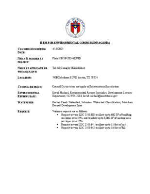
ITEM FOR ENVIRONMENTAL COMMISSION AGENDA COMMISSION MEETING DATE: 4/16/2025 NAME & NUMBER OF PROJECT: NAME OF APPLICANT OR ORGANIZATION: Flatz-130 SP-2024-0298D Ted McConaghy (Kleinfelder) LOCATION: 7400 Zekelman BLVD Austin, TX 78724 COUNCIL DISTRICT: Council District does not apply in Extraterritorial Jurisdiction ENVIRONMENTAL REVIEW STAFF: WATERSHED: David Michael, Environmental Review Specialist, Development Services Department, 512-974-2263, david.michael@ausitntexas.gov Decker Creek Watershed, Suburban Watershed Classification, Suburban Desired Development Zone. REQUEST: Variance requests are as follows: • Request to vary LDC 25-8-302 to allow up to 600 SF of building on slopes over 25%, and to allow up to 3,000 SF of parking area on slopes over 15%. • Request to vary LDC 25-8-341 to allow up to 11 feet of cut. • Request to vary LDC 25-8-342 to allow up to 16 feet of fill. Page 2 of 2 STAFF RECOMMENDATION: Staff recommends these variances, having determined the findings of fact to have been met. STAFF CONDITIONS: • All new 3:1 slopes will use the 609S upland seed mix with additional shrubs and trees provided near the base of the slopes to assist with stabilization. • The natural draw adjacent to buildings 3 and 7 is designed as a sunken garden that filters runoff with a trickle channel and pollinator plantings. • The site will meet full landscape requirements as specified by code despite the site being in the ETJ, where landscape ordinance do not apply. Notably, all parking spaces will be within 50 LF radius of a shade tree. Development Services Department Staff Recommendations Concerning Required Findings Project Name: Flatz-130 SP-2024-0298D Ordinance Standard: LDC Sec. 25-8-302 Variance Request: Request to vary LDC Sec. 25-8-302 to allow 600 SF of building on slopes over 25%, and to allow 3,000 SF of parking area to be located on slopes over 15%. A. Land Use Commission variance determinations from Chapter 25-8-41 of the City Code: 1. The requirement will deprive the applicant of a privilege available to owners of other similarly situated property with approximately contemporaneous development subject to similar code requirements; Yes. Not allowing the requested 600 SF of building area on slopes over 25%, and 3,000 SF of parking area on slopes over 15% will deprive the applicant of a privilege available to owners of other similarly situated property with approximately contemporaneous development subject to similar code requirements. This variance from code is necessary to integrate a typical multifamily housing development within a typical suburban watershed topography. The requested construction on slopes over 15% is due to steep drainage ‘rills’ bisecting the site. While such “rills” are not uncommon in suburban watersheds, they are spaced across this site in such a way that it is unreasonable to expect development of the site for multifamily housing without some degree of construction on slopes over 15%. 2. The variance: a. is not necessitated by the scale, layout, construction method, or other design decision made by the applicant, unless the design decision provides greater overall environmental protection than is achievable without the variance; Yes. The requested 600 SF of building located on slopes over 25%, and 3,000 SF of parking area located on slopes over 15% are not necessitated by a design decision. This variance from code is necessary to integrate a typical multifamily housing development within a typical suburban watershed topography; where slopes over 15% and slopes over 25% are found at drainage ‘rills’ bisecting sites such as this. Greater overall environmental protection is achieved with the additional landscape vegetation required as a condition of the variance. b. is the minimum deviation from the code requirement necessary to allow a reasonable use of the property; and Yes. The requested 600 SF of building located on slopes over 25%, and 3,000 SF of parking area located on slopes over 15% is the minimum deviation from the code requirement necessary to allow reasonable use of the property. The buildings and parking are situated atop the existing slopes, reasonably avoiding impacting drainage ‘rills’, minimizing the amount of building and parking on slopes. c. Does not create a significant probability of harmful environmental consequences; and Yes. The requested 600 SF of building located on slopes over 25%, and 3,000 SF of parking area located on slopes over 15% does not create a significant probability of harmful environmental consequences. This variance from code allows for the buildings and parking to be situated atop the existing slopes, avoiding impacts to the existing floodplain, CEF setbacks, and the inundation Zone, with the majority of existing slopes preserved. 3. Development with the variance will result in water quality that is at least equal to the water quality achievable without the variance. Yes. The requested 600 SF of building located on slopes over 25%, and 3,000 SF of parking area to be located on slopes over 15% will result in water quality that is at least equal to the water quality achievable without the variance. Landscape vegetation provided as a condition of the variance will result in water quality superior to what would be provided without the variance; the site will meet full landscape requirements as specified by code despite the site being located in the ETJ, where landscape ordinance do not apply. Notably, all parking spaces will be within 50 LF radius of a shade tree. The Land Use Commission may grant a variance from a requirement of Article 7, Division 1 ( Critical Water Quality Zone Restrictions ), after determining that: B. Additional Land Use Commission variance determinations for a requirement of Section 25- 8-422 (Water Quality Transition Zone), Section 25-8-452 (Water Quality Transition Zone), Section 25-8-482 (Water Quality Transition Zone), Section 25-8-652 (Restrictions on Development Impacting Lake Austin, Lady Bird Lake, and Lake Walter E. Long), or Article 7, Division 1 (Critical Water Quality Zone Restrictions): 1. The criteria for granting a variance in Subsection (A) are met; N/A 2. 3. The requirement for which a variance is requested prevents a reasonable, economic use of the entire property; N/A The variance is the minimum deviation from the code requirement necessary to allow a reasonable, economic use of the entire property. N/A Staff Determination: Staff determines that the findings of fact have been met. Staff recommends the following conditions: Environmental Review Specialist Senior (DSD) Environmental Policy Program Manager (DSD) Interim Environmental Officer (WPD) _____________________________ David Michael Date:________________ _____________________________ Mike McDougal Date ________________ _____________________________ Liz Johnston Date ________________ 3/31/20253/31/20254/11/2025 March 28, 2025 ENVIRONMENTAL COMMISSION VARIANCE APPLICATION FORM PROJECT DESCRIPTION Applicant Contact Information Name of Applicant Street Address City State ZIP Code Work Phone E-Mail Address Ted McConaghy (Kleinfelder) 7401-B Hwy. 71 W., Ste. 160 Austin, TX 78735 512-426-9326 tmcconaghy@kleinfelder.com Variance Case Information Case Name Case Number Address or Location Environmental Reviewer Name Environmental Resource Management Reviewer Name Applicable Ordinance Watershed Name Watershed Classification FLATZ-130 SP-2024-0298D 7400 Zekelman Blvd. David Michael Mike McDougal LDC Sec. 25-8-302 Decker Creek ☐Urban X Suburban ☐Water Supply Suburban ☐Water Supply Rural ☐ Barton Springs Zone City of Austin | Environmental Commission Variance Application Guide 1 March 28, 2025 Edwards Aquifer Recharge Zone ☐ Barton Springs Segment ☐ Northern Edwards Segment X Not in Edwards Aquifer Zones Edwards Aquifer Contributing Zone Distance to Nearest Classified Waterway ☐ Yes X No Old Decker Creek (within property boundaries) Water and Waste Water service to be provided by Austin Water Request LDC Sec. 25-8-302: Allow 600 SF of building to be located on slopes over 25%, and 3,000 SF of parking areas on slopes over 15%. Existing _____0___ _____0___ _____0___ Proposed 743,114 17.06 30.56 The 55.93-ac site includes Old Decker Creek (classified waterway) including a CWQZ and 100-yr fully developed floodplain. Topography is significant with primary slopes ranging from 5-10%, along with additional slopes over 25% along natural draws. There are a number of CEF’s (wetlands) along Old Decker Creek. The property is adjacent to FM 973, but Old Decker Creek lies between the FM 973 and the developable area. Crossing the CWQZ is required to take access to FM 973; to install a workable driveway/culvert system, the existing centerline of the creek will be relocated and the CWQZ will be relocated. Tree cover is extensive with mixed deciduous trees. Note; the site is in the ETJ and the landscape ordinance does not apply. Impervious cover square footage: acreage: percentage: Provide general description of the property (slope range, elevation range, summary of vegetation / trees, summary of the geology, CWQZ, WQTZ, CEFs, floodplain, heritage trees, any other notable or outstanding characteristics of the property) City of Austin | Environmental Commission Variance Application Guide 2 March 28, 2025 Clearly indicate in what way the proposed project does not comply with current Code (include maps and exhibits) FINDINGS OF FACT This variance is to allow the construction of 600 SF of building on slopes over 25%, and the construction of 3,000 SF of parking to be located on slopes over 15%. As required in LDC Section 25-8-41, in order to grant a variance the Land Use Commission must make the following findings of fact: Include an explanation with each applicable finding of fact. Project: Ordinance: A. Land Use Commission variance determinations from Chapter 25-8-41 of the City Code: 1. 2. The requirement will deprive the applicant of a privilege available to owners of similarly situated property with approximately contemporaneous development subject to similar code requirements. Yes. Many sites in the Austin area have areas of slopes over 15% and slopes over 25%; these are often in the form of drainage ‘rills’ that bisect sites as is the condition on this site. It is not practical to design sites around all areas of slopes. The variance: a) Is not necessitated by the scale, layout, construction method, or other design decision made by the applicant, unless the design decision provides greater overall environmental protection than is achievable without the variance; Yes. The existing drainage ‘rills’ with the associated slopes over 15% form an erodible surface that degrades the creek with sediment. The proposed development will stabilize the slopes and prevent sediment build-up in the creek. b) Is the minimum deviation from the code requirement necessary to allow a reasonable use of the property; City of Austin | Environmental Commission Variance Application Guide 3 March 28, 2025 Yes. The site improvements have been designed in a narrow footprint that considers the constraints of the existing floodplain, CEF setbacks, and the Inundation Zone. The majority of the existing slopes on the site have been preserved. c) Does not create a significant probability of harmful environmental consequences. Yes. The proposed development on slopes will stabilize the slopes behind compacted berms and will be routed to the stormwater management ponds; this will eliminate any harmful environmental consequences. 3. Development with the variance will result in water quality that is at least equal to the water quality achievable without the variance. Yes. Water quality ponds will capture all proposed site improvement areas which will equal that achievable without the variance. B. Additional Land Use Commission variance determinations for a requirement of Section 25-8-422 (Water Quality Transition Zone), Section 25-8-452 (Water Quality Transition Zone), Article 7, Division 1 (Critical Water Quality Zone Restrictions), or Section 25-8-368 (Restrictions on Development Impacting Lake Austin, Lady Bird Lake, and Lake Walter E. Long): 1. The criteria for granting a variance in Subsection (A) are met; N/A. 2. 3. The requirement for which a variance is requested prevents a reasonable, economic use of the entire property; N/A. The variance is the minimum deviation from the code requirement necessary to allow a reasonable, economic use of the entire property. N/A. **Variance approval requires all above affirmative findings. City of Austin | Environmental Commission Variance Application Guide 4 March 28, 2025 A Exhibits for Commission Variance o Aerial photos of the site o Site photos o Aerial photos of the vicinity o Context Map—A map illustrating the subject property in relation to developments in the vicinity to include nearby major streets and waterways o Topographic Map - A topographic map is recommended if a significant grade change on the subject site exists or if there is a significant difference in grade in relation to adjacent properties. o For cut/fill variances, a plan sheet showing areas and depth of cut/fill with topographic elevations. o Site plan showing existing conditions if development exists currently on the property o Proposed Site Plan- full size electronic or at least legible 11x17 showing proposed development, include tree survey if required as part of site or subdivision plan o Environmental Map – A map that shows pertinent features including Floodplain, CWQZ, WQTZ, CEFs, Setbacks, Recharge Zone, etc. o An Environmental Resource Inventory pursuant to ECM 1.3.0 (if required by 25-8-121) o Applicant’s variance request letter City of Austin | Environmental Commission Variance Application Guide 5 Development Services Department Staff Recommendations Concerning Required Findings Project Name: Flatz-130 SP-2024-0298D Ordinance Standard: LDC Sec. 25-8-341 Variance Request: Request to vary LDC Sec. 25-8-341 to allow up to 11’ of cut. A. Land Use Commission variance determinations from Chapter 25-8-41 of the City Code: 1. The requirement will deprive the applicant of a privilege available to owners of other similarly situated property with approximately contemporaneous development subject to similar code requirements; Yes. Other owners with similarly situate properties and contemporaneous development have received similar variances for grading. Turner's Crossing (C8J-2018-0091) with cut and fill to 15 feet, Northwind Apartments (SP-2021-0384C.SH) with cut to 12 and fill to 17 feet, and Blueridge Multifamily at Wildhorse Ranch (SP-2022- 0426C.SH) with cut to 12 and fill to 10 feet, are all residential projects on sites with rolling topography generally within the 0-15% slope category. All of these sites were granted variances to exceed the Chapter 25-8 limit for cut and fill. 2. The variance: a. is not necessitated by the scale, layout, construction method, or other design decision made by the applicant, unless the design decision provides greater overall environmental protection than is achievable without the variance; Yes. The requested cut up to 11 feet is not necessitated by a design decision. This variance from code is necessary because the location of vehicular entrance to the site is has been set TxDOT on FM 973, which channels the primary access road into irregular topography that is requires up to 11 feet of cut to reasonably negotiate for the purpose of providing typical grades for a primary drive of a multifamily development in a suburban watershed. b. is the minimum deviation from the code requirement necessary to allow a reasonable use of the property; and Yes. The requested cut of up to 11 feet is the minimum deviation from the code requirement is necessary to allow reasonable use of the property. TxDOT requires the driveway location for the project at a specific location on FM 973, and the requested 11 feet of cut allows for a reasonable solution to the problem of providing an entrance drive at that specific driveway location. c. Does not create a significant probability of harmful environmental consequences; and Yes. The requested cut up to 11 feet does not create a significant probability of harmful environmental consequences. This variance from code is limited to a few areas beneath, and adjacent to, the entrance drive, with no impact to the larger site. 3. Development with the variance will result in water quality that is at least equal to the water quality achievable without the variance. Yes. The requested cut up to 11 feet will result in water quality that is at least equal to the water quality achievable without the variance. Landscape vegetation provided as a condition of the variance will result in water quality superior to what would be provided without the variance; all new 3:1 slopes will use the 609S upland seed mix with additional shrubs and trees provided near the base of the slopes to assist with stabilization. The Land Use Commission may grant a variance from a requirement of Article 7, Division 1 ( Critical Water Quality Zone Restrictions ), after determining that: B. Additional Land Use Commission variance determinations for a requirement of Section 25- 8-422 (Water Quality Transition Zone), Section 25-8-452 (Water Quality Transition Zone), Section 25-8-482 (Water Quality Transition Zone), Section 25-8-652 (Restrictions on Development Impacting Lake Austin, Lady Bird Lake, and Lake Walter E. Long), or Article 7, Division 1 (Critical Water Quality Zone Restrictions): 1. The criteria for granting a variance in Subsection (A) are met; N/A 2. 3. The requirement for which a variance is requested prevents a reasonable, economic use of the entire property; N/A The variance is the minimum deviation from the code requirement necessary to allow a reasonable, economic use of the entire property. N/A Staff Determination: Staff determines that the findings of fact have been met. Staff recommends the following conditions: Environmental Review Specialist Senior (DSD) Environmental Policy Program Manager (DSD) Interim Environmental Officer (WPD) _____________________________ David Michael Date:________________ _____________________________ Mike McDougal Date ________________ _____________________________ Liz Johnston Date ________________ 3/31/20253/31/20254/11/2025 March 27, 2025 ENVIRONMENTAL COMMISSION VARIANCE APPLICATION FORM PROJECT DESCRIPTION Applicant Contact Information Name of Applicant Street Address City State ZIP Code Work Phone E-Mail Address Ted McConaghy (Kleinfelder) 7401-B Hwy. 71 W., Ste. 160 Austin, TX 78735 512-426-9326 tmcconaghy@kleinfelder.com Variance Case Information Case Name Case Number Address or Location Environmental Reviewer Name Environmental Resource Management Reviewer Name Applicable Ordinance FLATZ-130 SP-2024-0298D 7400 Zekelman Blvd. David Michael Mike McDougal LDC Sec. 25-8-341 (11 feet) Watershed Name Decker Creek Watershed Classification ☐Urban X Suburban ☐Water Supply Suburban ☐Water Supply Rural ☐ Barton Springs Zone City of Austin | Environmental Commission Variance Application Guide 1 March 27, 2025 Edwards Aquifer Recharge Zone ☐ Barton Springs Segment ☐ Northern Edwards Segment X Not in Edwards Aquifer Zones Edwards Aquifer Contributing Zone Distance to Nearest Classified Waterway ☐ Yes X No On classified waterway (Old Decker Creek) Water and Waste Water service to be provided by Austin Water Request The variance request is as follows: Cut up to 11’. City of Austin LDC Sec. 25-8-341. Existing _____0___ _____0___ _____0___ Proposed 743,114 17.06 30.56 The 55.83-ac site includes Old Decker Creek (classified waterway) including a CWQZ and 100-yr fully developed floodplain. Topography is significant with primary slopes ranging from 5-10%, along with additional slopes over 25% along natural draws. There are a number of CEF’s (wetlands) along Old Decker Creek. The property is adjacent to FM 973, but Old Decker Creek lies between the FM 973 and the developable area. Crossing the CWQZ is required to take access to FM 973. Tree cover is extensive with mixed deciduous trees. Note; the site is in the ETJ and the landscape ordinance does not apply. Impervious cover square footage: acreage: percentage: Provide general description of the property (slope range, elevation range, summary of vegetation / trees, summary of the geology, CWQZ, WQTZ, CEFs, floodplain, heritage trees, any other notable or outstanding characteristics of the property) City of Austin | Environmental Commission Variance Application Guide 2 March 27, 2025 Clearly indicate in what way the proposed project does not comply with current Code (include maps and exhibits) FINDINGS OF FACT This variance is for allowing Cut up to 11’ as shown on the Proposed Variance exhibit. LDC Sec. 25-8-341 As required in LDC Section 25-8-41, in order to grant a variance the Land Use Commission must make the following findings of fact: Include an explanation with each applicable finding of fact. Project: Ordinance: A. Land Use Commission variance determinations from Chapter 25-8-41 of the City Code: 1. 2. The requirement will deprive the applicant of a privilege available to owners of similarly situated property with approximately contemporaneous development subject to similar code requirements. Yes. Cut up to 11’ is routinely granted for properties with similar topographic conditions and related restrictions such as adjacent creeks, CEF buffers, etc. The variance: a) Is not necessitated by the scale, layout, construction method, or other design decision made by the applicant, unless the design decision provides greater overall environmental protection than is achievable without the variance; Yes. All areas of cut over 8’ will be within stabilized areas and will not result in any environmental degradation. Cut has been minimized to the greatest extent possible, and is only required due to the severe site topography and the location of the primary access drive. The driveway connection to N. FM 973 is set by TxDOT; this determines the alignment of the access drive, which correlates to the location of the areas of cut over 8’. City of Austin | Environmental Commission Variance Application Guide 3 March 27, 2025 b) Is the minimum deviation from the code requirement necessary to allow a reasonable use of the property; Yes. The site has been designed to minimize cut to the greatest degree possible, while providing the required primary north – south access drive with the appropriate driveway connection to N. FM 973. c) Does not create a significant probability of harmful environmental consequences. Yes. All areas of cut up to 11’ are under pavement or similarly stabilized; there is no risk of increased erosion or other harmful environmental consequences. 3. Development with the variance will result in water quality that is at least equal to the water quality achievable without the variance. Yes. The water quality of the site will be unaffected by developing with the variance. B. Additional Land Use Commission variance determinations for a requirement of Section 25-8-422 (Water Quality Transition Zone), Section 25-8-452 (Water Quality Transition Zone), Article 7, Division 1 (Critical Water Quality Zone Restrictions), or Section 25-8-368 (Restrictions on Development Impacting Lake Austin, Lady Bird Lake, and Lake Walter E. Long): 1. The criteria for granting a variance in Subsection (A) are met; N/A 2. 3. The requirement for which a variance is requested prevents a reasonable, economic use of the entire property; N/A The variance is the minimum deviation from the code requirement necessary to allow a reasonable, economic use of the entire property. N/A **Variance approval requires all above affirmative findings. City of Austin | Environmental Commission Variance Application Guide 4 March 27, 2025 A Exhibits for Commission Variance o Aerial photos of the site o Site photos o Aerial photos of the vicinity o Context Map—A map illustrating the subject property in relation to developments in the vicinity to include nearby major streets and waterways o Topographic Map - A topographic map is recommended if a significant grade change on the subject site exists or if there is a significant difference in grade in relation to adjacent properties. o For cut/fill variances, a plan sheet showing areas and depth of cut/fill with topographic elevations. o Site plan showing existing conditions if development exists currently on the property o Proposed Site Plan- full size electronic or at least legible 11x17 showing proposed development, include tree survey if required as part of site or subdivision plan o Environmental Map – A map that shows pertinent features including Floodplain, CWQZ, WQTZ, CEFs, Setbacks, Recharge Zone, etc. o An Environmental Resource Inventory pursuant to ECM 1.3.0 (if required by 25-8-121) o Applicant’s variance request letter City of Austin | Environmental Commission Variance Application Guide 5 Development Services Department Staff Recommendations Concerning Required Findings Project Name: Flatz-130 SP-2024-0298D Ordinance Standard: LDC Sec. 25-8-342 Variance Request: Request to vary LDC Sec. 25-8-342 to allow up to 16’ of fill, and construct a water quality control facility over 4’ on slopes with a gradient of more than 15%. A. Land Use Commission variance determinations from Chapter 25-8-41 of the City Code: 1. The requirement will deprive the applicant of a privilege available to owners of other similarly situated property with approximately contemporaneous development subject to similar code requirements; Yes. Not allowing the requested fill up to 16 feet, and the water quality control facility constructed on slopes over 4 feet with a gradient of more than 15%, will deprive the applicant of a privilege available to owners of other similarly situated property with approximately contemporaneous development subject to similar code requirements. Other owners with similarly situate properties and contemporaneous development have received similar variances for grading. Turner's Crossing (C8J-2018-0091) with cut and fill to 15 feet, Northwind Apartments (SP-2021-0384C.SH) with cut to 12 and fill to 17 feet, and Blueridge Multifamily at Wildhorse Ranch (SP-2022- 0426C.SH) with cut to 12 and fill to 10 feet, are all residential projects on sites with rolling topography generally within the 0-15% slope category. All of these sites were granted variances to exceed the Chapter 25-8 limit for cut and fill. 2. The variance: a. is not necessitated by the scale, layout, construction method, or other design decision made by the applicant, unless the design decision provides greater overall environmental protection than is achievable without the variance; Yes. The requested fill up to 16 feet, and the water quality control facility constructed on slopes over 4 with a gradient of more than 15%, are not necessitated by the scale, layout, construction method, or other design decision made by the applicant. the design decision provides greater overall environmental protection than is achievable without the variance. The fill is required to negotiate several minor draws that bisect the site that cannot be avoided, given that the buildable area is boxed in by the driveway location (determined by TxDot) to the east, and the Critical Water Quality Zone, Floodplain, and Erosion Hazard Zones to the north and west. b. is the minimum deviation from the code requirement necessary to allow a reasonable use of the property; and Yes. The requested fill up to 16 feet, and the water quality control facility constructed on slopes over 4 feet with a gradient of more than 15%, are the minimum deviation from the code requirement necessary to allow a reasonable use of the property. The fill up to 16 feet is the least amount needed to provide reasonable vehicular access to the residential buildings, and is limited to an area along a single natural draw. The water quality control facility is constructed on slopes over 4 feet with a gradient of more than 15% to efficiently integrates City of Austin requirements for water quality and detention into the existing topography. c. Does not create a significant probability of harmful environmental consequences; and Yes. The requested fill up to 16 feet, and the water quality control facility constructed on slopes over 4 feet with a gradient of more than 15%, do not create a significant probability of harmful environmental consequences. This variance from code uses compacted berms to stabilize the slopes created by the fill up to 16 feet, and route runoff to the stormwater management ponds; preventing erosion and allowing absorption of rainfall on site. Landscape vegetation provided as a condition of the variance will result in water quality superior to what would be provided without the variance. 3. Development with the variance will result in water quality that is at least equal to the water quality achievable without the variance. Yes. The requested fill up to 16 feet, and the water quality control facility constructed on slopes over 4 feet with a gradient of more than 15%, will result in water quality that is at least equal to the water quality achievable without the variance. Landscape vegetation provided as a condition of the variance will result in water quality superior to what would be provided without the variance; the primary draw adjacent to the buildings is designed as a sunken garden that filters runoff with a trickle channel and pollinator plantings. The Land Use Commission may grant a variance from a requirement of Article 7, Division 1 ( Critical Water Quality Zone Restrictions ), after determining that: B. Additional Land Use Commission variance determinations for a requirement of Section 25- 8-422 (Water Quality Transition Zone), Section 25-8-452 (Water Quality Transition Zone), Section 25-8-482 (Water Quality Transition Zone), Section 25-8-652 (Restrictions on Development Impacting Lake Austin, Lady Bird Lake, and Lake Walter E. Long), or Article 7, Division 1 (Critical Water Quality Zone Restrictions): 1. The criteria for granting a variance in Subsection (A) are met; N/A 2. 3. The requirement for which a variance is requested prevents a reasonable, economic use of the entire property; N/A The variance is the minimum deviation from the code requirement necessary to allow a reasonable, economic use of the entire property. N/A Staff Determination: Staff determines that the findings of fact have been met. Staff recommends the following conditions: Environmental Review Specialist Senior (DSD) Environmental Policy Program Manager (DSD) Interim Environmental Officer (WPD) _____________________________ David Michael Date:________________ _____________________________ Mike McDougal Date ________________ _____________________________ Liz Johnston Date ________________ 3/31/20253/31/20254/11/2025 March 27, 2025 ENVIRONMENTAL COMMISSION VARIANCE APPLICATION FORM PROJECT DESCRIPTION Applicant Contact Information Name of Applicant Street Address City State ZIP Code Work Phone E-Mail Address Ted McConaghy (Kleinfelder) 7401-B Hwy. 71 W., Ste. 160 Austin, TX 78735 512-426-9326 tmcconaghy@kleinfelder.com Variance Case Information Case Name Case Number Address or Location Environmental Reviewer Name Environmental Resource Management Reviewer Name Applicable Ordinance FLATZ-130 SP-2024-0298D 7400 Zekelman Blvd. David Michael Mike McDougal LDC Sec. 25-8-342, Fill up to 16’ Watershed Name Decker Creek Watershed Classification ☐Urban X Suburban ☐Water Supply Suburban ☐Water Supply Rural ☐ Barton Springs Zone City of Austin | Environmental Commission Variance Application Guide 1 March 27, 2025 Edwards Aquifer Recharge Zone ☐ Barton Springs Segment ☐ Northern Edwards Segment X Not in Edwards Aquifer Zones Edwards Aquifer Contributing Zone Distance to Nearest Classified Waterway ☐ Yes X No On classified waterway (Old Decker Creek) Water and Waste Water service to be provided by Austin Water Request The variance request is as follows: Fill up to 16’, and construction of a water quality facility with over 4’ of fill on slopes over 15%. City of Austin LDC Sec. 25-8-342 Existing _____0___ _____0___ _____0___ Proposed 743,114 17.06 30.56 The 55.83-ac site includes Old Decker Creek (classified waterway) including a CWQZ and 100-yr fully developed floodplain. Topography is significant with primary slopes ranging from 5-10%, along with additional slopes over 25% along natural draws. There are a number of CEF’s (wetlands) along Old Decker Creek. The property is adjacent to FM 973, but Old Decker Creek lies between the FM 973 and the developable area. Crossing the CWQZ is required to take access to FM 973. Tree cover is extensive with mixed deciduous trees. Note; the site is in the ETJ and the landscape ordinance does not apply. Impervious cover square footage: acreage: percentage: Provide general description of the property (slope range, elevation range, summary of vegetation / trees, summary of the geology, CWQZ, WQTZ, CEFs, floodplain, heritage trees, any other notable or outstanding characteristics of the property) City of Austin | Environmental Commission Variance Application Guide 2 March 27, 2025 Clearly indicate in what way the proposed project does not comply with current Code (include maps and exhibits) FINDINGS OF FACT This variance is to allow Fill up to 16’, and construction of a water quality facility with more than 4’ of fill on slopes over 15%, as shown on the Proposed Variance and Proposed Slope Map exhibits. LDC Sec. 25-8-342 As required in LDC Section 25-8-41, in order to grant a variance the Land Use Commission must make the following findings of fact: Include an explanation with each applicable finding of fact. Project: Ordinance: A. Land Use Commission variance determinations from Chapter 25-8-41 of the City Code: 1. 2. The requirement will deprive the applicant of a privilege available to owners of similarly situated property with approximately contemporaneous development subject to similar code requirements. Yes. Fill up to 16’ is routinely granted for properties with similar topographic conditions and related restrictions such as adjacent creeks, CEF buffers, etc. The variance: a) Is not necessitated by the scale, layout, construction method, or other design decision made by the applicant, unless the design decision provides greater overall environmental protection than is achievable without the variance; Yes. All areas of Fill up to 16’ will be within stabilized areas and will not result in any environmental degradation. Fill up to 16’ has been minimized to the greatest extent possible, and is only required due to the severe site topography and the need to avoid encroachment into the Inundation Zone. As shown on the Existing Slope Map exhibit, there are several minor ‘draws’ that run east- west and bisect the developable portion of the site; these areas require the majority of the Fill up to 16’. The proposed developed area has been designed City of Austin | Environmental Commission Variance Application Guide 3 March 27, 2025 to increase density away from the creek while leaving the creek and surrounding areas undisturbed. There are two ponds (Ponds A and B) in the southwest corner of the site that require fill over 4’ on existing slopes over 15%. The ponds have been carefully located to avoid encroaching into the CEF-wetland buffer areas, but construction on existing slopes over 15% could not be avoided. b) Is the minimum deviation from the code requirement necessary to allow a reasonable use of the property; Yes. The site has been designed to minimize Fill to the greatest degree possible, but is necessary to provide safe access roads to the residential buildings. Most of the significant fill (over 12’) is limited to a single natural draw located adjacent to buildings 3 and 7 at the location of a primary access drive. The ponds are necessary to meet standard City of Austin requirements for water quality and detention. c) Does not create a significant probability of harmful environmental consequences. Yes. All areas of Fill up to 16’ are under pavement or similarly stabilized; there is no risk of increased erosion or other harmful environmental consequences. The ponds are stabilized with either structural walls or earthen berms. 3. Development with the variance will result in water quality that is at least equal to the water quality achievable without the variance. Yes. The water quality of the site will be unaffected by developing with the variance. B. Additional Land Use Commission variance determinations for a requirement of Section 25-8-422 (Water Quality Transition Zone), Section 25-8-452 (Water Quality Transition Zone), Article 7, Division 1 (Critical Water Quality Zone Restrictions), or Section 25-8-368 (Restrictions on Development Impacting Lake Austin, Lady Bird Lake, and Lake Walter E. Long): 1. The criteria for granting a variance in Subsection (A) are met; N/A 2. The requirement for which a variance is requested prevents a reasonable, economic use of the entire property; N/A City of Austin | Environmental Commission Variance Application Guide 4 March 27, 2025 3. The variance is the minimum deviation from the code requirement necessary to allow a reasonable, economic use of the entire property. N/A **Variance approval requires all above affirmative findings. City of Austin | Environmental Commission Variance Application Guide 5 March 27, 2025 A Exhibits for Commission Variance o Aerial photos of the site o Site photos o Aerial photos of the vicinity o Context Map—A map illustrating the subject property in relation to developments in the vicinity to include nearby major streets and waterways o Topographic Map - A topographic map is recommended if a significant grade change on the subject site exists or if there is a significant difference in grade in relation to adjacent properties. o For cut/fill variances, a plan sheet showing areas and depth of cut/fill with topographic elevations. o Site plan showing existing conditions if development exists currently on the property o Proposed Site Plan- full size electronic or at least legible 11x17 showing proposed development, include tree survey if required as part of site or subdivision plan o Environmental Map – A map that shows pertinent features including Floodplain, CWQZ, WQTZ, CEFs, Setbacks, Recharge Zone, etc. o An Environmental Resource Inventory pursuant to ECM 1.3.0 (if required by 25-8-121) o Applicant’s variance request letter City of Austin | Environmental Commission Variance Application Guide 6