20250205-004: Taylor Slough Dredge Maintenance Variance Packet — original pdf
Backup
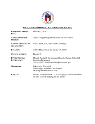
ITEM FOR ENVIRONMENTAL COMMISSION AGENDA February 5, 2025 Taylor Slough Dredge Maintenance, SP-2024-0019D Janis J. Smith, P.E., Janis Smith Consulting COMMISSION MEETING DATE: NAME & NUMBER OF PROJECT: NAME OF APPLICANT OR ORGANIZATION: LOCATION: 3704 ½ Meadowbank Dr, Austin, TX, 78703 COUNCIL DISTRICT: District 10 ENVIRONMENTAL REVIEW STAFF: WATERSHED: Miranda Reinhard, Environmental Scientist Senior, Watershed Protection Department 512-978-1537, miranda.reinhard@austintexas.gov Lake Austin Watershed Water Supply Suburban Classification Drinking Water Protection Zone REQUEST: Request to vary from LDC 25-8-261(C)(9)(a) to allow more than 25 cubic yards of dredging in Lake Austin. Page 2 of 2 STAFF RECOMMENDATION: Staff recommends this variance, having determined the findings of fact to have been met. STAFF CONDITIONS: Staff recommends the following conditions: 1. Provide required wetland mitigation plantings (1,236 plantings comprised of 9 different species of FAC, FACW, and OBL species) along the shoreline. 2. Provide bulkhead mitigation plantings (29 plantings comprised of 3 different species of FACW and OBL species) along the shoreline. 3. Restore all areas disturbed in the Critical Water Quality Zone (CWQZ) per Standard Specification 609S. 4. Limit dredging outside of the 50% Critical Root Zones (CRZ) of trees along the shoreline and install tree boards fencing. 5. Provide measures to minimize/avoid sediment discharge including: 1) stabilized construction entrance and access road from the Meadowbank Drive entrance to the barge access location and, 2) mulch sock around the entire limits of construction (LOC) of the staging, storage and dewatering areas, and 3) two rock berms downstream of the staging, storage, and dewatering areas, and 4) stabilized dewatering area for dredge bags, and 5) floating turbidity curtain downstream of the dewatering operation, and 6) floating turbidity curtain surrounding active dredge area. 6. Conduct dredging via hydraulic methods including bagging of material. Watershed Protection Department Staff Recommendations Concerning Required Findings Taylor Slough Dredge Maintenance, SP-2024-0019D Project Name: Ordinance Standard: Current Code Variance Request: Request to vary from LDC 25-8-261(C)(9)(a) to allow more than 25 cubic yards of dredging in Lake Austin. A. Land Use Commission variance determinations from Chapter 25-8-41 of the City Code: 1. The requirement will deprive the applicant of a privilege available to owners of other similarly situated property with approximately contemporaneous development subject to similar code requirements; b. The project proposes to Taylor Slough, which is part of Lake Austin, to provide navigation Yes access for the homeowners due to years of sediment build-up in the waterway and a bulkhead modification along the shoreline downstream of the proposed staging area. A “similarly situated property with approximate contemporaneous development subject to similar code requirements” is 4301 & 4307 Michael’s Cove (SP-2010-0005D). This project was approved in 2010 to dredge down to an elevation of 489’ and removed approximately 5,000 cubic yards (CY) of dredge in a lagoon/cove connected to Lake Austin. Another “similarly situated property with approximately contemporaneous development subject to similar code requirements” is Taylor Slough Silt Removal Project (SP-93-0380D). This project was approved in 1993 to dredge down to an elevation of 488.3’ and removed approximately 2,500 CY of dredge within the same waterway connected to Lake Austin. LDC 25-8-261(C)(9)(a) allows up to 25 cubic yards of dredging in the lake for navigation safety for a single site plan permit application. The current variance application proposes to dredge down to an elevation of 489.2’ and remove 1,771.3 CY of dredge. This project proposes a similar depth of dredge to the previous projects mentioned above and has a smaller volume of dredge. Is not based on a condition caused by the method chosen by the applicant to develop the property, unless the development method provides greater overall environmental protection than is achievable without the variance; Yes for the homeowners with shoreline access to the waterway. Approval of a smaller dredge volume may result in more frequent dredging requests and the risk of harmful environmental impacts. Is the minimum change necessary to avoid the deprivation of a privilege given to other property owners and to allow a reasonable use of the property; and The amount of dredge requested is the minimum amount needed to restore navigable depth Yes with the construction of a double-slip dock. The amount of dredge requested is the minimum amount The code allows up to 25 CY of dredge for navigation safety. This is typically associated 2. The variance: a. needed to restore navigable depth to provide the homeowners with access to shoreline frontage via nautical traffic. Approval of a smaller dredge volume may result in more frequent dredging requests and the risk of harmful environmental impacts. c. Does not create a significant probability of harmful environmental consequences; and This project does not create a significant probability of harmful environmental Yes consequences. This project will reduce the disturbance of sediment due to nautical traffic which can negatively affect the water quality of the waterway. Barge access for loading and unloading of equipment and materials will occur from Lake Austin. Measures to minimize/avoid sediment discharge include: 1) stabilized construction entrance and access road from the Meadowbank Drive entrance to the barge access location and, 2) mulch sock around the entire limits of construction (LOC) of the staging, storage and dewatering areas, and 3) two rock berms downstream of the staging, storage, and dewatering areas, and 4) stabilized dewatering area for dredge bags, and 5) floating turbidity curtain downstream of the dewatering operation, and 6) floating turbidity curtain surrounding active dredge area. This project will conduct dredging via hydraulic methods including bagging of material. This project will provide required wetland mitigation plantings (1,236 plantings comprised of 9 different species of FAC, FACW, and OBL species) and bulkhead mitigation plantings (29 plantings comprised of 3 different species of FACW and OBL species) along the shoreline. This project will also restore all areas disturbed in the Critical Water Quality Zone (CWQZ) per Standard Specification 609S. Dredging is limited to outside of the 50% Critical Root Zones (CRZ) of trees along the shoreline and tree fencing will be installed. The amount of dredge requested is the minimum amount needed to restore navigable depth for the homeowners with shoreline access to the waterway. Approval of a smaller dredge volume may result in more frequent dredging requests and the risk of harmful environmental impacts. This methodology provides less frequent disturbance of sediment, the lake ecosystem, and the shoreline vegetation/wetland Critical Environmental Features (CEFs). 3. Development with the variance will result in water quality that is at least equal to the water quality achievable This project will result in equal to or improved water quality. Dredging the site is necessary without the variance. Yes to protect the water quality of the lake by eliminating the churning of the lakebed by boat traffic which leads to sediment-laden lake water. This project will provide required wetland mitigation plantings (1,236 plantings comprised of 9 different species of FAC, FACW, and OBL species) and bulkhead mitigation plantings (29 plantings comprised of 3 different species of FACW and OBL species) along the shoreline. The Land Use Commission may grant a variance from a requirement of Article 7, Division 1 (Waterway and B. Floodplain Protection), after determining that: Additional Land Use Commission variance determinations for a requirement of Article 7, Division 1 (Waterway and Floodplain Protection): 1. The criteria for granting a variance in Subsection (A) are met; Yes sufficient shoreline access while minimizing environmental impacts. The criteria for granting the variance are met. The project will allow homeowners to have 2. The requirement for which a variance is requested prevents a reasonable, economic use of the entire property; Yes Due to the channel’s inaccessibility, the dredging is requested to guarantee the homeowner’s shoreline access. After years of sediment build-up in the waterway, the amount of dredge requested is 3. the minimum amount needed to restore navigable depth to provide the homeowners with legally guaranteed access to shoreline frontage via nautical traffic. Approval of a smaller dredge volume may result in more frequent dredging requests and the risk of harmful environmental impacts. The variance is the minimum deviation from the code requirement necessary to allow a reasonable, economic use of the entire property. Yes navigable depth for homeowners with shoreline access to the waterway. Approval of a smaller dredge volume may result in more frequent dredging requests and the risk of harmful environmental impacts. The dredge amount requested is the minimum amount needed to restore the waterway to a Staff Determination: Staff determines that the findings of fact have been met. Staff recommends the following conditions: 1. Provide required wetland mitigation plantings (1,236 plantings comprised of 9 different species of FAC, 2. Provide bulkhead mitigation plantings (29 plantings comprised of 3 different species of FACW and OBL FACW, and OBL species) along the shoreline. species) along the shoreline. 3. Restore all areas disturbed in the Critical Water Quality Zone (CWQZ) per Standard Specification 609S. 4. Limit dredging to outside of the 50% Critical Root Zones (CRZ) of trees along the shoreline and install tree fencing. 5. Provide measures to minimize/avoid sediment discharge including: 1) stabilized construction entrance and access road from the Meadowbank Drive entrance to the barge access location and, 2) mulch sock around the entire limits of construction (LOC) of the staging, storage and dewatering areas, and 3) two rock berms downstream of the staging, storage, and dewatering areas, and 4) stabilized dewatering area for dredge bags, and 5) floating turbidity curtain downstream of the dewatering operation, and 6) floating turbidity curtain surrounding active dredge area. 6. Conduct dredging via hydraulic methods including bagging of material. Wetland Biologist (WPD) Environmental Conservation Program Manager (WPD) Interim Environmental Officer (WPD) ____________________________ Miranda Reinhard ____________________________ John Clement Date 1/29/2025 Date 1/29/2025 ____________________________ Liz Johnston Date 1/29/2025 This permit specifies 1771.3 CY of dredge to restore navigability to the slough. Current code allows 25 CY of dredge for a site plan permit. July 25, 2024 Clearly indicate in what way the proposed project does not comply with current Code (include maps and exhibits) FINDINGS OF FACT Project: Ordinance: 1. 2. As required in LDC Section 25-8-41, in order to grant a variance the Land Use Commission must make the following findings of fact: Include an explanation with each applicable finding of fact. A. Land Use Commission variance determinations from Chapter 25-8-41 of the City Code: The requirement will deprive the applicant of a privilege available to owners of similarly situated property with approximately contemporaneous development subject to similar code requirements. Yes / No [provide summary of justification for determination] See Attachment 4, Findings of Fact The variance: a) Is not necessitated by the scale, layout, construction method, or other design decision made by the applicant, unless the design decision provides greater overall environmental protection than is achievable without the variance; Yes / No See Attachment 4, Findings of Fact [provide summary of justification for determination] Is the minimum deviation from the code requirement necessary to allow a reasonable use of the property; Yes / No See Attachment 4, Findings of Fact [provide summary justification for determination] Does not create a significant probability of harmful environmental consequences. b) c) Yes / No See Attachment 4, Findings of Fact [provide summary justification for determination] City of Austin | Environmental Commission Variance Application Guide 3 July 25, 2024 3. Development with the variance will result in water quality that is at least equal to the water quality achievable without the variance. Yes / No [provide summary justification for determination] See Attachment 4, Findings of Fact B. Additional Land Use Commission variance determinations for a requirement of Section 25-8-422 (Water Quality Transition Zone), Section 25-8-452 (Water Quality Transition Zone), Article 7, Division 1 (Critical Water Quality Zone Restrictions), or Section 25-8-652 (Development Impacting Lake Austin, Lady Bird Lake, and Lake Walter E. Long): 1. The criteria for granting a variance in Subsection (A) are met; Yes / No [provide summary of justification for determination] See Attachment 4, Findings of Fact The requirement for which a variance is requested prevents a reasonable, economic use of the entire property; Yes / No [provide summary of justification for determination] See Attachment 4, Findings of Fact The variance is the minimum deviation from the code requirement necessary to allow a reasonable, economic use of the entire property. 2. 3. Yes / No [provide summary of justification for determination] See Attachment 4, Findings of Fact **Variance approval requires all above affirmative findings. City of Austin | Environmental Commission Variance Application Guide 4 July 25, 2024 A Exhibits for Commission Variance o Aerial photos of the site o Site photos o Aerial photos of the vicinity o Context Map—A map illustrating the subject property in relation to developments in the vicinity to include nearby major streets and waterways o Topographic Map - A topographic map is recommended if a significant grade change on the subject site exists or if there is a significant difference in grade in relation to adjacent properties. o For cut/fill variances, a plan sheet showing areas and depth of cut/fill with topographic elevations. o Site plan showing existing conditions if development exists currently on the property o Proposed Site Plan- full size electronic or at least legible 11x17 showing proposed development, include tree survey if required as part of site or subdivision plan o Environmental Map – A map that shows pertinent features including Floodplain, CWQZ, WQTZ, CEFs, Setbacks, Recharge Zone, etc. o An Environmental Resource Inventory pursuant to ECM 1.3.0 (if required by 25-8-121) o Applicant’s variance request letter City of Austin | Environmental Commission Variance Application Guide 5 ATTACHMENT 1 OVERALL PROJECT AREA Ill All Aerials < 1940 Aerials 2023 Aerials I 1111111111 I 111111 J � 2019 ATTACHMENT 2 SP-93-0380D ATTACHMENT 3 SP-2024-0019D APPENDIX P-1 - EROSION CONTROL NOTES 1. The contractor shall install erosion/sedimentation controls and tree/natural area protective fencing prior to any site preparation work (clearing, grubbing or excavation). 2. The placement of erosion/sedimentation controls shall be in accordance with the Environmental Criteria Manual and the approved Erosion and Sedimentation Control Plan. The COA ESC Plan shall be consulted and used as the basis for a TPDES required SWPPP. If a SWPPP is required, it shall be available for review by the City of Austin Environmental Inspector at all times during construction, including at the Pre-Construction meeting. The checklist below contains the basic elements that shall be reviewed for permit approval by COA EV Plan Reviewers as well as COA EV Inspectors. — Plan sheets submitted to the City of Austin MUST show the following: ✓ Direction of flow during grading operations. ✓ Location, description, and calculations for off-site flow diversion structures. ✓ Areas that will not be disturbed; natural features to be preserved. ✓ Delineation of contributing drainage area to each proposed BMP (e.g., silt fence, sediment basin, etc.) ✓ Location and type of E&S BMPs for each phase of disturbance. ✓ Calculations for BMPs as required. ✓ Location and description of temporary stabilization measures. ✓ Location of on-site spoils, description of handling and disposal of borrow materials, and description of on-site permanent spoils disposal areas, including size, depth of fill and revegetation procedures. Installation sequence of controls (e.g. perimeter controls, then sediment basins, then temporary stabilization, then permanent, etc.) ✓ Describe sequence of construction as it pertains to ESC including the following elements: 1. 2. Project phasing if required (LOC greater than 25 acres) 3. Sequence of grading operations and notation of temporary stabilization measures to be used 4. Schedule for converting temporary basins to permanent WQ controls 5. Schedule for removal of temporary controls 6. Anticipated maintenance schedule for temporary controls — Categorize each BMP under one of the following areas of BMP activity as described below: 3.1 Minimize disturbed area and protect natural features and soil 3.2 Control Stormwater flowing onto and through the project 3.3 Stabilize Soils 3.4 Protect Slopes 3.5 Protect Storm Drain Inlets 3.6 Establish Perimeter Controls and Sediment Barriers 3.7 Retain Sediment On-Site and Control Dewatering Practices 3.8 Establish Stabilized Construction Exits 3.9 Any Additional BMPs — Note the location of each BMP on your site map(s). — For any structural BMPs, you should provide design specifications and details and refer to them. — For more information, see City of Austin Environmental Criteria Manual 1.4. 3. The Placement of tree/natural area protective fencing shall be in accordance with the City of Austin standard Notes for Tree and Natural Area Protection and the approved Grading/Tree and Natural Area Plan. 4. A pre-construction conference shall be held on-site with the contractor, design Engineer/permit applicant and Environmental Inspector after installation of the erosion/sedimentation controls and tree/natural area protection measures and prior to beginning any site preparation work. The owner or owner's representative shall notify the Planning and Development Review Department, 974-2278, at least three days prior to the meeting date. COA approved ESC Plan and TPDES SWPPP (if required) should be reviewed by COA EV Inspector at this time. 5. Any major variation in materials or locations of controls or fences from those shown on the approved plans will require a revision and must be approved by the reviewing Engineer, Environmental Specialist or City Arborist as appropriate. Major revisions must be approved by authorized COA staff. Minor changes to be made as field revisions to the Erosion and Sedimentation Control Plan may be required by the Environmental Inspector during the course of construction to correct control inadequacies. 6. The contractor is required to provide a certified inspector with either a Certified Professional in Erosion and Sediment Control (CPESC), Certified Erosion, Sediment and Stormwater- Inspector (CESSWI) or Certified Inspector of Sedimentation and Erosion Controls (CISEC) certification to inspect the controls and fences at weekly intervals and after significant rainfall events to insure that they are functioning properly. The person(s) responsible for maintenance of controls and fences shall immediately make any necessary repairs to damaged areas. Silt accumulation at controls must be removed when the depth reaches six (6) inches. 7. Prior to final acceptance by the City, haul roads and waterway crossings constructed for temporary contractor access must be removed, accumulated sediment removed from the waterway and the area restored to the original grade and revegetated. All land clearing debris shall be disposed of in approved spoil disposal sites. 8. All work must stop if a void in the rock substrate is discovered which is; one square foot in total area; blows air from within the substrate and/or consistently receives water during any rain event. At this time it is the responsibility of the Project Manager to immediately contact a City of Austin Environmental Inspector for further investigation. 9. Temporary and Permanent Erosion Control: All disturbed areas shall be restored as noted below: A. All disturbed areas to be revegetated are required to place a minimum of six (6) inches of topsoil [see Standard Specification Item No. 601S.3(A)]. Do not add topsoil within the critical root zone of existing trees. • Topsoil salvaged from the existing site is encouraged for use, but it should meet the standards set forth in 601S. An owner/engineer may propose use of onsite salvaged topsoil which does not meet the criteria of Standard Specification 601S by providing a soil analysis and a written statement from a qualified professional in soils, landscape architecture, or agronomy indicating the onsite topsoil will provide an equivalent growth media and specifying what, if any, soil amendments are required. • Soil amendments shall be worked into the existing onsite topsoil with a disc or tiller to create a well-blended material. The vegetative stabilization of areas disturbed by construction shall be as follows: TEMPORARY VEGETATIVE STABILIZATION: 1. From September 15 to March 1, seeding shall be with or include a cool season cover crop: (Western Wheatgrass (Pascopyrum smithii) at 5.6 pounds per acre, Oats (Avena sativa) at 4.0 pounds per acre, Cereal Rye Grain (Secale cereale) at 45 pounds per acre. Contractor must ensure that any seed application requiring a cool season cover crop does not utilize annual ryegrass (Lolium multiflorum) or perennial ryegrass (Lolium perenne). Cool season cover crops are not permanent erosion control. 2. From March 2 to September 14, seeding shall be with hulled Bermuda at a rate of 45 pounds per acre or a native plant seed mix conforming to Items 604S or 609S. A. Fertilizer shall be applied only if warranted by a soil test and shall conform to Item No. 606S, Fertilizer. Fertilization should not occur when rainfall is expected or during slow plant growth or dormancy. Chemical fertilizer may not be applied in the Critical Water Quality Zone. B. Hydromulch shall comply with Table 1, below. C. Temporary erosion control shall be acceptable when the grass has grown at least 1½ inches high with a minimum of 95% total coverage so that all areas of a site that rely on vegetation for temporary stabilization are uniformly vegetated, and provided there are no bare spots larger than 10 square feet. D. When required, native plant seeding shall comply with requirements of the City of Austin Environmental Criteria Manual, and Standard Specifications 604S or 609S. TABLE 1: HYDROMULCHING FOR TEMPORARY VEGETATIVE STABILIZATION Material Description Longevity Typical Applications Application Rates 100% or any blend of wood, 70% or greater 0—3 Moderate slopes 1,500 to 2,000 cellulose, straw, and/or cotton Wood/Straw 30% months from flat to 3:1 lbs per acre plant material (except no mulch or less Paper or shall exceed 30% paper) Natural Fibers PERMANENT VEGETATIVE STABILIZATION: 1. From September 15 to March 1, seeding is considered to be temporary stabilization only. If cool season cover crops exist where permanent vegetative stabilization is desired, the grasses shall be mowed to a height of less than one-half (½) inch and the area shall be re-seeded in accordance with Table 2 below. Alternatively, the cool season cover crop can be mixed with Bermudagrass or native seed and installed together, understanding that germination of warm-season seed typically requires soil temperatures of 60 to 70 degrees. 2. From March 2 to September 14, seeding shall be with hulled Bermuda at a rate of 45 pounds per acre with a purity of 95% and a minimum pure live seed (PLS) of 0.83. Bermuda grass is a warm season grass and is considered permanent erosion control. Permanent vegetative stabilization can also be accomplished with a native plant seed mix conforming to Items 604S or 609S. A. Fertilizer use shall follow the recommendation of a soil test. See Item 606S, Fertilizer. Applications of fertilizer (and pesticide) on City-owned and managed property requires the yearly submittal of a Pesticide and Fertilizer Application Record, along with a current copy of the applicator's license. For current copy of the record template contact the City of Austin's IPM Coordinator. B. Hydromulch shall comply with Table 2, below. C. Water the seeded areas immediately after installation to achieve germination and a healthy stand of plants that can ultimately survive without supplemental water. Apply the water uniformly to the planted areas without causing displacement or erosion of the materials or soil. Maintain the seedbed in a moist condition favorable for plant growth. All watering shall comply with City Code Chapter 6-4 (Water Conservation), at rates and frequencies determined by a licensed irrigator or other qualified professional, and as allowed by the Austin Water Utility and current water restrictions and water conservation initiatives. D. Permanent erosion control shall be acceptable when the grass has grown at least 1½ inches high with a minimum of 95 percent for the non-native mix, and 95 percent coverage for the native mix so that all areas of a site that rely on vegetation for stability must be uniformly vegetated, and provided there are no bare spots larger than 16 square feet. E. When required, native plant seeding shall comply with requirements of the City of Austin Environmental Criteria Manual, Items 604S and 609S. TABLE 2: HYDROMULCHING FOR PERMANENT VEGETATIVE STABILIZATION Material Description Longevity Typical Applications Application Rates Bonded Fiber Matrix (BFM) 80% Organic defibrated fibers 10% Tackifier 6 months On slopes up to 2:1 2,500 to 4,000 lbs/ac and erosive soil (see manufacturers recommendations) Fiber Reinforced 65% Organic defibrated Up to 12 months On slopes up to 1:1 and 3,000 to 4,500 lbs/ac Matrix (FRM) fibers, 25% Reinforcing erosive soil conditions (see manufacturers Fibers or less, 10% recommendations) Tackifier 10.Developer Information: Owner Contact David Goodman Phone # 512-777-9975 Address 3706 Meadowbank Dr. Austin, TX 78703 Owner's representative responsible for plan alterations: Janis Smith Consulting, LLC Phone # 512-914-3729 Person or firm responsible for erosion/sedimentation control maintenance: TBD Phone # TBD Person or firm responsible for tree/natural area protection Maintenance: TBD Phone # TBD 11. The contractor shall not dispose of surplus excavated material from the site without notifying the Planning and Development Review Department at 974-2278 at least 48 hours prior with the location and a copy of the permit issued to receive the material. Source: Rule No. R161-15.13, 1-4-2016. TAYLOR SLOUGH DREDGE MAINTENANCE R E V I S I O N S / C O R R E C T I O N S NO. DESCRIPTION REVISE (R) ADD (A) VOID (V) SHEET NO.'S TOTAL # SHEETS IN PLAN SET NET CHANGE IMP. COVER (SQ. FT.) TOTAL SITE IMP. COVER (SQ. FT.)% CITY OF AUSTIN APPROVAL DATE DATE IMAGED OWNERS: SEE TABLE OF OWNERS ON SHEET 2 ENGINEER: JANIS J. SMITH, P.E. JANIS SMITH CONSULTING, LLC 1505 WESTOVER RD AUSTIN, TEXAS 78703 PHONE (512) 914-3729 MAPSCO Map 521V City Grid B28 VICINITY MAP NTS The following plan note summarizes the contents of the Environmental Criteria Manual as it relates to tree protection on sites with active permits: 3.6.2 Standard Plan Note BEFORE CONSTRUCTION All trees and natural areas shown on plan to be preserved shall be protected per ECM 3.6.1. Tree protection shall be installed prior to the start of any site work, including demolition or site preparation. Refer to ECM 3.6.1.A. Fencing for tree protection shall be chain-link mesh with a minimum height of 5 feet and shall be installed around or beyond the Critical Root Zone except as allowed in ECM 3.6.1.B.4. Unfenced sections of the Critical Root Zone shall be covered with mulch at a minimum depth of 8 inches and a maximum depth of 12 inches per ECM 3.6.1.C. Where fencing is located 5 feet or less from the trunk of a preserved tree, trunk wrapping shall be installed per ECM 3.6.1.D. Erosion and sedimentation controls shall be installed and maintained so as not to cause impacts that exceed preservation criteria listed in ECM 3.5.3.D. DURING CONSTRUCTION Trees approved for removal shall be removed in a manner that does not exceed preservation criteria for the trees to remain. Refer to ECM 3.5.2 A. Fencing may not be temporarily moved or removed during development without prior authorization. The fenced Critical Root Zone shall not be used for tool or material storage of any kind and shall be kept free of litter. Refer to ECM 3.6.1.B.3. Pruning shall be in compliance with the current ANSI A300 standard for tree care. AFTER CONSTRUCTION Tree protection shall be removed at the end of the project after all construction and final grading is complete, but before final inspection. Refer to ECM 3.6.1.A. Landscape installation within the CRZ of preserved trees, including irrigation, soil and plantings, shall not exceed preservation criteria listed in ECM 3.5.2. Documentation of tree work performed must be provided to inspector per ECM Appendix P-6. THIS LIST IS NOT EXHAUSTIVE. REFER TO APPROPRIATE ECM SECTIONS FOR FULL REQUIREMENTS. TRAFFIC CONTROL PLAN NOTE: This note is being placed on the plan set in the absence of a temporary traffic congrol plan (TCP) with the full understanding that an engineered TCP shall be reviewed and approved by the Right of Way Mangement Division. Furthermore, A TCP shall be submitted to the TCP Prtal for review a minimum of 6 weeks prior to the start of construction. The applicant/project representative further recognizes that a TCP review fee is required for the initial review and all re-reviews, as prescribed by the most current version of the City's fee ordinance. The following must be taken into consideration: · Refer to the "Mobility Guidelines" for developing traffic control strategies http://www.austintexas.gov/page/mobility-guidelines A traffic control plan is not a permit · The following is a sequence of construction shall be used for all development. STANDARD SEQUENCE OF CONSTRUCTION Appendix: P-4 (3/28/2011) 1. 2. 3. 4. 5. 6. 7. 8. 9. 10. Temporary erosion and sedimentation controls are to be installed as indicated on the approved site plan. Install tree protection and initate tree mitigation measures. (as needed) Install natural area protection and floating silt screen. (as required) The Environmental Project Manager or Site Supervisor must contact the Planning & Development Review Department, Environmental Inspection, at (512) 974-2278, 72 hours prior to the scheduled date of the required on-site preconstruction meeting. A pre-construction meeting with Environmental Inspector is required prior to any site disturbance. Temporary erosion and sedimentation controls will be revised, if needed, to comply with City Inspectors' directives, and revised construction schedule relative to the erosion plan. The dredging will be performed from water, and the temporary spoils storage and removal will be performed from land. Begin dredging operations. See Sheet 11 for the dredging operations/dewatering details. All loose soil and rock shall either be removed from the site or consolidated, stabilized and revegetated. Complete construction and start revegetation of the site. Upon completion of the site construction and revegetation of a project site, the design engineer shall submit an engineer's letter of concurrence to the Planning & Development Review Department indicating that construction, including revegetation, is complete and in substantial conformity with the approved plans. After receiving this letter, a final inspection will be scheduled by the appropriate City Inspector. 11. Obtain final inspection release once vegetation has 95% coverage. 12. After a final inspection has been conducted by the City Inspector and with approval from the City Inspector, remove the temporary erosion and sedimentation controls and complete any necessary final revegetation resulting from removal of the controls. AUSTIN ENERGY NOTES: 1. 2. 3. 4. 5. Austin Energy has the right to prune and/or remove trees, shrubbery and other obstructions to the extent necessary to keep the easements clear. Austin Energy will perform all tree work in compliance with Chapter 25-8, Subchapter B of the City of Austin Land Development Code. The owner/developer of this subdivision/lot shall provide Austin Energy with any easement and/or access required, in addition to those indicated, for the installation and ongoing maintenance of overhead and underground electric facilities. These easements and/or access are required to provide electric service to the building and will not be located so as to cause the site to be out of compliance with Chapter 25-8 of the City of Austin Land Development Code. The owner shall be responsible for installation of temporary erosion control, revegetation and tree protection. In addition, the owner shall be responsible for any initial tree pruning and tree removal that is within ten feet of the center line of the proposed overhead electrical facilities designed to provide electric service to this project. The owner shall include Austin Energy's work within the limits of construction for this project. The owner of the property is responsible for maintaining clearances required by the National Electric Safety Code, Occupational Safety and Health Administration (OSHA) regulations, City of Austin rules and regulations and Texas state laws pertaining to clearances when working in close proximity to overhead power lines and equipment. Austin Energy will not render electric service unless required clearances are maintained. All costs incurred because of failure to comply with the required clearances will be charged to the owner. Any relocation of electric facilities shall be at Landowner's/Developer's expense. APPENDIX P-6 - REMEDIAL TREE CARE NOTES AERATION AND SUPPLEMENTAL NUTRIENT REQUIREMENTS FOR TREES WITHIN CONSTRUCTION AREAS As a component of an effective remedial tree care program per Environmental Criteria Manual section 3.5.4, preserved trees within the limits of construction may require soil aeration and supplemental nutrients. Soil and/or foliar analysis should be used to determine the need for supplemental nutrients. The City Arborist may require these analyses as part of a comprehensive tree care plan. Soil pH shall be considered when determining the fertilization composition as soil pH influences the tree's ability to uptake nutrients from the soil. If analyses indicate the need for supplemental nutrients, then humate/nutrient solutions with mycorrhizae components are highly recommended. In addition, soil analysis may be needed to determine if organic material or beneficial microorganisms are needed to improve soil health. Materials and methods are to be approved by the City Arborist (512-974-1876) prior to application. The owner or general contractor shall select a fertilization contractor and iensure coordination with the City Arborist. Pre-construction treatment should be applied in the appropriate season, ideally the season preceding the proposed construction. Minimally, areas to be treated include the entire critical root zone of trees as depicted on the City approved plans. Treatment should include, but not limited to, fertilization, soil treatment, mulching, and proper pruning. Post-construction treatment should occur during final revegetation or as determined by a qualified arborist after construction. Construction activities often result in a reduction in soil macro and micro pores and an increase in soil bulk density. To ameliorate the degraded soil conditions, aeration via water and/or air injected into the soil is needed or by other methods as approved by the City Arborist. The proposed nutrient mix specifications and soil and/or foliar analysis results need to be provided to and approved by the City Arborist prior to application (Fax # 512-974-3010). Construction which will be completed in less than 90 days may use materials at ½ recommended rates. Alternative organic fertilizer materials are acceptable when approved by the City Arborist. Within 7 days after fertilization is performed, the contractor shall provide documentation of the work performed to the City Arborist, Planning and Development Review Department. P.O. Box 1088, Austin, TX 78767. This note should be referenced as item #1 in the Sequence of Construction GENERAL NOTES: This project is not located over the Edwards Aquifer recharge zone. Deed restrictions or restrictive covenants are not applicable to this property. A business or living quarter may not be constructed on a pier or similar structure extending into or above Lake Austin, except under a license agreement approved by the City Council (Section 25-2-1176(H). Contractor to verify utility locations and ground and flow line elevations before construction. Environmental Inspector has the authority to add and/or modify erosion/sedimentation controls on site to keep project in-compliance with the City of Austin Rules and Regulations. Approval of these plans by the City of Austin indicates compliance with applicable City regulations only. Approval by other government entities may be required prior to the start of construction. The applicant is responsible for determining what additional approvals may be necessary. If at any time during construction of this project an underground storage tank (UST) is found, construction in that area must stop until a City of Austin UST Construction Permit is applied for and approved. Any UST removal work must be constructed by a UST Constractor that is registered with the Texas Commission on Environmental Quality (TCEQ). Contact Elizabeth Simmons at elizabeth.simmons@austintexas.gov if you have any questions (COA Title 6). All activities within the Critical Environmental Features (CEFs) and associated setbacks must comply with the City of Austin Land Development Code. The natural vegetative cover must be retained to the maximum extent practicable; construction is prohibited except as identified in this site plan; and wastewater disposal or irrigation is prohibited. Site Plan Release Notes: The following site plan release notes are included in accordance with the City of Austin's request. Applicant will comply with all applicable City of Austin requirements. All improvements shall be made in accordance with the released site plan. Any additional improvements will require site plan amendment and approval of the Development Services Department. All signs must comply with requirements of the Land Development Code. (Section 13-2, Article VII) Additional electric easements may be required at a later date. All existing structures shown to be removed will require a demolition permit from the City of Austin Planning & Development Review Department. A development permit must be issued prior to an application for building permit for non-consolidated or Planning Commission approved site plans. For driveway construction: The owner is responsible for all costs for relocation of, or damage to utilities. For construction within the right-of-way, a concrete permit is required. For the building permit, a signed and sealed letter shall be submitted to the City of Austin, per the Land Development Code, 25-12-3 1612.4, certifying that the structure is in accordance with ASCE 24, Flood Resistant Design and Construction. All work will occur within the limits of construction as shown on the plan. Materials and equipment will be delivered to the site via land and barge. All staging and spoils storage will occur within the temporary staging and spoils storage area and on the barge. Approval of this Site Plan does not include Building and Fire Code approval nor building permit approval. Special Construction Techniques ECM 3.5.4(D) Prior to excavation within tree driplines or the removal of trees adjacent to other trees that are to remain, make a clean cut between the disturbed and undisturbed root zones with a rock saw or similar equipment to minimize root damage. In critical root zoned areas that cannot be protected during construction iwth fencing and where heavy vehicular traffic is anticipated, cover those areas with a minimum of 12 inches of organic mulch to minimize soil compaction. In areas with high soil plasticity, Geotextile fabric, per standard specification 620S, should be placed under the mulch to prevent excessive mixing of the soil and mulch. Additionally, material such as plywood and metal sheets, could be required by the City Arborist to minimize root impacts from heavy equipment. Once the project is completed, all materials should be removed, and the mulch should be reduced to a depth of 3 inches. Perform all grading within critical root zone areas by hand or with small equipment to minimize root damage. Water all trees most heavily impacted by construction activities deeply once a week during periods of hot, dry weather. Spray tree crowns with water periodically to reduce dust accumulation on the leaves. When installing concrete adjacent to the root zone of a tree, use a plastic vapor barrier behind the concrete to prohibit leaching of lime into the soil. 1. 2. 3. 4. 5. 6. 7. 8. 9. 1. 2. 3. 4. 5. 6. 7. 8. 9. 10. All areas disturbed within the shoreline setback shall be restored in accordance with site plan notes and plant species listed and in accordance with City of Austin Specification 609S. All disturbed areas shall be restored as noted in erosion control & restoration notes. WATERSHED STATUS: This site is located in LAKE AUSTIN watershed, is classified as a WATER SUPPLY SUBURBAN watershed and shall be developed, constructed and maintained in conformance with Chapter 25 of the Land Development Code. SMART GROWTH ZONE: Drinking Water Protection Zone FLOODPLAIN INFORMATION: This project is within the 100-year flood plain as shown on the F.E.M.A. panel 48453C0445K effective JANUARY 21, 2020. LEGAL DESCRIPTION: LOTS 3-11 & 15, BLK D, HERMAN BROWN ADDN NO. 2 SEC 4 ADDRESS: 3702, 3704, 3706, 3708, & 3710 MEADOWBANK DRIVE; 3709 & 3711 TAYLORS DRIVE; 3000, 3002, & 3004 SCENIC DRIVE AUSTIN, TX 78703 ZONING: SF3-NP USE: Accessory Use to Principal Single-Family Residence at N/A Release of this application does not constitute a verification of all data, information and calculations supplied by the applicant. The engineer of record is solely responsible for the completeness, accuracy and adequacy of his/her submittal, whether or not the application is reviewed for Code compliance by City engineers. Site Plan subject to City of Austin Watershed Protection Regulations. PROJECT DESCRIPTION: The project proposes to dredge Taylor Slough to maintain a previously permitted project and modify a section of bulkhead. Related Cases: SP-93-0380D Plan Sheet List 1. COVER SHEET & NOTES 2. EXISTING TREE LIST AND PROPERTY DATA 3. CEF/CEF SETBACK LOCATIONS 4. EXISTING CONDITIONS SITE PLAN 5. PROPOSED CONDITIONS SITE PLAN 6. GRADING AND EROSION CONTROL PLANS 7. DREDGE XSECS 8. DREDGE XSECS2 AND DREDGE CALCULATIONS 9. MITIGATION PLANTING PLAN 10. PLAT 11. DETAILS Approved By: For Director - Development Services Department Date SP-2024-0019D Permit Number FEBRUARY 14, 2024 Submittal Date Austin Water Utility No AW infrastructure to be affected or changed in any way Date All responsibility for the adequacy of these plans remain with the engineer who prepared them. In approving these plans, the City of Austin must rely upon the adequacy of the work of the design engineer. ' D V P P A I N O S V E R I E T A D . O N 5 2 / 4 2 1 0 / 9 2 7 3 - 4 1 9 - 2 1 5 3 0 7 8 7 s a x e T , n i t s u A d a o R r e v o t s e W 5 0 5 1 8 7 9 6 1 - F r e b m u N n o i t a r t s i g e R s r e e n i g n E l a n o i s s e f o r P f o d r a o B s a x e T C L L , g n i t l u s n o C h t i m S s i n a J E G D E R D H G U O L S R O L Y A T E C N A N E T N A M I S E T O N & T E E H S R E V O C D 9 1 0 0 - 4 2 0 2 - P S - E G D E R D H G U O L S R O L Y A T DESIGNED: JJS APPROVED: SCALE: AS SHOWN TAYLOR SLOUGH DREDGE DATE: JANUARY 17, 2024 SHEET of 11 1 1 SP-2024-0019D TAYLOR SLOUGH DREDGE MAINTENANCE TREE # CALIPER SIZE (IN) TREE TYPE PROPOSED TREE # CALIPER SIZE (IN) TREE TYPE PROPOSED TREE # CALIPER SIZE (IN) TREE TYPE PROPOSED TREE LIST TREE LIST TREE LIST 601 602 603 604 605 606 607 608 609 610 611 612 613 614 615 616 617 618 619 620 621 622 623 624 625 626 627 628 629 630 631 632 633 634 635 636 637 638 639 640 641 642 643 644 645 646 647 648 649 650 651 652 653 654 655 656 657 658 659 660 661 662 663 664 665 666 667 668 669 670 671 672 673 674 675 676 677 678 679 680 681 682 683 LIVE OAK LIVE OAK LIVE OAK WATER OAK REMAINING REMAINING REMAINING REMAINING PALM (NO TAG) REMAINING 35 (H) BALD CYPRESS REMAINING COTTONWOOD REMAINING BLACK WALNUT REMAINING WATER OAK REMAINING AMERICAN ELM REMAINING OAK REMAINING AMERICAN ELM REMAINING AMERICAN ELM REMAINING AMERICAN ELM REMAINING CEDAR ELM OAK REMAINING REMAINING BALD CYPRESS REMAINING BALD CYPRESS REMAINING WATER OAK REMAINING BLACK WALNUT REMAINING OAK LIVE OAK REMAINING REMAINING AMERICAN ELM REMAINING AMERICAN ELM REMAINING LIVE OAK LIVE OAK LIVE OAK CEDAR ELM CEDAR ELM CEDAR ELM CEDAR ELM LIVE OAK CEDAR ELM CEDAR ELM CEDAR ELM CEDAR ELM LIVE OAK CEDAR ELM CEDAR ELM CEDAR ELM CEDAR ELM CEDAR ELM LIVE OAK LIVE OAK CEDAR ELM LIVE OAK CEDAR ELM LIVE OAK LIVE OAK LIVE OAK LIVE OAK LIVE OAK LIVE OAK LIVE OAK LIVE OAK LIVE OAK LIVE OAK LIVE OAK LIVE OAK LIVE OAK OAK OAK LIVE OAK LIVE OAK LIVE OAK LIVE OAK LIVE OAK LIVE OAK LIVE OAK LIVE OAK LIVE OAK LIVE OAK LIVE OAK LIVE OAK LIVE OAK LIVE OAK LIVE OAK LIVE OAK LIVE OAK LIVE OAK REMAINING REMAINING REMAINING REMAINING REMAINING REMAINING REMAINING REMAINING REMAINING REMAINING REMAINING REMAINING REMAINING REMAINING REMAINING REMAINING REMAINING REMAINING REMAINING REMAINING REMAINING REMAINING REMAINING REMAINING REMAINING REMAINING REMAINING REMAINING REMAINING REMAINING REMAINING REMAINING REMAINING REMAINING REMAINING REMAINING REMAINING REMAINING REMAINING REMAINING REMAINING REMAINING REMAINING REMAINING REMAINING REMAINING REMAINING REMAINING REMAINING REMAINING REMAINING REMAINING REMAINING REMAINING REMAINING REMAINING 31 (H) 24 (H) 29 (H) 27 (H) 34 (H) 14 31 22 12 10 12 15 15 15 12 11 12 12 14 14 14 9 15 19 10 15 11 11 14 11 10 14 14 17 13 10 10 17 22 7 18 11 15 20 10 13 13 16 17 13 14 8 16 8 10 17 13 14 12 21 18 17 15 15 14 13 10 11 19 16 15 16 17 22 16 18 23 16 47 (H) 47 (H) 32 (H) 47 (H) BALD CYPRESS REMAINING BALD CYPRESS REMAINING BALD CYPRESS REMAINING 684 685 686 687 688 689 690 691 692 693 694 695 696 697 698 699 700 701 702 703 704 705 706 707 708 709 710 711 712 713 714 715 716 717 718 719 720 721 722 723 724 801 802 803 804 805 806 807 808 809 810 811 812 813 814 815 816 817 818 819 820 821 822 823 824 825 826 827 828 829 830 831 832 833 834 835 836 837 838 839 840 841 842 BALD CYPRESS REMAINING PALM (NO TAG) REMAINING 36 (H) BALD CYPRESS REMAINING 26 (H) 39 (H) 42 (H) 38 (H) 27 (H) 38 (H) 23 17 19 23 16 10 22 13 13 12 10 23 14 11 12 12 21 16 8 15 12 12 8 12 8 10 12 13 15 15 13 13 13 11 18 15 20 26 15 9 14 9 14 13 21 9 16 15 11 10 13 10 21 13 8 13 19 15 15 8 12 19 9 13 16 12 16 13 8 8 12 14 13 16 14 30(H) BALD CYPRESS REMAINING BALD CYPRESS REMAINING LIVE OAK LIVE OAK LIVE OAK LIVE OAK LIVE OAK LIVE OAK LIVE OAK LIVE OAK LIVE OAK LIVE OAK LIVE OAK LIVE OAK LIVE OAK OAK OAK OAK LIVE OAK WATER OAK LIVE OAK OAK OAK WATER OAK WATER OAK WATER OAK WATER OAK WATER OAK WATER OAK LIVE OAK LIVE OAK LIVE OAK LIVE OAK LIVE OAK LIVE OAK CEDAR ELM LIVE OAK LIVE OAK LIVE OAK CRAPEMYRTLE OAK LIVE OAK CEDAR ELM AMERICAN ELM CEDAR ELM AMERICAN ELM JAPANESE PRIVET OAK OAK OAK OAK OAK OAK OAK AMERICAN ELM AMERICAN ELM AMERICAN ELM JAPANESE PRIVET OAK CEDAR ELM CEDAR ELM CEDAR ELM CEDAR ELM OAK CEDAR ELM LIVE OAK LIVE OAK LIVE OAK CEDAR ELM CEDAR ELM SYCAMORE CEDAR ELM CEDAR ELM CEDAR ELM CEDAR ELM CEDAR ELM LIVE OAK LIVE OAK LIVE OAK OAK REMAINING REMAINING REMAINING REMAINING REMAINING REMAINING REMAINING REMAINING REMAINING REMAINING REMAINING REMAINING REMAINING REMAINING REMAINING REMAINING REMAINING REMAINING REMAINING REMOVED REMAINING REMAINING REMAINING REMAINING REMAINING REMAINING REMAINING REMAINING REMAINING REMAINING REMAINING REMAINING REMAINING REMAINING REMAINING REMAINING REMAINING REMAINING REMAINING REMAINING REMAINING REMAINING REMAINING REMAINING REMAINING REMAINING REMAINING REMAINING REMAINING REMAINING REMAINING REMAINING REMAINING REMAINING REMAINING REMAINING REMAINING REMAINING REMAINING REMAINING REMAINING REMAINING REMAINING REMAINING REMAINING REMAINING REMAINING REMAINING REMAINING REMAINING REMAINING REMAINING REMAINING REMAINING REMAINING REMAINING REMAINING REMAINING LINE L1 L2 L3 L4 L5 L6 L7 L8 L9 L10 L11 L12 L13 L14 L15 L16 L17 L18 L19 L20 L21 L22 L23 L24 L25 L26 L27 L28 L29 L30 L31 L32 L33 L34 L35 L36 L37 L38 L39 L40 L41 L42 L43 L44 L45 L46 L47 L48 L49 L50 L51 L52 L53 L54 L55 L56 L57 LINE TABLE BEARING S 54°14'28" W N 06°08'32" W N 34°22'28" E N 65°36'28" E N 66°48'09" E N 52°29'28" E N 68°58'24" E N 67°22'54" E N 70°53'45" E N 86°53'28" E N 86°53'28" E S 77°00'05" E S 53°55'32" E S 40°17'37" E S 39°12'32" E S 39°12'32" E S 64°53'56" E S 64°53'56" E S 81°22'52" E S 20°53'53" W S 25°52'38" W N 50°53'32" W N 50°53'32" W N 50°53'32" W S 61°45'28" W S 88°25'28" W S 59°23'32" E S 27°23'32" E S 01°49'32" E S 31°16'28" W S 38°42'28" W S 39°06'28" W S 30°21'12" E S 21°23'32" E S 03°06'32" E S 42°53'26" W S 44°10'05" W S 25°07'09" W N 50°39'22" W N 86°11'32" W N 86°11'32" W N 86°11'32" W S 09°14'47" E S 04°16'00" E S 73°47'32" E S 61°42'19" E N 74°06'28" E N 74°06'28" E S 84°41'32" E S 84°29'05" E N 50°39'22" W S 03°53'28" W S 05°18'28" W S 04°08'28" W N 15°53'32" E S 04°18'28" W S 28°23'28" W LENGTH 34.51' 78.24' 78.56' 93.75' 79.16' 114.24' 46.21' 36.57' 93.66' 31.34' 35.96' 58.89' 88.14' 66.59' 39.40' 41.17' 40.86' 56.85' 20.00' 30.00' 159.26' 111.00' 89.00' 62.21' 22.68' 352.90' 210.22' 176.69' 173.85' 151.75' 127.98' 130.43' 30.24' 29.81' 30.00' 30.21' 30.20' 30.07' 29.82' 54.41' 100.00' 118.00' 148.12' 29.29' 65.72' 36.91' 95.20' 10.80' 79.39' 60.00' 29.82' 152.84' 30.00' 152.11' 30.00' 169.82' 30.06' 843 844 845 846 847 848 849 850 851 852 853 854 855 856 857 858 859 860 861 862 863 864 865 866 867 868 869 870 871 872 873 874 875 876 877 878 879 880 881 882 883 884 885 886 887 888 889 890 891 892 893 36(H) 26(H) 26(H) 18 11 15 11 8 12 8 9 15 9 16 12 10 12 10 10 10 9 13 9 12 13 12 15 9 10 22 14 9 10 12 10 9 19 20 21 10 12 12 18 13 10 13 8 16 16 ----- OAK AMERICAN ELM NETLEAF HACKBERRY AMERICAN ELM AMERICAN ELM BLACK WALNUT AMERICAN BASSWOOD LILAC CHASTETREE LILAC CHASTETREE LILAC CHASTETREE BALD CYPRESS MAPLE WILLOW OAK OAK OAK JAPANESE PRIVET CEDAR ELM CEDAR ELM CEDAR ELM JAPANESE PRIVET MAPLE MAPLE OAK NETLEAF HACKBERRY JAPANESE PRIVET CEDAR ELM JAPANESE PRIVET AMERICAN ELM CEDAR ELM OAK OAK LIVE OAK LIVE OAK LIVE OAK LIVE OAK LIVE OAK LIVE OAK OAK ------- OAK OAK HACKBERRY NETLEAF HACKBERRY JAPANESE PRIVET AMERICAN ELM AMERICAN ELM AMERICAN ELM JAPANESE PRIVET REMAINING REMAINING REMAINING REMAINING REMAINING REMAINING REMAINING REMAINING REMAINING REMAINING REMAINING REMAINING REMAINING REMAINING REMAINING REMAINING REMAINING REMAINING REMAINING REMAINING REMAINING REMAINING REMAINING REMAINING REMAINING REMAINING REMAINING REMAINING REMAINING REMAINING REMAINING REMAINING REMAINING REMAINING REMAINING REMAINING REMAINING REMAINING REMAINING REMAINING REMAINING ------- REMAINING REMAINING REMAINING REMAINING REMAINING REMAINING REMAINING REMAINING REMAINING EASTERN REDCEDAR Cluster CRAPEMYRTLE CURVE # RADIUS ARC DISTANCE CHORD BEARING CHORD DISTANCE CURVE TABLE C1 C2 C3 C4 C5 C6 C7 C8 C9 105.06' 105.06' 105.06' 91.50' 91.50' 91.50' 257.01' 45.24' 257.01' 21.51' 59.93' 42.05' 4.52' 51.10' 51.10' 54.43' 45.48' 45.60' N 56°45'32" W N 78°58'02" W S 73°13'28" W S 60°20'28" W S 42°55'28" W S 10°55'28" W S 77°34'28" W N 79°41'32" W S 88°43'25" W 21.48' 59.12' 41.77' 4.52' 50.44' 50.44' 54.32' 43.59' 45.54' SURVEYED TOTAL APPENDIX F INCHES SURVEYED 3174.0 748.0 HERITAGE TREE INCHES SURVEYED TOTAL NON-APPENDIX F INCHES SURVEYED 215.0 INVASIVE TREE INCHES SURVEYED 0.0 REMOVED TOTAL APPENDIX F INCHES REMOVED 8.0 0.0 HERITAGE TREE INCHES REMOVED 0.0 TOTAL NON-APPENDIX F INCHES REMOVED 0.0 INVASIVE INCHES REMOVED 0.0 TOTAL DDI INCHES REMOVED 0.0 DDI APPENDIX F INCHES REMOVED 0.0 DDI HERITAGE INCHES REMOVED 0.0 DDI NON-APPENDIX F INCHES REMOVED 0.0 DDI INVASIVE INCHES REMOVED MITIGATION TOTAL MITIGATION REPLACEMENT INCHES PLANTED 4.0 TOTAL REPLACEMENT INCHES PLANTED ON SITE (PRIVATE TREES) 0.0 0.0 TOTAL REPLACEMENT ROW INCHES PLANTED 0.0 PRIVATE INCHES OWED TO UFRF PUBLIC INCHES OWED TO UFRF 0.0 TOTAL NON-MITIGATION INCHES PLANTED ON-SITE (ECM 3.5.4) 3.0 URBAN FORESTRY ACCOUNTING TABLE PROPERTY OWNDERS TCAD PROPERTY ID 120939, TAYLOR SLOUGH LAKEBED AUSTIN MUSEUM OF ART INC P.O. BOX 5568, 78763-5568 ABS 313 SUR 8 GILBERT D J ACR 16.0 DEED DOC. VOL. 10556 PG 958 ZONING: SF3H USE: LAND LOT 3 LOT 4 LOT 5 LOT 6 LOT 7 LOT 8 LOT 9 LOT 10 LOT 11 LOT 12 LOT 15 DAVID M & FREDERICKA A MIDDLETON 3709 TAYLORS DRIVE, 78703 LOT 3 BLK D BROWN HERMAN ADDN NO 2 SEC 4 DEED DOC. #2014087900 TR ZONING: SF3 USE: SF RESIDENCE BALIE JACKSON & BEVERLY JEAN GRIFFITH TRUSTEES 3711 MEADOWBANK DRIVE, 78703 LOT 4 BLK D BROWN HERMAN ADDN NO 2 SEC 4 DEED DOC. VOL:13073 PG:00307 ZONING: SF3 USE: SF RESIDENCE LEE R & PAULA AARONSON 3710 MEADOWBANK DRIVE, 78703 LOT 5 BLK D BROWN HERMAN ADDN NO 2 SEC 4 DEED DOC. #2008029315 TR ZONING: SF3 USE: SF RESIDENCE CARTER ANN BARRIER LIVING TRUST LOT 6 BLK D BROWN HERMAN ADDN NO 2 SEC 4 DEED DOC. #2021266238 ZONING: SF3 USE: SF RESIDENCE STEPHANIE W & DAVID S GOODMAN LOT 7 BLK D BROWN HERMAN ADDN NO 2 SEC 4 DEED DOC. #2023034926 ZONING: SF3 USE: SF RESIDENCE DWH QUALIFIED PERSONAL RESIDENCE TRUST LOT 8 BLK D BROWN HERMAN ADDN NO 2 SEC 4 DEED DOC. #2012213454TR ZONING: SF3 USE: SF RESIDENCE FREUND LIVING TRUST 3702 MEADOWBANK DRIVE, 78703 LOT 9 BLK D BROWN HERMAN ADDN NO 2 SEC 4 DEED DOC. #2017083294 ZONING: SF3 USE: SF RESIDENCE P. ROACH AND E. DEMETRION LOT 10 BLK D BROWN HERMAN ADDN NO 2 SEC 4 DEED DOC. VOL:1999039950 ZONING: SF3 USE: SF RESIDENCE A. L. NAPIER, ET AL LOT 11 BLK D BROWN HERMAN ADDN NO 2 SEC 4 DEED DOC. VOL:2015091093 ZONING: SF3 USE: SF RESIDENCE MEREDITH DREISS LOT 12 BLK D BROWN HERMAN ADDN NO 2 SEC 4 DEED DOC. VOL:2008127154 ZONING: SF3 USE: SF RESIDENCE MEREDITH DREISS LOT 15 BLK D BROWN HERMAN ADDN NO 2 SEC 4 DEED DOC. VOL:2008127154 ZONING: SF3 USE: SF RESIDENCE ' D V P P A I N O S V E R I E T A D . O N 5 2 / 8 2 1 0 / 9 2 7 3 - 4 1 9 - 2 1 5 3 0 7 8 7 s a x e T , n i t s u A d a o R r e v o t s e W 5 0 5 1 8 7 9 6 1 - F r e b m u N n o i t a r t s i g e R s r e e n i g n E l a n o i s s e f o r P f o d r a o B s a x e T C L L , g n i t l u s n o C h t i m S s i n a J E G D E R D H G U O L S R O L Y A T E C N A N E T N A M I I T S L E E R T G N T S X E I I A T A D Y T R E P O R P D N A D 9 1 0 0 - 4 2 0 2 - P S - E G D E R D H G U O L S R O L Y A T DESIGNED: JJS APPROVED: SCALE: AS SHOWN TAYLOR SLOUGH DREDGE DATE: JANUARY 17, 2024 SHEET of 11 2 2 SP-2024-0019D TAYLOR SLOUGH DREDGE MAINTENANCE SPRING 1 CEF All activities within the Critical Environmental Features (CEFs) and associated setbacks must comply with the City of Austin Land Development Code. The natural vegetative cover must be retained to the maximum extent practicable; construction is prohibited except as identified in this site plan; and wastewater disposal or irrigation is prohibited. LOC LOC/MS LEGEND EXISTING SHORELINE FEMA 100-YR FLOODPLAIN/BFE LIMIT OF CONSTRUCTION LIMIT OF CONSTRUCTION/MULCH SOCK PROPERTY BOUNDARIES EXISTING SPRING EXISTING SPRING SETBACK EXISTING ROCK OUTCROP CEF/SETBACK EXISTING WETLAND CEF 40 20 0 40 80 SCALE: 1" = 40' LOC LOC L O C LOC LOC 4 9 1 X 644 X X L O C LOC 4 0 9 643 8 '' W W 648 8 '' W W X X X X X 647 646 X X X X X 645 489.6 4 8 9.4 L O C 4 8 9.8 L O C LOC L O C L O C L O C L O C L O C 641 642 W 8'' W 640 702 8 '' W W 5 0 0 5 0 5 W 8'' W 639 638 636 637 LOC LOC 8 '' W W X X X X X X X X X X X X X X X X X 635 621 634 631 632 633 649 650 656 654 653652 655 651 630 657 658 659 660 624 669 668 666 667 680 681 628 629 627 626 672 623 622 625 673 671 670 674 675 676 679 678 677 ( 5 T 0 ' A Y R I L G O H R T S - O D F R - I W V E A Y ) LOC LOC LOC 9 . 2 8 4 LOC LOC L O C LOC 4 8 9.6 LOC LO 9 8 4 C LO C L O C LO C LO C LO C 701 698 8 '' W W 703 704 8 '' W W 694 W W ' ' 8 695 696 5 0 5 697 W W ' ' 8 688 689 W W ' ' 8 687 W W ' ' 8 691 690 W W ' ' 8 693 692 699 700 500 4 9 5 490 LO C LOC LO C L O C L O C L O C L O C 686 685 682 683 684 490.2 LOC LOC 490 LOC 490.2 LOC LOC LOC 4 8 9.8 4 8 9 . 6 LOC L O C L O C LOC LOC 9 . 8 8 4 FEMA 100-YR FLOODPLAIN/BFE LOC 489.6 LOC LOC LOC C LO X C LO 4 9 0 709 C O L X 664 662 X 665 LOC 5 9 4 X X L O C X 663 W W 8 ' ' LOC X X X 661 X W W 8 ' ' X X 75' CWQZ SETBACK 500 X X X X X X 5 0 0 W W X 8 ' ' 8'' WW 505 712 8'' WW W W 8 ' ' 711 710 8'' W W SPRING CEF 1 SETBACK C O L C O L C O L 4 9 0 . 6 C O L LIMIT OF CONSTRUCTION 4 9 1 C O L 490.4 490.2 C O L 490 4 9 0 C O L C O L 489.8 C O L 0.2 9 4 0.6 9 4 SPRING CEF 2 SETBACK LIMIT OF CONSTRUCTION/MULCH SOCK X ROCK OUTCROP CEF SETBACK C O L C O L C O L C O L 706 4 9 1 L O C WETLAND 3 CEF L O C L O C 492 493 619 618 617 620 C/MS 8'' W LO W L O C / M S M S 717 716 718 LO C/M S L O C / M S 705 X X X 8'' W W C O L L O C / M S C O L 708 8 '' W W M S L O C/M S 616 615 715 L O C/M S 714 X 713 X X S M / C O L X X X X M E A (5 0' D O W R I G B A H T - O N K F - W D R IV A E Y ) 614 613 612 X 611 X 720 719 721 L O 722 C / M S 724 723 L O C / M S WETLAND 2 CEF X X X 601 X X X X X X X X 602 4 9 1 . 6 C O L 491 C O L 4 490.6 9 0.2 4 4 9 0 8 9.8 8 9.6 4 L O C L 607 O C 606 605 495 500 505 604 510 515 520 609 608 610 603 X X X X X X X X 802 X X X X X X X X 801 LOC 4 8 9.4 LOC 4 9 0 LOC 491 LOC LOC LOC LOC 490 SPRING 2 CEF 4 9 1 L O C LOC LOC LOC LOC 805 814 813 WETLAND 1 CEF 806 816 815 817 LOC 855 856 857 LOC 490.4 491.0 491.8 X X L O C X X L O C 854 898 LOC LOC C O L X X LOC X 851 X L O C 850 X L O C X 852 X 853 LOC C LO 812 809 807 808 826 X X X X 827 824 825 832 821 820 818 819 WETLAND CEF 810 811 823 822 858 860 859 867 869 870 871 863 861 862 831 890 891 X X X 892 893 889 885 886 X 864 883 865 866 842 ROCK OUTCROP CEF 830 ROCK OUTCROP CEF L O C C O L X X 848 849 872 SPRING CEF 845 844 846 847 843 X X X X X X 888 835 836 837 887 838 X X 873 833 876 834 X X X X 841 840 X 839 X 804 803 829 828 X X X X X X 875 877 880 878 879 881 882 874 SCENIC DRIVE (50' RIGHT-OF-WAY) CEF LOCATION DETAIL ' D V P P A I N O S V E R I E T A D . O N 5 2 / 8 2 / 1 0 9 2 7 3 - 4 1 9 - 2 1 5 3 0 7 8 7 s a x e T , n i t s u A d a o R r e v o t s e W 5 0 5 1 8 7 9 6 1 - F r e b m u N n o i t a r t s i g e R s r e e n i g n E l a n o i s s e f o r P f o d r a o B s a x e T C L L , g n i t l u s n o C h t i m S s i n a J E G D E R D H G U O L S R O L Y A T E C N A N E T N A M I I S N O T A C O L K C A B T E S F E C F E C / D 9 1 0 0 - 4 2 0 2 - P S - E G D E R D H G U O L S R O L Y A T DESIGNED: JJS APPROVED: SCALE: AS SHOWN TAYLOR SLOUGH DREDGE DATE: JANUARY 17, 2024 SHEET of 11 3 3 SP-2024-0019D TAYLOR SLOUGH DREDGE MAINTENANCE All activities within the Critical Environmental Features (CEFs) and associated setbacks must comply with the City of Austin Land Development Code. The natural vegetative cover must be retained to the maximum extent practicable; construction is prohibited except as identified in this site plan; and wastewater disposal or irrigation is prohibited. TOPO SOURCE: SURVEY DATED 7/8/2023 AND CITY GIS DATA LOC LOC/MS LEGEND EXISTING SHORELINE CWQZ SETBACK FEMA 100-YR FLOODPLAIN/BFE LIMIT OF CONSTRUCTION LIMIT OF CONSTRUCTION/MULCH SOCK EXISTING IMPERVIOUS COVER PROPERTY BOUNDARIES EXISTING BULKHEAD TO BE MODIFIED TREE # TREE CRITICAL ROOT ZONE 40 20 0 40 80 SCALE: 1" = 40' SPRING 1 CEF SPRING 1 CEF SETBACK SEE SHEET 3 FOR THE LOCATION OF THE CEFS RELATIVE TO THE LOC T A Y L O R S L O U G H O N L A K E A U S T I N SEE SHEET 2 FOR THE TREE DATA LOC LOC EXISTING = PROPOSED SHORELINE LOCATION ELEV = 492.8' L O C L O C FEMA 100-YR FULLY DEVELOPED FLOODPLAIN ELEV = 493.2 L O C LOC LOC LOC LOC LOC 490 LOC LOC L O C L O C PROPERTY LINE LOC LOC EXIST DOCK (TO REMAIN) LOC LOC L10 LOC LOC L11 EXIST DOCK (TO REMAIN) C LO L12 9 L L O C 663 5 9 4 LOC LOC X X X X 661 X W W 8 ' ' 644 X X W W 8 ' ' X 664 662 X 665 X X X X X X X 500 X X W W X 8 ' ' 8'' WW 505 8'' WW 5 0 0 712 W W 8 ' ' C O L C O L 4 9 1 C LO 4 9 0 709 C O L L C 1 O 3 L C O L EXIST DOCK (TO REMAIN) C O L 490 4 9 0 C O L 7 L L 3 4 LOC 8 L LOC 4 9 1 X 8 '' W W 648 8 '' W W X X X X X LOC 4 0 9 643 L O C 6 L L O C 641 642 W 8'' W 647 646 X X X X X 645 640 702 8 '' W W 5 0 0 5 0 5 W 8'' W 639 638 636 637 LOC EXIST DOCK (TO REMAIN) L O C L O C L O C L O C LOC L 3 3 8 '' W W 75' CWQZ SETBACK 3 LIMIT OF CONSTRUCTION L O C LOC L O C LO C LO 9 8 4 C LO C LO C 701 698 LO C LOC LO C L O C L O C L O C 2 L L O C LO L3 C 1 L 699 700 500 BARGE ACCESS FROM THE MAIN BODY OF THE LAKE 4 9 5 490 LOC LOC EXIST DOCK (TO REMAIN) 5 L LOC 8 '' W W 703 704 8 '' W W 694 LOC LOC LOC 4 L LOC W W ' ' 8 695 696 5 0 5 697 1 0 ' A S A P W P W O N P I E T X ' ' I A 8 R R M A P V Y . O R L T S E 688 . . T 1 E L W O 689 . 9 E C C . , P R T G E A W T I . . A O W 3 S 6 , E N ' ' 691 690 8 O M F E 687 N T W W ' ' 8 W W ' ' 8 693 692 PROPERTY OWNER INFORMATION SHOWN ON SHEET 2 686 685 L26 682 683 684 621 L 2 7 624 669 668 666 667 4 635 L 2 8 631 630 634 632 633 672 623 622 673 671 670 674 675 676 628 629 627 626 C 5 625 6 C 680 681 679 678 677 ( 5 T 0 ' A Y R I L G O H R T S - O D F R - I W V E A Y ) 5 3 L X X X X X X X X X X X X X X X X X X X 5 649 650 656 654 653652 655 651 5 2 L 4 C APPROXIMATE LOCATION 10" WW ESMT VOL. 19, PG. 36, P.R.T.C.T. X 9 2 L 8" CI WASTEWATER MAIN PROFILE A-06748 6 LIMIT OF CONSTRUCTION/ MULCH SOCK 657 658 659 660 C 3 C2 720 719 721 L O 722 C / M S 724 723 C 1 L O C / M S L 2 4 SPRING 2 CEF SETBACK SEE SHEET 3 FOR THE LOCATION OF THE CEFS RELATIVE TO THE LOC C O L C O L C O L C O L L36 L O C / M S 705 X X X 8'' W W C L O 1 4 L 711 710 8'' W W C/MS 8'' W LO W L O C / M S L30 717 716 718 LO C/M S 7 L O C / M S C O L REMOVE TREE C O L MODIFY EXISTING BULKHEAD C O L L 1 5 L37 O L C 706 L 1 6 L O C 4 9 1 708 707 8 '' W W L O C/M S L O C L17 492 493 L O C 8 3 L 715 616 C/M S L31 615 L O WETLAND 3 CEF 714 X 713 X X X S M / C O L X X EXIST DOCK (TO REMAIN) 619 618 617 620 8 WETLAND 2 CEF L32 614 613 M E A (5 0' D O W R I G B A H T - O N K F - W D R IV A E Y ) X 612 L 2 X 3 611 X X X X X X X X X X 601 X X ROCK OUTCROP CEF SETBACK 602 9 609 608 610 SPRING CEF 2 C O L 4 9 0 491 C O L LOC EXIST DOCK (TO REMAIN) LOC 4 9 0 L50 L 607 O C L19 0 2 L L O C L18 L O C 606 605 495 500 505 604 LOC 491 LOC EXIST DOCK (TO REMAIN) LOC L49 3 5 L LOC LOC LOC LOC 805 806 827 814 813 816 815 812 821 WETLAND CEF 820 817 818 819 823 809 807 2 5 L 808 826 824 825 832 10 830 810 811 822 867 LOC EXIST DOCK LOC (TO REMAIN) 490 LOC LOC EXIST DOCK (TO REMAIN) LOC 4 9 1 L 4 8 L 5 5 LOC 855 856 857 L 4 7 X X L O C X X L O C 854 898 X X LOC X 851 X L O C 850 X L O C X 852 X 853 858 860 859 4 5 L 863 861 862 831 11 864 883 12 833 876 834 X 890 891 X X X 892 893 889 885 886 X X X X X X X 888 835 836 837 887 838 X X 873 L 4 C 6 O L EXIST DOCK (TO REMAIN) LOC C LO 7 5 L L O C L45 C O L 4 4 L X X 848 849 872 SPRING CEF 845 844 869 870 6 5 L 871 846 847 843 865 866 842 15 ROCK OUTCROP CEF L 4 3 X X X 841 840 X 839 X 804 C 7 803 C8 829 C9 828 L40 X X X X X L41 X 875 877 880 878 879 L42 874 881 882 SCENIC DRIVE (50' RIGHT-OF-WAY) 510 515 520 WETLAND 1 CEF X X X X 1 2 L X X X X X X X X 802 X X X X X X X X 801 L 2 2 603 L 5 1 EXISTING CONDITIONS ' D V P P A I N O S V E R I E T A D . O N 5 2 / 8 2 / 1 0 9 2 7 3 - 4 1 9 - 2 1 5 3 0 7 8 7 s a x e T , n i t s u A d a o R r e v o t s e W 5 0 5 1 8 7 9 6 1 - F r e b m u N n o i t a r t s i g e R s r e e n i g n E l a n o i s s e f o r P f o d r a o B s a x e T C L L , g n i t l u s n o C h t i m S s i n a J E G D E R D H G U O L S R O L Y A T E C N A N E T N A M I I I N A L P E T S S N O T D N O C G N T S X E I I I D 9 1 0 0 - 4 2 0 2 - P S - E G D E R D H G U O L S R O L Y A T DESIGNED: JJS APPROVED: SCALE: AS SHOWN TAYLOR SLOUGH DREDGE DATE: JANUARY 17, 2024 SHEET of 11 4 4 SP-2024-0019D NOTES: 1. 4. ALL WORK SHALL OCCUR WITHIN THE LIMITS OF CONSTRUCTION AS SHOWN ON THE PLAN. ALL MATERIALS WILL BE TRANSPORTED TO THE SITE FROM WATER AND LAND. ALL CONSTRUCTION ACTIVITY, INCLUDING STAGING AND SPOILS STORAGE, WILL BE COMPLETED WITHIN THE LOC. 2. SHORELINE IMPROVEMENTS, INCLUDING GANGWAY ACCESS, ARE AUTHORIZED WITH THIS SITE PLAN. 3. CONTAINERS OF HAZARDOUS MATERIALS, FUEL, OIL, HERBICIDES, INSECTICIDES, FERTILIZERS, OR OTHER POLLUTANTS WILL NOT BE STORED ON DOCKS EXTENDING INTO OR ABOVE LAKE AUSTIN. FOR LA ZONING, PERMANENT IMPROVEMENTS ARE PROHIBITED WITHIN THE SHORELINE SETBACK AREA, EXCEPT FOR RETAINING WALLS, PIERS, WHARVES, 25-2-551 (B)(2)]. BOATHOUSES, MARINAS, OR A DRIVE TO ACCESS THE STRUCTURES [LDC 5. NO WATER OR WASTEWATER UTILITIES ARE PROPOSED WITH THIS DEVELOPMENT. 6. THE PROJECT SITE IS WITHIN THE CITY OF AUSTIN FULL PURPOSE BOUNDARIES. 7. DREDGE MATERIAL SHALL BE DISPOSED DRY IN A LEGALLY PERMITTED LANDFILL SITE. PRIOR TO OFFSITE DISPOSAL, THE PERMITTEE SHALL PROVIDE THE ENVIRONMENTAL INSPECTOR WITH THE ADDRESS AND CONTACT NUMBER FOR THE DISPOSAL SITE. 8. DISPOSAL OF DREDGE SPOIL IN THE LAKE IS SPECIFICALLY PROHIBITED 9. ALL ACTIVITIES WITHIN THE CEF AND CEF BUFFER MUST COMPLY WITH THE CITY OF AUSTIN CODE AND CRITERIA. THE NATURAL VEGETATIVE COVER MUST BE RETAINED TO THE MAXIMUM EXTENT PRACTICABLE; CONSTRUCTION IS PROHIBITED EXCEPT AS IDENTIFIED IN THIS SITE PLAN; AND WASTEWATER DISPOSAL OR IRRIGATION IS PROHIBITED. THE SILT WILL BE REMOVED FROM THE LAKEBED VIA SUCTION POWERED BY PUMPS ON THE BARGE, THEN PUMPED THROUGH A HOSE UP THE HILL, AND THE HOSE WILL OUTFALL INTO ONE OF THE DUMPSTERS USED FOR THE DEWATERING PROCESS. AFTER THE SILT IN THE DUMPSTERS HAS BEEN DEWATERED, THE DUMPSTERS WILL BE HAULED TO A PERMITTED LAND FILL SITE PER CODE. THE PROCESS WILL CONTINUE UNTIL THE PROJECT IS COMPLETED. NO WORK WILL COMMENCE UNTIL THE ENVIRONMENTAL INSPECTOR HAS APPROVED A PLAN FOR DEWATERING AND HANDLING OF DREDGE MATERIAL. 10. 11. 12. PUMPING WILL CEASE IMMEDIATELY IF SEDIMENT IS OBSERVED DISCHARGING TO THE LAKE AND WON'T RESUME UNTIL THE CAUSE OF THE DISCHARGE HAS BEEN ADDRESSED. ATTENTION INSPECTOR NOTES: 1. COMPLIANCE WITH BUILDING CODE REQUIRED AND IS TO BE REVIEWED FOR 2. COMPLIANCE DURING BUILDING CODE REVIEW. FOR THE BUILDING PERMIT, A SIGNED AND SEALED LETTER SHALL BE SUBMITTED TO THE CITY OF AUSTIN, PER THE LAND DEVELOPMENT CODE, 25-12-3 1612.4, CERTIFYING THAT THE STRUCTURE IS IN ACCORDANCE WITH ASCE 24, FLOOD RESISTANT DESIGN AND CONSTRUCTION. 3. ENVIRONMENTAL INSPECTOR HAS THE AUTHORITY TO ADD AND/OR MODIFY EROSION/SEDIMENTATION CONTROLS ON SITE TO KEEP PROJECT IN COMPLIANCE WITH THE CITY OF AUSTIN RULES AND REGULATIONS. LEGEND EXISTING = PROPOSED SHORELINE CWQZ SETBACK FEMA 100-YR FLOODPLAIN/BFE EXISTING DOCK PROPOSED GRADING PROPOSED BULKHEAD LIMIT OF CONSTRUCTION/MULCH SOCK LIMIT OF CONSTRUCTION PROPOSED ACCESS CHANNEL LOC/MS LOC TREE # 40 20 0 40 80 SCALE: 1" = 40' PROPOSED GRADING SEE SHEET 6 FOR THE GRADING AND EROSION CONTROL PLAN TREE CRITICAL ROOT ZONE, 1 2 CRZ EXISTING = PROPOSED SHORELINE LOCATION ELEV = 492.8' T A Y L O R S L O U G H O N L A K E A U S T I N 8 L T T 7 C O C C C L O T C C T 9 8 4 L T O C C C T 9 L T O C C C T A E H V E H T M W I D N S S O D 8 N S R I E S 7 A T C C T L T O C L O C C T C T O E T S C T B O E X E S C C T L T O C 4 8 9 C C T L T O C C C T L T O C 641 642 W 8'' W 640 702 8 '' W W 5 0 0 5 0 5 W 8'' W 639 638 636 637 4 C L T O C T C LO 9 8 4 C TC TC LOC C T T C C C T T LOC LO TC C TC 3 LO TC C TC C T TC LO C TC TC LO C LOC T C T C T C T C LOC 6 LOC T C T C LOC T C T C 0 9 4 5 LOC C T T C T C T C LOC T C T C LOC C C T T LOC 8 '' W W 703 704 8 '' W W LIMIT OF CONSTRUCTION 694 W W ' ' 8 695 696 5 0 5 697 W W ' ' 8 701 698 C T C T LOC 8 '' W W 3 3 2 LO TC C TC L O C T C T C L O C T C T C 1 TC TC LOC TC TC LO C T C T C L O C T T C C L O C 699 700 500 4 9 5 490 BARGE ACCESS FROM THE MAIN BODY OF THE LAKE 688 689 W W ' ' 8 687 W W ' ' 8 691 690 W W ' ' 8 693 692 686 685 682 683 684 TAYLOR SLOUGH DREDGE MAINTENANCE WORK SEQUENCE: · INSTALL EROSION CONTROLS ON LAND · PREPARE SITE FOR SILT DEWATERING SYSTEM PER DEWATERING PROCESS DETAIL ON SHEET 11 · EQUIPMENT DELIVERY BY MANUFACTURER AND PLACEMENT OF DUMPSTERS/FILTER BAGS · INSTALL ROCK BERMS AND PUMPS · INSTALL TURBIDITY CURTAIN FOR XSECS 18 TO 30 · DREDGE/PROCESS SILT EXCAVATED FROM 19 TO 30 · INITIATE DREDGE DEWATERING PROCESS WHICH WILL CONTINUE THROUGHOUT THE DREDGE PROCESS · INSTALL THE NEW BULKHEAD SECTION · MOVE TURBIDITY CURTAIN TO XSECS 8 TO 20 · · MOVE TURBIIDITY CURTAIN TO XSECS 0 TO 9 · · · · · DREDGE FROM XSECS 1 TO 9 COMPLETE DREDGE DEWATERING CONTRACTOR REMOVAL OF ALL EQUIPMENT REMEDIATE THE SITE AND INSTALL REQUIRED PLANTINGS REMOVE TURBIDITY CURTAIN AND EROSION CONTROLS ON LAND. DREDGE/PROCESS SILT EXCAVATED FROM XSECS 9 TO 19 LOC T C TC 1 LOC 4 TC TC LOC TC TC XSECS 5 1 LOC TC TC LOC TC TC 6 1 LOC TC TC TC TC LOC T C T C LOC TC LOC TC X X X X X XX 709 C T C T LO C C T C T LO C 4 9 0 XX W W X 8 ' ' 8'' WW 505 8'' WW 5 0 0 712 TREE 1 2 CRZ 8'' W W 711 710 TREE CRZ 1 2 L T O C C C T LOC T C T C 1 1 LOC T C T C 1 3 LOC T C T C L T O C C T C T C T C LOC C C T L T O C T C T C LOC T C T C LOC X X X 664 665 X X 662 X X X 5 9 4 663 4 9 1 X X X X X X X X X 500 X X X X X X 661 X W W 8 ' ' W W 8 ' ' ' 8 ' W W TREE PROTECTION SEE SHEET 6 FOR THE EROSION CONTROL PLAN 648 FEMA 100-YR FULLY DEVELOPED FLOODPLAIN ELEV = 493.2 LOC T C T C 1 0 LOC T C T C T C T C LOC X X 4 0 9 T C T C LOC X X X 8 '' W W 644 X X T C T C LOC 9 4 0 643 8 '' W W X X X X X 647 646 X X X X X 645 TEMPORARY DEWATERING PROCESS AREA SEE DEWATERING PROCESS DETAIL AND SEQUENCING ON SHEET 11 X 5 5 6 6 STAGING/TEMPORARY SPOILS STORAGE AREA 720 SEE SHEET 6 FOR THE GRADING AND EROSION CONTROL PLAN X 719 630 657 649 650 656 654 653652 655 651 658 659 660 X X X X X X X X X X X X X X X X X 75' LA AND CWQZ SETBACK 634 631 4 4 635 621 624 669 668 666 667 680 681 632 633 628 629 627 626 672 623 622 625 673 671 670 674 675 676 679 678 677 ( 5 T 0 ' A Y R I L G O H R T S - O D F R - I W V E A Y ) SPRING CEF 1 SETBACK SEE SHEET 3 FOR THE LOCATION OF THE CEFS RELATIVE TO THE LOC TURBIDITY CURTAIN SEE SHEET 6 FOR THE EROSION CONTROL PLAN C O L T C 4 9 T C 0 17 C O L T C T C 4 8 9 PROPOSED ACCESS CANAL BW VARIES; 3:1 SIDE SLOPES SEE XSECS ON SHEET 7 AND 8 AND DREDGE CALCS ON SHEET 8 SEE GRADING AND EROSION CONTROL PLAN ON SHEET 6 SEE THE MITIGATION PLANTING PLAN ON SHEET 9 T C C T C O L 4 9 0 4 8 9 T C C T O C L T C C T O C L C O L T C T C T C C T O C L C O L T C T C 1 8 4 9 0 C O L T C T C 4 8 9 LOC/MS W 8'' W L O C / M S M S 717 716 718 LO C/M S L O C / M S XX 705 XX T C X X X 8'' W W T C C T O C L L O C / M T S C T C T C C O L XX 708 XX 8 '' W W M S L O C/M S X X 715 616 WETLAND CEF3 615 C O L T C T C 1 9 C O L T BEGIN BULKHEAD MODIFICATION APPROX. 43.2 LF SEE DETAIL THIS SHEET C C T C O L 4 9 T 1 C 0 2 END BULKHEAD MODIFICATION C T 4 8 9 C O L T C 4 9 0 T C 1 2 T C T C XX 706 XX 4 9 0 C C T T C O L 4 8 9 T C T C 4 9 1 L O C 721 XX L O 722 C / M S 724 723 X X L O C / M S 7 L O C/M S X X 714 X 713 X X X X S M / C O L X X M E A (5 0' D O W R I G B A H T - O N K F - W D R IV A E Y ) 618 617 619 WETLAND CEF2 620 LIMIT OF CONSTRUCTION/MULCH SOCK SEE SHEET 6 FOR THE GRADING AND EROSION CONTROL PLAN ROCK OUTCROP CEF SETBACK X X 8 614 613 612 X 611 X X 601 X X X X X X X X 602 T C T C L O C 492 493 T C T C L O C C O L T C T C C O L T C 2 2 T C T C T C L O C XX T C C T XX XX L 607 O C X X 605 495 606 500 604 505 WETLAND CEF1 515 510 520 9 9 609 608 610 603 X X X X X X X X X X X X 802 X X X X X X X X 801 PROPOSED CONDITIONS MAX FILL = 1.8' LIMESTONE CAP WITH 4" OVERHANG TOP OF WALL = 494.8' INSTALL ROCK RIPRAP, MAX 1:1 SLOPE TO ELEV. 493.8' WATER LEVEL 492.8' INSTALL WOOD OR STONE VENEER ABOVE ELEV 491.8' EXISTING LAKE BED NATURAL MATERIAL LAKEBED ELEV = 491+ GRADE TO DRAIN BACK TO EXISTING CONDITIONS MAX SLOPE = 3:1 TYPICAL DISTANCE = 3.0' EXISTING LUMBER/CONCRETE BULKHEAD TO REMAIN TOW ELEV VARIES 493.0+ EXISTING = PROPOSED SHORELINE ELEV = 492.8' INSTALL 10 GAUGE SHEET OR THICKER PILING DRIVEN TO A MIN DEPTH = 4.0' WITH 6" SCH 40 STEEL PIPE SPACED AT 10FT O.C. MAX DRIVEN TO REFUSAL BULKHEAD DETAIL 1" = 1' ROCK OUTCROP CEF SETBACK SEE SHEET 3 FOR THE LOCATION OF THE CEFs RELATIVE TO THE LOC SPRING CEF 2 SETBACK SEE SHEET 3 FOR THE LOCATION OF THE CEFS RELATIVE TO THE LOC SPRING CEF2 LOC TC TC 3 2 LOC TC TC LOC TC TC 4 2 LOC TC TC TC TC L O C TC TC LOC TC TC LOC 489 490 491 TC TC LOC TC TC LOC 805 806 827 814 813 816 815 817 821 820 818 WETLAND CEF 819 810 811 823 822 812 809 807 808 826 824 825 832 10 10 830 ROCK OUTCROP CEF LOC TC TC 5 2 LOC TC TC 6 2 LOC TC 490 TC LOC TC TC 7 LOC 2 TC TC LOC TC TC 8 2 C O L T C T C 9 LOC 2 TC C T C LO X X LOC X X X 851 X X L O C TC TC LOC XX 855 TC T C XX 856 857 858 860 X L O C 850 X X X L O C X 852 X X L O C X X L O C 854 898 X 853 859 867 869 870 871 X X 848 849 872 SPRING CEF C O L 845 844 846 847 843 865 866 842 15 15 ROCK OUTCROP CEF X X X 841 840 X 839 X 863 861 862 890 891 X X X 892 893 889 885 886 X 864 883 12 12 831 11 11 X X X X X X 888 835 836 837 887 838 X X 873 833 876 834 X SCENIC DRIVE (50' RIGHT-OF-WAY) 804 803 829 828 X X X X X X 875 877 880 878 879 881 882 874 ' D V P P A I N O S V E R I E T A D . O N 5 2 / 8 2 / 1 0 9 2 7 3 - 4 1 9 - 2 1 5 3 0 7 8 7 s a x e T , n i t s u A d a o R r e v o t s e W 5 0 5 1 8 7 9 6 1 - F r e b m u N n o i t a r t s i g e R s r e e n i g n E l a n o i s s e f o r P f o d r a o B s a x e T C L L , g n i t l u s n o C h t i m S s i n a J E G D E R D H G U O L S R O L Y A T E C N A N E T N A M I I I I N A L P E T S S N O T D N O C D E S O P O R P D 9 1 0 0 - 4 2 0 2 - P S - E G D E R D H G U O L S R O L Y A T DESIGNED: JJS APPROVED: SCALE: AS SHOWN TAYLOR SLOUGH DREDGE DATE: JANUARY 17, 2024 SHEET of 11 5 5 SP-2024-0019D TAYLOR SLOUGH DREDGE MAINTENANCE ALL ACTIVITIES WITHIN THE CEF AND CEF BUFFER MUST COMPLY WITH THE CITY OF AUSTIN CODE AND CRITERIA. THE NATURAL VEGETATIVE COVER MUST BE RETAINED TO THE MAXIMUM EXTENT PRACTICABLE; CONSTRUCTION IS PROHIBITED; AND WASTEWATER DISPOSAL OR IRRIGATION IS PROHIBITED. THE SILT WILL BE REMOVED FROM THE LAKEBED VIA SUCTION POWERED BY PUMPS ON THE BARGE, THEN PUMPED THROUGH A HOSE UP THE HILL, AND THE HOSE WILL OUTFALL INTO ONE OF THE DUMPSTERS USED FOR THE DEWATERING PROCESS. PLEASE SEE SHEET 11 FOR THE. DEWATERING PROCESS DETAIL AND STEPS 40 20 0 40 80 STABILIZED CONSTRUCTION ENTRANCE SCALE: 1" = 40' LEGEND EXISTING = PROPOSED SHORELINE CWQZ SETBACK FEMA 100-YR FLOODPLAIN/BFE XX TC TREE PROTECTION TURBIDITY CURTAIN PROPOSED ACCESS CHANNEL TEMPORARY STAGING/SPOILS STORAGE AREA EROSION CONTROL MATTING PROPOSED GRADING LIMIT OF CONSTRUCTION/MULCH SOCK LIMIT OF CONSTRUCTION TREE CRITICAL ROOT ZONE, 1 2 CRZ LOC/MS LOC TREE # INSTALL DOUBLE LINE OF TURBIDITY CURTAIN APPROX. 5548.0 LF OF CURTAIN TOTAL ALL TURBIDITY CURTAIN ANCHORS WILL BE PLACED OUTSIDE OF THE TREE HALF CRZs EXISTING = PROPOSED SHORELINE LOCATION ELEV = 492.8' PROPOSED GRADING 4 8 9.8 L T O C C C T L T O C C C T LOC T C T C LOC T C T C LIMIT OF CONSTRUCTION 490.2 LOC T C TC LOC TC TC LOC TC TC 4 8 9.8 4 8 9 . 6 LOC T C T C L T O C C T C L T O C C C T T C T C LOC C C T L T O C LOC T C T C LOC T C T C FEMA 100-YR FLOODPLAIN/BFE TC LOC TC T C T C LOC TC LOC TC X X X X X XX 709 T C C T LO C C T C T LO C 4 9 0 XX T C T C LOC X X 5 9 4 663 X X X 664 665 X X 662 X T C T C LOC 4 9 1 X X 4 0 9 T C T C LOC X X X T C T C LOC X X 644 X X W W 8 ' ' X X X X 661 X W W 8 ' ' X X X X 75' CWQZ SETBACK 500 X X X X X X 5 0 0 W W X 8 ' ' 8'' WW 505 8'' WW 712 INSTALL TREE BOARDS T C C T O C L W W 8 ' ' 75' CWQZ C O L T C T C 490.4 490.2 C O L T C T C 4 9 0 C O L T C T C 4 8 9 C O L T C T C LOC TC TC LOC TC TC LOC TC TC SPRING CEF 1 SETBACK PROPOSED GRADING LIMIT OF CONSTRUCTION PROPOSED ACCESS CANAL X X X X X X X X X X X X X X X T A Y L O R S L O U G H O N L A K E A U S T I N 489.6 4 8 9.4 L C C O T C T C L O T C C T 9 8 4 L O C C T C T C C T L T O C C C T L T O C 4 8 9 C C T L T O C T C T C LOC 9 4 0 643 LOC T C T C C T TC LO C 4 LO 9 8 C TC TC TC TC LO C TC TC LO C LO TC C TC LO TC C TC T C T C L O C T T C C L O C TC TC LOC LO TC C TC L O C T C T C L O C T C T C LOC T C T C T C T C LOC LOC T C T C T C T C LOC 8 '' W W 703 704 8 '' W W 694 LOC 4 8 9 . 2 T C T C 0 9 4 LOC C T T C T C T C LOC L T C C O C T C C T T LOC 4 8 9.6 C C T T LOC W W ' ' 8 695 696 5 0 5 697 W W ' ' 8 701 698 699 700 500 4 9 5 490 688 689 W W ' ' 8 687 W W ' ' 8 691 690 W W ' ' 8 693 692 8 '' W W 648 INSTALL TREE FENCING APPROX. 278.6 LF 8 '' W W X X X X X 647 646 X X X X X 645 FEMA 100-YR FULLY DEVELOPED FLOODPLAIN ELEV = 493.2 C C T L T O C 641 642 W 8'' W 640 702 8 '' W W 5 0 0 5 0 5 W 8'' W 639 638 636 637 C T C T LOC 8 '' W W LIMIT OF CONSTRUCTION/MULCH SOCK INSTALL ROCK BERM WRAPPED IN FILTER FABRIC MIN. HEIGHT = 3' APPROX 89.1 LF X INSTALL MULCH SOCK APPROX.= 64.4 LF X TEMPORARY STAGING AND SPOILS STORAGE AND DEWATERING PROCESS AREA SEE SHEET 11. FOR THE DEWATER PROCESS DETAIL X 717 716 718 LO C/M S 635 621 634 631 632 633 649 650 656 654 653652 655 651 630 657 INSTALL TREE FENCING APPROX. 73.4 LF 658 659 660 LIMIT OF CONSTRUCTION/MULCH SOCK APPROX. 421.3 LF 720 719 721 XX L O 722 C / M S 724 723 X X L O C / M S STABILIZED CONSTRUCTION ENTRANCE SEE CONSTRUCTION DETAIL ON SHEET 11 624 669 668 666 667 680 681 628 629 627 626 672 623 622 625 673 671 670 674 675 676 679 678 677 ( 5 T 0 ' A Y R I L G O H R T S - O D F R - I W V E A Y ) 686 685 682 683 684 C O L T C 4 9 0 T C C O L T C T C 4 8 9 T C C T C L O 4 9 0 4 8 9 T C C T O C L T C C T O C L 711 710 8'' W W TREE 1 2 CRZ TREE CRZ LOC/MS W 8'' W L O C / M S M S L O C / M S XX 705 XX T C X X X 8'' W W T C C T O C L INSTALL EROSION CONTROL MATTING C T C T C C / L O O L M T S C C O L T C T C C O L 4 9 T 1 C T C XX 708 XX 8 '' W W M S C/M S L O X X T C INSTALL TREE BOARDS 4 T C 4 8 9 C O L T C 4 9 0 T C 9 0 C C T T C O L 4 8 9 T C T C XX 706 XX 4 9 1 L O C WETLAND 3 CEF T C T C L O C T C T C L O C INSTALL TREE BOARDS 616 615 INSTALL ROCK BERM APPROX. 74.4 LF MIN HEIGHT = 18" 492 493 619 618 617 EXISTING ROCK WALL TO REMAIN INSTALL ROCK RIPRAP, DIAM = 3"-5" MIN DEPTH = 1', IN THE STAGING AREA WEST OF THE EXISTING ROCK WALL TO ACT AS A FOUNDATION FOR THE WETLAND 2 CEF DUMPSTERS AND FILTER BAGS FOUNDATION AT A MAX 2% SLOPE TOWARD THE LAKE 620 4 9 1 . 6 C O L T C T C C O L T C T C T C T C L O C XX T C C T XX XX L 607 O C X X 715 C/M S X X L O 714 X 713 X X X X S M / C O L X X M E A (5 0' D O W R I G B A H T - O N K F - W D R IV A E Y ) INSTALL TREE FENCING APPROX.= 63.0 LF 614 613 612 X 611 X X 601 X X X X X X X X X X 602 606 INSTALL TREE FENCING APPROX. 73.4 LF 500 605 495 505 INSTALL TREEBOARDS 604 510 2 x 4 x 6 OR GREATER SIZE 515 LUMBER SHALL BE STRAPPED 520 VERTICALLY TO THE TREE AND 8" OF HARDWOOD MULCH SHALL BE APPLIED WITHIN THE FULL CRZ AND TOPPED BY 4 INCH PLYWOOD) DECKING (3 X X X X X X X X X X X X 802 X X X X X X X X 801 609 608 610 603 SPRING CEF 2 SETBACK ROCK OUTCROP CEF SETBACK LOC TC TC LOC TC TC LOC TC TC LOC TC TC TC TC L O C TC TC LOC TC TC LOC 489 490 491 TC TC LOC TC TC LOC 805 814 813 WETLAND 1 CEF 806 816 815 817 812 809 807 808 826 827 821 820 818 819 WETLAND CEF 810 811 823 822 824 825 832 831 830 ROCK OUTCROP CEF LOC TC TC LOC TC TC SPRING 2 CEF LOC TC 490 TC LOC TC TC LOC TC TC LOC TC TC C O L T C T C LOC TC C T C LO X X LOC X X X 851 X X L O C TC TC LOC XX 855 TC T C XX 856 857 858 860 859 X L O C 850 X X X L O C X 852 X X L O C X X L O C 854 898 X 853 INSTALL TREE FENCING APPROX. 95.4 LF 869 871 INSTALL TREE FENCING APPROX. 67.5 LF 870 867 C O L 845 844 X X 848 849 872 SPRING CEF 846 847 843 865 866 842 ROCK OUTCROP CEF 863 861 862 890 891 X 864 X X 885 886 INSTALL TREEBOARDS 2 x 4 x 6 OR GREATER SIZE LUMBER SHALL BE STRAPPED 883 VERTICALLY TO THE TREE AND 892 893 8" OF HARDWOOD MULCH SHALL BE APPLIED WITHIN THE FULL CRZ AND TOPPED BY DECKING (3 4 INCH PLYWOOD) X 889 888 X X X X X X 835 836 837 887 838 X X 873 833 876 834 X X X X 841 840 X 839 X 804 803 829 828 X X X X X X 875 877 880 878 879 881 882 874 SCENIC DRIVE (50' RIGHT-OF-WAY) GRADING AND EROSION CONTROL PLAN ' D V P P A I N O S V E R I E T A D . O N 5 2 / 8 2 / 1 0 9 2 7 3 - 4 1 9 - 2 1 5 3 0 7 8 7 s a x e T , n i t s u A d a o R r e v o t s e W 5 0 5 1 8 7 9 6 1 - F r e b m u N n o i t a r t s i g e R s r e e n i g n E l a n o i s s e f o r P f o d r a o B s a x e T C L L , g n i t l u s n o C h t i m S s i n a J E G D E R D H G U O L S R O L Y A T E C N A N E T N A M I D N A G N D A R G I N A L P L O R N O C N O S O R E I D 9 1 0 0 - 4 2 0 2 - P S - E G D E R D H G U O L S R O L Y A T DESIGNED: JJS APPROVED: SCALE: AS SHOWN TAYLOR SLOUGH DREDGE DATE: JANUARY 17, 2024 SHEET of 11 6 6 SP-2024-0019D TAYLOR SLOUGH DREDGE MAINTENANCE SEE DREDGE CALCULATIONS ON SHEET 8 -20 -10 WSEL = 492.8' EXISTING PROFILE XSEC DREDGE = 35.6 SF PROPOSED PROFILE WSEL = 492.8' EXISTING PROFILE XSEC DREDGE = 43.5 SF -20 -10 -20 -10 100 50 0 100 SCALE: 1" = 100' 1 4 8 9.8 3 4 8 9 . 6 1 2 1 4 490 1 1 0 0 + 6 490.2 5 1 7+00 0 0 + 5 0 9 4 4 9 1 662 664 665 X 500 X 663 X 9 4 5 X 709 4 9 0 8+00 490 489 490 5 0 0 712 505 711 710 489.6 8 4 8 9.4 7 9 8 4 4 8 9.8 0 0 + 3 1 0 9 4 + 0 0 4 8 9 X 661 644 X 0 9 4 643 648 641 642 X X 647 646 X 645 640 702 5 0 0 5 0 5 639 638 636 637 X X X X X X X 6 1 4 9 0 17 489 4 9 1 490.4 490.2 1 8 4 9 0 4 8 9 9 + 0 0 705 X X 708 1 9 4 9 1 0 2 4 8 9 4 9 0 4 9 8 4 1+00 6 5 9 . 2 8 4 0 9 4 0 0 + 2 489.6 695 696 5 0 5 697 701 698 699 700 500 4 9 5 490 703 704 694 688 689 687 693 692 3 2 0 + 0 0 1 691 690 686 685 682 683 684 635 621 634 631 632 633 649 650 656 654 653652 655 651 630 657 658 659 660 624 669 668 666 667 680 681 628 629 627 626 672 623 622 625 673 671 670 674 675 676 679 678 677 ( 5 T 0 ' A Y R I L G O H R T S - O D F R - I W V E A Y ) XSEC LOCATIONS 717 716 718 720 719 721 722 724 723 4 9 0 4 8 9 706 4 9 1 1 2 4 9 1 . 6 2 2 1 0 + 0 0 491 4 9 0 3 3 2 2 4 2 715 616 615 714 713 X 492 493 618 617 619 620 491 11+00 4 9 0 607 489 M E A (5 0' D O W R I G B A H T - O N K F - W D R IV A E Y ) 614 613 612 X 611 X X 602 X 601 609 608 610 606 605 495 500 505 604 510 515 520 X X X X 802 X X X X 801 603 805 806 814 813 816 815 812 821 820 809 807 827 808 826 810 811 824 825 832 830 WSEL = 492.8' XSEC DREDGE = 5.3 SF CUT EXISTING PROFILE PROPOSED PROFILE 1 3 BOTTOM OF CHANNEL ELEV = 488.8' 30' -20 -10 0 0 10 WSEL = 492.8' XSEC DREDGE = 7.8 SF 496 494 492 490 488 486 496 494 492 490 488 486 496 494 492 490 488 486 496 494 492 490 488 486 496 494 492 490 488 486 496 494 492 490 488 486 -20 496 494 492 490 488 486 EXISTING PROFILE PROPOSED PROFILE CUT BOTTOM OF CHANNEL ELEV = 488.8' WSEL = 492.8' XSEC DREDGE = 11.6 SF EXISTING PROFILE CUT PROPOSED PROFILE BOTTOM OF CHANNEL ELEV = 488.8' 1 3 1 3 -20 -10 WSEL = 492.8' XSEC DREDGE = 9.5 SF EXISTING PROFILE CUT PROPOSED PROFILE BOTTOM OF CHANNEL ELEV = 488.8' WSEL = 492.8' XSEC DREDGE = 17.5 SF EXISTING PROFILE CUT PROPOSED PROFILE BOTTOM OF CHANNEL ELEV = 488.8' -20 -10 WSEL = 492.8' XSEC DREDGE = 15.9 SF EXISTING PROFILE CUT PROPOSED PROFILE 1 3 BOTTOM OF CHANNEL ELEV = 488.8' -10 WSEL = 492.8' XSEC DREDGE = 28.9 SF EXISTING PROFILE CUT PROPOSED PROFILE 1 3 BOTTOM OF CHANNEL ELEV = 488.8' -20 -10 30' 0 0 30' 0 0 30' 0 0 30' 0 0 30' 0 0 30' 0 10 10 10 10 10 10 496 494 492 490 488 486 496 494 492 490 488 486 496 494 492 490 488 486 496 494 492 490 488 486 496 494 492 490 488 486 496 494 492 490 488 486 496 494 492 490 488 486 496 494 492 490 488 486 1 3 1 3 1 3 1 3 1 3 496 494 492 490 488 486 496 494 492 490 488 486 496 494 492 490 488 486 496 494 492 490 488 486 496 494 492 490 488 486 496 494 492 490 488 486 496 494 492 490 488 486 XSEC 1 20 1 3 XSEC 2 20 1 3 XSEC 3 20 XSEC 4 20 XSEC 6 20 XSEC 7 20 WSEL = 492.8' EXISTING PROFILE XSEC DREDGE = 35.9 SF CUT PROPOSED PROFILE 1 3 BOTTOM OF CHANNEL ELEV = 488.8' WSEL = 492.8' EXISTING PROFILE XSEC DREDGE = 52.7 SF PROPOSED PROFILE CUT BOTTOM OF CHANNEL ELEV = 489.0 804 828 803 -20 -10 -20 -10 PROPOSED PROFILE WSEL = 492.8' EXISTING PROFILE XSEC DREDGE = 53.5 SF WSEL = 492.8' EXISTING PROFILE CUT XSEC DREDGE = 36.2 SF PROPOSED PROFILE BOTTOM OF CHANNEL ELEV = 488.8' -20 -10 -20 -10 WSEL = 492.8' EXISTING PROFILE XSEC DREDGE = 28.6 SF PROPOSED PROFILE WSEL = 492.8' XSEC DREDGE = 31.0 SF CUT BOTTOM OF CHANNEL ELEV = 489.0 EXISTING PROFILE BOTTOM OF CHANNEL ELEV = 488.8' CUT BOTTOM OF CHANNEL ELEV = 489.0 496 494 492 490 488 486 496 494 492 490 488 486 496 494 492 490 488 486 1 3 1 3 1 3 1 3 1 3 1 3 10 10 10 10 10 10 10 XSEC 8 20 1 3 XSEC 9 20 PROPOSED PROFILE XSEC 10 20 496 PROPOSED PROFILE 496 494 492 490 488 486 494 492 490 488 486 496 494 492 490 488 486 XSEC 11 20 496 -30 496 PROPOSED PROFILE XSEC 12 XSEC 13 20 PROPOSED PROFILE -30 496 496 494 494 492 492 490 490 488 488 XSEC 14 486 486 20 -30 496 494 492 490 488 486 496 494 492 490 488 486 496 494 492 490 488 486 494 492 490 488 486 494 492 490 488 486 20 496 494 492 490 488 486 496 494 492 490 488 486 CUT CUT CUT CUT 30' 0 0 30' 0 0 30' 0 0 30' 0 0 30' 0 0 30' 0 30' 0 30' 0 BOTTOM OF CHANNEL ELEV = 488.8' CUT BOTTOM OF CHANNEL ELEV = 489.0 -20 -10 -20 -10 WSEL = 492.8' EXISTING PROFILE XSEC DREDGE = 26.3 SF PROPOSED PROFILE WSEL = 492.8' EXISTING PROFILE XSEC DREDGE = 71.2 SF 1 3 BOTTOM OF CHANNEL ELEV = 489.0 CUT BOTTOM OF CHANNEL ELEV = 489.0 CUT EXISTING PROFILE PROPOSED PROFILE BOTTOM OF CHANNEL ELEV = 489.0 XSEC 5 20 -20 -10 WSEL = 492.8' EXISTING PROFILE XSEC DREDGE = 37.4 SF -20 -10 -20 -10 -20 -10 BOTTOM OF CHANNEL ELEV = 489.0 WSEL = 492.8' XSEC DREDGE = 29.5 SF CUT EXISTING PROFILE PROPOSED PROFILE BOTTOM OF CHANNEL ELEV = 489.0 -20 -10 10 XSEC 15 20 XSECS PLOTTED LOOKING UPSTREAM 1" = 5' PROPOSED PROFILE EXISTING PROFILE CUT BOTTOM OF CHANNEL ELEV = 489.2 WSEL = 492.8' PROPOSED PROFILE EXISTING PROFILE CUT BOTTOM OF CHANNEL ELEV = 489.2 XSEC 21 20 XSEC DREDGE = 30.5 SF 496 494 492 490 488 486 XSEC 22 20 496 494 492 490 488 486 496 494 492 490 488 486 1 3 XSEC 16 20 1 3 XSEC 17 20 496 1 3 XSEC 18 20 XSEC 19 20 496 494 492 490 488 XSEC 20 486 20 496 494 492 490 488 486 496 494 492 490 488 486 494 492 490 488 486 10 10 10 10 10 10 10 30' 0 0 30' 0 0 30' 0 30' 0 30' 0 0 30' 0 0 30' 0 0 -20 -10 WSEL = 492.8' XSEC DREDGE = 23.3 SF WSEL = 492.8' XSEC DREDGE = 11.9 SF -20 -10 -30 -20 -10 ' D V P P A I N O S V E R I E T A D . O N 5 2 / 4 2 / 1 0 9 2 7 3 - 4 1 9 - 2 1 5 3 0 7 8 7 s a x e T , n i t s u A d a o R r e v o t s e W 5 0 5 1 8 7 9 6 1 - F r e b m u N n o i t a r t s i g e R s r e e n i g n E l a n o i s s e f o r P f o d r a o B s a x e T C L L , g n i t l u s n o C h t i m S s i n a J E G D E R D H G U O L S R O L Y A T E C N A N E T N A M I S C E S X E G D E R D D 9 1 0 0 - 4 2 0 2 - P S - E G D E R D H G U O L S R O L Y A T DESIGNED: JJS APPROVED: SCALE: AS SHOWN TAYLOR SLOUGH DREDGE DATE: JANUARY 17, 2024 SHEET of 11 7 7 SP-2024-0019D TAYLOR SLOUGH DREDGE MAINTENANCE 100 50 0 100 2 2 3 3 2 2 4 2 607 604 491 11+00 4 9 0 489 490 491 12+00 805 806 814 813 816 815 812 821 820 809 807 817 818 819 823 810 811 822 827 808 826 824 825 832 831 830 5 2 6 2 490 4 9 1 855 856 857 X 854 898 858 860 859 863 861 862 890 891 X 892 893 889 X 888 SCALE: 1" = 100' 8 2 9 2 7 2 13+00 851 X 850 852 853 11+00 869 870 871 X 848 849 872 845 844 846 847 843 865 866 842 867 864 883 885 886 835 836 837 887 838 873 X 833 876 834 804 803 829 828 XSEC LOCATIONS 875 874 X 877 880 878 879 881 882 SCENIC DRIVE X 841 840 X 839 WSEL = 492.8' PROPOSED PROFILE XSEC DREDGE = 27.2 SF EXISTING PROFILE CUT 1 3 BOTTOM OF CHANNEL ELEV = 489.2 -20 -10 10 XSEC 23 20 XSEC DREDGE = 74.7 SF 496 494 492 490 488 486 -20 -10 10 20 EXISTING PROFILE WSEL = 492.8' CUT BOTTOM OF CHANNEL ELEV = 489.2' PROPOSED PROFILE WSEL = 492.8' CUT EXISTING PROFILE XSEC DREDGE = 68.1 SF PROPOSED PROFILE BOTTOM OF CHANNEL ELEV = 489.2' EXISTING PROFILE WSEL = 492.8' XSEC DREDGE = 65.7 SF CUT 1 3 1 3 1 3 -30 -20 -10 10 20 496 494 492 490 488 486 494 492 490 488 486 496 494 492 490 488 486 496 494 492 490 488 486 BOTTOM OF CHANNEL ELEV = 489.2' PROPOSED PROFILE -30 -20 -10 10 20 XSEC DREDGE = 62.4 SF EXISTING PROFILE WSEL = 492.8' CUT 496 494 492 490 488 486 496 494 492 490 488 486 496 494 492 490 488 486 PROPOSED PROFILE -10 PROPOSED PROFILE -10 BOTTOM OF CHANNEL ELEV = 489.2' XSEC DREDGE = 15.3 SF WSEL = 492.8' EXISTING PROFILE CUT 1 3 PROPOSED PROFILE 496 494 492 490 488 XSEC 28 486 20 496 494 492 490 488 1 3 BOTTOM OF CHANNEL ELEV = 489.2' 0 10 WSEL = 492.8' 1 3 XSEC 29 486 10 20 XSECS PLOTTED LOOKING UPSTREAM 1" = 5' XSEC DREDGE = 18.0 SF BOTTOM OF CHANNEL ELEV = 489.2' EXISTING PROFILE 30' 00 30' 00 25' 0 25' 0 25' 00 11.5' 0 CUT 10.0' 0 494 492 490 488 486 496 494 492 490 488 486 496 494 492 490 488 486 XSEC 24 XSEC 25 XSEC 26 496 494 492 490 488 XSEC 27 486 30 -20 -10 10 20 DREDGE CALCULATIONS ' D V P P A I N O S V E R I E T A D . O N 5 2 / 4 2 / 1 0 9 2 7 3 - 4 1 9 - 2 1 5 3 0 7 8 7 s a x e T , n i t s u A d a o R r e v o t s e W 5 0 5 1 8 7 9 6 1 - F r e b m u N n o i t a r t s i g e R s r e e n i g n E l a n o i s s e f o r P f o d r a o B s a x e T C L L , g n i t l u s n o C h t i m S s i n a J E G D E R D H G U O L S R O L Y A T E C N A N E T N A M I E G D E R D D N A 2 S C E S X E G D E R D I S N O T A L U C L A C DESIGNED: JJS APPROVED: SCALE: AS SHOWN TAYLOR SLOUGH DREDGE DATE: JANUARY 17, 2024 SHEET of 11 8 8 SP-2024-0019D D 9 1 0 0 - 4 2 0 2 - P S - E G D E R D H G U O L S R O L Y A T TAYLOR SLOUGH DREDGE MAINTENANCE PLANTING MITIGATION CALCULATIONS 609S RESTORATION · ALL DISTURBED AREAS WITHIN THE SHORELINE SETBACK SHALL BE REVEGETATED PURSUANT TO 609S SPECIFICATIONS, USING 609S SEEDING OR PLANTING AREA OF IMPACT IN CWQZ IS APPROXIMATELY 6007.0 SF PLANTING CRITERIA RECOMMENDS 1 NATIVE SHADE TREE AND 1 NATIVE UNDERSTORY TREE/500 SF OF DISTURBED AREA AND 1 NATIVE SHRUB/100 SF 6007 SF/500 SF = 12 SHADE TREES AND 12 UNDERSTORY TREES. · 6007 SF/100 = 60 SHRUBS WETLAND MITIGATION · · · BULKHEAD MITIGATION · · TOTAL WETLAND AREA = ALL OF WETLAND 3 = 506 SF = 64 PLANTS TOTAL WETLAND SETBACK AREA ON THE LAND = 9139 SF = 1172 PLANTS ASSUMING 36" SPACING IN A TRIANGULAR PATTERN BULKHEAD LENGTH = 43 LF 2 PLANTS/3 LF OF BULKHEAD = 29 PLANTS PLANTING MITIGATION NOTES ALL PLANTS TO BE SOURCED WITHIN A 200 MILE RADIUS OF AUSTIN. FOLLOW ALL GUIDELINES FOUND IN THE CITY OF AUSTIN ENVIRONMENTAL CRITERIA MANUAL, REFERENCE CODE SECTIONS ECM 1.13.0, ECM 1.10.4(D), & ITEM NO. 609S AS APPLICABLE ALL PLANTS ARE A MINIMUM SIZE OF 1 GALLON INSTALLED AT A MAXIMUM OF 3FT ON CENTERS. · · · · · SHORELINE MITIGATION PLANTING SCHEDULE PLANT NAME NUMBER OF PLANTS TYPE OF MITIGATION 12 21" CWQZ, 3" TREE MITIGATION Bald Cypress (Taxodium distichum)** 23" CWQZ, 1" TREE MITIGATION 12 Mexican Plum (Prunus mexicana)** CWQZ White Mistflower (Ageratina havanensis)^ 30 CWQZ Barbados Cherry (Malpighia glabra)^ 30 Wetland Horsetail (Equisetum fluviatile) 54 Wetland American Water Willow (Justicia americana) 199 129 Wetland Cardinal Flower (Lobelia cardinalis) Wetland Bushy Bluestem (Andropogon glomeratus) 344 Blue Flag Iris (Iris fulva or virginica) 199 Wetland 282 Wetland Switchgrass (Panicum virgatum) Big Muhly (Muhlenbergia lindheimeri) 20 Bulkhead and Wetland 20 Thalia (Thalia dealbata) Bulkhead and Wetland 18 Bulkhead and Wetland Water Clover (Marsilea macropoda) TOTAL = 1349 PLANTS 2" caliper trees Native shrub with low water needs ** ^ If a species is not commercially available, substitution species can be reviewed and approved by the Wetland Biologist Reviewer. TOTAL 609S SHRUBS REQUIRED = 60 SHRUBS. 60 SHRUBS ARE PROPOSED TOTAL 609S UNDERSTORY TREES REQUIRED = 12 TREES. 12 UNDERSTORY TREES ARE PROPOSED TOTAL 609S SHADE TREES REQUIRED = 12 TREES. 12 SHADE TREE ARE PROPOSED TOTAL 609S PLANTS REQUIRED = 84 PLANTS. 84 PLANTS PROPOSED TOTAL WETLAND PLANTS REQUIRED = 1236 PLANTS. 1265 PLANTS PROPOSED 5 0 0 712 505 711 710 C O L C O L 489.8 0.2 9 4 C O L 0.6 9 4 C/MS LO L O C / M S 705 X X X C O L L O C / M S C O L C O L C O L WETLAND DISTURBANCE = 505.9 SF C O L C O L 706 4 9 1 L O C 708 L O C/M S 616 615 L O C 492 493 L O C 618 617 619 WETLAND SETACK DISTURBANCE = 9138.5 SF 620 L O C / M S 717 716 718 LO C/M S 720 719 721 L O 722 C / M S 724 723 L O C / M S 715 L O C/M S 714 X 713 X X X S M / C O L X X WETLAND/WETLAND SETBACK IMPACTS 1" = 20' 614 LIMIT OF CONSTRUCTION/MULCH SOCK 40 20 0 20 80 SCALE: 1" = 40' ALL ACTIVITIES WITHIN THE CEF AND CEF BUFFER MUST COMPLY WITH THE CITY OF AUSTIN CODE AND CRITERIA. THE NATURAL VEGETATIVE COVER MUST BE RETAINED TO THE MAXIMUM EXTENT PRACTICABLE; CONSTRUCTION IS PROHIBITED; AND WASTEWATER DISPOSAL OR IRRIGATION IS PROHIBITED. LEGEND EXISTING = PROPOSED SHORELINE CWQZ SETBACK FEMA 100-YR FLOODPLAIN/BFE LIMIT OF CONSTRUCTION PROPOSED ACCESS CHANNEL CWQZ RESTORATION RESTORED PER 604S TREE CRITICAL ROOT ZONE, 1 AND 1 4 CRZ 2 CRZ, AMERICAN WATER WILLOW HORSETAIL CARDINAL FLOWER 609S BUSHES 609S TREES BUSHY BLUESTEM BLUE FLAG IRIS SWITCHGRASS BIG MUHLY THALIA WATER CLOVER LOC/MS LOC TREE # Ӿ Ψ ֍ ζ ф * Ƭ ŵ LOC 9 . 2 T C 8 T C 4 0 9 4 LOC C T T C C L O C T T C C L T O C T C LO 9 8 4 C TC TC CARDINAL FLOWER LO TC C TC C T TC LO C T C T C LOC C T T LOC C C C T T LOC 4 8 9.6 ֍ ֍ ֍ ֍ ֍ ֍ ֍ ֍ ֍ ֍ ֍ ֍ ֍ ֍ ֍ ֍ ֍ ֍ ֍ фф ффффффффффффф ֍ ֍ ֍ ֍ ֍ ֍ ֍ ֍ ֍ ֍ ֍ ֍ ֍ ֍ ֍ ֍ ффффффф 8 '' W W C T C T LOC T C T C LOC T C T C LOC ֍ ֍ ֍ ֍ ֍ ֍ ֍ ֍ ֍ ֍ ֍ ֍ ֍ ֍ ֍ ֍ ֍ ֍ ֍ ֍ ֍ ֍ ֍ ֍ ֍ ֍ ֍ ֍ ֍ ֍ ֍ ֍ ֍ ֍ ֍ ֍ ֍ ֍֍֍֍֍֍֍֍֍֍֍ 8 '' W W 8 '' W W LO TC C TC TC TC LOC LO TC C TC L O C T C T C L O C T C T C TC TC LO C T T C C L O C T C T C L O C TC TC LO C ф ффф ֍ ֍ ֍ ֍ ֍ ф фффф ֍ ֍ ф ффф ֍ ֍ фф ֍ фф ֍ ֍ ֍ ф ф ֍ ф ффф ֍ ֍ фф ֍ ф ֍ ф ֍ ф ֍ ф ф ֍ ффф ֍ ֍ ф ֍֍ ф ф ф ֍ ф ֍ ф ф ֍ ф ֍ ф ф ֍ ф ֍ ф ф ֍ ф ֍ ф ф ֍ ф ֍ ф ֍ ф ֍ ф ф ֍ ф ֍ фф ֍ ф ֍ ֍ ֍ ֍ ффффффффф ֍ ֍ ֍ ֍ 500 4 9 5 ֍ ֍ ֍ W W ' ' 8 5 0 5 W W ' ' 8 W W ' ' 8 W W ' ' 8 490 W W ' ' 8 Ƭ ŵ 489.6 4 8 9.4 LOC T C T C LOC T C T C L T O C C C T L T O C C C T L O C T C C T 4 8 9.8 L C C O T C T C L O T C C T 9 8 4 C C 4 8 9 T C T C ӾӾӾӾӾ LOC Ψ ΨΨ ΨΨ Ӿ T C ӾӾӾӾӾ T C Ψ Ψ LOC Ψ Ψ 0 ӾӾӾӾӾӾ Ψ 9 Ψ 4 X X Ψ Ψ Ψ Ψ ӾӾӾ T Ψ Ψ L Ψ Ӿ O Ψ ӾӾ Ψ ӾӾ Ψ ΨΨ Ӿ ӾӾӾӾ Ψ Ψ Ψ ӾӾӾ Ψ Ψ Ψ Ӿ Ψ ӾӾӾ Ψ Ӿ Ψ Ӿ Ψ Ӿ Ψ Ψ C C T L 8 '' W W C T T O C 8 '' W W C C T L T O C Ӿ Ӿ Ψ Ψ C C T L T O C W 8'' W ֍ ֍ ֍֍ ֍ Ψ Ψ Ψ 8 '' W W 5 0 0 5 0 5 X X X X X W 8'' W X X X X X HORSETAIL 609S TREE LOC T C T C LOC T C T C LOC T C T C LOC T C T C WATER WILLOW 490.2 LOC T C TC LOC TC TC LOC TC TC LOC TC TC LOC TC TC LOC TC TC 4 8 9.8 4 8 9 . 6 LOC T C T C L T O C C T C L T O C C C T C O L T C 4 9 0 T C C O L T C T C 4 8 9 TC TC LOC T C T C LOC TC LOC TC THALIA C T C TC LO ζζζ Ӿ ӾӾ ζζζζζζζ ζζζζζ Ӿ Ӿ Ӿ X ζζζζζ X X X X X XX T C T C LOC C C T L T O C X X X X X X X X X X X X X 5 0 0 X X BUSHY BLUESTEM 5 0 0 W W X 8 ' ' 8'' WW 505 8'' WW C TC T LO C T XX 4 9 0 C ф C T C O L ӾӾӾӾӾӾӾӾӾӾӾӾӾӾӾӾӾӾӾ ӾӾӾӾӾӾӾӾӾӾӾӾӾӾӾӾӾӾӾӾӾӾӾӾӾӾӾӾӾӾӾ ффффффффф ӾӾӾӾӾӾӾӾӾӾӾӾ ффффффф фф 4 9 0 4 8 9 T C C T O C L C O L T C T C 490.4 490.2 C O L T C T C 4 9 0 C O L T C T C 4 8 9 T C T C LOC T C T C LOC Ӿ ӾӾ Ӿ Ӿ ӾӾ Ӿ Ӿ Ӿ Ӿ Ӿ Ӿ Ӿ Ӿ Ӿ Ψ Ψ Ӿ Ӿ Ψ Ψ Ψ Ψ Ψ Ψ Ψ Ψ X X X X Ӿ Ӿ Ӿ Ӿ Ӿ 4 4 0 9 T C T C LOC Ӿ Ӿ ӾӾ Ӿ Ӿ Ӿ ӾӾӾӾӾ Ӿ Ӿ Ӿ Ӿ Ӿ Ӿ 4 9 1 Ψ Ψ Ψ ΨΨ Ӿ Ӿ Ӿ ֍֍֍֍֍֍֍֍ Ψ X X Ӿ Ӿ X X X 5 9 X X X X X W W 8 ' ' W W 8 ' ' 609 BUSHES W W 8 ' ' X X X X X X X X X X X X X X X X X X T C C T O C L Ӿ Ӿ Ӿ ӾӾ Ӿ ф ф ф ффф ф фф ζζζζζ ф ф фф фффффф ӾӾӾӾӾӾӾӾӾӾӾӾӾӾӾӾӾӾӾӾӾӾӾӾӾӾӾ W Ӿ Ӿ W 8'' T C C T O C L ζ ф ζζζζζζζζζζ ** C/MS ф ζ ζζ ζ ζ ζ ζ ф ф L ζ O C / M S XX T C XX 8'' W LO W T C C T O C L X X X ф 8'' W W **** фф ф ф ф XX C / M T S C ζ ζ ζζζζζ ζ L O C / M S C O L T C T C C O L T C T C WATER CLOVER L O T C T C C O L IRIS C O L 4 9 T 1 C T C BIG MUHLY 4 8 9 C O L T C 4 9 0 T C T C T C ζ ζ ζ ζ ζ ζ ζ ф ф XX ζ ζ ζ ζ ζ ζ ζ ζ фф ф ************** ζ ζ ζ ζ ф ф ф W W ζ ζ ζζ ζ ζ ζ XX ф фф ф ф ф ф фф 8 '' 4 9 0 C C T T C O ζ ζ L ζ ζ ζ XX ζ ζ ζ ф ζ ф ζ ζ ф ζ ф ф ф 4 8 9 T C T C M S L O C/M S X X L O C 4 1 9 ζ ζ ζ ζ ζ ζ ζ ζ ζ ζζζζζζζζζζ ζζ ζζ ζ ζζ ζζ ζ ζζζ ζ ζ ζ ζ ζ ф ф ф ф ф T C T C L O C 4 9 1 . 6 C O L T C T C C O L T C T C T C T C L O ф ф ζ ф ф C ζ ф ф ζ ζ ζζζζζζ ζ ζ 492 ζ ζ ζ ζ ζζ ζζ фф ζ ζ 493 ζ ζζζζζ ζ ζ ζ ζζ ζ ζ ζ ζ ζ ζζ ζ ф фф ζ ζζ фф фф фф ф ф T C T C L O C ф фф фф ф XX SWITCH GRASS L O C/M S X X X X X X WETLAND 3 TO BE MITIGATED 100% M S LO C/M S XX L O C / M S X X L O C / M S S M / C O L X X M E A (5 0' D O R I W B фф ф WETLAND 2 500 495 505 510 515 WETLAND 1 520 X X X X X X X X X X X X X X X X X X X X ALL UPLAND AREAS OUTSIDE OF THE CWQZ TO BE REVEGETATED PER 604S G THE PORTION OF THE LIMITS OF CONSTRUCTION ON THE SHORE LIES IN THE CWQZ. THIS AREA REQUIRES NATIVE GRASSLAND SEEDING AND PLANTING PER CITY OF AUSTIN STANDARD SPECIFICATION 609S, INCLUDING TOPSOIL AND SEED BED PREPARATION, TEMPORARY IRRIGATION, AND WEED MAINTENANCE. K F - T - O Y ) IV A A E H N D R W X X X X X X X X X X X X X X ( 5 T 0 ' A Y R I L G O H R T S - O D F R - I W V E A Y ) MITIGATION PLANTING PLAN LOC TC TC LOC TC TC LOC TC TC LOC TC TC LOC TC TC LOC TC TC LOC TC 490 TC LOC TC TC LOC TC TC LOC TC TC T C C T XX L O X X XX C TC TC L фф ф ф фф ффф ф O C TC TC LOC 489 490 491 TC TC LOC TC TC LOC TC TC ζ LOC ζζ ζζζζ ζζζζ фф фф ффф ф ф фффф ζ ζ ζ ζ ζ ζ ζ ζζ ζ фффффффффф ζ ζ ζ ζ ζ ζζ ф ффф TC TC LOC XX XX ффффффффффффффф L O C TC T C X X X ф L O C фффф X X X ф ф ф ф фф L ф O ф ф ф C ф ф ф ф ф фффф X X L O C X X C O L T C T C X X X X фффф фффф LOC X X фффффф X L O фффффф C LOC TC C T C LO C O L X X WETLAND X X X X X X X X X X X X X X X X X X X SCENIC DRIVE (50' RIGHT-OF-WAY) ' D V P P A I N O S V E R I E T A D . O N 5 2 / 8 2 1 0 / 9 2 7 3 - 4 1 9 - 2 1 5 3 0 7 8 7 s a x e T , n i t s u A d a o R r e v o t s e W 5 0 5 1 8 7 9 6 1 - F r e b m u N n o i t a r t s i g e R s r e e n i g n E l a n o i s s e f o r P f o d r a o B s a x e T C L L , g n i t l u s n o C h t i m S s i n a J X X X X X E G D E R D H G U O L S R O L Y A T E C N A N E T N A M I I N A L P G N T N A L P N O T A G T M I I I D 9 1 0 0 - 4 2 0 2 - P S - E G D E R D H G U O L S R O L Y A T DESIGNED: JJS APPROVED: SCALE: AS SHOWN TAYLOR SLOUGH DREDGE DATE: JANUARY 17, 2024 SHEET of 11 9 9 SP-2024-0019D TAYLOR SLOUGH DREDGE MAINTENANCE ' D V P P A I N O S V E R I E T A D . O N 5 2 / 8 2 / 1 0 9 2 7 3 - 4 1 9 - 2 1 5 3 0 7 8 7 s a x e T , n i t s u A d a o R r e v o t s e W 5 0 5 1 8 7 9 6 1 - F r e b m u N n o i t a r t s i g e R s r e e n i g n E l a n o i s s e f o r P f o d r a o B s a x e T C L L , g n i t l u s n o C h t i m S s i n a J E G D E R D H G U O L S R O L Y A T E C N A N E T N A M I I S L A T E D D 9 1 0 0 - 4 2 0 2 - P S - E G D E R D H G U O L S R O L Y A T DESIGNED: JJS APPROVED: SCALE: AS SHOWN TAYLOR SLOUGH DREDGE DATE: JANUARY 17, 2024 SHEET of 11 11 11 SP-2024-0019D DEWATERING PROCESS STEPS 1. 2. INSTALL THE DUMPSTERS, FILTER BAGS, EROSION CONTROL MATTING, AND PUMPS (IF NEEDED) INSTALL #4 WIRE CLOTH INSIDE AND A FOOT BELOW THE TOP OF EACH DUMPSTER 3. STAGE 1 DEWATERING TREATMENT 3.1. PUMP THE DREDGE SEDIMENT/WATER INTO THE DUMPSTERS THROUGH THE WIRE CLOTH SHOVEL THE MATERIAL COLLECTED ON THE SCREEN INTO FILTER BAGS FOR REMOVAL 4. STAGE 2 TREATMENT 3.2. PUMP THE WATER/FINE SEDIMENT FROM THE DUMPSTERS TO THE FILTER BAGS FINE SEDIMENT IS RETAINED IN THE BAGS. WATER DRAINS FROM BAG DOWN THE SLOPE 5. STAGE 3 TREATMENT WATER/VERY FINE SEDIMENT DRAINS THROUGH ROCK BERM AND THEN THROUGH THE FILTER FABRIC WRAPPED ROCK BERM. FILTER FABRIC IS RATED TO 30 MICRONS 6. MONITOR FILTER BAGS AND MOVE FULL BAGS TO THE TWO DUMPSTERS 7. DESIGNATED FOR HAUL-OFF THE GRAVEL FOUNDATION IS A TEMPORARY INSTALLATION AND IT TO BE REMOVED AT THE COMPLETION OF THE DREDGING PROCESS. 4.1. 4.2. 5.1. 5.2. LEGEND CWQZ SETBACK FEMA 100-YR FLOODPLAIN/BFE 712 15 X 15 FILTER BAG 5 0 0 8'' WW 8'' WW 8'' WW 40 YD DUMPSTER 8'' WW ROCK RIPRAP 8'' W W STAGE 3 DREDGE DEWATERING TREATMENT INSTALL TEMPORARY ROCK BERM TO ACT AS A FLOW SPREADER WRAP ROCK BERM WITH #30 MICRON RATED FILTER FABRIC MIN. HEIGHT = 3' APPROX 92.4 LF ELEVATION OF THE TOP OF THE ROCK BERM AT EACH TERMINUS = EXISTING ELEVATION OF SLOPE INSTALL MULCH SOCK APPROX. 64.4 LF 490 C C O L T C T C C O L T C C O L T C T C C O L T C T C C O L T C T C C O L 100 YR FLOODPLAIN/BFE C T T 711 710 8'' W W C/MS LO L O C / M S TC XX C/MS LO 8'' W W 705 X X L O T C C / M S X X C/MS LO L O C / M S 8'' W W X X X X X T C L O C / M S T C X X X 8'' W W BOOSTER PUMP LOCATIONS IF NEEDED XX 8 '' W 708 X X W X X T T C C C O L T T C C 4 8 9 D R E D G E D C A N AL T C T C C O L T C T C C O L T C T C C O L L O C / T M C S T C T C T C T C 4 9 0 T C T C C O L 707 C C T T 8 '' W W XX 706 X X X X C O L 8 '' W C/M S W L O 4 9 1 VACUUM HOSE PATH FROM THE BARGE TO OUTFALL INTO THE DUMPSTERS M S C/M S X X L O C/M S X X L O INSTALL ROCK BERM TO ACT AS FLOW SPREADER APPROX. 74.4 LF MIN HEIGHT = 18" STAGE 2 DREDGE DEWATERING TREATMENT (18) 15' X 15' FILTER BAGS TOTAL 4 FILTER BAGS IN USE AT ONE TIME INTERSTATE PRODUCTS ULTRA-DEWATERING BAG 9727-015 OIL AND SEDIMENT OR EQUIVALENT MAXIMUM FLOW RATE FROM BAGS = 500 GAL/MIN =1.1 CFS/BAG BAGS FILLED WITH SEDIMENT WILL BE DEPOSITED IN THE SPOILS DUMPSTERS TO BE HAULED AWAY EMPTY BAGS WILL REPLACE THE FILLED BAGS 718 717 LO C/M S 716 LO C/M S M S M S M S STAGE 1 DREDGE DEWATERING TREATMENT 720 (4) 40 YD DUMPSTERS TOPPED WITH #4 WIRE CLOTH GILSON COMPANY INC. CUT TO ORDER STAINLESS WIRE CLOTH, #4, MODEL WC-4S#4 OR EQUIVALENT WATER/FINE SEDIMENT CONTAINED IN THE DUMPSTERS WILL BE PUMPED TO THE FILTER BAGS XX 719 LO C/M S 721 XX X X L 722 O C / M S 724 723 (2) 40CY DUMPSTERS TO STORE SPOILS UNTIL HAUL-OFF L O C X X / M S X X L O C / M S L O C / M S 616 715 EXISTING ROCK WALL TO REMAIN INSTALL ROCK RIPRAP IN THE STAGING 615 AREA WEST OF THE EXISTING ROCK WALL X X C/M S L O X X C/M S L O 714 X X X 713 INSTALL MIN 3-5" DIAM GRAVEL AS THE FOUNDATION FOR THE DUMPSTERS/FILTER BAGS MIN DEPTH =1', MAX 2% SLOPE TOWARD THE LAKE X S M / C O L X X X STABILIZED CONSTRUCTION ENTRANCE X X 75' CWQZ SETBACK X X S M / C O L C O L X X X DEWATERING PROCESS DETAIL 1" = 20' ATTACHMENT 4 FINDINGS OF FACT A. 1. The requirement will deprive the applicant of a privilege available to owners of similarly situated property with approximately contemporaneous development subject to similar code requirements. YES. The accumulated silt, the source of which is upstream of the slough, has made Taylor Slough almost entirely unnavigable. Docks often require dredge in order to attain a water depth that’s navigable for modern boats. Even if we dredged each slip, the owners still couldn’t get from their slip to the main body of the lake without, at a minimum, leaving a cloud of resuspended silt in their wake and risking damage to their boat. Every dock that I’ve ever permitted had safe access to the lake. The dredge limit of 25 CY deprives my clients of safe access. 2. The variance: a. Is not necessitated by the scale, layout, construction method, or other design decision made by the applicant, unless the design decision provides greater overall environmental protection than is achievable without the variance; YES. The access path is a very conservative approach to reducing the volume of silt in the slough thus lowering the lakebed and increasing the water depth. The depth to which we’re dredging is a depth that has both been repeatedly approved in the past and will flow into the downstream lakebed elevation that the path will tie-in to. b. Is the minimum deviation from the code requirement necessary to allow reasonable use of the property; YES. The conservative design leads to the minimum amount of dredge that will achieve a navigable depth for the path in the slough. c. Does not create a significant probability of harmful environmental consequences. YES. The dredge project involves no harmful environmental impacts. The limit of construction will be surrounded by a double turbidity curtain to contain the sediment. The silt will be removed from the lakebed via suction powered by pumps on the barge, then pumped up the shoreline to a designated silt dewatering system that’s surrounded by erosion controls. The dewatering system has been designed to contain sediment on-site and release the filtered water from the silt as overland flow back into the lake. The solids will then be disposed of in a permitted landfill. 3. Development with the variance will result in water quality that is at least equal to the water quality achievable without the variance. YES. Permitting the site with an approved variance for dredge over 25 CY will result in higher water quality for the lake. Currently, silt is stirred up with every boat excursion. Below are photographs of the slough with the lakebed agitated by the boat used by City staff. This boat’s a fishing boat with an outboard motor. The silt plume from a wake boat, a boat with a significantly deeper draft, is much worse. B. 1. The criteria for granting a variance in Subsection (A) are met: YES. Please see answers to A (1), (2), and (3). 2. The requirement for which a variance is requested prevents a reasonable, economic use of the entirety of the property; YES. The properties along the shoreline of Taylor Slough are taxed on the basis of their lakefront status, but they don’t have the same use of the lake as the homes literally around the corner from them. All of Taylor Slough homeowners have difficulty using their docks, and some of them can no longer use their docks at all. 3. The variance is the minimum deviation from the code requirement necessary to allow a reasonable, economic use of the entire property; YES. The dredge amount is the minimum dredge required to ensure the navigability of Taylor Slough. The proposed lakebed elevation of 488.8’ is routinely administratively approved by the environmental review staff. TAYLOR SLOUGH DREDGE MAINTENANCE ERI City of Austin – Environmental Resource Inventory (ERI) 3706 Meadowbank Drive & Taylor Slough City of Austin, Travis County, Texas November 30, 2023 By: DESCO Environmental Consultants, LP 26902 Nichols Sawmill Road Magnolia, Texas 77355 DESCO Environmental Consultants, LP Natural Resources | Environmental Planning | GIS | Cultural Resources | Regulatory Permitting & Compliance 26902 Nichols Sawmill Road, Magnolia, TX 77355 | 281.252.9799 | www.descoenv.com List of Attachments for the Environmental Resource Inventory Form Figure 1: Site Specific Geological Map with 2’ Topography Figure 2: Historical Aerial Imagery Figure 3: Site Soils Map Figure 4: Critical Environmental Features and Well Locations Figure 5: CWQZ and Fully Developed Floodplain Map Figure 6: 3706 Meadowbank Drive & Taylor Slough - ERI Site Photos DESCO – ERI – 3706 Meadowbank Drive & Taylor Slough – Austin, Texas Kfr Geologic Formation Kfr: Fredericksburg Group undivided W: Water Legend 2' Contours (CoA) Geologic Atlas of Texas - 250K (TNRIS) Survey Area of Interest Figure 1: Site Specific Geologic Map with 2' Topography Taylor Slough Project Travis County, Texas Map Base: 2022 CAPCOG Aerial Imagery from TNRIS Map Datum: NAD 1983 UTM Zone 14N, meters Map Date: June 20, 2023 ¯ 1:1,200 0 25 50 100 Feet Legend Survey Area of Interest Figure 2: Historical Aerial Imagery Taylor Slough Project Travis County, Texas Map Base: 1996 CIR Aerial Imagery from TNRIS Map Datum: NAD 1983 UTM Zone 14N, meters Map Date: June 20, 2023 ¯ 1:1,200 0 25 50 100 Feet TeF UuE UuE Soils TeF: Eckrant soils and Urban land, 18 to 40 percent slopes UuE: Urban land and Brackett soils, 1 to 12 percent slopes Legend Soils (USDA/NRCS) Survey Area of Interest Figure 3: Site Soils Map Taylor Slough Project Travis County, Texas Map Base: 2022 CAPCOG Aerial Imagery from TNRIS Map Datum: NAD 1983 UTM Zone 14N, meters Map Date: June 20, 2023 ¯ 1:1,200 0 25 50 100 Feet ^_ Spring 1 Wetland 3 Spring 2 ^_ Wetland 2 Wetland 1 Rock Outcrop 1 ¯ 1:1,500 0 37.5 75 150 Feet No Wells on This Map Legend ^_ Springs & Seeps (CoA) Survey Area of Interest Rock Outcrops (CoA) Wetlands 150' Buffers Figure 4: Critical Environmental Features and Well Locations Taylor Slough Project Travis County, Texas Map Base: 2022 CAPCOG Aerial Imagery from TNRIS Map Datum: NAD 1983 UTM Zone 14N, meters Map Date: November 17, 2023 Legend Creeks (CoA) CWQZ (CoA) Lakes (CoA) Austin Fully Developed Floodplain (CoA) Edwards Aquifer Recharge Zone (CoA) Survey Area of Interest Figure 5: CWQZ and Fully Developed Floodplain Map Taylor Slough Project Travis County, Texas Map Base: 2022 CAPCOG Aerial Imagery from TNRIS Map Datum: NAD 1983 UTM Zone 14N, meters Map Date: June 20, 2023 ¯ 1:1,200 0 25 50 100 Feet Figure 6. 3706 Meadowbank Drive & Taylor Slough ERI Site Photos Photo 1: Cleared lot of 3706 Meadowbank Drive facing north. Photo 2: Stairs and wooded area of 3706 Meadowbank Dr facing south. Photo 3: Boat dock at 3709 Taylors Dr. Photo 4: Bulkhead along 3709 Taylors Dr shoreline. Photo 5: Boat dock at 3711 Taylors Dr. Photo 6: Bulkhead along 3711 Taylors Dr shoreline. Photo 7: Boat dock at 3710 Meadowbank Dr. Photo 8: Bulkhead along 3710 Meadowbank Dr. Photo 9: Bulkhead and boat dock at 3708 Meadowbank Dr. Photo 10: Boat dock at 3706 Meadowbank Dr. Photo 11: Shoreline along 3706 Meadowbank Dr (Wetland 3). Photo 12: Boat dock and shoreline at 3704 Meadowbank Dr (Wetland 3). Photo 13: Boat dock at 3702 Meadowbank Dr. Photo 14: Wetland 1 behind bulkhead of 3702 Meadowbank Dr. Photo 15: Wetland 2 along shoreline of 3704 Meadowbank Dr. Photo 16: Wetland 3 along shoreline of 3706 & 3704 Meadowbank Dr. Photo 17: View of Taylor Slough.