20221207-003: SP-2021-0091C Oltorf Site Plan variance packet 3 of 3 — original pdf
Backup
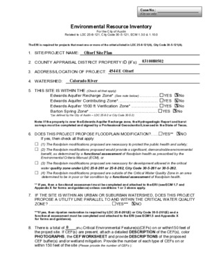
Case No.: (City use only) Environmental Resource Inventory For the City of Austin Related to LDC 25-8-121, City Code 30-5-121, ECM 1.3.0 & 1.10.0 The ERI is required for projects that meet one or more of the criteria listed in LDC 25-8-121(A), City Code 30-5-121(A). 1. SITE/PROJECT NAME: 2. COUNTY APPRAISAL DISTRICT PROPERTY ID (#’s): 3. ADDRESS/LOCATION OF PROJECT: 4. WATERSHED: 5. THIS SITE IS WITHIN THE (Check all that apply) Edwards Aquifer Recharge Zone* (See note below) .................. YES No Edwards Aquifer Contributing Zone*.................................. YES No Edwards Aquifer 1500 ft Verification Zone* ....................... YES No Barton Spring Zone* .......................................................... YES No *(as defined by the City of Austin – LDC 25-8-2 or City Code 30-5-2) Note: If the property is over the Edwards Aquifer Recharge zone, the Hydrogeologic Report and karst surveys must be completed and signed by a Professional Geoscientist Licensed in the State of Texas. 6. DOES THIS PROJECT PROPOSE FLOODPLAIN MODIFICATION?.......YES** NO If yes, then check all that apply: (1) The floodplain modifications proposed are necessary to protect the public health and safety; (2) The floodplain modifications proposed would provide a significant, demonstrable environmental benefit, as determined by a functional assessment of floodplain health as prescribed by the Environmental Criteria Manual (ECM), or (3) The floodplain modifications proposed are necessary for development allowed in the critical water quality zone under LDC 25-8-261 or 25-8-262, City Code 30-5-261 or 30-5-262. (4) The floodplain modifications proposed are outside of the Critical Water Quality Zone in an area determined to be in poor or fair condition by a functional assessment of floodplain health. ** If yes, then a functional assessment must be completed and attached to the ERI (see ECM 1.7 and Appendix X for forms and guidance) unless conditions 1 or 3 above apply. 7. IF THE SITE IS WITHIN AN URBAN OR SUBURBAN WATERSHED, DOES THIS PROJECT PROPOSE A UTILITY LINE PARALLEL TO AND WITHIN THE CRITICAL WATER QUALITY ZONE? ......................................................... YES*** NO ***If yes, then riparian restoration is required by LDC 25-8-261(E) or City Code 30-5-261(E) and a functional assessment must be completed and attached to the ERI (see ECM1.5 and Appendix X for forms and guidance). 8. There is a total of (#’s) Critical Environmental Feature(s)(CEFs) on or within150 feet of the project site. If CEF(s) are present, attach a detailed DESCRIPTION of the CEF(s), color PHOTOGRAPHS, the CEF WORKSHEET and provide DESCRIPTIONS of the proposed CEF buffer(s) and/or wetland mitigation. Provide the number of each type of CEFs on or within 150 feet of the site (Please provide the number of CEFs ): (#’s) Spring(s)/Seep(s) (#’s) Point Recharge Feature(s) (#’s) Bluff(s) (#’s) Canyon Rimrock(s) (#’s) Wetland(s) Note: Standard buffers for CEFs are 150 feet, with a maximum of 300 feet for point recharge features. Except for wetlands, if the standard buffer is not provided, you must provide a written request for an administrative variance from LDC 25-8-281(C)(1) and provide written findings of fact to support your request. Request forms for administrative variances from requirements stated in LDC 25-8-281 are available from Watershed Protection Department. 9. The following site maps are attached at the end of this report (Check all that apply and provide): All ERI reports must include: Site Specific Geologic Map with 2-ft Topography Historic Aerial Photo of the Site Site Soil Map Critical Environmental Features and Well Location Map on current Aerial Photo with 2-ft Topography Only if present on site (Maps can be combined): Edwards Aquifer Recharge Zone with the 1500-ft Verification Zone (Only if site is over or within 1500 feet the recharge zone) Edwards Aquifer Contributing Zone Water Quality Transition Zone (WQTZ) Critical Water Quality Zone (CWQZ) City of Austin Fully Developed Floodplains for all water courses with up to 64-acres of drainage 10. HYDROGEOLOGIC REPORT – Provide a description of site soils, topography, and site specific geology below (Attach additional sheets if needed): Surface Soils on the project site is summarized in the table below and uses the SCS Hydrologic Soil Groups*. If there is more than one soil unit on the project site, show each soil unit on the site soils map. Soil Series Unit Names, Infiltration Characteristics & Thickness *Soil Hydrologic Groups Definitions (Abbreviated) Soil Series Unit Name & Subgroup** Group* Thickness (feet) A. Soils having a high infiltration rate when thoroughly wetted. B. Soils having a moderate infiltration rate when thoroughly wetted. C. Soils having a slow infiltration rate when thoroughly wetted. D. Soils having a very slow infiltration rate when thoroughly wetted. **Subgroup Classification – See Classification of Soil Series Table in County Soil Survey. WPD ERM ERI-2014-01 Page 2 of 6 Description of Site Topography and Drainage (Attach additional sheets if needed): List surface geologic units below: Group Formation Member Geologic Units Exposed at Surface Brief description of site geology (Attach additional sheets if needed): Wells – Identify all recorded and unrecorded wells on site (test holes, monitoring, water, oil, unplugged, capped and/or abandoned wells, etc.): There are (#) wells present on the project site and the locations are shown and labeled (#’s)The wells are not in use and have been properly abandoned. (#’s)The wells are not in use and will be properly abandoned. (#’s)The wells are in use and comply with 16 TAC Chapter 76. There are (#’s) wells that are off-site and within 150 feet of this site. WPD ERM ERI-2014-01 Page 3 of 6 11. THE VEGETATION REPORT – Provide the information requested below: Brief description of site plant communities (Attach additional sheets if needed): There is woodland community on site …………………….YES NO (Check one). If yes, list the dominant species below: Woodland species Common Name Scientific Name There is grassland/prairie/savanna on site……………..YES NO (Check one). If yes, list the dominant species below: Grassland/prairie/savanna species Common Name Scientific Name There is hydrophytic vegetation on site ………………..YES NO (Check one). If yes, list the dominant species in table below (next page): WPD ERM ERI-2014-01 Page 4 of 6 Hydrophytic plant species Common Name Scientific Name Wetland Indicator Status A tree survey of all trees with a diameter of at least eight inches measured four and one- half feet above natural grade level has been completed on the site. YES NO (Check one). 12. WASTEWATER REPORT – Provide the information requested below. On-site system(s) Wastewater for the site will be treated by (Check of that Apply): City of Austin Centralized sewage collection system Other Centralized collection system Note: All sites that receive water or wastewater service from the Austin Water Utility must comply with City Code Chapter 15-12 and wells must be registered with the City of Austin The site sewage collection system is designed and will be constructed to in accordance to all State, County and City standard specifications. YES NO (Check one). Calculations of the size of the drainfield or wastewater irrigation area(s) are attached at the end of this report or shown on the site plan. YES NO Not Applicable (Check one). Wastewater lines are proposed within the Critical Water Quality Zone? YES NO (Check one). If yes, then provide justification below: WPD ERM ERI-2014-01 Page 5 of 6 Is the project site is over the Edwards Aquifer? YES NO (Check one). If yes, then describe the wastewater disposal systems proposed for the site, its treatment level and effects on receiving watercourses or the Edwards Aquifer. 13. One (1) hard copy and one (1) electronic copy of the completed assessment have been provided. Date(s) ERI Field Assessment was performed: Date(s) My signature certifies that to the best of my knowledge, the responses on this form accurately reflect all information requested. Print Name Signature Telephone Email Address Name of Company Date For project sites within the Edwards Aquifer Recharge Zone, my signature and seal also certifies that I am a licensed Professional Geoscientist in the State of Texas as defined by ECM 1.12.3(A). P.G. Seal WPD ERM ERI-2014-01 Page 6 of 6 City of Austin Environmental Resource Inventory - Critical Environmental Feature Worksheet Project Name: Project Address: Site Visit Date: Environmental Resource Inventory Date: 1 2 3 4 9 5 6 7 8 Primary Contact Name: Phone Number: Prepared By: Email Address: FEATURE TYPE FEATURE ID FEATURE LONGITUDE (WGS 1984 in Meters) (WGS 1984 in Meters) FEATURE LATITUDE WETLAND DIMENSIONS (ft) RIMROCK/BLUFF DIMENSIONS (ft) coordinate notation coordinate notation X Y Length Avg Height {Wetland,Rimrock, Bluffs,Recharge Feature,Spring} (eg S-1) RECHARGE FEATURE DIMENSIONS Y Z Trend X Springs Est. Discharge cfs City of Austin Use Only CASE NUMBER: For rimrock, locate the midpoint of the segment that describes the feature. For wetlands, locate the approximate centroid of the feature and the estimated area. For a spring or seep, locate the source of groundwater that feeds a pool or stream. DMS DD YES NO Wetland Rimrock Recharge Feature Spring Seep Please state the method of coordinate data collection and the approximate precision and accuracy of the points and the unit of measurement. Method Accuracy GPS Surveyed Other sub-meter □ □ □ Professional Geologists apply seal below □ □ □ > 1 meter meter WPD ERM ERI-CEF-01 Page 7 of 8 Property Profile Geological Map with 2ft Contours Legend Property Addresses Jurisdictions (No Fill) FULL PURPOSE Jurisdictions Fill Jurisdiction FULL PURPOSE Planimetrics Survey 2 Contours Year-2021 2 Ft Contours 10 Ft Contours 10 Ft Contours Notes 0 150 300 ft 10/31/2022 This product is for informational purposes and may not have been prepared for or be suitable for legal, engineering, or surveying purposes. It does not represent an on-the-ground survey. This product has been produced by the City of Austin for the sole purpose of geographic reference. No warranty is made by the City of Austin regarding specific accuracy or completeness. Property Profile 1977 Aerial Photo Legend Jurisdictions Fill Jurisdiction FULL PURPOSE 0 150 300 ft 10/31/2022 This product is for informational purposes and may not have been prepared for or be suitable for legal, engineering, or surveying purposes. It does not represent an on-the-ground survey. This product has been produced by the City of Austin for the sole purpose of geographic reference. No warranty is made by the City of Austin regarding specific accuracy or completeness. Notes Property Profile 2008 Aerial Photo Legend Property Addresses Jurisdictions (No Fill) FULL PURPOSE Jurisdictions Fill Jurisdiction FULL PURPOSE 0 150 300 ft 10/31/2022 This product is for informational purposes and may not have been prepared for or be suitable for legal, engineering, or surveying purposes. It does not represent an on-the-ground survey. This product has been produced by the City of Austin for the sole purpose of geographic reference. No warranty is made by the City of Austin regarding specific accuracy or completeness. Notes W ' ' 4 3 ' 3 4 ° 7 9 W ' ' 4 3 ' 3 4 ° 7 9 0 8 6 4 4 3 3 0 4 6 4 4 3 3 0 0 6 4 4 3 3 0 6 5 4 4 3 3 0 2 5 4 4 3 3 0 8 4 4 4 3 3 0 4 4 4 4 3 3 30° 13' 39'' N 622590 622630 622670 622710 622750 622790 622830 622870 622910 622950 Custom Soil Resource Report Map—Hydrologic Soil Group Soil Map may not be valid at this scale. 30° 13' 31'' N 622590 622630 622670 622710 622750 622790 622830 622870 622910 622950 Map Scale: 1:1,760 if printed on A landscape (11" x 8.5") sheet. N 0 25 50 100 Feet 50 0 Map projection: Web Mercator Corner coordinates: WGS84 Edge tics: UTM Zone 14N WGS84 100 200 300 Meters 150 19 W ' ' 0 2 ' 3 4 ° 7 9 30° 13' 39'' N 0 8 6 4 4 3 3 0 4 6 4 4 3 3 0 0 6 4 4 3 3 0 6 5 4 4 3 3 0 2 5 4 4 3 3 0 8 4 4 4 3 3 30° 13' 31'' N W ' ' 0 2 ' 3 4 ° 7 9 Custom Soil Resource Report MAP LEGEND MAP INFORMATION Area of Interest (AOI) Area of Interest (AOI) Soils Soil Rating Polygons C D C/D Not rated or not available Water Features Streams and Canals Transportation Rails Interstate Highways US Routes Major Roads Local Roads Background Aerial Photography A/D B/D C/D A B C D A B C D A/D B/D C/D A/D A B B/D Not rated or not available Soil Rating Lines Not rated or not available Soil Rating Points 20 The soil surveys that comprise your AOI were mapped at 1:24,000. Warning: Soil Map may not be valid at this scale. Enlargement of maps beyond the scale of mapping can cause misunderstanding of the detail of mapping and accuracy of soil line placement. The maps do not show the small areas of contrasting soils that could have been shown at a more detailed scale. Please rely on the bar scale on each map sheet for map measurements. Source of Map: Natural Resources Conservation Service Web Soil Survey URL: Coordinate System: Web Mercator (EPSG:3857) Maps from the Web Soil Survey are based on the Web Mercator projection, which preserves direction and shape but distorts distance and area. A projection that preserves area, such as the Albers equal-area conic projection, should be used if more accurate calculations of distance or area are required. This product is generated from the USDA-NRCS certified data as of the version date(s) listed below. Soil Survey Area: Travis County, Texas Survey Area Data: Version 21, Sep 12, 2019 Soil map units are labeled (as space allows) for map scales 1:50,000 or larger. Date(s) aerial images were photographed: May 27, 2018—Nov 16, 2018 The orthophoto or other base map on which the soil lines were compiled and digitized probably differs from the background imagery displayed on these maps. As a result, some minor shifting of map unit boundaries may be evident. Custom Soil Resource Report Table—Hydrologic Soil Group Map unit symbol Map unit name Rating Acres in AOI Percent of AOI FhF3 HnC2 Ferris-Heiden complex, 8 to 20 percent slopes, severely eroded D Houston Black clay, 3 to D 5 percent slopes, moderately eroded Totals for Area of Interest 12.1 0.2 12.3 98.5% 1.5% 100.0% Rating Options—Hydrologic Soil Group Aggregation Method: Dominant Condition Component Percent Cutoff: None Specified Tie-break Rule: Higher 21