20221116-004: 1703 N River Hills Rd Marina Reconstruction SP-2022-0167D dredge variance packet 2 of 2 — original pdf
Backup
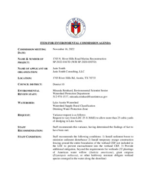
ITEM FOR ENVIRONMENTAL COMMISSION AGENDA COMMISSION MEETING DATE: November 16, 2022 NAME & NUMBER OF PROJECT: 1703 N. River Hills Road Marina Reconstruction SP-2022-0167D (W/R SP-2020-0307D) NAME OF APPLICANT OR ORGANIZATION: Janis Smith Janis Smith Consulting, LLC LOCATION: 1703 River Hills Rd, Austin, TX 78733 COUNCIL DISTRICT: District 10 ENVIRONMENTAL REVIEW STAFF: WATERSHED: REQUEST: STAFF RECOMMENDATION: STAFF CONDITION: Miranda Reinhard, Environmental Scientist Senior Watershed Protection Department 512-978-1537, miranda.reinhard@austintexas.gov Lake Austin Watershed Watershed Supply Rural Classification Drinking Water Protection Zone Variance request is as follows: Request to vary from LDC 25-8-368(E) to allow more than 25 cubic yards of dredging in Lake Austin. Staff recommends this variance, having determined the findings of fact to have been met. Staff recommends the following conditions: 1) Install sediment boom to minimize sediment disturbance 2) Install temporary orange construction fencing around the entire boundaries of the wetland CEF not included in the LOC to prevent encroachment into the wetland CEF. 3) Provide additional mitigation, beyond the requirements for wetlands (32 plantings of American water willow (Justicia americana), giant cutgrass (Zizaniopsis miliacea), or other herbivory resistant obligate wetland species emerged in the water along the shoreline) Development Services Department Staff Recommendations Concerning Required Findings Project Name: 1703 N. River Hills Road Mariana Reconstruction SP-2022- 0167D (W/R SP-2020-0307D) Ordinance Standard: Watershed Protection Ordinance (current code) Variance Request: Request to vary from LDC 25-8-368(E) to allow more than 25 cubic yards of dredging in Lake Austin. Include an explanation with each applicable finding of fact. A. Land Use Commission variance determinations from Chapter 25-8-41 of the City Code: 1. 2. The project proposes to modify an existing marina, built prior to 1965, The requirement will deprive the applicant of a privilege available to owners of similarly situated property with approximately contemporaneous development subject to similar code requirements. Yes by replacing the existing 21 slips with 16 code-compliant slips, within the existing footprint. A “similarly situated property with approximately contemporaneous development subject to similar code requirements” is SP- 2018-0221C, West Harbour Marina. The project was granted a variance in 2019 to dredge 422 cubic yards (CY) or about 16 CY per boat slip. The current variance application is to dredge 97.4 CY, or about 6.1 CY per boat slip. LDC 25-2-1176(B) allows construction of a marina. LDC 25-2-963 (D) allows modification and maintenance of non-complying docks. LDC 25-8-368(E) allows up to 25 CY of dredging in a lake for a single plan permit application. That is, a similar project could be built new or modified under current code; and dredging up to 25 CY would be permitted for construction of a single boat dock. The variance is required to allow a quantity of dredging that is dictated by the number of boat slips, and is less per boat slip (6.1 CY) than the quantity of dredging allowed by code for a single boat slip (25 CY). The variance: a) Is not necessitated by the scale, layout, construction method, or other design decision made by the applicant, unless the design decision provides greater overall environmental protection than is achievable without the variance; B. b) c) Yes The amount of dredge requested is the minimum amount needed to maintain an existing marina. The project’s location is dictated by the location of the existing dock, and the existing dock depth isn’t navigable for the bigger boats of today and the lift systems required for them. This site will be dredged to a water depth of about 3.5 ft. deep from the normal pool elevation allowing clearance for the bow of the boat and a boat lift cradle underneath the boat. Is the minimum deviation from the code requirement necessary to allow a reasonable use of the property; The code allows up to 25 CY of dredging associated with Yes construction of a single-slip dock. The project proposes 6.1 CY per slip. A variance for dredge greater than 25 CY is necessary to build a navigable 16-slip boat dock within the footprint of the existing boat dock. The proposed dredge for each slip is far lower (6.1 CY/slip) than dredge allowed (25 CY/slip) if the boat dock was permitted on a slip- by-slip basis. Does not create a significant probability of harmful environmental consequences. 3. Yes A sediment boom will be installed prior to construction and maintained for the duration of the project to minimize discharges to the lake. Denying dredge to a navigable depth potentially harms the water quality of the lake due to churning of the lakebed by boats leaving sediment-laden water in their wake. Development with the variance will result in water quality that is at least equal to the water quality achievable without the variance. This variance is necessary to permit the slips on one site permit. Yes Dredging the site is necessary to protect the water quality of the lake by eliminating the churning of the lakebed by boat traffic which leads to sediment- laden lake water. In addition, this project will improve the water quality of the lake by replacing a bulkhead that is currently allowing sediment to enter Lake Austin. The project proposes wetland mitigation and bulkhead mitigation, installing temporary orange construction fencing around the entire boundaries of the wetland Critical Environmental Feature (CEF) not included in the limits of construction (LOC) to prevent encroachment into the wetland, and is designed to protect the trees on-site. Additional wetland plantings and protecting of the wetland CEF and trees will positively impact water quality. The Land Use Commission may grant a variance from a requirement of Section 25-8-422 (Water Supply Suburban Water Quality Transition Zone), Section 25-8-452 (Water Supply Rural Water Quality Transition Zone), Section 25-8-482 (Barton Springs Zone Water Quality Transition Zone), Section 25-8-368 (Restrictions on Development Impacting Lake Austin, Lady Bird Lake, and Lake Walter E. Long), or Article 7, Division 1 ( Critical Water Quality Zone Restrictions ), after determining that:: 1. 2. 3. The criteria for granting a variance in Subsection (A) are met; Yes The criteria for granting the variance are met. The dredge request is the minimum amount needed to maintain an existing marina that has been silted in over the years. The variance request is not the result of design choice and does not create a significant probability of harmful environmental consequences. The requirement for which a variance is requested prevents a reasonable, economic use of the entire property; Yes The purpose of the proposed work is to rehabilitate an existing dock. The dredge limit for a site plan permit is 25 CY no matter the number of boat slips. This site plan permit application entails 16 slips and proposed dredge of 6.1 CY /slip or far less dredge than if the slips were permitted separately. The variance is the minimum deviation from the code requirement necessary to allow a reasonable, economic use of the entire property. Yes The amount of dredge requested is the minimum amount needed to maintain an existing marina. The dredge amount is the minimum dredge required to ensure a navigable boat dock for modern boats. The proposed dredge depth of 3.5 ft is routinely administratively approved by the environmental review staff. Staff Determination: Staff determines that the findings of fact have been met. Staff recommends the following condition: 1) Install sediment boom to minimize sediment disturbance 2) Install temporary orange construction fencing around the entire boundaries of the wetland CEF not included in the LOC to prevent encroachment into the wetland CEF. 3) Provide additional mitigation, beyond the requirements for wetlands (32 plantings of American water willow (Justicia americana), giant cutgrass (Zizaniopsis miliacea), or other herbivory resistant obligate wetland species emerged in the water along the shoreline) _____________________________ Wetland Biologist (Miranda Reinhard) Reviewer (WPD) _____________________________ Environmental Review (John Clement) Program Manager (WPD) _____________________________ Deputy Environmental (Liz Johnston) Officer (WPD) Date:11/4/2022 Date: Date: 11/4/2211/04/2022 April 15, 2021 ENVIRONMENTAL COMMISSION VARIANCE APPLICATION FORM Nikelle Meade and Janis J. Smith, P.E. for YYYYY INC 401 Congress Avenue # 2650 Austin, TX 78701 512-472-5456 Nikelle.meade@huschblackwell.com, jsmith@janissmithconsulting.com PROJECT DESCRIPTION Applicant Contact Information Name of Applicant Street Address City State ZIP Code Work Phone E-Mail Address Case Name Case Number Address or Location Environmental Reviewer Name Environmental Resource Management Reviewer Name Applicable Ordinance Variance Case Information 1703 N. River Hills Road Marina Reconstruction SP-2022-0167D 1703 N. River Hills Road Miranda Reinhard LDC 25-8-368(E) Dredge over 25 CY Watershed Name Lake Austin Watershed Classification ☐Urban ☐ Suburban ☐Water Supply Suburban X Water Supply Rural ☐ Barton Springs Zone City of Austin | Environmental Commission Variance Application Guide 1 April 15, 2021 Edwards Aquifer Recharge Zone ☐ Barton Springs Segment X Not in Edwards Aquifer Zones ☐ Northern Edwards Segment Edwards Aquifer Contributing Zone Distance to Nearest Classified Waterway ☐ Yes X No The dredging will take place in Lake Austin Water and Waste Water service to be provided by Austin Water Request The variance request is as follows (Cite code references: LDC 25-8-368(E) Dredge over 25 CY Impervious cover square footage: acreage: percentage: Provide general description of the property (slope range, elevation range, summary of vegetation / trees, summary of the geology, CWQZ, WQTZ, CEFs, floodplain, heritage trees, any other notable or outstanding characteristics of the property) Existing ________ ________ ________ Proposed _________ _________ _________ The proposed project site contains an abandoned restaurant, parking lot, bulkhead, existing 18-slip marina (the north dock) and a non-operational fueling station with 3 slips (the south dock) constructed prior to 1965. It was the site of The Pier Restaurant which had been open, in one form or another, from the 1920s to 2005. The 4.46 ac legal parcel on the shoreline of a Lake Austin is shown on Attachment 1, Project Site. The site is zoned CS-1. Except for an access road traversing the property, all of the property elements are on the Lake Austin shoreline. There are a number of trees on the site, but the shoreline is dominated by the restaurant building and flat work that served as a dance floor and restaurant service area. There’s a group of trees, some of which are heritage trees, on the shoreline by the south dock. All fueling infrastructure was removed. Attachment 2 contains pictures of the site. The condition of both boat docks is perilous. The docks were red-tagged in October 2019, and a site plan is required to reconstruct the docks. The proposed project will reconstruct the docks, bulkhead, and a fueling station. It won’t reconstruct the restaurant or other facilities. The north dock will have 16 slips, and the south dock will have the capacity to moor 3 boats. By today’s permitting requirements, the old structures were a 21-slip marina. The replacement dock will be a 16-slip marina and will replace the existing structures with code-compliant docks within the existing footprints. The project also includes the installation of a bulkhead designed to protect and preserve the trees on-site while reinforcing a bulkhead that has partially collapsed. This variance application for Dredge Over 25 CY is necessary to ensure that the docks are navigable for modern boats and can accommodate current lifts. Attachment 3 contains the existing and proposed dock plan and elevation views. Attachment 4 contains the basis of the Findings of Fact. City of Austin | Environmental Commission Variance Application Guide 2 April 15, 2021 Project: Ordinance: 1. 2. Clearly indicate in what way the proposed project does not comply with current Code (include maps and exhibits) This permit specifies 97.4 CY of dredge for the docks, or about 6 CY per boat slip. Current code allows 25 CY of dredge for a site plan permit whether the permit is regulating one slip or, in this case, 16 slips. For this boat dock, code actually would administratively approve 400 CY of dredge if the slips were permitted individually. FINDINGS OF FACT As required in LDC Section 25-8-41, in order to grant a variance the Land Use Commission must make the following findings of fact: Include an explanation with each applicable finding of fact. A. Land Use Commission variance determinations from Chapter 25-8-41 of the City Code: The requirement will deprive the applicant of a privilege available to owners of similarly situated property with approximately contemporaneous development subject to similar code requirements. Yes / No [provide summary of justification for determination] See Attachment 4, Findings of Fact The variance: a) Is not necessitated by the scale, layout, construction method, or other design decision made by the applicant, unless the design decision provides greater overall environmental protection than is achievable without the variance; b) c) Yes / No See Attachment 4, Findings of Fact [provide summary of justification for determination] Is the minimum deviation from the code requirement necessary to allow a reasonable use of the property; Yes / No See Attachment 4, Findings of Fact [provide summary justification for determination] Does not create a significant probability of harmful environmental consequences. City of Austin | Environmental Commission Variance Application Guide 3 April 15, 2021 Yes / No See Attachment 4, Findings of Fact [provide summary justification for determination] 3. Development with the variance will result in water quality that is at least equal to the water quality achievable without the variance. Yes / No [provide summary justification for determination] See Attachment 4, Findings of Fact B. Additional Land Use Commission variance determinations for a requirement of Section 25-8-422 (Water Quality Transition Zone), Section 25-8-452 (Water Quality Transition Zone), Article 7, Division 1 (Critical Water Quality Zone Restrictions), or Section 25-8-652 (Development Impacting Lake Austin, Lady Bird Lake, and Lake Walter E. Long): 1. The criteria for granting a variance in Subsection (A) are met; Yes / No [provide summary of justification for determination] See Attachment 4, Findings of Fact The requirement for which a variance is requested prevents a reasonable, economic use of the entire property; Yes / No [provide summary of justification for determination] See Attachment 4, Findings of Fact The variance is the minimum deviation from the code requirement necessary to allow a reasonable, economic use of the entire property. 2. 3. Yes / No [provide summary of justification for determination] See Attachment 4, Findings of Fact **Variance approval requires all above affirmative findings. City of Austin | Environmental Commission Variance Application Guide 4 April 15, 2021 A Exhibits for Commission Variance o Aerial photos of the site o Site photos o Aerial photos of the vicinity o Context Map—A map illustrating the subject property in relation to developments in the vicinity to include nearby major streets and waterways o Topographic Map - A topographic map is recommended if a significant grade change on the subject site exists or if there is a significant difference in grade in relation to adjacent properties. o For cut/fill variances, a plan sheet showing areas and depth of cut/fill with topographic elevations. o Site plan showing existing conditions if development exists currently on the property o Proposed Site Plan- full size electronic or at least legible 11x17 showing proposed development, include tree survey if required as part of site or subdivision plan o Environmental Map – A map that shows pertinent features including Floodplain, CWQZ, WQTZ, CEFs, Setbacks, Recharge Zone, etc. o An Environmental Resource Inventory pursuant to ECM 1.3.0 (if required by 25-8-121) o Applicant’s variance request letter City of Austin | Environmental Commission Variance Application Guide 5 ATTACHMENT 1 PROJECT SITE 1703 N. RIVER HILLS ROAD MARINA RECONSTRUCTION LINE L1 L2 L3 L4 L5 L6 L7 L8 L9 L10 L11 L12 L13 L14 L15 L16 LINE TABLE BEARING S 78°14'06" W S 73°25'06" W S 41°23'06" W S 28°17'31" W S 28°02'44" W S 28°01'30" W S 27°23'30" W S 27°51'31" W N 18°18'03" W N 31°53'44" W N 18°00'42" W N 64°42'19" E N 69°58'21" E N 89°10'21" E S 10°42'39" E S 81°23'36" W LENGTH 41.23' 8.35' 15.37' 9.19' 240.42' 179.54' 39.12' 45.11' 261.76' 195.77' 119.75' 41.93' 421.08' 127.00' 208.80' 78.18' TIRES MADE EASY INC ABS 808 SUR 39 WOFFORD W ACR 10.917 (1-D-1W) DEED DOC. #2012045404TR ZONING: LA L12 693 692 690 691 5 3 5 0 3 5 1 1 L 5 2 5 718 0 4 5 717 716 714 5 3 5 0 1 L 712 713 704 X X 705 707 706 700 701 X 711 710 709 708 5 2 5 X 699 0 3 5 X X 698 697 696 687 X X X X X X X X X X X X X X X X X X L13 X X 688 689 E 686 COA AND FEMA 100-YR FULLY DEVELOPED FLOODPLAIN/BFE ELEV = 499.38 0 2 5 E E C/M S L O 665 LOC/MS LOC/MS LOC/MS LOC/MS 664 663 659 FENCING AND GATE TO BE REMOVED AS REQUIRED 662 TIRES MADE EASY INC ABS 627 SUR 39 WOFFORD W ACR 4.4650 (1-D-1W) DEED DOC. #2008021052TR ZONING: CS E S C/M LO S C/M LO 673 672 671 668 666 667 S C / M O L S C/M LO 5 1 5 S C/M LO S C/M LO S C/M LO 670 S C/M LO L O C / M S S C/M LO E 0 2 5 S C/M LO 653 S C/M LO 715 TREE TO BE REMOVED FOR FIRE LANE CONSTRUCTION E S C/M LO S C/M LO S C/M LO S C/M LO C / M O L S L O S C / M S C / M O L O L S C / M S C/M LO E E S C/M LO S C / M O L L O C/M S S C/M LO L O C/M S E S C/M LO S C/M LO S C/M LO S C/M LO EXISTING ROAD TO BE DEMOLISHED AND REBUILT 5 1 5 E 652 E EXISTING WETLAND CEF APPROX. 30.0 SF L14 684 495 LOC/MS L O C M S / L O C M S / L O C / M S 5 1 0 L O C / M S L O C / M S 5 0 5 LOC/MS L O C / M S 0 0 5 682 681 683 EXISTING BUILDING C O L C O L C O L LOC/MS LOC/MS LOC/MS LOC/MS LOC/MS LOC/MS EXISTING CONCRETE LOC/MS C O L LOC/MS LOC/MS L O C / M S L O C / M S LOC/MS K C A B T E S Z Q W C 0' 0 1 / L M S O C PALM TO BE REMOVED 660 661 669 654 655 656 657 658 LOC/MS 650 0 1 5 LOC/MS LOC/MS LOC/MS LOC/MS LOC/MS LOC/MS LOC/MS LOC/MS EXISTING CONCRETE LOC/MS LOC/MS LOC/MS L O C / M S L O C / M S 648 647 651 EXISTING WETLAND CEF APPROX. 2918.5 SF 674 L O C / M S LOC/MS LOC/MS 649 644 643 645 646 L 4 L2 3 L L1 EXISTING = PROPOSED SHORELINE LOCATION ELEV = 492.8' C O L 680 C O L 5 1 L LOC/MS 679 678 S C/M O L 675 675 0 9 4 676 676 L16 LOC LOC ' 1 TC . 8 6 LOC TC T C T C T C T C L O C L O C L O C LOC 8 8 4 LOC 9 8 4 6 8 4 4 8 4 2 8 4 0 8 4 TRAVIS COUNTY WCID #20 LOT 42 BLK A ROB ROY ON THE LAKE SEC 1 DEED DOC. #NOT AVAILABLE ZONING: LA E L 5 E 685 E TIRES MADE EASY INC ABS 627 SUR 39 WOFFORD W ACR 22.4500 (1-D-1W)DEED DOC. #NOT AVAILABLE ZONING: ILA USE: XX S C/M LO E S C/M LO S C/M LO S C/M LO S C/M LO E S C/M LO S C/M LO S C/M LO 0 2 5 S C/M LO S C/M LO E S C/M LO S C/M LO S C/M LO E S C / M O L L O C / M S E L 6 E E W E W 15' WATERLINE EASEMENT VOL 11149/665 W 0 2 5 W W X X X 9 L 5 2 5 X L O C / M S X L O C / M S 695 694 L O C / M S X X X L O C / M S L O C M S / L O C M S / L O C M S / L O C / M S 702 L O C / M S E L O C / M S L O C / M S L 7 L O C M S / E L O C M S / L 8 703 S C/M O L L O C / M S L O C / M S S C/M LO W W W DRAINAGE EASEMENT DOC # 2008021051 TREES TO REMAIN TREES TO REMAIN TREES TO REMAIN TREE TAG # SPECIES AND DIAMETER TREE TAG # SPECIES AND DIAMETER TREE TAG # SPECIES AND DIAMETER 704 705 706 707 708 709 710 711 712 713 714 715 716 717 718 HACKBERRY 8 ELM 18 LIVE OAK 16 15 DEAD LIVE OAK 18 DEAD LIVE OAK 18 DEAD ELM 12 LIVE OAK 36 DEAD HACKBERRY 12 ELM 16 HACKBERRY 11 HACKBERRY 11 CHINA BERRY 16 CHINA BERRY 10 9 LIVE OAK 52 DEAD LIVE OAK 54 DEAD TREES TO BE REMOVED TREE TAG # SPECIES AND DIAMETER 653 HACKBERRY 27 643 644 645 646 647 648 649 650 651 652 654 655 656 657 658 659 660 661 662 663 664 665 666 667 668 669 670 671 672 HACKBERRY 8 ELM 12 ELM 9 ELM 12 ELM 10 ELM 36 ELM 12 ELM 40 HACKBERRY 9 PECAN 20 PECAN 23 HACKBERRY 9 HACKBERRY 9 HACKBERRY 19 HACKBERRY 9 PECAN 20 PECAN 14 HACKBERRY 10 HACKBERRY 24 HACKBERRY 20 PECAN 13 PECAN 14 PECAN 12 HACKBERRY 21 HACKBERRY 10 PECAN 20 PECAN 29 HACKBERRY 16 HACKBERRY 10 673 674 675 676 677 678 679 681 682 683 684 685 686 687 688 689 690 691 692 693 694 695 696 697 698 699 700 701 702 703 PECAN 15 COTTONWOOD 48 CYPRESS 25 CYPRESS 38 CYPRESS 24 CYPRESS 23 COTTONWOOD 22 COTTONWOOD 54 COTTONWOOD 30 COTTONWOOD 14 12 COTTONWOOD 40 ELM 34 ELM 20 CEDAR 13 CEDAR 12 CEDAR15 HACKBERRY 14 HACKBERRY 12 CEDAR 12 ELM 12 HACKBERRY 12 10 HACKBERRY 12 ELM 10 ELM 16 CHINA BERRY 14 LIVE OAK 38 DEAD LIVE OAK 24 18 DEAD HACKBERRY 12 HACKBERRY 10 HACKBERRY 24 0 9 4 9 8 4 8 8 4 6 8 4 LEGEND EXISTING DOCK TO BE DEMOLISHED EXISTING STRUCTURE TO REMAIN EXISTING SHORELINE PROPERTY BOUDARY CWQZ SETBACK COA AND FEMA 100-YR FLOODPLAIN LIMIT OF CONSTRUCTION EXISTING OVERHEAD POWER LINE EXISTING POWER POLE TREE # TREE CRITICAL ROOT ZONE UNCOVERED SECOND STORY DECK WITH HANDRAILS C O L LOC TC 9 8 4 LOC TC 8 8 4 LOC 0 8 4 4 8 4 2 8 4 LIMIT OF CONSTRUCTION LOC LOC E 0 9 4 6 8 4 L O C L O C L O C L O C L O C L O C T C T C T C ' 2 . 4 1 2 L O C L O C T C T C T C T C EXISTING DOCK FOOTPRINT INCLUDES THE AREA OCCUPIED BY BOATS PER BOAT DATA FROM 1984 N I T S U A E K A L EXISTING 21-SLIP BOAT DOCK NORTH DOCK CONTAINS 18 SLIPS SOUTH DOCK CONTAINS 3 SLIPS 214.2' WIDE x 68.1' DEEP DOCKS AND TO BE DEMOLISHED AND REBUILT SEE EXISTING DOCK PLAN/ELEVATION VIEWS ON SHEET 6 EXISTING BULKHEAD L O C APPROXIMATE COLORADO RIVER GRADIENT ELEV = 482.0 683 PROPOSED DOCK 5 1 L 679 678 0 9 4 676 676 675 675 EXISTING DOCK TO BE DEMOLISHED PROPOSED DOCK FOOTPRINT AREA = 6779.5 SF EXISTING DOCK FOOTPRINT AREA = 7609.5 SF EXISTING SITE PLAN EXISTING VS PROPOSED DOCK FOOTPRINTS 40 20 0 40 80 SCALE: 1" =40' 0 9 4 8 8 4 9 8 4 ' D V P P A I N O S V E R I E T A D . O N 2 2 0 2 , 8 2 Y L U J 9 2 7 3 - 4 1 9 - 2 1 5 3 0 7 8 7 s a x e T , n i t s u A d a o R r e v o t s e W 5 0 5 1 8 7 9 6 1 - F r e b m u N n o i t a r t s i g e R s r e e n i g n E l a n o i s s e f o r P f o d r a o B s a x e T C L L , g n i t l u s n o C h t i m S s i n a J D A O R S L L I H R E V R I . N 3 0 7 1 I N O T C U R T S N O C E R A N R A M I I I N A L P E T S S N O T D N O C G N T S X E I I I D 7 6 1 0 - 2 2 0 2 - P S - D R S L L I H R E V R I . N 3 0 7 1 DESIGNED: JJS APPROVED: JJS SCALE: AS SHOWN 1703 N. RIVER HILLS RD DATE: 8-03-2020 SHEET of 18 2 2 SP-2022-0167D ATTACHMENT 2 SITE PICTURES ATTACHMENT 3 EXISTING AND PROPOSED DOCK PLAN AND ELEVATION VIEWS 1703 N. RIVER HILLS ROAD MARINA RECONSTRUCTION EXISTING SHORELINE NORTH DOCK = 18 SLIPS UNCOVERED SECOND STORY DECK WITH HANDRAILS 18.2' X 15.6' 30.9' 6 8 . 1 ' 1 P I L S 4 4 . 4 ' 3 P L S I 4 P L S I 5 P L S I 6 P L S I 7 P L S I 8 P L S I 9 P L S I 0 1 P L S I 1 1 P L S I 2 1 P L S I 3 1 P L S I 4 1 P L S I 5 1 P L S I 6 1 P L S I 7 1 P L S I 8 1 P L S I 9 1 P L S I 0 2 P L S I 1 1 2 2 P P L L S S I I WALKWAY 169.6' ROOF OVER 1ST FLOOR DECK SLIP 2 24.2' SOUTH DOCK = 3 SLIPS COMBINED EXISTING FOOTPRINT OF THE NORTH AND SOUTH DOCKS = 7609.5 SF SOUTH DOCK DECK ELEVATION = APPROX. 493.4' NORTH DOCK DECK ELEVATION = APPROX. 493.4' 18.2' TOP OF RAIL = 509.5 TOP OF ROOF = 505.0 9.98 3.42 86.0' 16.7' WSE = 492.8 12.7' WSEL = 492.8' NORTH DOCK DECKING BETWEEN SLIPS SOME PLATFORMS REMAIN WHILE ONLY THE POSTS FOR SOME PLATFORMS REMAIN 214.2' WEST VIEW 4.0' 15.6' NORTH VIEW 214.2' PLAN VIEW 1" = 10' ELEVATION VIEWS 1" = 10' ' D V P P A I N O S V E R I E T A D . O N 2 2 0 2 , 8 2 Y L U J 9 2 7 3 - 4 1 9 - 2 1 5 3 0 7 8 7 s a x e T , n i t s u A d a o R r e v o t s e W 5 0 5 1 8 7 9 6 1 - F r e b m u N n o i t a r t s i g e R s r e e n i g n E l a n o i s s e f o r P f o d r a o B s a x e T C L L , g n i t l u s n o C h t i m S s i n a J D A O R S L L I H R E V R I . N 3 0 7 1 I N O T C U R T S N O C E R A N R A M I N A L P K C O D G N T S X E I I I S N O T A V E L E D N A D 7 6 1 0 - 2 2 0 2 - P S - D R S L L I H R E V R I . N 3 0 7 1 DESIGNED: JJS APPROVED: JJS SCALE: AS SHOWN 1703 N. RIVER HILLS RD DATE: 8-03-2020 SHEET of 18 6 6 SP-2022-0167D 1703 N. RIVER HILLS ROAD MARINA RECONSTRUCTION PROPOSED BULKHEAD/SHORELINE LOCATION PROPOSED BULKHEAD/SHORELINE LOCATION UNCOVERED SECOND STORY DECK WITH HANDRAIL 18.2' X 15.6' 4 4 P P L L S S I I 20.9' 5 5 P P I I L L S S 6 6 P P L L S S I I 7 7 P P L L S S I I 29.1' 25.0' 8 8 P P L L S S I I I I 9 9 P P L L S S 9.5' 40.4' 3 1 P L S I 25.0' 1 1 1 1 P P L L S S I I 2 1 P L S I 4 1 P L S I 5 1 P L S I 6 1 P L S I NAVIGATION LIGHT TYP. NAVIGATION LIGHT TYP. NAVIGATION LIGHT TYP. NORTH DOCK = 13 SLIPS NORTH DOCK = 13 SLIPS NAVIGATION LIGHT TYP. NAVIGATION LIGHT TYP. PROPOSED FOOTPRINT = 7038.9 SF NAVIGATION LIGHT TYP. NAVIGATION LIGHT TYP. 5 9 . 8 ' 1 P I L S 3 P I L S NAVIGATION LIGHT TYP. SLIP 2 24.5' NAVIGATION LIGHT TYP. SOUTH DOCK = 3 SLIPS COFFER WALLS 0 0 1 1 P P L L S S I I NAVIGATION LIGHT TYP. 163.4' TOP OF RAIL = 509.5 18.2' NAVIGATION LIGHT TYP. 207.1' PLAN VIEW 1" = 10' ELEVATION VIEWS 1" = 10' NAVIGATION LIGHT TYP. NAVIGATION LIGHT TYP. NAVIGATION LIGHT TYP. NAVIGATION LIGHT TYP. NAVIGATION LIGHT TYP. NAVIGATION LIGHT TYP. BOTH DOCKS TO BE CONSTRUCTED OF IPE WOOD NAVIGATION LIGHT TYP. NAVIGATION LIGHT TYP. NAVIGATION LIGHT TYP. NAVIGATION LIGHT TYP. NAVIGATION LIGHT TYP. BFE = 499.4' 24.5' 163.4' 80.4' COFFER WALLS 202.9' WEST VIEW 16.7' NAVIGATION LIGHT TYP. WSEL = 492.8 COFFER WALLS DECK ELEV = 494.8' TOE OF SLIP WSEL = 492.8 LOWEST STRUCTURAL MEMBER ELEV = 493.8' COFFER WALL LOCATION NORTH VIEW 4.0' 12.7' 15.6' ' D V P P A I N O S V E R I E T A D . O N 2 2 0 2 , 8 2 Y L U J 9 2 7 3 - 4 1 9 - 2 1 5 3 0 7 8 7 s a x e T , n i t s u A d a o R r e v o t s e W 5 0 5 1 8 7 9 6 1 - F r e b m u N n o i t a r t s i g e R s r e e n i g n E l a n o i s s e f o r P f o d r a o B s a x e T C L L , g n i t l u s n o C h t i m S s i n a J D A O R S L L I H R E V R I . N 3 0 7 1 I N O T C U R T S N O C E R A N R A M I N A L P K C O D D E S O P O R P I S N O T A V E L E D N A D 7 6 1 0 - 2 2 0 2 - P S - D R S L L I H R E V R I . N 3 0 7 1 DESIGNED: JJS APPROVED: JJS SCALE: AS SHOWN 1703 N. RIVER HILLS RD DATE: 8-03-2020 SHEET of 18 7 7 SP-2022-0167D ATTACHMENT 4 BASIS OF THE FINDINGS OF FACT A. 1. The requirement will deprive the applicant of a privilege available to owners of similarly situated property with approximately contemporaneous development subject to similar code requirements. YES. A “similarly situated property with approximately contemporaneous development subject to similar code requirements” is SP-2018-0221C, West Harbour Marina. The project was granted a variance in 2019 to dredge 422 CY or about 16 CY/slip. This variance application is to dredge about 6.1 CY/slip. 2. The variance: a. Is not necessitated by the scale, layout, construction method, or other design decision made by the applicant, unless the design decision provides greater overall environmental protection than is achievable without the variance; YES. The project’s location is dictated by the location of the existing dock, and the existing dock depth isn’t navigable for the bigger boats of today and the lift systems required for them. This site will be dredged to a water depth of about 3.5 ft. depth from the normal pool elevation allowing clearance for the bow of the boat and a boat lift cradle underneath the boat. In addition, permitting the slips in unison will require the oversight of the Corps of Engineers and the additional erosion controls required by the Corps. Those erosion controls are above and beyond what is required by the City of Austin, and those additional erosion controls would not be required if each slip was permitted individually with a limit of 25 CY/slip. So, without the variance, it would be possible to dredge this site with fewer erosion controls. With the approved variance, the site will be dredged 97.4 CY with enhanced erosion controls. b. Is the minimum deviation from the code requirement necessary to allow reasonable use of the property; YES. A variance for Dredge greater than 25 CY is necessary to build a navigable 16-slip boat dock. The proposed dredge for each slip is far lower (6.1 CY/slip) than dredge allowed (25 CY/slip) if the boat dock was permitted on a slip by slip basis. The COA permitting costs to permit the dock on a slip by slip basis would exceed $288,000 in city fees alone; those fees would render the project infeasible; and would not “allow reasonable use of the property”. c. Does not create a significant probability of harmful environmental consequences. YES. There are no harmful environmental impacts of the dredge. To the contrary, permitting the site with an approved variance for dredge over 25 CY will render a project with far greater erosion controls and more government oversight with the addition of the Corps of Engineers to the permitting authorities. If permitted separately, 400 CY (25 CY/slip) of dredge for the site could be approved administratively while this permit approves 97.4 CY (5.1 CY/slip) with enhanced erosion controls. Denying dredge to a navigable depth harms the water quality of the lake and yields constant churning of the lakebed by boats leaving sediment- laden water in their wake. Overall, the lakefront site is greatly improved environmentally by the proposed project. The slips will be reduced from 21 to 16 slips within the existing footprint. The bulkhead is designed to protect the trees on-site while reducing the flow of sediment into the lake. 3. Development with the variance will result in water quality that is at least equal to the water quality achievable without the variance. YES. This variance is necessary to permit the slips on one site plan permit. Permitting the slips in unison will require the oversight of the Corps of Engineers and the additional erosion controls required by the Corps. Those erosion controls are above and beyond what is required by the City of Austin, and those additional erosion controls would not be required if each slip was permitted individually with a limit of 25 CY/slip. So, without the variance, it would be possible to dredge this site up to 400 CY administratively with fewer erosion controls. With the approved variance, the site will be dredged 97.4 CY with enhanced erosion controls. Dredging the site is necessary to protect the water quality of the lake by eliminating the churning of the lakebed by boat traffic which leads to sediment- laden lake water. In addition, this project will improve the water quality of the lake by replacing a bulkhead that is currently allowing sediment to enter Lake Austin. B. 1. The criteria for granting a variance in Subsection (A) are met: YES. Please see answers to A (1), (2), and (3). 2. The requirement for which a variance is requested prevents a reasonable, economic use of the entirety of the property; YES. The dredge limit for a site plan permit is 25 CY no matter the number of boat slips. This site plan permit application entails 16 slips and proposes dredge of 5.1 CY/slip or far less dredge than if the slips were permitted separately. Permitting each slip separately would entail permitting fees in excess of $288,000 in City fees alone. Those fees make the project infeasible and would prevent “a reasonable, economic use of the entirety of the property”. 3. The variance is the minimum deviation from the code requirement necessary to allow a reasonable, economic use of the entire property; YES. The dredge amount is the minimum dredge required to ensure a navigable boat dock for modern boats. The proposed dredge depth of 3.5 ft. is routinely administratively approved by the environmental review staff. 1703 N. River Hills Road U1 7/30/22 ENGINEERING SUMMARY LETTER WITH NO-RISE CERTIFICATE ATTACHMENT 4 1505 Westover Road ! Austin, Texas 78703 ! www.janissmithconsulting.com ! TBPE Firm No. F-16978 Janis Smith Consulting, LLC Civil Engineering Consulting for Lake Austin Shoreline Projects August 1, 2020 City of Austin Director of Planning and Development Review P.O. Box 1088 Austin, Texas 78767 Re: Engineering Summary Letter and Report for 1703 N. River Hills Road Marina Reconstruction Dear Director: This project proposes to reconstruct a marina and reinforce an existing bulkhead under LDC 25-2-963. The existing structure has been red-tagged, and the case no. is CV-2019-209020. The site is located about 1.7 miles northwest of the intersection of River Hills Road and Bee Cave Road. It’s within the Austin Limited Purpose Jurisdiction and the Lake Austin watershed. Access for construction activities will be by water, and the project will be built this coming spring/summer. The existing marina was used for decades as an accessory use to The Pier restaurant. It’s visible in the 1965 aerial, and the site is thought to have been originally developed in the 1920s. Currently, the marina is a dilapidated, 21-slip, 2-story dock. This site plan only regulates the reconstruction of the marina and is separate from any other redevelopment on the site. Nikelle Meade, the owner’s representative, and I met and communicated both electronically and in person with City staff to identify a permitting path forward to rebuild the docks. An Environmental Resource Inventory describing the environmental, hydrogeologic, vegetative, and wastewater elements of this project is included with the application documents. Engineer’s Certification - Floodway Encroachment - LDC 25 -12 G103.5 The proposed improvements will not increase the rate of storm runoff within the Colorado River watershed and will not adversely obstruct flood flows. The shoreline improvements will not increase the level of the design flood of the adjacent Colorado River. Variances, Waivers & Conclusions The dock is within the critical water quality zone, but a variance to construct in the CWQZ is not required. A Planning Commission variance for dredge exceeding 25CY will be required. There will be no adverse impact on the natural and traditional character of the land or waterways. If you have any questions, please feel free to call. 1505 Westover Road Austin, Texas 78703 www.janissmithconsulting.com TBPE Firm No. F-16978 Very truly yours, 1703 N. River Hills Road 8/1/20 Page 2 of 2 Janis J. Smith, P.E Janis Smith Consulting, LLC 512-914-3729 jsmith@janissmithconsulting.com 1505 Westover Road Austin, Texas 78703 www.janissmithconsulting.com TBPE Firm No. F-16978