20221102-002 & 3: Brodie Oaks Redevelopment PUD (C814-2021-0099) Staff Report Part 1 of 2 — original pdf
Backup
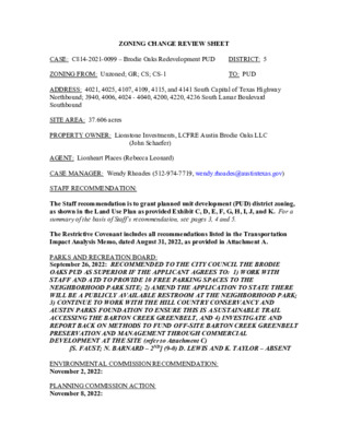
ZONING CHANGE REVIEW SHEET CASE: C814-2021-0099 – Brodie Oaks Redevelopment PUD DISTRICT: 5 ZONING FROM: Unzoned; GR; CS; CS-1 TO: PUD ADDRESS: 4021, 4025, 4107, 4109, 4115, and 4141 South Capital of Texas Highway Northbound; 3940, 4006, 4024 - 4040, 4200, 4220, 4236 South Lamar Boulevard Southbound SITE AREA: 37.606 acres PROPERTY OWNER: Lionstone Investments, LCFRE Austin Brodie Oaks LLC (John Schaefer) AGENT: Lionheart Places (Rebecca Leonard) CASE MANAGER: Wendy Rhoades (512-974-7719, wendy.rhoades@austintexas.gov) STAFF RECOMMENDATION: The Staff recommendation is to grant planned unit development (PUD) district zoning, as shown in the Land Use Plan as provided Exhibit C, D, E, F, G, H, I, J, and K. For a summary of the basis of Staff’s recommendation, see pages 3, 4 and 5. The Restrictive Covenant includes all recommendations listed in the Transportation Impact Analysis Memo, dated August 31, 2022, as provided in Attachment A. PARKS AND RECREATION BOARD: September 26, 2022: RECOMMENDED TO THE CITY COUNCIL THE BRODIE OAKS PUD AS SUPERIOR IF THE APPLICANT AGREES TO: 1) WORK WITH STAFF AND ATD TO PROVIDE 10 FREE PARKING SPACES TO THE NEIGHBORHOOD PARK SITE; 2) AMEND THE APPLICATION TO STATE THERE WILL BE A PUBLICLY AVAILABLE RESTROOM AT THE NEIGHBORHOOD PARK; 3) CONTINUE TO WORK WITH THE HILL COUNTRY CONSERVANCY AND AUSTIN PARKS FOUNDATION TO ENSURE THIS IS A SUSTAINABLE TRAIL ACCESSING THE BARTON CREEK GREENBELT, AND 4) INVESTIGATE AND REPORT BACK ON METHODS TO FUND OFF-SITE BARTON CREEK GREENBELT PRESERVATION AND MANAGEMENT THROUGH COMMERCIAL DEVELOPMENT AT THE SITE (refer to Attachment C) [S. FAUST; N. BARNARD – 2ND] (9-0) D. LEWIS AND K. TAYLOR – ABSENT ENVIRONMENTAL COMMISSION RECOMMENDATION: November 2, 2022: PLANNING COMMISSION ACTION: November 8, 2022: C814-2021-0099 Page 2 May 24, 2022: APPROVED AN INDEFINITE POSTPONEMENT REQUEST BY STAFF R. SCHNEIDER; J. THOMPSON – 2ND] (9-0) Y. FLORES, C. HEMPEL, J. MUSHTALER – ABSENT December 14, 2021: APPROVED AN INDEFINITE POSTPONEMENT REQUEST BY STAFF [A. AZHAR; R. SCHNEIDER – 2ND] (11-0) P. HOWARD – OFF THE DAIS; J. SHIEH – ABSENT CITY COUNCIL ACTION: December 1, 2022: ORDINANCE NUMBER: ISSUES: Austin Energy has requested that the Applicant dedicate a 1.5 acre site for an above-ground substation on the Property in order to address capacity limitations in the existing area. The Applicant has addressed Austin Energy’s specific comment and included major utility facilities as a permitted civic use within Land Area 2 on Exhibit C, but does not agree to dedicate a site. Correspondence received from representatives of the Austin Parks Foundation and the Hill Country Conservancy is attached at the back of this packet. EXHIBITS AND ATTACHMENTS TO THE STAFF REPORT: Exhibits A and A-1: Zoning Map and Aerial Exhibit B: Applicant’s Transmittal Letter, Tier One / Tier Two (Superiority) Chart, and Code Modification Table Exhibits to the PUD: Exhibit C: Land Use Plan Exhibit D: Parks and Open Space Plan Exhibit E: Transportation Plan Exhibit F: Water Quality and Environment Exhibit G: Grading Plan Exhibit H: Phasing Plan Exhibit I: Arts Master Plan Exhibit J: Water and Wastewater Plan Exhibit K: Existing Slope Map Attachment A: Transportation Impact Analysis Memo Attachment B: Environmental Commission support material (to be added) Attachment C: Parks and Recreation Board Recommendation Attachment D: Educational Impact Statement C814-2021-0099 Page 3 Attachment E: Carbon Impact Statement Correspondence Received CASE MANAGER COMMENTS: The Brodie Oaks Redevelopment PUD is located at the northwest corner of the South Capital of Texas Highway Northbound (aka Loop 360, also a Hill Country Roadway) and South Lamar Boulevard, a major arterial roadway with a Capital Metro MetroRapid Route 803 transit stop located near an existing driveway. The property contains a vacated section of TxDOT right-of-way (Unzoned) and a commercial shopping center surrounded by surface parking areas with community commercial, general commercial services and commercial- liquor sales zoning (GR, CS, CS-1). The Brodie Oaks shopping center was developed in 1981 and serves the south Austin area with retail spaces, restaurants, a grocery store, medical office, and fitness gym. The Barton Creek Greenbelt and trail is to the northwest (SF-2), apartments are to the northeast on South Lamar (MF-4, MF-2), and undeveloped (vacated) TxDOT right-of-way and a commercial shopping center with similar uses is to the southeast across South Lamar (CS-V, CS-1-V, CS-1-V-CO). Please refer to Exhibits A and A-1 – Zoning Map and Aerial Exhibit. PROJECT DESCRIPTION The Brodie Oaks Redevelopment PUD is proposed mixed use development that would consist of up to 1,700 residential units, 1,260,000 square feet of office, 200 hotel keys, 110,000 square feet of retail, and 30,000 square feet of restaurant uses. Three driveways to South Lamar are proposed (including one shared access) and two driveways are proposed to Loop 360. Internal circulation routes consist of private streets with public access easements. The proposed density is approximately 56 units per acre. The maximum height proposed is 275 feet at South Lamar and Loop 360 intersection, with three other lesser height limits on the remainder rof the South Lamar and Loop 360 frontage and interior portions of the property. Land Use Plan The PUD contains two land use areas: Land Use Area 1 (25.9 acres) and Land Use Area 2 (11.7 acres). • Land Use Area 1 is generally located along all of the South Lamar Boulevard frontage and most of the Loop 360 frontage, and is proposed to be developed with nearly all of the development described above, including residential and non- residential square footage, and hotel keys. A Central Green area is located in the center of the site and propose to include a performance pavilion. Height ranges from 160 feet at the northeast corner of the property to 275 feet at the South Lamar / Loop 360 intersection. • Land Use Area 2 is located along the northwest portion of the property adjacent to Barton Creek Greenbelt and is limited to 5,000 square feet of impervious cover. C814-2021-0099 Page 4 Height is limited to 28 feet and includes a portion of the Hill Country Roadway area. Please refer to Exhibit C – Land Use Plan. GENERAL TO PLANNED UNIT DEVELOPMENTS Per the Land Development Code, PUD district zoning was established to implement goals of preserving the natural environment, encouraging high quality, sustainable development and innovative design, and ensuring adequate public facilities and services. The City Council intends PUD district zoning to produce development that achieves these goals to a greater degree than and thus is superior to development which could occur under conventional zoning and subdivision regulations. The PUD provides a canvas for the design of a large scale project, with the end goal to allow flexibility, and also inform and communicate the possibilities for development. Additional effort is required by all parties to ensure that development standards are clear and municipal and citizen needs are addressed. The PUD ordinance and related exhibits are key because once approved, they provide the regulations under which the project will be built, which provides certainty for developers and their agents. City Council approved revisions to the PUD regulations that became effective June 29, 2008. To help evaluate the superiority of a proposed PUD, requirements are divided into two categories: Tier One, which is requirements that all PUDs must meet, and Tier Two which provides criteria in 13 topical areas in which a PUD may exceed Code requirements and therefore demonstrate superiority. A PUD need not address all criteria listed under Tier Two, and there is no minimum number of categories or individual items required. SUPERIORITY ELEMENTS As more fully detailed in the Tier Table and Land Use Plan, the proposed Brodie Oaks Redevelopment PUD meets all 12 of the applicable Tier One items and offers some elements of superiority in several of the 13 Tier Two categories and subcategories (Affordable Housing; Art; Great Streets Development Program; Green Building Program; Non- Protected Trees; Open Space; Protected Trees; Parking Structure Frontage; Primary Irrigation Source; Stormwater Runoff; Tree Species List; Trailhead along Creek or Waterways, Transportation; Water Quality Treatment – Off-site; Water Quality Treatment – On-site). Please refer to Exhibit B – Superiority Chart. The proposed PUD offers a development on the subject property that creates a distinct community and gateway to south Austin. The PUD provides a pedestrian-oriented development that promotes living, including affordable housing initiatives, working and shopping opportunities, as well as accessible open space and connected trail improvements within a planned community. The corresponding Traffic Impact Analysis memo provides for a suite of transportation improvements needed to accommodate the additional density, including 1) improvements to roadway infrastructure (reconstruction of the Brodie Oaks driveway and South Lamar intersection; construction of a dedicated right-turn lane in to the site at the driveway on the Loop 360 frontage road); 2) improvements to transit (incorporating the southbound Brodie Oaks Station stops into the site design per the South Lamar Boulevard corridor plan), and 3) C814-2021-0099 Page 5 improvements to active pedestrian and bicycle infrastructure to address gaps (including construction of a 12-foot wide shared use path along the south / west side of the private road connecting the development to the adjacent office complex; construction of all South Lamar Boulevard corridor improvements along the property frontage, including sidewalks and protected bicycle lane; and construction of sidewalks, crosswalks, curb ramps, and stamped concrete to provide pedestrian routes across the west and east sides of the South Lamar Boulevard and US 290 frontage roads intersection. Given the number and breadth of items offered in the PUD that exceed current code standards, Staff believes the proposal can result in superior mixed use development. The following factors make this project superior: Affordable Housing • A stand-alone affordable housing site (roughly estimated at 1.5 acres) is located at the northeast corner of the site (an existing restaurant pad site), to be constructed in Phase II of the development, as shown on Exhibits C and H. The site is adjacent to a planned neighborhood park, along the South Lamar frontage and adjacent to the planned transit stop. The base height used to calculate affordable housing bonus area is based on the maximum height allowable under the current zoning, including applicable overlays. • Residential Bonus Area: To the extent that any residential buildings exceed the base heights established on Exhibit C, the Landowner shall provide contract commitments and performance guarantees that provide affordable housing meeting or exceeding the requirements of Section 2.5.3 (Requirements for Rental Housing) or Section 2.5.4 (Requirements for Ownership Housing) equal to 10 percent of the total amount of occupiable square feet which exceeds the established base height. Such calculation shall be made for each building at the time a building permit is issued. • Phasing of Residential Bonus Area: In recognition that some buildings will contain more residential units than others, such obligation may be transferred between buildings as they come on line as long as the number of units never falls below the required obligation. The total residential affordable housing square foot obligation shall be tracked on each site plan in accordance with Exhibit H – Phasing Plan. • Non-Residential Bonus Area: To the extent that any non-residential buildings exceed the base height, the developer shall convey land to a non-profit organization for a stand-alone, family-oriented affordable housing project built on-site that must include a minimum of 125 units with a mix of 2 and 3-bedroom units, and is affordable to a household whose income is between 30 and 60% of the MFI in the Austin metropolitan statistical area, remain affordable for 40 years from the date a Certificate of Occupancy is issued, and be eligible for federal housing choice vouchers. • The affordable housing requirement for non-residential bonus area will be satisfied through the recordation of a land use restriction with the deed to restrict the site (Block 4) to an affordable housing project. The restrictive covenant will be subject to the existing retail lease to the restaurant. If the non-profit organization is unable to C814-2021-0099 Page 6 develop the family-oriented project, then the City will still have the commitment that an alternative affordable housing project will be constructed. Art • The Brodie Oaks Redevelopment PUD shall participate in the Art in Public Places Program. As shown in Exhibit I, the Arts Master Plan identifies opportunities and locations within the PUD for outdoor art installations to be implemented and managed by the Landowner. The Arts Master Plan shall consist of a minimum of two (2) significant art pieces. Austin Energy – Green Building • All buildings in the Brodie Oaks Redevelopment PUD shall achieve a three-star or greater rating under the Austin Energy Green Building program using the applicable rating version in effect at the time a rating registration application is submitted for the building. Austin Fire Department The Applicant has worked with AFD and ATCEMS to provide a new fire and EMS station to serve this new development and the surrounding area. The fire and EMS station will be located within a mixed-use building and provide better access to the Barton Creek Greenbelt including the potential for search and rescue staging areas. • The Landowner shall provide a 9,000 to 11,000 SF unfinished space within the level of discharge (“ground floor”) and floor above of a building located upon Block 6, Block 8, or Block 9 to be used as a Fire/EMS station as shown in Exhibit C (Page 5). The Fire/EMS station shall include a private convenience stair, an external wall, adequate space on the level of discharge for apparatus bays and appropriate apron for Fire/EMS apparatus, and adhere to Austin Fire Department (AFD) and Austin-Travis County EMS (ATCEMS) design standards. • The unfinished space will be provided at no rental cost to AFD/ATCEMS in a 40- year building lease with a unilateral 40 year right to renew. Any foreclosure or sale of the building will require the lender or buyer to honor the lease. Ongoing costs of operating the space (utilities, maintenance, repair, etc.) will be at the expense of AFD/ATCEMS. All property taxes and building overhead costs will be at the expense of the building owner, unless the space is conveyed to the City of Austin in lieu of a lease. AFD/ATCEMS will be permitted to operate, use, and maintain necessary facilities and equipment as needed to conduct daily operations. • Final selection of the location must be approved by the Austin Fire Department, Austin-Travis County EMS, the Development Services Department, and the Developer. Every effort will be made to provide access at a controlled intersection, with a preference for direct access to Lamar Blvd. The location will be finalized prior to the submission of any building permit applications beyond those representing a cumulative total of 40% of all building square footage within the entire Brodie Oaks Redevelopment PUD development. The lease will be executed and/or the space will C814-2021-0099 Page 7 be conveyed prior to 55% of certificates of occupancy for the development having been issued. Austin Water Utility • The project will capture and beneficially reuse all rooftop rainwater from the water quality event for beneficial use in cooling towers and traditional landscape irrigation. • The building will provide low-flow and efficient fixtures to reduce demand beyond minimum requirements in the Austin Energy Green Building star rating system. • The project is subject to the AC condensate beneficial use requirement (UMC 310.8) and therefore will capture and beneficially use condensate generated on site to supply any non-potable demand available to the maximum extent practicable. Great Streets • The project will provide a 25-foot wide Clear Zone across the street section of pedestrian and raised bicycling space, as shown in Exhibit E – Transportation Plan. • The project will provide a 21-foot wide across the street section and three planting zones. • All utilities will be underground. Non-Protected Trees (Up to 18.9 caliper inches) • The project will preserve up to 77 percent of all trees meeting preservation criteria that are up to 18.9 caliper inches. Open Space • The project will provide 11.6 acres of open space as shown on Exhibit D – Parks and Open Space Plan (equivalent to 45% of the developed area). In addition, nearly 8.1 acres of open space is located adjacent to the Barton Creek Greenbelt creating a 100’ – 300’ buffer between the Greenbelt and the proposed development. Parking Structure Frontage • At least 75 percent of the building frontage of all parking structures along the internal circulation route will be designed for pedestrian-oriented uses. Special treatments such as false facades, vertical art or green walls will be utilized on parking garages visible from Loop 360 and South Lamar Boulevard. Protected Trees (19 – 23.9 caliper inches) • The project will preserve up to 79 percent of all protected trees meeting preservation criteria that are up to 23.9 inches. This includes the relocation of 10 trees into the newly created parkland onsite. Brodie Oaks Redevelopment PUD is also committed to implementing a tree care plan identified in the Arborist report to maintain the health of trees that are planned to be preserved in the ultimate development. C814-2021-0099 Page 8 Primary Irrigation Source • A rooftop rainwater harvesting system will serve not less than 50 percent of the landscaped areas where irrigation is required. Stormwater Runoff • Rooftop rainwater and AC condensate wastewater will be collected for reuse in traditional landscaping irrigation purposes and cooling tower makeup water. Trailhead along Creek or Waterways • The project will provide a formal and universally accessible trailhead to the Barton Creek Greenbelt and Violet Crown Trail, including trail access, wayfinding, and interpretive materials, as well as access to parking and restrooms. • The project will provide a series of bicycle facilities for all types of users along the internal circulation route and will provide a shared use path adequate for recreational cycling that will connect through the site and to off-site trail networks. • The project will provide pedestrian and bicycle connection to adjacent residential Transportation development. Tree Species List Water Quality Treatment (Off-site) will not drain off-site. Water Quality Treatment (On-site) • The project will use Central Texas native seed stock with adequate soil volume. • The project will implement water quality treatment facilities so that impervious cover • One hundred (100) percent of the water quality volume will use green stormwater controls which will include all or some of the following methods: retention / irrigation, retention / infiltration, cooling tower makeup water, conventional irrigation. CODE MODIFICATIONS There are numerous modifications to Code requirements (43) requested by the Applicant and recommended by Staff. As summarized below, these include Code definitions (3), and requirements for Zoning (24), Subdivision (2), Site Plan (3), Transportation and the Transportation Criteria Manual (4), Environment and the Environmental Criteria Manual (6), and the Drainage Criteria Manual (1). Please refer to Exhibit B – Code Modification Table. The proposed modifications to the Brodie Oaks Redevelopment PUD and accompanying land use plan are summarized below: C814-2021-0099 Page 9 General Zoning Section 25-1-21 (Definitions) – Modification: Block means one or more lots, tracts, or parcels of land bounded by streets (public or private), 30’ wide or larger pedestrian paseo or courtyard with a minimum 12’ sidewalk or trail, public or private park space / open space easement or plaza space, railroads, or subdivision boundary lines. 25-1-21 (Definitions) – Modification: Gross floor area is modified to include parking structures. 25-1-21 (105) (Definitions) – Addition: A site within the Brodie Oaks Redevelopment PUD boundary may cross a private street with public access easements. Remove – 25-2, Subchapter B, Article 2, Subpart C, Section 3.2.2 (C) (Residential Uses) does not apply to the Brodie Oaks Redevelopment PUD. Remove – 25-2, Subchapter B, Article 2, Subpart C, Section 3.2.3 (B) (Non- Residential Uses) does not apply to the Brodie Oaks Redevelopment PUD. Modification – 25-2, Subchapter B, Article 2, Subpart C, Section 3.2.3 (D) (Non- Residential Uses) is modified so that the minimum front yard and street side yard setbacks apply as shown in Exhibit C – Land Use Plan. Modification – 25-2, Subchapter B, Article 2, Subpart B, Section 2.5.2. (B) (2) (Requirements for Exceeding Baseline) is modified for developments with no residential units, either provide contract commitments and performance guarantees that provide affordable housing meeting or exceeding the requirements of Section 2.5.3 (Requirements for Rental Housing) and Section 2.5.4 (Requirements for Ownership Housing) within the boundaries of the Brodie Oaks Redevelopment PUD. Section 25-2-491 (Permitted, Conditional, and Prohibited Uses) – Modification – Exhibit C establishes the permitted, conditional, and prohibited uses of the Property. Section 25-2-492 (Site Development Regulations) – Modification – Exhibit C establishes the principal site development regulations applicable to the Property. Section 25-2, Subchapter E, Section 2.2.1.B – Modification – The priority street for the Brodie Oaks Redevelopment PUD is the Internal Circulation Route. The sentence “If the roadways do not have transit service or the level of transit service is equal, the roadway is designated by the lot owner” does not apply. Section 25-2, Subchapter E, Section 2.2.1.B – Modification – For large sites subject to Section 2.2.5 or for sites abutting more than one roadway type, the Sidewalk and Supplemental Zone requirements (but not the Building Placement and Parking Requirements) shall apply along the Internal Circulation Route frontages, with the applicable requirements determined by the roadway type. C814-2021-0099 Page 10 Section 25-2, Subchapter E, Section 2.2.2B 1 – Modification – The planting zone shall have a minimum width of seven (7) feet from face of curb) and shall be continuous and located adjacent to the curb or cycle track. Section 25-2, Subchapter E, Section 2.2.5 C – Modification – The perimeter of a block is defined by private streets with a public access easement, public streets, and public open spaces that include a pedestrian path. The maximum length of any block shall be 800 feet. Section 25-2, Subchapter E, Section 2.2.5 G – Modification – If the Internal Circulation Route is intended to accommodate bicycles, head in and angle parking is not permitted except when the cycle tract is provided between the clear zone and the head-in or angle parking. Section 25-2, Subchapter E, Section 2.2.5 G – Modification to add: A residential use or amenity space for residential uses may occupy a space that is designed for commercial uses. Modification to remove and add: A lobby serving another use in a VMU building shall not count as a pedestrian-oriented commercial use for the purposes of this section if it is designed to meet the standards of this section. Remove: The requirement that a front façade that meets the glazing requirements of Section 3.2.2 does not apply. Section 25-2, Subchapter E 4.3.3. F. – Modification – To be eligible for the dimensional or parking standards exemptions in Subchapter E of this section, the residential units in the Brodie Oaks Redevelopment PUD shall meet the affordability requirements identified in the Superiority item. Section 25-2-1104 (Hill Country Roadway Overlay Exceptions) – Addition – This article applies to the Brodie Oaks Redevelopment PUD and designated Land Use Areas as specifically indicated in this Code Modification section and as represented in Exhibit C. Section 25-2-1122 (Floor-to-Area Ratio of a Nonresidential Building) – Addition – This section does not apply to the Brodie Oaks Redevelopment PUD. Section 25-2-1123 (Construction on Slopes) – Addition – This section does not apply to property in Land Use Area 2 of the Brodie Oaks Redevelopment PUD. Section 25-2-1124 (Building Height) – Addition – (D) The height of a building within the Brodie Oaks Redevelopment PUD will comply with Exhibit C. Section 25-2-1126(A) (Building Materials) – Modification – Each building shall be designed to use, to the greatest extent feasible, building materials that are compatible with the environment of the Hill Country, including rock, stone, brick, and wood on the ground floor of a building in the Brodie Oaks Redevelopment PUD. C814-2021-0099 Page 11 Section 25-2-1022 (B) (Native Trees) – Modification – A site plan within the Hill Country Roadway ordinance area for the Brodie Oaks Redevelopment PUD must preserve all Heritage and Protected Trees identified as suitable in the Arborist Report submitted with this PUD and compensate for the removal of the following native or small native trees at a rate of 60 percent: (1) each small native tree; (2) each native tree with a trunk diameter greater than six (6) inches; and (3) each cluster of three or more native trees located within ten (10) feet of each other with trunk diameters greater than two (2) inches. Section 25-2-1023 (Roadway Vegetative Buffer) – Modification – Except in the Brodie Oaks Redevelopment PUD and as otherwise provided by this section, vegetation within 100 feet of the dedicated right-of-way may not be cleared, unless the clearing is necessary to provide utilities and access to the site. Section 25-2-1024 (C) (Restoring Roadway Vegetative Buffer) – Addition – In the Brodie Oaks Redevelopment PUD, revegetation of the Roadway Vegetation Buffer will be consistent with the commitments made in Exhibit C. Section 25-2-1025 (E) (Natural Area) – Addition – Within Land Use Area 2 of the Brodie Oaks Redevelopment PUD, representing at least 45 percent of the Hill Country Roadway Overlay (HCRO) Area, existing surface parking, perimeter walls, and buildings will be removed and two (2) acres or 12 percent of the total area within the HCRO area will be restored to meet the Revegetation Standards outlined in Exhibit C. Section 25-2-1026 (Parking Lot Medians) – Modification – A permanent parking lot must have a median at least ten (10) feet wide containing existing native trees or dense massing of installed trees between each distinct parking area. Section 25-2-1027 (Visual Screening) – Modification – Visual screening required by this article is not required in Land Use Area 1. Visual screening in Land Use Area 2 must: (1) use existing vegetation or installed landscaping; (2) include dense massing of trees, native understory vegetation, shrub massing, or berms; and (3) allow for topographic changes. Section 25-4-62 (Expiration of an Approved Preliminary Plan) – Modification – An approved preliminary plan expires seven (7) years after the date the application for approval of the preliminary plan is submitted. Section 25-4-411 (A) (Access to Lots) – Modification – Each lot in a subdivision shall abut a dedicated public street, or a private street with public access easement or Internal Circulation Route. Subdivision C814-2021-0099 Site Plan Page 12 Section 25-5-81 (B) (Expiration of an Approved Preliminary Plan) – Modification – Except as provided in Subsections (C), (D), and (E) of this section, a site plan expires eight (8) years after the date of its approval. Section 25-5-21 (B) (Phased Site Plan) – Modification – The director may approve development phasing if the date proposed for beginning construction on the final phase is not more than five (5) years after the approval of the site plan. Planning Commission approval is required for development phasing if the date proposed for beginning construction of a phase is more than five (5) years after approval date of the site plan. Section 25-5-142 (Land Use Commission Approval) – Modification – Land Use Commission approval of site plan is required for: (1) a conditional use; (2) except for the Brodie Oaks Redevelopment PUD and as provided in Section 25-5-2 (Site Plan Exemptions), development in a Hill Country Roadway Corridor; and (3) if otherwise required by this title. Transportation Section 25-6-411 (Access to Hill Country Roadways) – Modification – Applicability: This division applies to property located in a hill country roadway corridor and within the zoning jurisdiction of the City with the exception of the Brodie Oaks Redevelopment PUD. Sections 25-6-477, 25-6-478, 25-6-532, and Appendix A (Off-Street Parking and Loading) – Addition – The minimum off-street parking, bicycle parking, and loading requirements shall be determined by the Director subject to a Transportation Demand Management (TDM) Plan approved as part of the Brodie Oaks Redevelopment PUD. Section 25-6-473 (Modification of Parking Requirements) – Addition – In the Brodie Oaks Redevelopment PUD, for a site plan that complies with a TDM Plan and the site’s approved Traffic Impact Analysis, the minimum off-street parking requirement is 60 percent of that prescribed by Appendix A (Tables of Off-Street Parking and Loading Requirements). Transportation Criteria Manual 1.3.1 (A) General Design Criteria - Grades – Addition – Existing streets that do not meet the standards for maximum grade may be improved as described in Exhibit E – Brodie Transportation Plan. Environment Environmental Criteria Manual (ECM) 1.6.7.5 (D) – Modification – to provide options for cooling tower makeup water and a design option for beneficial reuse. Option C – Captured runoff for beneficial reuse. This option proposes to capture rooftop rainwater from each building for reuse as traditional landscape irrigation and cooling tower makeup water. The rooftop rainwater will be collected in subsurface tank(s) and treated downstream of storage with filtration and potentially ultraviolet light for specific applications prior to use. The Landowner may achieve compliance C814-2021-0099 Page 13 through Section 25-8-151 (Innovative Management Practices) for innovative water quality controls as a practice that is not specifically prescribed in the ECM, but is designed to address the requirements of Article 6 (Water Quality Controls), subject to review and approval by the Watershed Protection Department. Results will be modeled to demonstrate a reduction in pollutant load from the predeveloped condition in accordance with the Save Our Springs requirements. Residence and drawdown times may differ from typical ECM requirements based on technical merit, resource protection and improvement, and advantages over standard practices. Real time controls may be used to improve the runoff capture efficiency and optimize beneficial reuse. Section 25-8-341 (Cut Requirements) – Modification – Cuts on a tract of land may not exceed a minimum of 14 feet as shown on Exhibit G – Grading Plan. Section 25-8-342 (Fill Requirements) – Modification – Fill on a tract of land may not exceed 14 feet as shown on Exhibit G – Grading Plan. Section 8-514 (A) (SOS Ordinance, Pollution Prevention Required) – Modification – In order to prevent pollution, impervious cover for the Brodie Oaks Redevelopment PUD shall be limited to a maximum of 56 percent Net Site Area. Please note that this is covered as a separate agenda item. Section 25-8-281 (A) (Critical Environmental Features) – Addition – The Brodie Oaks Redevelopment PUD will be permitted to encroach on Airman’s Cave a maximum of 80 feet provided there is a minimum of 20 feet of Del Rio Clay remaining between any encroachment into the CEF buffer and the vertical extent of the cave. In addition, the Brodie Oaks Redevelopment PUD is permitted to encroach 50 feet into the spring labeled as 5-1 as shown on Exhibit F – Water Quality and Drainage Plan (Page 2). Drainage Criteria Manual Section 5.3.2 (Maximum Velocities) – Addition – The Brodie Oaks Redevelopment PUD will be permitted to exceed 20 feet per second for the 25-year event for Storm drain trunks with a proposed velocity of 21.6 feet per second. EXISTING ZONING AND LAND USES: Site ZONING Unzoned; GR; CS; CS-1 Northwest SF-2 Southeast CS-V; CS-1-V LAND USES Vacated TxDOT right-of-way; Commercial shopping center: financial services, food sales, indoor sports and recreation, medical office, personal services, restaurants, retail sales Barton Creek Greenbelt and trail Vacated TxDOT right-of-way; Commercial shopping center: financial services, food sales, hospital services C814-2021-0099 Page 14 Northeast MF-4 Southwest Not applicable (limited), indoor sports and recreation, medical office, personal services, personal improvement services, restaurants, retail sales Apartments South Capital of Texas Highway Northbound frontage road and main lanes (Loop 360) SCENIC ROADWAY: Yes, Loop 360 NEIGHBORHOOD PLAN AREA: South Lamar Combined (Barton Hills) (Suspended) TRANSPORTATION IMPACT ANALYSIS: Is required – Please refer to Attachment A. WATERSHED: Barton Creek Watershed – Barton Springs Zone CAPITOL VIEW CORRIDOR: No HILL COUNTRY ROADWAY: Yes, Loop 360 – High Intensity SCHOOLS: An Educational Impact Statement is required. Please refer to Attachment D. Barton Hills Elementary School O. Henry Middle School Austin High School COMMUNITY REGISTRY LIST: 381 – Barton View Neighborhood Association 498 – South Central Coalition 742 – Austin Independent School District 1107 – Perry Grid 614 1363 – SEL Texas 1429 – Go Austin Vamos Austin 78745 1531 – South Austin Neighborhood Alliance (SANA) 1550 – Homeless Neighborhood Association 1596 – TNR - BCP Travis County Natural Resources 1616 – Neighborhood Empowerment Foundation 1714 – East Oak Hill Neighborhood Association 1774 – Austin Lost and Found Pets 1795 – Westgate Neighborhood Plan Contact Team AREA CASE HISTORIES: 384 – Save Barton Creek Assn. 511 – Austin Neighborhoods Council 943 – Save Our Springs Alliance 1424 – Preservation Austin 1530 – Friends of Austin Neighborhood 1228 – Sierra Club, Austin Regional Group REQUEST Unzoned; CS to CS-V COMMISSION CITY COUNCIL To Grant CS-V NUMBER C14-2020-0149 – 4215 S Lamar Blvd and 2428 W Ben White Blvd WB C14-2018-0094 – 2432 W Ben White Boulevard Service Unzoned to CS To Grant CS Apvd CS-V as Commission recommended (7-29-2021). Apvd CS as Commission recommended C814-2021-0099 Page 15 CS-V to CS-1-V To Grant CS-V-CO w/CO for list of prohibited uses To Grant adding (V) to various tracts (11-15-2018). Apvd CS-V-CO as Commission recommended (12-8-2016). Apvd adding (V) as Commission recommended (6-18-2008). To Grant adding (V) to various tracts Apvd adding (V) as Commission recommended (6-18-2008). Road Westbound C14-2016-0091 – ASC / Bearcreek Properties – 4001 S Lamar Blvd C14-2008-0019 – South Lamar Neighborhood Planning Area Vertical Mixed Use Building (V) Zoning Opt-In/ Opt-Out C14-2008-0043 – Barton Hills Neighborhood Planning Area Vertical Mixed Use Bldg (V) Zoning Opt-In/ Opt-Out To add -V (Vertical Mixed Use) zoning to various properties. To add -V (Vertical Mixed Use) zoning to various properties. RELATED CASES: The Development Assessment for a PUD was filed on December 21, 2020l and Staff conducted a briefing to the Environmental Commission on March 3, 2021 and to Council on March 23, 2021 (CD-2020-0002). The Applicant filed the PUD zoning application on December 21, 2021. There is a related Restrictive Covenant Amendment application in process to amend the maximum height limits as it pertains to Lots A, B, C, and D to allow for the proposed mixed use project (C14R-81-033(RCA)). The Restrictive Covenant Amendment requires the approval of the adjacent property owners within the Covenant area prior to final Council approval. On October 13, 2022, Council approved a Resolution initiating site-specific amendments to City Code Chapter 25-9, Subchapter A, Article 13 (Save Our Springs Initiative) as minimally required to address development related to the proposed Brodie Oaks Redevelopment PUD. EXISTING STREET CHARACTERISTICS: Name Pavement Classification Sidewalks ROW South Lamar Boulevard 230’ – 1,800’ Varies, divided Level 4 Yes Bicycle Route Shared Lane Capital Metro (within ¼ mile) Yes C814-2021-0099 Page 16 Yes Yes No Yes 350’ 154’ Varies Level 4 Level 4 Shared Lane Shared Lane Varies, divided South Capital of Texas Highway Northbound West Ben White Boulevard ADDITIONAL STAFF COMMENTS: Site Characteristics The property contains a commercial shopping center and parking lot, with sparse vegetation. Topography is flat to slightly sloping. Surface elevations range from approximately 664 to 712 feet above mean sea level with surface water flowing from south to north toward Barton Creek. Inclusive Planning The proposed PUD is located on the northeast corner of Capital of Texas Highway and South Lamar Boulevard, on an approximately 37.61-acre site, that currently contains a variety of commercial and retail uses, including a grocery store, retail and office uses, restaurants and a Hobby Lobby. The property consists of multiple address points, is located within the boundaries of an Activity Center for Redevelopment in Sensitive Environmental Areas (Lamar & Ben White) and along the South Lamar Activity Corridor. This rezoning case is not located within the boundaries of an adopted small area plan. Surrounding land uses include the Barton Creek Greenbelt and Trail and an apartment complex to the north; to the south is a shopping center; to the east is an apartment complex and commercial uses; and to the west is the Barton Creek Greenbelt, an office building and commercial uses. The development proposal calls for clearing the site and “transforming it from a suburban shopping center and surface parking lots to a compact, vibrant, transit-oriented, and mixed- use center that includes 13.2 acres of new publicly accessible open space (which is 35 percent of the site and 5 times the amount of greenspace required under Tier 2) with views of the downtown skyline and Hill Country forming a new gateway to the Barton Creek Greenbelt.” Specifically, this project proposes approximately 1,233 mid-rise multifamily residential units, 467 high-rise dwelling units (up to 275 feet tall), 1,260,000 square feet of office space, 200 hotel rooms, 140,000 square feet of retail and restaurant uses located along private streets with public access easements including an Internal Circulator Route meeting Great Streets standards with activated ground floor uses. The following points are taken from the applicant’s rezoning application highlighting some of the proposed improvements and features of the planned project: • Reposition the retail environment from single-use, auto-oriented to mixed-use and walkable will align the physical environment with the social and environmental trends. The density and height proposed for the Brodie Oaks Redevelopment enable the project to meet the vision established in Imagine Austin Comprehensive Plan of C814-2021-0099 Page 17 an “Activity Center for Redevelopment in Sensitive Environmental Areas” including state-of-the-art development practices to improve stormwater retention and water quality flowing into the Edwards Aquifer Recharge Zone and Barton Creek Zone. The Brodie Oaks Redevelopment will provide an environmentally superior project that complies with the SOS Water Quality Standards. Reducing impervious cover from 84 percent to 54 percent, complying with SOS water quality standards. Eliminate nearly 4 acres of untreated runoff from buildings and parking currently draining directly into the Barton Creek Greenbelt. The proposed plan will allow only water from open space to leave the site. Plant native or native adaptive trees and vegetation and be committed to a Tree Health and Maintenance Plan. Save or move the many of the heritage trees on the site. • Restore over 25 percent of the site to open space adjacent to the Barton Creek Greenbelt, which is made possible through building up to 275’ tall along the Loop 360 and S. Lamar Boulevard frontage. • All buildings will have direct pedestrian connections from entrance to adjacent streets. Provide shade trees or shade structures along all streets. The Brodie Oaks Redevelopment provides transit-supportive densities within walking distance of the high-capacity MetroRapid Route 803 transit stop as called for in Imagine Austin. Discuss the coordination of a Purple Line high capacity MetroRapid Route 803 transit stop. A shared parking strategy and a travel demand management plan is included in PUD Submission 1. • Create a shared-use path of approximately 2,500 linear feet extending from S. Lamar Boulevard to Park Road that will run along the park’s edge and be used for mobility and recreation uses. Constructing a designated trailhead and connection to the Barton Creek Greenbelt with signage, trash disposal and parking. Provide a network of active trails, public sidewalk, and install a publicly accessible trailhead into the Barton Creek Greenbelt. C814-2021-0099 Page 18 • At least 80 percent of the parking will be underground or in parking structures. Shared parking and travel demand management strategies will reduce reliance on single-occupancy vehicles. The project will also provide a network of up to 6,000 feet of active trails, 10,000 feet of sidewalk, and an intentional trailhead to the Barton Creek Greenbelt and Violet Crown Trail including trail access, wayfinding, and interpretive materials, as well as access to parking and restrooms. Restore and transform approximately 21-acres acres of surface parking lots and drive aisles and approximately 8-acres of single use office and retail buildings to a vibrant neighborhood and destination for South Austin. • Provide a bike share station, bike parking, lockers, and showers. Pedestrian and bicycle access and connectivity strategies include the funding or construction of pedestrian and bicycle amenities and infrastructure on roadways and at intersections that people would use to access the Project site. Examples of pedestrian and bicycle access and connectivity features include bike lanes, bike boxes, sidewalks, curb ramps, crosswalks, bicycle signal heads, and pedestrian-hybrid beacons. • Designate 10 percent of the ‘bonus’ area of both residential and non-residential square footage for affordable housing on-site regardless of ownership or rent. • Buildings will meet LEED and WELL Building and Community standards to ensure health and well-being on the site. • Commit to the installation of a minimum of two art installations from local artists and the incorporation of performance venues. A central green will be developed and programmed for events and entertainment acting as the central core of food and beverage options. Parkland dedication will be met through private, but publicly accessible parks that enlarge Gus Fruh Park. The remainder of the parkland dedication requirement will be paid with fee-in-lieu. Use creative design and the incorporation of public art and performance venues. Biophilic design, energy and water conservation and the use of regional architectural styles and materials will all help contribute to the South Austin character. • Waive compatibility standards triggered by the Barton Creek Greenbelt's SF-2 Zoning. The current plat contains a scrivener’s error restricting residential uses on a portion of the site. A plat amendment to address this error was submitted concurrently with the PUD application. Connectivity This site is adjacent to CapMetro’s Metro Rapid Route 803, along the South Lamar Imagine Austin Corridor. Per the applicant’s agent: “The Brodie Oaks Redevelopment will support ridership on Capital Metro’s existing high capacity transit route (MetroRapid Route 803) on S. Lamar Boulevard with the development of a high-density, mixed-use project. Shared parking and travel demand management strategies will reduce reliance on single-occupancy vehicles.” Existing mobility and connectivity options in and around the site are below average and considered unsafe for pedestrians. C814-2021-0099 Page 19 Imagine Austin The Imagine Austin Growth Concept Map identifies this property as being near one of the five Activity Center for Redevelopment in Sensitive Environmental Area as identified on the Imagine Austin Growth Concept Map, found in the Image Austin Comprehensive Plan (IACP). Page 106 of the IACP states, “Five centers are located over the recharge or contributing zones of the Barton Springs Zone of the Edwards Aquifer or within water- supply watersheds. These centers are located on already developed areas and, in some instances, provide opportunities to address long-standing water quality issues and provide walkable areas in and near existing neighborhoods. State-of-the-art development practices will be required of any redevelopment to improve stormwater retention and the water quality flowing into the aquifer or other drinking water sources. These centers should also be carefully evaluated to fit within their infrastructural and environmental context”. One of the Land Use and Transportation policies, LUT P21 (page 102), clarifies the intent, “Ensure that redevelopment in the Edwards Aquifer’s recharge and contributing zones maintains the quantity and quality of recharge of the aquifer.” Activity Centers are supposed to be walkable, bikeable, and supported by transit. The property is also located along the South Lamar Activity Corridor. Activity Corridors are intended to allow people to reside, work, shop, access services, people watch, recreate, and hang out without traveling far distances. They are characterized by a variety of activities and types of buildings located along the roadway - shopping, restaurants and cafés, parks, schools, single-family houses, apartments, public buildings, houses of worship, mixed-use buildings and offices. The following IACP policies are also applicable to this rezoning case: • LUT P1. Align land use and transportation planning and decision-making to achieve a compact and connected city in line with the growth concept map. • LUT P3. Promote development in compact centers, communities, or along corridors that are connected by roads and transit that are designed to encourage walking and bicycling, and reduce health care, housing and transportation costs. • LUT P5. Create healthy and family-friendly communities through development that includes a mix of land uses and housing types and affords realistic opportunities for transit, bicycle, and pedestrian travel and provides both community gathering spaces, parks and safe outdoor play areas for children. Based upon the proposed project’s Superiority Table stating it will meet or exceed a variety of environmental standards, improve connectivity and mobility options in the area, add cultural amenities, and provide an affordable housing component, this PUD appears to support the Imagine Austin Comprehensive Plan policies. C814-2021-0099 Page 20 C814-2021-0099 Page 21 Drainage The developer is required to submit a pre- and post-development drainage analysis at the subdivision and site plan stage of the development process. The City’s Land Development Code and Drainage Criteria Manual require that the Applicant demonstrate through engineering analysis that the proposed development will have no identifiable adverse impact on surrounding properties. Impervious Cover The existing amount of impervious cover on the Brodie Oaks site is approximately 84% and the Applicant proposes to reduce the maximum impervious cover to 56% of the net site area and comply with SOS ordinance standards for non-degradation of water quality. Impervious cover will be tracked by site plan in compliance with Exhibit H – Phasing Plan and will be higher on a site-by-site basis. Modification of the maximum impervious cover allowed by the SOS Ordinance results in a Code amendment and is posted as a separate agenda item. A supermajority vote of the City Council is required. Environmental Office – Watershed Protection Department Please refer to Attachment B. Environmental Review – Development Services Department Please refer to Attachment B. Floodplain: 37.6-acre redevelopment site at S Lamar Blvd and US290/Loop360 in the Barton Creek watershed. Proposed redevelopment is not making improvements in the floodplain; as such no defined floodplain exists on the property since drainage area less than 64 acres. No floodplain review required for this case based on submitted documents. Comments below are standard FYIs. FYI: As the PUD does not request changes or amendments to floodplain code and criteria, all future applications in the PUD area will be required to meet floodplain regulations in effect at the time of application including but not limited to: prohibition of new buildings and parking located in the floodplain, requirements to demonstrate that all proposed development activities located within the floodplain do not adversely impact the floodplain on other property and all other floodplain regulations. FYI: Our understanding of flood risk in Austin is changing. What is now known as the 500- year floodplain is a good representation of what the 100-year floodplain will be according to a National Weather Service publication called Atlas 14. This could affect the layout of this development, including the location of lots, drainage easements, buildings, parking, and C814-2021-0099 Page 22 roadways. The City will likely be using the current 500-year floodplain as the design floodplain for residential and commercial building permit review in the near future. In order to minimize flood risk to our community and better ensure that all the lots in this PUD can be developed in the future, the City of Austin recommends that you consider the 500-year floodplain as a surrogate for the 100-year floodplain when designing this development within the PUD area. Office of Sustainability: The Brodie Oaks Redevelopment Superiority Table submitted with the PUD application outlines strategies to incorporate many of the elements in the Carbon Impact Statement (CIS), including: • Location of transit on the adjacent Lamar Blvd • Creating of bicycle facilities • Creating a walkable landscape with access to trails • Provide showers and indoor bicycle parking • Location in an Imagine Austin activity center or corridor. Please refer to Attachment E. Transportation Austin Water Utility A traffic impact analysis is required and has been received. Additional right-of-way, participation in roadway improvements, or limitations on development intensity may be recommended based on review of the TIA [LDC, Section 25-6-142]. Please refer to Attachment A. The Brodie Oaks PUD submitted a completed version of Austin Water’s Water Balance Calculator tool to assess non-potable demands and determine available alternative water supplies for the development. The Brodie Oaks PUD shall use alternative water sources, either onsite sources or municipal reclaimed water, within the development for all non-potable uses such as irrigation, cooling and toilet/urinal flushing applications. FYI: Service Extension Requests 4969 and 4970 are currently in review and must be approved prior to formal development plan approval per Utilities Criteria Manual 2.5.1(F)(13). For status, contact Katie Frazier at (512)-972-0232 or Katie.Frazier@austintexas.gov. FYI: The landowner intends to serve the site with City of Austin water and wastewater utilities. The landowner, at own expense, will be responsible for providing any water and wastewater utility improvements, offsite main extensions, water or wastewater easements, utility relocations and/or abandonments required by the proposed land uses. It is recommended that Service Extension Requests be submitted to Austin Water (AW) at the C814-2021-0099 Page 23 early stages of project planning. Water and wastewater utility plans must be reviewed and approved by Austin Water in compliance with Texas Commission on Environmental Quality rules and regulations, the City’s Utility Criteria Manual, and suitability for operation and maintenance. All water and wastewater construction must be inspected by the City of Austin. The landowner must pay the City inspection fees with the utility construction. The landowner must pay the tap and impact fee once the landowner makes an application for a City of Austin water and wastewater utility tap permit. Typical water system operating pressures in the area are above 65 psi. Pressure reducing valves reducing the pressure to 65 psi (552 kPa) or less to water outlets in buildings shall be installed in accordance with the plumbing code. All AW infrastructure and appurtenances must meet all TCEQ separation criteria. Additionally, AW must have adequate accessibility to safely construct, maintain, and repair all public infrastructure. Rules & guidelines include: 1. A minimum separation distance of 5 feet from all other utilities (measured outside of pipe to outside of pipe) and AW infrastructure. 2. A minimum separation distance of 5 feet from trees and must have root barrier systems installed when within 7.5 feet. 3. Water meters and cleanouts must be located in the right-of-way or public water and wastewater easements. 4. Easements AW infrastructure shall be a minimum of 15 feet wide, or twice the depth of the main, measured from finished grade to pipe flow line, whichever is greater. 5. A minimum separation of 7.5 feet from center line of pipe to any obstruction is required for straddling line with a backhoe. 6. AW infrastructure shall not be located under water quality or detention structures and should be separated horizontally to allow for maintenance without damaging structures or the AW infrastructure. 7. The planning and design of circular Intersections or other geometric street features and their amenities shall include consideration for access, maintenance, protection, testing, cleaning, and operations of the AW infrastructure as prescribed in the Utility Criteria Manual (UCM) 8. Building setbacks must provide ample space for the installation of private plumbing items such as sewer connections, customer shut off valves, pressure reducing valves, and back flow prevention devices in the instance where auxiliary water sources are provided. LO BARTON CREEK PARK SF-2 SF-3 MF-2 81-033 81-033 MF-4 P82-59 R81-033 APARTMENTS LO ! ! ! ! ! CS ! 81-003 ! ! ! ! S C A P I T A L O S F C T A E P X I T A A S L H O W Y N B F T E X A S H W Y S B ! E R ! ! ! P I N G C E N T ! ! ! ! S H O P 81-033 ! ! 81-003 ! ! ! ! ! GR R-81-33 ! ! ! S C A ! ! P I T A L O ! MF-2 MF-2 D V L B E T A G T S E W GR 86-008 CH SP-00-2307C SP89-0032C S LAMAR SB TO CAP TX NB RAMP ! ! S C A P T X S B A T S L A M A R T R N F T ! ! ! ! ! E X A S H W Y S V R D N V D S V L R B A M A B S L ! ! ! ! ! ! ! ! B D N ! ! !! ! C14-2018-0094 ! CS ! ! R ! ! ! ! ! ! ! ! ! ! ! ! ! ! ! ! ! ! ! 81-033 ! ! 81-033 ! ! ! ! ! ! ! ! ! ! CS-1 GR C14-2008-0043 SHOPPING CENTER CS B A R B L V D N B C14R-81-033 C14R-83-166 D S R B L V M S L A A M ! ! ! ! S L A ! ! ! RESTAURANT GR-V ! ! ! 71-151 ! ! ! ! 74-143 ! ! CS-1-V REST. C14-2008-0019 70-88 CS-V SHOPPING CENTER SP-99-0066C SHOPPING CENTER CP75-024 ! CINEMA 72-182 CS-1-V 91-0005 D R I V E - T H R U SP97-0061CS 70-88 CS-1-V-CO C14-2016-0091 77-060 SP88-0152C GR 75-029 P83-011 CS SP-99-0066C RY DR PAINT SP85-102 VICTO GR ( SF-3 C14-2012-0145 C14-2019-0040 ( 86-008 GO S L A M A R B L V D S V R D S B W B E N W H I T E B L V D W B W B E N W H I T E B L V D E B ± SUBJECT TRACT ! ! ! ! ! ! PENDING CASE ZONING BOUNDARY W B E N W HIT C14-2014-0017 E B LV D S V R D E B W B E N W HITE BLV CS-NP TIRE SALES CS-NP D S V R D W B PLANNED UNIT DEVELOPMENT Exhibit A ZONING CASE#: C814-2021-0099 This product is for informational purposes and may not have been prepared for or be suitable for legal, engineering, or surveying purposes. It does not represent an on-the-ground survey and represents only the approximate relative location of property boundaries. 1 " = 400 ' This product has been produced by the Housing and Planning Department for the sole purpose of geographic reference. No warranty is made by the City of Austin regarding specific accuracy or 1 2 LO 3 F20 3-A1 SF-2 SF-3 SF-5-CO I-SF-2 RR 1 MF-4 MF-2 G20 GR 1 GR-MU-CO A M B L V S L A R D 2 GR-V-CO A 1 R Y D R O T VIC SF-3 B D S R B L V GR-V 2 A M S L A B A CS-1-V-CO P R ATH E R LN G19 3 2 GR 1 CS D CS 5 RY DR C VICTO B A 1 MF-2 14A 14C 13 14B 15 SF-3 16 7 17 H S W O C F Y A T P S E I V T X R A A L D S 1 S B LO T S E C X A A P S I T H A W L Y O N F B 3-A1 CS 1-A 2-A SF-2 1 GR MF-2 1 D LV E B T A T G S E W CH 1 GO S L A M A R B L V D S V R D S B W B E N W H I T E B L V D W B W B E N W H I T E B L V D E B CS-1 GR B S O C H W F A T P Y S E I T V A X R A L D S N B 3-A2 4-A GR 6 9 0 9 0 - 1 2 0 2 - 4 1 C 8 CS 5-A S L A A R M B L V D S V R D N B CS-1-V 1 CS-V 4 CS-1-V R A D N B M V A L S L B B CS S LAMAR SB TO CAP TX NB RAMP F19 O T B S X T P A C S P M A R B S R A M A L V A A L M D S R B X P T S C A B A T S L A M A R T R N S S L B E N W H I T E S V R D W B A T L A M A R T R N B LV D S V R D N B S L A M A R S L A M A R N B T O B E N W H I T E B R A M P 2 3 TE S C X A A PITAL O S H Y S W F B 3 ONE W S W B E HITE BLV N R V D W D B R NTIE TRL O FR A LOT K W B E HITE BLV N R V W S B B D E 10 CS-NP D 11 CS-NP 2 1A 1B 1 J1 2 6 J5 W B E W B T W B O LA E N W HIT N W M A HIT R R A E BLV LO-MU-CO LO-CO E 4 LR-MU M P D E B 6A 1 F O RTVIE 5 W R 6 7 LO-MU D 8 17 J2 CS-1-NP GR-NP Copyright nearmap 2015 14 SUBJECT TRACT ZONING BOUNDARY ! ! ! ! ! ! PENDING CASE CREEK BUFFER Brodie Oaks Redevelopment ZONING CASE#: LOCATION: SUBJECT AREA: GRID: MANAGER: Exhibit A - 1 C814-2021-0099 4021-4141 S. Capital of Texas Hwy NB; 3940-4236 S Lamar Blvd SB 37.606 Acres F19 KATE CLARK This map has been produced by the Communications Technology Management Dept. on behalf of the Planning Development Review Dept. for the sole purpose of geographic reference. No warranty is made by the City of Austin regarding specific accuracy or completeness. T S E C X A A P S I T H A W L Y O S F B GO 1 A T E R A E G D H S 1 MF-2 S L A M A R B LV D N B 1 3 CS-NP TRACT 2A ± 1'' = 150' October 12, 2022 Jerry Rusthoven, Chief Zoning Officer Housing and Planning Department City of Austin Street-Jones Building 1000 E. 11th St., Suite 200 Austin, TX 78702 Re: Planned Unit Development Application for Brodie A Planned Unit Development application that will govern the redevelopment of a 37.6-acre site from a suburban shopping center and surface parking lots to a compact, vibrant, transit-oriented, and mixed- use center that includes 11.6 acres of new publicly accessible open space with views of the downtown skyline and Hill Country forming a new gateway to the Barton Creek Greenbelt. A site-specific amendment to City Code Chapter 25-8, Subchapter A, Article 13 (Save Our Springs Initiative), as minimally required to allow for limits to impervious cover as proposed by the Brodie PUD. An amendment to an existing Restrictive Covenant, application C14r-81-033(RCA), as minimally required to allow for maximum heights within the property as proposed by the Brodie PUD. Dear Mr. Rusthoven As the authorized agent of the owner of the Brodie Oaks Shopping Center, Lionheart Places is respectfully providing this Planned Unit Development (PUD) application to rezone the property from General Commercial Services (CS), General Commercial Services – Liquor Sales (CS-1), and Community Commercial (GR) to the PUD zoning with a base zoning of CS-MU-V. As part of the discussion of the Brodie Oaks PUD development an amendment to existing Restrictive Covenants and a site-specific amendment to the Save Our Springs (SOS) Ordinance will be considered concurrently. The purpose of this zoning request is to transform the existing Brodie Oaks shopping center into a vibrant, mixed-use destination for South Austin. Located at the northeast corner of the intersection of S. Lamar Boulevard and Loop 360, this 37.6-acre site is adjacent to Capital Metro’s Metro Rapid Route 803, along the S. Lamar Boulevard Imagine Austin Corridor, within the South Lamar Neighborhood Planning Area (a suspended neighborhood plan), and within an Activity Center for Redevelopment in Sensitive Environmental Areas on Imagine Austin’s Growth Concept Map. The site is part of an original 164-acre development that contributed to setting a standard for development in environmentally sensitive areas for its time in 1981 including the dedication of 84.3-acres of the Barton Creek Greenbelt, and clustering of impervious cover on the remaining acreage. This legacy makes the Brodie PUD well suited for realizing the Imagine Austin vision for an Activity Center for Redevelopment in Sensitive Environmental Areas. The owner wants to achieve the vision of the Imagine Austin Comprehensive Plan, Strategic Housing Blueprint, Watershed Protection Master Plan, Austin Strategic Mobility Plan, Austin Community Climate Plan, Water Forward Master Plan, Project Connect, SOS Ordinance and the Austin Strategic Direction 2023 Plan through the following set of project goals: • Ecology – We meet the highest environmental and ecological standards. Brodie will reduce total impervious cover from approximately 84 percent to a maximum impervious cover of 54 percent, a 36 percent reduction, and comply with the Save Our Springs (SOS) Ordinance standards for non-degradation of water quality. Currently, 6.25 acres of the site (63 percent of which is impervious cover) drains directly into the Barton Creek Greenbelt. In the planned condition all storm water will be treated to the SOS water quality non-degradation standard. While the project is meeting the water quality standards from the SOS Ordinance, Brodie is proposing to modify the maximum impervious cover allowed by the SOS Ordinance. We understand that this code modification will require a super majority vote of the City Council. Even though we need to amend this section of the SOS Ordinance the proposed 36% reduction in impervious cover is far superior to what exists now and what could be built under the current code. The project will restore and reserve 11.6-acres of the site that is currently developed as surface parking lots and single-story retail and office buildings as City of Austin Parkland which is equivalent to 31 percent of the subject property. Nearly 9.7 acres of open space is located adjacent to the Barton Creek Greenbelt creating a 100' to 300' buffer between the existing Barton Creek Greenbelt and the new development. Brodie will blend new open space into the existing Barton Creek Greenbelt by restoring 6% of new open space (1 acre) using the Hill Country Revegetation standard. Another 6% (1 acre) will be restored to a native prairie standard. The restoration of these areas will include removal of the existing surface parking and wall and returning the area back to natural grades and revegetating with native and adaptive plants. Brodie has been thoughtfully designed to preserve 100% of the heritage trees and 75% of the protected and regulated trees and transplant up to 20 trees that are unable to be preserved in place. In the planned conditions, only limited impervious cover from sidewalks within the open spaces drains into the Barton Creek Greenbelt. These efforts will reduce heat island effect and provide a more biophilic landscape which will help foster pedestrian transportation. Finally, the focus on multi-modal travel will reduce emissions and reliance on fossil fuels. • Place – We create a dynamic, diverse, and inclusive mixed-use destination that expresses the character of South Austin. Brodie will be a destination landmark for South Austin and reflect the unique character of South Austin through its creative design and commitment to a minimum of 2 art installations from local artists and the incorporation of performance venues and a festival street adjacent to the new park. Brodie provides transit-supportive densities within walking distance of the high- capacity MetroRapid Route 803 transit stop as called for in Imagine Austin. The project is planning for approximately 1,700 residential units, 1,260,000 square feet of office, 200 hotel rooms, 110,000 square feet of retail, and 30,000 square feet of restaurant uses – approximately 56 units/acre and 59 jobs/acre. The project will reserve prominent areas with views of Downtown and the Hill Country as publicly accessible parks and open space. A central green will be developed and programmed for events and entertainment acting as the central core of food and beverage options. Parkland dedication will enhance and expand the existing Gus Fruh Park. The remainder of the parkland dedication requirement will be paid with fee-in-lieu. Park development will be $700 per unit more than required fees. All parks except the Neighborhood Park will be developed in Phase 1. Public spaces will include the incorporation of public art. Private streets with public access easements will exceed Great Streets standards including sidewalks or shared use paths with activated adjacent ground floor uses. These will connect to adjacent developments such as the Retreat at Barton Creek apartment complex and the S. Lamar Boulevard corridor improvements. Brodie will include approximately 140,000 square feet of retail and restaurants. These will be primarily focused on the Central Green and the Internal Circulation Route. The remaining frontages on the Internal Circulator Route, Park Street and main entrances will be activated with residential uses that have main entrances oriented onto the street, individual unit entrances and stoops, art, amenity space, plazas, or other active uses. We will work with existing businesses such as the grocery store and food and beverage establishments to relocate within the new development. Biophilic design, energy and water conservation and the use of regional architectural styles and materials will all help contribute to the South Austin character. • Connection – We link the site to its surroundings and create more access to the site for all. Brodie will support ridership on Capital Metro’s existing high-capacity transit route (MetroRapid Route 803) on S. Lamar Boulevard with the development of a high-density, mixed-use project. Shared parking and travel demand management strategies will reduce reliance on single- occupancy vehicles. Per the approved TIA and associated TDM we shall be implementing a parking reduction of 35% from code requirements. This meaningful reduction of parking in tandem with a robust TDM requirement will provide a minimum trip reduction of 25%. The project will also provide a network of up to 6,000 feet of active trails, 10,000 feet of sidewalk, and an intentional trailhead to the Barton Creek Greenbelt and Violet Crown Trail including trail access, wayfinding, and interpretive materials, as well as access to parking and restrooms. The project will continue to work with local organizations like the Hill Country Conservancy, Austin Parks Foundation, and Save Barton Creek Association to explore how the project can support the construction and ongoing maintenance of a trail connection to the Barton Creek and regional Violet Crown trail systems. A Shared Use Path and sidewalk along S. Lamar Boulevard will be built to Core Transit Corridor standards as well as adhering to the S. Lamar Boulevard Mobility Corridor Improvements. It should also be noted that with the adoption of Street Impact Fees by City Council in December 2020, this project has an estimated Street Impact Fee obligation of $7,287,061. The project will work with the City of Austin, Texas Department of Transportation, and Capital Metro on improving access external to the site through a Traffic Impact Analysis process. • Climate - We build resiliency and develop towards a zero-carbon, zero-water, and zero-waste development. Brodie will provide a dependable, low-carbon and adaptable energy strategy for the new development. Working closely with Austin Energy, the Brodie team aims to find optimal energy solutions at building-, site- and district-scale. At building scale, the Brodie design aims to optimize passive design strategies through building orientation and massing and façade design to find right balance of thermal performance and access to daylight and views. The project will investigate PassiveHaus design for the residential towers. Building will drive efficiency through high-performance systems, aggressively pursuing energy efficiency measures. At site scale, the Brodie team is exploring phased centralized district cooling and heating system, heat recovery chillers and various thermal storage alternatives. Through on-site solar generation with battery back-up generation, the project is seeking to deploy distributed energy resources to make the site more resilient. Through collaboration with Austin Energy, the Brodie team is aiming to provide the right power supply, grid-tied distribution, and demand management programs to balance the grid as it adapts to growth in the South Austin area. Brodie, in alignment with the Water Forward plan, will provide building and site solutions that treat water as the valuable resource it is. In response to the SOS Ordinance and the site's location over the Edwards Aquifer, Brodie is taking an aggressive approach in capturing all rain from the water quality event to reduce downstream discharges providing a large supply for reuse. Roughly 2/3 of the total retained volume will be collected from rooftops and combined with condensate from air conditioning systems, then conveyed through a set of clean water pipes to a central cistern for reuse in evaporative cooling towers and landscape irrigation demands. The remaining 1/3 will be captured as stormwater runoff in a retention-irrigation system and used in openspace. In total, the reuse program will offset 20M gallons of potable water consumption per year on average. In the event a regulatory pathway becomes available that allows for blackwater recycling, the site plan allows flexibility to incorporate reuse of treated biological wastewater in future development, as required. The centralized approach to rainwater harvesting provides plan-readiness in the form of space where additional central treatment facilities could be installed to enable expansion of the non-potable supply. A detailed techno-economic study was performed during the planning phase, demonstrating how a district blackwater system — which significantly outperforms graywater from a water conservation standpoint and could enable the project to approach a net zero water outcome — could be deployed. The building will provide low-flow and efficient fixtures to reduce demand beyond minimum requirements in the Austin Energy Green Building star rating system. Finally, managing the efficient use of materials to minimize waste to landfill are critical parts of the Brodie plan. Through the use of regional architectural styles, locally-sourced materials and low- embodied energy materials and practices, the Brodie team aims to create a thoughtful, and environmentally responsive development that is reflective of its South Austin character. The design teams will be encouraged to utilize Life Cycle Assessment (LCA) to evaluate structural solutions, materiality and finishes that reduce embodied energy and are optimized through construction and fabrication processes. Waste management will be managed to highest levels during construction as well as into operation, with thoughtful waste storage, collection, and recycling of materials. Due to the anticipated high volumes of organic waste, Brodie also aims to provide comprehensive organic collection for off-site compositing. • Community - We create a community of residents, workers and visitors that prioritize health and well-being. The project is meeting the Imagine Austin vision of an Activity Center for Redevelopment in Sensitive Environmental Areas and repositioning the retail environment from single-use, auto- oriented to mixed-use and walkable will align the physical environment with the social and environmental trends. Brodie offers 10 percent of the bonus area square footage as on-site affordable housing regardless of rental or ownership. The project is proposing to provide all housing on-site without requesting a fee- in-lieu if it is possible to track them site wide. This is a major superiority item because most of our bonus area is based on non-residential land uses. In addition, the project team is exploring partnerships with community organizations that can provide deeper levels of affordability on-site. Brodie will strive to ensure highest quality of indoor and outdoor environments. Ventilation systems will be designed to provide increased quantities of outdoor air while air monitoring systems will ensure balance of air quality with the development’s aggressive energy reduction targets. The project will work to ensure access to healthy and affordable food by working with all restaurants, supermarkets, and retailers to ensure a wide range of affordable, healthy, local, and sustainable food options. As a development of this size, scale, and influence, the Brodie team has an opportunity and a responsibility to meaningfully contribute to a healthier Austin for all. Brodie will work through design and operations utilizing the WELL Building and Community standards to ensure health and well-being are front and center to shape our built environments. Brodie aims to ensure these factors are being communicated to our tenants and actively working to advance positive outcomes with respect to overall physical and mental health, chronic diseases, and access to health insurance. Brodie strives for equitable access to open space, art, culture, and community amenities and programs. This commitment bridges both the built as well as the digital worlds. The Brodie team aims to ensure a high-quality digital network providing equitable connectivity to tenants and visitors. Also, the Brodie team believes that informed citizens make empowered citizens for change. Brodie aims to leverage our collected data as well as local public data in open and accessible platforms for public consumption. Requests not being Supported The team has worked extensively to respond to all staff and stakeholder comments and concerns that we have received through the PUD process. As you will see in the attached comment log, there has been careful thought and effort in each response. We do want to bring to your attention that there is one suggested request from Austin Energy that the project cannot support. Austin Energy is requesting the project dedicate 1.5 acres for the installation of an above grade substation (we believe similar to the Rainey Street Substation) on the Brodie site. We have been told the request is associated with concerns around capacity limitations in the existing area. As you know, Brodie is located in the Barton Creek Watershed: the most environmentally sensitive watershed in Austin. The site is also in the Barton Springs Zone and Edwards Aquifer Recharge Zone which restricts impervious cover to 15%. A substation would adversely affect the ability of the project to meet the SOS water quality pollutant removal requirements, balance the environmental sensitivity this site demands, and allow for the parkland and quality public amenity space that we all agree this site should provide. Specifically, the substation as requested would: • Increase impervious area and challenge our ability to meet the SOS pollutant load removal requirements to the same degree proposed. Reduce parkland available for recreation and ecological restoration. • • Negatively impact placemaking and establishment of an authentic South Austin character. • Negatively impact Hill Country Views that are proposed to be restored by this project along the Loop 360 Corridor. Simply, Brodie is not the right location for a substation to serve this growth node in S. Austin. For these reasons the addition of a substation and the resulting implications within the design are not included in this PUD submission. We have been in several discussion with Austin Energy. We have agreed to provide resources and support to Austin Energy to continue to find a solution that does not negatively impact the site and community benefits outlined within this PUD submission. Brodie is years away from issuing a formal load letter and requesting power so there is time to plan for alternative locations. The earliest forecasted timeline for phase 1 Site Development Permit (SDP) would be 2024. Building Permit applications would follow with occupancy at approximately 2027. The proposed Planned Unit Development demonstrates that Brodie meets all Tier I requirements, achieves most Tier II requirements and presents community benefits not even conceived of in the City’s’ PUD ordinance thus resulting in a superior development that could not be achieved through conventional zoning. Please let us know if your team requires additional information or has any questions. We are grateful for the opportunity to continue our collaboration with the City and stakeholders. Respectfully, Rebecca Leonard, FAICP, PLA, CNU-A Founder and CEO Attachments included: Zoning Application, Property Description, and Restrictive Covenants Reviewer Comment Log Superiority Table Code Modifications Table Exhibits Drainage Study ERI Associated Permit Files as Requested Tax Plat Maps Carbon Impact Statement Integrated Pest Management Plan Draft Water and Wastewater SER Shared Parking and TDM Tax Certificates CC: Project and Ownership Team Pat Oles Milo Burdette John Schaefer Zain Sayed David Armbrus Jewels Cain Joseph Longaro Bobak Tehrany Steven Baumgartner Bronson Johnson Reviewing Agencies Texas Department of Transportation (TxDOT), Reed.Smith@txdot.gov; william.semora@txdot.gov Capital Metropolitan Transportation Authority, Lawrence.Deeter@capmetro.org; Mark.Herrera@capmetro.org Surrounding Environmental and Neighborhood Organizations Barton Hills-Horseshoe Bend (Barton Hills Neighborhood Association): president@bartonhills.org and Peter Hess Barton Oaks Neighborhood Association: Chris Lehman Barton View Neighborhood Association: info@bartonview.net and Terrence R Cowan Save Barton Creek Association: SBCA@savebartoncreek.org and Angela Richter angela@savebartoncreek.org Save Our Springs Alliance: notices@sosalliance.org and Bobby Levinski bobby@sosalliance.org South Austin Neighborhood Alliance: Ken Jacob South Lamar Neighborhood Association: Andrea Freiburger South Manchaca Neighborhood Plan Contact Team: David Foster Southern Oaks Neighborhood Association: Kevin Cruser Southwood Neighborhood Association: Joan Owens Western Trails Group: Leann Land Western Trails Neighborhood Association: wtnaboard@gmail.com and Meenah Hulsen Westgate Neighborhood Plan Contact Team: WestgateNPCT@gmail.com and Karen Kalergis Zilker Neighborhood Association: zna@zilkerneighborhood.org and David Piper Brodie Superiority Table Brodie site superiority is anchored in our commitment to a robust set of performance standards. At the foundation of these standards is a commitment to several third-party sustainability rating system certifications, including: 1. U.S. Green Building Council (USGBC) LEED Neighborhood Development (LEED ND) a. b. c. Track development-wide performance using latest applicable version of the LEED ND. Integrate LEED ND into interdisciplinary site design and systems selection. Commit to full LEED ND submission after PUD approval. Brodie is formally registered with LEED ND as of 9/22/2021. 2. U.S. Green Building Council (USGBC) SITES a. b. Track site design performance using latest applicable version of the SITES. Integrate SITES into interdisciplinary site design and systems selection. Commit to SITES Silver certification for Parkland. 3. Austin Energy Green Building (AEGB) Star Rating System c. a. Track and Certify each building to meet 3-star minimum requirement utilizing the applicable version of the Commercial Rating system. Aspire to 4-stars. Tracking all buildings on-site utilizing the AEGB Commercial OR Multi-family Rating system. b. c. Build regular touchpoints with Austin Energy as partnership in advancing missions and finding increased opportunities for shared benefit. 4. Other Third-Party Rating Systems a. In early design of residential building projects, the design teams will be encouraged to explore PassiveHouse, a process and protocol for low-energy construction standard. b. Brodie is also exploring WELL Building and Community Standards. Administered by the International Well Building Institute, these systems support health and well-being across all aspects and areas of building design and construction and community life. In addition to pursuing third-party sustainability rating system certifications, Brodie has established a customized set of goals and objectives for the project. This will embrace the critical environmental aspects of the site in its South Austin context, advance equity, resilience, and climate mitigation as core imperatives, and accelerate City and community-level planning efforts. PUD Tier 1 Topic Ecology - We meet the highest environmental and ecological standards. Ecology | Objective A. Expand Access to the Barton Creek Greenbelt. Open Space Brodie PUD PUD Tier 2 2.3.1.C: Provide a total amount of open space that equals or exceeds 10 percent of the residential tracts, 15 percent of the industrial tracts, and 20 percent of the nonresidential tracts within the PUD. Application to Brodie: Provides open space at least 10 percent above the requirements of Section 2.3.1.A. (Minimum Requirements). Alternatively, within the urban roadway boundary established in Figure 2 of Subchapter E of Chapter 25-2 (Design Standards and Mixed Use), provide for proportional enhancements to The project is providing – 11.6 acres of open space which is equivalent to 45 percent of the developed area (nearly 1.5 times the amount of open space required to satisfy Tier 2). A 75’ to 250’ naturally vegetated buffer is provided within the proposed overlook/ trailhead park. The naturally vegetated area minimizes impervious cover; and enhances passive recreation through nature trails, seating areas, picnic spaces, and interpretive signage. The natural area buffer may include green infrastructure such as SOS reirrigation, rain gardens, or other functional green infrastructure. Revegetation with native plantings will provide valuable habitat and ecosystem services better supporting the transition from urban transit supportive development to the Barton Creek Greenbelt. + Brodie is proposing to blend new open space into the existing Barton Creek Greenbelt by restoring 6 percent of new open space in Trailhead Overlook Park (1.0 acres) using the Hill Country Revegetation standard. Another 60 percent (1.0 acres) will be restored to native Superior + SUBMITTAL DATE: October 25, 2022 + /- Partial Superiority - No Superiority Page 1 of 18 PUD CASE #: C814-2021-076006 Brodie Superiority Table Topic PUD Tier 1 Development Tracts: 26.0 20 percent: 5.2 acres PUD Tier 2 existing or planned trails, parks, or other recreational common open space in consultation with the Director of the Parks and Recreation Department. Application to Brodie: Requirement for Tier 1: 5.2 acres With 10 percent increase: 7.8 acres Buffer from Existing Barton Creek Greenbelt Revegetation + + Brodie PUD prairie. The restoration of these areas will include removal of the existing surface parking and wall and returning the area back to natural grades and revegetating with native and adaptive plants. This work may require cuts that exceed 4’ along the edge of the property in order to take down the wall which is up to 20’ in some areas. This open space will include: An intentional trailhead to the Barton Creek Greenbelt and Violet Crown Trail including trail access, wayfinding, and interpretive materials, as well as access to parking and restrooms. This exceeds the vision set forth by the City of Austin Trails Master Plan, Austin Parks and Recreation Lone-Range Plan, Sidewalk Master Plan and Bicycle Path. Fifty parking spaces reserved for park users and constructed durin phase I of park development. All spaces will be located within structured garages at full build-out. Water quality to meet SOS standards, beneficial reuse, ponds and reirrigation area; Restored woodland, savannah, and prairie; Habitat for birds, insects, amphibians, and reptiles; Extensive landscaping throughout; Interpretive materials throughout; Active trails; Nature play; Active Recreation; and A commitment to maintain all open space in perpetuity. A 75’ to 250’ naturally vegetated buffer is provided within the proposed overlook/ trailhead park. The naturally vegetated area minimizes impervious cover, programming, and improvements to provide passive recreation such as soft trails, benches, picnic tables, and interpretive signage. The natural area buffer may include green infrastructure such as SOS reirrigation, rain gardens, or other functional green infrastructure. Revegetation with native plantings will provide valuable habitat and ecosystem services better supporting the transition from urban transit supportive development to the Barton Creek Greenbelt. Most of the Brodie site has been highly disturbed since prior to the adoption of the Hill Country Roadway Overlay. Brodie will remove approximately 36 percent of the existing buildings, surface parking areas and other impervious improvements that currently cover the site and restore those portions of the site adjacent to the Barton Creek Greenbelt back to a naturalized grade, minimizing the need for existing or new retaining walls. The overall site impervious cover will be reduced to a maximum 56.4 percent impervious - a 36 percent reduction from current conditions. Brodie is proposing to blend new open space into the existing Barton Creek Greenbelt by restoring 6 percent of new open space in Trailhead Overlook Park (1.0 acres) using the Hill Country Revegetation standard. Another 6 percent (1.0 acres) will be restored to native prairie. The restoration of these areas will include removal of the existing surface parking and wall and returning the area back to Superior + SUBMITTAL DATE: October 25, 2022 + /- Partial Superiority - No Superiority Page 2 of 18 PUD CASE #: C814-2021-076006 Brodie Superiority Table Topic PUD Tier 1 PUD Tier 2 Channel Design CWQZ Riparian Restoration Drought/Fire Tolerance Ecology | Objective B. Decrease Impervious Cover. Impervious Cover (percent of net site area) Brodie PUD natural grades and revegetating with native and adaptive plants. This work may require cuts that exceed 4’ along the edge of the property in order to take down the wall which is up to 20’ in some areas. There are no natural or constructed channels on-site. There are no Critical Water Quality Zones on the site. There are no Critical Water Quality Zones on the site. Open space totaling 8.1 acres is located adjacent to the Barton Creek Greenbelt. Vertical development is clustered in areas 100’ to 300’ away from the Barton Creek Greenbelt. The ordinance speaks to how to design buildings that are within 50’ of existing fuel hazards. On the Brodie site, buildings are all greater than 50’ from existing fuel. Restoration of the open space will consider defensible space. Brodie will reduce total impervious cover from approximately 86 percent net site area to a maximum impervious cover of 56 percent net site area, a 36 percent reduction, and comply with the Save Our Springs (SOS) Ordinance standards for non-degradation of water quality. Brodie is proposing to modify the maximum impervious cover allowed by the SOS Ordinance. We understand that this code modification will require a super majority vote of the City Council. Proposed Maximum Impervious Cover is 56 percent net site area. Open Space totaling 11.6 acres is located adjacent to the Barton Creek Greenbelt. A 75’ to 250’ naturally vegetated buffer is provided within the proposed overlook/ trailhead park. The naturally vegetated area minimizes impervious cover; and enhances passive recreation through nature trails, seating areas, picnic spaces, and interpretive signage. The natural area buffer may include green infrastructure such as SOS reirrigation, rain gardens, or other functional green infrastructure. Revegetation with native plantings will provide valuable habitat and ecosystem services better supporting the transition from urban transit supportive development to the Barton Creek Greenbelt. The project will not be requesting this superiority item due to its location over the Edwards Aquifer and within the Barton Springs Watershed which both restrict direct infiltration of stormwater NA NA NA + + - Uses natural channel design techniques as described in the Drainage Criteria Manual. Removes existing impervious cover from the Critical Water Quality Zone. Restores riparian vegetation in existing, degraded Critical Water Quality Zone areas. Reduces impervious cover by five percent below the maximum otherwise allowed by code or includes off-site measures that lower overall impervious cover within the same watershed by five percent below that allowed by code. Clusters impervious cover and disturbed areas in a manner that preserves the most environmentally sensitive areas of the site that are not otherwise protected. Provides porous pavement for at least 20 percent or more of all paved Porous Pavement (Non-aquifer Recharge) Superior + SUBMITTAL DATE: October 25, 2022 + /- Partial Superiority - No Superiority Page 3 of 18 PUD CASE #: C814-2021-076006 Brodie Superiority Table PUD Tier 1 Brodie PUD The project will not be requesting this superiority item due to its location over the Edwards Aquifer and within the Barton Springs Watershed which both restrict direct infiltration of stormwater Ecology | Objective C. Improve the Quality of Stormwater Runoff and Recharge. Water Quality Treatment (Off-Site) There are no off-site areas draining to the site. However, currently 6.25 acres of the site (63 percent of which is impervious cover) drains directly into the Barton Creek Greenbelt. In the planned conditions, impervious cover will not drain off-site, but instead through approved water quality treatment facilities. NA Topic Porous Pavement (All Paved Areas) Water Quality Treatment (On-Site) Water Quality Treatment (On-Site) Stormwater Runoff PUD Tier 2 areas for non- pedestrian in non- aquifer recharge areas. Provides porous pavement for at least 50 percent or more of all paved areas limited to pedestrian use. Provides water quality treatment for currently untreated, developed off-site areas of at least 10 acres in size. Provides water quality controls superior to those otherwise required by code. Uses green water quality controls as described in the Environmental Criteria Manual to treat at least 50 percent of the water quality volume required by code. Directs stormwater runoff from impervious surfaces to a landscaped area at least equal to the total required landscape area. This site has an existing impervious cover of 86 percent and this application proposes to both reduce the impervious cover to 56 percent net site area and comply with the SOS water quality standards. Brodie is meeting the SOS Ordinance pollutant load removal requirements through green water quality controls such as rainwater harvesting and retention-irrigation. In addition, the Brodie PUD is also using the rainwater captured to meet cooling tower makeup water and conventional landscape irrigation demands. The Brodie PUD will also use air condition condensate wastewater to supplement the rainwater supply. This site has an existing impervious cover of 86 percent net site area and this application proposes to both reduce the impervious cover to 56 percent net site area and comply with the SOS water quality standards. The Brodie PUD proposes to treat 100% of the water quality volume using green water quality controls, which will include all or some of the following methods: 1) Retention/Irrigation 2) Retention/Infiltration 3) Cooling Tower Makeup water 4) Conventional Irrigation In addition, the Brodie PUD is also use air condition condensate to supplement the rainwater supply. The Brodie Oaks PUD is located in the Barton Springs Zone and is located over the Edwards Aquifer. The SOS Ordinance requires that the first water quality control be lined (to not infiltrate into the Aquifer) and as such cannot infiltrate into the ground. This Tier 2 option allowing direct stormwater runoff from impervious surfaces to a landscaped area is contrary to the SOS requirement. However, the Brodie Oaks PUD will comply with the Tier 2 reuse option by collecting rooftop rainwater and A/C condensate wastewater for reuse in traditional landscaping irrigation purposes and cooling tower makeup water. Brodie is committed to satisfying this Tier 2 requirement through the methods described above - + + + Superior + SUBMITTAL DATE: October 25, 2022 + /- Partial Superiority - No Superiority Page 4 of 18 PUD CASE #: C814-2021-076006 Brodie Superiority Table PUD Tier 1 Topic Primary Irrigation Source Flood Detention/R etention Floodplain Modification Waterway and CEF Setbacks PUD Tier 2 Provides rainwater harvesting for landscape irrigation to serve not less than 50 percent of the landscaped areas. Code section. Provides volumetric flood detention as described in the Drainage Criteria Manual. Proposes no modifications to the existing 100-year floodplain. Provides minimum 50-foot setback for at least 50 percent of all unclassified waterways with a drainage area of 32 acres. Provides at least a 50 percent increase in the minimum waterway and/or critical environmental feature setbacks required by code. Brodie PUD Brodie will provide a rooftop rainwater harvesting system that will serve not less than 50 percent of the landscaped areas where irrigation is required. + + + The Brodie PUD is proposing a significant reduction of impervious cover such that the uncontrolled storm flows at all points leaving the site are less than they were in the existing condition, as such no on- site detention is required. Please reference the drainage report submitted with the original PUD application titled “Brodie Oaks Redevelopment Drainage Study” dated April 2021. There are no floodplains on the site, so no floodplain modifications are necessary. There are no waterways on-site. Nevertheless, a 75’ to 250’ naturally vegetated buffer is provided within the proposed overlook/ trailhead park. The naturally vegetated area minimizes impervious cover; and enhances passive recreation through nature trails, seating areas, picnic spaces, and interpretive signage. The natural area buffer may include green infrastructure such as SOS reirrigation, rain gardens, or other functional green infrastructure. Revegetation with native plantings will provide valuable habitat and ecosystem services better supporting the transition from urban transit supportive development to the Barton Creek Greenbelt. The project is requesting a modification to the CEF buffer around Airman’s cave. According to analysis performed by Nico Hauwert (Airman’s Cave Hydro Study 2021), the cave is approximately 140’ below the surface. The project is requesting an encroachment into the CEF buffer for the purpose of subsurface parking garages or ponds and structural supports of up to 80’ with the condition that at minimum 20’ of Del Rio Clay remains between any encroachment and the vertical extent of the cave. +/- In addition, a spring was discovered within 150’ of the existing developed site. Brodie will be removing existing impervious cover from this area in order to restore the site to natural grades as such we are proposing to encroach approximately 50’ for the purpose of restoring grades and removing existing impervious cover. Drainage Upgrades (Off-Site) Provides drainage upgrades to off-site drainage infrastructure that does not meet current criteria in the Drainage or No upgrades are needed for the off-site pond and infrastructure due mainly to the fact that impervious cover dropped 36 percent and the new SOS retention/irrigation and rainwater harvesting systems on-site reduced the overall stormwater flow significantly to existing facilities downstream, capturing and retaining 100 percent of the water quality event. Existing stormwater infrastructure meets Atlas 14 drainage criteria. + Superior + SUBMITTAL DATE: October 25, 2022 + /- Partial Superiority - No Superiority Page 5 of 18 PUD CASE #: C814-2021-076006 Brodie Superiority Table Topic PUD Tier 1 Brodie PUD Ecology | Objective D. Enhance Environment Approaches for Building and Site Design. Carbon Impact Statement PUD Tier 2 Environmental Criteria Manuals, such as storm drains and culverts that provide a public benefit. Tree plantings use Central Texas seed stock native and with adequate soil volume. Preserves 75 percent of all the native caliper inches. Preserves 75 percent of the caliper inches associated with native protected size trees. Preserves all heritage trees on- site. Provides a rating under the Austin Green Building Program of three stars or above. Tree Species List Non- Protected Trees (Up to 18.9”) Protected Trees (19 – 23.9”) Heritage Trees (greater than 24”) Green Building Program 2.3.1.D: Comply with the City's Planned Unit Development Green Building Program. Since 2017, Carbon Impact Statements have been required for PUDs. The Carbon Impact Statement is envisioned as advisory in nature and is not intended to trigger any formal development requirements. Brodie has committed to 9 points or greater Carbon Impact Statement which is considered “Demonstrated Leadership” on the projects carbon impact. Brodie will use Central Texas seed stock native and with adequate soil volume. In addition, Brodie is proposing to blend new open space into the existing Barton Creek Greenbelt by restoring 1-acre in Trailhead Overlook Park using the Hill Country Revegetation standard. Another 1-acre will be restored to native prairie. The restoration of these areas will include removal of the existing surface parking and wall and returning the area back to natural grades and revegetating with native and adaptive plants. Brodie is preserving 77% of all trees meeting preservation criteria that are up to 18.9 caliper inches. This includes the relocation of 4 trees into the newly created parkland on-site. Brodie is preserving 79% of all protected trees meeting preservation criteria. This includes the relocation of 10 trees into the newly created parkland on-site. Brodie is also committed to implementing a tree care plan identified in the arborist report to maintain the health of trees that are planned to be preserved in the ultimate development. Brodie has intentionally designed the site to preserve stands of significant trees in place. Brodie commits to preserving all heritage trees on-site and meeting the heritage tree ordinance. This includes the relocation of 6 trees into the newly created parkland on-site. Brodie will track and certify each building to meet 3-star minimum requirement utilizing the applicable version of the Commercial Rating system at the time of design and aspire to 4-stars. Brodie will provide a dependable, low-carbon and adaptable energy strategy for the new development. Working closely with partners at Austin Energy, Brodie team aims to find optimal energy solutions at building-, site- and district-scale. At building scale, the Brodie design aims to optimize passive design strategies through building orientation and massing and façade design to find right balance of thermal performance and access to daylight and views. The project will investigate Passive House design for the residential towers. Building will drive efficiency through high- performance systems, looking towards radiant cooling and heating and energy recovery. Although the team will investigate building-scale renewable options for the building, the team sees full potential, while balancing other roof-top and façade options, to be less than 3 percent of the total site energy. + + + + + + Superior + SUBMITTAL DATE: October 25, 2022 + /- Partial Superiority - No Superiority Page 6 of 18 PUD CASE #: C814-2021-076006 Brodie Superiority Table Topic PUD Tier 1 PUD Tier 2 Brodie PUD Bird-Friendly Building Design Grow Green Landscaping 2.3.1.H: Exceed the minimum landscaping requirements of the City Code. At site scale, the Brodie team is exploring phased centralized district cooling and heating alternatives, heat recovery chillers and various thermal storage alternatives. Through partnerships with Austin Energy, the Brodie team is aiming to provide the right power supply, grid-tied solution, and demand management programs to optimize the grid as it adapts to growth in the South Austin area. Brodie is committed to bird-friendly architecture and design and are currently researching national best practices. Brodie will meet or exceed the landscaping requirements. Specifically, the Brodie team will restore the native woodland and prairie to portions of the site. Brodie is proposing to blend new open space into the existing Barton Creek Greenbelt by restoring 6 percent of new open space in Trailhead Overlook Park (1.0 acres) using the Hill Country Revegetation standard. Another 6 percent (1.0 acres) will be restored to native prairie. The restoration of these areas will include removal of the existing surface parking and wall and returning the area back to natural grades and revegetating with native and adaptive plants. This work may require cuts that exceed 4’ along the edge of the property in order to take down the wall which is up to 20’ in some areas. A double allée of street trees will be provided on the north side of the main Internal Circulator Route which will be dedicated as a public easement. The addition of this second row of trees increases the total area of the “Planting Zone” from 16 feet for the street section to 21 feet, an addition of 5’ of planting area. Brodie provides transit-supportive densities within walking distance of the high-capacity MetroRapid Route 803 transit stop as called for in Imagine Austin Comprehensive Plan. Considerations include: 20-75+ jobs/acre within walking distance of transit stop is ideal for transit supportive densities according to a study in the Transportation Research Record. The plan has 54 jobs/acre in our development. The requested height is critical to achieving this density of jobs. 50 - 75 DU/acre within walking distance of transit stop is ideal for transit supportive densities according to the City of Austin TOD ordinance. The plan has 54 DU/acre in our development. This is on the low end of this range. The requested height is critical to achieving this density of housing units. TOD’s approved in the city are allowing 360’ heights and the Brodie team is asking for much less. The site is not visible from Barton Creek. The Brodie team has documented in photographs the entire trail and the bed of the creek. Brodie anticipates an artful and vibrant environment within open spaces and streetscapes and has identified a minimum of two locations for the incorporation of locally sourced public art. See Exhibit I: Brodie Art Master Plan. + + + + Place - We create a dynamic and diverse mixed-use destination that expresses the character of South Austin. Place | Objective A. Deliver Transit-Supportive Densities within Walking Distance of the Transit Stop. Building Height and Density Place | Objective B. Define Expectations for an “Activity Center in an Environmentally Sensitive Area”. Art Provides art approved by the Art in Public Places Program in open spaces, either by providing the art directly or by Superior + SUBMITTAL DATE: October 25, 2022 + /- Partial Superiority - No Superiority Page 7 of 18 PUD CASE #: C814-2021-076006 Brodie PUD Brodie will commit to a minimum of $50,000 in art installations. Brodie will commit to a minimum of $25,000 that will be spent on art installations in Phase I See Exhibit I: Brodie Art Master Plan. Brodie will commit to 10,000SF of the planned retail space at 60% of market rents for artists. Lease rates will return to market rate and general retail use 60 days after efforts are made to market the lease to artists. The Economic Development Department and Economic Development Corporation will be notified of available discounted leases. Brodie will provide a performance pavilion in the Central Green. Brodie will design the Park Street and Central Green to accommodate festivals and/or markets. Brodie will encourage existing on-site businesses such as the grocery store and food and beverage establishments to become part of the new development. As Barshop and Oles has successfully done in their retail spaces throughout the city, other local businesses will be encouraged to become part of the new development. Brodie is committing to 25% of the retail space reserved for local businesses. Brodie Superiority Table Topic PUD Tier 1 PUD Tier 2 contributing to the City’s Art in Public Places Program or a successor program. Local Small Business Provides space at affordable rates to one or more independent retail or restaurant small businesses whose principal place of business is within the Austin metropolitan statistical area. Place | Objective C. Create a Vibrant Public Realm. Accessibility Great Streets 2.3.2.A: Comply with Chapter 25-2, Subchapter E (Design Standards and Mixed Use). Provides for accessibility for persons with disabilities to a degree exceeding applicable legal requirements. Complies with City's Great Streets Program, or a successor program. Applicable only to commercial, retail, or mixed-use development that is not subject to the requirements of Chapter 25-2, Subchapter E (Design Standards and Mixed Use). Brodie will provide a superior level of accessibility on the site including the addition of ADA accessible sidewalks on all streets and shared use paths within the park space. Please see Exhibit E- Brodie Transportation Plan. The dimensions shown were based on the recently approved Transportation Criteria Manual but adjusted based on guidance from national expert Jeff Speck. The roadways in the Brodie plan are not public so there is no requirement here. The plan meets or exceeds Subchapter E- Great Streets Standards, with the following modifications: • • • The Clear Zone in the Code calls for 14’ total across the street section. The Brodie plan is providing 25’ total across the street section of pedestrian and raised bicycling space. The Planting Zones in the Code calls for 16’ total across the street section, whereas the Brodie plan provides 21’ total across the street section. The plan has also increased the overall number of planting zones from 2 to 3, therefore the site will have 30 percent more trees. All utilities will be located underground. Please see Exhibit E- Brodie Transportation Plan. Pedestrian and bicycle safety and enjoyment is paramount to Brodie. The following strategies were employed: Sidewalks and Building Placement 2.3.2.B: Inside the urban roadway boundary depicted in Figure Superior + SUBMITTAL DATE: October 25, 2022 + /- Partial Superiority - No Superiority Page 8 of 18 PUD CASE #: C814-2021-076006 + + + + Brodie Superiority Table Topic PUD Tier 2 PUD Tier 1 2, Subchapter E of Chapter 25-2 (Design Standards and Mixed Use), follow the sidewalk standards in Section 2.2.2., Subchapter E, Chapter 25-2 (Core Transit Corridors: Sidewalks and Building Placement) Brodie PUD Sidewalks, pedestrian clear zones, planting areas and supplemental zones will meet or exceed requirements associated with Core Transit Corridors and Internal Circulation Routes. Enhanced shade will be provided in the form of street trees or shade structures on all streets and a double row of trees on one side of the street will create superior shade elements. Brodie will construct all back of curb improvements including bicycle and pedestrian accommodations and transit stop improvements compliant with the South Lamar Blvd 2016 Mobility Bond plan requirements and dedicate any space, right-of-way, or easement, necessary for such improvements. A public access easement will be provided for all private streets within the site. Brodie will provide pedestrian and bicycle connection to adjacent residential development such as the Retreat at Barton Creek. All buildings will have direct pedestrian connections from entrances to adjacent streets. Brodie will provide an intentional trailhead to the Barton Creek Greenbelt and Violet Crown Trail including trail access, wayfinding, and interpretive materials, as well as access to parking and restrooms. This exceeds the vision set forth by the City of Austin Trails Master Plan, Austin Parks and Recreation Lone-Range Plan, Sidewalk Master Plan and Bicycle Path. The project team is in conversations with the Save Barton Creek Association, Hill Country Conservancy and other trail building entities and will seek any applicable code modifications as may be required in order to provide a trail connection from the project to the regional trail system. The project is currently working with local organizations like the Save Barton Creek Association to explore how the project can support the ongoing maintenance of a trail connection to the Barton Creek and regional Violet Crown trail systems. The high-capacity MetroRapid Route 803 transit stop will be integrated into the project. All curb cuts will be placed on side streets to allow for greatest pedestrian movement on S. Lamar Boulevard and the Internal Circulator Route. Connections between the site and adjacent arterials and highways occur no more frequently than every 400 feet. At least 80 percent of the provided parking is underground or within a parking structure. Additional improvements will be encouraged in buildings such as shower and locker facilities for employees and increased indoor bicycle parking. Brodie will have approximately 140,000 square feet of retail and restaurants. These will be primarily focused on the Central Green and the Internal Circulation Route. The remaining frontages on the Internal Circulator Route, Park Street and main entrances will be activated with residential uses that have main entrances oriented onto the street, individual unit entrances and stoops, art, amenity space, plazas, or other active uses. + Pedestrian Uses on Ground Floor 2.3.2.C: Contain pedestrian- oriented uses as defined in Section 25-2-691(C) (Waterfront Overlay District Uses) on the first floor of a multi- story commercial or mixed-use building. Superior + SUBMITTAL DATE: October 25, 2022 + /- Partial Superiority - No Superiority Page 9 of 18 PUD CASE #: C814-2021-076006 Brodie Superiority Table PUD Tier 1 Topic Building Design Brodie PUD Brodie is modifying aspects of Subchapter E to respond to specific site conditions and will ultimately provide a building design that meets and exceeds the design standards of Section 3.3.2 Subchapter E. PUD Tier 2 Exceeds the minimum points required by the Building Design Options of Section 3.3.2. of Chapter 25- 2, Subchapter E (Design Standards and Mixed Use). In a commercial or mixed-use development, at least 75 percent of the building frontage of all parking structures is designed for pedestrian-oriented uses as defined in Section 25-2-691(C) (Waterfront Overlay District Uses) in ground floor spaces. Brodie will design at least 75 percent of the building frontage of all parking structures along the Internal Circulator Route for pedestrian oriented uses. In addition, even upper floors of the parking structure will be wrapped with land uses to limit views of parking garage façade from the Internal Circulator Route. Special treatments such as false facades, vertical art or green walls will be utilized on parking garages visible from Loop 360 and S. Lamar Boulevard to enhance the aesthetic of the site. Brodie will provide solar power shading devices in parking lots. Total Parkland Required: 29.6 acres Total Minimum Parkland Provided: 7.6 acres (See Parkland Credit Calculations) Remainder is in Fee-in-Lieu Other: The original Barton Creek Plaza development dedicated approximately 84.3-acres of parkland in 1981 to the City of Austin. After including the additional 7.6 acres of credited Private Parkland from the current project, the total parkland contribution is 91.9 acres, which is 57 percent of the total original 167-acre Barton Creek Plaza Development site. +/- + + Parking Structure Frontage Parkland Dedication To be considered "superior development," land proposed for dedication must: (1) include at least 10.4 credited acres per 1,000 residents, which reflects the combined citywide level-of-service for neighborhood, greenway, and district parks (This amount exceeds by one acre the parkland dedication required under City Code § 25-1-602(E) that is based on a lower citywide level-of-service and includes only neighborhood parks and greenbelts.); (2) be developed in accordance with a plan approved by PARD; and (3) be dedicated to a Superior + SUBMITTAL DATE: October 25, 2022 + /- Partial Superiority - No Superiority Page 10 of 18 PUD CASE #: C814-2021-076006 Brodie Superiority Table Topic PUD Tier 2 Brodie PUD PUD Tier 1 governmental entity. (C)The 15 percent cap on parkland dedication in the urban core delineated in City Code § 25-1-602(J) does not apply to PUDs or PIDs for determining superiority. Parkland Development Public Facilities 2.3.1.G: Provide for public facilities and services that are adequate to support the proposed development including school, fire protection, emergency service, and police facilities. Brodie will develop, operate, and maintain all open space on-site. Brodie is committing to exceed the 2021 Park Development Fee by $700 for both residential and hotel units. Other: The Brodie project has committed to Exhibit D- Brodie Park and Open Space Plan as well as Exhibit H- Brodie Phasing Plan. The project is currently working with local organizations like the Hill Country Conservancy, Save Barton Creek Association, and Austin Parks Foundation to explore how the project can support the construction and ongoing maintenance of a trail connection to the Barton Creek and regional Violet Crown Trail systems. + The project will strive towards achieving SITES Silver Certification for Parks. As an infill project, the improvements in Brodie will provide increased tax revenue to the City on an ongoing basis without adding any new land into its service area, helping fund public services in this area and across the City. This will help pay for additional expenditures approved by voters in recent years including Project Connect and the Corridor Program. Brodie proposes to include the following public facilities: 11.6 acres of developed parkland expanding the Barton Creek Greenbelt and adding a new trailhead to enhance access to this destination space; A variety of new private streets with public access easements and trails achieving connectivity for all modes of transportation and including a lively, attractive pedestrian and bicycle environment; expanding and connecting open spaces to and along the Barton Creek Greenbelt; + Implementation of an activity center and community destination in South Austin with active and passive recreational opportunities; A new location and enhancement to the high-capacity MetroRapid Route 803 transit stop along S. Lamar Boulevard including an upgraded bus stop, shady, wide sidewalks from the bus stop to the core of the development, transit supportive densities and mixed-use development. 1) 2) 3) 4) Superior + SUBMITTAL DATE: October 25, 2022 + /- Partial Superiority - No Superiority Page 11 of 18 PUD CASE #: C814-2021-076006 Brodie Superiority Table Topic PUD Tier 1 PUD Tier 2 Brodie PUD 5) Brodie shall provide a 9,000 to 11,000 Square foot unfinished space within the level of discharge (“ground floor”) and floor above of a building located upon Block 6, Block 8, or Block 9 to be used as a Fire/EMS station as shown in Exhibit C (PAGE 5). The Fire/EMS station shall include a private convenience stair, an external wall, adequate space on the level of discharge for apparatus bays and appropriate apron for Fire/EMS apparatus, and adhere to Austin Fire Department (AFD) and Austin Travis-County EMS (ATCEMS) design standards. The unfinished space will be provided at no rental cost to AFD/ATCEMS in a 40 year building lease with a unilateral 40 year right to renew. Any foreclosure or sale of the building will require the lender or buyer to honor the lease. Ongoing costs of operating the space (utilities, maintenance, repair, etc.) will be at the expense of AFD/ATCEMS. All property taxes and building overhead costs will be at the expense of the building owner, unless the space is conveyed to the City of Austin in lieu of a lease. AFD/ATCEMS will be permitted to operate, use, and maintain necessary facilities and equipment as needed to conduct daily operations. Final selection of the location must be approved by the Austin Fire Department, Austin-Travis County EMS, the Development Services Department, and the Developer. Every effort will be made to provide access at a controlled intersection, with a preference for direct access to Lamar Blvd. The location will be finalized prior to the submission of any building permit applications beyond those representing a cumulative total of 40% of all building square footage within the entire PUD development. The lease will be executed and/or the space will be conveyed prior to 55% of certificates of occupancy for the development having been issued. Place | Objective D. Express the Culture of Southwest Austin. Neighborhoo d Plans and Historic Compatibility 2.3.1.E: Be consistent with applicable neighborhood plans, neighborhood conservation combining district regulations, historic area, and landmark regulations, and compatible with adjacent property and land uses. There are no applicable neighborhood plans, neighborhood conservation combining district regulations, historic areas, or landmark regulations for the property. The site is within the S. Lamar Boulevard Combined Neighborhood Planning Area (Barton Hills) which does not have a City Council approved neighborhood plan. Brodie has placed compatible land uses (i.e., parks) adjacent to the adjoining Barton Creek Greenbelt and higher heights and densities adjacent to surrounding highways. A 75’ to 250’ naturally vegetated buffer is provided within the proposed overlook/ trailhead park. The naturally vegetated area minimizes impervious cover; and enhances passive recreation through nature trails, seating areas, picnic spaces, and interpretive signage. The natural area buffer may include green infrastructure such as SOS reirrigation, rain gardens, or other functional green infrastructure. Revegetation with native plantings will provide valuable habitat and ecosystem services better supporting the transition from urban transit supportive development to the Barton Creek Greenbelt. There are no identified historic structures or landmarks on this site. + + Architectural , historical, 2.3.1.K: Preserves historic structures, Superior + SUBMITTAL DATE: October 25, 2022 + /- Partial Superiority - No Superiority Page 12 of 18 PUD CASE #: C814-2021-076006 Brodie Superiority Table Topic cultural, and archeological areas Historic Preservation PUD Tier 1 Protect, enhance, and preserve areas that include structures or sites that are of architectural, historical, archaeological, or cultural significance. PUD Tier 2 landmarks, or other features to a degree exceeding applicable legal requirements. Brodie PUD Brodie will provide an intentional trailhead to the Barton Creek Greenbelt and Violet Crown Trail, which is of cultural significance, including trail access, wayfinding, and interpretive materials, as well as access to parking and restrooms. This exceeds the vision set forth by the City of Austin Trails Master Plan, Austin Parks and Recreation Lone-Range Plan, Sidewalk Master Plan and Bicycle Path. The construction of a formal and universally accessible trailhead may reduce the pressure on other informal access points in neighborhoods and under MoPac (Loop 1) so that they may be redesigned to mitigate for community and environmental impacts. Connection - We link the site to its surroundings and create more access to the site for all. Connection | Objective A. Prioritize Walking and Bicycling Modes of Transportation. Transportati on Provides bicycle facilities that connect to existing or planned bicycle routes or provides other multi-modal transportation features not required by code. + Brodie will provide a series of bicycle facilities for all types of users along the private streets with public access easements and will provide a shared use path adequate for recreational cycling that will connect through the site and to off-site trail networks. All private streets within the project will be within a public access easement. Pedestrian and bicycle safety and enjoyment is paramount to Brodie. The following strategies were employed: Sidewalks, pedestrian clear zones, planting areas and supplemental zones will meet or exceed requirements associated with Core Transit Corridors and Internal Circulation Routes. Shade will be provided in the form of street trees or shade structures on all streets. A Shared Use Path and sidewalk along S. Lamar Boulevard will be built to Core Transit Corridor standards. A public access easement will be provided for all private streets within the site. Brodie will provide pedestrian and bicycle connection to adjacent residential development such as the Retreat at Barton Creek. All buildings will have direct pedestrian connections from entrances to adjacent streets. Brodie will provide an intentional trailhead to the Barton Creek Greenbelt and Violet Crown Trail including trail access, wayfinding, and interpretive materials, as well as access to parking and restrooms. This exceeds the vision set forth by the City of Austin Trails Master Plan, Austin Parks and Recreation Lone-Range Plan, Sidewalk Master Plan and Bicycle Path. The high-capacity MetroRapid Route 803 transit stop will be integrated into the project. Internal utility lines will be in drive aisles or Internal Circulation Routes, rather than under parking areas. All curb cuts will be placed on side streets to allow for greatest pedestrian movement on S. Lamar Boulevard and the Internal Circulator Route. Connections between site and adjacent arterials and highways occur no more frequently than every 400 feet. At least 80 percent of the provided parking is underground or within a parking structure. Additional improvements will be encouraged in buildings such as shower and locker facilities for employees and increased indoor bicycle parking. Superior + SUBMITTAL DATE: October 25, 2022 + /- Partial Superiority - No Superiority Page 13 of 18 PUD CASE #: C814-2021-076006 Brodie Superiority Table PUD Tier 1 Topic Brodie PUD Connection | Objective B. Make Strong Connections to Public Transit. Connectivity PUD Tier 2 2.3.1.I: Provide for appropriate transportation and mass transit connections to areas adjacent to the PUD district and mitigation of adverse cumulative transportation impacts with sidewalks, trails, and roadways. Brodie will deliver an attractive, walkable, and sustainable development pattern around the existing high-capacity MetroRapid Route 803 transit stop that maximizes Capital Metro's system ridership and offers Austin residents ample vibrant housing choices and convenient access to jobs, services, and diverse amenities. Improvements will include an enhanced bus stop; compact, mixed-use development; public realm improvements such as shade, street furniture, pedestrian-scale lighting; pedestrian and bicycle connections and enhanced crossings; sidewalk improvements; and wayfinding – all recommendations from Capital Metro's TOD Priority Tool that identifies the Brodie Oaks Station as an opportunity for redevelopment as a Transit Oriented Development around the existing high-capacity transit stop. In addition, the project will help implement the improvements along S. Lamar Boulevard identified by the Corridor Program Office extending city investments to the intersection of S. Lamar Boulevard and Loop 360. The Transportation Impact Analysis is underway and will identify off- site improvements required by the development. Brodie will provide a Traffic Demand Management Plan that will identify techniques intended to reduce single-occupancy trips to the site by a minimum of 25 percent and encourage more transit ridership on Capital Metro’s high-capacity MetroRapid Route 803 transit stop located adjacent to the site on S. Lamar Boulevard. The final trip reduction numbers will be determined through the TDM Process. Connection | Objective C. Embrace High-Quality Vehicular Connections That Serves Need While Encouraging Other Modes. Gated Roadways Brodie will prohibit gated roadways and provide a public access easement on all private streets and parks. 2.3.1.J: Prohibit gated roadways. Connection | Objective D. Create an Intentional Trailhead to the Barton Creek Greenbelt. Provides publicly Trailhead accessible multi-use Along Creek trail and greenway or along creek or Waterways waterway. Brodie will provide an intentional trailhead to the Barton Creek Greenbelt and Violet Crown Trail including trail access, wayfinding, and interpretive materials, as well as access to parking and restrooms. This exceeds the vision set forth by the City of Austin Trails Master Plan, Austin Parks and Recreation Lone-Range Plan, Sidewalk Master Plan and Bicycle Path. Climate - We build resiliency and work towards a zero-carbon, zero-water, and zero-waste development. Climate | Objective A. Build a Reliable, Efficient, Low-Cost and Adaptable Energy Network. Energy Strategy - Brodie will provide a dependable, low-carbon and adaptable energy strategy for the new development. Working closely with Austin Energy, the Brodie team aims to find optimal energy solutions at building-, site- and district-scale. At building scale, the Brodie design aims to optimize passive design strategies through building orientation and massing and façade design to find right balance of thermal performance and access to daylight and views. The project will investigate PassiveHaus design for the residential towers. Building will drive efficiency through high-performance systems, aggressively pursuing energy efficiency measures. At site scale, the Brodie team is exploring phased centralized district cooling and heating system, heat recovery chillers and various thermal storage alternatives. Through on- site solar generation with battery back-up generation, the project is Superior + SUBMITTAL DATE: October 25, 2022 + /- Partial Superiority No Superiority Page 14 of 18 PUD CASE #: C814-2021-076006 + + + + Brodie Superiority Table Topic PUD Tier 1 PUD Tier 2 Climate | Objective B. Treat Water as a Precious Resource. Water Strategy Brodie PUD seeking to deploy distributed energy resources to make the site more resilient. Through collaboration with Austin Energy, the Brodie team is aiming to provide the right power supply, grid-tied distribution, and demand management programs to balance the grid as it adapts to growth in the South Austin area. Brodie, in alignment with the WaterForward plan, will provide building and site solutions that treat water as the valuable resource it is. In response to the SOS Ordinance and the site's location over the Edwards Aquifer, Brodie is taking an aggressive approach in capturing all rain from the water quality event to reduce downstream discharges providing a large supply for reuse. • • Roughly 2/3 of the total retained volume will be collected from rooftops and combined with condensate from air conditioning systems, then conveyed through a set of clean water pipes to a central cistern for reuse in evaporative cooling towers and landscape irrigation demands. The remaining 1/3 will be captured as stormwater runoff in a retention-irrigation system and used in openspace. In total, the reuse program will offset 20M gallons of potable water consumption per year on average. In the event a regulatory pathway becomes available that allows for blackwater recycling, the site plan allows flexibility to incorporate reuse of treated biological wastewater in future development, as required. The centralized approach to rainwater harvesting provides plan-readiness in the form of space where additional central treatment facilities could be installed to enable expansion of the non- potable supply. A detailed techno-economic study was performed during the planning phase, demonstrating how a district blackwater system — which significantly outperforms graywater from a water conservation standpoint and could enable the project to approach a net zero water outcome — could be deployed. Managing material flows and minimizing waste to landfill are critical parts of Brodie. From site-wide aspects of materiality South Austin authenticity to low-embodied energy materials and practices, the Brodie team aims to create a thoughtful, local, and environmental responsive development. The design teams will be encouraged to utilize Life Cycle Assessment (LCA) to evaluate structural solutions, materiality and finishes that reduce embodied energy and are optimized through construction and fabrication processes. Waste management will be managed to highest levels during construction as well as into operation, with thoughtful waste storage, collection, and recycling of materials. Due to the anticipated high volumes of organic waste, Brodie also aims to provide comprehensive organic collection for off-site compositing. + + + Climate | Objective C. Maximize the Potential of Waste Networks. Waste Reduction Community - We create a community of residents, workers and visitors that prioritize health and well-being. Community | Objective A. Provide a Range of Housing Options for All Income Levels and Ages. Affordable Housing The project is proposing to meet the 10% of bonus area square footage requirement for affordable housing and to incorporate all units on site. Affordable housing units generated from residential bonus area will be dispersed throughout the site and all affordable housing units generated from non-residential bonus area will be accommodated in a standalone Foundation Communities According to Chapter 25-2, Subchapter B, Division 5 (Planned Unit Development Ordinance), the baseline affordable Superior + SUBMITTAL DATE: October 25, 2022 + /- Partial Superiority - No Superiority Page 15 of 18 PUD CASE #: C814-2021-076006 Brodie Superiority Table Topic PUD Tier 1 Brodie PUD development. Additional detail has been provided with a new Exhibit C: Brodie Land Use Plan (Page 3 and 4) PUD Tier 2 housing requirement for PUD developments is included below: The required affordable Rental units must be equal to 10 percent of the bonus area square footage. The required affordable Ownership units must be equal to 5 percent of the bonus area square footage. For non-residential developments, $7 per square foot of bonus area may be paid in lieu of on-site development of affordable units. Community | Objective B. Improve and Protect Air Quality. Air Quality Community | Objective C. Protect Access to Quality Food. Access to Food Community | Objective D. Improve Community Health Indicators. Community Health Brodie will thrive to ensure highest quality of indoor and outdoor environments. Ventilation systems will be designed to provide increased quantities of outdoor air while air monitoring systems will ensure balance of air quality with the development’s aggressive energy reduction targets. Natural ventilation will be explored in design phases for applicable spaces. Beyond building ventilation, source control is critical. The Brodie team aims to prioritize healthy products and embrace the Healthy Products Declaration (HPD) standard. In addition, the construction teams will manage the potential of hazardous contaminants into the building during construction. Ensuring access to healthy and affordable food is critical to Austin’s sustainability and resiliency. The Brodie team aims to work with all restaurants, supermarkets, and retailers to ensure a wide range of affordable, healthy, local, and sustainable food options. The Brodie team embraces the work of the City’s Office of Sustainability and 2018 State of the Food System Report, namely, to increase sales of locally produced food and expand access to fresh, healthy, and affordable food for everyone, and reduce the amount of wasted food. The development is exploring the implementation of a weekly local produce delivery program available on an elective basis to employees or residents of the building as well as a local produce purchasing policy for the buildings’ restaurants, cafés, and cafeterias. As a development of this size, scale, and influence, The Brodie team has an opportunity and a responsibility to meaningfully contribute to a healthier Austin for all. Brodie will work through design and operations utilizing the WELL Building and Community standards to ensure health and well-being are front and center to shape our built environments. The Brodie team will also look to city-wide tracking efforts such as the work done through the city. Health indicators in the + + + Superior + SUBMITTAL DATE: October 25, 2022 + /- Partial Superiority - No Superiority Page 16 of 18 PUD CASE #: C814-2021-076006 Brodie Superiority Table Topic PUD Tier 1 PUD Tier 2 Community | Objective E. Increase Digital Connectivity. Digital Connectivity Other General General Complies with current City of Austin Code instead of asserting entitlement to follow older code provisions by application of law or agreement. 2.3.1.A: Meet the objectives of the City Code. 2.3.1.F: Provide for environmental preservation and protection relating to air quality, water quality, trees, buffer zones and greenbelt areas, critical environmental features, soils, waterways, topography, and the natural/traditional character of the land. Brodie PUD Austin area are dependent on a variety of social, economic, and geographic factors. Brodie aims to ensure these factors are being communicated to our tenants and actively working to advance positive outcomes with respect to overall physical and mental health, chronic diseases, and access to health insurance. Brodie thrives for equitable access to open space, art, culture, and community amenities and programs. This commitment bridges both the built as well as the digital worlds. The Brodie team aims to ensure a high-quality digital network providing equitable connectivity to tenants and visitors. Also, the Brodie team believes that informed citizens make empowered citizens for change. The Brodie team aims to leverage our collected data as well as local public data in open and accessible platforms for public consumption. Brodie is complying with current City of Austin Code except where modified by this PUD. Brodie provides for superior environmental preservation and protection by: • • • • • • • • • Reducing impervious cover from 85 percent net site area to 56 percent net site area. Complying with SOS water quality standards. Eliminating the nearly 6 acres of untreated runoff from buildings and parking currently draining directly into the Barton Creek Greenbelt. Dedicating approximately 11.6 acres (approximately 1/3) of site as active public open space/parkland. Designating 10 percent of the “bonus” area of both residential and nonresidential square feet for affordable housing on-site regardless of ownership or for rent. Constructing a designated trailhead and connection to the Barton Creek Greenbelt with signage, trash disposal, and parking. Creating a shared-use path for approximately 2,500 feet and extending from S. Lamar Boulevard to the Park Road that will run along the park’s edge and be used for mobility and recreation. Providing transit supportive densities of jobs and residences within walking distance of the new Capital Metro transfer station. Concentrating density at the designated Imagine Austin Comprehensive Plan Activity Center and high-capacity transit stop. Brodie will provide for the preservation and enhancement of the natural environment within and immediately adjacent to the subject property, along the Barton Creek Greenbelt. The restoration of these areas will include removal of the existing surface parking and wall and + + + + General 2.3.1.B: Provide for development standards that achieve equal or Superior + SUBMITTAL DATE: October 25, 2022 + /- Partial Superiority - No Superiority Page 17 of 18 PUD CASE #: C814-2021-076006 PUD Tier 1 greater consistency with the goals in Section 1.1 (General Intent) than development under the regulations in the Land Development Code. Section 1.1 says, “This division provides the procedures and minimum requirements for a planned unit development (PUD) zoning district to implement the goals of preserving the natural environment, encouraging high quality development and innovative design, and ensuring adequate public facilities and services. The Council intends PUD district zoning to produce development that achieves these goals to a greater degree than and that is therefore superior to development under conventional zoning and subdivision regulations.” 2.3.1.L: Include at least 10 acres of land, unless the property is characterized by special circumstances, including unique topographic constraints. Brodie Superiority Table Topic PUD Tier 2 Brodie PUD returning the area back to natural grades and revegetating with native and adaptive plants. Brodie is a high-quality, mixed-use development promoting innovative design in keeping with the South Austin character. The plan will offer a live, work and play environment and will undoubtedly become a beloved South Austin gathering place. Brodie will provide a dense mixed-use development transforming approximately 21-acres acres of surface parking lots and drive aisles and approximately 8-acres of single use office and retail buildings to a vibrant neighborhood and destination for South Austin. Brodie will reduce greenhouse gases by providing a true transit- oriented development taking advantage of Capital Metro’s adjacent bus stop for the MetroRapid route number 803. The project will construct a new high-capacity MetroRapid Route 803 transit stop that meets or exceeds Capital Metro’s requirements and integrate the stop into the development by providing comfortable waiting areas, easy access for bicycles and pedestrians, and urban amenities. The density and height proposed for Brodie enable the project to meet the vision established in Imagine Austin Comprehensive Plan of an “Activity Center for Redevelopment in Sensitive Environmental Areas” including state-of-the-art development practices to improve stormwater retention and water quality flowing into the Edwards Aquifer Recharge Zone and Barton Creek Zone. Brodie will provide an environmentally superior project that complies with the SOS Water Quality Standards. PUD size and uniqueness At 37.6 acres, Brodie exceeds the 10-acre minimum. + Superior + SUBMITTAL DATE: October 25, 2022 + /- Partial Superiority - No Superiority Page 18 of 18 PUD CASE #: C814-2021-076006 Brodie Code Modification Table THE ORIGINAL CODE HAS BEEN PROVIDED IN THE “PROPOSED PUD REGULATION” COLUMN IN BLACK, WITH MODIFIED OR REMOVED TEXT HIGHLIGHTED IN RED AND UNDERLINED. PROPOSED PUD REGULATION CODE SECTION General 25-1-21 – Definitions. (11) Modify: BLOCK means one or more lots, tracts, or parcels of land bounded by streets (public or private), 30’ wide or larger pedestrian paseo or courtyard with a minimum 12’ sidewalk or trail, public or private park space/open space, easement, or plaza space, railroads, or subdivision boundary lines. JUSTIFICATION Creative use of open space, parks, and plazas will be used throughout the development to achieve maximum walkability, connectivity, and value for the development. The existing Brodie Oaks Shopping Center site is currently limited in vehicular connectivity as it is surrounded by dedicated parkland or TxDOT ROW. The project will utilize enhanced bicycle and pedestrian connectivity to the parkland to define blocks adjacent to the parkland. Vehicular facilities were never anticipated to be included in gross floor areas. It is desirable to clarify that parking structures are excluded from gross floor area as originally intended. Designated Parks and Open Space are intended as a buffer providing enhanced accessibility and vistas into the Barton Creek Greenbelt. To remain compact and connected, the primary criteria for density shall be based on a contribution to overall impervious coverage, unit count and height maximums. Floor-to-area ratios do not apply to this development. Modify: GROSS FLOOR AREA means the total enclosed area of all floors in a building with a clear height of more than six feet, measured to the outside surface of the exterior walls. The term includes loading docks and excludes atria airspace, parking facilities, parking structures, driveways, and enclosed loading berths and off- street maneuvering areas. Addition: OPEN SPACE (OS) means the areas identified as Parks and Open Space on Exhibit C- Brodie Land Use Plan. Modify: SITE means a contiguous area intended for development, or the area on which a building has been proposed to be built or has been built. A site may not cross a public street or right-of-way. A site within the Brodie boundary may cross a private street with public access easements. The Brodie boundary is 37.6 acres and will be split into multiple tracts by private streets with public access easements. Flexibility for a site to cross a public or private street is needed to create a unified design throughout the entirety of the development. Remove: (C) for multifamily development, the maximum floor to area ratio; 25-1-21 – Definitions 25-1-21 – Definitions 25-1-21 – Definitions. (105) Zoning 25-2, Subchapter B, Article 2, Subpart C, Section 3.2.2. (C) (Residential Uses) SUBMITTAL DATE: October 12, 2022 Page 1 of 19 PUD CASE #: C814-2021-076006 Brodie Code Modification Table CODE SECTION 25-2, Subchapter B, Article 2, Subpart C, Section 3.2.3. (B) (Nonresidential Uses) PROPOSED PUD REGULATION Remove: (B) the maximum floor area ratio, which may not be greater than the maximum floor to area ratio permitted in the most restrictive base zoning district in which proposed use is permitted; JUSTIFICATION To remain compact and connected, the primary criteria for density shall be based on a contribution to overall impervious coverage, unit count and height maximums. Floor-to-area ratios apply by Land Use Area, but not on a parcel-by-parcel basis. Modify: (D) the minimum front yard and street side yard setbacks, shall be modified as stated in Exhibit C- Brodie Land Use Plan which must be not less than the greater of: Building locations shall conform with an urban development located along a high- capacity transit corridor. 25-2, Subchapter B, Article 2, Subpart B, Section 2.5.2.B – Requirements for Exceeding Baseline. 25-2-491 – Permitted, Conditional, And Prohibited Uses 25-2-492 – Site Development Regulations 1. 25 feet for a front yard, and 15 feet for a street side yard; or 2. those required by Subchapter C, Article 10 (Compatibility Standards); Modify: (B). the developer: 1. for developments with residential units, provides contract commitments and performance guarantees that provide affordable housing meeting or exceeding the requirements of Section 2.5.3 (Requirements for Rental Housing) and Section 2.5.4 (Requirements for Ownership Housing); or 2. for developments with no residential units, either provide contract commitments and performance guarantees that provide affordable housing meeting or exceeding the requirements of Section 2.5.3 ( Requirements for Rental Housing ) and Section 2.5.4 ( Requirements for Ownership Housing ) within the boundaries of the Brodie PUD OR provides the amount established under Section 2.5.6 ( In Lieu Donation ) for each square foot of bonus square footage above the baseline to the Affordable Housing Trust Fund to be used for producing or financing affordable housing, as determined by the Director of the Neighborhood Housing and Community Development Department. Modify: (A) Exhibit C- Brodie Land Use Plan The table in Subsection (C) provides the permitted uses for the property. Modify: (A) The table in Subsection (C) provides the permitted and conditional uses for each base district. "P" means a use is a permitted use, "C" means a use is a conditional use, and "X" means a use is prohibited. Endnotes provide additional information. Exhibit C- Brodie Land Use Plan establishes the principal site development regulations. The exact size and density of the future development will be contingent on the market. The Brodie PUD is committed to meeting affordability requirements for both residential and non-residential buildings and would like the option to meet affordability requirements in non- residential buildings within another building on the site. Brodie is planned to be more mixed-use than the base zoning district would allow. The Brodie PUD is proposing denser and more compact uses along S. Lamar Boulevard and Loop 360 frontages to minimize impervious cover. To achieve this goal, it is necessary to have more flexibility in the minimum setbacks and development standards in the Brodie PUD. SUBMITTAL DATE: October 12, 2022 Page 2 of 19 PUD CASE #: C814-2021-076006 Brodie Code Modification Table CODE SECTION 25-2 - Subchapter E Sec 2.2.1 B PROPOSED PUD REGULATION Modify: The roadway with the highest level of priority adjacent to the lot or site is considered the "principal street" for purposes of this Subchapter. For a lot or site that is adjacent to more than one roadway of equal priority, the development shall be subject to the standards associated with the roadway with the highest level of transit service. The priority street for the Brodie PUD is the Internal Circulator Route. If the roadways do not have transit service or the level of transit service is equal, the roadway designated by the lot owner. For large sites subject to Section 2.2.5. or for sites abutting more than one roadway type, the Sidewalk and Supplemental Zone requirements (but not the Building Placement and Parking requirements) shall apply along all abutting streets or the Internal Circulation Route frontages, with the applicable requirements determined by the roadway type. 25-2 Subchapter E 2.2.2B 1 Planting Zone B1a. Planting Zone. The planting zone shall have a minimum width of eight seven feet (from face of curb) and shall be continuous and located adjacent to the curb or cycle track. JUSTIFICATION S. Lamar Boulevard is predominantly a TXDOT ROW and functions more as an on-ramp for Loop 360 in this location. The character of this roadway in this location does not lend itself to the active, vibrant, and high-quality pedestrian environment that is desired by the Brodie PUD. The Brodie PUD is planning extensive improvements along S. Lamar Boulevard to include sidewalks, a transit stop, and street trees. In addition to streetscape elements, Exhibit E: Brodie Transportation Plan includes an exhibit with commitments to pedestrian oriented uses on the ground floor for portions of the frontage along S. Lamar Boulevard. Please see Exhibit E- Brodie Transportation Plan. The plan is proposing to meet or exceed Subchapter E- Great Streets Standards for the planned ICR, with the following modifications: The Planting Zones required under great streets call for 16’ total across the street section, whereas the Brodie PUD plan provides 21’ total across the street section. The Brodie plan has also increased the overall number of planting zones from 2 to 3, therefore the site will have 33 percent more street trees. The Brodie PUD is also committing to increase the size of the trees from 2” at the time of planting to 3” at the time of planting. The planting zones along all other sections within the PUD will be a minimum of 7’. • • • • SUBMITTAL DATE: October 12, 2022 Page 3 of 19 PUD CASE #: C814-2021-076006 Brodie Code Modification Table CODE SECTION 25-2 Subchapter E 2.2.5 C Block Standards PROPOSED PUD REGULATION Modify: C1. Unless exempted by this subsection, a site shall be divided into internal blocks, no larger than 5 acres. The perimeter of a block is defined by private streets with a public access easement, public streets, and public open spaces that include a pedestrian path. The maximum length of any block face, as measured from intersection to intersection, shall be 800 feet. JUSTIFICATION The Brodie PUD is limited in the number of vehicular access points to TxDOT frontage roads. The project is also situated adjacent to the Barton Creek Greenbelt for much of the northwestern boundary line reducing the ability to make vehicular connections. The project is improving both pedestrian and bicycle access within and through the site. The Brodie PUD is focusing active ground floor uses around the internal green space and central buildings along the Internal Circulator Route. Other ground floor spaces will be designed so that they can accommodate additional commercial in the future based on demand. 25-2 Subchapter E 2.2.5 G Modify: G.2 If the Internal Circulation Route is intended to accommodate bicycles, head-in and angle parking is not permitted except when the cycle tract is provided between the clear zone and the head-in or angle parking. The Brodie PUD is including cycle tracts along the Internal Circulator Route. Refer to Exhibit E- Brodie Transportation Plan. 25-2 Subchapter E 4.3.3 C Modify: C. Along at least 75 percent of the building frontage along the principal street, the building must be designed for commercial uses in ground-floor spaces that meet the following standards. A residential use or amenity space for residential uses may occupy a space that is designed for commercial uses. A lobby serving another use in the VMU building shall not count as a pedestrian-oriented commercial space for purposes of this section if it is designed to meet the standards of this section. a. A customer entrance that opens directly onto the sidewalk; b. A depth of not less than 24 feet; c. A height of not less than 12 feet, measured from the finished floor to the bottom of the structural members of the ceiling; and d. A front facade that meets the glazing requirements of Section 3.2.2. SUBMITTAL DATE: October 12, 2022 Page 4 of 19 PUD CASE #: C814-2021-076006 Brodie Code Modification Table CODE SECTION 25-2 Subchapter E 4.3.3F PROPOSED PUD REGULATION Modify: F To be eligible for the dimensional or parking standards exemptions in Subsection E of this section, the residential units in a VMU building the Brodie PUD shall meet the following affordability requirements identified in the Brodie Superiority Table JUSTIFICATION The project offered 10 percent of the bonus area square footage as on-site affordable housing regardless of rental or ownership. That is more than the baseline superiority requirement of 10 percent for rental and 5 percent for ownership. The project team does not have a projected breakdown of rental and ownership units at this time but has committed to meeting the 10 percent requirement. The project is proposing to provide all housing on-site without requesting a fee- in-lieu if it is possible to track them site wide. This is a major superiority item because most of our bonus area is based on non-residential land uses. In the example below, if the average unit size is 850 sq. ft. the required number of affordable units would be 50 units. This is equivalent to 68 percent of the units in this building. It is our understanding that the code allows a request for fee-in-lieu when the bonus area is non-residential. Based on the proposal in the Brodie PUD Development Assessment, the team would not request any fee-in-lieu but would construct somewhere on the 37.6 acres instead if it is possible to track them site wide. Affordable housing ties closely to the height allowed on-site. If height is reduced, it will reduce our bonus area significantly and therefor fewer units. This would be unfortunate because of the great access to the high-capacity MetroRapid Route 803 transit stop and proximity to job centers for the affordable housing residents. SUBMITTAL DATE: October 12, 2022 Page 5 of 19 PUD CASE #: C814-2021-076006 Brodie Code Modification Table 25-2-1104 – Hill Country Roadway Overlay Exceptions Addition: (F) This article applies to the Brodie PUD and designated Land Use Areas as specifically indicated in this Code Modification Table and as represented in Exhibit C- Brodie Land Use Plan. The Hill Country Roadway Ordinance is not compatible with the Imagine Austin Comprehensive Plan designation of the site as a Center for Redevelopment in Environmentally Sensitive Areas. The site is currently 100 percent developed and does not contribute to the Hill Country aesthetic that is being preserved through the ordinance. The Brodie PUD has established a more appropriate transition from the Imagine Austin Comprehensive Plan High-Capacity Transit Corridor on S. Lamar Boulevard to the Hill Country along Loop 360. The project will meet and exceed Hill Country Roadway Overlay requirements within the portion of Land Use Area 2 that is within the Hill Country Roadway Overlay by removing existing impervious cover and buildings within Land Use Area 2. In addition, the Brodie PUD is proposing to blend new open space into the existing Barton Creek Greenbelt by restoring 6% of the area using the Hill Country Revegetation standard and another 6 percent will be restored to native prairie. The restoration of these areas will include removal of the existing surface parking and wall and returning the area back to natural grades and revegetating with native and adaptive plants. In addition to exceeding the Hill Country Landscape and Restoration Standards is Land Use Area 2 the project is complying with 9 out of the 12 criteria for approval of a development bonus within the Hill Country Roadway Overlay as follows: 1) Preserves a scenic vista and provides a place where the public can view the scenic vista – The Brodie PUD is creating and enhancing a scenic vista and has ensured public access in perpetuity through an easement. 2) Reduces by at least 15 percent the amount of impervious cover otherwise required for the development - The Brodie PUD has reduced impervious cover by 36 percent. Increases landscaping or a setback by more than 50 percent above the 3) SUBMITTAL DATE: October 12, 2022 Page 6 of 19 PUD CASE #: C814-2021-076006 Brodie Code Modification Table amount required for the development or increases a natural area. - The Brodie PUD is increasing the Barton Creek Greenbelt Natural Area by establishing 9.7 acres of new publicly accessible open space along the border of the greenbelt, removing all existing surface parking and buildings, and treating stormwater runoff to SOS water quality standards within that space. Is a mixed-use development, particularly a mixed-use development that includes a residential use and community facility. - The Brodie PUD includes a residential use. 4) 5) Uses pervious pavers although the development is not entitled to receive an impervious cover credit. - The Brodie PUD includes porous pavement in the design for all non “high-use” pedestrian areas such as courtyards or walkways between buildings where possible. 7) 6) Consolidates small lots to create a parcel that has at least 300 feet of frontage on a hill country roadway. - The Brodie PUD proposes to consolidate 4 tracts into one cohesive development plan with 2 lots along Loop 360 frontage each exceeding 300’. Includes the construction or dedication of a public facility that is not required by a City ordinance, including a park, roadway and right- of-way, Police department site, Fire department site, emergency medical services facility site, or a regional drainage facility. - The Brodie PUD is constructing a publicly accessible open space to include a recreational easement dedicated in perpetuity, a shared use path along the street connecting the project and S. Lamar Boulevard transit stop with the Barton Creek Greenbelt and Barton Creek Plaza Office Park. 8) Limits the construction of a building or parking area to an area with a slope with a gradient of not more than 15 percent. - The Brodie PUD is SUBMITTAL DATE: October 12, 2022 Page 7 of 19 PUD CASE #: C814-2021-076006 Brodie Code Modification Table CODE SECTION PROPOSED PUD REGULATION 25-2-1122 – Floor-To-Area Ratio of a Nonresidential Building 25-2-1123 – Construction on Slopes Addition: (F) This section does not apply to property in the Brodie PUD. Addition: (H) This section does not apply to property in Land Use Area 2 of the Brodie PUD. 25-2-1124 – Building Height Addition: (D) The height of a building within the Brodie PUD will comply with Exhibit C: Brodie Land Use Plan. JUSTIFICATION not constructing any buildings or parking areas where the slope is greater than 15 percent and is removing existing buildings and parking areas that were built in these locations in the past. 9) Uses an energy-conserving or a water-conserving device that reduces energy or water consumption below City requirements. - The Brodie PUD is employing several strategies to reduce and reuse water and energy onsite. To remain compact and connected, the primary criteria for density shall be based on a contribution to overall impervious coverage, unit count and height maximums. Floor-to-area ratios do not apply to this development. The existing park road is constructed on slopes that exceed 15 percent gradient for a short portion of the roadway within the property and for a longer distance off-site. Due to the location of this road within the Balcones Canyon Land Preserve no modifications are proposed to the road where it enters the site. Height has been limited within Land Use Area 2 to a maximum of 28’. This exceeds the HCRO ordinance which allows heights up to 53’ for a building located more than 200’ from the nearest ROW. The modified height limits within the Brodie PUD reflect an appropriate transition from the goals of the Imagine Austin Activity Center and High Capacity Transit Corridor and the Hill Country Roadway Corridor. SUBMITTAL DATE: October 12, 2022 Page 8 of 19 PUD CASE #: C814-2021-076006 Brodie Code Modification Table CODE SECTION 25-2-1126 – Building Materials PROPOSED PUD REGULATION Modify: (A)Each building shall be designed to use, to the greatest extent feasible, building materials that are compatible with the environment of the hill country, including rock, stone, brick, and wood on the ground floor of a building in the Brodie PUD. 25-2-1022 – Native Trees Modify: (B) A site plan within the HCRO area for the Brodie PUD must provide a sufficient number preserve all Heritage and Protected Trees identified as suitable in the Arborist Report submitted with this PUD and compensate for the removal of the following native or small native trees at a rate of 60%:to reasonably compensate for the removal of (1) each small native tree; (2) each native tree with a trunk diameter greater than six inches; and (3) each cluster of three or more native trees located within ten feet of each other with trunk diameters greater than two inches. 25-2-1023 – Roadway Vegetative Buffer Modify: (A)Except in the Brodie PUD and as otherwise provided by this section, vegetation within 100 feet of the dedicated right-of- way may not be cleared, unless the clearing is necessary to provide utilities and access to the site. JUSTIFICATION There are no buildings planned within Land Use Area 2. Buildings in Land Use Area 1 are intended to represent a transition from the Hill Country aesthetic in Land Use Area 2 to the eclectic character of South Austin. Materials such as rock, stone, and brick will be used on the ground floors and materials more appropriate to taller mixed use buildings will be used on the remainder of floors. All Heritage and Protected Trees within the HCRO are being preserved. Eighty percent (80%) of the inches from native trees and small native trees less than 19” and determined as suitable for preservation by the submitted arborist report are being preserved. Any trees that are removed from Land Use Area 1 will be compensated for in Land Use Area 2 at a mitigation rate of 60%. The priority tree planting area within Land Use Area 2 for compensating trees will be within and adjacent to the highway vegetative buffer area. Vegetation within the Roadway Vegetative Buffer has already been cleared and the site is fully developed in this area. The Brodie PUD is committing to removing all impervious cover in Land Use Area 2 with the exception of the existing access road and revegetating this area with native trees, shrubs, and grasses. SUBMITTAL DATE: October 12, 2022 Page 9 of 19 PUD CASE #: C814-2021-076006 Brodie Code Modification Table CODE SECTION 25-2-1024 – Restoring Roadway Vegetative Buffer PROPOSED PUD REGULATION Addition: (C) In the Brodie PUD revegetation of the Roadway Vegetative Buffer will be consistent with the commitments made in Exhibit C: Brodie Land Use Plan. 25-2-1025 – Natural Area 25-2-1026 – Parking Lot Medians Addition: (E) Within Land Use Area 2 of the Brodie PUD, representing at least 45% of the Hill Country Roadway Overlay Area, existing surface parking, perimeter walls, and buildings will be removed and 2-acres or 12% of the total area within the Hill Country Roadway Overlay area will be restored to meet the Revegetation Standards outlined in Exhibit C: Brodie Land Use Plan (Page 7). Modify: A permanent parking lot must have a median at least ten feet wide containing existing native trees or dense massing of installed trees between each distinct parking area 25-2-1027 – Visual Screening 25-6-411 – Access to Hill Country Roadways Modify: Visual screening required by this article is not required in Land Use Area 1. Visual Screening in Land Use Area 2 must: (1)use existing vegetation or installed landscaping;(2)include dense massing of trees, native understory vegetation, shrub massing, or berms; and(3)allow for topographic changes. Modify: Applicability. This division applies to property located in a hill country roadway corridor and within the zoning jurisdiction of the City with the exception of the Brodie PUD. JUSTIFICATION The total area within the HCRO Vegetative Buffer is equivalent to 1.7 acres. The Brodie PUD is proposing to restore 2-acres total within the HCRO. One acre will exceed the HCRO Revegetation Standard by increasing the density of planting from ¼ of the standard density to 1/3 of the standard density. The second acre will meet a new native prairie criterion for revegetation as identified in the PUD. The Loop 360 frontage located within Land Use Area 2 is equivalent to approximately 300’. All buildings and impervious cover, with the exception of the parkland road, will be removed between the road and the Barton Creek Greenbelt within Land Use Area 2 and Hill Country Views will be restored. The Brodie PUD is making a significant commitment to restoring the site back to natural conditions. The Brodie PUD may include temporary parking areas on cleared land within Land Use Area 1 while the site is awaiting full buildout of each phase. These parking areas will not be subject to this code section. There is an existing berm within the ROW and along Loop 360 which will remain and provide some visual screening. Buildings in Land Use Ara 1 will not be screened. Site roadway and access standards will be regulated by Exhibit E: Brodie Transportation Plan and other applicable standards as determined by the TIA and TxDOT. SUBMITTAL DATE: October 12, 2022 Page 10 of 19 PUD CASE #: C814-2021-076006 Brodie Code Modification Table CODE SECTION Subdivision 25-4-171 – Access to Lots PROPOSED PUD REGULATION Modify: (A) Each lot in a subdivision shall abut a dedicated public street, or private street with public access easement or Internal Circulator Route. Transportation Section 25-6-477, 25-6-478, 25-6- 532 and Appendix A – Off-Street Parking and Loading Addition: The minimum off-street parking, bicycle parking, and loading requirements shall be determined by the director subject to a Transportation Demand Management Plan approved as part of the PUD. Section 25-6-473 (Modification of Parking Requirements) Addition: In the Brodie Oaks PUD, for a site plan that complies with a TDM plan and the site’s approved TIA, the minimum off-street parking requirement is 60 percent of that prescribed by Appendix A (Tables of Off-Street Parking and Loading Requirements). TCM 1.3.1 (A) General Design Criteria - Grades Addition: (1) Existing Streets that do not meet the standards for maximum grade may be improved as described in Exhibit E- Brodie Transportation Plan. JUSTIFICATION A private internal circulator route with public access easements will be constructed to provide frontage for some of the lots in the Brodie PUD. The ASMP does not include any public roadway needs within this property. All roads within the development will be private streets with public access easements. This designation means the streets will be actively maintained by the applicant verses by the City and therefore is superior. The Brodie PUD intends to provide a mixed-use development with a robust travel demand management plan to better utilize shared parking opportunities within the site and to surrounding multi-modal connections. The Brodie PUD intends to provide a mixed-use development with a robust travel demand management plan to better utilize shared parking opportunities within the site and to surrounding multi-modal connections. Reduction in Off-street parking are included as part of this overall effort. The Brodie PUD is proposing to improve the street between the project and Barton Creek Plaza with a Shared Use Path. This street exists within a 40’ easement and the multi-use trail would be provided on the park side of the easement. SUBMITTAL DATE: October 12, 2022 Page 11 of 19 PUD CASE #: C814-2021-076006 Brodie Code Modification Table CODE SECTION Environmental PROPOSED PUD REGULATION JUSTIFICATION SUBMITTAL DATE: October 12, 2022 Page 12 of 19 PUD CASE #: C814-2021-076006 Brodie Code Modification Table ECM 1.6.7.5(D) Modify: Introduction. Rooftops can generate large volumes of runoff which, when discharged to paved surfaces and landscaped areas, can generate large pollutant loads. Rainwater harvesting systems can capture this runoff before it is discharged, thus preventing pollution while also putting the captured water to beneficial use, such as landscape irrigation and cooling tower makeup water. The amount of runoff captured will depend on the size (water quality volume) and drawdown time of the rainwater harvesting system. The systems can also control the peak flow rate for the 2-year storm. See Section 1.6.8 if specifically designed for this purpose. Rainwater harvesting systems can provide equivalent treatment to a standard sedimentation/filtration system and may be used within the Barton Springs Zone if the design achieves the non-degradation load requirements detailed in Section 1.6.9. Rainwater Harvesting systems will only be permitted for commercial developments. In an effort to promote water conservation, the State of Texas offers financial incentives and tax exemptions to offset the equipment costs. Additionally, the Water Conservation staff of the City of Austin Water Utility Department is available to provide input on how to achieve cost efficient design and equipment selection that will also help reduce water and wastewater costs. Design Options. A typical configuration for a rainwater harvesting system is shown in Figure 1.6.7.D-2. To receive water quality credit, rainwater harvesting systems must be designed so that captured runoff is held for at least 12 hours (for Options A & B) after rainfall has ceased, then either gravity-drained to a vegetated area sized large enough to infiltrate all the water (Option A), or used to irrigate the vegetated area (Option B), or be used to provide beneficial reuse (Option C). (Option B) is similar to a retention/irrigation system and Section 1.6.7(A) should be referenced for guidance. Option C - Captured runoff for beneficial reuse. This option proposes to capture rooftop rainwater from each building for reuse as traditional landscape irrigation and cooling tower makeup water. The rooftop rainwater will be collected in subsurface tank(s) and treated downstream of storage with filtration and potentially ultraviolet light for specific applications prior to use. The applicant may achieve compliance through LDC 25-8-151 for innovative water quality controls as a practice that is not specifically The Brodie Oaks PUD will fully comply with the SOS pollutant load reduction requirements. This is being accomplished through two separate methods. The first method will capture stormwater run-off from the site (excluding the rooftops of the buildings) and will not deviate from the City of Austin requirements and meet all aspects of the Environmental Criteria Manual for Retention/Irrigation Systems. The second method will be Rainwater Harvesting where the water will be captured for beneficial reuse as cooling tower make-up water and landscape irrigation. In order to implement the second method, the following modifications and additions to the Environmental Criteria Manual 1.6.7.5(D) will be required as it relates to this Beneficial Reuse only. Calculations must be provided that demonstrate that the innovative water quality controls meet or exceed SOS pollutant load reduction requirements on an average basis for the period of record. The modeling assumes that a minimum 12-hour hold time would not apply to cooling tower makeup demand, which is continuous during storm events. Though the lack of residence time would result in reduced sedimentation, there will be other treatment mechanisms in place including filtration to ensure the water quality meets the requirements for reuse SUBMITTAL DATE: October 12, 2022 Page 13 of 19 PUD CASE #: C814-2021-076006 Brodie Code Modification Table CODE SECTION PROPOSED PUD REGULATION prescribed in the Environmental Criteria Manual, but is designed to address the requirements of Article 6 (Water Quality Controls), subject to review and approval by the Watershed Protection Department. Results will be modeled to demonstrate a reduction in pollutant load from the predeveloped condition in accordance with SOS requirements. Residence and drawdown times may differ from typical ECM requirements based on technical merit, resource protection and improvement, and advantages over standard practices. Real time controls may be used to improve the runoff capture efficiency and optimize beneficial reuse. 25-8-341 – Cut Requirements Modify: Cuts on a tract of land may not exceed a maximum of fourteen (14) feet as indicated in Exhibit G- Brodie Grading Plan JUSTIFICATION Given the variable dynamics of supply and demand for a rainwater harvesting system, drawdown times may vary throughout the season. Generally, drawdown times are faster during summer months when demands from cooling towers and irrigation is higher. In wintertime, when demands are lower and drawdown is slower, large storms are less common and therefore overflow is less of an issue. This innovative water quality measure unlocks the benefits of potable water conservation and reduces the acreage of re-irrigation that would impact parkland uses. We have reviewed the topographic conditions as they existed prior to the original Brodie Oaks development (1976) and have compared that to the existing conditions today with both the 1976 and 2021 topographic data and determined that there was no significant difference between the two and will use the current 2021 topographic data to determine the extent of Cut. The reason for the requested cut is that the existing wall behind the old Toys-R- US building will be torn down to make the greenbelt more accessible and to blend the greenbelt into the property as shown on Exhibit G. SUBMITTAL DATE: October 12, 2022 Page 14 of 19 PUD CASE #: C814-2021-076006 Brodie Code Modification Table CODE SECTION 25-8-342 – Fill Requirements PROPOSED PUD REGULATION Modify: Fill on a tract of land may not exceed fourteen (14) feet as indicated in Exhibit G- Brodie Grading Plan JUSTIFICATION We have reviewed the topographic conditions as they existed prior to the original Brodie Oaks development (1976) and have compared that to the existing conditions today with both the 1976 and 2021 topographic data and determined that there was no significant difference between the two and would request that the current 2021 data be used to determine the extent of Fill. The reason for the request fill is due to the adding of the Small Txdot parcel in the front of the site. This area was not originally part of the Brodie Oaks shopping center and was actually Txdot ROW and the grade of this parcel was the same grade as the roadways which were artificially cut when the roadways were originally constructed. This has caused a small area to be filled to meet the grade of the Brodie Oaks Shopping Center. As such fill was needed in order to obtain access to the proposed building as shown on Exhibit G. SUBMITTAL DATE: October 12, 2022 Page 15 of 19 PUD CASE #: C814-2021-076006 Brodie Code Modification Table CODE SECTION 25-8-514 – SOS Ordinance PROPOSED PUD REGULATION Modify: (A) In order to prevent pollution, impervious cover for all such development the Brodie PUD shall be limited to a maximum of 56% Net Site Area. 15 percent in the entire recharge zone, 20 percent of the contributing zone within the Barton Creek watershed, and 25 percent in the remainder of the contributing zone. JUSTIFICATION The Brodie PUD is proposing to modify the maximum impervious cover allowed by the SOS Ordinance. We understand that this code modification will require a super majority vote of the City Council. Even though we need to amend this section of the SOS Ordinance the proposed 36% reduction in impervious cover is superior to what exists now versus revitalizing the existing shopping center with no reduction of impervious cover or water quality benefit. The traditional approach to meeting the SOS pollutant load reduction requirements is to retain all stormwater and then reirrigate it on the site. This typically involves significant amounts of land area reserved for reirrigation to meet infiltration timing that treats the associated water volume. Following this method the Brodie PUD would need to utilize over 9 acres for reirrigation that would have no other use. In collaboration with City staff the Brodie PUD has tested and will commit to an enhanced approach to pollutant removal that advances the City’s Water Forward Plan by conserving potable water. The Brodie PUD will remove rooftop rainwater volume through reuse as supply for cooling towers and traditional landscape irrigation. Under the ECMs, the Director may approve such an alternative design that is A) not subject to a hold time of 12 hours following a rain event to allow for ongoing drawdown from continuous cooling tower makeup demand, and B) not subject to the maximum drawdown time of 120 hours following a rain event, allowing it to be partially emptied prior to forecasted rain based on the favorable relationship between variations in seasonal rainfall intensity and reuse demands SUBMITTAL DATE: October 12, 2022 Page 16 of 19 PUD CASE #: C814-2021-076006 Brodie Code Modification Table CODE SECTION 25-8-281 – Critical Environmental Features PROPOSED PUD REGULATION Modify: (A)Drainage patterns for proposed development must be designed to protect critical environmental features from the effects of runoff from developed areas, and to maintain the catchment areas of recharge features in a natural state. Special controls must be used where necessary to avoid the effects of erosion, or sedimentation, or high rates of flow.(B)A residential lot may not include a critical environmental feature or be located within 50 feet of a critical environmental feature.(C)This subsection prescribes the requirements for critical environmental feature buffer zones.(1)A buffer zone is established around each critical environmental feature described in this subchapter.(a)Except as provided in Subsection (C)(1)(b), the width of the buffer zone is 150 feet from the edge of the critical environmental feature. The Brodie Oaks PUD will be permitted to encroach on Airman’s Cave a maximum of 80’ providing there is a minimum of 20’ of Del Rio Clay remaining between any encroachment into the CEF buffer and the vertical extent of the cave. In addition, the Brodie Oaks PUD is permitted to encroach 50’ into the spring labeled as S-1 as indicated on Exhibit F – Brodie Water Quality and Drainage Plan (Page 2). JUSTIFICATION The project is requesting to encroach into the CEF buffer for Airman’s Cave up to 80’ providing that 20’ of Del Rio Clay remain between any encroachment into the CEF Buffer and the Cave. The project is also requesting to modify the location of the CEF Buffers at the edge of the site to encroach 50’ as indicated in Exhibit F- Brodie Water Quality and Drainage Plan. According to analysis performed by Nico Hauwert (Airman’s Cave Hydro Study 2021), the cave is approximately 140’ below the surface. The reduction of the CEF buffer for Airman’s Cave is necessary for the structural supports for the buildings, below grade parking, and subsurface ponds. The reason for the 50’ encroachment into CEF S1 is to allow for removing of the wall that separates the site from the greenbelt and regrading to a more natural grade. Due to the desire to restore the edge of the site and connect it to the Barton Creek Greenbelt, there will be grading that will occur to connect new grades to those in the greenbelt. Some of this grading may infringe on the 150-foot CEF buffer of CEF S-1. The project is proposing to add an approximately equivalent area of additional CEF setback area to CEF S-1 and CEF S-2 in order to compensate for the reduction in the buffer area. In addition, the conflicting desires to minimize impervious cover and to minimize height of the buildings has required that we go below grade with multiple levels of parking. Finally, the small, walkable blocks have left a situation where some blocks need 5 levels of parking with the building sitting on top of the parking structure. This makes those blocks very tall (225’). Deep structural piers are necessary to support such a tower. SUBMITTAL DATE: October 12, 2022 Page 17 of 19 PUD CASE #: C814-2021-076006 Brodie Code Modification Table CODE SECTION DCM Sec. 5.3.2 (Maximum Velocities) PROPOSED PUD REGULATION Maximum velocities in conduits are important because of the possibility of excessive erosion of the storm drainpipe material. The Brodie PUD will be permitted to exceed 20’/sec (for the 25-year event) for Storm drain trunks with a proposed velocity of 21.6’/sec. JUSTIFICATION The waiver is requested for the following reasons. 1. Due to the significant reduction of impervious cover, the proposed 25-year flow rate is less than the existing 25-year flow rate. 2. The current velocity in the pipe is 21.9’/sec and the proposed velocity is 21.6’sec after the reduction of impervious cover 3. The outfall of the pipe drains to an existing wet pond and the pipe is submerged in the normal pool condition. This condition would eliminate any erosion potential downstream. 4. The pipe is existing. Under normal circumstances the pipe would have been sized to meet this criterion. But since the pipe is existing, we do not significantly exceed the maximum velocity and due to the costs associated with replacing this pipe, we are requesting the pipe to remain in-place. The Brodie PUD is a complex redevelopment intended to be phased over several years. The first phase of development will be larger due to the need to build roadway infrastructure that serves the entire site and demolition of impervious cover and temporary revegetation to meet the SOS Water Quality Standards. The Brodie PUD is a complex redevelopment intended to be phased over several years. The first phase of development will be larger due to the need to build roadway infrastructure that serves the entire site and demolition of impervious cover and temporary revegetation to meet the SOS Water Quality Standards. Administrative Sec. 25-4-62 Expiration of an Approved Preliminary Plan An approved preliminary plan expires five seven years after the date the application for approval of the preliminary plan is submitted. Sec. 25-5-81(B) Modify: Except as provided in Subsections (C), (D), and (E) of this section, a site plan expires three eight years after the date of its approval. SUBMITTAL DATE: October 12, 2022 Page 18 of 19 PUD CASE #: C814-2021-076006 Brodie Code Modification Table CODE SECTION 25-5-21(B) PROPOSED PUD REGULATION Modify: The director may approve development phasing if the date proposed for beginning construction on the final phase is not more than three five years after the approval of the site plan. Planning Commission approval is required for development phasing if the date proposed for beginning construction of a phase is more than fivethree years after approval date of the site plan. 25-5-142 Modify: Land Use Commission approval of site plan is required for: (1) a conditional use; (2) except for the Brodie PUD and as provided in Section 25-5- 2 (Site Plan Exemptions), development in a Hill Country Roadway Corridor; and (3) if otherwise required by this title. JUSTIFICATION The Brodie PUD is a complex redevelopment intended to be phased over several years. The first phase of development will be larger due to the need to build roadway infrastructure that serves the entire site and demolition of impervious cover and temporary revegetation to meet the SOS Water Quality Standards. The Brodie PUD will be reviewed and approved by the Land Use Commission as a comprehensive development through the PUD process as such each individual site plan will be administratively approved and not required to be approved by the Land Use Commission. SUBMITTAL DATE: October 12, 2022 Page 19 of 19 PUD CASE #: C814-2021-076006 MEMORAN DUM Date: To: CC: August 31, 2022 Bobak Tehrany, P.E. (BOE Consulting Services) Nathan Aubert, P.E. (ATD); Joan Minyard EIT (ATD) Reference: Brodie Oaks Redevelopment Transportation Impact Analysis Final Memo C814-2021-0099 Summary of the Transportation Impact Analysis (TIA): The Austin Transportation Department (ATD) has reviewed the “Brodie Oaks Center Transportation Impact Analysis” dated June 9, 2022 (received June 30, 2022) prepared by BOE Consulting Services. The proposed development is for a PUD consisting of 1,233 dwelling units of mid-rise multifamily, 467 dwelling units of high-rise multifamily, a 200-room hotel, 1,260,000 square feet of general office, and 140,000 square feet of shopping center. The site is located on the northwest corner of the intersection of South Lamar Boulevard and Capital of Texas Highway frontage road in south Austin. Site access will primarily consist of four driveways: one full-access and two right-in/right- out driveways on South Lamar Boulevard and one right-in/right-out driveway on Capital of Texas Highway frontage road. Additional access is provided via the private drive connecting the Brodie Oaks development to the Barton Creek Plaza office complex to the north/west. The project is anticipated to be constructed in three phases with buildout years of 2026, 2031, and 2036. Below is a summary of our review findings and recommendations: 1. The applicant shall design and construct the improvements identified in Table 2 below as part of the first site development application associated with this zoning case, contingent upon ATD and TxDOT review and approval. No temporary certificate of occupancy (TCO) or certificate of occupancy (CO) shall be issued until the construction of the identified improvements is complete. Note: Cost estimates should not be assumed to represent the maximum dollar value of improvements the applicant may be required to construct. 2. Development of this property should not vary from the approved uses or deviate from the approved intensities and estimated traffic generation assumptions within the finalized TIA document, including land uses, trip generation, trip distribution, traffic controls, driveway locations, and other identified conditions. Any change in the assumptions made to the TIA document shall be reviewed by ATD and may require a new or updated TIA/addendum. 3. Approval of this TIA does not grant nor guarantee approval of proposed driveway locations. Driveway locations shall be reviewed and considered during the site plan review process. 4. An electronic copy of the final TIA is required to be provided to ATD prior to the issuance of any site development permit. Attachment A Page 1 of 6 5. The findings and recommendations of this TIA memorandum remain valid until five (5) years from the date of the traffic counts in the TIA or the date of this memo, whichever comes first, after which a revised TIA or addendum may be required. 6. Street Impact Fee Ordinances 20201220-061 [https://www.austintexas.gov/edims/document.cfm?id=352887] and 20201210- 062 [https://www.austintexas.gov/edims/document.cfm?id=352739] have been adopted by City Council and are effective as of December 21, 2020. The City shall start collecting street impact fees with all building permits issued on or after June 22, 2022. For more information please visit the Street Impact Fee website [austintexas.gov/streetimpactfee]. 7. Any building permit(s) associated with this development issued on or after June 22, 2022, will be subject to the Street Impact Fee (SIF) program. At time of first site plan, TDS staff shall draft a SIF Offset Agreement for all eligible improvements and an Allocation Agreement to memorialize how offsets are to be applied throughout the development. The SIF will be calculated and invoiced for each building permit and any required SIF payments shall be made prior to building permit issuance. Assumptions: 1. Driveway access is being proposed on South Lamar Boulevard and Capital of Texas Highway frontage road, with additional access provided by the private drive running parallel to Capital of Texas Highway to the west. 2. The anticipated buildout years are 2026, 2031, and 2036. 3. The following reductions were applied for this development: Transportation Demand Management (25% in both AM and PM) 4. Based on TxDOT AADT volume data, a three (3.0) percent annual growth rate was assumed to account for the increase in background traffic. 5. The following were identified as background projects expected to generate vehicle trips in addition to the general increase in background traffic: AISD Ann Richards School Victory Medical Trip Generation and Land Use Based on the Institute of Transportation Engineers (ITE) Trip Generation Manual (10th Edition), the development will generate approximately 30,417 unadjusted daily vehicles trips at full buildout. Taking into account the trip reductions identified in the previous section and the existing land uses and intensities, this development is anticipated to generate 3,567 net new adjusted daily vehicle trips. Table 1 shows the trip generation for the proposed development. Page 2 of 6 Table 1 – Trip Generation ITE Code Land Use Size / Unit 24-Hour Two- Way Volume AM Peak Hour PM Peak Hour Proposed Phase 1 – Blocks 1, 2, 8 Various Various Various Phase 1 Phase 2 Phase 3 Total Existing Trips Existing - - - - - - 221 222 710 820 629 248 466,200 74,200 Total Proposed Trips Phase 1 (Unadjusted) Mid-Rise Multifamily High-Rise Multifamily General Office Shopping Center 221 710 820 160 667,800 63,000 Total Proposed Trips Phase 2 (Unadjusted) Mid-Rise Multifamily General Office Shopping Center DU DU SF SF DU SF SF 221 222 310 710 820 Mid-Rise Multifamily High-Rise Multifamily Hotel General Office Shopping Center 444 219 200 126,000 2,800 Total Proposed Trips Phase 3 (Unadjusted) Total Proposed Trips (Unadjusted) Transportation Demand Management Reduction (25%) Existing Trips Total Adjusted Trips DU DU Keys SF SF Transportation Demand Management (TDM) Proposed Phase 2 – Blocks 5, 6 Proposed Phase 3 – Blocks 3, 4, 7, 9 12,782 785 5,678 19,246 3,426 1,101 4,585 4,006 13,118 873 6,567 3,401 10,841 2,419 977 1,672 1,239 151 6,457 30,417 (7,605) (19,246) 3,567 1,046 70 416 1,532 226 76 541 118 961 58 775 100 932 160 68 95 146 4 473 2,366 (590) (1,532) 244 1,262 68 469 1,800 277 89 536 369 1,271 71 768 314 1,152 195 79 124 145 14 557 2,980 (745) (1,800) 435 A Sustainable Modes Analysis was included in the TIA which was used to identify existing gaps in the pedestrian, bicycle, and transit system to determine which improvements should be associated with this development. The Sustainable Modes Analysis may also be used by future developments to identify pedestrian, bicycle, and transit needs in the area. Additionally, the applicant prepared a separate TDM Report to address the various measures this development will commit to in an effort to reduce single-occupancy vehicle trips. Based on the Sustainable Modes Analysis and TDM report, a total TDM reduction of 25% was granted. Page 3 of 6 Summary of Recommended Improvements Improvements to Roadway Infrastructure The TIA analyzed a total of 23 study intersections: four driveway intersections and 19 intersections external to the site. Based on the conclusions from this development’s TIA, the following improvements have been identified and will be assessed in greater detail when the first site plan application associated with this zoning case is submitted: Reconstruction of the Brodie Oaks driveway and South Lamar Boulevard intersection. The TIA identified modifying this intersection to a standard four-legged design by regrading the northbound approaches to merge prior to the intersection, installing new signal infrastructure, constructing curb ramps, and restriping lanes and crosswalks. However, the City of Austin’s Mobility Bond Corridor Improvements to South Lamar are planned to commence construction in 2023 which potentially impact the results of this analysis; therefore, additional analysis shall be required in the future to take into account the corridor improvements. A micro-level simulation model shall be required to further analyze the intersection of South Lamar Boulevard and the Brodie Oaks driveway and determine what final/additional mitigation measures may be required. Both ATD and TxDOT must review the more detailed analysis and concur with findings prior to documenting the improvements to be constructed by the applicant. Construction of a dedicated right-turn lane into the site at the driveway on Capital of Texas Highway frontage road. Coordination with TxDOT shall be required to determine final design. Improvements to Transit The MetroRapid 803 route runs from the Westgate Transit Center north along South Lamar Boulevard with the northbound and southbound Brodie Oaks Station stops currently located at the Brodie Oaks driveway intersection. The applicant has committed to incorporating the southbound stop into the site design per the South Lamar Boulevard corridor plan. No additional transit-related improvements have been proposed. Improvements to Active Modes (Pedestrian and Bicycle Infrastructure) There currently exists pedestrian and bicycle infrastructure in the area, however there are gaps in connectivity. To improve the active modes transportation network, the following improvements have been identified and committed to by the applicant: Construction of a 12’-wide shared-use path along the south/west side of the private road connecting the development to the Barton Creek Plaza office complex. Construction of all South Lamar Boulevard corridor plan improvements along the property frontage, including but not limited to sidewalks and protected bike lane. Construction of sidewalks, crosswalks, curb ramps, and stamped concrete to provide pedestrian routes across the west and east sides of the South Lamar Boulevard and US 290 frontage roads intersection. Please see Exhibit B for additional information. Page 4 of 6 Table 2 – Summary of Improvements Items Eligible for Street Impact Fee Offset Location Improvement Estimated Cost Developer Requirement South Lamar Boulevard & Brodie Oaks driveway Reconstruction to standard four- legged intersection or other intersection improvements as identified with further analysis $1,050,000 Construct as part of first site plan contingent upon micro- level simulation modeling and ATD/TxDOT approval South Lamar Boulevard frontage Construct corridor plan improvements $300,000 Construct as part of first site plan South Lamar Boulevard & US 290 frontage roads Construct pedestrian elements needed to provide continuous path on east side of box intersection Construct pedestrian elements needed to provide continuous path on west side of box intersection $281,250 $272,500 Construct as part of first site plan Capital of Texas Highway frontage road driveway Private road connecting to Barton Creek Plaza Subtotal $1,903,750 Items Not Eligible for Street Impact Fee Offset Construct right-turn lane $187,500 Construct 12’-wide shared-use path $328,125 Subtotal Total $515,625 $2,419,375 Construct as part of first site plan Construct as part of first site plan If you have any questions or require additional information, please contact me at 512-974-1449. Justin Good, P.E. Austin Transportation Department Page 5 of 6 EXHIBIT A SITE LOCATION MAP Page 6 of 6 PARKS AND RECREATION BOARD RECOMMENDATION 20220926-3 Date: September 26, 2022 Subject: Brodie Oaks Planned Unit Development Application Motioned By: Sarah Faust Seconded By: Nancy Barnard Recommendation The Parks and Recreation Board recommends the Brodie Oaks PUD as superior if the applicant agrees to: 1) Work with staff and Austin Transportation department to provide ten (10) free parking spaces to the neighborhood park site; 2) Amend the application to state there will be a publicly available restroom at the neighborhood park; 3) Continue to work with Hill Country Conservancy and Austin Parks Foundation to ensure this is a sustainable trail accessing the Barton Creek Greenbelt; and, 4) Investigate and report back on methods to fund off-site Barton Creek Greenbelt preservation and management through commercial development at the site. Vote The motion to recommend the Brodie Oaks PUD as superior if the applicant agrees to: 1) Work with staff and Austin Transportation department to provide ten (10) free parking spaces to the neighborhood park site; 2) Amend the application to state there will be a publicly available restroom at the neighborhood park; 3) Continue to work with Hill Country Conservancy and Austin Parks Foundation to ensure this is a sustainable trail accessing the Barton Creek Greenbelt; and, 4) Investigate and report back on methods to fund off-site Barton Creek Greenbelt preservation and management through commercial development at the site was approved on Vice Chair Faust’s motion, Board Member Barnard’s second, on a 9-0 vote. Board Members Lewis and Taylor absent. For: Chair Cottam Sajbel, Vice Chair Faust, Board Members Barnard, DePalma, Di Carlo, Flowers, Hugman, Moore and Rinaldi Against: Abstain: Attest: Absent: Board Members Lewis and Taylor. Attachment C 1 of 1 EDUCATIONAL IMPACT STATEMENT Prepared for the City of Austin Austin Independent School District PROJECT NAME: Brodie Oaks Redevelopment ADDRESS/LOCATION: 4021 thru 4141 S. Capital of Tx. Hwy NB; 3940 thru 4236 S. Lamar Blvd. SB CASE #: C814-2021-0099 NEW SINGLE FAMILY NEW MULTIFAMILY DEMOLITION OF MULTIFAMILY TAX CREDIT # SF UNITS: STUDENTS PER UNIT ASSUMPTION Elementary School: Middle School: High School: # MF UNITS: 1,700 STUDENTS PER UNIT ASSUMPTION Elementary School: .044 Middle School: .022 High School: .022 IMPACT ON SCHOOLS The student yield factor of 0.088 (across all grade levels) for apartment homes was used to determine the number of projected students. This was determined by the district’s demographer by looking at similar projects in the area and accounting for the indicated affordable units. The proposed 1,700-unit multifamily development is projected to add approximately 149 students across all grade levels to the projected student population. It is estimated that of the 149 students, 75 will be assigned to Barton Hills Elementary School, 37 to O. Henry Middle School, and 37 to Austin High School. The percent of permanent capacity by enrollment for School Year 2025-26, including the additional students projected with this development, would be within the optimal utilization target range of 85-110% at Austin HS (103%), below the target range at O. Henry MS (71%), and over the target range at Barton Hills ES (112%). The projected additional students at O. Henry MS would not offset the anticipated decline in student enrollment. The enrollment and number of transfers into Barton Hills ES will need to be closely monitored to determine the impact on its capacity. TRANSPORTATION IMPACT Students attending Barton Hills ES, O. Henry MS and Austin HS will all qualify for transportation. One additional bus trip will need to be created for each of the schools. SAFETY IMPACT There are not any identified safety impacts at this time. Date Prepared: 08/27/2021 Executive Director: [1] EDUCATIONAL IMPACT STATEMENT Prepared for the City of Austin Austin Independent School District DATA ANALYSIS WORKSHEET ELEMENTARY SCHOOL: Barton Hills ADDRESS: 2108 Barton Hills Drive POPULATION (without mobility rate) ELEMENTARY SCHOOL STUDENTS 2020-21 Population PERMANENT CAPACITY: MOBILITY RATE: +65.0% 418 5- Year Projected Population (without proposed development) 5-Year Projected Population (with proposed development) ENROLLMENT (with mobility rate) ELEMENTARY SCHOOL STUDENTS 2020-21 Enrollment 5- Year Projected Enrollment (without proposed development) 5-Year Projected Enrollment (with proposed development) MIDDLE SCHOOL: O. Henry ADDRESS: 2610 West 10th St. POPULATION (without mobility rate) MIDDLE SCHOOL STUDENTS 2020-21 Population PERMANENT CAPACITY: -1.5% MOBILITY RATE: 945 5- Year Projected Population (without proposed development) 5-Year Projected Population (with proposed development) ENROLLMENT (with mobility rate) MIDDLE SCHOOL STUDENTS 2020-21 Enrollment 5- Year Projected Enrollment (without proposed development) 5-Year Projected Enrollment (with proposed development) Number % of Permanent Capacity Number % of Permanent Capacity Number % of Permanent Capacity Number % of Permanent Capacity 240 57% 396 95% 939 99% 925 98% 315 75% 467 112% 694 73% 673 71% Attachment D 240 57% 392 94% 657 70% 636 67% [2] EDUCATIONAL IMPACT STATEMENT Prepared for the City of Austin Austin Independent School District PERMANENT CAPACITY: MOBILITY RATE: +11.5% 2,247 5- Year Projected Population (without proposed development) 5-Year Projected Population (with proposed development) HIGH SCHOOL: Austin ADDRESS: 1715 W. Cesar Chavez St. POPULATION (without mobility rate) HIGH SCHOOL STUDENTS 2020-21 Population Number % of Permanent Capacity Number % of Permanent Capacity 2,110 94% 2,353 105% ENROLLMENT (with mobility rate) HIGH SCHOOL STUDENTS 2020-21 Enrollment 5- Year Projected Enrollment (without proposed development) 5-Year Projected Enrollment (with proposed development) 2,074 92% 2,306 103% 2,037 91% 2,269 101% [3] Carbon Impact Statement Project: Scoring Guide: 1-4: Business as usual 5-8: Some positive actions 9-12: Demonstrated leadership 1 2 3 4 5 6 7 8 9 10 11 12 Response: Y=1, N=0 Documentation: Y/N Transportation T1: Public Transit Connectivity T2: Bicycle Infrastructure T3: Walkability T4: Utilize TDM Strategies T5: Electric Vehicle Charging T6: Maximize Parking Reductions Water + Energy WE1: Onsite Renewable Energy WE2: Reclaimed Water Land Use LU1: Imagine Austin Activity Center or Corridor LU2: Floor-to-Area Ratio Food F1: Access to Food Materials M1: Adaptive Reuse Y Y Y Y Y Y Y Y Y Total Score: (cid:55)(cid:75)(cid:72)(cid:3)(cid:37)(cid:85)(cid:82)(cid:71)(cid:76)(cid:72)(cid:3)(cid:50)(cid:68)(cid:78)(cid:86)(cid:3)(cid:53)(cid:72)(cid:71)(cid:72)(cid:89)(cid:72)(cid:79)(cid:82)(cid:83)(cid:80)(cid:72)(cid:81)(cid:87)(cid:3)(cid:86)(cid:76)(cid:87)(cid:72)(cid:3)(cid:86)(cid:88)(cid:83)(cid:72)(cid:85)(cid:76)(cid:82)(cid:85)(cid:76)(cid:87)(cid:92)(cid:3)(cid:76)(cid:86)(cid:3)(cid:68)(cid:81)(cid:70)(cid:75)(cid:82)(cid:85)(cid:72)(cid:71)(cid:3)(cid:76)(cid:81)(cid:3)(cid:82)(cid:88)(cid:85)(cid:3)(cid:70)(cid:82)(cid:80)(cid:80)(cid:76)(cid:87)(cid:80)(cid:72)(cid:81)(cid:87)(cid:3)(cid:87)(cid:82)(cid:3)(cid:68)(cid:3)(cid:85)(cid:82)(cid:69)(cid:88)(cid:86)(cid:87)(cid:3)(cid:86)(cid:72)(cid:87)(cid:3)(cid:82)(cid:73)(cid:3)(cid:83)(cid:72)(cid:85)(cid:73)(cid:82)(cid:85)(cid:80)(cid:68)(cid:81)(cid:70)(cid:72)(cid:3) (cid:86)(cid:87)(cid:68)(cid:81)(cid:71)(cid:68)(cid:85)(cid:71)(cid:86)(cid:17)(cid:3)(cid:36)(cid:87)(cid:3)(cid:87)(cid:75)(cid:72)(cid:3)(cid:73)(cid:82)(cid:88)(cid:81)(cid:71)(cid:68)(cid:87)(cid:76)(cid:82)(cid:81)(cid:3)(cid:82)(cid:73)(cid:3)(cid:87)(cid:75)(cid:72)(cid:86)(cid:72)(cid:3)(cid:86)(cid:87)(cid:68)(cid:81)(cid:71)(cid:68)(cid:85)(cid:71)(cid:86)(cid:3)(cid:76)(cid:86)(cid:3)(cid:68)(cid:3)(cid:70)(cid:82)(cid:80)(cid:80)(cid:76)(cid:87)(cid:80)(cid:72)(cid:81)(cid:87)(cid:3)(cid:87)(cid:82)(cid:3)(cid:86)(cid:72)(cid:89)(cid:72)(cid:85)(cid:68)(cid:79)(cid:3)(cid:87)(cid:75)(cid:76)(cid:85)(cid:71)(cid:16)(cid:83)(cid:68)(cid:85)(cid:87)(cid:92)(cid:3)(cid:86)(cid:88)(cid:86)(cid:87)(cid:68)(cid:76)(cid:81)(cid:68)(cid:69)(cid:76)(cid:79)(cid:76)(cid:87)(cid:92)(cid:3)(cid:85)(cid:68)(cid:87)(cid:76)(cid:81)(cid:74)(cid:3)(cid:86)(cid:92)(cid:86)(cid:87)(cid:72)(cid:80)(cid:3) (cid:70)(cid:72)(cid:85)(cid:87)(cid:76)(cid:73)(cid:76)(cid:70)(cid:68)(cid:87)(cid:76)(cid:82)(cid:81)(cid:86)(cid:15)(cid:3)(cid:76)(cid:81)(cid:70)(cid:79)(cid:88)(cid:71)(cid:76)(cid:81)(cid:74)(cid:29)(cid:3)(cid:56)(cid:54)(cid:42)(cid:37)(cid:38)(cid:3)(cid:47)(cid:40)(cid:40)(cid:39)(cid:3)(cid:49)(cid:72)(cid:76)(cid:74)(cid:75)(cid:69)(cid:82)(cid:85)(cid:75)(cid:82)(cid:82)(cid:71)(cid:3)(cid:39)(cid:72)(cid:89)(cid:72)(cid:79)(cid:82)(cid:83)(cid:80)(cid:72)(cid:81)(cid:87)(cid:30)(cid:3)(cid:56)(cid:54)(cid:42)(cid:37)(cid:38)(cid:3)(cid:54)(cid:76)(cid:87)(cid:72)(cid:86)(cid:30)(cid:3)(cid:36)(cid:40)(cid:42)(cid:37)(cid:3)(cid:54)(cid:87)(cid:68)(cid:85)(cid:3)(cid:53)(cid:68)(cid:87)(cid:76)(cid:81)(cid:74)(cid:3)(cid:54)(cid:92)(cid:86)(cid:87)(cid:72)(cid:80)(cid:30)(cid:3)(cid:68)(cid:81)(cid:71)(cid:3) (cid:82)(cid:87)(cid:75)(cid:72)(cid:85)(cid:86)(cid:17)(cid:3)(cid:44)(cid:81)(cid:3)(cid:68)(cid:71)(cid:71)(cid:76)(cid:87)(cid:76)(cid:82)(cid:81)(cid:3)(cid:87)(cid:82)(cid:3)(cid:83)(cid:88)(cid:85)(cid:86)(cid:88)(cid:76)(cid:81)(cid:74)(cid:3)(cid:87)(cid:75)(cid:76)(cid:85)(cid:71)(cid:16)(cid:83)(cid:68)(cid:85)(cid:87)(cid:92)(cid:3)(cid:86)(cid:88)(cid:86)(cid:87)(cid:68)(cid:76)(cid:81)(cid:68)(cid:69)(cid:76)(cid:79)(cid:76)(cid:87)(cid:92)(cid:3)(cid:85)(cid:68)(cid:87)(cid:76)(cid:81)(cid:74)(cid:3)(cid:86)(cid:92)(cid:86)(cid:87)(cid:72)(cid:80)(cid:3)(cid:70)(cid:72)(cid:85)(cid:87)(cid:76)(cid:73)(cid:76)(cid:70)(cid:68)(cid:87)(cid:76)(cid:82)(cid:81)(cid:86)(cid:15)(cid:3)(cid:37)(cid:85)(cid:82)(cid:71)(cid:76)(cid:72)(cid:3)(cid:50)(cid:68)(cid:78)(cid:86)(cid:3)(cid:53)(cid:72)(cid:71)(cid:72)(cid:89)(cid:72)(cid:79)(cid:82)(cid:83)(cid:80)(cid:72)(cid:81)(cid:87)(cid:3) (cid:75)(cid:68)(cid:86)(cid:3)(cid:72)(cid:86)(cid:87)(cid:68)(cid:69)(cid:79)(cid:76)(cid:86)(cid:75)(cid:72)(cid:71)(cid:3)(cid:68)(cid:3)(cid:70)(cid:88)(cid:86)(cid:87)(cid:82)(cid:80)(cid:76)(cid:93)(cid:72)(cid:71)(cid:3)(cid:86)(cid:72)(cid:87)(cid:3)(cid:82)(cid:73)(cid:3)(cid:74)(cid:82)(cid:68)(cid:79)(cid:86)(cid:3)(cid:68)(cid:81)(cid:71)(cid:3)(cid:82)(cid:69)(cid:77)(cid:72)(cid:70)(cid:87)(cid:76)(cid:89)(cid:72)(cid:86)(cid:3)(cid:73)(cid:82)(cid:85)(cid:3)(cid:87)(cid:75)(cid:72)(cid:3)(cid:83)(cid:85)(cid:82)(cid:77)(cid:72)(cid:70)(cid:87)(cid:17)(cid:3)(cid:55)(cid:75)(cid:76)(cid:86)(cid:3)(cid:90)(cid:76)(cid:79)(cid:79)(cid:3)(cid:72)(cid:80)(cid:69)(cid:85)(cid:68)(cid:70)(cid:72)(cid:3)(cid:87)(cid:75)(cid:72)(cid:3)(cid:70)(cid:85)(cid:76)(cid:87)(cid:76)(cid:70)(cid:68)(cid:79)(cid:3) (cid:72)(cid:81)(cid:89)(cid:76)(cid:85)(cid:82)(cid:81)(cid:80)(cid:72)(cid:81)(cid:87)(cid:68)(cid:79)(cid:3)(cid:68)(cid:86)(cid:83)(cid:72)(cid:70)(cid:87)(cid:86)(cid:3)(cid:82)(cid:73)(cid:3)(cid:87)(cid:75)(cid:72)(cid:3)(cid:86)(cid:76)(cid:87)(cid:72)(cid:3)(cid:76)(cid:81)(cid:3)(cid:76)(cid:87)(cid:86)(cid:3)(cid:54)(cid:82)(cid:88)(cid:87)(cid:75)(cid:3)(cid:36)(cid:88)(cid:86)(cid:87)(cid:76)(cid:81)(cid:3)(cid:70)(cid:82)(cid:81)(cid:87)(cid:72)(cid:91)(cid:87)(cid:15)(cid:3)(cid:68)(cid:71)(cid:89)(cid:68)(cid:81)(cid:70)(cid:72)(cid:3)(cid:72)(cid:84)(cid:88)(cid:76)(cid:87)(cid:92)(cid:15)(cid:3)(cid:85)(cid:72)(cid:86)(cid:76)(cid:79)(cid:76)(cid:72)(cid:81)(cid:70)(cid:72)(cid:15)(cid:3)(cid:68)(cid:81)(cid:71)(cid:3)(cid:70)(cid:79)(cid:76)(cid:80)(cid:68)(cid:87)(cid:72)(cid:3)(cid:80)(cid:76)(cid:87)(cid:76)(cid:74)(cid:68)(cid:87)(cid:76)(cid:82)(cid:81)(cid:3)(cid:68)(cid:86)(cid:3) (cid:70)(cid:82)(cid:85)(cid:72)(cid:3)(cid:76)(cid:80)(cid:83)(cid:72)(cid:85)(cid:68)(cid:87)(cid:76)(cid:89)(cid:72)(cid:86)(cid:15)(cid:3)(cid:68)(cid:81)(cid:71)(cid:3)(cid:68)(cid:70)(cid:70)(cid:72)(cid:79)(cid:72)(cid:85)(cid:68)(cid:87)(cid:72)(cid:3)(cid:38)(cid:76)(cid:87)(cid:92)(cid:3)(cid:68)(cid:81)(cid:71)(cid:3)(cid:70)(cid:82)(cid:80)(cid:80)(cid:88)(cid:81)(cid:76)(cid:87)(cid:92)(cid:16)(cid:79)(cid:72)(cid:89)(cid:72)(cid:79)(cid:3)(cid:83)(cid:79)(cid:68)(cid:81)(cid:81)(cid:76)(cid:81)(cid:74)(cid:3)(cid:72)(cid:73)(cid:73)(cid:82)(cid:85)(cid:87)(cid:86)(cid:17) Attachment E From: To: Cc: Subject: Date: Attachments: Dombeck, Tim; Rowlinson, Thomas; Kallivoka, Liana [PARD]; McNeeley, Kimberly; Scott, Randy; Re: Brodie Letters of Support Monday, September 26, 2022 6:54:49 AM image001.png 2022 09 26_APF-HCC_Ltr_To_PARB_BrodieOaksTrails.docx Good Morning, Tim. Please forward the letter appended below and attached as word.doc to PARB. Thank you. George Monday, September 26, 2022 TO: City of Austin Parks & Recreation Board - Via Electronic Communication Austin Parks Foundation and Hill Country Conservancy have agreed to lead a team of trail professionals to offer guidance to The Barshop Oles Company regarding the routing and design of separate, sustainable pedestrian and mountain biking trails – with emphasis on sustainable, low- maintenance design, that would connect the proposed redevelopment project to the Barton Creek Greenbelt. APF and HCC collectively have more than forty years of “on the ground” experience designing, constructing, and maintaining pedestrian and biking trails in ecologically sensitive landscapes. We plan to involve representatives of other organizations and draw on their expertise as well. Thank you for your consideration of this letter and thank you for your commendable, and important, public service. Sincerely, Colin Wallis, CEO Austin Parks Foundation George Cofer Hill Country Conservancy From: "Dombeck, Tim" <Tim.Dombeck@austintexas.gov> Date: Friday, September 23, 2022 at 12:19 PM To: Thomas Rowlinson <Thomas.Rowlinson@austintexas.gov>, Abby Gillfillan Cc: George Cofer, Liana Kallivoka <Liana.Kallivoka@austintexas.gov>, Kimberly McNeeley <Kimberly.McNeeley@austintexas.gov>, Randy Scott <Randy.Scott@austintexas.gov> From: To: Cc: Subject: Date: Rivera, Andrew; Rhoades, Wendy Brodie PUD - Planning Commission Tuesday, October 25, 2022 10:09:14 PM *** External Email - Exercise Caution *** Dear Commissioners Cohen, Hempel, Llanes, Howard, Cox, Shaw, Mushtaler, Schneider, Thompson, Shieh, Anderson, Azhar, Flores, and Singh: I am writing in support of the Brodie PUD. As a long time South Austin resident, I am all in favor of the proposed redevelopment of the (formerly) Brodie Oaks site. The existing ocean of parking / collection of empty big boxes / greatest hits of 1980s strip mall architecture is a gross under-utilization of the site that maximized impervious cover and turned its back on some of the best views in Austin. In contrast, the Brodie project as envisioned by the development team strikes all the right notes: it decreases impervious cover, provides an inviting connection to the greenbelt, takes advantage of the gorgeous views, includes affordable spaces for creatives and housing, aligns with existing and future transit, and activates the site with a variety of uses for 24/7 engagement. Keeping an eye towards the future, the project as presented includes innovative water and energy management, and flexibility for decreased reliance upon automobiles and parking. The development team has done a great job in identifying and highlighting the best features of this site in a sensitive and efficient manner while balancing the concerns of neighbors. My favorite feature is the procession of formal to informal green space for the most delicate alliance with the Barton Creek Greenbelt. The Brodie sets a high bar for future re-development of similar commercial sites. Let’s help them do it. Sincerely, Andrea Freiburger South Lamar Neighborhood resident since 2008 South Austin resident since 1998 Planet Earth resident since 1968 CAUTION: This email was received at the City of Austin, from an EXTERNAL source. Please use caution when clicking links or opening attachments. If you believe this to be a malicious and/or phishing email, please forward this email to cybersecurity@austintexas.gov.