20220706-002: C814-09-0139.03 Bull Creek PUD Amendment Zoning Packet 1 of 2 — original pdf
Backup
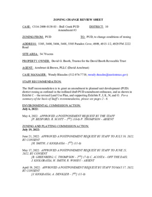
ZONING CHANGE REVIEW SHEET Amendment #3 DISTRICT: 10 CASE: C814-2009-0139.03 – Bull Creek PUD ZONING FROM: PUD ADDRESS: 5305, 5400, 5404, 5408, 5505 Paradox Cove; 4909, 4915-1/2, 4929 FM 2222 Road SITE AREA: 54.70 acres PROPERTY OWNER: David G. Booth, Trustee for the David Booth Revocable Trust AGENT: Armbrust & Brown, PLLC (David Armbrust) TO: PUD, to change conditions of zoning CASE MANAGER: Wendy Rhoades (512-974-7719, wendy.rhoades@austintexas.gov) STAFF RECOMMENDATION: The Staff recommendation is to grant an amendment to planned unit development (PUD) district zoning as outlined in the redlined draft PUD amendment ordinance, and as shown in Exhibit C – the revised Land Use Plan, and supporting Exhibits F, J, K, N, and O. For a summary of the basis of Staff’s recommendation, please see pages 2 - 6. ENVIRONMENTAL COMMISSION ACTION: July 6, 2022: May 4, 2022: APPROVED A POSTPONEMENT REQUEST BY THE STAFF [P. BEDFORD; R. SCOTT – 2ND] (10-0) P. THOMPSON – ABSENT ZONING AND PLATTING COMMISSION ACTION: July 19, 2022: June 21, 2022: APPROVED A POSTPONEMENT REQUEST BY STAFF TO JULY 19, 2022, BY CONSENT May 17, 2022: APPROVED A POSTPONEMENT REQUEST BY STAFF TO JUNE 21, 2022, BY CONSENT [B. GREENBERG; C. THOMPSON – 2ND] (7-0) C. ACOSTA – OFF THE DAIS; J. KIOLOBASSA, H. SMITH, R. WOODY – ABSENT [H. SMITH; J. KIOLBASSA – 2ND] (11-0) April 19, 2022: APPROVED A POSTPONEMENT REQUEST BY STAFF TO MAY 17, 2022, BY CONSENT [J. KIOLBASSA; A. DENKLER – 2ND] (11-0) C814-2009-0139.03 Page 2 March 1, 2022: APPROVED A POSTPONEMENT REQUEST BY STAFF TO APRIL 19, 2022 [H. SMITH; A. DENKLER – 2ND] (9-0) S. BOONE; R. WOODY – ABSENT January 18, 2022: APPROVED A POSTPONEMENT REQUEST BY STAFF TO MARCH 1, 2022 [H. SMITH; C. ACOSTA – 2ND] (10-0) R. WOODY – OFF THE DAIS [H. SMITH; D. KING – 2ND] (10-0) ONE VACANCY ON THE DAIS August 4, 2020: APPROVED AN INDEFINITE POSTPONEMENT REQUEST BY STAFF CITY COUNCIL ACTION: To be scheduled ORDINANCE NUMBER: ISSUES: The Applicant has discussed the proposed PUD amendment with Courtyard Homeowners Association, Cat Mountain Homeowners Association, North West Austin Civic Association, and 2222 Coalition of Neighborhood Associations (CONA). Correspondence from neighborhood groups is attached at the back of this report. The Applicant is in agreement with the Staff recommendation. EXHIBITS AND ATTACHMENTS TO THE STAFF REPORT: Exhibits A and A-1: Zoning Map and Aerial Exhibit B: Applicant’s Summary Letter; Redlined, draft PUD Amendment Ordinance; Code Comparison Chart, Code Modifications, and Tier 1 / Tier 2 Chart Revised Exhibits to the PUD: Exhibit C: Land Use Plan Exhibit F: Restoration Plan and Details Exhibit J: Cut and Fill Exhibit K: Construction on Slopes Exhibit N: Critical Environmental Features Exhibit O: Tree Protection Attachment A: Environmental Commission support material Correspondence Received C814-2009-0139.03 Page 3 CASE MANAGER COMMENTS: The proposed third amendment to the Bull Creek Planned Unit Development (PUD) consists of a single family residence with several accessory structures located at the confluence of Lake Austin and Bull Creek. Access is taken to FM 2222 via two driveways. The driveway on the north side of the property is adjacent to a “Tower” building that functions as security, property management, and guest quarters. The second driveway is approximately mid-point along the FM 2222 frontage and provides access to the residence. There are single family residences across Bull Creek in the Courtyard subdivision to the north (PUD), the Holdsworth Center, a non-profit retreat center is to the south (PUD), and single family residences in the Northwest Hills and Cat Mountain subdivisions are across FM 2222 to the east (SF-2; PUD). Please refer to Exhibits A (Zoning Map) and A-1 (Aerial View). The proposed third amendment to the PUD would allow for conversion of the property to a cultural services use (a museum with exhibition space), which is a type of civic use. Accessory uses to the cultural services use would include an art studio, classroom facilities, meeting space and food services, along with more immediate landscape design improvements. The “Tower” building on the north side of the property may be converted to a caretaker residence or other accessory use. The existing auto court, sports court and barn area on the north side of the property and near the “Tower” building would be converted to an onsite parking area. The existing walkways will be enhanced and additional walkways created to improve accessibility and connect art installations. The Applicant has worked with Austin Transportation Department (ATD) staff to limit traffic to the site to 400 vehicles per day and no more than 100 parking spaces. Below is a description of the proposed superiority items associated with the PUD amendment: Green Building: All new buildings associated with a cultural services use in the Bull Creek PUD will achieve a two-star or greater rating under the Austin Energy Green Building program using the applicable rating version in effect at the time a rating registration application is submitted for the building. (Please note that the current green building language in the original PUD was specific to the residential structure previously developed.) Open Space: Upon conversion of the Property to a cultural services use, open space within the PUD will exceed 50 percent. Environment / Drainage: Compliance with Current Code: After the Property is converted to a cultural services use it will adhere to the Watershed Protection Ordinance regulations and modifications outlined in this PUD amendment. Water Quality: Upon conversion of the Property to a cultural services use, new parking lots and new buildings greater than 8,000 square feet will provide water quality controls, as described in Section 1.6.7 of the Environmental Criteria Manual (ECM) (Green Storm Water Quality Infrastructure), to treat 100% percent of the water quality volume required by Code. C814-2009-0139.03 Page 4 This may include: rain gardens, vegetative filter strips, pervious pavers, porous pavement, non-required vegetation. Volumetric Flood Detention: The proposed Habitat Pond as shown on Exhibits C (Land Use Plan) and F (Restoration Plan and Details) will provide an additional 40,000 cubic feet of storage volume for the area, further eliminating direct discharge to Lake Austin. Trees: Upon conversion of the Property to a cultural services use, twenty (20) large caliper, transplanted Class A trees (predominately Live Oak and Cedar Elm), and approximately 1,670 caliper inches of canopy trees, and approximately 3,000 more understory trees and shrubs will be planted. Approximately 23 existing Pecan and Bur Oak Trees ranging from 7 - 12.75 caliper inches will also be relocated on the Property. Upon conversion of the Property to a cultural services use, 7.28 acres of woodland habitat enhancements including 1.20 acres of floodplain forest expansion, 1.10 acres of floodplain forest enhancements, 2.30 acres of lowland woodlands, and 2.68 acres of escarpment woodlands. All trees will be sourced from nurseries within 300 miles of the site and considered native to the Edwards Plateau or surrounding ecoregions and will be selected from the ECM Appendix N (City of Austin Preferred Plant List), the "Grow Green Native and Adapted Landscape Plants Guide", and/or the lists provided in the Restoration Plan. Porous Pavement: Upon conversion of the Property to a cultural services use, 50% of new walkways outside of the floodplain shall be constructed of porous pavement subject to compliance with Americans with Disabilities Act (ADA) Standards. Rainwater Harvesting for Landscape Irrigation: One hundred percent (100%) of irrigation water will be non-potable and sourced from Lake Austin. Innovative Measures to Provide Environmental Protection: The existing turf lawn around the main house will be revegetated to a minimum of 52,105 square feet or 1.20 acres of native planting areas. Additional sustainability facilities on the Property may including but not limited to solar panels, battery storage, wind appliances, thermal energy, and other components of a microgrid at locations to be determined. Such facilities shall be in compliance with applicable City of Austin requirements. Proposed code modifications are listed below: 1. Section 25-2-491(C) (Permitted, Conditional, and Prohibited Uses) is modified to allow cultural services as an additional permitted use of the Property. 2. Section 25-2-551(B)(3) (Lake Austin (LA) District Regulations) is modified to allow additional improvements within the shoreline setback area including: a habitat pond and artwork and its supporting foundations. C814-2009-0139.03 Page 5 3. Section 25-2-897 (Accessory Uses for a Principal Civic Use) is modified to allow an art studio, classroom, meeting facility, gift shop, coffee bar, snack shop, and cafeteria, as an accessory use to a principal civic use. 4. Section 25-2-1122 (Floor to Area Ratio of a Nonresidential Building) is modified to allow artwork and its supporting foundations and buildings associated with the civic use to be excluded from FAR calculations. 5. Section 25-2-1124 (Building Height) is modified to allow a maximum building height of 35 feet for a civic use and its related accessory uses. Artwork is excluded from the height limitation. 6. Development of the Property shall not be subject to Chapter 25-2, Subchapter E – Design Standards and Mixed Use, Section 2.2 (Relationship of Buildings to Streets and Walkways), 2.3 (Connectivity Between Sites), 2.4 (Building Entryways), 2.8 (Shade and Shelter), and Article 3 (Building Design Standards). 7. Section 25-5-81(B) (Site Plan Expiration) is modified to allow an expiration date of 10 years after a site plan is approved for a civic use. 8. Section 25-6-472(A) Appendix A (Tables of Off-Street Parking and Loading Requirements) is modified to require a minimum of 50 parking spaces, but no more than 100 parking spaces, for a civic use and its related accessory uses. 9. Section 25-8-261(C) (Critical Water Quality Zone Development) is modified to allow the habitat pond, riparian habitat, exclosures, existing and proposed guest house, caretaker residence, pervious & impervious walkways, low water crossings, site electrical, weir systems, and artwork and its supporting foundations within the critical water quality zone. This code section is also modified to allow cut and fill as required for the above improvements in accordance with Exhibit J (Cut and Fill). 10. Expanding upon the existing code modifications referenced in Part 5 Section D(11) of the approved PUD Ordinance No. 20111215-079, Section 25-8-281 (Critical Environmental Features) and Section 25-2-282 (Wetland Protection) is modified to allow the following improvements within the 150-foot wide buffer for the emergent wetland fringe and fringe wetland located within Bull Creek: habitat pond and riparian habitat, artwork and its supporting foundations; pervious and impervious walkways, and the restored existing boat house. 11. Section 25-8-341 (Cut Requirements) is modified to allow cuts to exceed four feet to allow for the construction of the proposed habitat pond as shown in Exhibit J. 12. Section 25-8-342 (Fill Requirements) is modified to allow fills to exceed four feet for the construction of the berm as shown in Exhibit J. C814-2009-0139.03 Page 6 BASIS OF STAFF RECOMMENDATION: 1. The proposed zoning should be consistent with the purpose statement of the district sought. Per the Land Development Code, PUD district zoning was established to implement goals of preserving the natural environment, encouraging high quality, sustainable development and innovative design, and ensuring adequate public facilities and services. The City Council intends PUD district zoning to produce development that achieves these goals to a greater degree than and thus is superior to development which could occur under conventional zoning and subdivision regulations. The PUD provides a canvas for the design of a large scale project, with the end goal to allow flexibility, and also inform and communicate the possibilities for development. Additional effort is required by all parties to ensure that development standards are clear and municipal and citizen needs are addressed. The PUD ordinance and related exhibits are key because once approved, they provide the regulations under which the project will be built, which provides certainty for developers and their agents. The Bull Creek PUD is comprised of approximately 54 acres of land fronting on Bull Creek and Lake Austin. PUD zoning is in keeping with the purpose statement of the district to preserve the natural environment, encourage high quality development, and innovative design. 2. The proposed PUD amendment still offers a development on the subject property that can create a distinct space that complements its unique location on Lake Austin and Bull Creek. It involves a change in land use from a residential project to a cultural services use, enhances the environmental features on the property and limits daily vehicular traffic to the site. EXISTING ZONING AND LAND USES: Zoning should allow for a reasonable use of the property. Site North South ZONING PUD PUD (Across Bull Creek) PUD East SF-2; PUD West Lake Austin LAND USES Single family residence and several accessory uses Single family residences in the Courtyard subdivision Holdsworth Center, a non-profit retreat center dedicated to training and leadership development for public educational facilities Single family residences in the Northwest Hills and Cat Mountain subdivisions Not applicable NEIGHBORHOOD PLANNING AREA: Not applicable TIA: Waiver approved by Austin Transportation Department staff in February 2022 C814-2009-0139.03 Page 7 WATERSHEDS: Bull Creek Watershed; Lake Austin Watershed – Water Supply Suburban CAPITOL VIEW CORRIDOR: No HILL COUNTRY ROADWAY: Yes, Low Intensity 157 – Courtyard Homeowners Association SCHOOLS: Highland Park Elementary School Lamar Middle School McCallum High School COMMUNITY REGISTRY LIST: 53 – Northwest Austin Civic Association 245 – Cat Mountain Homeowners Association 416 – Long Canyon Phase II & III Homeowners Association 425 – 2222 Coalition of Neighborhood Associations, Inc. 475 – Bull Creek Foundation 511 – Austin Neighborhoods Council 742 – Austin Independent School District 943 – Save Our Springs Alliance 1228 – Sierra Club, Austin Regional Group 1363 – SEL Texas 1424 – Preservation Austin 1530 – Friends of Austin Neighborhoods 1596 – TNR BCP – Travis County Natural Resources 1616 – Neighborhood Empowerment Foundation 1774 – Austin Lost and Found Pets AREA CASE HISTORIES: 1507 – NW Austin Neighbors 605 – City of Rollingwood 1603 – Westminster Glen HOA COMMISSION CITY COUNCIL NUMBER C814-2017-0024 – Holdsworth Center PUD – 4907 FM 2222 Rd REQUEST LA; SF-2 to PUD for a 44.17 acre non-profit retreat center dedicated to training and leadership development Texas public school districts To Grant PUD including the Transportation Demand Management (TDM) program, improvements to RM 2222 as agreed to with TXDoT, and prohibiting hotel-motel use Apvd PUD as Commission recommended w/revised and new conds relating to development of the property, Heritage trees, establishment and use of the public access easement along RM 2222, defining and monitoring vehicular trips, requiring a new TDM program upon transfer of the Property, compliance with the TDM program, clarifying lighting language, adding property lines to fence requirements, requiring an C814-2009-0139.03 Page 8 ornamental fence on RM 2222 and installation criteria, and restricting sound amplification (12-14-2018). Apvd (11-13-1975). To Grant C814-74-005 – Cat Mountain Villas – Lookout Mountain Drive at FM 2222 Rd SF-3 to PUD for 372 single family detached and attached units w/common space and amenities RELATED CASES: City Council approved the Bull Creek PUD which consists of one single family residence with several accessory structures in July 2010 (C814-2009-0139). Note that PUD zoning does not include the additional 17.23 acres that was conveyed to the Owner in 2015 and is inundated by the Lake Austin and Bull Creek. The first amendment to the PUD related to tree protection was approved administratively in April 2011. The second amendment added a 0.83 acre tract known as the Design Center to the PUD and was approved by Council on December 15, 20112 (C814-2009-0139; C814-2009-0139.01; C814-2009-0139.02). ADDITIONAL STAFF COMMENTS: Inclusive Planning This property is located on the northeast side of Bull Creek and the Colorado River, and to the west of FM 2222. The subject area is not located within the boundaries of a small area plan, an Activity Center or Activity Corridor. The project area 54.7 acres in size and contains one large single family house and several accessory buildings. This is a third amendment to an existing PUD and calls for the approval of art exhibition space, several accessory structures (several that are pre-existing) and additional landscaping to augment the existing single-family compound. Imagine Austin There are no Capitol Metro transit stops, bike lanes or public sidewalks located within a mile of this site. Based upon the scale of the proposed and existing improvements in relation to the 54.7 acres site, and the property not being located along an Activity Corridor or Center, this PUD amendment is beyond the scope of policies of the Imagine Austin Comprehensive Plan. C814-2009-0139.03 Page 9 Drainage The developer is required to submit a pre- and post-development drainage analysis at the subdivision and site plan stage of the development process. The City’s Land Development Code and Drainage Criteria Manual require that the Applicant demonstrate through engineering analysis that the proposed development will have no identifiable adverse impact on surrounding properties. Environmental Please refer to Attachment A (Environmental Commission support material). Floodplain The location of the PUD zoning case is on Lake Austin near the confluence of Bull Creek. The Applicant is not requesting any code modifications regarding floodplain ordinances. The Applicant has stated in the superiority table that there will be no modification to the existing 100-year floodplain. Impervious Cover The proposed maximum percentage of impervious cover is 20% on a net site area basis. Austin Water Utility No comments on PUD amendment. SF-6 GO 85-044 OFFICE COMPLEX LO B Y S W S H A X E F T L O PITA B Y N W S H A X E F T L O PITA A N C A N C 92-89 LR-CO W E ST C LO O U R T Y A R D D R J A M B O R E E C T ( ( ( ( ( ( ( ( ( ( ( ( ( ( ( ( B A C K C T ( ( C O U R T Y A R D C V ( ( ( C O U R T Y A R D D R ( ( ( ( ( ( ( V C A W A K N A R A K ( UNDEV 93 - 01 2 0 SF-6 ( ( 97-0089 ( ( PUD V ( N C O T G RIN R A H ( ( ( ( ( S C O U T BLUFF D CIR N A L T IS U O C N S PUD 85-026RC GR-MU SP-98-0027C 85-026 TENNIS COURTS SF-6-CO 80-156 93-0120 ( ( ( ( ( ( ( ( ( ( ( ( PUD ( ( ( ( ( ( ( ( ( I ( R C N O T S U O H M A S ( ( ( ( ( ( ( ( ( ( 0 2 93-01 V E D N U ( ( ( ( ( I E G D R E D A R A P ( ( ( ( ( ( ( ( ( ( ( LITTLE B ULL C V ( ( ( ( ( ( ( ( ( ( ( ( PUD ( ( ( E T IN N U O ( R C ( ( ( ( ( ( ( ( ( ( ( ( ( ( ( ( ( I S L A N D C I R ( ( ( S S C O U T ( ( ( ( ( ( ( C IL C V ( PUD ( ( ( ( ( ( ( CONE CIR ( ( ( ( ( ( ( ( ( ( ( M W T O ( ( ( ( R N D ( T E O O ( ( ( ( ( ( ( ( ( ( ( ( 81-020 ( ( C814-75-0201 ( ( ( ( ( PUD ( ( LA LA PUD EAGLE CLIFF W O L F C T SF-2 C O L O R A D L A K E A U S TIN O RIV E R 97-0149 C14-97-0149 CR-CO ! ! ! ! ! ! ! ! ! ! ! ! ! ! ! ! ! ! ! ! ! ! ! ! ! ! ! ! ! ! ! ! ! ! ! ! ! ! ! ! ! ! ! ! ! ! ! ! ! ! ! ! ! ! ! ! ! ! ! ! ! ! ! ! ! ! C14-83-003.25(DE) 83-003.25(DE) PARADOX CV PUD SF-2 ! ! ! ! ! ! ! ! ! S D 6 4 3 0 - 8 8 P S ! ! ! ! ! ! ! ! ! ! ! ! ! ! ! ! ! ! ! ! ! ! ! ! D R 2 2 2 2 M F C814-2009-0139.01 C814-2009-0139.02 C814-2009-0139 ! ! ! !! ! ! ! ! ! ! ! ! ! ! ! !! SF-2 ! ! ! ! ! ! ! ! ! ! ! ! ! ! ! ! ! ! ! ! ! ! ! ! ! ! ! ! ! ! ! ! ! ! ! ! ! ! ! ! ! ! LA !! C814-2017-0024.01 C814-2017-0024 PUD SF-2 2 3.0 0 83-00 SF-2 ( 5 5 3.2 83-00 ( 83-003.73 83-003.255 ( 8 3 ( - 0 0 3 . 2 4 4 83-003.71,72 ( SF-2 N A L N U G 5 A 5 L 3.2 83-00 SF-2 8 3 - 0 0 3 . 1 8 6 LA ( SF-3 5 6 3.1 83-00 ( LA C H A N N E L R D 83- 003.264 ( 83-00 3.7 0 0 4 ( 3.2 83-00 1 3.8 83-00 SF-2 5 5 3.2 83-00 83-003.74 ( LA ( ( SF-2 ( 83-003.163 83-003.17 MF-2 ( LA LA SF-2 ( .75 ( 97-0149 ± SUBJECT TRACT ! ! ! ! ! ! PENDING CASE ZONING BOUNDARY PLANNED UNIT DEVELOPMENT EXHIBIT A ZONING CASE#: C814-2009-0139.03 This product is for informational purposes and may not have been prepared for or be suitable for legal, engineering, or surveying purposes. It does not represent an on-the-ground survey and represents only the approximate relative location of property boundaries. 1 " = 600 ' This product has been produced by CTM for the sole purpose of geographic reference. No warranty is made by the City of Austin regarding specific accuracy or completeness. LA SF-3 PUD SF-3 BELVEDERE ST PUD T W I N V A L L E Y D R N O R T H W E S T P L PUD C814-74-005 PUD M O U N T B O N N E L L R D O L W N H R F E PUD L O O K O U T M O U N T SF-2 AIN D R PUD W E S T S L O P E C V PUD SF-2 ( ( ( ( ( ( ( ( ( LA K E VIE W CIR ( ( SF-2 ( ( W E S T S L ( O P E D R ( ( ( W E S T S L ( O P E CIR ( ( ( ( ( ( ( ( ( ( ( ( ( ( ( P A L I S ( A D E D R ( ( ( ( ( LEEWARD CT ( ( ( ( ( ( Exhibit A - 1 ORDINANCE NO. 20111215-079 AN ORDINANCE AMENDING ORDINANCE NO. 20100729-120 TO INCREASE BY 0.83 ACRES THE BOUNDARIES OF THE PROJECT KNOWN AS THE BULL CREEK PLANNED UNIT DEVELOPMENT PROJECT AND REZONING THE 0.83 ACRES FROM INTERIM-LAKE AUSTIN RESIDENCE (I-LA) DISTRICT TO PLANNED UNIT DEVELOPMENT (PUD) DISTRICT; MODIFYING THE LAND USE PLAN, REZONING AND CHANGING THE ZONING MAP FROM PLANNED UNIT DEVELOPMENT (PUD) DISTRICT TO PLANNED UNIT DEVELOPMENT (PUD) DISTRICT FOR THE PROPERTY LOCATED AT 4909, 4923,4925, AND 4929 FM 2222 ROAD. BE IT ORDAINED BY THE CITY COUNCIL OF THE CITY OF AUSTIN: PART 1. Bull Creek Planned Unit Development ("Bull Creek PUD") is comprised of approximately 55 acres of land located generally in the 4900 block of FM 2222 Road in Travis County and more particularly described by metes and bounds in the land use plan incorporated into Ordinance No. 20100729-120 (the "Original Ordinance") as approved July 29, 2010. PART 2. The zoning map established by Section 25-2-191 of the City Code is amended to change the base district from planned unit development (PUD) district to planned unit development (PUD) district on the property described in the Original Ordinance and as Tract One below, and to change the base district from interim-Lake Austin residence (I- LA) district to planned unit development (PUD) district on the property being added as Tract Two to the Bull Creek PUD, as follows: Tract One: Approximately 53.8741 acres in Travis County, consisting of two tracts of land and being more particularly described in Exhibit "A" incorporated into this ordinance; and Tract Two (the "Tower Lot"): A 0.83 acre tract being all of Lot 2, Bull Creek Road Subdivision, a subdivision in Travis County, Texas, according to the map or plat of record in Volume 28, Page 17, of the Plat Records of Travis County, Texas (collectively, the "Property"), locally known as 4909, 4923, 2925, and 2929 FM 2222 Road, in the City of Austin, Travis County, Texas, and further described in Zoning Case No. C814-2009-0139.02, on file at Page 1 of 9 the Planning and Development Review Department, and generally identified the map attached as Exhibit "B". PART 3. This ordinance and the attached Exhibits "A" through "O" are the amended land use plan ("Bull Creek Land Use Plan") for the Bull Creek PUD and amends the Original Ordinance. Development of and uses within the Bull Creek PUD shall conform to the limitations and conditions set forth in this ordinance and in the attached Bull Creek Land Use Plan. If this ordinance and the attached exhibits conflict, this ordinance controls. PART 4. The attached exhibits are incorporated into this ordinance in their entirety as though set forth fully in the text of this ordinance. The exhibits are as follows: Exhibit A: Description of Property: Tracts One and Two Exhibit B: Amended Zoning Map Exhibit C: Amended Land Use Plan Exhibit D: Amended Notes Exhibit E: Ecological Preservation/Rehabilitation Plan Exhibit F: Constructed Habitat for Migratory Waterfowl Plan Exhibit G: Amended Green Building & Environmental Benefits (G-l, G -2, G- 3) Exhibit H: Artwork Exhibit I: Exhibit J: Environmental Modification Plan - Cut & Fill Exhibit K: Environmental Modification Plan - Construction on Slopes Exhibit L: Amended Slope Analysis (L -1, L - 2) Exhibit M: Driveway Details Exhibit N: Amended Critical Environmental Features (N-l) Exhibit O: Amended Tree Protection (O - 1, O- 2) Swim Pier PART 5. In accordance with Chapter 25-2, Subchapter V, Article 2, Division 5 (Planned Unit Developments) of the Code, the Bull Creek PUD development shall comply with the requirements for a PUD, except as otherwise modified by this ordinance. A. Use Regulations. 1. 2. Except as otherwise provided in this ordinance the Property is subject to Lake Austin residence (LA) district permitted and conditional uses and site development regulations. Crop production use and urban farm use are additional permitted uses of the Property. Page 2 of 9 3. 4. 5. 2. Section 25-2-863 (C) (Urban Farms) of the Code is modified to allow an urban farm on a site greater than five acres. Section 25-2-893 (C) (Accessory Uses for a Principal Residential Use) of the Code is modified to allow two guest houses. The structure on the Tower Lot may be used as a guest house, in addition to the two guest houses on the Tract One property. Section 25-2-900 (Home Occupations) of the Code is modified so that only the following home occupation regulations apply: a) a home occupation may occur within the primary residence, the Tower Lot, or accessory structures, and b) a home occupation may include the occupant of the primary residence and staff assisting with property and household management, domestic service household maintenance (interior and exterior), landscaping, security, bookkeeping, and personnel working for the owner or owner's nonprofit foundation. B. Zoning and Site Development Regulations. 1. With the addition of the Tower Lot, the maximum impervious cover is 15 percent. (Impervious Cover [44]—percent. Section 25-8-64 Assumptions) of the Code is modified to allow impervious cover to be calculated over the entire Property and not on a lot by lot basis. Section 25-2-551(8) (2) (Lake Austin (LA) District Regulations) of the Code is modified to allow additional improvements within the shoreline setback area as shown on Exhibits C and J. These include a constructed habitat for migratory improvements may waterfowl, decks, terraces, skyspace structure, site electrical, weir system, berms, swimming area, and related improvements. Maintenance and remodel of existing swimming area, boat doeks, walkways, and associated facilities is allowed. impervious walks, boardwalk, trails, 3. Section 25-2-551(B) (5) (Lake Austin (LA) District Regulations) of the Code is modified to allow development of a guest house and recreation building on limited gradients that exceed 35 percent in accordance with Exhibit K. Page 3 of 9 4. 5. Seclion 25-2-492 (Site Development Regulations) of the Code is modified to allow interior side yard setbacks to be zero feet. Section 25-2 Subchapter F: Residential Design and Compatibility Standards, 2.5 (Side Yard Setbacks) and 2.6 (Setback Planes) of the Code are modified to allow interior side yard setbacks to be zero feet and interior lot line setback planes not to apply. C. Hill Country Roadway. 1. The PUD shall comply with the Hill Country Roadway Ordinance except as shown in this Subsection C. a) Section 25-2-1122 (Floor to Area Ratio of a Nonresidential Building) of the Code is modified to allow compliance with Exhibit K for construction on slopes. b) Section 25-2-1123 the Code is modified to allow construction of the guest house to comply only with Exhibit K. (Construction on Slopes) of c) Section 25-2-1126 (Building Materials) of the Code is modified to allow reflective and non-native building materials for structures built JOO feet behind a 10-foot high masonry wall that is constructed 100 feet from the right-of-way of FM 2222 Road. A vegetative buffer with native plants and trees shall be provided as additional screening. d) A 100-foot wide vegetative buffer shall be provided and maintained along the property line adjacent to the FM 2222 right- of-way. At approximately the 100-foot setback line a 10-foot high wall or fence shall be constructed for visibility and sound attenuation. Additional native trees will be planted to supplement the existing native vegetation. Entryway features are allowed within the setback in the vicinity of the driveways. e) At least 40 percent of the site within the Hill Country Roadway 1000 foot setback area shall be left in a natural state, except for the vegetative management activities in accordance with a) existing wildlife management plan approved by the Travis County Page 4 of 9 D. Environmental Regulations. the Ecological Appraisal District Conservation and Preservation Plan outlined in Exhibit E of (his ordinance. the property and, b) for The City acknowledges and agrees that the existing building on the Tower Lot is a legal noncomplying structure, and as such, shall be subject to applicable City Code provisions. Development of the Property shall comply with the criteria, plans, or requirements as written or illustrated on Exhibits D, E, F, G, J, K, L, N,and O. Section 25-8-261(C) (Critical Water Quality Zone Development) of the Code is modified to allow the following improvements within the critical water quality zone as shown on Exhibit C and described in Exhibit J: a) migratory bird habitat, birdbath facilities, decks, trails, levees, sidewalks, boardwalk, terraces, skyspace structure, security equipment, wiring, swimming area, and related facilities; remnant foundation, b) maintenance and remodel of existing swimming area, boat docks, walkways, and terraces; and c) cut and fill as required for the above improvements in accordance with Exhibit J. Section 25-8-281 (B) (Critical Environmental Features) of the Code is modified to allow critical environmental features ("CEF") to be located on a residential lot. Section 25-8-281 (C) (Critical Environmental Features) of the Code is modified to provide buffer requirements for the CEFs on the Property in accordance with Exhibit N. 2. 1. 2. 3. 4. Page 5 of 9 5. 6. 7. 8. 9. Sections 25-8-281 (Critical Environmental Features) and Section 25- 8-282 (Wetland Protection) of the Code do not apply to any proposed manmade environmental features. Section 25-8-302 (Construction of a Building or Parking Area) of the •Code is modified to allow small portions of building and parking areas to be constructed on slopes greater than 25 percent, as shown on Exhibit K. Terracing shall be optional for portions of the slopes that are not constructed on, but spanned by a building. Section 25-8-341 (Cut Requirements) of the Code is modified to allow cuts to exceed four feet in accordance with Exhibit J. Section 25-8-342 (Fill Requirements) of the Code is modified to allow fills to exceed four feet in accordance with Exhibit J. The requirements of Sections 3 through 3.3.5 (Tree Survey) of the Environmental Criteria Manual ("ECM") are modified to allow only trees of eight inch and greater diameter to be surveyed and for single family tree regulations to apply. 10. CEF Buffers and Construction. The following conditions apply to the 50-foot wide buffer for Rimrocks 1 and 2 as shown on Exhibit N: a) a 40-foot limit of construction shall be maintained from Rimrock 1 and 2; b) the 10-foot wide area with the CEF buffer that is disturbed during construction must be revegetated with plants and seeds from the City of Austin Standard Specification Item No. 609S, and c) erosion and sedimentation controls must be placed at the limits of construction. 11. A 150-foot wide buffer shall be provided for the emergent wetland fringe located within Bull Creek. The following may be located within the buffer area: Page 6 of 9 Trails, existing retaining wall, proposed trees, stone stairs, regraded slope, migratory habitat for waterfowl, raised wood boardwalk, native plant garden, security equipment, wiring, and related facilities. 12. A setback is not required for or associated with a cypress fringe located on portions of the Property. E. Shoreline Swim Area/Docks and Wetlands Area. 1. 2. Swim area reconstruction shall not exceed 50 feet from the shoreline in accordance with Exhibit I. Shoreline modifications for the swim area will exceed Code and ECM requirements in order to preserve the natural and traditional character of the shoreline as set forth under Section 25-7-61 (A)(5) (Criteria for Approval of Plats, Construction Plans, and Site Plans), maintain the integrity of protected riparian areas and minimize damage to physical and biological characteristics set forth in Section 1.7.7(A) ECM. Parts of the proposed plan will: a) maintain the water quality benefits and biological integrity of a functioning, natural vegetated shoreline by providing landscape details which replace existing shoreline vegetation with more desirable native species that provide bank stabilization and natural character; b) provide the slope of a natural shoreline with minimal stone toe for bank of City of Austin Environmental Resource armor pursuant stabilization Management Division wetlands biologist; recommendations the current to c) provide native wetland plantings as mitigation for any impacts to protected wetland areas with the approval of City of Austin Environmental Resource Management Division wetlands biologist; and d) provide the seal of a Texas professional engineer to certify that the hydraulic and structural design of dock and shoreline treatment are adequate that the improvement complies with the ordinances of the City, Drainage Criteria Manual, and the laws of the State as set Page 7 of 9 3. 1. 2. forth in Section 25-7-62 (Certificate of Professional Engineer Required for Certain Alterations and Improvements) of the Code. Additionally, boat slips may not exceed 12, and a boat slip may not be used for commercial purposes. The Tower Lot may maintain the two additional boat slips associated with it, in addition to the 12 boat slips existing on the Tract One property. However, they may not be used for commercial purposes. F. Transportation Regulations The southern internal driveway shall be built in accordance with Exhibit M. The requirements of the Transportation Criteria Manual Section 5.3P and the City of Austin Standard Detail 433S-1 are modified to allow a driveway apron to slope away from the street and to exceed a two percent grade for the driveway apron. (See Exhibit M) G. Drainage Regulations. Section 25-7'-152 (Dedication of Easements and Rights-of Way) of the Code is modified so that a drainage easement dedicated to the public is not required for flows onto the property; provided however, the property shall accept flows from adjacent tracts in accordance with natural drainage patterns. An easement for the FEMA floodplain shall satisfy dedication requirements along Bull Creek. H. Artwork. At least 2 art installations shall be provided on the Property in accordance with Exhibit H. PART 6. Except as otherwise specifically provided for in this ordinance, the terms and conditions of Ordinance No. 20100729-120, as amended, remain in effect. Page 8 of 9 PART 7. This ordinance takes effect on December 26, 2011. PASSED AND APPROVED December 15 ,2011 § L APPROVED: ^" y> i^ mnattr City Attorney effing well Mayor Shirley A. Gentry City Clerk Page 9 of 9 TRACT I FIELD NOTES FOR 44.572 ACRES OF LAND ALL OF THAT CERTAIN TRACT OR PARCEL OF LAND OUT OF THE THOMAS J. CHAMBERS 8 LEAGUE GRANT IN TRAVIS COUNTY. TEXAS, BEING ALL OF THAT CERTAIN 44 572 ACRE TRACT OF LAND CONVEYED TO KEY ENTERPRISES, INC., TED L. STEWART AND RON AMINI BY INSTRUMENT RECORDED IN DOCUMENT NO. 2004145327 OF THE OFFICIAL PUBLIC RECORDS OF TRAVIS COUNTY, TEXAS, SAID TRACT BEING MORE PARTICULARLY DESCRIBED BY MET 3 AND BOUNDS AS FOLLOWS: BEGINNING at a 1A inch iron pin found at the Northeast corner of said 44.572 acre tract, being at the Southeast comer of Lot I, Bull Creek Road Subdivision, a subdivision recorded in Plat Book 28, Page 17 of the Plat Records of Travis County, Texas, being in the West r.o.w. line of F.M. Hwy No. 2222, for the PLACE OF BEGINNING hereof; THENCE along the East line of said 44.572 acre tract, being m .g the West r.o.w. line of F.M. Hwy No. 2222 for the following courses: AJoog a curve to the left whose radius is 408.15 feel, whose arc is 57.^5 feet and whose chord bears S 07°20'50n W for a distance of 57.60 feet to a J4 inch iron pin found S 01*29'54" E for a distance of 119.52 feet to a '/a inch iron pin found S 03°17W W for a distance of 751.90 feel to a '/S inch capped iron pin set for the Southeast comer of said 44.572 acre tract; THENCE along a Southerly line of said 44.572 acre tract for die following courses: N 88°1 S'OO" W for a distance of 287.50 feet to a K inch capped iron pin set N 60*30'00" W for a distance of 387,50 feet to a 'A inch capped iron pin set N 88*30 W W for a distance of 200.00 feet to a V» inch capped iron pin s«t S 44°30'00" W for a distance 0/222.50 feet to aK inch capped iron pin set S 01 °30'00** \. for a distance of 180.00 feet to i. Yi inch capped iron pin set S 36"20'OG" E for a distance of 353,21 feet to a'/i inch capped iron pin set S 39°20'00" W for a distance of 540.43 feet to a point at the water's edge of the North bank of Lake Austin, for a Southerly comer of said 44.572 acre tract; THENCE along the waiers edge of the North bank of Lake Austin for the following courses: N 50*41* 13" W for a distance of 293.66 feet to an angle point N 54°13'30" W for a distance of 481.15 feet to an angle point FIELD NOTES FOR 44.572 ACRES OF LAND - Page Two N 4905<T24" W for a distance of 135.83 feet to a point at the water's edge of the East bank of Bull Creek, for the Southwest comer of said 44.572 acre trad; THENCE along the water's edge of the East bank of B. . Creek for the following courses: N 03*09'5B" E for a distance of 9.95 feet to an angle point N 39°03'55" E for a distance of 500.02 feet to an angle point N 33*35*47* W for a distance of 57.70 feet to an angle point N 25q18'4r W for a distance of 152.65 feet to an angle point N I7°04'3rw for a distance of 23.61 feet to an angle point N 13*S9*42fW for a distance of 159.33 feet to an angle point • -N-OCM8* 15" W for a distance of 177.67 feet to an angle point MI I°27'02"E fora distance of 183.31 feet to an angle point N 24e04'28" E for a distance of 73.27 feet to a 60-d nail set in a tree stump for the Northwest comer of said 44.572 acre tract; THENCE along the North line of said 44,572 acre tract for the following courses: N 89*39*31" E for a distance of 232.09 feet to a Vi inch iron pin found N SQ'IO110" E for a distance of 76.00 feet to an iron bolt found N.89°15'25" E for a distance of 569.23 feettoa V4 inch iron pin found N 89°00'02" E for a distance of 555.61 feet to a £ inch iron pin found N 89°I4'44" E for a distance of 2J6.58 feel to the PLACE OF BEGINNING and containing 44,572 acres of land, more or less. SURVEYED BY: Roy D. Smith Surveyors, P.C. ROYDySMlTH REGISTERED PROFESSiqSP^.'gaS^WOO. 4094 August 18.2005 44.572 ac. - T.J. Chambers Part A: Lot 1, BULL CREEK ROAD SUBDIVISON, a subdivision in Tiavis County, Texas, according to the map or plat thereof, recorded in Volume 28, Page(s) 17 of the Plat Records of Travis County. Texas TRACT2 and Part B: Being 8.495 acres of land, more or less, and lying in and situated out of the Thomas J. Chambers Survey in Travis County, Texas and being more particularly described on Exhibit B-l attached hereto and made a part hereof. EXHIBIT B-1 LEGAL DESCRIPTION: B'EING A 8.495 ACRE TRACT OF LAND LYING IN AND BEING SITUATED OUT THE THOMAS J. CHAMBERS SURVEY, ABSTRACT NO. 198 IN TRAVIS COUNTY. TEXAS AND BEING All OF THOSE CERTAIN FOUR PARCELS OF LAND CONVEYED TO 4-D PARTNERS L.P. AS T R A C TS 2-5 BY DEED RECORDED IN DOCUMENT NO. 19999133413 OF THE OFFICIAL PUBLIC RECORDS OF TRAVIS COUNTY, TEXAS; SAID 8.495 ACRE TRACT BEING MORE PARTICULARLY DESCRIBED AS FOLLOWS AND AS SURVEYED UNDER THE SUPERVISION OF JAMES E. GARON & ASSOCIATES IN OCTOBER. 2007: BEGINNING at an Iron pipe found in the northerly that certain 44.572-acre tract of land conveyed to Danforth Partners I. LTD by deed recorded In Document No. 2001057457 of said deed records for the southeast corner of said 4-D Partners Tract 5 (3.845 acres) and the southwesterly corner of Lot 1, Bu!l Creek Road Subdivision, a sub£ vision of record in plat book 28, page 17 of the Plat Records of Travis County, Texas; line of THENCE along the north line of said Danforth tract and the south line hereof and said 4-D Partners tract the following six (6) calls: 1. N 89*45*40" W a distance of 555.41 feet to a V£" iron rod found for angle point and common corner of tracts 2 and 5; 2. N 89'25130" W a distance of 152.99 feet to a VS" iron pipe found for angle point and common corner of tracts 2 and 3; 3. N 89*22"! 3" W a distance of 122,77 feet to a YS Iron rod found for angle point; 4. N a9"36'49* W a distance of 293.52 feet to a 5/8 * iron boll found for angle point and common corner of tracts 3 and 4; 5. N 89*35'58" W a distance of 75,97 feet to a J5" Iron rod found for angle point; 8. N 89°26'01* W a distance of 234.85 feet to a calculated point in Lake Austin for the southwest corner hereof and said 4-D Partners L.P. Tract 4; THENCE ale 9 Lake A u s t in and Bu'~ Creek the following e' ven (11) calls: 1. N 33"56159" E a distance of 39,50 feet to a 1/j" i ron rod found 2. N 38'51'40" E a distance of 162.51 feet to a Y*~ iron rod found for angle point; for angle point; - r s t i fi .".-Hia I n c. H7 A D I 1 O 5 5G TR 2 0 0 1 1 3 S ? 9 6 . 0 07 • Page 2 October 9,2007 3. N 58"15'39" E a distance of 92,69 feet to a %* iron rod found 4. N 67"58'38- E a distance of 140.40 feet to 3 V4" Iron rod found 5. N 81*34*15" E a distance of 137.21 feet to a X" iron rod found 6. S 89*24'48" E a distance of 209.81 feet to a Vi" iron rod found 7. N 89'52'53* E a distance of 85.01 feet to a '/>" iron rod set for B. 5 78*00*25" E a distance of 71-35 feet to a '/a" i ron rod found 9. N 89*12*18" E a distance of 215.78 feet to a c a l c u l a t ed point for angle point; for angle point; for angle point; for angle point; angle point; for angle point; In water; point in water; 10. 11. S 8r08'51" E a distance of 94.90 feet to a calculated N 87*20'09' E a distance of 373.03 feet to a Vi" iron rod set for the northeast corner hereof and said 4-D Partners tract 5 and the northwest corner of the aforesaid tot 1. Bull Creek Road Subdivision; THENCE S 15*57'31P W a distance of 291.00 feet along the west line of said Lot 1 to the POINT OF BEGINNING, containing 8,495 land, more or less and as shown on sketch of survey acres of prepared herewith. Surveyed by: James E. Garon Registered Professional Land Surveyor Server: Co\Travts\Surveys\Thomas J Chambers\B58607.doc Dataa Ino. HT ADI10560 TR 2 007 IS 9 9 9 6 . 008 XN AO\C> K°KS),^-L!JI>> C< )in>;v9>/°^ToK SUBJECT TRACT PENDING CASE ZONING BOUNDARY PLANNED UNIT DEVELOPMENT ZONING CASE#: C814-209-0139.02 LOCATION: 4909 FM 2222 RD SUBJECT AREA: 54.7041 ACRES GRID: G29 MANAGER: CLARK PATTERSON This map has been produced by the Communications Technology Management Dept. on behalf of the Planning Development Review Dept. for the sole purpose of geographic reference. No warranty is made by the Citv of Austin reaardina soecific accuracy or comoleteness. Cft-CO N ^77\ SUBJECT TRACT *\ PENDING CASE tT J 2°NING BOUNDARY A f PLANNED UNIT DEVELOPMENT ZONING CASE#: C814-2G09-0139 LOCATION: 4909, 4923 & 4925 FM 2222 SUBJECT AREA: 53.8741 ACRES GRID; G29 MANAGER. C. PATTERSON This map has been produced by the Communications Technology Management Depl on behalf of the Pfannfng Development Review DapL for the sole purpose or geographic reference. No warranty is made by the Citv of Austin reoardno soeciflc accurate or comolelenosa / / 'f^m/'/$ ^ J'/x^-W BULL CREEK PUD EXHIBIT D-NOTES During construction, the existing structure on the property may be used as a dwelling and for activities to assist the site with construction. The project will comply with the single family residential tree removal and clearing requirements of the City Code in effect on the date the PUD application was submitted. The PUD is for one single family residence with accessory uses. A tree clearing permit shall be required only for 19 inch diameter and larger protected trees. Lighting for the skyspace structure shall only allow a low level of ulterior lighting outward. Only a very small amount of light will escape skyward through the opening, but no lights will be directed at the opening itself. Light fixtures will have a diffusing cover over them. Luminaires shall not shine directly onto neighboring properties, roadways or distribute excessive light skyward. The proposed main house, barn, recreation center, and guest house structures shall provide fire sprinkler protection. As part of the building permit process, the Owner shall work with Austin Fire Department to develop final designs in accordance with NFPA standards. 5. In lieu of a dedicated drainage easement, the Owner shall: a. b. c. d. Continue to accept and convey all offsite runoff through the Property. Not increase the velocity of the runoff beyond the Property, including appropriate detention, if necessary. Operate, maintain, replace, upgrade, and repair any natural drainage ways and related facilities. Allow the City to inspect the drainage area with prior written notice and an appointment with the Owner or Owner's agent. Administrative site plans shall be submitted for review and approval for new improvements to the swim area, boat docks, and proposed habitat for migratory waterfowl. If environmental variances are requested for the recreation building, then an administrative site plan shall be submitted for it. Due to the overall residential use, no other site plans shall be required. to Site plan regulations, such as landscaping and other requirements applicable commercial uses shall not be applied to the administrative site plan(s). Tree surveys shall be submitted when required by single family regulations, in accordance with such Parking at the Tower Lot shall be for home occupation or residential use only. Trees on the Tower Lot shall be subject to the Heritage Tree Ordinance as of the date of this PUD amendment #2 submitted. {W0510144.1} 1. 2. 3. 4. 6. 7. 8. BULL CREEK PUD EXHIBIT E - ECOLOGICAL PRESERVATION/REHABILITATION PLAN The Bull Creek PUD property has remained more or less intact in the midst of a highly developed urban area. However, over the years it has been overgrazed by domestic livestock and generally neglected which has resulted in a proliferation of normative and invasive species. Its diverse attractions include lake and creekside frontage, gently rolling hills, arroyos, mature oaks and junipers, and a wide expanse of meadows. Thus, the property has the potential to become a species-rich biosphere with many benefits to wildlife, water quality and the neighboring landscape. GOAL 1. 2. 3. 4. 1. 2. To initiate an on-going program of landscape interventions designed to hasten positive changes that will help the property self-heal, so that more diverse plant communities with greater ecological stability will thrive. The intention is to make the property more hospitable and attractive to wildlife and humans alike. PREVIOUSLY INITIATED WORK Meadow Rehabilitation - Native grasses have been planted to restore the grassland area to its natural state. This process was started in 2008 and efforts will continue for four seasons on approximately 12 acres of the site. Removal of Invasive Tree Species - Non-native species of trees have been removed. However, this is an ongoing project and most efforts have been focused on woody plant species. This program of removing aggressive invasive species will be part of the continuing management plan for the property. Native Hardwood Tree Plantings - Over the last year, the following trees and shrubs have been planted, with appropriate irrigation, to create diversity to the woodlands areas on the site: 125 - 15 gallon trees, 6-20 gallon trees, 27 - 30 gallon trees, 30 - 65 gallon maple trees (4 inch calipher balled and burlapped), for a total of 188 trees and shrubs. Numerous additional trees are proposed to be planted over the next several years. Slope Stabilization - Slope stabilization has been installed where dense stands of invasive species have been removed and in the woodlands areas where some of the cedar or ashe In accordance with the proposed juniper have been thinned to help control erosion. removal of invasive species, additional slope stabilization is proposed. GENERAL STRATEGIES FOR IMPROVING CONDITIONS Remove invasive species each growing season and replacing with native trees, shrubs, grasses, and forbs. Through plowing, direct seeding of native grasses and forbs, and cultivation of cover crops, suppress noxious weeds, reduce soil compaction, and gradually increase the successful establishment of native grasses and wildflowers. 388641-306/29/10 E-l 3. 4. 5. 6. 7. 8. 9. Improve soil ecology through a program of organic fertilization and inoculation with micro-organisms. This will enhance the establishment of native grasses. Reduce the domination of ashe juniper through select clearing, in order to allow understory plants a chance to thrive. Enrich the woodlands by planting more native hardwoods and shrubs over multi-seasons. Improve the filtering of stormwater run off by the establishment of native grasslands, and by proper management techniques such as timely mowing, creation of swales to guide runoff to areas where it can be absorbed, and to monitor fragile and unstable areas to avoid wash outs. Stabilize eroded slopes, old roads, bare areas, and other remnants of past land uses practices by setting check logs, rock berms, and mulch. Construct "guzzlers" or wildlife water features to provide water during drought periods. Coordinate landscape efforts to comply with wildlife management plans. This includes following Plateau Consultant's guidelines for clearing, mowing, and other activities. 10. Avoid or strictly limit use of any chemicals that could have a negative effect on groundwater quality or wildlife. 11. Provide brush piles in certain areas of the property for wildlife use. 12. Seek the advice and consultation of other experts such as the U.S. Fish and Wildlife Service, the Ladybird Johnson Wildflower Center, Texas A&M range ecologists, and the Natural Resource and Conservation Service on restoration projects. 13. Continue to conduct annual bird and mammal surveys to assess the health of the wildlife population. 388641-306/29/10 E-2 BULL CREEK CREEK WALK RESTORED BANK MEADOW WALK RESTORED MEADOW SITE SECTION -TYP SOME wr-rxr GRAVELPAVE2 STABEtClMG STRUCTURE (OR APPROVED EQUAL) FILL RING SECTION WITH (WE NATtVE LIMESTONE GRAVEL - TYPE 8 OR APPROVED EQUAL FILTER FABRIC UNDERNEATH ALUMINUM EDGING. TYP. SEEDED SURFACING (AS SPECIFIED) OPEN GRADED BASE COURSE (TYPE "57) COMPACT TO 95% MODIFIED PROCTOR DENSTTY COMPACTED OR UNDISTURBED SUBGRADE VEHICULAR PERVIOUS WALK SECTION - TYP. SCMEi f-1'4" BULL CREEK RESIDENCE PAGE 1 OF 6 EXHIBIT E - DETAILS BULL CREEK CREEK WALK RESTORED BANK MEADOW WALK RESTORED MEADOW SITE SECTION-TYP. SC*Lfc Otf-fJT ffigf&v'XVJ;^r,^ 03 uo 3T _ o v o n_ °\ ,,0 °o n.n n° OPEN GRADED BASE COURSE flYPE S5T) COMPACT TO 95% MODIFIED PROCTOR DENSITY 2" OF TYPE 8 NATIVE LIMESTONE AGGREGATE OR APPROVED EG. FILTER FABRIC UNDERNEATH ALUMINUM EDGING. TYP. SEEDED SURFACING [AS SPECIFIED) NON COMPACTED ' UNDISTURBED SU3GRADE PEDESTRIAN PERVIOUS WALK SECTION - TYP. BULL CREEK RESIDENCE PAGE 2 OF 6 EXHIBIT E- DETAILS |02_n.M10 TURF COVER OR NATIVE GROUNDCOVER ON SLOPE FABRIC ANCHOR PINS - SPACING AS RECOMMENDED BY MANUFACTURER REBAR AND DUCKBILL ANCHOR - SPACING AS RECOMMENDED BY MANUFACTURER COMPACTED OR UNDISTURBED SUBCRADE - PER GEOTECHNICAL NATURAL SLOPE STABILIZATION DETAIL- GREATER THAN 3:1 - TYP. BULL CREEK RESIDENCE PAG E 3 OF b EXHIBIT E - DETAILS WASHED SOD SURFACE (AS SPECIFIED} SLOPE TAME STABILIZATION STRUCTURE OR ' APPROVED EQUAL FABRIC ANCHOR PINS - SPACING AS RECOMMENDED BY MANUFACTURER REBAR AND DUCKBILL ANCHOR - SPACING AS RECOMMENDED BY MANUFACTURER ARCHITECTURAL SLOPE STABILIZATION DETAIL - TYP. BULLCREEK RESIDENCE PAG E •> OF 6 EXHIBIT E - DETAILS RESTORED LANDSCAPE PROPOSED KRD MIGRATORY HABITAT BOARDWALK LAKE AUSTIN /BERM SITE SECTION - TYP. PROPOSED ELEVATED BOARDWALK VW HELICAL PIER STRUCTURAL SUPPORT EX. GRADE- 493.00'-*- BOTTOM OF BIRO HABrTAT-491.53' -*- PROPOSED BIRO MIGRATORY AREA LAKE AUSTIN EX. CYPRESS TREE LINE (C.E.F.) NO GRADING WITHIN DRIP LINE OF TREES -$• DECK LEVEL - 494.00' WATER ELEV.-491.93' * BOTTOM OF PIERS - VARIES BULL CREEK RESIDENCE PAGE 5 OF 6 EXHIBIT E-DETAILS |, BOARDWALK SECTION - TYP. @ LAKE AUSTIN BULL CREEK BOARDWALK fBERM PROPOSED BIRD MIGRATORY AREA RESTORED LANDSCAPE SITE SECTION -TYP. EX. CYPRESS TREE LINE (C.E.F.) NO GRADING WITHIN DRIP LINE OF TREES DECK LEVEL - 494.00' WATER ELEV. • 491 .9J BOTTOM OF PIERS - VARIES PROPOSED BIRD MIGRATORY AREA PROPOSED ELEVATED BOARDWALK VW HELICAL PIER STRUCTURAL SUPPORT •$• EX. GRADE- 493.001 •$• BOTTOM OF BIRD HABITAT-491.S31 BULL CREEK RESIDENCE PAGE 6 OFb EXHIBIT E-DETAILS |< BOARDWALK SECTION - TYP. @ BULL CREEK BULL CREEK PUD EXHIBIT F - CONSTRUCTED HABITAT FOR MIGRATORY WATERFOWL PLAN Aerial maps from before 1960 show that the previous owners impounded the western edge of the property where Bull Creek flows into Lake Austin to create more pasture land. Though composed of untold amounts of fill and contained by a low concrete bulkhead, this area composed of roughly three acres continues to have a high water table. Because of these conditions, it is proposed that this area comprising approximately three acres bordering on Bull Creek and Lake Austin be converted into a constructed seasonal habitat for migratory waterfowl. This will involve dividing the area into three shallow basins that will allow each separate area to be filled up to two feet deep with water so as to provide a forage site for migratory birds. While Lake Austin is important to all kinds of wildlife, it is too deep to provide ducks and other birds the opportunity to wade and peck at muddy bottoms for plants, small fish, tadpoles and insects to eat. Lake Austin's shoreline has almost been completely urbanized with lawns, planted vegetation and golf courses, and therefore has very few remaining seasonal wetlands to attract birds on their ancient migrations. From their vantage point high above, birds can gauge the depth of water by the particular reflected glare. They can also see to the bottom of the shallow zone, and that will attract them to this spot. The US Fish and Wildlife Service (USFWS) have offered to provide technical expertise for the design, construction supervision, and other advice concerning how best to attract waterfowl and other wildlife to this unique and diverse ecosystem. Installation of this constructed habitat is contingent upon obtaining the appropriate permits from all applicable jurisdictions, as well as the results of ongoing studies that the size, location, and depth have a positive impact on migratory waterfowl. 388641-306/29/2010 BULL CREEK PUD EXHIBIT G - GREEN BUILDING AND ENVIRONMENTAL BENEFITS OVERALL GREEN BUILDING Water Conservation The proposed land use plan will greatly reduce the amount of development that could occur on the property. City staff has estimated that current zoning and subdivision regulations allow 23 single family residences and six condominium units, while the proposed plan is for one single family residence with related accessory uses. The Project currently proposes to comply with the Austin Energy PUD Green Building Program in effect when the PUD application was submitted. Items presently being studied along with the design of the main house and accessory structures include, but are not limited to the following: Energy Use 1. 2. 3. \. 2. 3. 4. Reuse of gray water - Pending permitting and feasibility issues, the project intends to incorporate reuse water systems into the building design. Irrigation from Lake Austin - The Owners currently have a permit to draw water for irrigation of the planting on site. The overall percentage of the site that is covered with vegetation which requires irrigation is low and the dominant planting strategy involves using drought-tolerant natives. Water conservation, low flow fixtures - Water efficient plumbing fixtures will be used wherever possible in the project. Green roof - A portion of the main house roof will incorporate a green roof with vegetation. Photovoltaics - Subject to appropriate metering, the roof of the barn is planned to be covered with solar PV panels to generate electricity. The barn is envisioned as an energy center with solar panels consolidated for power generation across the site and to all buildings. The buildings may be metered separately for their individual power consumption but the barn is anticipated to be the central plant for much of the mechanical and electrical equipment. Commissioning - A commissioning agent has been brought into the project to ensure that building systems are running at their intended design criteria. Green energy subscription - The Owners will purchase Green Energy through Austin Energy, as needed. {W0510144.2} G-l 5. 6. 7. 8. 1. 2. 3. 4. 5. 6. 7. 8. Geothermal - The proposed geothermal heat exchange system is a central plant system. It is more efficient than a traditional chiller and boiler system, therefore reducing energy consumption of the central plant system over the year. Reduced lighting loads, reduced site levels - A building management system will be installed to allow for lights to be dimmed and controlled from any point in house. Site lighting levels will be markedly reduced from what would be present in a conventional subdivision. Energy use efficiency through glass performance - High performance glazing will be used throughout the project to achieve energy-efficient envelope design while allowing daylight into the spaces. Maximize vegetated areas - The majority of the site will remain vegetated, thus reducing the site's contribution to an urban "heat island" effect. Environmental Impact Storm water runoff and water quality for watershed protection - All roof and area drainage will be collected and redistributed on site via non-erosive devices. Reduced impervious cover - The guesthouse free spans a natural ravine to reduce site disturbance. The recreation pavilion has a paddle tennis court on its roof to reduce the amount of impervious coverage. Recycling storage - Each building will have facilities for recycling. Bicycle storage for staff - The barn will have bicycle racks for house staff and grounds crew. Certified wood - Certified wood will be used wherever possible on interior finishes and mi 11 work. Construction waste management - Contractor will recycle waste materials and excavated dirt as part of Austin Energy's Green Building program. Utilizing existing site features - Regrading of the site is minimal. It is primarily limited to building and parking areas. Restore or protect open areas - Much of the site has been impacted by overgrazing. At project completion there will be more plant material per acre than currently. Improvement of the soil quality is an ongoing part of the restoration program. ENVIRONMENTAL In addition to the innovative ecological preservation and conservation plan, constructed habitat for migratory waterfowl, and green building elements included within this single family project, there are other more traditional environmental benefits from the project. These include the following: {W0510144.2} G-2 1. A reduction of impervious cover and overall density well below that which is otherwise allowed by the code. A maximum of 15 percent impervious cover is proposed over the entire 54.7049 acre property with far fewer structures than could be constructed under conventional zoning. — X 2. R^vegelatioh-ttnd restoration of three acres of land to enhance the spread of water" minimize erosion. These areas will function as rough textured medium to tall height prairie grasses, which slow down and disperse storm water, enhancing the water quality along the drainage feature that runs through the property. 3. An integrated pest management plan shall be established. {W0510144.2} G-3 LOT 1 PROP. INLET \ STORM LINE PROP. NLET STORM LINE PIPE CONTINUES TO THE ARROYO LOT 2 DRAINAGE AREA AREA A = 0.346 AC AREA B = 0.514 AC AREA C = 0.094 AC 0 25' 6504 Bridge Point Piffcwty. Suite 100 Austin, loos 78730-5091 Phone (512) J27-6S40 FAX; (SI2) J27-2453 EXHIBIT G-1 WATER QUALITY PLAN - LOT 2 Preptrtdtor mJU. CREEK RESCDJCE SCALE: 1" = 50' (M»: 3«pt*Rib«r B. 2011 NORUAl POOL ELZVAI10N 492JBO —DRAINAGE BOUKEMRY DRAINAGE PUNT ARROW LOT UNE5 FDM FLOOD ZONE EXHIBIT G-2 PROPOSED DRAINAGE FLOW PATH WATER QUALITY PLAN BULL CREEK PUD EXHIBIT G-3 - ENVIRONMENTAL BENEFITS FOR THE TOWER LOT The Tower lot is Lot 2 of the Bull Creek Road subdivision and the current improvements were constructed prior to the requirement of water quality improvements. Below is a water quality plan to provide substantial environmental benefit over what is currently included. The Tower lot is a 0.804 acre lot with a Net Site Area (NSA) of 0.389 acres which drains directly into Bull Creek over a Critical Environmental Feature (CEF). Current development on the lot has created an impervious cover of 0.364 acres or 94 percent compared to the NSA. The proposed water quality plan for this lot will provide some treatment of the runoff from a majority of the site, by rerouting runoff to flow interior to the 54 acre PUD. Approximately 65 percent of the impervious cover will be diverted from flowing into Bull Creek and directed into the interior of the PUD. An inlet and pipe will carry the flow to a discharge point that will allow overland flow to the existing arroyo through the PUD. This arroyo flows toward Lake Austin through 1440 feet of natural channel which empties into a ponding area near Lake Austin. Run off from this catchment area ponds in a low area near the lake and then flows across a flat grassy area before entering into Bull Creek near its mouth with Lake Austin. Therefore, the pollutant load from this area of Lot 2 will be naturally treated with high removal rates assumed. The other 35 percent of the site impervious cover is mostly rooftops, decks and sidewalks and will flow to Bull creek as it currently does. {W0510144.2} G-5 BULL CREEK PUD EXHIBIT H - ARTWORK The project presently proposes to incorporate at least two art installations which may be seen from Lake Austin or Bull Creek. Approximate locations of these installations are shown on Exhibit C. The first piece has been commissioned by artist James Turrell, who specializes in skyspace structures which utilize natural light, combined with a complex internal lighting system, to create a visually pleasing experience. In addition, the owners have proposed to commission artist Jorge Pardo to assist with the remodeling of one of the existing boat docks. Jorge Pardo is well known for his work in maintaining the functionality of everyday items, but at the same time increasing their aesthetic value as works of art. 388641-3 06/29/2010 H-l BULL CREEK PUD EXHIBIT 1 - SWIM PIER CJTT OF AUSTIN CASE NUMBER; (3t*-HOHn 3fl BU|X CREEK P.U.JX EXACT FINAL LOCATION TO BE DETERMINED AREAtfl ENVIRONMENTAL MODIFICATION PLAN EXHIBIT J - CUT AND FELL CA Cunningham | Allen, inc. BULL CREEK P.U.D. wS//^/ /"""--vji\iii\j\ ENVIRONMENTAL MODIFICATION PLAN EXfflBIT K - CONSTRUCTION ON SLOPES CA Cunningham I Allen, Inc. BULL CREEK P.U. •& ''*» &«fif ?$i# ,• ?!i I ' •Jtm/t \ -- \> x •-A \ \\ \ \ \ ^•^mm^W/iif^m ^ \ ^-V^-^KAtf'A '•' • ' ' ' . ' . •f';' * -'-i'1,"/'//'' s-...._ \-. X^'^l'JJvA-v.-.i1,''1!;•;-";•V«V/////, N^^, N^^^\ \ ' ^ \ \ ^ ' ' ' ^:^' '', s. u — " A '; •- N^-^^V^^^, v \ \ \. \ • ^^vo->s\vNV\. .AS V>'!!t \ \ / \ fc--\ \ \ C^^v^>x%-'^ \ "^ ^^^\N 4C% <// / t K x^ Sv>^ •• -\ • \ ~s / •?•• 'V I ' ••; N>o,vN\x \'N;-,MU f /*•--. ; \ \ \ - V - A- • ~*ft\l j .'!' ' 1 \. ~ ^ ^ \ i \ \ . \ . ±' : * > - - - x . s . i \ \\ X N. - ^•^-^X^Xv.sX ) ,' ' \ \ \ \ ' v "* " -" - —-- \^ \*\* - 1 ., v ., -- i \ :~ '- / > ™ " • \ \ I ii * , i EXfflBIT L - SLOPE ANALYSIS CmmJntfma | Allen, Inc* l cimmNmutMiiBi, nc. SLOPE CATEGORIES 0% - 15% SLOPES 15% - 25% SLOPES 25% - 35% SLOPES SLOPES GREATER THAN 35% area of Utetdt oft Sb»i 15^. 28 It SCALE: 1" = 50' THIS PROJECT IS LOCATED IN THE LAKE AUSTIN WATERSHED. WATER SUPPLY RURAL 2. TWO FOOT CONTOURS TOPOGRAPHY IS BASED ON CfTY OF AUSTIN GiS DATA. DATED' 2003. 6504 Bridge Point P*ttwiy. Suits 200 Austin. Texu 787JO-S091 Phone: (512)327^840 FAX: (S1Z) 327-24S3 EXHIBIT L-1 SLOPE ANALYSIS LOT 2 DMI: Septtmber fl. Ml t BULL CREEK P.U.D. TKI coon TYPICAL X-SECTION A-A WITHIN RIGHT-OF-WAY X-SECTION B-B DRIVEWAY APRON EXHIBIT M - DRIVEWAY DETAILS - (1 of 5) Cunningham | Allen. Inc. rtn UK;. MI rat u ournuOHT vn CUWIIHUI MH num. inc. BULL CREEK P.U.D. •Mo. __ ,_ EXHIBIT M - DRIVEWAY DETAILS - (2 of 5) CmininghamJ All«t,jnc- fVijiprm £ rmnnn lim BULL CREEK P.U.D. \. PHCPWED yntnr •—.— Bra / ^...j OMCT toon J-r tsrrj^M ynjr ox* x ^C / / * "T" ^/ *~™= ^-- JT |\ — SIGHT / / 2222 _ , HKTT wort r-o- ^- •*»— ---•on-OF-«n EXHIBIT M - DRIVEWAY DETAILS - (3 of 5) Cunningham | Allen, Inc. Ttt (III) J27-IM6 BULL CREEK P.U.D. EXHIBIT M - DRIVEWAY DETAILS - (4 of 5) Cumungtom | Allen. Inc. Q\ o ajrvuuur j«a GRASSPAVE2 REINFORCED SHOULDERS (5,271 PSCOKPRESSlVESTRaWTW BmJMWOUS ROAD SURFACWG PER CITY OF AUSTIN DRIVEWAY STANDARDS WN12- COMPACTED CLASS FIVE SUBGRADEPER GEOTECH RECOMMENDATIONS ASPHALT EDGING. SAWCUT BTTUMNOUS WEAR COURSE COMPACTED 3UBGRADECOMPACT TO 10% SPA. 9ULL CREEK RESIDENCE PAGE 5OF 5 EXHIBITM DRIVEWAY DETAILS BITUMINOUS DRIVEWAY SECTION - TYP, BULL CREEK P.U.D. • wo^tHA*!.* EXfflBIT N - CRITICAL ENVIRONMENTAL FEATURES t%5 to Cunningham I Allen. Inc. : 10100893.33 fc31 00334.08 ON® W97^7'06" SCALE: 1" = 50 1, NORTHERN AND EASTERN COORDINATES ARE IN NAD83 TEXAS STATE PLANE CENTRAL ZONE U.S. FEET. 2. BUFFER SAVE EXCEPT WALKWAYS TO BOAT DOCK 15* WIDE FOR ACCESS AND MAINTENANCE, ELECTRIC CONDUIT ROUTE. AND 7.5' FROM BOAT DOCK. N: 1Of0077U 3099905J28 LAT: N30r21'05" LONG: SEE EXHIBIT N FOR CONTINUATION 6504 Bridge Point Pincwiy. Suite 200 Austin, T«MI T8730-5WI Phone: (312)3I7-«40 FAX: (S121327-24S3 EXHIBIT N-1 CRITICAL ENVIRONMENTAL FEATURES LOT 2 Dtte: September 9. 2011 EXTENTS OF PROTECTION AROUND S1GNFICANT TREES PLAN K_EY © 0 @ ^ EXISTING LIVE OAK a »" EXISTING TREE a 19- EXISTING TREE £ 19'. TO BE REMOVED (Q) EXISTING TREE i ir. TO BE TRANSPLANTED - EXTENTS OF WORK PLAN NOTES 1. PROTECT ANO SAVE EXISTING TREES WITHIN LIMtTS OF CONSTRUCTION AS IDENTIFIED ON PLAN. FINAL LOCATIONS TO BE VERIFIED BY LANDSCAPE ARCHITECT IN FIELD. Z ALt FENCING PROTECTS CRmCAL ROOT ZONE 1CBZ1 OF SIGNIFICANT TREES PER CITY OF AUSTIN TREE PROTECTION ORDINANCE. SEE DETAIL. 3. THE CRITICAL ROOT ZONE ICRZ] IS ONE FOOT FROM i. THE TREE TRUNK FOR EACH DIAMETER INCH OF TRUNK SI2E. FENCING IS REQUIRED TO BE CHAIN-LINK MESH AT A MINIMUM HEIGHT OF OF FIVE FEET. A SIX INCH LAYER OF MULCH WfTHIN THE ENTIRE AVAILABLE ROOT ZONE AREA IS REQUIRED FOR TREES WHICH HAVE ANY DISTURBANCE. 5. ALL TREES LESS THAN W DIAMETER ARE NOT SHOWN. PROTECTION DETAIL SOO 1* DH. IKt 610S-4 BULL CREEK RESIDENCE EXHIBIT 0 'TREE PROTECTION' MAY 18, 2010 MARCH 18. 2011 REVISION 1"=100'O SHEET 1 OF 3 SAVED TREES t*T* ITfllkXH' fr^- ._... tux ' £*•/""""• ««« * BULL CREEK RESIDENCE EXHIBIT 0 'TREE PROTECTION- 18, 2010 MARCH 18. 2011 REVISED SHEET 2 OF 3 REMOVEDREES TRANSPLANTED TREES TREE SUMMARY (Protected Trees 19" or Greater, plus additional Saved Trees Less than 19") : Trtstpbnled Trcn RinoveJ T«« Totd betel roan 7551 139 792 Wil PercenOff SSJH, 1.W 9J% ?/ BULL CREEK RESIDENCE EXHIBIT 0 'TREE PROTECTION' MAY 18, 2010 MARCH 18.201) REVISED SHEET 3 OF 3 CHUB*!. MOT MO (IRQ OKCIII) MCGHMH van THfOOH fwStJU rai sax AND HUUI mMtnas. PLAN KEY 6504 Bridge Point Pirfcwty, Suite 200 Austin. Texll T8730-J09] Phone (512)327^MO FAX: (512)327-2453 EXTENTS OF PROTECTION AROUND SIGNIFICANT TREES TBPE KEG. IK-4T4 EXISTING LIVE OAK a 19" EXISTING TREE a 19" EXHIBIT O-1 TREE PROTECTION - LOT 2 EXISTING TREE * 19", TO BE REMOVED EXISTING TREE a 19", TO BE TRANSPLANTED EXTENTS OF WORK : BULL CREEK KSOCNCC JofcNo.: ICOC1M1J Ommtrf. PHH Bab: |'-SO' OJIB: October to. Kill IF EXISTING BASE MATERIAL IS TO BE REMOVED CONTRACTOR SHALL HAND._ EXCAVATE MATERIAL AROUND TREE ROOTS "7 (IF ANY) IN THE CRITICAL ROOT ZONE/ \ PROPOSED EDGE OF PAVEMENT I '\ -. CRZ OF ar \' I; / LIVE OAK i PROPOSED TOE OF FILL SLOPE 05.to. if .96 \ PROPOSI TRANSFORMER 16" UVE OAK EXISTlNG/tDGE •MENT REMOVED n IVi V, REALIGNMENT OF DRIVE THROUGH EXISTING PAVED AREA REMOVE & REVEGETATE UNUSED PAVED AREA WITH NATIVE GRASS COA ITEM NO. 609S-C -ornF 1. PROPOSED GRADING WITH IN CRITICAL ROOT ZONE IS 0-2 FEET ABOVE EXISTING GRADE. ATKINS 6504 Brids« Point Pukwty, Suit* 200 Austin, Texu 7S730-5091 Phon«: (JU)127-fiMO FAX; (SI2)327-2HJ3 5' 10' 20' SCALE: 1" = 10' EXHIBIT O-2 TREE PROTECTION - LOT 2 Pr«pa/«d tor BULL CREEK ftESCENCE Job No,: 100018913 |D«W: Oe!ob« 5, 3011 Acreage Use Zoning Jurisdiction Water Quality Current Code Current PUD BULL CREEK PUD AMENDMENT (C814-2009-0139.03) Tract One: 53.8741 AC Tract Two: 0.83 AC (Tower Lot) 54.7041 AC Residential use. Part 5.A..2 - Crop production and urban farm use allowed, MODIFIED to allow an urban farm on site of greater than 5 acres; Part 5.A.4 - Accessory Use for Principal Residential Use, MODIFIED to allow for two guest houses; Part 5.A.5 - Home occupation regulations, MODIFIED so that home occupation may occur within the primary residence, the Tower Lot or accessory structures and may include the occupant of the primary residence and staff (household management, domestic service household maintenance, landscaping, security, bookkeeping and personnel working for owner or owner's non-profit foundation; 54.7041 AC - 0.102 AC (for ROW dedication) = 54.6021 AC Proposed PUD Residential use with ability to convert to cultural services with accessory uses that may include: art studio, classroom and meeting facilities. Owner may construct/place additional sustainability facilities on the Property in the future including but not limited to solar panels, battery storage, wind appliances, thermal energy, and other components of a micro grid at locations to be determined. Such facilities shall be in compliance with applicable City of Austin requirements. PUD zoning with Lake Austin Residence (LA) district. · It should be noted that cultural services is a conditional use under the LA district. PUD zoning with Lake Austin Residence (LA) district. This PUD amendment proposes to make cultural services a by-right permitted use of the Property. Required for all development if the total of new or redeveloped impervious cover exceeds 8,000 SF. Austin, Full Purpose The PUD is subject to the Comprehensive Watershed Ordinance (CWO) which does not require water quality if the impervious cover is less than 20%. Drainage No detention is required. Part 5.G.1 - MODIFIED so that a drainage easement dedicated to the public is not required for flows onto the Property; the Property shall accept flows from adjacent tracts in accordance with natural drainage patterns. An easement for the FEMA floodplain shall satisfy dedication requirements along Lake Austin; Exhibit D Notes - owner shall continue to accept and convey all offsite runoff through Property; not increase the velocity of the runoff beyond the Property, including appropriate detention, if necessary; operate, maintain, replace, upgrade and repair any natural drainage ways and related facilities; allow COA to inspect drainage area with prior written notice / appointment Floodplain Modification Modifications are allowed under certain conditions. None. Austin, Full Purpose The regulations that apply to the PUD today do not require water quality controls since the PUD is subject to the Comprehensive Watershed Ordinance, which allows up to 20% impervious cover before controls are required. Upon approval of this PUD amendment and upon conversion of the Property to a civic use, new parking lots and new buildings greater 8,000 SF will provide water quality controls, as described in Section 1.6.7 of the ECM, to treat 100% percent of the water quality volume required by code. This may include: rain gardens, vegetative filter strips, pervious pavers, porous pavement, non required vegetation. During most lower intensity storms, the existing arroyo and lower meadow provide some detention volume which prevent water from being discharged directly into Lake Austin. Additionally, the proposed habitat pond will provide an additional 40,000 cubic feet of storage volume for the area, further eliminating direct discharge to Lake Austin. The PUD proposes to allow additional art pieces, boardwalks, sidewalks, a habitat pond, a deck, a pedestrian footbridge and a low water crossing over the arroyo, trees, shrubs and riparian aquatic plantings within the floodplain. Such improvements will be designed to have no adverse impact within the floodplain. This is due to the excavation of the pond to create additional storage volume. Additionally the following will be met: 1. Objects will be designed to withstand the flood forces 2. Objects will not include occupiable spaces 3. Objects will be made of floodable materials 4. Compensatory volume removal to the object's volume above natural ground will be provided Maximum impervious cover will be limited to 20% (net site area). Impervious Cover CWQZ Per Watershed: 30% Net Site Area with 18% in WQTZ Per LA zoning: -20% on slope with a gradient of 25% or less; -10% on a slope with a gradient of more than 25% and not more than 35%; -0% on slopes greater than 35% Development is prohibited except for minor improvements such as park improvements, fences that do not obstruct water, open space, dock, public boat ramp, marina, utility lines, etc. Part.5.B.1 - Maximum impervious cover is 15% (net site area). MODIFIED to allow impervious cover to be calculated over the entire Property and not a lot by lot basis Currently the PUD provides for 6.973 acres of CWQZ with the CWQZ extending into the property 75-ft from the 492.8 contour line. Part 5.D.2.a - MODIFIED to allow the following improvements within the critical water quality zone - migratory bird habitat, bird bath facilities, decks levees, trails, sidewalks, boardwalk, remnant foundation, terraces, sky space structure, security equipment, wiring, swimming area and related facilities Under current conditions the CWQZ is established 75 ft. from the 492.8 contour line. Currently the Property is comprised of 6.973 acres of CWQZ. Upon conversion of the property to a civic use, the property will be subject to the WPO and approximatly 10.256 acres will be located within the CWQZ. Part 5.D.2.a - Is MODIFIED to include revised locations for the habitat pond, riparian habitat, exclosure, existing and proposed guest house, pervious and impervious walkways, site electrical, weir systems, and artwork and its supporting foundations CWQZ crossing None None Critical Environmental Features (CEF) CEF's are not allowed within residential lots. For civic Part 5.D.3 - MODIFIED to allow for CEF to be located on a residential lot; uses a 150 foot setback is required. Part 5.D.11 - The following improvements may be located within the 150-ft emergent wetland buffer areas: trails, habitat pond & riparian habitat, existing retaining wall, restored existing boat house, proposed trees, stone stairs, regraded slope, artwork and its supporting foundations, raised wood boardwalk, pervious and impervious walkways, native plant garden, security equipment, wiring, and related facilities. Part 5.D.4 - MODIFIED to provide buffer requirements for the CEFs on the Property, in accordance with Exhibit N; Part 5.D.5 - Section 25-8-282 (Wetland Protection) of the Code do not apply to any man made environmental features; Part 5.D.10.a-c - 40' limit of construction shall be maintained from Rimrock 1 and 2; the 10' wide area with the CEF buffer that is disturbed during construction must be revegetated with plants and seeds from the COA; erosion and sedimentation controls must be placed at the limits of construction; Part 5.D.11 - The following may be located within the buffer area: trails, existing retaining wall, proposed trees, stone stairs, regraded slope, migratory habitat for waterfowl, raised wood boardwalk, native plant garden, security equipment, wiring and related facilities Park Open Space N/A Exhibit G - Environmental impact: restore or protect open areas N/A Open space within the PUD will exceed 50% upon conversion to a civic use. Equals or exceeds 10 percent of the residential tracts, 15 percent of the industrial tracts, and 20 percent of the nonresidential tracts within the PUD. Cut/Fill No greater than 4 feet of cut or fill is allowed. Section 25-8-341 (Cut Requirements) of the Code is modified to allow cuts to exceed four feet in accordance with Exhibit J. (PUD was approved to allow 16.402 feet of cut.) Proposed cut for the habitat pond shall not exceed 8 feet and proposed fill for berm shall not exceed 8 feet. This request is in keeping with the previous cut / fill allowances of the original PUD. Section 25-8-342 (Fill Requirements) of the Code is modified to allow fills to exceed four feet in accordance with Exhibit J. (PUD was approved to allow 11.551 feet of fill.) Construction on Slopes Does not allow construction on gradients that exceed 35% Part 5.B.3 - MODIFIED to allow for development of guest house and recreation building on limited gradients that exceed 35% in accordance with Exhibit K; No buildings proposed on slopes exceeding 35%. Part 5.D.5 - MODIFIED to allow small portions of building and parking areas to be constructed on slopes greater than 25%, as shown on Exhibit K. Terracing shall be optional for portions of the slopes that are not constructed on, but spanned by a building. Tree Protection Amended Tree Protection (Exhibits O - 1 and O- 2); Preserves all heritage trees; preserves 75% of the caliper inches associated with native protected size trees; and preserves 75% of all of the native caliper inches. Hill County Overlay requires compensation for the removal of native trees over 6" and clusters of three or more native trees within 10 feet of each other with truck diameters greater than 2". Part 5.D.9 - MODIFIED to allow only trees of 8" and greater diameter to be surveyed and for single family tree regulations to apply; Exhibit D Notes, 7 - Trees on Tower Lot shall be subject to the Heritage Tree Ordinance; Exhibit E (previously, now Exhibit F) - removal of invasive species, addition of Native Hardwood Tree Plantings All heritage trees shall be preserved. To date, over 230 canopy trees and 500 understory trees/large shrubs have been planted. In addition twelve mature live oaks have also been transplanted on the property totaling 550.5 caliper inches and 148.5 caliper inches, respectively. All trees onsite are maintained and monitored by an onstaff certified horticulturist. Additionally the health of the trees is observed by certified arborists in conjunction with a tree care plan. Future plans include the import of 20 large caliper, transplanted Class A trees (predominately Live Oak and Cedar Elm), and approximately 1,670 caliper inches of canopy trees, and approximately 3,000 more understory trees and shrubs. Approximately 23 existing Pecan and Bur Oak Trees ranging from 7 - 12.75 caliper inches will also be relocated on the Property as part of the future scope of work. This PUD amendment will restore and enhance the existing woodlands through the seeding and planting of herbaceous, understory, and canopy species. Proposed actions includes 7.28 acres of woodland habitat enhancements including 1.20 acres of floodplain forest expansion, 1.10 acres of floodplain forest enhancements, 2.30 acres of lowland woodlands, and 2.68 acres of escarpment woodlands. For more information, please see the Restoration Plan for guidance. The PUD will achieve a 2-Star AEGB rating. The following note has been added to the Land Use Plan: "All future buildings associated with the civic use will achieve a two-star or greater rating under the Austin Energy Green Building program using the applicable rating version in effect at the time a rating registration application is submitted for the building." Owner may construct/place additional sustainability facilities on the Property in the future including but not limited to solar panels, battery storage, wind appliances, thermal energy, and other components of a microgrid at locations to be determined. Such facilities shall be in compliance with applicable City of Austin requirements. Green Building Tier One - 2 Star Tier Two - 3 Star Per Exhibit G: Water conservation: reuse of greywater, irrigation from Lake Austin and water conservation; Energy Use: green roof, photovoltaics, commissioning, green energy subscription, geothermal, reduced lighting loads, reduced site levels, energy use efficiency through glass performance, maximize vegetated areas; Environmental impact: stormwater runoff and water quality for watershed protection, reduced impervious cover, recycling storage, bicycle storage for staff, certified wood, construction waste management, utilizing existing site features, restore or protect open areas CODE MODIFICATIONS 1. Section 25-2-491(C) is modified to allow cultural services as a by-right additional permitted use of the Property. 2. Section 25-2-897 (Accessory Uses for a Principal Civic Use) of the Code is modified to allow an art studio, classroom, meeting facility, gift shop, coffee bar, snack shop, and cafeteria, as an accessory use to a principal civic use. 3. Section 25-2-1124 of the Code is modified to allow a maximum building height of 35 feet for a civic use and its related accessory uses. Artwork is excluded from the height limitation. 4. Section 25-6-472(A) Appendix A is modified to require a minimum of 50 parking spaces, but no more than 100 parking spaces, for a civic use and its related accessory uses. 5. Development of the Property shall not be subject to Chapter 25-2, Subchapter E – Design Standards and Mixed Use, Section 2.2, 2.3, 2.4, 2.8, and Article 3. 6. Section 25-5-81(B) of the Code is modified to allow an expiration date of 10 years after a site plan is approved for a civic use. 7. Sections 307.1, 609.6, and 721.1 of the 2015 Uniform Plumbing Code, and such codes as amended from time to time, are modified to allow private utility lines to cross lot lines if contained within a private easement. 8. Section 25-8-341 (Cut Requirements) of the City Code is modified to allow cuts to exceed four feet to allow for the construction of the proposed habitat pond as shown in Exhibit J. 9. Section 25-8-342 (Fill Requirements) is modified to allow fills to exceed four feet for the construction of the berm as shown in Exhibit J. 10. Section 325-8-261(C) is modified to allow the habitat pond, riparian habitat, exclosures, existing and proposed guest house, caretaker residence, pervious & impervious walkways, low water crossings, site electrical, weir systems, and artwork and its supporting foundations within the critical water quality zone. This code section is also modified to allow cut and fill as required for the above improvements in accordance with Exhibit J. 11. Section 25-2-1122 (Floor to Area Ratio of a Nonresidential Building) is modified to allow artwork and its supporting foundations and buildings associated with the civic use to be excluded from FAR calculations. 12. Section 25-2-551(B)(3) is modified to allow additional improvements within the shoreline setback area including: a habitat pond and artwork and its supporting foundations. 13. Expanding upon the existing code modifications referenced in Part 5 Section D(11) of the approved PUD Ordinance No. 20111215-079, Section 25-8-281 (Critical Environmental Features) and Section 25-2-282 (Wetland Protection) of the Code is modified to allow the following improvements within the 150-ft wide buffer for the emergent wetland fringe and fringe wetland located within Bull Creek: habitat pond and riparian habitat, artwork and its supporting foundations; pervious and impervious walkways, and the restored existing boat house. {W1058339.4} BULL CREEK PUD AMENDMENT (C814-2009-0139.03) Superior The PUD meets the objectives of City Code. The PUD encourages high quality development, innovative design, and encourages preservation of the natural environment. Tier One Requirement Meet the objectives of the City Code Provide for development standards that achieve equal or greater consistency with the goals in Section 1.1 (General Intent) than development under the regulations in the Land Development Code. Section 1.1 states that "[t]his division provides the procedures and minimum requirements for a planned unit development zoning district to implement the goals of preserving the natural environment, encouraging high quality development and innovative design, and ensuring adequate public facilities and services. Open Space Green Building Provide a total amount of open space that equals or exceeds 10 percent of the residential tracts, 15 percent of the industrial tracts, and 20 percent of the nonresidential tracts within the PUD, except that: 1.a detention or filtration area is excluded from the calculation unless it is designed and maintained as an amenity; and 2. the required percentage of open space may be reduced for urban property with characteristics that make open space infeasible if other community benefits are provided. Comply with the City's Planned Unit Development Green Building Program Neighborhood Plans, Historic Areas, Compatibility Be consistent with applicable neighborhood plans, neighborhood combining district regulations, historic area and landmark regulations, and compatible with adjacent property and land uses Open space within the Bull Creek PUD currently exceeds 50% and will exceed 50% upon conversion of the Property to a civic use. The PUD will achieve a 2-Star AEGB rating. The following note has been added to the Land Use Plan: "All future buildings associated with the civic use will achieve a two-star or greater rating under the Austin Energy Green Building program using the applicable rating version in effect at the time a rating registration application is submitted for the building." There are no applicable neighborhood plans, neighborhood combining district regulations, historic areas, or land mark regulations for the Property. The PUD is compatible with the adjacent properties and land uses. Environmental Preservation Provide for environmental preservation and protection relating to air quality, water quality, trees, buffer zones and greenbelt areas, critical environmental features, soils, waterways, topography, and the natural and traditional character of the land Public Facilities Provide for public facilities and services that are adequate to support the proposed development including school, fire protection, emergency service, and police facilities. The PUD will provide environmental preservation and protection throughout the site through a combination of the preservation and enhancement of open space, green stormwater infrastructure integrated throughout the site, restoration of riparian areas, planting of additional trees, heightened floodplain functionality, and additional lakeshore habitat. The purpose of this PUD amendment is to provide for the ability to convert the Property to a civic use which will include the construction of public facilities intended for cultural services use. Landscaping Exceed the minimum landscaping requirements of the City Code. Transportation, Connectivity Provide for appropriate transportation and mass transit connections to areas adjacent to the PUD district and mitigation of adverse cumulative transportation impacts with sidewalks, trails, and roadways. The PUD will exceed the minimum landscaping requirements required by City Code. The proposed actions outlined by the PUD will restore and enhance new and diverse plant communities to provide habitat for pollinators, birds, migratory waterfowl, and other wildlife. The existing woodlands areas on the property will be restored and enhanced through the seeding and planting of herbaceous, understory, and canopy species. Over 40 plant species will be introduced on the site to enhance existing diversity on the property. Further, to ensure long-term viability of environmental superiority elements, a sustainable landscape management plan will be created in tandem with the design and construction project. The land management plan will integrate ecology into planning, design, and implementation through a long term ecological vision for the site. The Property is bound by RM 2222 to the east, Bull Creek to the north and west, Lake Austin to the southwest, and the future Holdsworth Center to the southeast. Capital metro does not currently provide any transit service in the general area. There is currently no pedestrian or bicycle infrastructure on RM 2222. Upon conversion of the Property from a residential to a civic use, the applicant will work with TxDOT and the City of Austin to address any transportation needs required by TxDOT. Prohibit Gated Roadways Historical Preservation PUD Size Commercial Design Standards Prohibit gated roadways The PUD will not include any gated public right-of-ways. Protect, enhance, and preserve areas that include structures or sites that are of architectural, historical, archaeological, or cultural significance There are no structures on the Property that are of architectural, historical, archaeological, or cultural significance. Include at least 10 acres of land, unless the property is characterized by special circumstances, including unique topographic constraints Comply with Chapter 25-2, Subchapter E (Design Standards and Mixed Use) Inside the urban roadway boundary depicted in Figure 2, Subchapter E, Chapter 25- 2 (Design Standards and Mixed Use), comply with the sidewalk standards in Section 2.2.2., (Core Transit Corridors: Sidewalks And Building Placement) Contain pedestrian-oriented uses as defined in Section 25-2-691(C) (Waterfront Overlay District Uses) on the first floor of a multi-story commercial or mixed use building. The PUD exceeds the 10 acre minimum requirement. The PUD will comply with Subchapter E of the City's Land Development Code, except as modified by the PUD. The Property is not located inside the urban roadway boundary. No multi-story commercial or mixed use buildings are proposed with this project. Tier Two Requirement Superior e c a p S n e p O Provides open space at least 10% above the requirements of Section 2.3.1.A. ( Minimum Requirements ). Alternatively, within the urban roadway boundary established in Figure 2 of Subchapter E of Chapter 25-2 ( Design Standards and Mixed Use ), provide for proportional enhancements to existing or planned trails, parks, or other recreational common open space in consultation with the Director of the Parks and Recreation Department. Open space within the PUD will exceed 50% upon conversion of the Property to a civic use. Complies with current code instead of asserting entitlement to follow older code provisions by application of law or agreement. Provides water quality controls superior to those otherwise required by code. Uses green water quality controls as described in the Environmental Criteria Manual to treat at least 50 percent of the water quality volume required by code. Provides water quality treatment for currently untreated, developed off-site areas of at least 10 acres in size. Reduces impervious cover by five percent below the maximum otherwise allowed by code or includes off-site measures that lower overall impervious cover within the same watershed by five percent below that allowed by code. N/A N/A Provides minimum 50-foot setback for at least 50 percent of all unclassified waterways with a drainage area of 32 acres. N/A Provides volumetric flood detention as described in the Drainage Criteria Manual. Provides drainage upgrades to off-site drainage infrastructure that does not meet current criteria in the Drainage or Environmental Criteria Manuals, such as storm drains and culverts that provide a public benefit. N/A Proposes no modifications to the existing 100-year floodplain. Uses natural channel design techniques as described in the Drainage Criteria Manual. While the Property is used as a residence it shall comply with the regulations applicable to the Comprehensive Watershed Ordinance. Once the Property is converted to a civic use it shall adhere to the Watershed Protection Ordinance regulations and modifications of this PUD amendment. The regulations that apply to the PUD today do not require water quality controls since the PUD is subject to the Comprehensive Watershed Ordinance, which allows up to 20% impervious cover before controls are required. However, it should be noted that rain gardens will be constructed on the Property while it is used as a residence to treat 9,000 cubic feet of stormwater. Furthermore, upon approval of this PUD amendment and upon conversion of the Property to a civic use, new parking lots and new buildings greater than 8,000 SF will provide water quality controls, as described in Section 1.6.7 of the ECM, to treat 100% percent of the water quality volume required by code. This may include: rain gardens, vegetative filter strips, pervious pavers, porous pavement, non required vegetation. Upon the conversion of the Property to a civic use, the project will use green water quality controls, as described in Section 1.6.7 of the ECM, to treat 100% of the water quality volume. Future water quality controls implemented with the civic use may include rain gardens, vegetative filter strips, pervious pavers, porous pavement, and non required vegetation. During most lower intensity storms, the existing arroyo and lower meadow provide some detention volume which prevent water from being discharged directly into Lake Austin. Additionally, the proposed habitat pond provide an additional 40,000 cubic feet of storage volume for the area, further eliminating direct discharge to Lake Austin. Proposed modifications are minor in nature with no adverse impact on the FEMA and COA 100-year floodplain. Onsite excavation within the floodplain is proposed at the lower meadow to create a habitat pond. The fill material for the proposed berm is outside of the floodplain. It should be noted that the improvements proposed with this project will increase the floodplain assessment scores from fair to good or excellent. The arroyo will be a functioning dry creek bed design utilizing natural limestone and native plants. Restores riparian vegetation in existing, degraded Critical Water Quality Zone areas. Today most of the CWQZ in the lower meadow is comprised of pecan groves, short- grass lawns, and meadow grasses. The proposed habitat pond shall incorporate a combination of riparian plantings and open water to provide a superior habitat for birds, animals, fish and other invertebrates. The riparian edge plantings shall provide a diverse selection of aquatic vegetation. N/A All heritage trees shall be preserved. To date, over 230 canopy trees and 500 understory trees/large shrubs have been planted. In addition twelve mature live oaks have also been transplanted on the property totaling 550.5 caliper inches and 148.5 caliper inches, respectively. All trees onsite are maintained and monitored by an onstaff certified horticulturist. Additionally the health of the trees is observed by certified arborists in conjunction with a tree care plan. Future plans include the import of 20 large caliper, transplanted Class A trees (predominately Live Oak and Cedar Elm), and approximately 1,670 caliper inches of canopy trees, and approximately 3,000 more understory trees and shrubs. Approximately 23 existing Pecan and Bur Oak Trees ranging from 7 - 12.75 caliper inches will also be relocated on the Property as part of the future scope of work. This PUD amendment will restore and enhance the existing woodlands through the seeding and planting of herbaceous, understory, and canopy species. Proposed actions includes 7.28 acres of woodland habitat enhancements including 1.20 acres of floodplain forest expansion, 1.10 acres of floodplain forest enhancements, 2.30 acres of lowland woodlands, and 2.68 acres of escarpment woodlands. For more information, please see the Restoration Plan for guidance. All trees will be sourced from nurseries within 300 miles of the site and considered native to the Edwards Plateu or surrounding ecoregions and will be selected from the ECM Appendix N (City of Austin Preferred Plant List), the "Grow Green Native and Adapted Landscape Plants Guide", and/or the lists provided in the Restoration Plan. Upon conversion of the Property to a civic use, the Property will be subject to the WPO and approximatly 10.256 acres will be located within the CWQZ. The increase in acreage is a direct result of the CWQZ increasing from 75 ft. to 100 ft. for a civic use and the arroyo being classified as a minor waterway under the WPO. Removes existing impervious cover from the Critical Water Quality Zone. Preserves all heritage trees; preserves 75% of the caliper inches associated with native protected size trees; and preserves 75% of all of the native caliper inches. e g a n i a r D / t n e m n o r i v n E Tree plantings use Central Texas seed stock native and with adequate soil volume. Provides at least a 50 percent increase in the minimum waterway and/or critical environmental feature setbacks required by code. Clusters impervious cover and disturbed areas in a manner that preserves the most environmentally sensitive areas of the site that are not otherwise protected. N/A Provides porous pavement for at least 20 percent or more of all paved areas for non-pedestrian in non-aquifer recharge areas. N/A Provides porous pavement for at least 50 percent or more of all paved areas limited to pedestrian use. Upon conversion of the Property to a civic use, 50% of new walkways outside of the floodplain shall be constructed of porous pavement subject to compliance with ADA Standards. Provides rainwater harvesting for landscape irrigation to serve not less than 50% of the landscaped areas. Directs stormwater runoff from impervious surfaces to a landscaped area at least equal to the total required landscape area. 100% irrigation water is non-potable and comes from Lake Austin. Runoff from the Property does not discharge directly into Lake Austin. Under most storms, runoff from impervious surfaces infiltrates into the ground by flowing down the arroyo, through open vegetated swales, and over the lower meadow. Employs other creative or innovative measures to provide environmental protection. See attached supplemental summary of green infrastructure currently employed on the Property. This amendment proposes to convert the existing turf lawn around the main house to native planting areas resulting in additional superior revegetation of 52,105 sf or 1.20 acres. This will help increase diversity and habitat quality in the floodplain. The existing septic tank and leach field for main house is planned to be removed and connected to city service. Numerous additional "creative and innovative measures" are being implemented on the site including the creation of bird habitat and lakeshore habitat improvements. Please reference the Restoration Plan for guidance. Owner may construct/place additional sustainability facilities on the Property in the future including but not limited to solar panels, battery storage, wind appliances, thermal energy, and other components of a microgrid at locations to be determined. Such facilities shall be in compliance with applicable City of Austin requirements. The main residence achieved a 3-star Austin Energy Green Building rating. Energy saving initiatives include the use of a vegetated green roof, solar power, systems commissioning, smart home automation, high performance glass, and geothermal supplementation. Upon conversion to civic use, new buildings associated with the civic use will achieve a minimum of AEGB 2 star rating or greater. N/A y g r e n E n i t s u A g n d i l i u B n e e r G t r A t a e r G s t e e r t S Provides an Austin Energy Green Building Rating of three stars or above. Provides art approved by the Art in Public Places Program in open spaces, either by providing the art directly or by making a contribution to the City's Art in Public Places Program or a successor program. Complies with City's Great Streets Program, or a successor program. Applicable only to commercial, retail, or mixed-use development that is not subject to the requirements of Chapter 25-2, Subchapter E ( Design Standards and Mixed Use ). N/A Provides community or public amenities, which may include spaces for community meetings, community gardens or urban farms, day care facilities, non-profit organizations, or other uses that fulfill an identified community need. Provides publicly accessible multi-use trail and greenway along creek or waterway. Upon conversion of the Property to a civic use the Property will house a world class art collection that will be accessible to the public. Upon conversion of the Property to a civic use the Property will incorporate a network of accessible trails, boardwalks, and walkways for the public to enjoy. Provides bicycle facilities that connect to existing or planned bicycle routes or provides other multi-modal transportation features not required by code. The applicant proposes to allow for the future use of the boat slips exclusively for drop offs and pickups. y t i n u m m o C s e i t i n e m A p s n a r T n d i l i u B g n i k r a P o i t a t r o g e r u t c u r t S n n g i s e D e g a t n o r F e l b a d r o f f A c g n i s u o H r e s e r P i r o t s i H n o i t a v y t i l i b i s s e c c A l a c o L l l a m S s s e n i s u B Exceeds the minimum points required by the Building Design Options of Section 3.3.2. of Chapter 25-2, Subchapter E ( Design Standards and Mixed Use ). In a commercial or mixed-use development, at least 75 percent of the building frontage of all parking structures is designed for pedestrian- oriented uses as defined in Section 25-2-691(C) ( Waterfront Overlay District Uses ) in ground floor spaces. Provides for affordable housing or participation in programs to achieve affordable housing. Preserves historic structures, landmarks, or other features to a degree exceeding applicable legal requirements. Provides for accessibility for persons with disabilities to a degree exceeding applicable legal requirements. N/A N/A N/A N/A N/A Provides space at affordable rates to one or more independent retail or restaurant small businesses whose principal place of business is within the Austin metropolitan statistical area. N/A