20220518-004a: 1881 Westlake Dr. SP-2021-0349D variance packet — original pdf
Backup
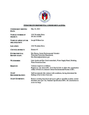
ITEM FOR ENVIRONMENTAL COMMISSION AGENDA COMMISSION MEETING DATE: May 18, 2022 NAME & NUMBER OF PROJECT: 1881 Westlake Drive SP-2021-0349D NAME OF APPLICANT OR ORGANIZATION: Joseph William Lee LOCATION: 1881 Westlake Drive COUNCIL DISTRICT: District #8 ENVIRONMENTAL REVIEW STAFF: Eric Brown, Senior Environmental Scientist Watershed Protection Department, Eric.Brown@austintexas.gov WATERSHED: REQUEST: STAFF RECOMMENDATION: STAFF CONDITION: Lake Austin and Bee Creek watersheds, Water Supply Rural, Drinking Water Protection Zone Variance request is as follows: Request to vary from LDC 25-8-281(C)(2)(b) to allow the construction within 150-foot of a rimrock Critical Environmental Feature (CEF). Staff recommends this variance with conditions, having determined the findings of fact to have been met. Remove existing boat dock and access path as specified on plans; restore disturbed areas per City Standard Specification 609S. All construction to occur via barge. Staff Findings of Fact Watershed Protection Department Staff Recommendations Concerning Required Findings Project Name & Case Number: 1881 Westlake Drive SP-2021-0349D Ordinance Standard: Watershed Protection Ordinance Variance Request: LDC 25-8-281(C)(2)(b) - To allow construction within 150 feet of a Rimrock Critical Environmental Feature (CEF) . Include an explanation with each applicable finding of fact. A. Land Use Commission variance determinations from Chapter 25-8-41 of the City Code: 1. 2. The requirement will deprive the applicant of a privilege available to owners of similarly situated property with approximately contemporaneous development subject to similar code requirements. Yes. A variance from 25-8-281(C)(2)(b) allowing for construction of a boat dock and shoreline access has been granted for similarly situated properties with approximately contemporaneous development subject to similar code. The variance: a) Is not necessitated by the scale, layout, construction method, or other design decision made by the applicant, unless the design decision provides greater overall environmental protection than is achievable without the variance; Yes. No disturbance of the rimrock CEF is proposed, all proposed construction activities are to occur downgradient of the rimrock CEFs, and construction is to occur from the lakeside by barge. The proposed construction to be performed from a barge provides greater overall environmental protection. b) Is the minimum deviation from the code requirement necessary to allow a reasonable use of the property; Yes. The variance is the minimum deviation from the code requirement to allow for a reasonable use of the property. The code requires a 150-foot critical environmental feature buffer. This buffer is not being reduced. The scope of the variance is limited to allowing construction activities to occur within a critical environmental feature buffer only for the proposed boat dock replacement. c) Does not create a significant probability of harmful environmental consequences. Yes. The variance does not create significant harmful environmental consequences. The construction of the boat dock from barge will not disturb the rimrock critical environmental feature. 3. Development with the variance will result in water quality that is at least equal to the water quality achievable without the variance. Yes, the variance will result in water quality that is at least equal to the water quality achievable without the variance. The construction activities will not disturb the rimrock critical environmental features. Staff Recommendation: Staff recommends the variance as the Findings of Fact have been met, with the staff recommended condition that all construction be completed by barge. B. The Land Use Commission may grant a variance from a requirement of Section 25-8- 422 (Water Supply Suburban Water Quality Transition Zone), Section 25-8-452 (Water Supply Rural Water Quality Transition Zone), Section 25-8-482 (Barton Springs Zone Water Quality Transition Zone), Section 25-8-368 (Restrictions on Development Impacting Lake Austin, Lady Bird Lake, and Lake Walter E. Long), or Article 7, Division 1 ( Critical Water Quality Zone Restrictions ), after determining that: The criteria for granting a variance in Subsection (A) are met; 1. 2. 3. Yes / No N/A Yes / No N/A The requirement for which a variance is requested prevents a reasonable, economic use of the entire property; The variance is the minimum deviation from the code requirement necessary to allow a reasonable, economic use of the entire property. Yes / No N/A Staff Recommendation: N/A. Hydrogeologic Reviewer (WPD) ___________________________ Eric Brown Date: 4/29/2022 Deputy Environmental Officer (WPD) _____________________________ Liz Johnston Date: 4/29/2022 Applicant Form and Findings of Fact January 31, 2022 ENVIRONMENTAL COMMISSION VARIANCE APPLICATION FORM PROJECT DESCRIPTION Applicant Contact Information Joseph William Lee 5809 Lookout Mountain Drive Austin, TX 78731 714-608-2852 c/o chris@anderssonwise.com 1881 Westlake Drive SP-2021-0349D 1881 Westlake Drive Eric Brown Variance Case Information Name of Applicant Street Address City State ZIP Code Work Phone E-Mail Address Case Name Case Number Address or Location Environmental Reviewer Name Environmental Resource Management Reviewer Name Applicable Ordinance LDC 25-8-281(C)(2)(b) Watershed Name Lake Austin Watershed Classification ☐Urban ☐ Suburban ☐Water Supply Suburban X Water Supply Rural ☐ Barton Springs Zone City of Austin | Environmental Commission Variance Application Guide 1 Edwards Aquifer Recharge Zone ☐ Barton Springs Segment ☐ Northern Edwards Segment X Not in Edwards Aquifer Zones Edwards Aquifer Contributing Zone Distance to Nearest Classified Waterway Water and Waste Water service to be provided by NA ☐ Yes X No The boat dock is in Lake Austin. Request The variance request is as follows (Cite code references: To allow construction in rimrock CEF setbacks. Existing ________ ________ ________ Proposed _________ _________ _________ 1881 Westlake Drive is a 1- acre homesite on the shoreline of Lake Austin containing a home, dock, and dock access. The current home, dock, and dock access date back to the early seventies. This project proposes to replace a non-compliant dock with a compliant dock and complete necessary repairs to the deteriorating dock access. Attachment 1 contains an aerial photo of the site. It’s located about 1.5 miles northeast of the intersection of Westlake Drive and Redbud Trail. The site contains four rimrock CEFs, all of which are upgradient of the proposed dock. Portions of the dock access are upgradient of the rimrocks, but the LOC is lined in mulch sock to contain any sediment produced by the dock access construction. January 31, 2022 Impervious cover square footage: acreage: percentage: Provide general description of the property (slope range, elevation range, summary of vegetation / trees, summary of the geology, CWQZ, WQTZ, CEFs, floodplain, heritage trees, any other notable or outstanding characteristics of the property) City of Austin | Environmental Commission Variance Application Guide 2 January 31, 2022 Clearly indicate in what way the proposed project does not comply with current Code (include maps and exhibits) FINDINGS OF FACT Project: Ordinance: 1. 2. The limit of construction for the proposed dock and access repairs fall within the rimrock CEF setbacks. Please see Attachment 2 for the Proposed Conditions Site Plan Sheet; Attachment 3 for the Basis of Determination for the Findings of Fact; and Attachment 4 for the Environmental Resource Inventory. As required in LDC Section 25-8-41, in order to grant a variance the Land Use Commission must make the following findings of fact: Include an explanation with each applicable finding of fact. A. Land Use Commission variance determinations from Chapter 25-8-41 of the City Code: The requirement will deprive the applicant of a privilege available to owners of similarly situated property with approximately contemporaneous development subject to similar code requirements. Yes / No Please see Attachment 4, Basis of Determination. The variance: a) Is not necessitated by the scale, layout, construction method, or other design decision made by the applicant, unless the design decision provides greater overall environmental protection than is achievable without the variance; Yes / No Please see Attachment 4, Basis of Determination. b) Is the minimum deviation from the code requirement necessary to allow a reasonable use of the property; Yes / No Please see Attachment 4, Basis of Determination. c) Does not create a significant probability of harmful environmental consequences. Yes / No Please see Attachment 4, Basis of Determination. City of Austin | Environmental Commission Variance Application Guide 3 January 31, 2022 3. Development with the variance will result in water quality that is at least equal to the water quality achievable without the variance. Yes / No Please see Attachment 4, Basis of Determination. B. Additional Land Use Commission variance determinations for a requirement of Section 25-8-422 (Water Quality Transition Zone), Section 25-8-452 (Water Quality Transition Zone), Article 7, Division 1 (Critical Water Quality Zone Restrictions), or Section 25-8-368 (Restrictions on Development Impacting Lake Austin, Lady Bird Lake, and Lake Walter E. Long): 1. The criteria for granting a variance in Subsection (A) are met; Not Applicable 2. 3. Yes / No [provide summary of justification for determination] The requirement for which a variance is requested prevents a reasonable, economic use of the entire property; Yes / No [provide summary of justification for determination] The variance is the minimum deviation from the code requirement necessary to allow a reasonable, economic use of the entire property. Yes / No [provide summary of justification for determination] **Variance approval requires all above affirmative findings. City of Austin | Environmental Commission Variance Application Guide 4 January 31, 2022 A Exhibits for Commission Variance o Aerial photos of the site o Site photos o Aerial photos of the vicinity o Context Map—A map illustrating the subject property in relation to developments in the vicinity to include nearby major streets and waterways o Topographic Map - A topographic map is recommended if a significant grade change on the subject site exists or if there is a significant difference in grade in relation to adjacent properties. o For cut/fill variances, a plan sheet showing areas and depth of cut/fill with topographic elevations. o Site plan showing existing conditions if development exists currently on the property o Proposed Site Plan- full size electronic or at least legible 11x17 showing proposed development, include tree survey if required as part of site or subdivision plan o Environmental Map – A map that shows pertinent features including Floodplain, CWQZ, WQTZ, CEFs, Setbacks, Recharge Zone, etc. o An Environmental Resource Inventory pursuant to ECM 1.3.0 (if required by 25-8-121) o Applicant’s variance request letter City of Austin | Environmental Commission Variance Application Guide 5 Applicant Exhibits January 31, 2022 ATTACHMENT 1 AERIAL SITE PHOTO City of Austin | Environmental Commission Variance Application Guide 6 January 31, 2022 ATTACHMENT 2 PROPOSED CONDITIONS SITE PLAN SHEET AND EROSION CONTROLS City of Austin | Environmental Commission Variance Application Guide 7 NOTES: 1. ALL WORK SHALL OCCUR WITHIN THE LIMITS OF CONSTRUCTION AS SHOWN ON THE PLAN. ALL MATERIALS WILL BE TRANSPORTED TO THE SITE FROM WATER. ALL CONSTRUCTION ACTIVITY, INCLUDING STAGING AND SPOIL STORAGE, WILL BE COMPLETED BY WATER. 2. SHORELINE IMPROVEMENTS, INCLUDING GANGWAY ACCESS, ARE AUTHORIZED WITH THIS SITE PLAN. 3. CONTAINERS OF HAZARDOUS MATERIALS, FUEL, OIL, HERBICIDES, INSECTICIDES, 4. FERTILIZERS, OR OTHER POLLUTANTS WILL NOT BE STORED ON DOCKS EXTENDING INTO OR ABOVE LAKE AUSTIN. FOR LA ZONING, PERMANENT IMPROVEMENTS ARE PROHIBITED WITHIN THE SHORELINE SETBACK AREA, EXCEPT FOR RETAINING WALLS, PIERS, WHARVES, BOATHOUSES, MARINAS, OR A DRIVE TO ACCESS THE STRUCTURES [LDC 25-2-551 (B)(2)]. 5. NO WATER OR WASTEWATER UTILITIES ARE PROPOSED WITH THIS DEVELOPMENT. 6. DOCK SHALL BE AT LEAST 66% OPEN. 7. PILINGS SHALL BE 6-5/8" DIAMETER STEEL PIPE. 8. THE PROJECT SITE IS WITHIN THE CITY OF AUSTIN LIMITED PURPOSE BOUNDARIES. ATTENTION INSPECTOR NOTES: 1. COMPLIANCE WITH BUILDING CODE REQUIRED AND IS TO BE REVIEWED FOR 2. COMPLIANCE DURING BUILDING CODE REVIEW. FOR THE BUILDING PERMIT, A SIGNED AND SEALED LETTER SHALL BE SUBMITTED TO THE CITY OF AUSTIN, PER THE LAND DEVELOPMENT CODE, 25-12-3 1612.4, CERTIFYING THAT THE STRUCTURE IS IN ACCORDANCE WITH ASCE 24, FLOOD RESISTANT DESIGN AND CONSTRUCTION. 3. ENVIRONMENTAL INSPECTOR HAS THE AUTHORITY TO ADD AND/OR MODIFY EROSION/SEDIMENTATION CONTROLS ON SITE TO KEEP PROJECT IN COMPLIANCE WITH THE CITY OF AUSTIN RULES AND REGULATIONS. 1881 WESTLAKE DRIVE SHORELINE MITIGATION PLANTING SCHEDULE NUMBER OF PLANTS TYPE OF MITIGATION PLANT NAME Bald Cypress (Taxodium distichum)** Mexican Plum (Prunus mexicana)** White Mistflower (Ageratina havanensis)^ Barbados Cherry (Malpighia glabra)^ 1 1 2 2 TOTAL = 6 PLANTS Floodplain Floodplain Floodplain Floodplain 2" caliper trees Native shrub with low water needs ** ^ Alternative native and adapted species may be substituted with the same quantity of another species and plant planting location maybe modified as approved by the PDR Environmental reviewer, ERM Wetland Biologist or ERM Landscape Architect. TOTAL 609S SHRUBS REQUIRED = 4 SHRUBS. 4 SHRUBS ARE PROPOSED TOTAL 609S UNDERSTORY TREES REQUIRED = 1 TREE. 1 UNDERSTORY TREE IS PROPOSED TOTAL 609S SHADE TREES REQUIRED = 1 TREE. 1 SHADE TREE IS PROPOSED TOTAL 609S PLANTS REQUIRED = 6 PLANTS. 6 PLANTS PROPOSED REMOVED DDI APPENDIX F INCHES REMOVED DDI HERITAGE INCHES REMOVED DDI NON-APPENDIX F INCHES REMOVED DDI INVASIVE INCHES REMOVED SURVEYED TOTAL APPENDIX F TREE INCHES SURVEYED HERITAGE TREE INCHES SURVEYED NON-APPENDIX F TREE INCHES SURVEYED INVASIVE TREE INCHES SURVEYED MITIGATION TOTAL MITIGATION REPLACEMENT INCHES PLANTED 0.0 TOTAL REPLACEMENT INCHES PLANTED ON SITE (PRIVATE TREES) 0.0 0.0 TOTAL REPLACEMENT ROW INCHES PLANTED 0.0 PRIVATE INCHES OWED TO UFRF PUBLIC INCHES OWED TO UFRF 0.0 TOTAL NON-MITIGATION INCHES PLANTED ON-SITE (ECM 3.5.4) 4.0 0.0 0.0 0.0 0.0 1052.0 25.0 27.5 27.5 PLANTING MITIGATION CALCULATIONS 609S RESTORATION · ALL DISTURBED AREAS WITHIN THE SHORELINE SETBACK SHALL BE REVEGETATED PURSUANT TO 609S SPECIFICATIONS, USING 609S SEEDING OR PLANTING AREA OF IMPACT IS APPROXIMATELY 430 SF PLANTING CRITERIA RECOMMENDS 1 NATIVE SHADE TREE AND 1 NATIVE UNDERSTORY TREE/500 SF OF DISTURBED AREA 430 SF/500 SF = 1 SHADE TREE AND 1 UNDERSTORY TREE AND 1 NATIVE SHRUB/100 SF 430 SF/100 = 4 SHRUBS PLANTING MITIGATION NOTES ALL PLANTS TO BE SOURCED WITHIN A 200 MILE RADIUS OF AUSTIN. FOLLOW ALL GUIDELINES FOUND IN THE CITY OF AUSTIN ENVIRONMENTAL CRITERIA MANUAL, REFERENCE CODE SECTIONS ECM 1.13.0, ECM 1.10.4(D), & ITEM NO. 609S AS APPLICABLE ALL PLANTS TO BE A MINIMUM OF ONE GALLON PLANTS INSTALLED AT A MAXIMUM OF 3FT ON CENTERS. · · · · · · NOTE: THE PROPOSED BOAT DOCK MUST COMPLY WITH ALL REQUIREMENTS OF LDC 25-2-1174 (“STRUCTURAL REQUIREMENTS”), AND MUST COMPLY WITH CHAPTER 25-12, ARTICLE 1 (UNIFORM BUILDING CODE) AND THE BUILDING CRITERIA MANUAL. EXISTING SHORELINE LENGTH = 127.9' ALLOWABLE DOCK WIDTH = 25.6 PROPOSED DOCK WIDTH = 25.5' PROPOSED DOCK DEPTH = 41.3' DOCK FOOTPRINT = 657.1 SF CHANNEL WIDTH = 116.7' ALLOWABLE DOCK EXTENSION = 23.3' X X X X X X X X X 9652 RIMROCK 2 CEF MEXICAN PLUM BALD CYPRESS EXISTING = PROPOSED SHORELINE ELEV 492.8 100-YR FLOODPLAIN/BFE ELEV = 493.0 RIMROCK 2 CEF SETBACK INSTALL MULCH SOCK APPROX. 47.2 LF LIMITS OF CONSTRUCTION LOC FSS LOC FSS LOC FSS LOC FSS LOC FSS FLOATING SILT SCREEN APPROX. 112.2 LF LOC LOC LOC LOC LOC LOC LOC PROPOSED BOAT DOCK 25.5' X 36.4' NO DREDGING PROPOSED SEE THIS SHEET FOR DOCK PLAN/ELEVATION VIEWS C O L 71 WHITE MISTFLOWER OR BARBADOS CHERRY 75' LA AND CWQZ SETBACK PROPOSED LANDSCAPE WALL TO ALIGN WITH NEW ACCESS PATH MAX LANDSCAPE WALL HEIGHT = 3' APPROX. 20.3' TOP OF WALL = EXISTING GRADE 5 3 5 0 3 5 74 PROPOSED ACCESS INSTALL TREE BOARDS 76 75 77 9651 9653 9654 5 5 5 S M / C O L 0 5 5 S M C O L / S C/M O L S C/M O L S C/M O L 5 4 5 S M / C O L 0 4 5 PROPOSED LANDSCAPE WALL TO ALIGN WITH NEW ACCESS PATH 72 MAX LANDSCAPE WALL HEIGHT = 3' APPROX. 7.6 TOP OF WALL = EXISTING GRADE' 73 LOC/MS LOC/MS 23.0' 79 5 0 5 S C/ M L O S C/ M L O S M / C O L S C/ M L O S C / M L O S C/ M L O 0 0 5 81 XX S M / C O L XX LOC/MS LOC/MS 3.0' 41.3' 0 6 5 INSTALL TREE BOARDS INSTALL TREE BOARDS S C/M LO S C/M O L / S M C O L S C/M LO S M / C O L S M / C O L 5 2 5 609 REVEGETATION/EROSION CONTROL MATTING INSTALL SOIL RETENTION MATTING PER COA STANDARD SPECIFICATION 605S 0 2 5 C / M S O L LOC/MS LOC/MS S M C/ O L S C / M O L S C / M O L LOC/MS LOC/MS LOC/MS XX C/MS LO XX LOC/MS 63 REPAIR ACCESS PATH AS NEEDED LOC/MS S M / C O L S M / C O L S M / C O L XX S M / C O L XX 64 LOC/MS INSTALL TREE BOARDS INSTALL TREE BOARDS S C/M O L XX XX S 65 C/M O L 61 62 S C/ M L O LOC/MS S M / C O L XX 66 XX LOC/MS 0 1 5 5 1 5 S C/ M L O S C/ M L O S C/M O L S C/M O L INSTALL TREE BOARDS REPAIR EXISTING LANDSCAPE WALL IF NEEDED S S F THE PORTION OF THE LIMITS OF CONSTRUCTION ON THE SHORE LIES IN THE CWQZ. THIS AREA REQUIRES NATIVE GRASSLAND SEEDING AND PLANTING PER CITY OF AUSTIN STANDARD SPECIFICATION 609S, INCLUDING TOPSOIL AND SEED BED PREPARATION, TEMPORARY IRRIGATION, AND WEED MAINTENANCE S S F C O L LOC LOC FSS LOC FSS LOC FSS LOC FSS LOC FSS LOC S S F FSS LOC FSS LOC RIMROCK 4 CEF LOC LOC LOC LOC LOC LOC LOC RIMROCK 1 CEF SETBACK C O L C O L C O L C O L C O L C O L C O L C O L C O L C O L C O L S S F S S F S S F S S F 25.5' S S F S S F S S F S S F LOC/MULCH SOCK INSTALL MULCH SOCK APPROX. 312.8 LF X X X X X X X X X X X X X X X X X X X X X X X X X X X X X X X X X X X X X X X 70 67 68 5 9 4 9 8 4 4 9 4 69 0 9 4 X X X X X X X X X X RIMROCK 1 CEF RIMROCK 3 CEF SETBACK C L O XX XX 78 C O L C O L C O L C O L C O L C O L TREE 1 4 CRZ TREE 1 2 CRZ TREE CEF PROPOSED DOCK PLAN/ELEVATION VIEWS LEGEND EXISTING = PROPOSED SHORELINE FEMA 100-YR FLOODPLAIN/BFE 75' LA AND CWQZ SETBACK RIMROCK CEF RIMROCK CEF SETBACK TREE PROTECTION FLOATING SILT SCREEN PROPOSED DOCK 609S REVEGETATION/EROSION CONTROL MATTING XX FSS XX FSS LOC/MS LOC/MS LIMIT OF CONSTRUCTION/MULCH SOCK LOC LOC LIMIT OF CONSTRUCTION PROPOSED CONDITIONS 10 5 0 10 20 TREE # TREE CRITICAL ROOT ZONE, 1 AND 1 4 CRZ 2 CRZ, SCALE: 1" = 20' ' D V P P A I N O S V E R I E T A D . O N 1 2 0 2 / 1 3 / 1 0 C L L , g n i t l u s n o C h t i m S s i n a J I E V R D E K A L T S E W 1 8 8 1 9 2 7 3 - 4 1 9 - 2 1 5 3 0 7 8 7 s a x e T , n i t s u A d a o R r e v o t s e W 5 0 5 1 8 7 9 6 1 - F r e b m u N n o i t a r t s i g e R s r e e n i g n E l a n o i s s e f o r P f o d r a o B s a x e T I I I N A L P E T S S N O T D N O C D E S O P O R P D 9 4 3 0 - 1 2 0 2 - P S - I E V R D E K A L T S E W 1 8 8 1 DESIGNED: JJS APPROVED: SCALE: AS SHOWN 1881 WESTLAKE DRIVE DATE: SEPT 25, 2021 SHEET of 4 3 3 SP-2021-0349D January 31, 2022 BASIS OF DETERMINATION FOR THE FINDINGS OF FACT ATTACHMENT 3 City of Austin | Environmental Commission Variance Application Guide 8 A. 1. The requirement will deprive the applicant of a privilege available to owners of similarly situated property with approximately contemporaneous development subject to similar code requirements. YES. The Environmental Commission has recommended every variance application pertaining to LDC 25-8-281(C)(2)(b) for the past six years except for one which included a tram. 2. The variance: a. Is not necessitated by the scale, layout, construction method, or other design decision made by the applicant, unless the design decision provides greater overall environmental protection than is achievable without the variance; YES. The entire shoreline is within the CEF setback. Any dock constructed at this site will require this variance. b. Is the minimum deviation from the code requirement necessary to allow reasonable use of the property; YES. A dock cannot be constructed on the lot without obtaining this variance. c. Does not create a significant probability of harmful environmental consequences. YES. None of the rimrock CEFs are in the LOC, and mulch sock and floating silt screen will be deployed to contain all sediment within the LOC. Post construction, all disturbed areas will be revegetated per the COA 609S specification. 3. Development with the variance will result in water quality that is at least equal to the water quality achievable without the variance. YES. Mitigation plantings will be added to the site which should result in a greater water quality from overland flow entering the lake. Repairing the fragile and deteriorating dock access should reduce rocks and debris flowing down the hillside. The floating silt screen should contain any sediment caused by the boat dock construction. B. 1. The criteria for granting a variance in Subsection (A) are met: YES. Please see answers to A (1), (2), and (3). 2. The requirement for which a variance is requested prevents a reasonable, economic use of the entirety of the property; YES. The boat dock and portions of the dock access are unsafe and in need of repair. A safe dock can’t be permitted without this variance, nor can the dock access be repaired. The stone steps down to the dock provide access to the entire slope down to the lake – about a third of the lot. Denying the owner the ability to construct a safe dock and access to a third of the lot “prevents a reasonable, economic use of the entirety of the property”. 3. The variance is the minimum deviation from the code requirement necessary to allow a reasonable, economic use of the entire property; YES. The construction is limited to replacing a deteriorating dock and dock access with a safe dock and dock access. No further work is proposed; so this project “is the minimum deviation from the code”. Denying the owner the ability to construct a safe dock and access to a third of the lot “prevents a reasonable, economic use of the entirety of the property”. January 31, 2022 ATTACHMENT 4 ENVIRONMENTAL RESOURCE INVENTORY City of Austin | Environmental Commission Variance Application Guide 9 City of Austin – Environmental Resource Inventory (ERI) 1881 Westlake Dr Travis County, Texas May 14, 2021, Revised December 16, 2021 By: DESCO Environmental Consultants, LP 26902 Nichols Sawmill Road Magnolia, Texas 77355 DESCO Environmental Consultants, LP Natural Resources | Environmental Planning | GIS | Cultural Resources | Regulatory Permitting & Compliance 26902 Nichols Sawmill Road, Magnolia, TX 77355 | 281.252.9799 | www.descoenv.com Case No.: (City use only) Environmental Resource Inventory For the City of Austin Related to LDC 25-8-121, City Code 30-5-121, ECM 1.3.0 & 1.10.0 The ERI is required for projects that meet one or more of the criteria listed in LDC 25-8-121(A), City Code 30-5-121(A). 1. SITE/PROJECT NAME: 1881 Westlake Drive 2. COUNTY APPRAISAL DISTRICT PROPERTY ID (#’s): 119788 3. ADDRESS/LOCATION OF PROJECT: 1881 Westlake Drive, Austin, TX 78746 4. WATERSHED: Lake Austin 5. THIS SITE IS WITHIN THE (Check all that apply) Edwards Aquifer Recharge Zone* (See note below) .................. (cid:133)YES (cid:133)No Edwards Aquifer Contributing Zone*.................................. (cid:133)YES (cid:133)No Edwards Aquifer 1500 ft Verification Zone* ....................... (cid:133)YES (cid:133)No Barton Spring Zone* .......................................................... (cid:133)YES (cid:133)No *(as defined by the City of Austin – LDC 25-8-2 or City Code 30-5-2) ✔ ✔ ✔ ✔ Note: If the property is over the Edwards Aquifer Recharge zone, the Hydrogeologic Report and karst surveys must be completed and signed by a Professional Geoscientist Licensed in the State of Texas. 6. DOES THIS PROJECT PROPOSE FLOODPLAIN MODIFICATION?.......(cid:133)YES** (cid:133)NO ✔ If yes, then check all that apply: (cid:13) (1) The floodplain modifications proposed are necessary to protect the public health and safety; (cid:13) (2) The floodplain modifications proposed would provide a significant, demonstrable environmental benefit, as determined by a functional assessment of floodplain health as prescribed by the Environmental Criteria Manual (ECM), or (cid:13) (3) The floodplain modifications proposed are necessary for development allowed in the critical water quality zone under LDC 25-8-261 or 25-8-262, City Code 30-5-261 or 30-5-262. (cid:13) (4) The floodplain modifications proposed are outside of the Critical Water Quality Zone in an area determined to be in poor or fair condition by a functional assessment of floodplain health. ** If yes, then a functional assessment must be completed and attached to the ERI (see ECM 1.7 and Appendix X for forms and guidance) unless conditions 1 or 3 above apply. 7. IF THE SITE IS WITHIN AN URBAN OR SUBURBAN WATERSHED, DOES THIS PROJECT PROPOSE A UTILITY LINE PARALLEL TO AND WITHIN THE CRITICAL WATER QUALITY ZONE? ......................................................... (cid:133)YES*** (cid:133)NO ✔ ***If yes, then riparian restoration is required by LDC 25-8-261(E) or City Code 30-5-261(E) and a functional assessment must be completed and attached to the ERI (see ECM1.5 and Appendix X for forms and guidance). 4 8. There is a total of (#’s) Critical Environmental Feature(s)(CEFs) on or within150 feet of the project site. If CEF(s) are present, attach a detailed DESCRIPTION of the CEF(s), color PHOTOGRAPHS, the CEF WORKSHEET and provide DESCRIPTIONS of the proposed CEF buffer(s) and/or wetland mitigation. Provide the number of each type of CEFs on or within 150 feet of the site (Please provide the number of CEFs ): 0 (#’s) Spring(s)/Seep(s) (#’s) Point Recharge Feature(s) 4 (#’s) Canyon Rimrock(s) (#’s) Wetland(s) 0 0 0 (#’s) Bluff(s) Note: Standard buffers for CEFs are 150 feet, with a maximum of 300 feet for point recharge features. Except for wetlands, if the standard buffer is not provided, you must provide a written request for an administrative variance from LDC 25-8-281(C)(1) and provide written findings of fact to support your request. Request forms for administrative variances from requirements stated in LDC 25-8-281 are available from Watershed Protection Department. 9. The following site maps are attached at the end of this report (Check all that apply and provide): All ERI reports must include: (cid:13) Site Specific Geologic Map with 2-ft Topography x (cid:13) Historic Aerial Photo of the Site x (cid:13) Site Soil Map x (cid:13) Critical Environmental Features and Well Location Map on current x Aerial Photo with 2-ft Topography Only if present on site (Maps can be combined): (cid:13) Edwards Aquifer Recharge Zone with the 1500-ft Verification Zone(cid:3) (cid:3) (cid:3) (Only if site is over or within 1500 feet the recharge zone) (cid:13) Edwards Aquifer Contributing Zone(cid:3) (cid:13) Water Quality Transition Zone (WQTZ) (cid:13) Critical Water Quality Zone (CWQZ)(cid:3) x (cid:13) City of Austin Fully Developed Floodplains for all water courses with x (cid:3) (cid:3) (cid:3) (cid:3) (cid:3) (cid:3) (cid:3) (cid:3) (cid:3) (cid:3) up to 64-acres of drainage 10. HYDROGEOLOGIC REPORT – Provide a description of site soils, topography, and site specific geology below (Attach additional sheets if needed): Surface Soils on the project site is summarized in the table below and uses the SCS Hydrologic Soil Groups*. If there is more than one soil unit on the project site, show each soil unit on the site soils map. Soil Series Unit Names, Infiltration Characteristics & Thickness *Soil Hydrologic Groups Definitions (Abbreviated) Soil Series Unit Name & Subgroup** Group* Thickness (feet) Brackett soils and Urban land, 12 to 30 percent slopes Eckrant soils and Urban land, 18 to 40 percent slopes D D 1.5 0.67 A. Soils having a high infiltration rate when thoroughly wetted. B. Soils having a moderate infiltration rate when thoroughly wetted. C. Soils having a slow infiltration rate when thoroughly wetted. D. Soils having a very slow infiltration rate when thoroughly wetted. **Subgroup Classification – See Classification of Soil Series Table in County Soil Survey. WPD ERM ERI-2014-01 Page 2 of 6 Description of Site Topography and Drainage (Attach additional sheets if needed): The property is sloped and drains from north northeast to south southwest toward Lake Austin in the Lake Austin watershed, downstream of Lake Travis. The average slope of the property is approximately 20 percent, with the steeper sloped areas being present closer to Lake Austin. The property is bordered on the north, east, and west by similar residential properties and Lake Austin to the south. At the time of the site visit the property had a main residence, outbuilding, greenhouse, and boat dock. The entire shoreline with Lake Austin is a stone/concrete bulkhead with no fringe wetlands. A total of four rimrock CEFs were located on the property. Rimrock 1 had previously been documented by the City of Austin and verified during the site visit. Rimrock 2, Rimrock 3, and Rimrock 4 were documented during the site visit on May 10, 2021. Rimrock 2 extends well past the mapped location to the southeast onto the neighboring property. List surface geologic units below: Geologic Units Exposed at Surface Group Trinity Formation Upper Glen Rose Member Cretaceous Brief description of site geology (Attach additional sheets if needed): Upper Glen Rose Formation- limestone, dolomite, and marl in alternating resistant and recessive beds forming stairstep topography; limestone, aphanitic to fine-grained, hard to soft and marly, light-gray to yellowish-gray; dolomite, fine-grained, porous, yellowish-brown; marine megafossils including molluscan steinkems, rudistids, oysters, and echinoids; upper part relatively thinner bedded, more dolomitic and less fossiliferous than lower part, thickness about 220 feet. Wells – Identify all recorded and unrecorded wells on site (test holes, monitoring, water, oil, unplugged, capped and/or abandoned wells, etc.): There are (#) wells present on the project site and the locations are shown and labeled (#’s)The wells are not in use and have been properly abandoned. 0 0 There are (#’s)The wells are not in use and will be properly abandoned. (#’s)The wells are in use and comply with 16 TAC Chapter 76. (#’s) wells that are off-site and within 150 feet of this site. 0 0 0 WPD ERM ERI-2014-01 Page 3 of 6 11. THE VEGETATION REPORT – Provide the information requested below: Brief description of site plant communities (Attach additional sheets if needed): The majority of the site is woodland dominated by live oak (Quercus virginiana), net-leaf hackberry (Celtis reticulata), eastern red-cedar (Juniperus virginiana), Shumard oak (Quercus shumardii), and Texas persimmon (Diospyros texana). There is a small maintained yard in the front of the residence dominated by St. Augustine grass (Stenotaphrum secundatum). No grassland/prairie/ savanna or hydrophytic vegetation is present on the property. There is woodland community on site …………………….(cid:133)YES (cid:133) NO (Check one). If yes, list the dominant species below: ■ Woodland species Common Name Live Oak Net-leaf Hackberry Eastern Red-cedar Shumard Oak Texas Persimmon Scientific Name Quercus virginiana Celtis reticulata Juniperus virginiana Quercus shumardii Diospyros texana There is grassland/prairie/savanna on site……………..(cid:133)YES (cid:133) NO (Check one). If yes, list the dominant species below: ■ Grassland/prairie/savanna species Common Name Scientific Name There is hydrophytic vegetation on site ………………..(cid:133)YES (cid:133) NO (Check one). If yes, list the dominant species in table below (next page): ■ WPD ERM ERI-2014-01 Page 4 of 6 Hydrophytic plant species Common Name Scientific Name Wetland Indicator Status A tree survey of all trees with a diameter of at least eight inches measured four and one- half feet above natural grade level has been completed on the site. (cid:3) (cid:133)YES (cid:133) NO (Check one). ■ 12. WASTEWATER REPORT – Provide the information requested below. Wastewater for the site will be treated by (Check of that Apply): (cid:13) On-site system(s) (cid:13) City of Austin Centralized sewage collection system (cid:13) Other Centralized collection system x Note: All sites that receive water or wastewater service from the Austin Water Utility must comply with City Code Chapter 15-12 and wells must be registered with the City of Austin The site sewage collection system is designed and will be constructed to in accordance to all State, County and City standard specifications. (cid:3) (cid:133)YES (cid:133) NO (Check one). ■ Calculations of the size of the drainfield or wastewater irrigation area(s) are attached at the end of this report or shown on the site plan. (cid:133)YES (cid:133) NO (cid:133) Not Applicable (Check one). ■ Wastewater lines are proposed within the Critical Water Quality Zone? (cid:3) (cid:133)YES (cid:133) NO (Check one). If yes, then provide justification below: ■ WPD ERM ERI-2014-01 Page 5 of 6 Is the project site is over the Edwards Aquifer? (cid:133)YES (cid:133) NO (Check one). ■ If yes, then describe the wastewater disposal systems proposed for the site, its treatment level and effects on receiving watercourses or the Edwards Aquifer. 13. One (1) hard copy and one (1) electronic copy of the completed assessment have been provided. Date(s) ERI Field Assessment was performed: May 10, 2021 Date(s) My signature certifies that to the best of my knowledge, the responses on this form accurately reflect all information requested. Chris Little Print Name Signature re 281-252-9799 Telephone clittle@descoenv.com Email Address DESCO Environmental Consultants, LP May 14, 2021, revised December 16, 2021 Name of Company Date For project sites within the Edwards Aquifer Recharge Zone, my signature and seal also certifies that I am a licensed Professional Geoscientist in the State of Texas as defined by ECM 1.12.3(A). P.G. Seal WPD ERM ERI-2014-01 Page 6 of 6 City of Austin Environmental Resource Inventory - Critical Environmental Feature Worksheet 1 2 3 4 9 Project Name: 1881 Westlake Drive Project Address: 1881 Westlake Drive, Austin, Texas 78746 Site Visit Date: May 10, 2021 Environmental Resource Inventory Date: May 14, 2021, revised December 16, 2021 5 6 7 8 Primary Contact Name: Chris Little Phone Number: 281-252-9799 Prepared By: Chris Little Email Address: clittle@descoenv.com FEATURE TYPE {Wetland,Rimrock, Bluffs,Recharge Feature,Spring} FEATURE ID (eg S-1) FEATURE LONGITUDE (WGS 1984 in Meters) FEATURE LATITUDE (WGS 1984 in Meters) WETLAND DIMENSIONS (ft) RIMROCK/BLUFF DIMENSIONS (ft) coordinate notation coordinate notation X Y Length Avg Height RECHARGE FEATURE DIMENSIONS Y Z Trend X Springs Est. Discharge cfs Rimrock (CoA) Rimrock 1 616146.39749 Rimrock Rimrock Rimrock Rimrock 2 616170.60456 Rimrock 3 616187.65272 Rimrock 3 616147.34283 3352696.71293 3352682.83614 3352719.53092 3352671.28783 61.5 50+ 100.7 71.1 6 10 5 8 City of Austin Use Only CASE NUMBER: For rimrock, locate the midpoint of the segment that describes the feature. For wetlands, locate the approximate centroid of the feature and the estimated area. For a spring or seep, locate the source of groundwater that feeds a pool or stream. DMS DD YES NO Wetland Rimrock Recharge Feature Spring Seep Please state the method of coordinate data collection and the approximate precision and accuracy of the points and the unit of measurement. Method Accuracy GPS Surveyed Other sub-meter (cid:3508) x (cid:3508) (cid:3508) Professional Geologists apply seal below (cid:3508) x (cid:3508) (cid:3508) > 1 meter meter WPD ERM ERI-CEF-01 Page 7 of 8 List of Attachments for the Environmental Resource Inventory Form Figure 1: Site Specific Geological Map with 2’ Topography Figure 2: Historical Aerial Imagery Figure 3: Site Soils Map Figure 4: Critical Environmental Features and Well Locations Figure 5: CWQZ and Fully Developed Floodplain Figure 6: 1881 Westlake Drive - ERI Site Photos DESCO – ERI – 1881 Westlake Drive – Austin, Texas Kgru Legend 2' Contours (CoA) Geologic Atlas of Texas - 250K (TNRIS) Parcel of Interest (CoA) Figure 1: Site Specific Geologic Map with 2' Topography 1881 Westlake Dr. Geologic Formation Kgru: Upper Glen Rose Formation ¯ 1:800 Travis County, Texas Map Base: 2020 CAP Area Imgery from TNRIS Map Datum: NAD 1983 UTM Zone 14N, meters Map Date: May 11, 2021 0 25 50 100 Feet Legend Parcel of Interest (CoA) Figure 2: Historical Aerial Imagery 1881 Westlake Dr. Travis County, Texas Map Base: 1996 TOP CIR Aerial Imagery from TNRIS Map Datum: NAD 1983 UTM Zone 14N, meters Map Date: May 11, 2021 ¯ 1:800 0 25 50 100 Feet BrF TeF Legend Parcel of Interest (CoA) Soils (USDA/NRCS) Figure 3: Site Soils Map 1881 Westlake Dr. Travis County, Texas Map Base: 2020 CAP Area Aerial Imagery from TNRIS Map Datum: NAD 1983 UTM Zone 14N, meters Map Date: May 11, 2021 0 25 50 100 Feet Soils BrF: Brackett soils and Urban land, 12 to 30 percent slopes TeF: Eckrant soils and Urban land, 18 to 40 percent slopes ¯ 1:800 Rimrock 3 Rimrock 2 Rimrock 1 Rimrock 4 Legend Rimrock (CoA) Rimrock (DESCO) Parcel of Interest (CoA) 150' Rimrock Buffer Figure 4: Critical Environmental Features and Well Locations 1881 Westlake Dr. No Wetlands or Wells on this Map ¯ 1:800 Travis County, Texas Map Base: 2020 CAP Area Aerial Imagery from TNRIS Map Datum: NAD 1983 UTM Zone 14N, meters Map Date: December 13, 2021 0 25 50 100 Feet L A K E A U S T I N Legend Creeks (CoA) CWQZ (CoA) Parcel of Interest (CoA) Austin Fully Developed Floodplain (CoA) Lakes (CoA) Figure 5: CWQZ and Fully Developed Floodplain Map 1881 Westlake Dr. ¯ 1:800 Travis County, Texas Map Base: 2020 CAP Area Aerial Imagery from TNRIS Map Datum: NAD 1983 UTM Zone 14N, meters Map Date: May 11, 2021 0 25 50 100 Feet Figure 6. 1881 Westlake Drive ERI Site Photos Photo 1: Driveway of property adjacent to Westlake drive. Photo is facing northeast toward Westlake Drive. Photo 2: View of property facing main residence, with outbuilding and greenhouse to left. Photo was taken from upper portion of driveway facing south southwest. Photo 3: Photo of outbuilding on upper portion of property near Westlake Drive facing east. Photo 4: Photo of Rimrock 1 which had previously been documented by the City of Austin and verified by DESCO during the site visit. Photo was taken from near the east end of the rimrock facing northwest. Photo 5: View of Rimrock 2 which extends further southeast than mapped. Photo was taken near the eastern property boundary facing northeast. Photo 6: View of Rimrock 3, just above the main residence facing southeast. Photo 7: View of western shoreline and Rimrock 4 from boat dock with no fringe wetlands facing northwest. Photo 8: View of eastern shoreline from boat dock with no fringe wetlands facing east.