20220518-004b: Crossroads Logistics Center Additions — original pdf
Backup
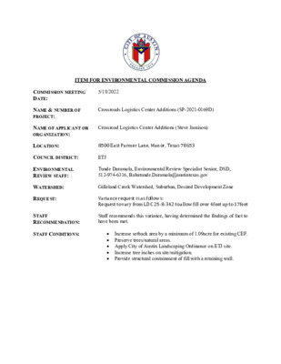
ITEM FOR ENVIRONMENTAL COMMISSION AGENDA COMMISSION MEETING DATE: 5/18/2022 NAME & NUMBER OF PROJECT: NAME OF APPLICANT OR ORGANIZATION: Crossroads Logistics Center Additions (SP-2021-0169D) Crossroad Logistics Center Additions (Steve Jamison) LOCATION: 8500 East Parmer Lane, Manor, Texas 78653 COUNCIL DISTRICT: ETJ ENVIRONMENTAL REVIEW STAFF: Tunde Daramola, Environmental Review Specialist Senior, DSD, 512-974-6316, Babatunde.Daramola@austintexas.gov WATERSHED: REQUEST: STAFF RECOMMENDATION: STAFF CONDITIONS: Gilleland Creek Watershed, Suburban, Desired Development Zone Variance request is as follows: Request to vary from LDC 25-8-342 to allow fill over 4feet up to 17feet Staff recommends this variance, having determined the findings of fact to have been met. Increase setback area by a minimum of 1.09acre for existing CEF. Preserve trees/natural areas. Apply City of Austin Landscaping Ordinance on ETJ site. Increase tree inches on site/mitigation. Provide structural containment of fill with a retaining wall. Development Services Department Staff Recommendations Concerning Required Findings Project Name: Ordinance Standard: Watershed Protection Ordinance Variance Request: Crossroads Logistics Center Additions To allow for fill exceeding 4 feet up to 17 feet for building construction Include an explanation with each applicable finding of fact. A. Land Use Commission variance determinations from Chapter 25-8-41 of the City Code: 1. The requirement will deprive the applicant of a privilege available to owners of similarly situated property with approximately contemporaneous development subject to similar code requirements. Yes. The variance will not be providing a special privilege to the applicant. The proposed buildings are similar in size to similarly situated property. In order to facilitate this type of development, significant levelling is required to enhance maneuverability into the loading docks, allowing trucks to operate safely on site. The limits of the fill do extend beyond the building as shown in the cut/fill exhibit but is contained with a retaining wall structure designed in conjunction with the building walls, so the building is supported. Prior projects in this industrial development zone had a similar situation. A prime example is Park 183 Buildings 6 & 7, SP-2021-0072C. A Land Use Commission variance was granted to LDC 25-8-342 to allow cut and fill up to 17 feet. 2. The variance: a) Is not necessitated by the scale, layout, construction method, or other design decision made by the applicant, unless the design decision provides greater overall environmental protection than is achievable without the variance; Yes. The industrial use for this project requires level loading docks, parking, and drive aisles. Existing site conditions necessitates additional fill for providing the required level fire lane and loading dock areas that require less than 4% grades. Effective accessibility to portions of the building would not be achievable without this variance. b) Is the minimum deviation from the code requirement necessary to allow a reasonable use of the property; Yes. There is significant fall across the property which poses challenges with cut/fill for a large single finished floor building. In order to facilitate this type of development, a minimum deviation from code to allow fill up to 17 feet is necessary. Structural containment will also be provided to contain and minimize the amount of fill. c) Does not create a significant probability of harmful environmental consequences. The variance does not create a significant probability of harmful Yes. consequences. The variance is a minimum deviation from code to allow for reasonable use of the property. The fill will be minimized and structurally contained with a retaining wall. Retaining wall will also reduce the amount of sloping required to return to existing grade. 3. Development with the variance will result in water quality that is at least equal to the water quality achievable without the variance. Yes. The project is served by three water quality and detention ponds and one rain garden designed to treat this development. The development is compliant with current code. B. The Land Use Commission may grant a variance from a requirement of Section 25-8-422 (Water Supply Suburban Water Quality Transition Zone), Section 25-8-452 (Water Supply Rural Water Quality Transition Zone), Section 25-8-482 (Barton Springs Zone Water Quality Transition Zone), Section 25-8-368 (Restrictions on Development Impacting Lake Austin, Lady Bird Lake, and Lake Walter E. Long), or Article 7, Division 1 ( Critical Water Quality Zone Restrictions ), after determining that:: 1. The criteria for granting a variance in Subsection (A) are met; 2. 3. Yes / No n/a Yes / No n/a Yes / No n/a The requirement for which a variance is requested prevents a reasonable, economic use of the entire property; The variance is the minimum deviation from the code requirement necessary to allow a reasonable, economic use of the entire property. Staff Determination: Staff determines that the findings of fact have been met. Staff recommends the following conditions per approved exhibit: Increase setback area by a minimum of 1.09acre for existing CEF. Preserve trees/natural areas. Apply City of Austin Landscaping Ordinance on ETJ site. Increase tree inches on site/mitigation. Provide structural containment of fill with a retaining wall. Environmental Reviewer (DSD) Tunde Daramola Environmental Review Manager (DSD) _____________________________ Mike McDougal Date 4/07/2022 Date 4/08/2022 Deputy Environmental Officer (WPD) _____________________________ (Liz Johnston) Date 04/19/2022 ENVIRONMENTAL COMMISSION VARIANCE APPLICATION FORM April 6, 2022 April 6, 2022 Denise Lucas, Director Development Services Department City of Austin P.O. Box 1088 Austin, Texas 78767 RE: Fill Variance Request Letter Crossroads Logistics Center Additions 8500 East Parmer Lane SP-2021-0169D LDC 25-8-342 Fill Requirements Dear Ms. Lucas: On behalf of the owner, we are requesting a variance for fill in excess of four (4) feet for the proposed development of the Crossroads Logistics Center Additions site development permit (SP-2021-0169D) located at 8500 East Parmer Lane. The subject project is located in the 2-mile Extraterritorial Jurisdiction (ETJ). The property is currently undeveloped and is located off Parmer Lane between SH 130 and US Hwy 290. City of Austin | Environmental Commission Variance Application Guide 1 April 5, 2022 The applicant plans to develop four (4) office/warehouse buildings totaling 1,100,480 square feet, which includes three (3) water quality and detention ponds, one rain garden and all associated grading, paving, water, wastewater and drainage improvements. The applicant proposes to place new improvements on the property in a manner to minimize adverse impacts to the natural character of the property. The site is in the Gilleland Creek Watershed, which is a Suburban Watershed. The subject tract is not located over the Edwards Aquifer Recharge Zone. City of Austin | Environmental Commission Variance Application Guide 2 April 5, 2022 With regard to the proposed variance, we respectfully suggest the following conditions be considered: 1. Increased setback area by a minimum of 1.09 acre for the existing CEF/Wetland feature 2. Preservation of trees and/or natural areas not already required to be preserved in the ETJ o Saved 109.5 inches 3. Apply City of Austin Landscaping Ordinance on this ETJ site: o Added 31 Street Yard Trees o Added 34,245 sf of Landscape Islands/Medians/Peninsulas o Added 303 Replacement Trees 4. Increase tree inches on site/mitigation: o Added 776.0 inches total (771.0 inches required) 5. Added a retaining wall (522 lf) in the area adjacent to the maximum fill (17 feet). The project requires leniency from the following code section: Division 5. ‐ Cut, Fill, and Spoil. § 25-8‐342 ‐ FILL REQUIREMENTS. (A) Fill on a tract of land may not exceed four feet of depth, except: (1) in an urban watershed; (2) in a roadway right‐of‐way; (3) under a foundation with sides perpendicular to the ground, or with pier and beam construction; (4) for construction of a water quality control or detention facility and appurtenances for conveyance such as swales, drainage ditches, and diversion berms, if: the fill is the minimum necessary for the appropriate functioning of the design and location of the facility within the site minimize the (a) amount of fill over four feet; (b) the facility; and (c) 15 percent or within 100 feet of a classified waterway; the fill is not located on a slope with a gradient of more than (5) for utility construction or a wastewater drain field; or (6) in a state‐permitted sanitary located landfill in the extraterritorial jurisdiction, if: floodplain; (a) the fill is derived from the landfill operation; (b) the fill is not placed in a critical water quality zone or a 100‐year the landfill operation has an erosion and restoration plan (c) approved by the single office; and (d) all other applicable City Code and County Code provisions are met. (B) A fill area must be restored and stabilized. (C) described in Section 25-8‐322 (Clearing For A Roadway). Fill for a roadway must be contained within the roadway clearing width City of Austin | Environmental Commission Variance Application Guide 3 April 5, 2022 The Land Development Code allows Land Use Commission Variances per the following: It is the applicant's burden to establish that the findings described in this Division 3. ‐ Variances. § 30‐5‐41 ‐ LAND USE COMMISSION VARIANCES (A) Section have been met. Except as provided in Subsections (B) and (C), the land use commission may grant a variance from a requirement of this subchapter after determining that: (1) to owners of other similarly situated property with approximately contemporaneous development subject to similar code requirements; (2) the requirement will deprive the applicant of a privilege available is not necessitated by the scale, layout, construction method, the variance: (a) or other design decision made by the applicant, unless the design decision provides greater overall environmental protection than is achievable without the variance; (b) necessary to allow a reasonable use of the property; and (c) environmental consequences; and development with the variance will result in water quality that is at least is the minimum deviation from the code requirement does not create a significant probability of harmful (3) equal to the water quality achievable without the variance. The findings of fact concerning the need for the variance are outlined below. We respectfully seek your consideration and support of this variance request. If you have any questions, please feel free to call our office at (737) 484-0880. Stephen R. Jamison, P.E. Jamison Civil Engineering LLC (TBPE Firm #F-17756) City of Austin | Environmental Commission Variance Application Guide 4 04/06/2022 Stephen R. Jamison P.E., Jamison Civil Engineering, LLC January 31, 2022 PROJECT DESCRIPTION Applicant Contact Information Name of Applicant Street Address 13812 Research Blvd. #B-2 City State ZIP Code Austin, Texas 78750 737-484-0880 steve@jamisoneng.com Work Phone E-Mail Address Case Name Case Number Address or Location 8500 East Parmer Lane SP-2021-0169D Tunde Daramola Environmental Reviewer Name Environmental Resource Management Reviewer Name Applicable Ordinance Current Code Watershed Name Gilleland Creek Variance Case Information Crossroads Logistics Center Additions Watershed Classification Edwards Aquifer Recharge Zone ☐Urban ☐ Suburban ☐Water Supply Suburban ☐Water Supply Rural ☐ Barton Springs Zone ☐ Barton Springs Segment ☐ Northern Edwards Segment ☐ Not in Edwards Aquifer Zones Edwards Aquifer Contributing Zone Distance to Nearest Classified Waterway ☐ Yes ☐ No +/- 370 feet to Gilleland Creek (Major) +/- 300 feet to Gilleland Creek Trib (Major) Water and Waste Water service to be provided by Austin Water Utility City of Austin | Environmental Commission Variance Application Guide 5 January 31, 2022 Request Impervious cover Square Footage: Acreage: Percentage: Provide general description of the property (slope range, elevation range, summary of vegetation / trees, summary of the geology, CWQZ, WQTZ, CEFs, floodplain, heritage trees, any other notable or outstanding characteristics of the property) Clearly indicate in what way the proposed project does not comply with current Code (include maps and exhibits) The variance request is as follows (Cite code references: LDC 25-8-342 Fill Requirements (17.0 feet) Existing 0 sf 0.00 ac. 0.0% Proposed 2,773,496 sf 63.66 ac. 61.1% The property has slopes that vary from 0% to 15%. The slope breakdown is as follows: 0-15% Slopes ---> 103.48 acres 15-25% Slopes ---> 0.67 acres 25-35% Slopes ---> 0.07 acres Over 35% Slopes ---> 0.01 acres The elevation ranges from a low point of 519.0’ to a high point of 555.0’. The majority of the ground vegetation is typical hill country grasses/prairie/farmland in good condition due to a sparce tree cover. The majority of the existing soils consists of clays rang from Ferris-Heiden Complex, Heiden Clay and Houston Black Clay, (all Class D Hydrologic Group) No portion of the site contains any WQTZ, CEFs, or heritage trees on the property. A portion of this site is located within the fully developed 4% & 1% Annual Chance Flood Plain (25-Year & 100-Year) & CWQZ. The plan complies with all current codes. City of Austin | Environmental Commission Variance Application Guide 6 January 31, 2022 FINDINGS OF FACT As required in LDC Section 25-8-41, in order to grant a variance, the Land Use Commission must make the following findings of fact. Included below is an explanation alongside each applicable finding of fact. Ordinance: A. 1. Land Use Commission variance determinations from Chapter 25-8-41 of the City Code: The requirement will deprive the applicant of a privilege available to owners of similarly situated property with approximately contemporaneous development subject to similar code requirements. Yes This area is a manufacturing corridor with two nearby projects that are similar in nature having been granted similar variances: Applied Materials Logistics Service Center (SP-2020-0321C) and Samsung (LI-PDA Ordinance 20201210- 071). Additionally, similar variances were granted to the Crossroads Logistic Center’s adjacent project (SP-2021-0015D). 2. The variance: a) Is not necessitated by the scale, layout, construction method, or other design decision made by the applicant, unless the design decision provides greater overall environmental protection than is achievable without the variance; Existing site conditions necessitate additional fill for providing the required level fire lane and loading dock areas that require less than 4% grades. A 75- foot gas easement and floodplain provide constraints that must be worked around. Additionally, we are increasing setbacks to a CEF and preserving natural areas. Is the minimum deviation from the code requirement necessary to allow a reasonable use of the property; The site is being graded from the front entrance to cause for the least amount of variance needed as possible. Does not create a significant probability of harmful environmental consequences. No harmful environmental consequences result from the variance. Additionally, conditions are proposed to further protect the environment including increasing a CEF setback area by a minimum of 1.09 acre, preserving natural areas, planting additional trees/landscaping, and revegetation of site. Yes b) Yes c) Yes City of Austin | Environmental Commission Variance Application Guide 7 January 31, 2022 3. Development with the variance will result in water quality that is at least equal to the water quality achievable without the variance. Yes The development is compliant with current code and will meet all water quality regulations. **Variance approval requires all above affirmative findings. City of Austin | Environmental Commission Variance Application Guide 8 January 31, 2022 A Exhibits for Commission Variance o Aerial photos of the site o Site photos o Aerial photos of the vicinity o Context Map—A map illustrating the subject property in relation to developments in the vicinity to include nearby major streets and waterways o Topographic Map - A topographic map is recommended if a significant grade change on the subject site exists or if there is a significant difference in grade in relation to adjacent properties. o For cut/fill variances, a plan sheet showing areas and depth of cut/fill with topographic elevations. o Site plan showing existing conditions if development exists currently on the property o Proposed Site Plan- full size electronic or at least legible 11x17 showing proposed development, include tree survey if required as part of site or subdivision plan o Environmental Map – A map that shows pertinent features including Floodplain, CWQZ, WQTZ, CEFs, Setbacks, Recharge Zone, etc. o An Environmental Resource Inventory pursuant to ECM 1.3.0 (if required by 25-8-121) o Applicant’s variance request letter City of Austin | Environmental Commission Variance Application Guide 9 Untitled Map CROSSROADS LOGISTICS CENTER Legend CROSSROADS LOGISTIC CENTER © 2021 Google © 2021 Google ➤➤ N N 2000 ft CROSSROADSLOGISTICS CENTERADDITIONS T T T FIRE RISER ROOM BUILDING 3 360' x 504' APPROX. 181,440 SF FFE = 557.0' CROSSROADS LOGISTIC CENTER (SP-2021-0015D) (UNDER CONSTRUCTION) FIRE RISER ROOM FIRE RISER ROOM BUILDING 2 360' x 504' APPROX. 181,440 SF FFE = 557.0' CROSSROADS LOGISTIC CENTER (SP-2021-0015D) (UNDER CONSTRUCTION) BUILDING 1 240' x 504' APPROX. 120,960 SF FFE = 557.0' DETENTION POND 1A DETENTION POND 1B RETAINING WALL I 4 G N D L I U B ' 8 0 0 , 1 x ' 0 1 2 F S 0 8 6 , 1 1 2 . X O R P P A ' 0 . 9 4 5 = E F F I 5 G N D L I U B ' 8 0 0 , 1 x ' 0 1 2 F S 0 8 6 , 1 1 2 . X O R P P A ' 0 . 9 4 5 = E F F E R F I R E S R I M O O R E R F I R E S R I M O O R L L A W G N N A T E R I I typl @ "j" window typl @ "j" window typl @ "j" window typl @ "j" window FIRE RISER ROOM DETENTION POND 2B BUILDING 6 320' x 1,120' APPROX. 358,400 SF FFE = 544.0' typl @ "j" window typl @ "j" window typl @ "j" window typl @ "j" window typl @ "j" window typl @ "j" window typl @ "j" window typl @ "j" window typl @ "j" window typl @ "j" window typl @ "j" window typl @ "j" window LOT 1 47.89 AC. DETENTION POND 2A MAXIMUM FILL = 17.0 FEET FIRE RISER ROOM BUILDING 7 996' x 320' APPROX. 318,720 SF FFE = 551.0' DETENTION POND 3B typl @ "j" window typl @ "j" window typl @ "j" window typl @ "j" window typl @ "j" window typl @ "j" window typl @ "j" window typl @ "j" window t t t t y y y y p p p p @ @ @ @ l l l l " " " " j j j j " " " " i i i i w w w w n n n n d d d d o o o o w w w w G R A R A I N D E N B E C J ) 6 5 7 7 1 - F # . G E R M R F E P I . X T ( 2 - B # . D V L B H C R A E S E R 2 1 8 3 1 0 5 7 8 7 S A X E T , I N T S U A 0 8 8 0 - 4 8 4 ) 7 3 7 ( : I E C F F O . M O C G N E N O S M A J @ O F N I I I I I T B H X E L L F D N A T U C E N A L R E M R A P . E 8 0 5 8 3 5 6 8 7 S A X E T , I N T S U A I I I C L L G N I R E E N G N E L I V I C N O S I M A S J N O T D D A R E T N E C S C T S G O L S D A O R S S O R C I I \ \ G W D . L L I F T U C \ 4 3 2 E S A H P S N A L P G W D R E T N E C S C T S G O L S D A O R S S O R C I I \ - I P H \ : H CAUTION!!! CONTRACTOR SHALL LOCATE ANY/ALL EXISTING UTILITIES PRIOR TO ANY SITE WORK, (BOTH HORIZONTALLY AND VERTICALLY). THE DESIGN ENGINEER WILL NOT BE RESPONSIBLE FOR DAMAGES TO ANY EXISTING UTILITIES OR FOR ANY CONFLICTS THAT MAY ARISE DUE TO ANY UTILITIES NOT PROPERLY LOCATED. SHEET of 15 115 SP-2021-0169D FIRE RISER ROOM BUILDING 3 360' x 504' APPROX. 181,440 SF FFE = 557.0' DETENTION POND 1A DETENTION POND 1B CROSSROADS LOGISTIC CENTER (SP-2021-0015D) (UNDER CONSTRUCTION) N O P A R K N G I N O P A R K N G I N O P A R K N G I N O P A R K N G I V A N V A N N O P A R K N G I V A N V A N N O P A R K N G I V A N V A N N O P A R K N G I V A N FIRE RISER ROOM FIRE RISER ROOM T T T N A V I G N K R A P O N I G N K R A P O N N A V N A V I G N K R A P O N N A V BUILDING 2 360' x 504' APPROX. 181,440 SF FFE = 557.0' CROSSROADS LOGISTIC CENTER (SP-2021-0015D) (UNDER CONSTRUCTION) BUILDING 1 240' x 504' APPROX. 120,960 SF FFE = 557.0' VAN NO PARKING VAN VAN DETENTION POND 2B BUILDING 6 320' x 1,120' APPROX. 358,400 SF FFE = 544.0' I 4 G N D L I U B ' 8 0 0 , 1 x ' 0 1 2 F S 0 8 6 , 1 1 2 . X O R P P A ' 0 . 9 4 5 = E F F I 5 G N D L I U B ' 8 0 0 , 1 x ' 0 1 2 F S 0 8 6 , 1 1 2 . X O R P P A ' 0 . 9 4 5 = E F F typl @ "j" window typl @ "j" window typl @ "j" window typl @ "j" window FIRE RISER ROOM N O P A R K N G I N O P A R K N G I N O P A R K N G I N O P A R K N G I N O P A R K N G I N O P A R K N G I I G N K R A P O N I G N K R A P O N I G N K R A P O N I G N K R A P O N I G N K R A P O N I G N K R A P O N N O P A R K N G I N O P A R K N G I N O P A R K N G I E R F I R E S R I M O O R E R F I R E S R I M O O R LOT 1 47.89 AC. DETENTION POND 2A typl @ "j" window typl @ "j" window typl @ "j" window typl @ "j" window typl @ "j" window typl @ "j" window typl @ "j" window typl @ "j" window I G N K R A P O N I G N K R A P O N I G N K R A P O N I G N K R A P O N I G N K R A P O N I G N K R A P O N typl @ "j" window typl @ "j" window typl @ "j" window typl @ "j" window N O P A R K I N G N O P A R KIN G FIRE RISER ROOM N O P A R K I N G N O P A R K I N G N O P A R KIN G BUILDING 7 996' x 320' APPROX. 318,720 SF FFE = 551.0' DETENTION POND 3B typl @ "j" window typl @ "j" window typl @ "j" window typl @ "j" window typl @ "j" window typl @ "j" window typl @ "j" window typl @ "j" window typl @ "j" window typl @ "j" window typl @ "j" window typl @ "j" window G N I K R A P O N G N I K R A P O N G N I K R A P O N G N I K R A P O N G R A R A I N D E N B SITE PLAN NOTES: SITE PLAN RELEASE NOTES: NOTES: E C J ) 6 5 7 7 1 - F # . G E R M R F E P I . X T ( 2 - B # . D V L B H C R A E S E R 2 1 8 3 1 0 5 7 8 7 S A X E T , I N T S U A 0 8 8 0 - 4 8 4 ) 7 3 7 ( : I E C F F O . M O C G N E N O S M A J @ O F N I I I N A L P E T S L L A R E V O E N A L R E M R A P . E 8 0 5 8 3 5 6 8 7 S A X E T , I N T S U A I I I C L L G N I R E E N G N E L I V I C N O S I M A S J N O T D D A R E T N E C S C T S G O L S D A O R S S O R C I I . \ I \ G W D E T S \ 4 3 2 E S A H P S N A L P G W D R E T N E C S C T S G O L S D A O R S S O R C I I \ - I P H \ : H CAUTION!!! CONTRACTOR SHALL LOCATE ANY/ALL EXISTING UTILITIES PRIOR TO ANY SITE WORK, (BOTH HORIZONTALLY AND VERTICALLY). THE DESIGN ENGINEER WILL NOT BE RESPONSIBLE FOR DAMAGES TO ANY EXISTING UTILITIES OR FOR ANY CONFLICTS THAT MAY ARISE DUE TO ANY UTILITIES NOT PROPERLY LOCATED. SHEET of 16 115 SP-2021-0169D TOPO SOURCE: DESIGN SURVEY DATE OF SURVEY: NOVEMBER 2020 P O N D 1 A F I L T R A T O N I 1 A P O N D I S E D M E N T A T O N I DETENTION POND 1A FIRE RISER ROOM BUILDING 3 360' x 504' APPROX. 181,440 SF FFE = 557.0' N O P A R K N G I V A N V A N N O P A R K N G I V A N V A N N O P A R K N G I V A N V A N N O P A R K N G I V A N FIRE RISER ROOM FIRE RISER ROOM BUILDING 2 360' x 504' APPROX. 181,440 SF FFE = 557.0' BUILDING 1 240' x 504' APPROX. 120,960 SF FFE = 557.0' VAN NO PARKING VAN VAN N A V I G N K R A P O N I G N K R A P O N N A V N A V I G N K R A P O N N A V RAIN GARDEN 1 I J T E E L M - 2 N T S U A I I N T S U A F O Y T C I LOT 1 47.89 AC. DETENTION POND 2A SEDIMENTATION POND 2A FILTRATION POND 2A AUSTIN 2-MILE ETJ CITY OF AUSTIN E C J ) 6 5 7 7 1 - F # . G E R M R F E P I . X T ( 2 - B # . D V L B H C R A E S E R 2 1 8 3 1 0 5 7 8 7 S A X E T , I N T S U A 0 8 8 0 - 4 8 4 ) 7 3 7 ( : I E C F F O . M O C G N E N O S M A J @ O F N I I I I I C L L G N I R E E N G N E L I V I C N O S I M A S J N O T D D A R E T N E C S C T S G O L S D A O R S S O R C I I I I N A L P N O T L O M E D & S N O T D N O C G N T S X E I I I I E N A L R E M R A P . E 8 0 5 8 3 5 6 8 7 S A X E T , I N T S U A \ I I . G W D O M E D & G N T S X E \ 4 3 2 E S A H P S N A L P G W D R E T N E C S C T S G O L S D A O R S S O R C \ \ I I - I P H \ : H CAUTION!!! CONTRACTOR SHALL LOCATE ANY/ALL EXISTING UTILITIES PRIOR TO ANY SITE WORK, (BOTH HORIZONTALLY AND VERTICALLY). THE DESIGN ENGINEER WILL NOT BE RESPONSIBLE FOR DAMAGES TO ANY EXISTING UTILITIES OR FOR ANY CONFLICTS THAT MAY ARISE DUE TO ANY UTILITIES NOT PROPERLY LOCATED. SHEET of 05 115 SP-2021-0169D T T T FIRE RISER ROOM BUILDING 3 360' x 504' APPROX. 181,440 SF FFE = 557.0' CROSSROADS LOGISTIC CENTER (SP-2021-0015D) (UNDER CONSTRUCTION) FIRE RISER ROOM FIRE RISER ROOM BUILDING 2 360' x 504' APPROX. 181,440 SF FFE = 557.0' CROSSROADS LOGISTIC CENTER (SP-2021-0015D) (UNDER CONSTRUCTION) BUILDING 1 240' x 504' APPROX. 120,960 SF FFE = 557.0' DETENTION POND 1A DETENTION POND 1B typl @ "j" window typl @ "j" window typl @ "j" window typl @ "j" window FIRE RISER ROOM I 4 G N D L I U B ' 8 0 0 , 1 x ' 0 1 2 F S 0 8 6 , 1 1 2 . X O R P P A ' 0 . 9 4 5 = E F F I 5 G N D L I U B ' 8 0 0 , 1 x ' 0 1 2 F S 0 8 6 , 1 1 2 . X O R P P A ' 0 . 9 4 5 = E F F DETENTION POND 2B BUILDING 6 320' x 1,120' APPROX. 358,400 SF FFE = 544.0' typl @ "j" window typl @ "j" window typl @ "j" window typl @ "j" window typl @ "j" window typl @ "j" window typl @ "j" window typl @ "j" window typl @ "j" window typl @ "j" window typl @ "j" window typl @ "j" window E R F I R E S R I M O O R E R F I R E S R I M O O R LOT 1 47.89 AC. DETENTION POND 2A AUSTIN 2-MILE ETJ CITY OF AUSTIN I J T E E L M - 2 N T S U A I I N T S U A F O Y T C I TOPO SOURCE: CITY OF AUSTIN 2' CONTOURS FIRE RISER ROOM BUILDING 7 996' x 320' APPROX. 318,720 SF FFE = 551.0' DETENTION POND 3B typl @ "j" window typl @ "j" window typl @ "j" window typl @ "j" window typl @ "j" window typl @ "j" window typl @ "j" window typl @ "j" window typl @ "j" window typl @ "j" window typl @ "j" window typl @ "j" window G R A R A I N D E N B E C J ) 6 5 7 7 1 - F # . G E R M R F E P I . X T ( 2 - B # . D V L B H C R A E S E R 2 1 8 3 1 0 5 7 8 7 S A X E T , I N T S U A 0 8 8 0 - 4 8 4 ) 7 3 7 ( : I E C F F O . M O C G N E N O S M A J @ O F N I I E N A L R E M R A P . E 8 0 5 8 3 5 6 8 7 S A X E T , I N T S U A P A M E P O L S I I I C L L G N I R E E N G N E L I V I C N O S I M A S J N O T D D A R E T N E C S C T S G O L S D A O R S S O R C I I \ . \ G W D E P O L S \ 4 3 2 E S A H P S N A L P G W D R E T N E C S C T S G O L S D A O R S S O R C I I \ - I P H \ : H CAUTION!!! CONTRACTOR SHALL LOCATE ANY/ALL EXISTING UTILITIES PRIOR TO ANY SITE WORK, (BOTH HORIZONTALLY AND VERTICALLY). THE DESIGN ENGINEER WILL NOT BE RESPONSIBLE FOR DAMAGES TO ANY EXISTING UTILITIES OR FOR ANY CONFLICTS THAT MAY ARISE DUE TO ANY UTILITIES NOT PROPERLY LOCATED. SHEET of 06 115 SP-2021-0169D DETENTION POND 2B BUILDING 6 320' x 1,120' APPROX. 358,400 SF FFE = 544.0' typl @ "j" window typl @ "j" window typl @ "j" window typl @ "j" window FIRE RISER ROOM N O P A R K N G I N O P A R K N G I N O P A R K N G I N O P A R K N G I N O P A R K N G I N O P A R K N G I I G N K R A P O N I G N K R A P O N I G N K R A P O N I G N K R A P O N I G N K R A P O N I G N K R A P O N TOPO SOURCE: DESIGN SURVEY DATE OF SURVEY: NOVEMBER 2020 THE PRESENCE OF A CRITICAL ENVIRONMENTAL FEATURE ON OR NEAR A PROPERTY MAY AFFECT DEVELOPMENT. ALL ACTIVITIES WITHIN THE CEF SETBACK MUST COMPLY WITH THE CITY OF AUSTIN CODE AND CRITERIA. THE NATURAL VEGETATIVE COVER MUST BE RETAINED TO THE MAXIMUM EXTENT PRACTICABLE; CONSTRUCTION IS PROHIBITED; AND WASTEWATER DISPOSAL OR IRRIGATION IS PROHIBITED. typl @ "j" window typl @ "j" window typl @ "j" window typl @ "j" window typl @ "j" window typl @ "j" window typl @ "j" window typl @ "j" window I G N K R A P O N I G N K R A P O N I G N K R A P O N I G N K R A P O N I G N K R A P O N I G N K R A P O N typl @ "j" window typl @ "j" window typl @ "j" window typl @ "j" window R D ) U C S T 1 T N 0 S E 5 R N ) T I O D A S O R E S T I C C O 1 - 0 G I S 0 P - 2 N O ( S R C D 2 E R N C O L ( U N O P A R K N G I V A N V A N N O P A R K N G I V A N V A N N O P A R K N G I V A N V A N N O P A R K N G I V A N N A V I G N K R A P O N I G N K R A P O N N A V N A V I G N K R A P O N N A V typl @ "j" window typl @ "j" window typl @ "j" window typl @ "j" window typl @ "j" window typl @ "j" window typl @ "j" window typl @ "j" window typl @ "j" window typl @ "j" window typl @ "j" window typl @ "j" window typl @ "j" window typl @ "j" window typl @ "j" window typl @ "j" window typl @ "j" window typl @ "j" window typl @ "j" window typl @ "j" window typl @ "j" window typl @ "j" window typl @ "j" window typl @ "j" window typl @ "j" window typl @ "j" window typl @ "j" window typl @ "j" window typl @ "j" window typl @ "j" window typl @ "j" window typl @ "j" window typl @ "j" window typl @ "j" window typl @ "j" window typl @ "j" window typl @ "j" window typl @ "j" window typl @ "j" window typl @ "j" window KEY MAP CAUTION!!! CONTRACTOR SHALL LOCATE ANY/ALL EXISTING UTILITIES PRIOR TO ANY SITE WORK, (BOTH HORIZONTALLY AND VERTICALLY). THE DESIGN ENGINEER WILL NOT BE RESPONSIBLE FOR DAMAGES TO ANY EXISTING UTILITIES OR FOR ANY CONFLICTS THAT MAY ARISE DUE TO ANY UTILITIES NOT PROPERLY LOCATED. SHEET of 11 120 SP-2021-0169D E C J ) 6 5 7 7 1 - F # . G E R M R F E P I . X T ( 2 - B # . D V L B H C R A E S E R 2 1 8 3 1 0 5 7 8 7 S A X E T , I N T S U A 0 8 8 0 - 4 8 4 ) 7 3 7 ( : I E C F F O . M O C G N E N O S M A J @ O F N I I ) 3 T C A R T ( E N A L R E M R A P . E 0 0 5 8 3 5 6 8 7 S A X E T , I N T S U A I I I C L L G N I R E E N G N E L I V I C N O S I M A S J N O T D D A R E T N E C S C T S G O L S D A O R S S O R C I I I N A L P L O R T N O C N O T A T N E M D E S N O S O R E I I I . \ \ G W D N O S O R E \ 4 3 2 E S A H P S N A L P G W D R E T N E C S C T S G O L S D A O R S S O R C I \ I - I P H \ : H TREES TO BE SAVED(W/ TREE PROTECTION FENCE)TREES TO BE SAVED(W/ TREE PROTECTION FENCE) 8500 120AUSTIN, TEXAS 786538508 E. PARMER LANE8500 8500 120AUSTIN, TEXAS 786538508 E. PARMER LANE8500 8500 120AUSTIN, TEXAS 786538508 E. PARMER LANE8500 8500 120AUSTIN, TEXAS 786538508 E. PARMER LANE8500 8500 120AUSTIN, TEXAS 786538508 E. PARMER LANE8500 8500 120AUSTIN, TEXAS 786538508 E. PARMER LANE8500 8500 120AUSTIN, TEXAS 786538508 E. PARMER LANE8500 4 8500 120AUSTIN, TEXAS 786538508 E. PARMER LANE8500 8500 120AUSTIN, TEXAS 786538508 E. PARMER LANE8500 8500 120AUSTIN, TEXAS 786538508 E. PARMER LANE8500 (MIN. 2" CALIPER TREES)(MIN. 3.5" CALIPER TREES)(MIN. 3.5" CALIPER TREES)31 TOTAL STREET YARD TREES8500 E. PARMER LANE120 8500 120AUSTIN, TEXAS 786538508 E. PARMER LANE8500 2484.0"776.0" 1 1 / 0 5 / 2 1 D A O R N O S E L R U B 7 1 4 4 4 4 7 8 7 S A X E T , N I T S U A 6 9 7 0 - 5 4 4 - 2 1 5 : e n o h P m o c . c n i s n o i t u l o s o e g . w w w 9 8 1 4 - F # m r i F . g n E . g e R 116 of 120 1 1 / 0 5 / 2 1 D A O R N O S E L R U B 7 1 4 4 4 4 7 8 7 S A X E T , N I T S U A 6 9 7 0 - 5 4 4 - 2 1 5 : e n o h P m o c . c n i s n o i t u l o s o e g . w w w 9 8 1 4 - F # m r i F . g n E . g e R 117 of 120 1 1 / 0 5 / 2 1 D A O R N O S E L R U B 7 1 4 4 4 4 7 8 7 S A X E T , N I T S U A 6 9 7 0 - 5 4 4 - 2 1 5 : e n o h P m o c . c n i s n o i t u l o s o e g . w w w 9 8 1 4 - F # m r i F . g n E . g e R 118 of 120 1 1 / 0 5 / 2 1 D A O R N O S E L R U B 7 1 4 4 4 4 7 8 7 S A X E T , N I T S U A 6 9 7 0 - 5 4 4 - 2 1 5 : e n o h P m o c . c n i s n o i t u l o s o e g . w w w 9 8 1 4 - F # m r i F . g n E . g e R 119 of 120 1 1 / 0 5 / 2 1 D A O R N O S E L R U B 7 1 4 4 4 4 7 8 7 S A X E T , N I T S U A 6 9 7 0 - 5 4 4 - 2 1 5 : e n o h P m o c . c n i s n o i t u l o s o e g . w w w 9 8 1 4 - F # m r i F . g n E . g e R 120 of 120 ENVIRONMENTAL RESOURCE INVENTORY Proposed Crossroads Logistics Center Ph 2 NEC Parmer Lane and SH-130 Austin, Travis County, Texas February 10, 2020 Prepared for: Crossroads Logistics Center, LLC 3700 N Capital of Texas Highway Suite 420 Austin, Texas 78746 ECS Project No. 51:2090 February 10, 2021 Ms. Runi Duvall Crossroads Logistics Center, LLC 3700 N. Capital of Texas Highway Suite 420 Austin, Texas 78746 Subject: ECS Project: 51-2090 Environmental Resource Inventory (ERI), Proposed Crossroads Logistics Center Phase 2, NEC Parmer Lane and SH-130, Austin, Travis County, Texas Dear Ms. Duvall: We are pleased to provide Crossroads Logistics Center, LLC with this Environmental Resource Inventory (ERI) for the above referenced property. ECS’ services were conducted in accordance with the services outlined in ECS Proposal 51-2123 dated and authorized on January 20, 2021. ECS did observe critical environmental features (CEFs) on the site, and as such, the site may be subject to protection under applicable regulations. If there are questions regarding this report, or a need for further information, please contact the undersigned at (512) 837-8005. Respectfully submitted, Roger S. Willis, M.S. Senior Environmental Project Manager Craig Hiatt, M.S. Director of Environmental Services ENVIRONMENTAL RESOURCE INVENTORY Proposed Crossroads Logistics Center Phase 2 NEC Parmer Lane and SH-130 Austin, Travis County, Texas TABLE OF CONTENTS 1 1 2 3 3 4 4 4 6 Introduction 1.0 2.0 Soil Unit 3.0 Regional Geology 4.0 Site Geology 5.0 Site Hydrology 5.1 Surface Water Hydrology 6.0 Site Investigation 7.0 Summary 8.0 References Attachments: Figures Figure 1: Topographic Map Figure 2: Site Map Figure 3: NRCS Soils Figure 4: Geologic Map Figure 5: Watershed Map Figure 6: 2-foot Contours and CEFs Figure 7: Floodplain, CWQZ, and CEFs Figure 8: Field Results Appendices City of Austin Environmental Resource Inventory Attachments NRCS Soil Survey Crossroads Logistics Center Phase 2 Austin, Travis County, Texas ECS Project No. 51-2090 February 10, 2021 1.0 Introduction The Environmental Resource Inventory (ERI) provided here, as part of the applicant’s plan, addresses the required items as cited in City of Austin Land Development Code (LDC) 25-8-121, City Code 30-5- 121, and Environmental Criteria Manual (ECM) 1.3.0 & 1.10.0. This report identifies observed potential critical environmental features (CEFs), Critical Water Quality Zones (CWQZ), floodplains, and other environmental features described in LDC 25-8-121, City Code 30-5-121, ECM 1.3.0 & 1.10.0. The subject property is located along Parmer Lane, adjacent to the east of State Highway 130 in Austin, Travis County, Texas. According to the Travis County Online GIS website, the subject property is identified as portions of Parcel Identification Numbers (PIN) 247979, 247980, 236745, and 236754, consists of approximately 32.32 acres, and is owned by Charles Alff, et al. and Butler Family Partnership LTD (Figure 1). Based on the available information, the subject property is undeveloped / agricultural land. The subject property is not located over the Edwards Aquifer Transition Zone (Figure 2). The purpose of this ERI is to fulfill the requirements for the applicant’s plan for site improvements on the property. This report will describe critical environmental features (CEFs), surficial geologic units and identify the locations and extent of significant features that may be impacted by the proposed project. 2.0 Soil Units (HnB). According to the United States Department of Agriculture (USDA) Soil Survey of Travis County, Texas, there are four (4) soil units mapped on the site (Figure 3). The soils on site consist of Ferris-Heiden complex, 8 to 20 percent slopes, severely eroded (FhF3), Heiden clay, 3 to 5 percent slopes, eroded (HeC2), Heiden clay, 5 to 8 percent slopes, eroded (HeD2), and Houston Black clay, 1 to 3 percent slopes Ferris-Heiden complex, 8 to 20 percent slopes, severely eroded (FhF3) is formed on backslopes and sideslopes derived from residuum weathered from calcareous shale in eagleford shale and taylor marl formations of cretaceous age (USDA, 2021). The Hydrologic Soil Group is listed as D, and the soil is well drained. Flooding or ponding is reported as “none.” The depth to a restrictive layer is reported to be 36 to 60 inches to densic bedrock, and the available water storage (in profile) is listed as low. 1 Heiden clay, 3 to 5 percent slopes, eroded (HeC2) is formed on backslopes and sideslopes derived from clayey residuum weathered from mudstone (USDA, 2021). The Hydrologic Soil Group is listed as D, and the soil is well drained. Flooding or ponding is reported as “none.” The depth to a restrictive layer is reported to be 40 to 65 inches to densic material, and the available water storage (in profile) is Crossroads Logistics Center Phase 2 Austin, Travis County, Texas ECS Project No. 51-2090 February 10, 2021 Heiden clay, 5 to 8 percent slopes, eroded (HeD2) is formed on backslopes and sideslopes derived from clayey residuum weathered from mudstone (USDA, 2021). The Hydrologic Soil Group is listed as D, and the soil is well drained. Flooding or ponding is reported as “none.” The depth to a restrictive layer is reported to be 40 to 65 inches to densic material, and the available water storage (in profile) is Houston Black clay, 1 to 3 percent slopes (HnB) is formed on shoulders and summits derived from clayey residuum weathered from calcareous mudstone of upper cretaceous age (USDA, 2021). The Hydrologic Soil Group is listed as D, and the soil is well drained. Flooding or ponding is reported as “none.” The depth to a restrictive layer is reported to be greater than 80 inches, and the available water storage (in Ranging from east to west, two primary physiographic provinces are present in Travis County, the Gulf Coastal Plain and the Great Plain. The Gulf Coastal Plain is comprised mainly of Blackland prairie. The Great plain is comprised chiefly of limestone plains, which merges with the Edwards Plateau in the vicinity Groundwater recharge and flow are controlled by faulted Edwards Aquifer and adjacent strata. Water enters the aquifer by means of solution features controlled by faults, fractures and solution conduits. Solution features are created by the dissolution of limestone primarily from rainwater and groundwater. Deformation of the Balcones fault system controls both the large and small scale flow barriers and pathways present in the Edwards Aquifer. listed as high. listed as high. profile) is listed as high. 3.0 Regional Geology of the Colorado River. 2 Crossroads Logistics Center Phase 2 Austin, Travis County, Texas ECS Project No. 51-2090 February 10, 2021 4.0 Site Geology Geological information pertaining to the area was obtained from the Geologic Atlas of Texas, Austin Sheet, published by University of Texas at Austin, Bureau of Economic Geology (BEG) (Figure 4), 1997. The subject property is situated on Navarro and Taylor Groups undivided (Knt). The Bureau of Economic Geology defines Knt as "On Austin Sheet (1974) in areas where Pecan Gap Chalk is not present because of gradation to marl similar to that of the Marlbrook and Ozan Formations. Upper 250 ft, mostly silty, calcar. clay with sandst beds and concretionary masses near top, some interbeds of sandst. near base. Lower 200+- ft, quartz sand, fine grained, silty, locally calcar. concretions in discontin. beds, lt. gray; marine megafossils. Mapped on Sherman Sheet (1967) east of Sabine River. Taylor Group includes claystones of the Sprinkle Formation at base, chalk or marly limestones of the Pecan Gap Fm, and overlain by claystones of the Bergstrom Formation." 5.0 Site Hydrology Based upon interpretation of the United States Geological Survey 7.5 Minute Series topographic quadrangle map, Manor, Texas, and the onsite reconnaissance, the estimated regional shallow groundwater flow direction is northeast towards Gilleland Creek. The subject property slopes from a high point of approximately 550 feet above mean sea level (amsl) in the southwest corner to a low point of approximately 523 amsl in the northeast corner. It should be noted that shallow groundwater flow direction is estimated based on a review of published maps, surface topography, and site reconnaissance. Local conditions that may influence the subsurface hydrology would be local topography (hills and valleys), geologic anomalies, utilities, and nearby wells or sumps. The subject property is located within the Gilliland Creek watershed (Figure 5). The project site is not located within a critical water quality zone (CWQZ). However, a wetland CEF buffer is located within the northwestern portion of the subject property. Additionally, City of Austin Fully Developed Floodplain is mapped on the northeast portion of the subject property (Figure 6 and Figure 7). 3 Crossroads Logistics Center Phase 2 Austin, Travis County, Texas ECS Project No. 51-2090 February 10, 2021 Site drainage slopes to the northeast towards Gilleland Creek. Field observations and analysis are supported from the Manor, Texas USGS Topographic Quadrangle map (USGS, 2019). There were no observed groundwater seeps or discharges of any type from bedrock observed on the subject site. 5.1 Surface Water Hydrology 6.0 Site Investigation The site reconnaissance was performed on February 3, 2021. The site investigation was performed by traversing the subject property in meandering transects, spaced 10 to 15 meters apart. Photographs were taken to document any features observed during the reconnaissance. The subject property slopes from a high point of approximately 550 feet above mean sea level (amsl) in the southwest corner to a low point of approximately 523 feet amsl in the northeast corner. The subject property appears to be in use for livestock grazing. One (1) wetland CEF buffer is located on the northwest portion of the subject property. The wetland CEF appears to consist of a stock tank excavated in upland soils. The stock tank does not have a significant nexus to Gilleland Creek or other traditionally navigable waters or relatively permanent waters. The stock tank appears to receive water from direct rainfall or via sheet flow. Vegetation on the site consists of native and non-native grasses, herbs and forbs. Willow (Salix sp.) was noted on the property. Potential natural recharge features such as caves, sinkholes, closed depressions, solution cavities, fractured rock outcrops, faults or lineaments were not observed on the subject property. 7.0 Summary The subject property is located along Parmer Lane, adjacent to the east of State Highway 130 in Austin, Travis County, Texas. According to the Travis County Online GIS website, the subject property is identified as Parcel Identification Numbers (PIN) 247979, 247980, 236745, and 236754, consists of approximately 32.32 acres. Based on the available information, the subject property is predominantly undeveloped / agricultural land. The subject property is not located over the Edwards Aquifer Transition Zone (Figure 2). The subject property is agricultural / undeveloped land with naturalized grasses, herbs, and forbs. 4 Crossroads Logistics Center Phase 2 Austin, Travis County, Texas ECS Project No. 51-2090 February 10, 2021 One (1) wetland CEF buffer is located on the northwest portion of the property and City of Austin Fully Developed Floodplain is located on the northeast portion of the subject property. Karst features were not identified on the site. No caves or cavities were observed on the subject property at the time of the site reconnaissance with the potential for contaminant movement into the Edwards Aquifer. It appears that the property drains to the northeast towards Gilleland Creek. No improved drainage features were observed on the subject property. 5 Crossroads Logistics Center Phase 2 Austin, Travis County, Texas ECS Project No. 51-2090 February 10, 2021 (BEG) The University of Texas at Austin Bureau of Economic Geology, Geologic Map of Texas, Austin 8.0 References (COA) City of Austin, Property Profile. Accessed at https://www.austintexas.gov/gis/propertyprofile/, Sheet, 1997. 1997. November 12, 2020. (USDA) United States Department of Agriculture (USDA) Custom Soil Survey of Travis County, (USGS) United States Geologic Survey (USGS), 7.5- Minute Topographic Quadrangle, Manor, Texas. 2020. 2019. 6 Appendix I: Figures Appendix II: Site Photographs February 10, 2020 ECS Southwest, LLP 1 - North-facing view of subject property 2 - East-facing view of subject property ECS Project #: 51-2090 February 10, 2020 ECS Southwest, LLP 3 - South-facing view of subject property 4 - View of wetland CEF located within 150 feet form northern property boundary ECS Project #: 51-2090 February 10, 2020 ECS Southwest, LLP 5 - Northern portion of subject property 6 - View of western portion of subject property ECS Project #: 51-2090 Appendix III: Soil Survey United States Department of Agriculture Natural Resources Conservation Service A product of the National Cooperative Soil Survey, a joint effort of the United States Department of Agriculture and other Federal agencies, State agencies including the Agricultural Experiment Stations, and local participants Custom Soil Resource Report for Travis County, Texas Crossroads Logistics Center Phase 2 February 2, 2021 Preface Soil surveys contain information that affects land use planning in survey areas. They highlight soil limitations that affect various land uses and provide information about the properties of the soils in the survey areas. Soil surveys are designed for many different users, including farmers, ranchers, foresters, agronomists, urban planners, community officials, engineers, developers, builders, and home buyers. Also, conservationists, teachers, students, and specialists in recreation, waste disposal, and pollution control can use the surveys to help them understand, protect, or enhance the environment. Various land use regulations of Federal, State, and local governments may impose special restrictions on land use or land treatment. Soil surveys identify soil properties that are used in making various land use or land treatment decisions. The information is intended to help the land users identify and reduce the effects of soil limitations on various land uses. The landowner or user is responsible for identifying and complying with existing laws and regulations. Although soil survey information can be used for general farm, local, and wider area planning, onsite investigation is needed to supplement this information in some cases. Examples include soil quality assessments (http://www.nrcs.usda.gov/wps/ portal/nrcs/main/soils/health/) and certain conservation and engineering applications. For more detailed information, contact your local USDA Service Center (https://offices.sc.egov.usda.gov/locator/app?agency=nrcs) or your NRCS State Soil Scientist (http://www.nrcs.usda.gov/wps/portal/nrcs/detail/soils/contactus/? cid=nrcs142p2_053951). Great differences in soil properties can occur within short distances. Some soils are seasonally wet or subject to flooding. Some are too unstable to be used as a foundation for buildings or roads. Clayey or wet soils are poorly suited to use as septic tank absorption fields. A high water table makes a soil poorly suited to basements or underground installations. The National Cooperative Soil Survey is a joint effort of the United States Department of Agriculture and other Federal agencies, State agencies including the Agricultural Experiment Stations, and local agencies. The Natural Resources Conservation Service (NRCS) has leadership for the Federal part of the National Cooperative Soil Survey. Information about soils is updated periodically. Updated information is available through the NRCS Web Soil Survey, the site for official soil survey information. The U.S. Department of Agriculture (USDA) prohibits discrimination in all its programs and activities on the basis of race, color, national origin, age, disability, and where applicable, sex, marital status, familial status, parental status, religion, sexual orientation, genetic information, political beliefs, reprisal, or because all or a part of an individual's income is derived from any public assistance program. (Not all prohibited bases apply to all programs.) Persons with disabilities who require 2 alternative means for communication of program information (Braille, large print, audiotape, etc.) should contact USDA's TARGET Center at (202) 720-2600 (voice and TDD). To file a complaint of discrimination, write to USDA, Director, Office of Civil Rights, 1400 Independence Avenue, S.W., Washington, D.C. 20250-9410 or call (800) 795-3272 (voice) or (202) 720-6382 (TDD). USDA is an equal opportunity provider and employer. 3 Contents Preface.................................................................................................................... 2 How Soil Surveys Are Made..................................................................................5 Soil Map.................................................................................................................. 8 Soil Map................................................................................................................9 Legend................................................................................................................10 Map Unit Legend................................................................................................ 11 Map Unit Descriptions.........................................................................................11 Travis County, Texas.......................................................................................13 FhF3—Ferris-Heiden complex, 8 to 20 percent slopes, severely eroded... 13 HeC2—Heiden clay, 3 to 5 percent slopes, eroded.................................... 15 HeD2—Heiden clay, 5 to 8 percent slopes, eroded.................................... 16 HnB—Houston Black clay, 1 to 3 percent slopes........................................ 18 References............................................................................................................20 4 How Soil Surveys Are Made Soil surveys are made to provide information about the soils and miscellaneous areas in a specific area. They include a description of the soils and miscellaneous areas and their location on the landscape and tables that show soil properties and limitations affecting various uses. Soil scientists observed the steepness, length, and shape of the slopes; the general pattern of drainage; the kinds of crops and native plants; and the kinds of bedrock. They observed and described many soil profiles. A soil profile is the sequence of natural layers, or horizons, in a soil. The profile extends from the surface down into the unconsolidated material in which the soil formed or from the surface down to bedrock. The unconsolidated material is devoid of roots and other living organisms and has not been changed by other biological activity. Currently, soils are mapped according to the boundaries of major land resource areas (MLRAs). MLRAs are geographically associated land resource units that share common characteristics related to physiography, geology, climate, water resources, soils, biological resources, and land uses (USDA, 2006). Soil survey areas typically consist of parts of one or more MLRA. The soils and miscellaneous areas in a survey area occur in an orderly pattern that is related to the geology, landforms, relief, climate, and natural vegetation of the area. Each kind of soil and miscellaneous area is associated with a particular kind of landform or with a segment of the landform. By observing the soils and miscellaneous areas in the survey area and relating their position to specific segments of the landform, a soil scientist develops a concept, or model, of how they were formed. Thus, during mapping, this model enables the soil scientist to predict with a considerable degree of accuracy the kind of soil or miscellaneous area at a specific location on the landscape. Commonly, individual soils on the landscape merge into one another as their characteristics gradually change. To construct an accurate soil map, however, soil scientists must determine the boundaries between the soils. They can observe only a limited number of soil profiles. Nevertheless, these observations, supplemented by an understanding of the soil-vegetation-landscape relationship, are sufficient to verify predictions of the kinds of soil in an area and to determine the boundaries. Soil scientists recorded the characteristics of the soil profiles that they studied. They noted soil color, texture, size and shape of soil aggregates, kind and amount of rock fragments, distribution of plant roots, reaction, and other features that enable them to identify soils. After describing the soils in the survey area and determining their properties, the soil scientists assigned the soils to taxonomic classes (units). Taxonomic classes are concepts. Each taxonomic class has a set of soil characteristics with precisely defined limits. The classes are used as a basis for comparison to classify soils systematically. Soil taxonomy, the system of taxonomic classification used in the United States, is based mainly on the kind and character of soil properties and the arrangement of horizons within the profile. After the soil 5 Custom Soil Resource Report scientists classified and named the soils in the survey area, they compared the individual soils with similar soils in the same taxonomic class in other areas so that they could confirm data and assemble additional data based on experience and research. The objective of soil mapping is not to delineate pure map unit components; the objective is to separate the landscape into landforms or landform segments that have similar use and management requirements. Each map unit is defined by a unique combination of soil components and/or miscellaneous areas in predictable proportions. Some components may be highly contrasting to the other components of the map unit. The presence of minor components in a map unit in no way diminishes the usefulness or accuracy of the data. The delineation of such landforms and landform segments on the map provides sufficient information for the development of resource plans. If intensive use of small areas is planned, onsite investigation is needed to define and locate the soils and miscellaneous areas. Soil scientists make many field observations in the process of producing a soil map. The frequency of observation is dependent upon several factors, including scale of mapping, intensity of mapping, design of map units, complexity of the landscape, and experience of the soil scientist. Observations are made to test and refine the soil-landscape model and predictions and to verify the classification of the soils at specific locations. Once the soil-landscape model is refined, a significantly smaller number of measurements of individual soil properties are made and recorded. These measurements may include field measurements, such as those for color, depth to bedrock, and texture, and laboratory measurements, such as those for content of sand, silt, clay, salt, and other components. Properties of each soil typically vary from one point to another across the landscape. Observations for map unit components are aggregated to develop ranges of characteristics for the components. The aggregated values are presented. Direct measurements do not exist for every property presented for every map unit component. Values for some properties are estimated from combinations of other properties. While a soil survey is in progress, samples of some of the soils in the area generally are collected for laboratory analyses and for engineering tests. Soil scientists interpret the data from these analyses and tests as well as the field-observed characteristics and the soil properties to determine the expected behavior of the soils under different uses. Interpretations for all of the soils are field tested through observation of the soils in different uses and under different levels of management. Some interpretations are modified to fit local conditions, and some new interpretations are developed to meet local needs. Data are assembled from other sources, such as research information, production records, and field experience of specialists. For example, data on crop yields under defined levels of management are assembled from farm records and from field or plot experiments on the same kinds of soil. Predictions about soil behavior are based not only on soil properties but also on such variables as climate and biological activity. Soil conditions are predictable over long periods of time, but they are not predictable from year to year. For example, soil scientists can predict with a fairly high degree of accuracy that a given soil will have a high water table within certain depths in most years, but they cannot predict that a high water table will always be at a specific level in the soil on a specific date. After soil scientists located and identified the significant natural bodies of soil in the survey area, they drew the boundaries of these bodies on aerial photographs and 6 Custom Soil Resource Report identified each as a specific map unit. Aerial photographs show trees, buildings, fields, roads, and rivers, all of which help in locating boundaries accurately. 7 Soil Map The soil map section includes the soil map for the defined area of interest, a list of soil map units on the map and extent of each map unit, and cartographic symbols displayed on the map. Also presented are various metadata about data used to produce the map, and a description of each soil map unit. 8 W ' ' 2 2 ' 5 3 ° 7 9 30° 21' 28'' N Custom Soil Resource Report Soil Map 635600 635700 635800 635900 636000 636100 W ' ' 8 5 ' 4 3 ° 7 9 30° 21' 28'' N 0 0 2 9 5 3 3 0 0 1 9 5 3 3 0 0 0 9 5 3 3 0 0 9 8 5 3 3 0 0 8 8 5 3 3 0 0 7 8 5 3 3 0 0 6 8 5 3 3 0 0 5 8 5 3 3 0 0 2 9 5 3 3 0 0 1 9 5 3 3 0 0 0 9 5 3 3 0 0 9 8 5 3 3 0 0 8 8 5 3 3 0 0 7 8 5 3 3 0 0 6 8 5 3 3 0 0 5 8 5 3 3 30° 21' 0'' N W ' ' 2 2 ' 5 3 ° 7 9 Soil Map may not be valid at this scale. 635600 635700 635800 635900 636000 636100 Map Scale: 1:4,170 if printed on A portrait (8.5" x 11") sheet. N 0 50 100 200 1200 0 Map projection: Web Mercator Corner coordinates: WGS84 Edge tics: UTM Zone 14N WGS84 400 200 800 Meters 300 Feet 9 30° 21' 0'' N W ' ' 8 5 ' 4 3 ° 7 9 Custom Soil Resource Report MAP LEGEND MAP INFORMATION Spoil Area Stony Spot Very Stony Spot Wet Spot Other Special Line Features Water Features Streams and Canals Transportation Rails US Routes Major Roads Local Roads Background Aerial Photography Closed Depression Interstate Highways Area of Interest (AOI) Area of Interest (AOI) Soils Soil Map Unit Polygons Soil Map Unit Lines Soil Map Unit Points Special Point Features Blowout Borrow Pit Clay Spot Gravel Pit Gravelly Spot Landfill Lava Flow Marsh or swamp Mine or Quarry Miscellaneous Water Perennial Water Rock Outcrop Saline Spot Sandy Spot Severely Eroded Spot Sinkhole Slide or Slip Sodic Spot 10 The soil surveys that comprise your AOI were mapped at 1:24,000. Warning: Soil Map may not be valid at this scale. Enlargement of maps beyond the scale of mapping can cause misunderstanding of the detail of mapping and accuracy of soil line placement. The maps do not show the small areas of contrasting soils that could have been shown at a more detailed scale. Please rely on the bar scale on each map sheet for map measurements. Source of Map: Natural Resources Conservation Service Web Soil Survey URL: Coordinate System: Web Mercator (EPSG:3857) Maps from the Web Soil Survey are based on the Web Mercator projection, which preserves direction and shape but distorts distance and area. A projection that preserves area, such as the Albers equal-area conic projection, should be used if more accurate calculations of distance or area are required. This product is generated from the USDA-NRCS certified data as of the version date(s) listed below. Soil Survey Area: Travis County, Texas Survey Area Data: Version 22, Jun 11, 2020 Soil map units are labeled (as space allows) for map scales 1:50,000 or larger. Date(s) aerial images were photographed: May 27, 2018—Nov 20, 2018 The orthophoto or other base map on which the soil lines were compiled and digitized probably differs from the background imagery displayed on these maps. As a result, some minor shifting of map unit boundaries may be evident. Map Unit Symbol Map Unit Name Acres in AOI Percent of AOI Custom Soil Resource Report Map Unit Legend FhF3 HeC2 HeD2 HnB Totals for Area of Interest Ferris-Heiden complex, 8 to 20 percent slopes, severely eroded Heiden clay, 3 to 5 percent slopes, eroded Heiden clay, 5 to 8 percent slopes, eroded Houston Black clay, 1 to 3 percent slopes Map Unit Descriptions 6.4 9.8 0.0 16.3 32.5 19.6% 30.2% 0.1% 50.1% 100.0% The map units delineated on the detailed soil maps in a soil survey represent the soils or miscellaneous areas in the survey area. The map unit descriptions, along with the maps, can be used to determine the composition and properties of a unit. A map unit delineation on a soil map represents an area dominated by one or more major kinds of soil or miscellaneous areas. A map unit is identified and named according to the taxonomic classification of the dominant soils. Within a taxonomic class there are precisely defined limits for the properties of the soils. On the landscape, however, the soils are natural phenomena, and they have the characteristic variability of all natural phenomena. Thus, the range of some observed properties may extend beyond the limits defined for a taxonomic class. Areas of soils of a single taxonomic class rarely, if ever, can be mapped without including areas of other taxonomic classes. Consequently, every map unit is made up of the soils or miscellaneous areas for which it is named and some minor components that belong to taxonomic classes other than those of the major soils. Most minor soils have properties similar to those of the dominant soil or soils in the map unit, and thus they do not affect use and management. These are called noncontrasting, or similar, components. They may or may not be mentioned in a particular map unit description. Other minor components, however, have properties and behavioral characteristics divergent enough to affect use or to require different management. These are called contrasting, or dissimilar, components. They generally are in small areas and could not be mapped separately because of the scale used. Some small areas of strongly contrasting soils or miscellaneous areas are identified by a special symbol on the maps. If included in the database for a given area, the contrasting minor components are identified in the map unit descriptions along with some characteristics of each. A few areas of minor components may not have been observed, and consequently they are not mentioned in the descriptions, especially where the pattern was so complex that it was impractical to make enough observations to identify all the soils and miscellaneous areas on the landscape. 11 Custom Soil Resource Report The presence of minor components in a map unit in no way diminishes the usefulness or accuracy of the data. The objective of mapping is not to delineate pure taxonomic classes but rather to separate the landscape into landforms or landform segments that have similar use and management requirements. The delineation of such segments on the map provides sufficient information for the development of resource plans. If intensive use of small areas is planned, however, onsite investigation is needed to define and locate the soils and miscellaneous areas. An identifying symbol precedes the map unit name in the map unit descriptions. Each description includes general facts about the unit and gives important soil properties and qualities. Soils that have profiles that are almost alike make up a soil series. Except for differences in texture of the surface layer, all the soils of a series have major horizons that are similar in composition, thickness, and arrangement. Soils of one series can differ in texture of the surface layer, slope, stoniness, salinity, degree of erosion, and other characteristics that affect their use. On the basis of such differences, a soil series is divided into soil phases. Most of the areas shown on the detailed soil maps are phases of soil series. The name of a soil phase commonly indicates a feature that affects use or management. For example, Alpha silt loam, 0 to 2 percent slopes, is a phase of the Alpha series. Some map units are made up of two or more major soils or miscellaneous areas. These map units are complexes, associations, or undifferentiated groups. A complex consists of two or more soils or miscellaneous areas in such an intricate pattern or in such small areas that they cannot be shown separately on the maps. The pattern and proportion of the soils or miscellaneous areas are somewhat similar in all areas. Alpha-Beta complex, 0 to 6 percent slopes, is an example. An association is made up of two or more geographically associated soils or miscellaneous areas that are shown as one unit on the maps. Because of present or anticipated uses of the map units in the survey area, it was not considered practical or necessary to map the soils or miscellaneous areas separately. The pattern and relative proportion of the soils or miscellaneous areas are somewhat similar. Alpha-Beta association, 0 to 2 percent slopes, is an example. An undifferentiated group is made up of two or more soils or miscellaneous areas that could be mapped individually but are mapped as one unit because similar interpretations can be made for use and management. The pattern and proportion of the soils or miscellaneous areas in a mapped area are not uniform. An area can be made up of only one of the major soils or miscellaneous areas, or it can be made up of all of them. Alpha and Beta soils, 0 to 2 percent slopes, is an example. Some surveys include miscellaneous areas. Such areas have little or no soil material and support little or no vegetation. Rock outcrop is an example. 12 Custom Soil Resource Report Travis County, Texas FhF3—Ferris-Heiden complex, 8 to 20 percent slopes, severely eroded Map Unit Setting National map unit symbol: f551 Elevation: 400 to 1,000 feet Mean annual precipitation: 28 to 42 inches Mean annual air temperature: 64 to 70 degrees F Frost-free period: 225 to 275 days Farmland classification: Not prime farmland Map Unit Composition Ferris, severely eroded, and similar soils: 60 percent Heiden, severely eroded, and similar soils: 35 percent Minor components: 5 percent Estimates are based on observations, descriptions, and transects of the mapunit. Description of Ferris, Severely Eroded Setting Landform: Ridges Landform position (two-dimensional): Backslope Landform position (three-dimensional): Side slope Microfeatures of landform position: Linear gilgai Down-slope shape: Linear Across-slope shape: Convex Parent material: Residuum weathered from calcareous shale in eagleford shale and taylor marl formations of cretaceous age Typical profile H1 - 0 to 6 inches: clay H2 - 6 to 36 inches: clay H3 - 36 to 60 inches: silty clay Properties and qualities Slope: 8 to 20 percent Depth to restrictive feature: 36 to 60 inches to densic bedrock Drainage class: Well drained Runoff class: Very high Capacity of the most limiting layer to transmit water (Ksat): Very low to moderately low (0.00 to 0.06 in/hr) Depth to water table: More than 80 inches Frequency of flooding: None Frequency of ponding: None Calcium carbonate, maximum content: 30 percent Gypsum, maximum content: 5 percent Maximum salinity: Nonsaline to very slightly saline (0.0 to 2.0 mmhos/cm) Sodium adsorption ratio, maximum: 5.0 Available water capacity: Low (about 5.5 inches) Interpretive groups Land capability classification (irrigated): None specified Land capability classification (nonirrigated): 6e Hydrologic Soil Group: D 13 Custom Soil Resource Report Ecological site: R086AY009TX - Southern Eroded Blackland Hydric soil rating: No Description of Heiden, Severely Eroded Setting Landform: Ridges Landform position (two-dimensional): Backslope Landform position (three-dimensional): Side slope Microfeatures of landform position: Linear gilgai Down-slope shape: Convex Across-slope shape: Convex Parent material: Clayey residuum weathered from clayey shale of eagleford shale or taylor marl Typical profile H1 - 0 to 6 inches: clay H2 - 6 to 15 inches: clay H3 - 15 to 50 inches: clay H4 - 50 to 80 inches: clay Properties and qualities Slope: 8 to 20 percent Depth to restrictive feature: More than 80 inches Drainage class: Well drained Runoff class: Very high Capacity of the most limiting layer to transmit water (Ksat): Very low to moderately low (0.00 to 0.06 in/hr) Depth to water table: More than 80 inches Frequency of flooding: None Frequency of ponding: None Calcium carbonate, maximum content: 55 percent Gypsum, maximum content: 5 percent Maximum salinity: Nonsaline to very slightly saline (0.0 to 2.0 mmhos/cm) Sodium adsorption ratio, maximum: 12.0 Available water capacity: Moderate (about 8.8 inches) Interpretive groups Land capability classification (irrigated): None specified Land capability classification (nonirrigated): 6e Hydrologic Soil Group: D Ecological site: R086AY009TX - Southern Eroded Blackland Hydric soil rating: No Minor Components Unnamed Percent of map unit: 5 percent Hydric soil rating: No 14 Custom Soil Resource Report HeC2—Heiden clay, 3 to 5 percent slopes, eroded Map Unit Setting National map unit symbol: 2v1vb Elevation: 300 to 1,390 feet Mean annual precipitation: 33 to 48 inches Mean annual air temperature: 64 to 68 degrees F Frost-free period: 233 to 278 days Farmland classification: Not prime farmland Map Unit Composition Heiden, moderately eroded, and similar soils: 85 percent Minor components: 15 percent Estimates are based on observations, descriptions, and transects of the mapunit. Description of Heiden, Moderately Eroded Setting Landform: Ridges Landform position (two-dimensional): Backslope Landform position (three-dimensional): Side slope Microfeatures of landform position: Linear gilgai Down-slope shape: Convex Across-slope shape: Convex Parent material: Clayey residuum weathered from mudstone Typical profile A - 0 to 13 inches: clay Bss - 13 to 22 inches: clay Bkss - 22 to 58 inches: clay CBdk - 58 to 80 inches: clay Properties and qualities Slope: 3 to 5 percent Depth to restrictive feature: 40 to 65 inches to densic material Drainage class: Well drained Runoff class: Very high Capacity of the most limiting layer to transmit water (Ksat): Very low to moderately low (0.00 to 0.06 in/hr) Depth to water table: More than 80 inches Frequency of flooding: None Frequency of ponding: None Calcium carbonate, maximum content: 40 percent Gypsum, maximum content: 5 percent Maximum salinity: Nonsaline to very slightly saline (0.0 to 2.0 mmhos/cm) Sodium adsorption ratio, maximum: 12.0 Available water capacity: High (about 9.3 inches) 15 Custom Soil Resource Report Interpretive groups Land capability classification (irrigated): None specified Land capability classification (nonirrigated): 3e Hydrologic Soil Group: D Ecological site: R086AY009TX - Southern Eroded Blackland Hydric soil rating: No Minor Components Houston black Percent of map unit: 10 percent Landform: Ridges Landform position (two-dimensional): Backslope Landform position (three-dimensional): Side slope Microfeatures of landform position: Circular gilgai Down-slope shape: Convex Across-slope shape: Linear Ecological site: R086AY011TX - Southern Blackland Hydric soil rating: No Ferris, severely eroded Percent of map unit: 5 percent Landform: Ridges Landform position (two-dimensional): Backslope Landform position (three-dimensional): Side slope Microfeatures of landform position: Linear gilgai Down-slope shape: Linear Across-slope shape: Convex Ecological site: R086AY009TX - Southern Eroded Blackland Hydric soil rating: No HeD2—Heiden clay, 5 to 8 percent slopes, eroded Map Unit Setting National map unit symbol: 2v1vd Elevation: 250 to 940 feet Mean annual precipitation: 33 to 40 inches Mean annual air temperature: 64 to 68 degrees F Frost-free period: 245 to 278 days Farmland classification: Not prime farmland Map Unit Composition Heiden, moderately eroded, and similar soils: 85 percent Minor components: 15 percent Estimates are based on observations, descriptions, and transects of the mapunit. Description of Heiden, Moderately Eroded Setting Landform: Ridges 16 Custom Soil Resource Report Landform position (two-dimensional): Backslope Landform position (three-dimensional): Side slope Microfeatures of landform position: Linear gilgai Down-slope shape: Convex Across-slope shape: Convex Parent material: Clayey residuum weathered from mudstone Typical profile A1 - 0 to 8 inches: clay A2 - 8 to 22 inches: clay Bss - 22 to 44 inches: clay CBd - 44 to 80 inches: clay Properties and qualities Slope: 5 to 8 percent Depth to restrictive feature: 40 to 65 inches to densic material Drainage class: Well drained Runoff class: Very high Capacity of the most limiting layer to transmit water (Ksat): Very low to moderately low (0.00 to 0.06 in/hr) Depth to water table: More than 80 inches Frequency of flooding: None Frequency of ponding: None Calcium carbonate, maximum content: 40 percent Gypsum, maximum content: 5 percent Maximum salinity: Nonsaline to very slightly saline (0.0 to 2.0 mmhos/cm) Sodium adsorption ratio, maximum: 12.0 Available water capacity: Moderate (about 7.1 inches) Interpretive groups Land capability classification (irrigated): None specified Land capability classification (nonirrigated): 4e Hydrologic Soil Group: D Ecological site: R086AY009TX - Southern Eroded Blackland Hydric soil rating: No Minor Components Ferris, moderately eroded Percent of map unit: 10 percent Landform: Ridges Landform position (two-dimensional): Backslope Landform position (three-dimensional): Side slope Microfeatures of landform position: Linear gilgai Down-slope shape: Linear Across-slope shape: Convex Ecological site: R086AY009TX - Southern Eroded Blackland Hydric soil rating: No Heiden, severely eroded Percent of map unit: 5 percent Landform: Ridges Landform position (two-dimensional): Backslope Landform position (three-dimensional): Side slope Microfeatures of landform position: Linear gilgai Down-slope shape: Convex Across-slope shape: Concave 17 Custom Soil Resource Report Ecological site: R086AY009TX - Southern Eroded Blackland Hydric soil rating: No HnB—Houston Black clay, 1 to 3 percent slopes Map Unit Setting National map unit symbol: 2ssh0 Elevation: 270 to 1,040 feet Mean annual precipitation: 33 to 43 inches Mean annual air temperature: 62 to 63 degrees F Frost-free period: 217 to 244 days Farmland classification: All areas are prime farmland Map Unit Composition Houston black and similar soils: 80 percent Minor components: 20 percent Estimates are based on observations, descriptions, and transects of the mapunit. Description of Houston Black Setting Landform: Ridges Landform position (two-dimensional): Summit, shoulder Landform position (three-dimensional): Interfluve Microfeatures of landform position: Linear gilgai Down-slope shape: Convex, linear Across-slope shape: Convex, linear Parent material: Clayey residuum weathered from calcareous mudstone of upper cretaceous age Typical profile Ap - 0 to 6 inches: clay Bkss - 6 to 70 inches: clay BCkss - 70 to 80 inches: clay Properties and qualities Slope: 1 to 3 percent Depth to restrictive feature: More than 80 inches Drainage class: Moderately well drained Runoff class: Very high Capacity of the most limiting layer to transmit water (Ksat): Very low to moderately low (0.00 to 0.06 in/hr) Depth to water table: More than 80 inches Frequency of flooding: None Frequency of ponding: None Calcium carbonate, maximum content: 35 percent Gypsum, maximum content: 5 percent Maximum salinity: Nonsaline to very slightly saline (0.0 to 2.0 mmhos/cm) Sodium adsorption ratio, maximum: 2.0 Available water capacity: High (about 9.6 inches) 18 Custom Soil Resource Report Interpretive groups Land capability classification (irrigated): None specified Land capability classification (nonirrigated): 2e Hydrologic Soil Group: D Ecological site: R086AY011TX - Southern Blackland Hydric soil rating: No Minor Components Heiden Percent of map unit: 15 percent Landform: Plains Landform position (two-dimensional): Shoulder Landform position (three-dimensional): Interfluve Microfeatures of landform position: Linear gilgai Down-slope shape: Linear Across-slope shape: Convex Ecological site: R086AY011TX - Southern Blackland Hydric soil rating: No Fairlie Percent of map unit: 5 percent Landform: Ridges Landform position (two-dimensional): Toeslope, footslope Landform position (three-dimensional): Base slope Down-slope shape: Linear Across-slope shape: Convex Ecological site: R086AY011TX - Southern Blackland Hydric soil rating: No 19 References American Association of State Highway and Transportation Officials (AASHTO). 2004. Standard specifications for transportation materials and methods of sampling and testing. 24th edition. American Society for Testing and Materials (ASTM). 2005. Standard classification of soils for engineering purposes. ASTM Standard D2487-00. Cowardin, L.M., V. Carter, F.C. Golet, and E.T. LaRoe. 1979. Classification of wetlands and deep-water habitats of the United States. U.S. Fish and Wildlife Service FWS/OBS-79/31. Federal Register. July 13, 1994. Changes in hydric soils of the United States. Federal Register. September 18, 2002. Hydric soils of the United States. Hurt, G.W., and L.M. Vasilas, editors. Version 6.0, 2006. Field indicators of hydric soils in the United States. National Research Council. 1995. Wetlands: Characteristics and boundaries. Soil Survey Division Staff. 1993. Soil survey manual. Soil Conservation Service. U.S. Department of Agriculture Handbook 18. http://www.nrcs.usda.gov/wps/portal/ nrcs/detail/national/soils/?cid=nrcs142p2_054262 Soil Survey Staff. 1999. Soil taxonomy: A basic system of soil classification for making and interpreting soil surveys. 2nd edition. Natural Resources Conservation Service, U.S. Department of Agriculture Handbook 436. http:// www.nrcs.usda.gov/wps/portal/nrcs/detail/national/soils/?cid=nrcs142p2_053577 Soil Survey Staff. 2010. Keys to soil taxonomy. 11th edition. U.S. Department of Agriculture, Natural Resources Conservation Service. http:// www.nrcs.usda.gov/wps/portal/nrcs/detail/national/soils/?cid=nrcs142p2_053580 Tiner, R.W., Jr. 1985. Wetlands of Delaware. U.S. Fish and Wildlife Service and Delaware Department of Natural Resources and Environmental Control, Wetlands Section. United States Army Corps of Engineers, Environmental Laboratory. 1987. Corps of Engineers wetlands delineation manual. Waterways Experiment Station Technical Report Y-87-1. United States Department of Agriculture, Natural Resources Conservation Service. National forestry manual. http://www.nrcs.usda.gov/wps/portal/nrcs/detail/soils/ home/?cid=nrcs142p2_053374 United States Department of Agriculture, Natural Resources Conservation Service. National range and pasture handbook. http://www.nrcs.usda.gov/wps/portal/nrcs/ detail/national/landuse/rangepasture/?cid=stelprdb1043084 20 Custom Soil Resource Report United States Department of Agriculture, Natural Resources Conservation Service. National soil survey handbook, title 430-VI. http://www.nrcs.usda.gov/wps/portal/ nrcs/detail/soils/scientists/?cid=nrcs142p2_054242 United States Department of Agriculture, Natural Resources Conservation Service. 2006. Land resource regions and major land resource areas of the United States, the Caribbean, and the Pacific Basin. U.S. Department of Agriculture Handbook 296. http://www.nrcs.usda.gov/wps/portal/nrcs/detail/national/soils/? cid=nrcs142p2_053624 United States Department of Agriculture, Soil Conservation Service. 1961. Land capability classification. U.S. Department of Agriculture Handbook 210. http:// www.nrcs.usda.gov/Internet/FSE_DOCUMENTS/nrcs142p2_052290.pdf 21 ATTACHMENTS COA Environmental Resource Inventory Environmental Resource Inventory (cid:41)(cid:82)(cid:85)(cid:3)(cid:87)(cid:75)(cid:72)(cid:3)(cid:38)(cid:76)(cid:87)(cid:92)(cid:3)(cid:82)(cid:73)(cid:3)(cid:36)(cid:88)(cid:86)(cid:87)(cid:76)(cid:81)(cid:3) (cid:53)(cid:72)(cid:79)(cid:68)(cid:87)(cid:72)(cid:71)(cid:3)(cid:87)(cid:82)(cid:3)(cid:47)(cid:39)(cid:38)(cid:3)(cid:21)(cid:24)(cid:16)(cid:27)(cid:16)(cid:20)(cid:21)(cid:20)(cid:15)(cid:3)(cid:38)(cid:76)(cid:87)(cid:92)(cid:3)(cid:38)(cid:82)(cid:71)(cid:72)(cid:3)(cid:22)(cid:19)(cid:16)(cid:24)(cid:16)(cid:20)(cid:21)(cid:20)(cid:15)(cid:3)(cid:40)(cid:38)(cid:48)(cid:3)(cid:20)(cid:17)(cid:22)(cid:17)(cid:19)(cid:3)(cid:9)(cid:3)(cid:20)(cid:17)(cid:20)(cid:19)(cid:17)(cid:19)(cid:3) The ERI is required for projects that meet one or more of the criteria listed in LDC 25-8-121(A), City Code 30-5-121(A). 1. SITE/PROJECT NAME: Crossroads Logistics Center Phase 2 2. COUNTY APPRAISAL DISTRICT PROPERTY ID (#’s): See attached sheet NEC Parmer Lane and SH 130 3. ADDRESS/LOCATION OF PROJECT: 4. WATERSHED: Gilleland Creek 5. THIS SITE IS WITHIN THE (Check all that apply) Edwards Aquifer Recharge Zone* (See note below) .................. (cid:133)YES (cid:133)No Edwards Aquifer Contributing Zone*.................................. (cid:133)YES (cid:133)No Edwards Aquifer 1500 ft Verification Zone* ....................... (cid:133)YES (cid:133)No Barton Spring Zone* .......................................................... (cid:133)YES (cid:133)No *(as defined by the City of Austin – LDC 25-8-2 or City Code 30-5-2) ✔ ✔ ✔ ✔ Note: If the property is over the Edwards Aquifer Recharge zone, the Hydrogeologic Report and karst surveys must be completed and signed by a Professional Geoscientist Licensed in the State of Texas. 6. DOES THIS PROJECT PROPOSE FLOODPLAIN MODIFICATION?.......(cid:133)YES** (cid:133)NO ✔ If yes, then check all that apply: (cid:13) (1) The floodplain modifications proposed are necessary to protect the public health and safety; (cid:13) (2) The floodplain modifications proposed would provide a significant, demonstrable environmental benefit, as determined by a functional assessment of floodplain health as prescribed by the Environmental Criteria Manual (ECM), or (cid:13) (3) The floodplain modifications proposed are necessary for development allowed in the critical water quality zone under LDC 25-8-261 or 25-8-262, City Code 30-5-261 or 30-5-262. (cid:13) (4) The floodplain modifications proposed are outside of the Critical Water Quality Zone in an area determined to be in poor or fair condition by a functional assessment of floodplain health. ** If yes, then a functional assessment must be completed and attached to the ERI (see ECM 1.7 and Appendix X for forms and guidance) unless conditions 1 or 3 above apply. 7. IF THE SITE IS WITHIN AN URBAN OR SUBURBAN WATERSHED, DOES THIS PROJECT PROPOSE A UTILITY LINE PARALLEL TO AND WITHIN THE CRITICAL WATER QUALITY ZONE? ......................................................... (cid:133)YES*** (cid:133)NO ✔ ***If yes, then riparian restoration is required by LDC 25-8-261(E) or City Code 30-5-261(E) and a functional assessment must be completed and attached to the ERI (see ECM1.5 and Appendix X for forms and guidance). 1 8. There is a total of (#’s) Critical Environmental Feature(s)(CEFs) on or within150 feet of the project site. If CEF(s) are present, attach a detailed DESCRIPTION of the CEF(s), color PHOTOGRAPHS, the CEF WORKSHEET and provide DESCRIPTIONS of the proposed CEF buffer(s) and/or wetland mitigation. Provide the number of each type of CEFs on or within 150 feet of the site (Please provide the number of CEFs ): 0 0 (#’s) Spring(s)/Seep(s) (#’s) Point Recharge Feature(s) 0 1 (#’s) Canyon Rimrock(s) (#’s) Wetland(s) 0 (#’s) Bluff(s) 9. The following site maps are attached at the end of this report (Check all that apply and provide): All ERI reports must include: (cid:13) Site Specific Geologic Map with 2-ft Topography ✔ (cid:13) Historic Aerial Photo of the Site ✔ (cid:13) Site Soil Map ✔ (cid:13) Critical Environmental Features and Well Location Map on current ✔ Aerial Photo with 2-ft Topography Only if present on site (Maps can be combined): (cid:13) Edwards Aquifer Recharge Zone with the 1500-ft Verification Zone(cid:3) (cid:3) (cid:3) (Only if site is over or within 1500 feet the recharge zone) (cid:13) Edwards Aquifer Contributing Zone(cid:3) (cid:13) Water Quality Transition Zone (WQTZ) (cid:13) Critical Water Quality Zone (CWQZ)(cid:3) (cid:13) City of Austin Fully Developed Floodplains for all water courses with (cid:3) (cid:3) (cid:3) (cid:3) (cid:3) (cid:3) (cid:3) (cid:3) (cid:3) (cid:3) up to 64-acres of drainage 10. HYDROGEOLOGIC REPORT – Provide a description of site soils, topography, and site specific geology below (Attach additional sheets if needed): Surface Soils on the project site is summarized in the table below and uses the SCS Hydrologic Soil Groups*. If there is more than one soil unit on the project site, show each soil unit on the site soils map. Soil Series Unit Names, Infiltration Characteristics & Thickness *Soil Hydrologic Groups Definitions (Abbreviated) Soil Series Unit Name & Subgroup** Group* Thickness (feet) Please see attached sheet A. Soils having a high infiltration rate when thoroughly wetted. B. Soils having a moderate infiltration rate when thoroughly wetted. C. Soils having a slow infiltration rate when thoroughly wetted. D. Soils having a very slow infiltration rate when thoroughly wetted. **Subgroup Classification – See Classification of Soil Series Table in County Soil Survey. Page 2 of 6 Description of Site Topography and Drainage (Attach additional sheets if needed): The project site generally slopes to the southeast. Localized high spots and ridges are located on the north-central portions of the site. List surface geologic units below: Group Navarro Geologic Units Exposed at Surface Formation Navarro and Taylor Groups (Knt) Member undivided Brief description of site geology (Attach additional sheets if needed): The Bureau of Economic Geology defines Knt as "On Austin Sheet (1974) in areas where Pecan Gap Chalk is not present because of gradation to marl similar to that of the Marlbrook and Ozan Formations. Upper 250 ft, mostly silty, calcar. clay with sandst beds and concretionary masses near top, some interbeds of sandst. near base. Lower 200+- ft, quartz sand, fine grained, silty, locally calcar. concretions in discontin. beds, lt. gray; marine megafossils. Mapped on Sherman Sheet (1967) east of Sabine River. Taylor Group includes claystones of the Sprinkle Formation at base, chalk or marly limestones of the Pecan Gap Fm, and overlain by claystones of the Bergstrom Formation." ECS did not identify wells on the property at the time of the site reconnaissance No geologic CEFs were observed on the subject property. Wells – Identify all recorded and unrecorded wells on site (test holes, monitoring, water, oil, unplugged, capped and/or abandoned wells, etc.): There are (#) wells present on the project site and the locations are shown and labeled 0 0 0 0 0 (#’s)The wells are not in use and have been properly abandoned. (#’s)The wells are not in use and will be properly abandoned. (#’s)The wells are in use and comply with 16 TAC Chapter 76. There are (#’s) wells that are off-site and within 150 feet of this site. Page 3 of 6 11. THE VEGETATION REPORT – Provide the information requested below: Brief description of site plant communities (Attach additional sheets if needed): The tree community consisted of willow and camphor. The forb and herb community consisted of broom snakeweed, ragweed, greenbriar, prickly pear, sunflower, and spreading hedge parsely. Wetland plant species consisted of iva annua.Grassland species consisted of Bermuda grass, barley and purple top. There is woodland community on site …………………….(cid:133)YES (cid:133) NO (Check one). If yes, list the dominant species below: ✔ Woodland species Common Name Willow Scientific Name Salix sp. There is grassland/prairie/savanna on site……………..(cid:133)YES (cid:133) NO (Check one). If yes, list the dominant species below: Grassland/prairie/savanna species Common Name Bermuda grass purple top Barley Scientific Name Cynodon dactylon Tridens flavus Hordeum sp. Camphorweed Heterotheca subaxillaris There is hydrophytic vegetation on site ………………..(cid:133)YES (cid:133) NO (Check one). If yes, list the dominant species in table below (next page): ✔ Page 4 of 6 Hydrophytic plant species Common Name Scientific Name None observed Wetland Indicator Status A tree survey of all trees with a diameter of at least eight inches measured four and one- half feet above natural grade level has been completed on the site. ✔ (cid:3) (cid:133)YES (cid:133) NO (Check one). 12. WASTEWATER REPORT – Provide the information requested below. Wastewater for the site will be treated by (Check of that Apply): (cid:13) On-site system(s) (cid:13) City of Austin Centralized sewage collection system ✔ (cid:13) Other Centralized collection system Note: All sites that receive water or wastewater service from the Austin Water Utility must comply with City Code Chapter 15-12 and wells must be registered with the City of Austin The site sewage collection system is designed and will be constructed to in accordance to all State, County and City standard specifications. ✔ (cid:3) (cid:133)YES (cid:133) NO (Check one). Calculations of the size of the drainfield or wastewater irrigation area(s) are attached at the end of this report or shown on the site plan. (cid:133)YES (cid:133) NO (cid:133) Not Applicable (Check one). ✔ Wastewater lines are proposed within the Critical Water Quality Zone? (cid:3) (cid:133)YES (cid:133) NO (Check one). If yes, then provide justification below: ✔ N/A Page 5 of 6 Is the project site is over the Edwards Aquifer? (cid:133)YES (cid:133) NO (Check one). ✔ If yes, then describe the wastewater disposal systems proposed for the site, its treatment level and effects on receiving watercourses or the Edwards Aquifer. N/A 13. One (1) hard copy and one (1) electronic copy of the completed assessment have been provided. Date(s) ERI Field Assessment was performed: February 3, 2021 Date(s) My signature certifies that to the best of my knowledge, the responses on this form accurately reflect all information requested. Craig Hiatt Print Name Signature ECS Southwest, LLP Name of Company (512) 837-8005 Telephone chiatt@ecslimited.com Email Address February 10, 2021 Date For project sites within the Edwards Aquifer Recharge Zone, my signature and seal also certifies that I am a licensed Professional Geoscientist in the State of Texas as defined by ECM 1.12.3(A). WPD ERM ERI-2014-01 Page 6 of 6 Environmental Resource Inventory - Critical Environmental Feature Worksheet Project Name: Project Address: Proposed Crossroads Logistics Center Ph 2 NEC Parmer Lane and SH 130, Austin, TX Site Visit Date: February 3, 2021 Environmental Resource Inventory Date: February 10, 2021 5 6 7 8 Primary Contact Name: Craig Hiatt Phone Number: (512) 837-8005 Prepared By: Craig Hiatt Email Address: chiatt@ecslimited.com FEATURE TYPE {Wetland,Rimrock, Bluffs,Recharge Feature,Spring} FEATURE ID (eg S-1) FEATURE LONGITUDE (WGS 1984 in Meters) FEATURE LATITUDE (WGS 1984 in Meters) WETLAND DIMENSIONS (ft) RIMROCK/BLUFF DIMENSIONS (ft) coordinate notation coordinate notation Length Avg Height RECHARGE FEATURE DIMENSIONS Y Z Trend X Springs Est. Discharge cfs Wetland W-1 -97.587622 30.357303 X 158 Y 119 1 2 3 4 9 For rimrock, locate the midpoint of the segment that describes the feature. For wetlands, locate the approximate centroid of the feature and the estimated area. For a spring or seep, locate the source of groundwater that feeds a pool or stream. DMS DD YES NO Wetland Rimrock Recharge Feature Spring Seep Please state the method of coordinate data collection and the approximate precision and accuracy of the points and the unit of measurement. Method Accuracy GPS Surveyed Other sub-meter (cid:3508) (cid:57) (cid:3508) (cid:3508) Professional Geologists apply seal below (cid:3508) (cid:57) (cid:3508) (cid:3508) > 1 meter meter WPD ERM ERI-CEF-01 Page 7 of 8 ENVIRONMENTAL RESOURCE INVENTORY Proposed Crossroads Logistics Center Ph 3 NEC Parmer Lane and SH-130 Austin, Travis County, Texas February 10, 2020 Prepared for: Crossroads Logistics Center, LLC 3700 N Capital of Texas Highway Suite 420 Austin, Texas 78746 ECS Project No. 51:2091 February 10, 2021 Ms. Runi Duvall Crossroads Logistics Center, LLC 3700 N. Capital of Texas Highway Suite 420 Austin, Texas 78746 Subject: ECS Project: 51-2091 Environmental Resource Inventory (ERI), Proposed Crossroads Logistics Center Phase 3, NEC Parmer Lane and SH-130, Austin, Travis County, Texas Dear Ms. Duvall: We are pleased to provide Crossroads Logistics Center, LLC with this Environmental Resource Inventory (ERI) for the above referenced property. ECS’ services were conducted in accordance with the services outlined in ECS Proposal 51-2123 dated and authorized on January 20, 2021. ECS did observe critical environmental features (CEFs) on the site, and as such, the site may be subject to protection under applicable regulations. If there are questions regarding this report, or a need for further information, please contact the undersigned at (512) 837-8005. Respectfully submitted, Roger S. Willis, M.S. Senior Environmental Project Manager Craig Hiatt, M.S. Director of Environmental Services ENVIRONMENTAL RESOURCE INVENTORY Proposed Crossroads Logistics Center Phase 3 NEC Parmer Lane and SH-130 Austin, Travis County, Texas TABLE OF CONTENTS 1 1 2 3 3 4 4 4 6 Introduction 1.0 2.0 Soil Unit 3.0 Regional Geology 4.0 Site Geology 5.0 Site Hydrology 5.1 Surface Water Hydrology 6.0 Site Investigation 7.0 Summary 8.0 References Attachments: Figures Figure 1: Topographic Map Figure 2: Site Map Figure 3: NRCS Soils Figure 4: Geologic Map Figure 5: Watershed Map Figure 6: 2-foot Contours and CEFs Figure 7: Floodplain, CWQZ, and CEFs Figure 8: Field Results Appendices City of Austin Environmental Resource Inventory Attachments NRCS Soil Survey Crossroads Logistics Center Phase 3 Austin, Travis County, Texas ECS Project No. 51-2091 February 10, 2021 1.0 Introduction The Environmental Resource Inventory (ERI) provided here, as part of the applicant’s plan, addresses the required items as cited in City of Austin Land Development Code (LDC) 25-8-121, City Code 30-5- 121, and Environmental Criteria Manual (ECM) 1.3.0 & 1.10.0. This report identifies observed potential critical environmental features (CEFs), Critical Water Quality Zones (CWQZ), floodplains, and other environmental features described in LDC 25-8-121, City Code 30-5-121, ECM 1.3.0 & 1.10.0. The subject property is located along Parmer Lane, adjacent to the east of State Highway 130 in Austin, Travis County, Texas. According to the Travis County Online GIS website, the subject property is identified as portions of Parcel Identification Numbers (PIN) 247979, 247980, 236745, and 236754, consists of approximately 37.74 acres, and is owned by Charles Alff, et al. and Butler Family Partnership LTD (Figure 1). Based on the available information, the subject property is undeveloped / agricultural land. The subject property is not located over the Edwards Aquifer Transition Zone (Figure 2). The purpose of this ERI is to fulfill the requirements for the applicant’s plan for site improvements on the property. This report will describe critical environmental features (CEFs), surficial geologic units and identify the locations and extent of significant features that may be impacted by the proposed project. 2.0 Soil Units According to the United States Department of Agriculture (USDA) Soil Survey of Travis County, Texas, there are five (5) soil units mapped on the site (Figure 3). The soils on site consist of Ferris-Heiden complex, 8 to 20 percent slopes, severely eroded (FhF3), Heiden clay, 3 to 5 percent slopes, eroded (HeC2), Heiden clay, 5 to 8 percent slopes, eroded (HeD2), Houston Black clay, 1 to 3 percent slopes (HnB), and Tinn clay, 0 to 1 percent slopes, occasionally flooded (Tv). Ferris-Heiden complex, 8 to 20 percent slopes, severely eroded (FhF3) is formed on backslopes and sideslopes derived from residuum weathered from calcareous shale in eagleford shale and taylor marl formations of cretaceous age (USDA, 2021). The Hydrologic Soil Group is listed as D, and the soil is well drained. Flooding or ponding is reported as “none.” The depth to a restrictive layer is reported to be 36 to 60 inches to densic bedrock, and the available water storage (in profile) is listed as low. 1 Heiden clay, 3 to 5 percent slopes, eroded (HeC2) is formed on backslopes and sideslopes derived from clayey residuum weathered from mudstone (USDA, 2021). The Hydrologic Soil Group is listed as D, and the soil is well drained. Flooding or ponding is reported as “none.” The depth to a restrictive layer is reported to be 40 to 65 inches to densic material, and the available water storage (in profile) is Crossroads Logistics Center Phase 3 Austin, Travis County, Texas ECS Project No. 51-2091 February 10, 2021 listed as high. listed as high. Heiden clay, 5 to 8 percent slopes, eroded (HeD2) is formed on backslopes and sideslopes derived from clayey residuum weathered from mudstone (USDA, 2021). The Hydrologic Soil Group is listed as D, and the soil is well drained. Flooding or ponding is reported as “none.” The depth to a restrictive layer is reported to be 40 to 65 inches to densic material, and the available water storage (in profile) is Houston Black clay, 1 to 3 percent slopes (HnB) is formed on shoulders and summits derived from clayey residuum weathered from calcareous mudstone of upper cretaceous age (USDA, 2021). The Hydrologic Soil Group is listed as D, and the soil is well drained. Flooding or ponding is reported as “none.” The depth to a restrictive layer is reported to be greater than 80 inches, and the available water storage (in profile) is listed as high. Houston Black clay, 1 to 3 percent slopes (HnB), and Tinn clay, 0 to 1 percent slopes, occasionally flooded (Tv) is formed in floodplains (USDA, 2021). The Hydrologic Soil Group is listed as D, and the soil is moderately well drained. Flooding or ponding is reported as “none/occasional.” The depth to a restrictive layer is reported to be greater than 80 inches, and the available water capacity is listed as high. 3.0 Regional Geology of the Colorado River. Ranging from east to west, two primary physiographic provinces are present in Travis County, the Gulf Coastal Plain and the Great Plain. The Gulf Coastal Plain is comprised mainly of Blackland prairie. The Great plain is comprised chiefly of limestone plains, which merges with the Edwards Plateau in the vicinity Groundwater recharge and flow are controlled by faulted Edwards Aquifer and adjacent strata. Water enters the aquifer by means of solution features controlled by faults, fractures and solution conduits. Solution features are created by the dissolution of limestone primarily from rainwater and groundwater. 2 Crossroads Logistics Center Phase 3 Austin, Travis County, Texas ECS Project No. 51-2091 February 10, 2021 Deformation of the Balcones fault system controls both the large- and small-scale flow barriers and pathways present in the Edwards Aquifer. 4.0 Site Geology Geological information pertaining to the area was obtained from the Geologic Atlas of Texas, Austin Sheet, published by University of Texas at Austin, Bureau of Economic Geology (BEG) (Figure 4), 1997. The subject property is situated on Navarro and Taylor Groups undivided (Knt). The Bureau of Economic Geology defines Knt as "On Austin Sheet (1974) in areas where Pecan Gap Chalk is not present because of gradation to marl similar to that of the Marlbrook and Ozan Formations. Upper 250 ft, mostly silty, calcar. clay with sandst beds and concretionary masses near top, some interbeds of sandst. near base. Lower 200+- ft, quartz sand, fine grained, silty, locally calcar. concretions in discontin. beds, lt. gray; marine megafossils. Mapped on Sherman Sheet (1967) east of Sabine River. Taylor Group includes claystones of the Sprinkle Formation at base, chalk or marly limestones of the Pecan Gap Fm, and overlain by claystones of the Bergstrom Formation." 5.0 Site Hydrology Based upon interpretation of the United States Geological Survey 7.5 Minute Series topographic quadrangle map, Manor, Texas, and the onsite reconnaissance, the estimated regional shallow groundwater flow direction is northeast towards Gilleland Creek. The subject property slopes from a high point of approximately 542 feet above mean sea level (amsl) in the southwest corner to a low point of approximately 525 amsl in the northeast corner. It should be noted that shallow groundwater flow direction is estimated based on a review of published maps, surface topography, and site reconnaissance. Local conditions that may influence the subsurface hydrology would be local topography (hills and valleys), geologic anomalies, utilities, and nearby wells or sumps. The subject property is located within the Gilliland Creek watershed (Figure 5). The project site is not located within a critical water quality zone (CWQZ). However, a wetland CEF buffer is located within the northwestern portion of the subject property. Additionally, City of Austin Fully Developed Floodplain is mapped on the northeast portion of the subject property (Figure 6 and Figure 7). 3 Crossroads Logistics Center Phase 3 Austin, Travis County, Texas ECS Project No. 51-2091 February 10, 2021 Site drainage slopes to the northeast towards Gilleland Creek. Field observations and analysis are supported from the Manor, Texas USGS Topographic Quadrangle map (USGS, 2019). There were no observed groundwater seeps or discharges of any type from bedrock observed on the subject site. 5.1 Surface Water Hydrology 6.0 Site Investigation The site reconnaissance was performed on February 3, 2021. The site investigation was performed by traversing the subject property in meandering transects, spaced 10 to 15 meters apart. Photographs were taken to document any features observed during the reconnaissance. The subject property slopes from a high point of approximately 542 feet above mean sea level (amsl) in the southwest corner to a low point of approximately 525 feet amsl in the northeast corner. The subject property appears to be in use for livestock grazing and former residential use. An abandoned, dilapidated residential structure and associated livestock corral and feed structures are located on the central portion of the subject property. One (1) wetland CEF buffer is located on the northwest portion of the subject property. The wetland CEF appears to consist of a stock tank excavated in upland soils. The stock tank does not have a significant nexus to Gilleland Creek or other traditionally navigable waters or relatively permanent waters. The stock tank appears to receive water from direct rainfall or via sheet flow. Vegetation on the site consists of native and non-native grasses, herbs and forbs. Willow (Salix sp.) was noted on the property. Potential natural recharge features such as caves, sinkholes, closed depressions, solution cavities, fractured rock outcrops, faults or lineaments were not observed on the subject property. 7.0 Summary The subject property is located along Parmer Lane, adjacent to the east of State Highway 130 in Austin, Travis County, Texas. According to the Travis County Online GIS website, the subject property is identified as Parcel Identification Numbers (PIN) 247979, 247980, 236745, and 236754, consists of approximately 37.74 acres. The subject property appears to be in use for livestock grazing and former residential use. An abandoned, dilapidated residential structure and associated livestock corral and feed structures are located on the central portion of the subject property. The subject property is not located 4 Crossroads Logistics Center Phase 3 Austin, Travis County, Texas ECS Project No. 51-2091 February 10, 2021 over the Edwards Aquifer Transition Zone (Figure 2). The subject property is agricultural / undeveloped land with naturalized grasses, herbs, and forbs. One (1) wetland CEF buffer is located on the northwest portion of the property and City of Austin Fully Developed Floodplain is located on the northeast portion of the subject property. Karst features were not identified on the site. No caves or cavities were observed on the subject property at the time of the site reconnaissance with the potential for contaminant movement into the Edwards Aquifer. It appears that the property drains to the northeast towards Gilleland Creek. No improved drainage features were observed on the subject property. 5 Crossroads Logistics Center Phase 3 Austin, Travis County, Texas ECS Project No. 51-2091 February 10, 2021 (BEG) The University of Texas at Austin Bureau of Economic Geology, Geologic Map of Texas, Austin 8.0 References (COA) City of Austin, Property Profile. Accessed at https://www.austintexas.gov/gis/propertyprofile/, Sheet, 1997. 1997. November 12, 2020. (USDA) United States Department of Agriculture (USDA) Custom Soil Survey of Travis County, (USGS) United States Geologic Survey (USGS), 7.5- Minute Topographic Quadrangle, Manor, Texas. 2020. 2019. 6 ATTACHMENTS Appendix I: Figures Appendix II: Site Photographs February 10, 2020 ECS Southwest, LLP 1 - East-facing view of subject property 2 - West-facing view of subject property ECS Project #: 51-2091 February 10, 2020 ECS Southwest, LLP 3 - South-west facing view of subject property 4 - View of dilapidated residence on the subject property ECS Project #: 51-2091 February 10, 2020 ECS Southwest, LLP 5 - View of corrals and agricultural structures on the subject property 6 - View of wetland CEF located within 150 feet of northern property boundary ECS Project #: 51-2091 Appendix III: NRCS Soil Survey United States Department of Agriculture Natural Resources Conservation Service A product of the National Cooperative Soil Survey, a joint effort of the United States Department of Agriculture and other Federal agencies, State agencies including the Agricultural Experiment Stations, and local participants Custom Soil Resource Report for Travis County, Texas Crossroads Logistics Center Phase 3 February 2, 2021 Preface Soil surveys contain information that affects land use planning in survey areas. They highlight soil limitations that affect various land uses and provide information about the properties of the soils in the survey areas. Soil surveys are designed for many different users, including farmers, ranchers, foresters, agronomists, urban planners, community officials, engineers, developers, builders, and home buyers. Also, conservationists, teachers, students, and specialists in recreation, waste disposal, and pollution control can use the surveys to help them understand, protect, or enhance the environment. Various land use regulations of Federal, State, and local governments may impose special restrictions on land use or land treatment. Soil surveys identify soil properties that are used in making various land use or land treatment decisions. The information is intended to help the land users identify and reduce the effects of soil limitations on various land uses. The landowner or user is responsible for identifying and complying with existing laws and regulations. Although soil survey information can be used for general farm, local, and wider area planning, onsite investigation is needed to supplement this information in some cases. Examples include soil quality assessments (http://www.nrcs.usda.gov/wps/ portal/nrcs/main/soils/health/) and certain conservation and engineering applications. For more detailed information, contact your local USDA Service Center (https://offices.sc.egov.usda.gov/locator/app?agency=nrcs) or your NRCS State Soil Scientist (http://www.nrcs.usda.gov/wps/portal/nrcs/detail/soils/contactus/? cid=nrcs142p2_053951). Great differences in soil properties can occur within short distances. Some soils are seasonally wet or subject to flooding. Some are too unstable to be used as a foundation for buildings or roads. Clayey or wet soils are poorly suited to use as septic tank absorption fields. A high water table makes a soil poorly suited to basements or underground installations. The National Cooperative Soil Survey is a joint effort of the United States Department of Agriculture and other Federal agencies, State agencies including the Agricultural Experiment Stations, and local agencies. The Natural Resources Conservation Service (NRCS) has leadership for the Federal part of the National Cooperative Soil Survey. Information about soils is updated periodically. Updated information is available through the NRCS Web Soil Survey, the site for official soil survey information. The U.S. Department of Agriculture (USDA) prohibits discrimination in all its programs and activities on the basis of race, color, national origin, age, disability, and where applicable, sex, marital status, familial status, parental status, religion, sexual orientation, genetic information, political beliefs, reprisal, or because all or a part of an individual's income is derived from any public assistance program. (Not all prohibited bases apply to all programs.) Persons with disabilities who require 2 alternative means for communication of program information (Braille, large print, audiotape, etc.) should contact USDA's TARGET Center at (202) 720-2600 (voice and TDD). To file a complaint of discrimination, write to USDA, Director, Office of Civil Rights, 1400 Independence Avenue, S.W., Washington, D.C. 20250-9410 or call (800) 795-3272 (voice) or (202) 720-6382 (TDD). USDA is an equal opportunity provider and employer. 3 Contents Preface.................................................................................................................... 2 How Soil Surveys Are Made..................................................................................5 Soil Map.................................................................................................................. 8 Soil Map................................................................................................................9 Legend................................................................................................................10 Map Unit Legend................................................................................................ 11 Map Unit Descriptions.........................................................................................11 Travis County, Texas.......................................................................................13 FhF3—Ferris-Heiden complex, 8 to 20 percent slopes, severely eroded... 13 HeC2—Heiden clay, 3 to 5 percent slopes, eroded.................................... 15 HeD2—Heiden clay, 5 to 8 percent slopes, eroded.................................... 16 HnB—Houston Black clay, 1 to 3 percent slopes........................................ 18 Tv—Tinn clay, 0 to 1 percent slopes, occasionally flooded......................... 19 References............................................................................................................21 4 How Soil Surveys Are Made Soil surveys are made to provide information about the soils and miscellaneous areas in a specific area. They include a description of the soils and miscellaneous areas and their location on the landscape and tables that show soil properties and limitations affecting various uses. Soil scientists observed the steepness, length, and shape of the slopes; the general pattern of drainage; the kinds of crops and native plants; and the kinds of bedrock. They observed and described many soil profiles. A soil profile is the sequence of natural layers, or horizons, in a soil. The profile extends from the surface down into the unconsolidated material in which the soil formed or from the surface down to bedrock. The unconsolidated material is devoid of roots and other living organisms and has not been changed by other biological activity. Currently, soils are mapped according to the boundaries of major land resource areas (MLRAs). MLRAs are geographically associated land resource units that share common characteristics related to physiography, geology, climate, water resources, soils, biological resources, and land uses (USDA, 2006). Soil survey areas typically consist of parts of one or more MLRA. The soils and miscellaneous areas in a survey area occur in an orderly pattern that is related to the geology, landforms, relief, climate, and natural vegetation of the area. Each kind of soil and miscellaneous area is associated with a particular kind of landform or with a segment of the landform. By observing the soils and miscellaneous areas in the survey area and relating their position to specific segments of the landform, a soil scientist develops a concept, or model, of how they were formed. Thus, during mapping, this model enables the soil scientist to predict with a considerable degree of accuracy the kind of soil or miscellaneous area at a specific location on the landscape. Commonly, individual soils on the landscape merge into one another as their characteristics gradually change. To construct an accurate soil map, however, soil scientists must determine the boundaries between the soils. They can observe only a limited number of soil profiles. Nevertheless, these observations, supplemented by an understanding of the soil-vegetation-landscape relationship, are sufficient to verify predictions of the kinds of soil in an area and to determine the boundaries. Soil scientists recorded the characteristics of the soil profiles that they studied. They noted soil color, texture, size and shape of soil aggregates, kind and amount of rock fragments, distribution of plant roots, reaction, and other features that enable them to identify soils. After describing the soils in the survey area and determining their properties, the soil scientists assigned the soils to taxonomic classes (units). Taxonomic classes are concepts. Each taxonomic class has a set of soil characteristics with precisely defined limits. The classes are used as a basis for comparison to classify soils systematically. Soil taxonomy, the system of taxonomic classification used in the United States, is based mainly on the kind and character of soil properties and the arrangement of horizons within the profile. After the soil 5 Custom Soil Resource Report scientists classified and named the soils in the survey area, they compared the individual soils with similar soils in the same taxonomic class in other areas so that they could confirm data and assemble additional data based on experience and research. The objective of soil mapping is not to delineate pure map unit components; the objective is to separate the landscape into landforms or landform segments that have similar use and management requirements. Each map unit is defined by a unique combination of soil components and/or miscellaneous areas in predictable proportions. Some components may be highly contrasting to the other components of the map unit. The presence of minor components in a map unit in no way diminishes the usefulness or accuracy of the data. The delineation of such landforms and landform segments on the map provides sufficient information for the development of resource plans. If intensive use of small areas is planned, onsite investigation is needed to define and locate the soils and miscellaneous areas. Soil scientists make many field observations in the process of producing a soil map. The frequency of observation is dependent upon several factors, including scale of mapping, intensity of mapping, design of map units, complexity of the landscape, and experience of the soil scientist. Observations are made to test and refine the soil-landscape model and predictions and to verify the classification of the soils at specific locations. Once the soil-landscape model is refined, a significantly smaller number of measurements of individual soil properties are made and recorded. These measurements may include field measurements, such as those for color, depth to bedrock, and texture, and laboratory measurements, such as those for content of sand, silt, clay, salt, and other components. Properties of each soil typically vary from one point to another across the landscape. Observations for map unit components are aggregated to develop ranges of characteristics for the components. The aggregated values are presented. Direct measurements do not exist for every property presented for every map unit component. Values for some properties are estimated from combinations of other properties. While a soil survey is in progress, samples of some of the soils in the area generally are collected for laboratory analyses and for engineering tests. Soil scientists interpret the data from these analyses and tests as well as the field-observed characteristics and the soil properties to determine the expected behavior of the soils under different uses. Interpretations for all of the soils are field tested through observation of the soils in different uses and under different levels of management. Some interpretations are modified to fit local conditions, and some new interpretations are developed to meet local needs. Data are assembled from other sources, such as research information, production records, and field experience of specialists. For example, data on crop yields under defined levels of management are assembled from farm records and from field or plot experiments on the same kinds of soil. Predictions about soil behavior are based not only on soil properties but also on such variables as climate and biological activity. Soil conditions are predictable over long periods of time, but they are not predictable from year to year. For example, soil scientists can predict with a fairly high degree of accuracy that a given soil will have a high water table within certain depths in most years, but they cannot predict that a high water table will always be at a specific level in the soil on a specific date. After soil scientists located and identified the significant natural bodies of soil in the survey area, they drew the boundaries of these bodies on aerial photographs and 6 Custom Soil Resource Report identified each as a specific map unit. Aerial photographs show trees, buildings, fields, roads, and rivers, all of which help in locating boundaries accurately. 7 Soil Map The soil map section includes the soil map for the defined area of interest, a list of soil map units on the map and extent of each map unit, and cartographic symbols displayed on the map. Also presented are various metadata about data used to produce the map, and a description of each soil map unit. 8 W ' ' 0 2 ' 5 3 ° 7 9 30° 21' 30'' N Custom Soil Resource Report Soil Map 635600 635700 635800 635900 636000 636100 636200 636300 636400 W ' ' 8 4 ' 4 3 ° 7 9 30° 21' 30'' N 0 0 3 9 5 3 3 0 0 2 9 5 3 3 0 0 1 9 5 3 3 0 0 0 9 5 3 3 0 0 9 8 5 3 3 0 0 8 8 5 3 3 0 0 7 8 5 3 3 0 0 6 8 5 3 3 0 0 5 8 5 3 3 0 0 4 8 5 3 3 0 0 3 8 5 3 3 0 0 3 9 5 3 3 0 0 2 9 5 3 3 0 0 1 9 5 3 3 0 0 0 9 5 3 3 0 0 9 8 5 3 3 0 0 8 8 5 3 3 0 0 7 8 5 3 3 0 0 6 8 5 3 3 0 0 5 8 5 3 3 0 0 4 8 5 3 3 0 0 3 8 5 3 3 Soil Map may not be valid at this scale. 635700 635800 635900 636000 636100 636200 636300 636400 30° 20' 53'' N W ' ' 0 2 ' 5 3 ° 7 9 Map Scale: 1:5,610 if printed on A portrait (8.5" x 11") sheet. N 0 50 100 200 Meters 300 0 Map projection: Web Mercator Corner coordinates: WGS84 Edge tics: UTM Zone 14N WGS84 1000 1500 250 500 Feet 9 30° 20' 53'' N W ' ' 8 4 ' 4 3 ° 7 9 Custom Soil Resource Report MAP LEGEND MAP INFORMATION Spoil Area Stony Spot Very Stony Spot Wet Spot Other Special Line Features Water Features Streams and Canals Transportation Rails US Routes Major Roads Local Roads Background Aerial Photography Closed Depression Interstate Highways Area of Interest (AOI) Area of Interest (AOI) Soils Soil Map Unit Polygons Soil Map Unit Lines Soil Map Unit Points Special Point Features Blowout Borrow Pit Clay Spot Gravel Pit Gravelly Spot Landfill Lava Flow Marsh or swamp Mine or Quarry Miscellaneous Water Perennial Water Rock Outcrop Saline Spot Sandy Spot Severely Eroded Spot Sinkhole Slide or Slip Sodic Spot 10 The soil surveys that comprise your AOI were mapped at 1:24,000. Warning: Soil Map may not be valid at this scale. Enlargement of maps beyond the scale of mapping can cause misunderstanding of the detail of mapping and accuracy of soil line placement. The maps do not show the small areas of contrasting soils that could have been shown at a more detailed scale. Please rely on the bar scale on each map sheet for map measurements. Source of Map: Natural Resources Conservation Service Web Soil Survey URL: Coordinate System: Web Mercator (EPSG:3857) Maps from the Web Soil Survey are based on the Web Mercator projection, which preserves direction and shape but distorts distance and area. A projection that preserves area, such as the Albers equal-area conic projection, should be used if more accurate calculations of distance or area are required. This product is generated from the USDA-NRCS certified data as of the version date(s) listed below. Soil Survey Area: Travis County, Texas Survey Area Data: Version 22, Jun 11, 2020 Soil map units are labeled (as space allows) for map scales 1:50,000 or larger. Date(s) aerial images were photographed: May 27, 2018—Nov 20, 2018 The orthophoto or other base map on which the soil lines were compiled and digitized probably differs from the background imagery displayed on these maps. As a result, some minor shifting of map unit boundaries may be evident. Map Unit Symbol Map Unit Name Acres in AOI Percent of AOI Custom Soil Resource Report Map Unit Legend FhF3 HeC2 HeD2 HnB Tv Ferris-Heiden complex, 8 to 20 percent slopes, severely eroded Heiden clay, 3 to 5 percent slopes, eroded Heiden clay, 5 to 8 percent slopes, eroded Houston Black clay, 1 to 3 percent slopes Tinn clay, 0 to 1 percent slopes, occasionally flooded Totals for Area of Interest Map Unit Descriptions 1.3 8.5 9.6 19.1 0.0 38.5 3.4% 22.1% 24.9% 49.6% 0.0% 100.0% The map units delineated on the detailed soil maps in a soil survey represent the soils or miscellaneous areas in the survey area. The map unit descriptions, along with the maps, can be used to determine the composition and properties of a unit. A map unit delineation on a soil map represents an area dominated by one or more major kinds of soil or miscellaneous areas. A map unit is identified and named according to the taxonomic classification of the dominant soils. Within a taxonomic class there are precisely defined limits for the properties of the soils. On the landscape, however, the soils are natural phenomena, and they have the characteristic variability of all natural phenomena. Thus, the range of some observed properties may extend beyond the limits defined for a taxonomic class. Areas of soils of a single taxonomic class rarely, if ever, can be mapped without including areas of other taxonomic classes. Consequently, every map unit is made up of the soils or miscellaneous areas for which it is named and some minor components that belong to taxonomic classes other than those of the major soils. Most minor soils have properties similar to those of the dominant soil or soils in the map unit, and thus they do not affect use and management. These are called noncontrasting, or similar, components. They may or may not be mentioned in a particular map unit description. Other minor components, however, have properties and behavioral characteristics divergent enough to affect use or to require different management. These are called contrasting, or dissimilar, components. They generally are in small areas and could not be mapped separately because of the scale used. Some small areas of strongly contrasting soils or miscellaneous areas are identified by a special symbol on the maps. If included in the database for a given area, the contrasting minor components are identified in the map unit descriptions along with some characteristics of each. A few areas of minor components may not have been observed, and consequently they are not mentioned in the descriptions, especially where the pattern was so complex that it 11 Custom Soil Resource Report was impractical to make enough observations to identify all the soils and miscellaneous areas on the landscape. The presence of minor components in a map unit in no way diminishes the usefulness or accuracy of the data. The objective of mapping is not to delineate pure taxonomic classes but rather to separate the landscape into landforms or landform segments that have similar use and management requirements. The delineation of such segments on the map provides sufficient information for the development of resource plans. If intensive use of small areas is planned, however, onsite investigation is needed to define and locate the soils and miscellaneous areas. An identifying symbol precedes the map unit name in the map unit descriptions. Each description includes general facts about the unit and gives important soil properties and qualities. Soils that have profiles that are almost alike make up a soil series. Except for differences in texture of the surface layer, all the soils of a series have major horizons that are similar in composition, thickness, and arrangement. Soils of one series can differ in texture of the surface layer, slope, stoniness, salinity, degree of erosion, and other characteristics that affect their use. On the basis of such differences, a soil series is divided into soil phases. Most of the areas shown on the detailed soil maps are phases of soil series. The name of a soil phase commonly indicates a feature that affects use or management. For example, Alpha silt loam, 0 to 2 percent slopes, is a phase of the Alpha series. Some map units are made up of two or more major soils or miscellaneous areas. These map units are complexes, associations, or undifferentiated groups. A complex consists of two or more soils or miscellaneous areas in such an intricate pattern or in such small areas that they cannot be shown separately on the maps. The pattern and proportion of the soils or miscellaneous areas are somewhat similar in all areas. Alpha-Beta complex, 0 to 6 percent slopes, is an example. An association is made up of two or more geographically associated soils or miscellaneous areas that are shown as one unit on the maps. Because of present or anticipated uses of the map units in the survey area, it was not considered practical or necessary to map the soils or miscellaneous areas separately. The pattern and relative proportion of the soils or miscellaneous areas are somewhat similar. Alpha-Beta association, 0 to 2 percent slopes, is an example. An undifferentiated group is made up of two or more soils or miscellaneous areas that could be mapped individually but are mapped as one unit because similar interpretations can be made for use and management. The pattern and proportion of the soils or miscellaneous areas in a mapped area are not uniform. An area can be made up of only one of the major soils or miscellaneous areas, or it can be made up of all of them. Alpha and Beta soils, 0 to 2 percent slopes, is an example. Some surveys include miscellaneous areas. Such areas have little or no soil material and support little or no vegetation. Rock outcrop is an example. 12 Custom Soil Resource Report Travis County, Texas FhF3—Ferris-Heiden complex, 8 to 20 percent slopes, severely eroded Map Unit Setting National map unit symbol: f551 Elevation: 400 to 1,000 feet Mean annual precipitation: 28 to 42 inches Mean annual air temperature: 64 to 70 degrees F Frost-free period: 225 to 275 days Farmland classification: Not prime farmland Map Unit Composition Ferris, severely eroded, and similar soils: 60 percent Heiden, severely eroded, and similar soils: 35 percent Minor components: 5 percent Estimates are based on observations, descriptions, and transects of the mapunit. Description of Ferris, Severely Eroded Setting Landform: Ridges Landform position (two-dimensional): Backslope Landform position (three-dimensional): Side slope Microfeatures of landform position: Linear gilgai Down-slope shape: Linear Across-slope shape: Convex Parent material: Residuum weathered from calcareous shale in eagleford shale and taylor marl formations of cretaceous age Typical profile H1 - 0 to 6 inches: clay H2 - 6 to 36 inches: clay H3 - 36 to 60 inches: silty clay Properties and qualities Slope: 8 to 20 percent Depth to restrictive feature: 36 to 60 inches to densic bedrock Drainage class: Well drained Runoff class: Very high Capacity of the most limiting layer to transmit water (Ksat): Very low to moderately low (0.00 to 0.06 in/hr) Depth to water table: More than 80 inches Frequency of flooding: None Frequency of ponding: None Calcium carbonate, maximum content: 30 percent Gypsum, maximum content: 5 percent Maximum salinity: Nonsaline to very slightly saline (0.0 to 2.0 mmhos/cm) Sodium adsorption ratio, maximum: 5.0 Available water capacity: Low (about 5.5 inches) Interpretive groups Land capability classification (irrigated): None specified Land capability classification (nonirrigated): 6e Hydrologic Soil Group: D 13 Custom Soil Resource Report Ecological site: R086AY009TX - Southern Eroded Blackland Hydric soil rating: No Description of Heiden, Severely Eroded Setting Landform: Ridges Landform position (two-dimensional): Backslope Landform position (three-dimensional): Side slope Microfeatures of landform position: Linear gilgai Down-slope shape: Convex Across-slope shape: Convex Parent material: Clayey residuum weathered from clayey shale of eagleford shale or taylor marl Typical profile H1 - 0 to 6 inches: clay H2 - 6 to 15 inches: clay H3 - 15 to 50 inches: clay H4 - 50 to 80 inches: clay Properties and qualities Slope: 8 to 20 percent Depth to restrictive feature: More than 80 inches Drainage class: Well drained Runoff class: Very high Capacity of the most limiting layer to transmit water (Ksat): Very low to moderately low (0.00 to 0.06 in/hr) Depth to water table: More than 80 inches Frequency of flooding: None Frequency of ponding: None Calcium carbonate, maximum content: 55 percent Gypsum, maximum content: 5 percent Maximum salinity: Nonsaline to very slightly saline (0.0 to 2.0 mmhos/cm) Sodium adsorption ratio, maximum: 12.0 Available water capacity: Moderate (about 8.8 inches) Interpretive groups Land capability classification (irrigated): None specified Land capability classification (nonirrigated): 6e Hydrologic Soil Group: D Ecological site: R086AY009TX - Southern Eroded Blackland Hydric soil rating: No Minor Components Unnamed Percent of map unit: 5 percent Hydric soil rating: No 14 Custom Soil Resource Report HeC2—Heiden clay, 3 to 5 percent slopes, eroded Map Unit Setting National map unit symbol: 2v1vb Elevation: 300 to 1,390 feet Mean annual precipitation: 33 to 48 inches Mean annual air temperature: 64 to 68 degrees F Frost-free period: 233 to 278 days Farmland classification: Not prime farmland Map Unit Composition Heiden, moderately eroded, and similar soils: 85 percent Minor components: 15 percent Estimates are based on observations, descriptions, and transects of the mapunit. Description of Heiden, Moderately Eroded Setting Landform: Ridges Landform position (two-dimensional): Backslope Landform position (three-dimensional): Side slope Microfeatures of landform position: Linear gilgai Down-slope shape: Convex Across-slope shape: Convex Parent material: Clayey residuum weathered from mudstone Typical profile A - 0 to 13 inches: clay Bss - 13 to 22 inches: clay Bkss - 22 to 58 inches: clay CBdk - 58 to 80 inches: clay Properties and qualities Slope: 3 to 5 percent Depth to restrictive feature: 40 to 65 inches to densic material Drainage class: Well drained Runoff class: Very high Capacity of the most limiting layer to transmit water (Ksat): Very low to moderately low (0.00 to 0.06 in/hr) Depth to water table: More than 80 inches Frequency of flooding: None Frequency of ponding: None Calcium carbonate, maximum content: 40 percent Gypsum, maximum content: 5 percent Maximum salinity: Nonsaline to very slightly saline (0.0 to 2.0 mmhos/cm) Sodium adsorption ratio, maximum: 12.0 Available water capacity: High (about 9.3 inches) 15 Custom Soil Resource Report Interpretive groups Land capability classification (irrigated): None specified Land capability classification (nonirrigated): 3e Hydrologic Soil Group: D Ecological site: R086AY009TX - Southern Eroded Blackland Hydric soil rating: No Minor Components Houston black Percent of map unit: 10 percent Landform: Ridges Landform position (two-dimensional): Backslope Landform position (three-dimensional): Side slope Microfeatures of landform position: Circular gilgai Down-slope shape: Convex Across-slope shape: Linear Ecological site: R086AY011TX - Southern Blackland Hydric soil rating: No Ferris, severely eroded Percent of map unit: 5 percent Landform: Ridges Landform position (two-dimensional): Backslope Landform position (three-dimensional): Side slope Microfeatures of landform position: Linear gilgai Down-slope shape: Linear Across-slope shape: Convex Ecological site: R086AY009TX - Southern Eroded Blackland Hydric soil rating: No HeD2—Heiden clay, 5 to 8 percent slopes, eroded Map Unit Setting National map unit symbol: 2v1vd Elevation: 250 to 940 feet Mean annual precipitation: 33 to 40 inches Mean annual air temperature: 64 to 68 degrees F Frost-free period: 245 to 278 days Farmland classification: Not prime farmland Map Unit Composition Heiden, moderately eroded, and similar soils: 85 percent Minor components: 15 percent Estimates are based on observations, descriptions, and transects of the mapunit. Description of Heiden, Moderately Eroded Setting Landform: Ridges 16 Custom Soil Resource Report Landform position (two-dimensional): Backslope Landform position (three-dimensional): Side slope Microfeatures of landform position: Linear gilgai Down-slope shape: Convex Across-slope shape: Convex Parent material: Clayey residuum weathered from mudstone Typical profile A1 - 0 to 8 inches: clay A2 - 8 to 22 inches: clay Bss - 22 to 44 inches: clay CBd - 44 to 80 inches: clay Properties and qualities Slope: 5 to 8 percent Depth to restrictive feature: 40 to 65 inches to densic material Drainage class: Well drained Runoff class: Very high Capacity of the most limiting layer to transmit water (Ksat): Very low to moderately low (0.00 to 0.06 in/hr) Depth to water table: More than 80 inches Frequency of flooding: None Frequency of ponding: None Calcium carbonate, maximum content: 40 percent Gypsum, maximum content: 5 percent Maximum salinity: Nonsaline to very slightly saline (0.0 to 2.0 mmhos/cm) Sodium adsorption ratio, maximum: 12.0 Available water capacity: Moderate (about 7.1 inches) Interpretive groups Land capability classification (irrigated): None specified Land capability classification (nonirrigated): 4e Hydrologic Soil Group: D Ecological site: R086AY009TX - Southern Eroded Blackland Hydric soil rating: No Minor Components Ferris, moderately eroded Percent of map unit: 10 percent Landform: Ridges Landform position (two-dimensional): Backslope Landform position (three-dimensional): Side slope Microfeatures of landform position: Linear gilgai Down-slope shape: Linear Across-slope shape: Convex Ecological site: R086AY009TX - Southern Eroded Blackland Hydric soil rating: No Heiden, severely eroded Percent of map unit: 5 percent Landform: Ridges Landform position (two-dimensional): Backslope Landform position (three-dimensional): Side slope Microfeatures of landform position: Linear gilgai Down-slope shape: Convex Across-slope shape: Concave 17 Custom Soil Resource Report Ecological site: R086AY009TX - Southern Eroded Blackland Hydric soil rating: No HnB—Houston Black clay, 1 to 3 percent slopes Map Unit Setting National map unit symbol: 2ssh0 Elevation: 270 to 1,040 feet Mean annual precipitation: 33 to 43 inches Mean annual air temperature: 62 to 63 degrees F Frost-free period: 217 to 244 days Farmland classification: All areas are prime farmland Map Unit Composition Houston black and similar soils: 80 percent Minor components: 20 percent Estimates are based on observations, descriptions, and transects of the mapunit. Description of Houston Black Setting Landform: Ridges Landform position (two-dimensional): Summit, shoulder Landform position (three-dimensional): Interfluve Microfeatures of landform position: Linear gilgai Down-slope shape: Convex, linear Across-slope shape: Convex, linear Parent material: Clayey residuum weathered from calcareous mudstone of upper cretaceous age Typical profile Ap - 0 to 6 inches: clay Bkss - 6 to 70 inches: clay BCkss - 70 to 80 inches: clay Properties and qualities Slope: 1 to 3 percent Depth to restrictive feature: More than 80 inches Drainage class: Moderately well drained Runoff class: Very high Capacity of the most limiting layer to transmit water (Ksat): Very low to moderately low (0.00 to 0.06 in/hr) Depth to water table: More than 80 inches Frequency of flooding: None Frequency of ponding: None Calcium carbonate, maximum content: 35 percent Gypsum, maximum content: 5 percent Maximum salinity: Nonsaline to very slightly saline (0.0 to 2.0 mmhos/cm) Sodium adsorption ratio, maximum: 2.0 Available water capacity: High (about 9.6 inches) 18 Custom Soil Resource Report Interpretive groups Land capability classification (irrigated): None specified Land capability classification (nonirrigated): 2e Hydrologic Soil Group: D Ecological site: R086AY011TX - Southern Blackland Hydric soil rating: No Minor Components Heiden Percent of map unit: 15 percent Landform: Plains Landform position (two-dimensional): Shoulder Landform position (three-dimensional): Interfluve Microfeatures of landform position: Linear gilgai Down-slope shape: Linear Across-slope shape: Convex Ecological site: R086AY011TX - Southern Blackland Hydric soil rating: No Fairlie Percent of map unit: 5 percent Landform: Ridges Landform position (two-dimensional): Toeslope, footslope Landform position (three-dimensional): Base slope Down-slope shape: Linear Across-slope shape: Convex Ecological site: R086AY011TX - Southern Blackland Hydric soil rating: No Tv—Tinn clay, 0 to 1 percent slopes, occasionally flooded Map Unit Setting National map unit symbol: 2sshf Elevation: 260 to 1,310 feet Mean annual precipitation: 27 to 47 inches Mean annual air temperature: 63 to 71 degrees F Frost-free period: 224 to 279 days Farmland classification: Not prime farmland Map Unit Composition Tinn and similar soils: 85 percent Minor components: 15 percent Estimates are based on observations, descriptions, and transects of the mapunit. Description of Tinn Setting Landform: Flood plains Landform position (three-dimensional): Tread 19 Custom Soil Resource Report Microfeatures of landform position: Circular gilgai Down-slope shape: Linear Across-slope shape: Concave, linear Parent material: Calcareous clayey alluvium Typical profile Ap - 0 to 28 inches: clay Bss - 28 to 60 inches: clay Bkssy - 60 to 80 inches: clay Properties and qualities Slope: 0 to 1 percent Depth to restrictive feature: More than 80 inches Drainage class: Moderately well drained Runoff class: High Capacity of the most limiting layer to transmit water (Ksat): Very low to moderately low (0.00 to 0.06 in/hr) Depth to water table: More than 80 inches Frequency of flooding: NoneOccasional Frequency of ponding: None Calcium carbonate, maximum content: 25 percent Gypsum, maximum content: 2 percent Maximum salinity: Nonsaline to very slightly saline (0.0 to 2.0 mmhos/cm) Sodium adsorption ratio, maximum: 2.0 Available water capacity: High (about 10.1 inches) Interpretive groups Land capability classification (irrigated): None specified Land capability classification (nonirrigated): 3s Hydrologic Soil Group: D Ecological site: R086AY013TX - Clayey Bottomland Hydric soil rating: No Minor Components Whitesboro Percent of map unit: 10 percent Landform: Flood plains Down-slope shape: Linear Across-slope shape: Concave Ecological site: R086AY012TX - Loamy Bottomland Hydric soil rating: No Gladewater Percent of map unit: 5 percent Landform: Flood plains Down-slope shape: Concave Across-slope shape: Concave Ecological site: R086AY013TX - Clayey Bottomland Hydric soil rating: Yes 20 References American Association of State Highway and Transportation Officials (AASHTO). 2004. Standard specifications for transportation materials and methods of sampling and testing. 24th edition. American Society for Testing and Materials (ASTM). 2005. Standard classification of soils for engineering purposes. ASTM Standard D2487-00. Cowardin, L.M., V. Carter, F.C. Golet, and E.T. LaRoe. 1979. Classification of wetlands and deep-water habitats of the United States. U.S. Fish and Wildlife Service FWS/OBS-79/31. Federal Register. July 13, 1994. Changes in hydric soils of the United States. Federal Register. September 18, 2002. Hydric soils of the United States. Hurt, G.W., and L.M. Vasilas, editors. Version 6.0, 2006. Field indicators of hydric soils in the United States. National Research Council. 1995. Wetlands: Characteristics and boundaries. Soil Survey Division Staff. 1993. Soil survey manual. Soil Conservation Service. U.S. Department of Agriculture Handbook 18. http://www.nrcs.usda.gov/wps/portal/ nrcs/detail/national/soils/?cid=nrcs142p2_054262 Soil Survey Staff. 1999. Soil taxonomy: A basic system of soil classification for making and interpreting soil surveys. 2nd edition. Natural Resources Conservation Service, U.S. Department of Agriculture Handbook 436. http:// www.nrcs.usda.gov/wps/portal/nrcs/detail/national/soils/?cid=nrcs142p2_053577 Soil Survey Staff. 2010. Keys to soil taxonomy. 11th edition. U.S. Department of Agriculture, Natural Resources Conservation Service. http:// www.nrcs.usda.gov/wps/portal/nrcs/detail/national/soils/?cid=nrcs142p2_053580 Tiner, R.W., Jr. 1985. Wetlands of Delaware. U.S. Fish and Wildlife Service and Delaware Department of Natural Resources and Environmental Control, Wetlands Section. United States Army Corps of Engineers, Environmental Laboratory. 1987. Corps of Engineers wetlands delineation manual. Waterways Experiment Station Technical Report Y-87-1. United States Department of Agriculture, Natural Resources Conservation Service. National forestry manual. http://www.nrcs.usda.gov/wps/portal/nrcs/detail/soils/ home/?cid=nrcs142p2_053374 United States Department of Agriculture, Natural Resources Conservation Service. National range and pasture handbook. http://www.nrcs.usda.gov/wps/portal/nrcs/ detail/national/landuse/rangepasture/?cid=stelprdb1043084 21 Custom Soil Resource Report United States Department of Agriculture, Natural Resources Conservation Service. National soil survey handbook, title 430-VI. http://www.nrcs.usda.gov/wps/portal/ nrcs/detail/soils/scientists/?cid=nrcs142p2_054242 United States Department of Agriculture, Natural Resources Conservation Service. 2006. Land resource regions and major land resource areas of the United States, the Caribbean, and the Pacific Basin. U.S. Department of Agriculture Handbook 296. http://www.nrcs.usda.gov/wps/portal/nrcs/detail/national/soils/? cid=nrcs142p2_053624 United States Department of Agriculture, Soil Conservation Service. 1961. Land capability classification. U.S. Department of Agriculture Handbook 210. http:// www.nrcs.usda.gov/Internet/FSE_DOCUMENTS/nrcs142p2_052290.pdf 22 COA Environmental Resource Inventory Environmental Resource Inventory (cid:41)(cid:82)(cid:85)(cid:3)(cid:87)(cid:75)(cid:72)(cid:3)(cid:38)(cid:76)(cid:87)(cid:92)(cid:3)(cid:82)(cid:73)(cid:3)(cid:36)(cid:88)(cid:86)(cid:87)(cid:76)(cid:81)(cid:3) (cid:53)(cid:72)(cid:79)(cid:68)(cid:87)(cid:72)(cid:71)(cid:3)(cid:87)(cid:82)(cid:3)(cid:47)(cid:39)(cid:38)(cid:3)(cid:21)(cid:24)(cid:16)(cid:27)(cid:16)(cid:20)(cid:21)(cid:20)(cid:15)(cid:3)(cid:38)(cid:76)(cid:87)(cid:92)(cid:3)(cid:38)(cid:82)(cid:71)(cid:72)(cid:3)(cid:22)(cid:19)(cid:16)(cid:24)(cid:16)(cid:20)(cid:21)(cid:20)(cid:15)(cid:3)(cid:40)(cid:38)(cid:48)(cid:3)(cid:20)(cid:17)(cid:22)(cid:17)(cid:19)(cid:3)(cid:9)(cid:3)(cid:20)(cid:17)(cid:20)(cid:19)(cid:17)(cid:19)(cid:3) The ERI is required for projects that meet one or more of the criteria listed in LDC 25-8-121(A), City Code 30-5-121(A). 1. SITE/PROJECT NAME: Crossroads Logistics Center Phase 3 2. COUNTY APPRAISAL DISTRICT PROPERTY ID (#’s): See attached sheet NEC Parmer Lane and SH 130 3. ADDRESS/LOCATION OF PROJECT: 4. WATERSHED: Gilleland Creek 5. THIS SITE IS WITHIN THE (Check all that apply) Edwards Aquifer Recharge Zone* (See note below) .................. (cid:133)YES (cid:133)No Edwards Aquifer Contributing Zone*.................................. (cid:133)YES (cid:133)No Edwards Aquifer 1500 ft Verification Zone* ....................... (cid:133)YES (cid:133)No Barton Spring Zone* .......................................................... (cid:133)YES (cid:133)No *(as defined by the City of Austin – LDC 25-8-2 or City Code 30-5-2) ✔ ✔ ✔ ✔ Note: If the property is over the Edwards Aquifer Recharge zone, the Hydrogeologic Report and karst surveys must be completed and signed by a Professional Geoscientist Licensed in the State of Texas. 6. DOES THIS PROJECT PROPOSE FLOODPLAIN MODIFICATION?.......(cid:133)YES** (cid:133)NO ✔ If yes, then check all that apply: (cid:13) (1) The floodplain modifications proposed are necessary to protect the public health and safety; (cid:13) (2) The floodplain modifications proposed would provide a significant, demonstrable environmental benefit, as determined by a functional assessment of floodplain health as prescribed by the Environmental Criteria Manual (ECM), or (cid:13) (3) The floodplain modifications proposed are necessary for development allowed in the critical water quality zone under LDC 25-8-261 or 25-8-262, City Code 30-5-261 or 30-5-262. (cid:13) (4) The floodplain modifications proposed are outside of the Critical Water Quality Zone in an area determined to be in poor or fair condition by a functional assessment of floodplain health. ** If yes, then a functional assessment must be completed and attached to the ERI (see ECM 1.7 and Appendix X for forms and guidance) unless conditions 1 or 3 above apply. 7. IF THE SITE IS WITHIN AN URBAN OR SUBURBAN WATERSHED, DOES THIS PROJECT PROPOSE A UTILITY LINE PARALLEL TO AND WITHIN THE CRITICAL WATER QUALITY ZONE? ......................................................... (cid:133)YES*** (cid:133)NO ✔ ***If yes, then riparian restoration is required by LDC 25-8-261(E) or City Code 30-5-261(E) and a functional assessment must be completed and attached to the ERI (see ECM1.5 and Appendix X for forms and guidance). 1 8. There is a total of (#’s) Critical Environmental Feature(s)(CEFs) on or within150 feet of the project site. If CEF(s) are present, attach a detailed DESCRIPTION of the CEF(s), color PHOTOGRAPHS, the CEF WORKSHEET and provide DESCRIPTIONS of the proposed CEF buffer(s) and/or wetland mitigation. Provide the number of each type of CEFs on or within 150 feet of the site (Please provide the number of CEFs ): 0 0 (#’s) Spring(s)/Seep(s) (#’s) Canyon Rimrock(s) 0 (#’s) Point Recharge Feature(s) 1 (#’s) Wetland(s) 0 (#’s) Bluff(s) 9. The following site maps are attached at the end of this report (Check all that apply and provide): All ERI reports must include: (cid:13) Site Specific Geologic Map with 2-ft Topography ✔ (cid:13) Historic Aerial Photo of the Site ✔ (cid:13) Site Soil Map ✔ (cid:13) Critical Environmental Features and Well Location Map on current ✔ Aerial Photo with 2-ft Topography Only if present on site (Maps can be combined): (cid:13) Edwards Aquifer Recharge Zone with the 1500-ft Verification Zone(cid:3) ✔ (cid:3) (cid:3) (Only if site is over or within 1500 feet the recharge zone) (cid:13) Edwards Aquifer Contributing Zone(cid:3) (cid:13) Water Quality Transition Zone (WQTZ) (cid:13) Critical Water Quality Zone (CWQZ)(cid:3) (cid:13) City of Austin Fully Developed Floodplains for all water courses with ✔ (cid:3) (cid:3) (cid:3) (cid:3) (cid:3) (cid:3) (cid:3) (cid:3) (cid:3) (cid:3) up to 64-acres of drainage 10. HYDROGEOLOGIC REPORT – Provide a description of site soils, topography, and site specific geology below (Attach additional sheets if needed): Surface Soils on the project site is summarized in the table below and uses the SCS Hydrologic Soil Groups*. If there is more than one soil unit on the project site, show each soil unit on the site soils map. Soil Series Unit Names, Infiltration Characteristics & Thickness *Soil Hydrologic Groups Definitions (Abbreviated) Soil Series Unit Name & Subgroup** Group* Thickness (feet) Please see attached sheet A. Soils having a high infiltration rate when thoroughly wetted. B. Soils having a moderate infiltration rate when thoroughly wetted. C. Soils having a slow infiltration rate when thoroughly wetted. D. Soils having a very slow infiltration rate when thoroughly wetted. **Subgroup Classification – See Classification of Soil Series Table in County Soil Survey. Page 2 of 6 Description of Site Topography and Drainage (Attach additional sheets if needed): The project site generally slopes to the northeast. Localized high spots and ridges are located on the north-central portions of the site. List surface geologic units below: Group Navarro Geologic Units Exposed at Surface Formation Navarro and Taylor Groups (Knt) Member undivided Brief description of site geology (Attach additional sheets if needed): The Bureau of Economic Geology defines Knt as "On Austin Sheet (1974) in areas where Pecan Gap Chalk is not present because of gradation to marl similar to that of the Marlbrook and Ozan Formations. Upper 250 ft, mostly silty, calcar. clay with sandst beds and concretionary masses near top, some interbeds of sandst. near base. Lower 200+- ft, quartz sand, fine grained, silty, locally calcar. concretions in discontin. beds, lt. gray; marine megafossils. Mapped on Sherman Sheet (1967) east of Sabine River. Taylor Group includes claystones of the Sprinkle Formation at base, chalk or marly limestones of the Pecan Gap Fm, and overlain by claystones of the Bergstrom Formation." ECS did not identify wells on the property at the time of the site reconnaissance No geologic CEFs were observed on the subject property. Wells – Identify all recorded and unrecorded wells on site (test holes, monitoring, water, oil, unplugged, capped and/or abandoned wells, etc.): There are (#) wells present on the project site and the locations are shown and labeled 0 0 0 0 0 (#’s)The wells are not in use and have been properly abandoned. (#’s)The wells are not in use and will be properly abandoned. (#’s)The wells are in use and comply with 16 TAC Chapter 76. There are (#’s) wells that are off-site and within 150 feet of this site. Page 3 of 6 11. THE VEGETATION REPORT – Provide the information requested below: Brief description of site plant communities (Attach additional sheets if needed): The tree community consisted of willow and camphor. The forb and herb community consisted of broom snakeweed, ragweed, greenbriar, prickly pear, sunflower, and spreading hedge parsely. Wetland plant species consisted of iva annua.Grassland species consisted of Bermuda grass, barley and purple top. There is woodland community on site …………………….(cid:133)YES (cid:133) NO (Check one). If yes, list the dominant species below: ✔ Woodland species Common Name Willow Scientific Name Salix sp. There is grassland/prairie/savanna on site……………..(cid:133)YES (cid:133) NO (Check one). If yes, list the dominant species below: Grassland/prairie/savanna species Common Name Bermuda grass purple top Barley Scientific Name Cynodon dactylon Tridens flavus Hordeum sp. Camphorweed Heterotheca subaxillaris There is hydrophytic vegetation on site ………………..(cid:133)YES (cid:133) NO (Check one). If yes, list the dominant species in table below (next page): ✔ Page 4 of 6 Hydrophytic plant species Common Name Scientific Name None observed Wetland Indicator Status A tree survey of all trees with a diameter of at least eight inches measured four and one- half feet above natural grade level has been completed on the site. ✔ (cid:3) (cid:133)YES (cid:133) NO (Check one). 12. WASTEWATER REPORT – Provide the information requested below. Wastewater for the site will be treated by (Check of that Apply): (cid:13) On-site system(s) (cid:13) City of Austin Centralized sewage collection system ✔ (cid:13) Other Centralized collection system Note: All sites that receive water or wastewater service from the Austin Water Utility must comply with City Code Chapter 15-12 and wells must be registered with the City of Austin The site sewage collection system is designed and will be constructed to in accordance to all State, County and City standard specifications. ✔ (cid:3) (cid:133)YES (cid:133) NO (Check one). Calculations of the size of the drainfield or wastewater irrigation area(s) are attached at the end of this report or shown on the site plan. (cid:133)YES (cid:133) NO (cid:133) Not Applicable (Check one). ✔ Wastewater lines are proposed within the Critical Water Quality Zone? (cid:3) (cid:133)YES (cid:133) NO (Check one). If yes, then provide justification below: ✔ N/A Page 5 of 6 Is the project site is over the Edwards Aquifer? (cid:133)YES (cid:133) NO (Check one). ✔ If yes, then describe the wastewater disposal systems proposed for the site, its treatment level and effects on receiving watercourses or the Edwards Aquifer. N/A 13. One (1) hard copy and one (1) electronic copy of the completed assessment have been provided. Date(s) ERI Field Assessment was performed: February 3, 2021 Date(s) My signature certifies that to the best of my knowledge, the responses on this form accurately reflect all information requested. Craig Hiatt Print Name Signature ECS Southwest, LLP Name of Company (512) 837-8005 Telephone chiatt@ecslimited.com Email Address February 10, 2021 Date For project sites within the Edwards Aquifer Recharge Zone, my signature and seal also certifies that I am a licensed Professional Geoscientist in the State of Texas as defined by ECM 1.12.3(A). WPD ERM ERI-2014-01 Page 6 of 6 Environmental Resource Inventory - Critical Environmental Feature Worksheet Project Name: Project Address: Proposed Crossroads Logistics Center Ph 3 NEC Parmer Lane and SH 130, Austin, TX Site Visit Date: February 3, 2021 Environmental Resource Inventory Date: February 10, 2021 5 6 7 8 Primary Contact Name: Craig Hiatt Phone Number: (512) 837-8005 Prepared By: Craig Hiatt Email Address: chiatt@ecslimited.com FEATURE TYPE {Wetland,Rimrock, Bluffs,Recharge Feature,Spring} FEATURE ID (eg S-1) FEATURE LONGITUDE (WGS 1984 in Meters) FEATURE LATITUDE (WGS 1984 in Meters) WETLAND DIMENSIONS (ft) coordinate notation coordinate notation RIMROCK/BLUFF DIMENSIONS (ft) Length Avg Height RECHARGE FEATURE DIMENSIONS Y Z Trend X Springs Est. Discharge cfs Wetland W-1 -97.587622 30.357303 X 158 Y 119 1 2 3 4 9 For rimrock, locate the midpoint of the segment that describes the feature. For wetlands, locate the approximate centroid of the feature and the estimated area. For a spring or seep, locate the source of groundwater that feeds a pool or stream. DMS DD YES NO Wetland Rimrock Recharge Feature Spring Seep Please state the method of coordinate data collection and the approximate precision and accuracy of the points and the unit of measurement. Method Accuracy GPS Surveyed Other sub-meter (cid:3508) (cid:57) (cid:3508) (cid:3508) Professional Geologists apply seal below (cid:3508) (cid:57) (cid:3508) (cid:3508) > 1 meter meter WPD ERM ERI-CEF-01 Page 7 of 8 ENVIRONMENTAL RESOURCE INVENTORY Proposed Crossroads Logistics Center Ph 4 NEC Parmer Lane and SH-130 Austin, Travis County, Texas March 26, 2021 Prepared for: Crossroads Logistics Center, LLC 3700 N Capital of Texas Highway Suite 420 Austin, Texas 78746 ECS Project No. 51:2148 March 26, 2021 Ms. Runi Duvall Crossroads Logistics Center, LLC 3700 N. Capital of Texas Highway Suite 420 Austin, Texas 78746 Subject: ECS Project: 51-2148 Environmental Resource Inventory (ERI), Proposed Crossroads Logistics Center Phase 4, NEC Parmer Lane and SH-130, Austin, Travis County, Texas Dear Ms. Duvall: We are pleased to provide Crossroads Logistics Center, LLC with this Environmental Resource Inventory (ERI) for the above referenced property. ECS’ services were conducted in accordance with the services outlined in ECS Proposal 51-2221 dated and authorized on March 8, 2021. ECS did observe critical environmental features (CEFs) on the site. However, one (1) wetland CEF was observed within 150 feet of the subject property and the wetland CEF buffer extends onto the subject property. As such, the site may be subject to protection under applicable regulations. If there are questions regarding this report, or a need for further information, please contact the undersigned at (512) 837-8005. Respectfully submitted, Roger S. Willis, M.S. Senior Environmental Project Manager Craig Hiatt, M.S. Director of Environmental Services ENVIRONMENTAL RESOURCE INVENTORY Proposed Crossroads Logistics Center Phase 4 NEC Parmer Lane and SH-130 Austin, Travis County, Texas TABLE OF CONTENTS 1 1 2 2 3 3 4 4 6 Introduction 1.0 2.0 Soil Unit 3.0 Regional Geology 4.0 Site Geology 5.0 Site Hydrology 5.1 Surface Water Hydrology 6.0 Site Investigation 7.0 Summary 8.0 References Attachments: Figures Figure 1: Topographic Map Figure 2: Site Map Figure 3: NRCS Soils Figure 4: Geologic Map Figure 5: Watershed Map Figure 6: 2-foot Contours and CEFs Figure 7: Floodplain, CWQZ, and CEFs Figure 8: Field Results Appendices City of Austin Environmental Resource Inventory Attachments NRCS Soil Survey Crossroads Logistics Center Phase 4 Austin, Travis County, Texas ECS Project No. 51-2148 March 26, 2021 1.0 Introduction The Environmental Resource Inventory (ERI) provided here, as part of the applicant’s plan, addresses the required items as cited in City of Austin Land Development Code (LDC) 25-8-121, City Code 30-5- 121, and Environmental Criteria Manual (ECM) 1.3.0 & 1.10.0. This report identifies observed potential critical environmental features (CEFs), Critical Water Quality Zones (CWQZ), floodplains, and other environmental features described in LDC 25-8-121, City Code 30-5-121, ECM 1.3.0 & 1.10.0. The subject property is located along Parmer Lane, adjacent to the east of State Highway 130 in Austin, Travis County, Texas. According to the Travis County Online GIS website, the subject property is identified as portions of Parcel Identification Numbers (PIN) 236745, 236748, and 236753, consists of approximately 34.9 acres, and is owned by Butler Family Partnership LTD (Figure 1). Based on the available information, the subject property is undeveloped / agricultural land. The subject property is not located over the Edwards Aquifer Transition Zone (Figure 2). The purpose of this ERI is to fulfill the requirements for the applicant’s plan for site improvements on the property. This report will describe critical environmental features (CEFs), surficial geologic units and identify the locations and extent of significant features that may be impacted by the proposed project. 2.0 Soil Units According to the United States Department of Agriculture (USDA) Soil Survey of Travis County, Texas, there are three (3) soil units mapped on the site (Figure 3). The soils on site consist of Heiden clay, 3 to 5 percent slopes, eroded (HeC2), Heiden clay, 5 to 8 percent slopes, eroded (HeD2), and Houston Black clay, 1 to 3 percent slopes (HnB). Heiden clay, 3 to 5 percent slopes, eroded (HeC2) is formed on backslopes and sideslopes derived from clayey residuum weathered from mudstone (USDA, 2021). The Hydrologic Soil Group is listed as D, and the soil is well drained. Flooding or ponding is reported as “none.” The depth to a restrictive layer is reported to be 40 to 65 inches to densic material, and the available water storage (in profile) is listed as high. 1 Crossroads Logistics Center Phase 4 Austin, Travis County, Texas ECS Project No. 51-2148 March 26, 2021 Heiden clay, 5 to 8 percent slopes, eroded (HeD2) is formed on backslopes and sideslopes derived from clayey residuum weathered from mudstone (USDA, 2021). The Hydrologic Soil Group is listed as D, and the soil is well drained. Flooding or ponding is reported as “none.” The depth to a restrictive layer is reported to be 40 to 65 inches to densic material, and the available water storage (in profile) is listed as high. Houston Black clay, 1 to 3 percent slopes (HnB) is formed on shoulders and summits derived from clayey residuum weathered from calcareous mudstone of upper cretaceous age (USDA, 2021). The Hydrologic Soil Group is listed as D, and the soil is well drained. Flooding or ponding is reported as “none.” The depth to a restrictive layer is reported to be greater than 80 inches, and the available water storage (in profile) is listed as high. 3.0 Regional Geology of the Colorado River. Ranging from east to west, two primary physiographic provinces are present in Travis County, the Gulf Coastal Plain and the Great Plain. The Gulf Coastal Plain is comprised mainly of Blackland prairie. The Great plain is comprised chiefly of limestone plains, which merges with the Edwards Plateau in the vicinity Groundwater recharge and flow are controlled by faulted Edwards Aquifer and adjacent strata. Water enters the aquifer by means of solution features controlled by faults, fractures and solution conduits. Solution features are created by the dissolution of limestone primarily from rainwater and groundwater. Deformation of the Balcones fault system controls both the large- and small-scale flow barriers and pathways present in the Edwards Aquifer. 4.0 Site Geology Geological information pertaining to the area was obtained from the Geologic Atlas of Texas, Austin Sheet, published by University of Texas at Austin, Bureau of Economic Geology (BEG) (Figure 4), 1997. The subject property is situated on Navarro and Taylor Groups undivided (Knt). The Bureau of Economic Geology defines Knt as "On Austin Sheet (1974) in areas where Pecan Gap Chalk is not present because of gradation to marl similar to that of the Marlbrook and Ozan Formations. Upper 250 ft, mostly silty, 2 Crossroads Logistics Center Phase 4 Austin, Travis County, Texas ECS Project No. 51-2148 March 26, 2021 calcar. clay with sandst beds and concretionary masses near top, some interbeds of sandst. near base. Lower 200+- ft, quartz sand, fine grained, silty, locally calcar. concretions in discontin. beds, lt. gray; marine megafossils. Mapped on Sherman Sheet (1967) east of Sabine River. Taylor Group includes claystones of the Sprinkle Formation at base, chalk or marly limestones of the Pecan Gap Fm, and overlain by claystones of the Bergstrom Formation." 5.0 Site Hydrology Based upon interpretation of the United States Geological Survey 7.5 Minute Series topographic quadrangle map, Manor, Texas, and the onsite reconnaissance, the estimated regional shallow groundwater flow direction for the northeast portion of the subject property is northeast towards Gilleland Creek. The southwest portion of the subject property appears to drain to the southwest towards an unnamed creek. The subject property slopes from a high point of approximately 548 feet above mean sea level (amsl) in the west-central portion of the subject property to a low point of approximately 520 amsl in the northwest corner. It should be noted that shallow groundwater flow direction is estimated based on a review of published maps, surface topography, and site reconnaissance. Local conditions that may influence the subsurface hydrology would be local topography (hills and valleys), geologic anomalies, utilities, and nearby wells or sumps. The subject property is located within the Gilliland Creek watershed (Figure 5). Portions of the subject property are located within critical water quality zones (CWQZ) associated with Gilleland Creek and an unnamed creek to the south. However, a wetland CEF buffer is located within the northwestern portion of the subject property. Additionally, City of Austin Fully Developed Floodplain is mapped on the northeast portion of the subject property (Figure 6 and Figure 7). 5.1 Surface Water Hydrology Site drainage slopes to the northeast towards Gilleland Creek. Field observations and analysis are supported from the Manor, Texas USGS Topographic Quadrangle map (USGS, 2019). There were no observed groundwater seeps or discharges of any type from bedrock observed on the subject site. 3 Crossroads Logistics Center Phase 4 Austin, Travis County, Texas ECS Project No. 51-2148 March 26, 2021 6.0 Site Investigation The site reconnaissance was performed on March 18, 2021. The site investigation was performed by traversing the subject property in meandering transects, spaced 10 to 15 meters apart. Photographs were taken to document any features observed during the reconnaissance. The subject property appears to be in use for livestock grazing. One (1) wetland CEF buffer is located on the northern portion of the subject property. The wetland CEF appears to consist of a stock tank excavated in upland soils. The stock tank does not have a significant nexus to Gilleland Creek or other traditionally navigable waters or relatively permanent waters. The stock tank appears to receive water from direct rainfall or via sheet flow. Vegetation on the site consists of native and non-native grasses, herbs and forbs. Willow (Salix sp.) was noted on the property. Potential natural recharge features such as caves, sinkholes, closed depressions, solution cavities, fractured rock outcrops, faults or lineaments were not observed on the subject property. 7.0 Summary The subject property is located along Parmer Lane, adjacent to the east of State Highway 130 in Austin, Travis County, Texas. According to the Travis County Online GIS website, the subject property is identified as Parcel Identification Numbers (PIN) 236745, 236748, and 236753, consists of approximately 34.9 acres. The subject property appears to be in use for livestock grazing.The subject property is not located over the Edwards Aquifer Transition Zone (Figure 2). The subject property is agricultural / undeveloped land with naturalized grasses, herbs, and forbs. One (1) wetland CEF buffer is located on the northeast portion of the property and City of Austin Fully Developed Floodplain is located on the northeast portion of the subject property. CWQZ associated with Gilleland Creek and an unnamed creek are located on the subject property. Karst features were not identified on the site. No caves or cavities were observed on the subject property at the time of the site reconnaissance with the potential for contaminant movement into the Edwards Aquifer. 4 Crossroads Logistics Center Phase 4 Austin, Travis County, Texas ECS Project No. 51-2148 March 26, 2021 The northeast portion of the subject property appears to drain to the northeast towards Gilleland Creek. The southwest portion of the subject property appears to drain to the southwest towards an unnamed creek. 5 Crossroads Logistics Center Phase 4 Austin, Travis County, Texas ECS Project No. 51-2148 March 26, 2021 (BEG) The University of Texas at Austin Bureau of Economic Geology, Geologic Map of Texas, Austin 8.0 References (COA) City of Austin, Property Profile. Accessed at https://www.austintexas.gov/gis/propertyprofile/,. (USDA) United States Department of Agriculture (USDA) Custom Soil Survey of Travis County, (USGS) United States Geologic Survey (USGS), 7.5- Minute Topographic Quadrangle, Manor, Texas. Sheet, 1997. March 18, 2021. 2021. 2019. 6 ATTACHMENTS Appendix I: Figures (W-1) (W-1) Appendix II: Site Photographs March 24, 2021 ECS Southwest, LLP 1 - View of northern portion of subject property 2 - View of eastern portion of subject property ECS Project #: 51-2148 March 24, 2021 ECS Southwest, LLP 3 - West-facing view of subject property 4 - South-facing view of subject property ECS Project #: 51-2148 March 24, 2021 ECS Southwest, LLP 5 - Northwest-facing view of wetland CEF located adjacent to northern property boundary 6 - Wetland CEF located adjacent to northern property boundary ECS Project #: 51-2148 Appendix III: NRCS Soil Survey United States Department of Agriculture Natural Resources Conservation Service A product of the National Cooperative Soil Survey, a joint effort of the United States Department of Agriculture and other Federal agencies, State agencies including the Agricultural Experiment Stations, and local participants Custom Soil Resource Report for Travis County, Texas Crossroads Logistics Center Phase 4 March 23, 2021 Preface Soil surveys contain information that affects land use planning in survey areas. They highlight soil limitations that affect various land uses and provide information about the properties of the soils in the survey areas. Soil surveys are designed for many different users, including farmers, ranchers, foresters, agronomists, urban planners, community officials, engineers, developers, builders, and home buyers. Also, conservationists, teachers, students, and specialists in recreation, waste disposal, and pollution control can use the surveys to help them understand, protect, or enhance the environment. Various land use regulations of Federal, State, and local governments may impose special restrictions on land use or land treatment. Soil surveys identify soil properties that are used in making various land use or land treatment decisions. The information is intended to help the land users identify and reduce the effects of soil limitations on various land uses. The landowner or user is responsible for identifying and complying with existing laws and regulations. Although soil survey information can be used for general farm, local, and wider area planning, onsite investigation is needed to supplement this information in some cases. Examples include soil quality assessments (http://www.nrcs.usda.gov/wps/ portal/nrcs/main/soils/health/) and certain conservation and engineering applications. For more detailed information, contact your local USDA Service Center (https://offices.sc.egov.usda.gov/locator/app?agency=nrcs) or your NRCS State Soil Scientist (http://www.nrcs.usda.gov/wps/portal/nrcs/detail/soils/contactus/? cid=nrcs142p2_053951). Great differences in soil properties can occur within short distances. Some soils are seasonally wet or subject to flooding. Some are too unstable to be used as a foundation for buildings or roads. Clayey or wet soils are poorly suited to use as septic tank absorption fields. A high water table makes a soil poorly suited to basements or underground installations. The National Cooperative Soil Survey is a joint effort of the United States Department of Agriculture and other Federal agencies, State agencies including the Agricultural Experiment Stations, and local agencies. The Natural Resources Conservation Service (NRCS) has leadership for the Federal part of the National Cooperative Soil Survey. Information about soils is updated periodically. Updated information is available through the NRCS Web Soil Survey, the site for official soil survey information. The U.S. Department of Agriculture (USDA) prohibits discrimination in all its programs and activities on the basis of race, color, national origin, age, disability, and where applicable, sex, marital status, familial status, parental status, religion, sexual orientation, genetic information, political beliefs, reprisal, or because all or a part of an individual's income is derived from any public assistance program. (Not all prohibited bases apply to all programs.) Persons with disabilities who require 2 alternative means for communication of program information (Braille, large print, audiotape, etc.) should contact USDA's TARGET Center at (202) 720-2600 (voice and TDD). To file a complaint of discrimination, write to USDA, Director, Office of Civil Rights, 1400 Independence Avenue, S.W., Washington, D.C. 20250-9410 or call (800) 795-3272 (voice) or (202) 720-6382 (TDD). USDA is an equal opportunity provider and employer. 3 Contents Preface.................................................................................................................... 2 How Soil Surveys Are Made..................................................................................5 Soil Map.................................................................................................................. 8 Soil Map................................................................................................................9 Legend................................................................................................................10 Map Unit Legend................................................................................................ 11 Map Unit Descriptions.........................................................................................11 Travis County, Texas.......................................................................................13 HeC2—Heiden clay, 3 to 5 percent slopes, eroded.................................... 13 HeD2—Heiden clay, 5 to 8 percent slopes, eroded.................................... 14 HnB—Houston Black clay, 1 to 3 percent slopes........................................ 16 References............................................................................................................18 4 How Soil Surveys Are Made Soil surveys are made to provide information about the soils and miscellaneous areas in a specific area. They include a description of the soils and miscellaneous areas and their location on the landscape and tables that show soil properties and limitations affecting various uses. Soil scientists observed the steepness, length, and shape of the slopes; the general pattern of drainage; the kinds of crops and native plants; and the kinds of bedrock. They observed and described many soil profiles. A soil profile is the sequence of natural layers, or horizons, in a soil. The profile extends from the surface down into the unconsolidated material in which the soil formed or from the surface down to bedrock. The unconsolidated material is devoid of roots and other living organisms and has not been changed by other biological activity. Currently, soils are mapped according to the boundaries of major land resource areas (MLRAs). MLRAs are geographically associated land resource units that share common characteristics related to physiography, geology, climate, water resources, soils, biological resources, and land uses (USDA, 2006). Soil survey areas typically consist of parts of one or more MLRA. The soils and miscellaneous areas in a survey area occur in an orderly pattern that is related to the geology, landforms, relief, climate, and natural vegetation of the area. Each kind of soil and miscellaneous area is associated with a particular kind of landform or with a segment of the landform. By observing the soils and miscellaneous areas in the survey area and relating their position to specific segments of the landform, a soil scientist develops a concept, or model, of how they were formed. Thus, during mapping, this model enables the soil scientist to predict with a considerable degree of accuracy the kind of soil or miscellaneous area at a specific location on the landscape. Commonly, individual soils on the landscape merge into one another as their characteristics gradually change. To construct an accurate soil map, however, soil scientists must determine the boundaries between the soils. They can observe only a limited number of soil profiles. Nevertheless, these observations, supplemented by an understanding of the soil-vegetation-landscape relationship, are sufficient to verify predictions of the kinds of soil in an area and to determine the boundaries. Soil scientists recorded the characteristics of the soil profiles that they studied. They noted soil color, texture, size and shape of soil aggregates, kind and amount of rock fragments, distribution of plant roots, reaction, and other features that enable them to identify soils. After describing the soils in the survey area and determining their properties, the soil scientists assigned the soils to taxonomic classes (units). Taxonomic classes are concepts. Each taxonomic class has a set of soil characteristics with precisely defined limits. The classes are used as a basis for comparison to classify soils systematically. Soil taxonomy, the system of taxonomic classification used in the United States, is based mainly on the kind and character of soil properties and the arrangement of horizons within the profile. After the soil 5 Custom Soil Resource Report scientists classified and named the soils in the survey area, they compared the individual soils with similar soils in the same taxonomic class in other areas so that they could confirm data and assemble additional data based on experience and research. The objective of soil mapping is not to delineate pure map unit components; the objective is to separate the landscape into landforms or landform segments that have similar use and management requirements. Each map unit is defined by a unique combination of soil components and/or miscellaneous areas in predictable proportions. Some components may be highly contrasting to the other components of the map unit. The presence of minor components in a map unit in no way diminishes the usefulness or accuracy of the data. The delineation of such landforms and landform segments on the map provides sufficient information for the development of resource plans. If intensive use of small areas is planned, onsite investigation is needed to define and locate the soils and miscellaneous areas. Soil scientists make many field observations in the process of producing a soil map. The frequency of observation is dependent upon several factors, including scale of mapping, intensity of mapping, design of map units, complexity of the landscape, and experience of the soil scientist. Observations are made to test and refine the soil-landscape model and predictions and to verify the classification of the soils at specific locations. Once the soil-landscape model is refined, a significantly smaller number of measurements of individual soil properties are made and recorded. These measurements may include field measurements, such as those for color, depth to bedrock, and texture, and laboratory measurements, such as those for content of sand, silt, clay, salt, and other components. Properties of each soil typically vary from one point to another across the landscape. Observations for map unit components are aggregated to develop ranges of characteristics for the components. The aggregated values are presented. Direct measurements do not exist for every property presented for every map unit component. Values for some properties are estimated from combinations of other properties. While a soil survey is in progress, samples of some of the soils in the area generally are collected for laboratory analyses and for engineering tests. Soil scientists interpret the data from these analyses and tests as well as the field-observed characteristics and the soil properties to determine the expected behavior of the soils under different uses. Interpretations for all of the soils are field tested through observation of the soils in different uses and under different levels of management. Some interpretations are modified to fit local conditions, and some new interpretations are developed to meet local needs. Data are assembled from other sources, such as research information, production records, and field experience of specialists. For example, data on crop yields under defined levels of management are assembled from farm records and from field or plot experiments on the same kinds of soil. Predictions about soil behavior are based not only on soil properties but also on such variables as climate and biological activity. Soil conditions are predictable over long periods of time, but they are not predictable from year to year. For example, soil scientists can predict with a fairly high degree of accuracy that a given soil will have a high water table within certain depths in most years, but they cannot predict that a high water table will always be at a specific level in the soil on a specific date. After soil scientists located and identified the significant natural bodies of soil in the survey area, they drew the boundaries of these bodies on aerial photographs and 6 Custom Soil Resource Report identified each as a specific map unit. Aerial photographs show trees, buildings, fields, roads, and rivers, all of which help in locating boundaries accurately. 7 Soil Map The soil map section includes the soil map for the defined area of interest, a list of soil map units on the map and extent of each map unit, and cartographic symbols displayed on the map. Also presented are various metadata about data used to produce the map, and a description of each soil map unit. 8 W ' ' 3 5 ' 4 3 ° 7 9 30° 21' 5'' N Custom Soil Resource Report Soil Map 636360 636450 636540 636630 636720 636810 636900 W ' ' 1 3 ' 4 3 ° 7 9 30° 21' 5'' N 0 8 5 8 5 3 3 0 9 4 8 5 3 3 0 0 4 8 5 3 3 0 1 3 8 5 3 3 0 2 2 8 5 3 3 0 3 1 8 5 3 3 0 4 0 8 5 3 3 0 5 9 7 5 3 3 0 6 8 7 5 3 3 0 8 5 8 5 3 3 0 9 4 8 5 3 3 0 0 4 8 5 3 3 0 1 3 8 5 3 3 0 2 2 8 5 3 3 0 3 1 8 5 3 3 0 4 0 8 5 3 3 0 5 9 7 5 3 3 0 6 8 7 5 3 3 Soil Map may not be valid at this scale. 636360 636450 636540 636630 636720 636810 636900 30° 20' 41'' N W ' ' 3 5 ' 4 3 ° 7 9 Map Scale: 1:3,730 if printed on A portrait (8.5" x 11") sheet. N 0 50 100 200 0 Map projection: Web Mercator Corner coordinates: WGS84 Edge tics: UTM Zone 14N WGS84 150 300 600 900 Meters 300 Feet 9 30° 20' 41'' N W ' ' 1 3 ' 4 3 ° 7 9 Custom Soil Resource Report MAP LEGEND MAP INFORMATION Spoil Area Stony Spot Very Stony Spot Wet Spot Other Special Line Features Water Features Streams and Canals Transportation Rails US Routes Major Roads Local Roads Background Aerial Photography Closed Depression Interstate Highways Area of Interest (AOI) Area of Interest (AOI) Soils Soil Map Unit Polygons Soil Map Unit Lines Soil Map Unit Points Special Point Features Blowout Borrow Pit Clay Spot Gravel Pit Gravelly Spot Landfill Lava Flow Marsh or swamp Mine or Quarry Miscellaneous Water Perennial Water Rock Outcrop Saline Spot Sandy Spot Severely Eroded Spot Sinkhole Slide or Slip Sodic Spot 10 The soil surveys that comprise your AOI were mapped at 1:24,000. Warning: Soil Map may not be valid at this scale. Enlargement of maps beyond the scale of mapping can cause misunderstanding of the detail of mapping and accuracy of soil line placement. The maps do not show the small areas of contrasting soils that could have been shown at a more detailed scale. Please rely on the bar scale on each map sheet for map measurements. Source of Map: Natural Resources Conservation Service Web Soil Survey URL: Coordinate System: Web Mercator (EPSG:3857) Maps from the Web Soil Survey are based on the Web Mercator projection, which preserves direction and shape but distorts distance and area. A projection that preserves area, such as the Albers equal-area conic projection, should be used if more accurate calculations of distance or area are required. This product is generated from the USDA-NRCS certified data as of the version date(s) listed below. Soil Survey Area: Travis County, Texas Survey Area Data: Version 22, Jun 11, 2020 Soil map units are labeled (as space allows) for map scales 1:50,000 or larger. Date(s) aerial images were photographed: May 27, 2018—Nov 20, 2018 The orthophoto or other base map on which the soil lines were compiled and digitized probably differs from the background imagery displayed on these maps. As a result, some minor shifting of map unit boundaries may be evident. Custom Soil Resource Report Map Unit Legend Map Unit Symbol Map Unit Name Acres in AOI Percent of AOI HeC2 HeD2 HnB Totals for Area of Interest Heiden clay, 3 to 5 percent slopes, eroded Heiden clay, 5 to 8 percent slopes, eroded Houston Black clay, 1 to 3 percent slopes 1.2 12.6 21.0 34.9 3.5% 36.2% 60.3% 100.0% Map Unit Descriptions The map units delineated on the detailed soil maps in a soil survey represent the soils or miscellaneous areas in the survey area. The map unit descriptions, along with the maps, can be used to determine the composition and properties of a unit. A map unit delineation on a soil map represents an area dominated by one or more major kinds of soil or miscellaneous areas. A map unit is identified and named according to the taxonomic classification of the dominant soils. Within a taxonomic class there are precisely defined limits for the properties of the soils. On the landscape, however, the soils are natural phenomena, and they have the characteristic variability of all natural phenomena. Thus, the range of some observed properties may extend beyond the limits defined for a taxonomic class. Areas of soils of a single taxonomic class rarely, if ever, can be mapped without including areas of other taxonomic classes. Consequently, every map unit is made up of the soils or miscellaneous areas for which it is named and some minor components that belong to taxonomic classes other than those of the major soils. Most minor soils have properties similar to those of the dominant soil or soils in the map unit, and thus they do not affect use and management. These are called noncontrasting, or similar, components. They may or may not be mentioned in a particular map unit description. Other minor components, however, have properties and behavioral characteristics divergent enough to affect use or to require different management. These are called contrasting, or dissimilar, components. They generally are in small areas and could not be mapped separately because of the scale used. Some small areas of strongly contrasting soils or miscellaneous areas are identified by a special symbol on the maps. If included in the database for a given area, the contrasting minor components are identified in the map unit descriptions along with some characteristics of each. A few areas of minor components may not have been observed, and consequently they are not mentioned in the descriptions, especially where the pattern was so complex that it was impractical to make enough observations to identify all the soils and miscellaneous areas on the landscape. The presence of minor components in a map unit in no way diminishes the usefulness or accuracy of the data. The objective of mapping is not to delineate pure taxonomic classes but rather to separate the landscape into landforms or 11 Custom Soil Resource Report landform segments that have similar use and management requirements. The delineation of such segments on the map provides sufficient information for the development of resource plans. If intensive use of small areas is planned, however, onsite investigation is needed to define and locate the soils and miscellaneous areas. An identifying symbol precedes the map unit name in the map unit descriptions. Each description includes general facts about the unit and gives important soil properties and qualities. Soils that have profiles that are almost alike make up a soil series. Except for differences in texture of the surface layer, all the soils of a series have major horizons that are similar in composition, thickness, and arrangement. Soils of one series can differ in texture of the surface layer, slope, stoniness, salinity, degree of erosion, and other characteristics that affect their use. On the basis of such differences, a soil series is divided into soil phases. Most of the areas shown on the detailed soil maps are phases of soil series. The name of a soil phase commonly indicates a feature that affects use or management. For example, Alpha silt loam, 0 to 2 percent slopes, is a phase of the Alpha series. Some map units are made up of two or more major soils or miscellaneous areas. These map units are complexes, associations, or undifferentiated groups. A complex consists of two or more soils or miscellaneous areas in such an intricate pattern or in such small areas that they cannot be shown separately on the maps. The pattern and proportion of the soils or miscellaneous areas are somewhat similar in all areas. Alpha-Beta complex, 0 to 6 percent slopes, is an example. An association is made up of two or more geographically associated soils or miscellaneous areas that are shown as one unit on the maps. Because of present or anticipated uses of the map units in the survey area, it was not considered practical or necessary to map the soils or miscellaneous areas separately. The pattern and relative proportion of the soils or miscellaneous areas are somewhat similar. Alpha-Beta association, 0 to 2 percent slopes, is an example. An undifferentiated group is made up of two or more soils or miscellaneous areas that could be mapped individually but are mapped as one unit because similar interpretations can be made for use and management. The pattern and proportion of the soils or miscellaneous areas in a mapped area are not uniform. An area can be made up of only one of the major soils or miscellaneous areas, or it can be made up of all of them. Alpha and Beta soils, 0 to 2 percent slopes, is an example. Some surveys include miscellaneous areas. Such areas have little or no soil material and support little or no vegetation. Rock outcrop is an example. 12 Custom Soil Resource Report Travis County, Texas HeC2—Heiden clay, 3 to 5 percent slopes, eroded Map Unit Setting National map unit symbol: 2v1vb Elevation: 300 to 1,390 feet Mean annual precipitation: 33 to 48 inches Mean annual air temperature: 64 to 68 degrees F Frost-free period: 233 to 278 days Farmland classification: Not prime farmland Map Unit Composition Heiden, moderately eroded, and similar soils: 85 percent Minor components: 15 percent Estimates are based on observations, descriptions, and transects of the mapunit. Description of Heiden, Moderately Eroded Setting Landform: Ridges Landform position (two-dimensional): Backslope Landform position (three-dimensional): Side slope Microfeatures of landform position: Linear gilgai Down-slope shape: Convex Across-slope shape: Convex Parent material: Clayey residuum weathered from mudstone Typical profile A - 0 to 13 inches: clay Bss - 13 to 22 inches: clay Bkss - 22 to 58 inches: clay CBdk - 58 to 80 inches: clay Properties and qualities Slope: 3 to 5 percent Depth to restrictive feature: 40 to 65 inches to densic material Drainage class: Well drained Runoff class: Very high Capacity of the most limiting layer to transmit water (Ksat): Very low to moderately low (0.00 to 0.06 in/hr) Depth to water table: More than 80 inches Frequency of flooding: None Frequency of ponding: None Calcium carbonate, maximum content: 40 percent Gypsum, maximum content: 5 percent Maximum salinity: Nonsaline to very slightly saline (0.0 to 2.0 mmhos/cm) Sodium adsorption ratio, maximum: 12.0 Available water capacity: High (about 9.3 inches) Interpretive groups Land capability classification (irrigated): None specified Land capability classification (nonirrigated): 3e Hydrologic Soil Group: D Ecological site: R086AY009TX - Southern Eroded Blackland 13 Custom Soil Resource Report Hydric soil rating: No Minor Components Houston black Percent of map unit: 10 percent Landform: Ridges Landform position (two-dimensional): Backslope Landform position (three-dimensional): Side slope Microfeatures of landform position: Circular gilgai Down-slope shape: Convex Across-slope shape: Linear Ecological site: R086AY011TX - Southern Blackland Hydric soil rating: No Ferris, severely eroded Percent of map unit: 5 percent Landform: Ridges Landform position (two-dimensional): Backslope Landform position (three-dimensional): Side slope Microfeatures of landform position: Linear gilgai Down-slope shape: Linear Across-slope shape: Convex Ecological site: R086AY009TX - Southern Eroded Blackland Hydric soil rating: No HeD2—Heiden clay, 5 to 8 percent slopes, eroded Map Unit Setting National map unit symbol: 2v1vd Elevation: 250 to 940 feet Mean annual precipitation: 33 to 40 inches Mean annual air temperature: 64 to 68 degrees F Frost-free period: 245 to 278 days Farmland classification: Not prime farmland Map Unit Composition Heiden, moderately eroded, and similar soils: 85 percent Minor components: 15 percent Estimates are based on observations, descriptions, and transects of the mapunit. Description of Heiden, Moderately Eroded Setting Landform: Ridges Landform position (two-dimensional): Backslope Landform position (three-dimensional): Side slope Microfeatures of landform position: Linear gilgai Down-slope shape: Convex Across-slope shape: Convex 14 Custom Soil Resource Report Parent material: Clayey residuum weathered from mudstone Typical profile A1 - 0 to 8 inches: clay A2 - 8 to 22 inches: clay Bss - 22 to 44 inches: clay CBd - 44 to 80 inches: clay Properties and qualities Slope: 5 to 8 percent Depth to restrictive feature: 40 to 65 inches to densic material Drainage class: Well drained Runoff class: Very high Capacity of the most limiting layer to transmit water (Ksat): Very low to moderately low (0.00 to 0.06 in/hr) Depth to water table: More than 80 inches Frequency of flooding: None Frequency of ponding: None Calcium carbonate, maximum content: 40 percent Gypsum, maximum content: 5 percent Maximum salinity: Nonsaline to very slightly saline (0.0 to 2.0 mmhos/cm) Sodium adsorption ratio, maximum: 12.0 Available water capacity: Moderate (about 7.1 inches) Interpretive groups Land capability classification (irrigated): None specified Land capability classification (nonirrigated): 4e Hydrologic Soil Group: D Ecological site: R086AY009TX - Southern Eroded Blackland Hydric soil rating: No Minor Components Ferris, moderately eroded Percent of map unit: 10 percent Landform: Ridges Landform position (two-dimensional): Backslope Landform position (three-dimensional): Side slope Microfeatures of landform position: Linear gilgai Down-slope shape: Linear Across-slope shape: Convex Ecological site: R086AY009TX - Southern Eroded Blackland Hydric soil rating: No Heiden, severely eroded Percent of map unit: 5 percent Landform: Ridges Landform position (two-dimensional): Backslope Landform position (three-dimensional): Side slope Microfeatures of landform position: Linear gilgai Down-slope shape: Convex Across-slope shape: Concave Ecological site: R086AY009TX - Southern Eroded Blackland Hydric soil rating: No 15 Custom Soil Resource Report HnB—Houston Black clay, 1 to 3 percent slopes Map Unit Setting National map unit symbol: 2ssh0 Elevation: 270 to 1,040 feet Mean annual precipitation: 33 to 43 inches Mean annual air temperature: 62 to 63 degrees F Frost-free period: 217 to 244 days Farmland classification: All areas are prime farmland Map Unit Composition Houston black and similar soils: 80 percent Minor components: 20 percent Estimates are based on observations, descriptions, and transects of the mapunit. Description of Houston Black Setting Landform: Ridges Landform position (two-dimensional): Summit, shoulder Landform position (three-dimensional): Interfluve Microfeatures of landform position: Linear gilgai Down-slope shape: Convex, linear Across-slope shape: Convex, linear Parent material: Clayey residuum weathered from calcareous mudstone of upper cretaceous age Typical profile Ap - 0 to 6 inches: clay Bkss - 6 to 70 inches: clay BCkss - 70 to 80 inches: clay Properties and qualities Slope: 1 to 3 percent Depth to restrictive feature: More than 80 inches Drainage class: Moderately well drained Runoff class: Very high Capacity of the most limiting layer to transmit water (Ksat): Very low to moderately low (0.00 to 0.06 in/hr) Depth to water table: More than 80 inches Frequency of flooding: None Frequency of ponding: None Calcium carbonate, maximum content: 35 percent Gypsum, maximum content: 5 percent Maximum salinity: Nonsaline to very slightly saline (0.0 to 2.0 mmhos/cm) Sodium adsorption ratio, maximum: 2.0 Available water capacity: High (about 9.6 inches) Interpretive groups Land capability classification (irrigated): None specified 16 Custom Soil Resource Report Land capability classification (nonirrigated): 2e Hydrologic Soil Group: D Ecological site: R086AY011TX - Southern Blackland Hydric soil rating: No Minor Components Heiden Percent of map unit: 15 percent Landform: Plains Landform position (two-dimensional): Shoulder Landform position (three-dimensional): Interfluve Microfeatures of landform position: Linear gilgai Down-slope shape: Linear Across-slope shape: Convex Ecological site: R086AY011TX - Southern Blackland Hydric soil rating: No Fairlie Percent of map unit: 5 percent Landform: Ridges Landform position (two-dimensional): Toeslope, footslope Landform position (three-dimensional): Base slope Down-slope shape: Linear Across-slope shape: Convex Ecological site: R086AY011TX - Southern Blackland Hydric soil rating: No 17 References American Association of State Highway and Transportation Officials (AASHTO). 2004. Standard specifications for transportation materials and methods of sampling and testing. 24th edition. American Society for Testing and Materials (ASTM). 2005. Standard classification of soils for engineering purposes. ASTM Standard D2487-00. Cowardin, L.M., V. Carter, F.C. Golet, and E.T. LaRoe. 1979. Classification of wetlands and deep-water habitats of the United States. U.S. Fish and Wildlife Service FWS/OBS-79/31. Federal Register. July 13, 1994. Changes in hydric soils of the United States. Federal Register. September 18, 2002. Hydric soils of the United States. Hurt, G.W., and L.M. Vasilas, editors. Version 6.0, 2006. Field indicators of hydric soils in the United States. National Research Council. 1995. Wetlands: Characteristics and boundaries. Soil Survey Division Staff. 1993. Soil survey manual. Soil Conservation Service. U.S. Department of Agriculture Handbook 18. http://www.nrcs.usda.gov/wps/portal/ nrcs/detail/national/soils/?cid=nrcs142p2_054262 Soil Survey Staff. 1999. Soil taxonomy: A basic system of soil classification for making and interpreting soil surveys. 2nd edition. Natural Resources Conservation Service, U.S. Department of Agriculture Handbook 436. http:// www.nrcs.usda.gov/wps/portal/nrcs/detail/national/soils/?cid=nrcs142p2_053577 Soil Survey Staff. 2010. Keys to soil taxonomy. 11th edition. U.S. Department of Agriculture, Natural Resources Conservation Service. http:// www.nrcs.usda.gov/wps/portal/nrcs/detail/national/soils/?cid=nrcs142p2_053580 Tiner, R.W., Jr. 1985. Wetlands of Delaware. U.S. Fish and Wildlife Service and Delaware Department of Natural Resources and Environmental Control, Wetlands Section. United States Army Corps of Engineers, Environmental Laboratory. 1987. Corps of Engineers wetlands delineation manual. Waterways Experiment Station Technical Report Y-87-1. United States Department of Agriculture, Natural Resources Conservation Service. National forestry manual. http://www.nrcs.usda.gov/wps/portal/nrcs/detail/soils/ home/?cid=nrcs142p2_053374 United States Department of Agriculture, Natural Resources Conservation Service. National range and pasture handbook. http://www.nrcs.usda.gov/wps/portal/nrcs/ detail/national/landuse/rangepasture/?cid=stelprdb1043084 18 Custom Soil Resource Report United States Department of Agriculture, Natural Resources Conservation Service. National soil survey handbook, title 430-VI. http://www.nrcs.usda.gov/wps/portal/ nrcs/detail/soils/scientists/?cid=nrcs142p2_054242 United States Department of Agriculture, Natural Resources Conservation Service. 2006. Land resource regions and major land resource areas of the United States, the Caribbean, and the Pacific Basin. U.S. Department of Agriculture Handbook 296. http://www.nrcs.usda.gov/wps/portal/nrcs/detail/national/soils/? cid=nrcs142p2_053624 United States Department of Agriculture, Soil Conservation Service. 1961. Land capability classification. U.S. Department of Agriculture Handbook 210. http:// www.nrcs.usda.gov/Internet/FSE_DOCUMENTS/nrcs142p2_052290.pdf 19 COA Environmental Resource Inventory Environmental Resource Inventory (cid:41)(cid:82)(cid:85)(cid:3)(cid:87)(cid:75)(cid:72)(cid:3)(cid:38)(cid:76)(cid:87)(cid:92)(cid:3)(cid:82)(cid:73)(cid:3)(cid:36)(cid:88)(cid:86)(cid:87)(cid:76)(cid:81)(cid:3) (cid:53)(cid:72)(cid:79)(cid:68)(cid:87)(cid:72)(cid:71)(cid:3)(cid:87)(cid:82)(cid:3)(cid:47)(cid:39)(cid:38)(cid:3)(cid:21)(cid:24)(cid:16)(cid:27)(cid:16)(cid:20)(cid:21)(cid:20)(cid:15)(cid:3)(cid:38)(cid:76)(cid:87)(cid:92)(cid:3)(cid:38)(cid:82)(cid:71)(cid:72)(cid:3)(cid:22)(cid:19)(cid:16)(cid:24)(cid:16)(cid:20)(cid:21)(cid:20)(cid:15)(cid:3)(cid:40)(cid:38)(cid:48)(cid:3)(cid:20)(cid:17)(cid:22)(cid:17)(cid:19)(cid:3)(cid:9)(cid:3)(cid:20)(cid:17)(cid:20)(cid:19)(cid:17)(cid:19)(cid:3) The ERI is required for projects that meet one or more of the criteria listed in LDC 25-8-121(A), City Code 30-5-121(A). 1. SITE/PROJECT NAME: Crossroads Logistics Center Phase 4 2. COUNTY APPRAISAL DISTRICT PROPERTY ID (#’s): See attached sheet NEC Parmer Lane and SH 130 3. ADDRESS/LOCATION OF PROJECT: 4. WATERSHED: Gilleland Creek 5. THIS SITE IS WITHIN THE (Check all that apply) Edwards Aquifer Recharge Zone* (See note below) .................. (cid:133)YES (cid:133)No Edwards Aquifer Contributing Zone*.................................. (cid:133)YES (cid:133)No Edwards Aquifer 1500 ft Verification Zone* ....................... (cid:133)YES (cid:133)No Barton Spring Zone* .......................................................... (cid:133)YES (cid:133)No *(as defined by the City of Austin – LDC 25-8-2 or City Code 30-5-2) ✔ ✔ ✔ ✔ Note: If the property is over the Edwards Aquifer Recharge zone, the Hydrogeologic Report and karst surveys must be completed and signed by a Professional Geoscientist Licensed in the State of Texas. 6. DOES THIS PROJECT PROPOSE FLOODPLAIN MODIFICATION?.......(cid:133)YES** (cid:133)NO ✔ If yes, then check all that apply: (cid:13) (1) The floodplain modifications proposed are necessary to protect the public health and safety; (cid:13) (2) The floodplain modifications proposed would provide a significant, demonstrable environmental benefit, as determined by a functional assessment of floodplain health as prescribed by the Environmental Criteria Manual (ECM), or (cid:13) (3) The floodplain modifications proposed are necessary for development allowed in the critical water quality zone under LDC 25-8-261 or 25-8-262, City Code 30-5-261 or 30-5-262. (cid:13) (4) The floodplain modifications proposed are outside of the Critical Water Quality Zone in an area determined to be in poor or fair condition by a functional assessment of floodplain health. ** If yes, then a functional assessment must be completed and attached to the ERI (see ECM 1.7 and Appendix X for forms and guidance) unless conditions 1 or 3 above apply. 7. IF THE SITE IS WITHIN AN URBAN OR SUBURBAN WATERSHED, DOES THIS PROJECT PROPOSE A UTILITY LINE PARALLEL TO AND WITHIN THE CRITICAL WATER QUALITY ZONE? ......................................................... (cid:133)YES*** (cid:133)NO ✔ ***If yes, then riparian restoration is required by LDC 25-8-261(E) or City Code 30-5-261(E) and a functional assessment must be completed and attached to the ERI (see ECM1.5 and Appendix X for forms and guidance). 1 8. There is a total of (#’s) Critical Environmental Feature(s)(CEFs) on or within150 feet of the project site. If CEF(s) are present, attach a detailed DESCRIPTION of the CEF(s), color PHOTOGRAPHS, the CEF WORKSHEET and provide DESCRIPTIONS of the proposed CEF buffer(s) and/or wetland mitigation. Provide the number of each type of CEFs on or within 150 feet of the site (Please provide the number of CEFs ): 0 0 (#’s) Spring(s)/Seep(s) (#’s) Canyon Rimrock(s) 0 (#’s) Point Recharge Feature(s) 1 (#’s) Wetland(s) 0 (#’s) Bluff(s) 9. The following site maps are attached at the end of this report (Check all that apply and provide): All ERI reports must include: (cid:13) Site Specific Geologic Map with 2-ft Topography ✔ (cid:13) Historic Aerial Photo of the Site ✔ (cid:13) Site Soil Map ✔ (cid:13) Critical Environmental Features and Well Location Map on current ✔ Aerial Photo with 2-ft Topography Only if present on site (Maps can be combined): (cid:13) Edwards Aquifer Recharge Zone with the 1500-ft Verification Zone(cid:3) ✔ (cid:3) (cid:3) (Only if site is over or within 1500 feet the recharge zone) (cid:13) Edwards Aquifer Contributing Zone(cid:3) (cid:13) Water Quality Transition Zone (WQTZ) (cid:13) Critical Water Quality Zone (CWQZ)(cid:3) (cid:13) City of Austin Fully Developed Floodplains for all water courses with ✔ (cid:3) (cid:3) (cid:3) (cid:3) (cid:3) (cid:3) (cid:3) (cid:3) (cid:3) (cid:3) up to 64-acres of drainage 10. HYDROGEOLOGIC REPORT – Provide a description of site soils, topography, and site specific geology below (Attach additional sheets if needed): Surface Soils on the project site is summarized in the table below and uses the SCS Hydrologic Soil Groups*. If there is more than one soil unit on the project site, show each soil unit on the site soils map. Soil Series Unit Names, Infiltration Characteristics & Thickness *Soil Hydrologic Groups Definitions (Abbreviated) Soil Series Unit Name & Subgroup** Group* Thickness (feet) Please see attached sheet A. Soils having a high infiltration rate when thoroughly wetted. B. Soils having a moderate infiltration rate when thoroughly wetted. C. Soils having a slow infiltration rate when thoroughly wetted. D. Soils having a very slow infiltration rate when thoroughly wetted. **Subgroup Classification – See Classification of Soil Series Table in County Soil Survey. Page 2 of 6 Description of Site Topography and Drainage (Attach additional sheets if needed): The project site generally slopes to the northeast. Localized high spots and ridges are located on the north-central portions of the site. List surface geologic units below: Group Navarro Geologic Units Exposed at Surface Formation Navarro and Taylor Groups (Knt) Member undivided Brief description of site geology (Attach additional sheets if needed): The Bureau of Economic Geology defines Knt as "On Austin Sheet (1974) in areas where Pecan Gap Chalk is not present because of gradation to marl similar to that of the Marlbrook and Ozan Formations. Upper 250 ft, mostly silty, calcar. clay with sandst beds and concretionary masses near top, some interbeds of sandst. near base. Lower 200+- ft, quartz sand, fine grained, silty, locally calcar. concretions in discontin. beds, lt. gray; marine megafossils. Mapped on Sherman Sheet (1967) east of Sabine River. Taylor Group includes claystones of the Sprinkle Formation at base, chalk or marly limestones of the Pecan Gap Fm, and overlain by claystones of the Bergstrom Formation." ECS did not identify wells on the property at the time of the site reconnaissance No geologic CEFs were observed on the subject property. Wells – Identify all recorded and unrecorded wells on site (test holes, monitoring, water, oil, unplugged, capped and/or abandoned wells, etc.): There are (#) wells present on the project site and the locations are shown and labeled 0 0 0 0 0 (#’s)The wells are not in use and have been properly abandoned. (#’s)The wells are not in use and will be properly abandoned. (#’s)The wells are in use and comply with 16 TAC Chapter 76. There are (#’s) wells that are off-site and within 150 feet of this site. Page 3 of 6 11. THE VEGETATION REPORT – Provide the information requested below: Brief description of site plant communities (Attach additional sheets if needed): The tree community consisted of willow and camphor. The forb and herb community consisted of broom snakeweed, ragweed, greenbriar, prickly pear, sunflower, and spreading hedge parsely. Wetland plant species consisted of iva annua.Grassland species consisted of Bermuda grass, barley and purple top. There is woodland community on site …………………….(cid:133)YES (cid:133) NO (Check one). If yes, list the dominant species below: ✔ Woodland species Common Name Willow Scientific Name Salix sp. There is grassland/prairie/savanna on site……………..(cid:133)YES (cid:133) NO (Check one). If yes, list the dominant species below: Grassland/prairie/savanna species Common Name Bermuda grass purple top Barley Scientific Name Cynodon dactylon Tridens flavus Hordeum sp. Camphorweed Heterotheca subaxillaris There is hydrophytic vegetation on site ………………..(cid:133)YES (cid:133) NO (Check one). If yes, list the dominant species in table below (next page): ✔ Page 4 of 6 Hydrophytic plant species Common Name Scientific Name None observed Wetland Indicator Status A tree survey of all trees with a diameter of at least eight inches measured four and one- half feet above natural grade level has been completed on the site. ✔ (cid:3) (cid:133)YES (cid:133) NO (Check one). 12. WASTEWATER REPORT – Provide the information requested below. Wastewater for the site will be treated by (Check of that Apply): (cid:13) On-site system(s) (cid:13) City of Austin Centralized sewage collection system ✔ (cid:13) Other Centralized collection system Note: All sites that receive water or wastewater service from the Austin Water Utility must comply with City Code Chapter 15-12 and wells must be registered with the City of Austin The site sewage collection system is designed and will be constructed to in accordance to all State, County and City standard specifications. ✔ (cid:3) (cid:133)YES (cid:133) NO (Check one). Calculations of the size of the drainfield or wastewater irrigation area(s) are attached at the end of this report or shown on the site plan. (cid:133)YES (cid:133) NO (cid:133) Not Applicable (Check one). ✔ Wastewater lines are proposed within the Critical Water Quality Zone? (cid:3) (cid:133)YES (cid:133) NO (Check one). If yes, then provide justification below: ✔ N/A Page 5 of 6 Is the project site is over the Edwards Aquifer? (cid:133)YES (cid:133) NO (Check one). ✔ If yes, then describe the wastewater disposal systems proposed for the site, its treatment level and effects on receiving watercourses or the Edwards Aquifer. N/A 13. One (1) hard copy and one (1) electronic copy of the completed assessment have been provided. Date(s) ERI Field Assessment was performed: March 18, 2021 Date(s) My signature certifies that to the best of my knowledge, the responses on this form accurately reflect all information requested. Craig Hiatt Print Name Signature ECS Southwest, LLP Name of Company (512) 837-8005 Telephone chiatt@ecslimited.com Email Address March 26, 2021 Date For project sites within the Edwards Aquifer Recharge Zone, my signature and seal also certifies that I am a licensed Professional Geoscientist in the State of Texas as defined by ECM 1.12.3(A). WPD ERM ERI-2014-01 Page 6 of 6 Environmental Resource Inventory - Critical Environmental Feature Worksheet Project Name: Project Address: Proposed Crossroads Logistics Center Ph 3 NEC Parmer Lane and SH 130, Austin, TX Site Visit Date: February 3, 2021 Environmental Resource Inventory Date: February 10, 2021 5 6 7 8 Primary Contact Name: Craig Hiatt Phone Number: (512) 837-8005 Prepared By: Craig Hiatt Email Address: chiatt@ecslimited.com FEATURE TYPE {Wetland,Rimrock, Bluffs,Recharge Feature,Spring} FEATURE ID (eg S-1) FEATURE LONGITUDE (WGS 1984 in Meters) FEATURE LATITUDE (WGS 1984 in Meters) WETLAND DIMENSIONS (ft) RIMROCK/BLUFF DIMENSIONS (ft) coordinate notation coordinate notation Length Avg Height RECHARGE FEATURE DIMENSIONS Y Z Trend X Springs Est. Discharge cfs Wetland W-1 -97.577907 30.349822 X 178 Y 120 1 2 3 4 9 For rimrock, locate the midpoint of the segment that describes the feature. For wetlands, locate the approximate centroid of the feature and the estimated area. For a spring or seep, locate the source of groundwater that feeds a pool or stream. DMS DD YES NO Wetland Rimrock Recharge Feature Spring Seep Please state the method of coordinate data collection and the approximate precision and accuracy of the points and the unit of measurement. Method Accuracy GPS Surveyed Other sub-meter (cid:3508) (cid:57) (cid:3508) (cid:3508) Professional Geologists apply seal below (cid:3508) (cid:57) (cid:3508) (cid:3508) > 1 meter meter WPD ERM ERI-CEF-01 Page 7 of 8